garnier d r y r bayou f r 2nd ave l d o 2nd ave t s d r ... files/flood/shalimar_new...september 9,...
TRANSCRIPT
SEPTEMBER 9, 9999
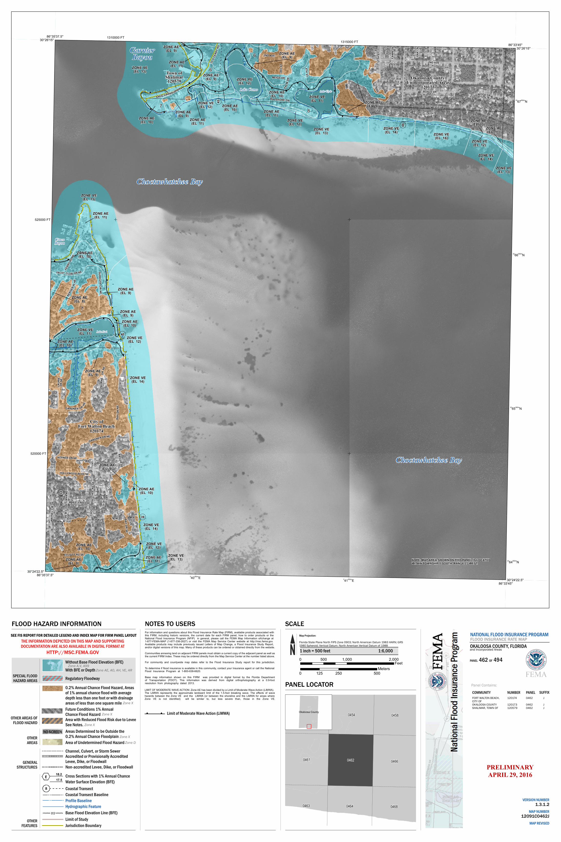
FLOOD HAZARD INFORMATION
SPECIAL FLOODHAZARD AREAS
OTHER AREAS OFFLOOD HAZARD
OTHERAREAS
GENERALSTRUCTURES
Without Base Flood Elevation (BFE)With BFE or DepthRegulatory Floodway
Area of Undetermined Flood Hazard
Areas Determined to be Outside the 0.2% Annual Chance Floodplain
Non-accredited Levee, Dike, or Floodwall
Zone A,V, A99Zone AE, AO, AH, VE, AR
Zone XZone D
HTTP://MSC.FEMA.GOVTHE INFORMATION DEPICTED ON THIS MAP AND SUPPORTINGDOCUMENTATION ARE ALSO AVAILABLE IN DIGITAL FORMAT AT
NATIONAL FLOOD INSURANCE PROGRAMFLOOD INSURANCE RATE MAPOKALOOSA COUNTY, FLORIDA
Panel Contains:COMMUNITY NUMBER PANEL SUFFIX
0462
04620462
J
JJ
FORT WALTON BEACH,CITY OFOKALOOSA COUNTYSHALIMAR, TOWN OF
120174
120173120579
SEE FIS REPORT FOR DETAILED LEGEND AND INDEX MAP FOR FIRM PANEL LAYOUT
Cross Sections with 1% Annual ChanceWater Surface Elevation (BFE)Coastal Transect
OTHERFEATURES
Profile BaselineHydrographic FeatureBase Flood Elevation Line (BFE)Limit of StudyJurisdiction Boundary
18.2
Accredited or Provisionally AccreditedLevee, Dike, or Floodwall
Coastal Transect Baseline
SCALE
0461 0466
0464
0454
0463
04580453
0468
0462
0 1,000 2,000500Feet
1 inch = 500 feet 1:6,000
Map Projection:
Florida State Plane North FIPS Zone 0903; North American Datum 1983 HARN; GRS 1980 Spheroid; Vertical Datum: North American Vertical Datum of 1988
0 250 500125Meters
PANEL LOCATOR
NOTES TO USERSFor information and questions about this Flood Insurance Rate Map (FIRM), available products associated with this FIRM, including historic versions, the current date for each FIRM panel, how to order products or the National Flood Insurance Program (NFIP) in general, please call the FEMA Map Information eXchange at 1-877-FEMA-MAP (1-877-336-2627) or visit the FEMA Map Service Center website at http://msc.fema.gov. Available products may include previously issued Letters of Map Change, a Flood Insurance Study Report, and/or digital versions of this map. Many of these products can be ordered or obtained directly from the website. Communities annexing land on adjacent FIRM panels must obtain a current copy of the adjacent panel as well asthe current FIRM Index. These may be ordered directly from the Map Service Center at the number listed above. For community and countywide map dates refer to the Flood Insurance Study report for this jurisdiction. To determine if flood insurance is available in this community, contact your Insurance agent or call the NationalFlood Insurance Program at 1-800-638-6620. Base map information shown on this FIRM was provided in digital format by the Florida Departmentof Transportation (FDOT). This information was derived from digital orthophotography at a 0.9-footresolution from photography dated 2013.
Channel, Culvert, or Storm Sewer
(( ((((
((
((
((
((((
((
((((
((
((
((((
((
((
(( (( ((
((
((((
((
((
((
((
((((
((
((
((((
((
((
((
((
((
((
((
((
((
((
((
((
((((
((
((((
(( ((
((
((((
((
((
((
((
((((
((
((
((((
((((
((
((
((
((
((((
((
((
((
((
((((
((
((
((((
((
(( ((
((
((
((
((
((
((
((
((((
((
((
((
((
((((
(( ((
((
((
((
((
((
((
((((
((
((
((
(((( ((
((
((((
((
((
((
((
((
((
((
((((
((
((
((
((((
((
((
((
((((
((
((
((
((
((
((
((
((
((((
((
((
((
((
((((
((
((
((
(( (( ((
.
.
.
.
.
.
.
Ñ
Ñ
Ñ
Ñ
.
.
.
.
DRPA
LM
OAK
LN
4TH ST
18
6
6
7
4
5
9
88
Choctawhatchee Bay
Lake Earl
Lake Como Lake Clyde
Town ofShalimar120579
ZONE AE(EL 11)
ZONE AE(EL 11)
ZONE AE(EL 10)
ZONE VE(EL 12)
ZONE VE(EL 11)
ZONE VE(EL 14)
ZONE VE(EL 13)
ZONE VE
WHEELER ST SE
(EL 16) ZONE VE(EL 12)
8TH
ST
ZONE VE(EL 13)
MEIGS DR
SUDDU THC IR
NE
1ST AVE
GARDNER D R NE
RDPRYOR
SE
CHO C
T AWH
ATCH
EE
HOLLYWOOD
RDSE
BLVD NE
DRGARDNER NE
B AYSHORE DR
OLD FE
RRY R
D
MEIGS DR
BOYCE DR
OSBOR
NE
DOGWOOD
KEPNER DR NE
DRSNUG HARBOUR DR
ST7T
H
(EL 13)
(EL 14)
Choctawhatchee Bay
BAY DR SE
ZONE AE(EL 10)
DRBAY
SE
ELLIOTT RD SE
OKAHATCHEE CIR SE
ZONE AE(EL 9)
City ofFort Walton Beach
120174
D RBA
YNE
ZONE VE(EL 11)
ZONE AE(EL 9)
ZONE VE(EL 14)
WAYN
EL C
IR S
E
CincoBayou
ZONE AE(EL 11)
ZONE VE
ZONE VE
DRNE
ZONE VE
AVE
Okaloosa County Unincorporated Areas
120173
FAWN
2ND AVE
2ND
ZONE AE(EL 10)
(EL 11)ZONE AE
3RD
ST
ZONE AE(EL 10)
ZONE AE(EL 10)
LN
(EL 14)
BayouZONE AE
(EL 9)
(EL 9)
ZONE AE
(EL 10)
ZONE AE
(EL 11)
ZONE AE
PL
YACHT
NE
CLUB
7
(EL 9)ZONE AE
ZONE AE(EL 10)
BERG
ER
(EL 9)
(EL 10)
Garnier
DR NE
(EL 9)
ZONE VE(EL 13)
ZONE VE(EL 12)
(EL 12)ZONE VE
ZONE VE(EL 13)
FERR
Y RD N
E
ZONE AE(EL 9)
(EL 9)ZONE AE
ZONE AE
ZONE AE
ZONE VE(EL 12)
ZONE AE
ZONE AE(EL 11)
ZONE VE(EL 12)
ZONE AE(EL 10)
ZONE AE(EL 9)
LAUR
IE
ZONE AE(EL 8)
DR N
E
30°24'22.5''86°35'37.5''
30°26'15''86°35'37.5''
30°26'15''86°33'45''
30°24'22.5''86°33'45''
3364000mN
3365000mN
3366000mN
3367000mN
540000mE 541000mE
520000 FT
525000 FT
1310000 FT1315000 FT
NOTE: MAP AREA SHOWN ON THIS PANEL IS LOCATEDWITHIN TOWNSHIP 2 SOUTH, RANGE 23 WEST.
(45
(46
( 13
(39
(40
17.5
0.2% Annual Chance Flood Hazard, Areas of 1% annual chance flood with average depth less than one foot or with drainage areas of less than one square mileFuture Conditions 1% Annual Chance Flood HazardArea with Reduced Flood Risk due to LeveeSee Notes.
Zone X
Zone X
Zone X
NO SCREEN
PRELIMINARYAPRIL 29, 2016
Okaloosa County
LIMIT OF MODERATE WAVE ACTION: Zone AE has been divided by a Limit of Moderate Wave Action (LiMWA).The LiMWA represents the approximate landward limit of the 1.5-foot breaking wave. The effects of wavehazards between the Zone VE and the LiMWA (or between the shoreline and the LiMWA for areas whereZone VE is not identified) will be similar to, but less severe than, those in the Zone VE.
(( (( Limit of Moderate Wave Action (LiMWA)
and Incorporated Areas
PANEL 462 OF 494
VERSION NUMBER1.3.1.2
MAP NUMBER12091C0462J
MAP REVISED