future growth opportunities urban design report...cbd rail link study – future growth...
TRANSCRIPT

Future Growth Opportunities – Urban Design Report
Appendix H Auckland CBD Rail Link Business Case
Prepared for KiwiRail and ARTA
By AECOM, Parsons Brinckerhoff & Beca (APB&B)
19 November 2010


CBD Rail Link Study – Future Growth Opportunities – Urban Design Report Page ii
Table of Contents
Executive Summary ................................................................................................... 1
1 Introduction .......................................................................................................... 2
1.1 Purpose of this Report ................................................................................................. 2
1.2 CBD Rail Link Project Scope ....................................................................................... 2
2 Understanding the existing framework for the future growth of Auckland ..... 3
2.1 Existing Growth Frameworks within the Auckland Region .......................................... 3
2.2 Auckland Regional Council’s Future Land Use and Transport Planning Project:
Evaluation of Future Land use and Transport Scenarios ............................................ 8
2.3 Other Matters ............................................................................................................. 10
3 Transit Oriented Development (TOD) ................................................................ 11
3.1 TOD Principles .......................................................................................................... 11
3.2 Summary of Potential TOD benefits .......................................................................... 12
3.3 Identification Criteria for Centres suited to TOD ....................................................... 12
4 Identification of Suburban TOD locations ........................................................ 14
4.1 Matters Considered ................................................................................................... 14
4.2 Suburban Centres Considered .................................................................................. 15
4.3 Recommended Suburban Centres for Further Investigation ..................................... 15
5 Assessment of Growth Opportunities .............................................................. 16
5.1 Aotea Station Precinct ............................................................................................... 16
5.2 Karangahape Road Station Precinct ......................................................................... 21
5.3 Newton Station Precinct ............................................................................................ 27
5.4 New Lynn Station Precinct ........................................................................................ 34
5.5 Panmure / Tamaki ..................................................................................................... 36
6 Towards a Pedestrian Orientated Auckland CBD ............................................ 39
Attachments
Attachment A – Indicative Development Typologies for CBD Rail Link Station Locations
Attachment B – Suburban TOD Location Assessment Matrix
Attachment C – Land Use and Height Studies for Newton and K Road Station Locations

CBD Rail Link Study – Future Growth Opportunities – Urban Design Report Page 1
Executive Summary
This report provides an overview of Transit Orientated Development (TOD) principles and benefits,
how TOD fits with the existing vision for Auckland City, and the physical form TOD may take around
station locations associated with the CBD Rail Link Project. To this end, this report demonstrates
that development facilitated, at least in part, by the CBD Rail Link project, has the potential to assist
in achieving densities for sustainable city growth as envisaged by the Auckland Regional and City
Councils.
While a number of growth strategies currently exist for the Auckland Region, all essentially aim for a
‘centres and corridors’ approach, whereby emphasis is on the establishment of a city form based of
higher density centres in conjunction with quality public transport to provide for sustainable
economic, environmental, social and cultural wellbeing. Such a spatial strategy clearly points
towards development of centres based on the principles of transit oriented development..
Through investigative modelling of typologies for development and gaining a thorough
understanding of the existing and future growth restraints and opportunities around the proposed
CBD Rail Link stations and a number of suburban stations, the potential for growth around the CBD
Rail Link and suburban stations has been identified. The intention has been to highlight potential for
growth in the context of sustainable ‘place making’ – attractive, memorable, human scale
environments that reinvigorate the culture of the local environment – while ensuring that such
growth is achievable and fits with the physical context of the environment.
For those CBD Rail Link stations located within and on the periphery of Auckland CBD, the focus of
the study has been on identifying potential employment growth opportunities. Acknowledging that
suburban station locations will ‘feed’ the rail network, New Lynn and Panmure have been
considered as case studies with regard to their potential to provide for future residential growth.
Subject to appropriate incentives, policy development and other interventions in favour of pedestrian
and transit orientated city (outlined throughout this report), the investigations undertaken have found
that land within close vicinity (circa 800m – 1000m radius, or ten minutes walking distance) of the
following station locations has the potential to experience significant employment and/or residential
growth:
Station Location Existing Density Potential Density
Aotea Station 500 employees per hectare 1,500+ employees per hectare
K Road Station 500 employees per hectare 550+ employees per hectare
Newton Station 500 employees per hectare 460+ employees per hectare
New Lynn Station Circa 20 dwellings per hectare 60+ dwellings per hectare
Panmure Station Circa 20 dwellings per hectare 40 – 80 dwellings per hectare

CBD Rail Link Study – Future Growth Opportunities – Urban Design Report Page 2
1 Introduction
1.1 Purpose of this Report
This report provides an understanding of the growth opportunities that will be facilitated, at least in
part, by the proposed CBD Rail Link Project. Written from an urban design perspective, it outlines
opportunities for future employment growth in the vicinity of the proposed Aotea, K Road and
Newton Station locations; and residential growth in the vicinity of suburban stations that will form
part of the wider rail network connecting with the Auckland CBD.
The investigations within this report have particular regard to the vision for Auckland as postulated
by the Auckland Regional and City Councils, and to the CBD regeneration benefits that are likely to
occur as a result of establishing the CBD Rail Link and associated transit orientated development.
Building upon existing policy development, the report explores the potential built form that could
realistically occur within the vicinity of each station locations and identifies the potential increases in
employment and residential densities associated with future growth. In doing so, the report also
identifies key actions that will need to be undertaken by stakeholders to assist in realising the vision
for sustainable growth of Auckland.
1.2 CBD Rail Link Project Scope
The CBD Rail Link aims to identify a preferred route for an underground passenger railway running
beneath the CBD, linking Britomart to the western line (North Auckland Line - NAL) in the vicinity of
Mount Eden. The CBD Rail Link will be approximately 3.5 km long and will include up to three
underground stations, with Britomart being converted from a terminus into a through station. The
Study will also consider the social, environmental and economic benefits and likely costs for the
proposed rail link and possible new stations along the way, and begin the process of protecting the
route for future construction.
The project methodology is broken down into three overlapping phases to enable a robust process
in the timeframe available. The phases are demonstrated below:
Phase 1: Undertake an options evaluation process to determine a preferred route alignment
options, station numbers, and station locations (the deliverable for this phase being a Draft
Options Evaluation Report).
Phase 2: Develop a preferred alignment concept design and undertake the associated technical
investigations; and develop the project business case.
Phase 3: Prepare and issue Notice of Requirement (NOR) documentation to KiwiRail and ARTA.
This report forms part of the project business case being prepared as part of Phase 2 of the overall
project.

CBD Rail Link Study – Future Growth Opportunities – Urban Design Report Page 3
2 Understanding the existing framework for the future growth
of Auckland
This section on the report provides a summary of the existing planning framework for the Auckland
region and an understanding as to why development patterns facilitated by TOD are considered
appropriate within the context of Auckland. It also assists to provide direction in the subsequent
identification of suburban TOD locations and also the development potential around the proposed
CBD Rail Link station locations.
While a number of growth strategies currently exist for the Auckland Region (under the various
Regional and City Councils), all essentially aim for a ‘centres and corridors’ approach, whereby
emphasis is on the establishment of:
A city form based of higher density centres in conjunction with quality public transport to provide
for sustainable economic, environmental, social and cultural wellbeing.
2.1 Existing Growth Frameworks within the Auckland Region
2.1.1 Auckland Regional Growth Strategy 1999 (RGS)
In response to concerns about the long term sustainability and economic performance of the
Auckland Region, Auckland Regional and City Councils voluntarily adopted the Regional Growth
Strategy (RGS) in 1999. It set out a vision of how the Region could grow sustainability over the next
50 years.
The RGS aims to sustain a strong and healthy community, a high quality living environment, a
region that is easy to get around and to protect the coast and surrounding environment. The RGS
growth concept plan was developed to show where future growth will be accommodated, and shows
a network of centres and corridors. Growth is to be concentrated around centres of various sizes to
create higher density walkable centres with a variety of jobs, services, recreation and other activities
(mixed use) connected by high quality public transport. In particular, the Strategy seeks the following
outcomes (amongst others):
Access and transport efficiency: more transport choices and high levels of access for all sections
of the community, a closer relationship between home and work, activities, shopping, open space
etc., managing traffic congestion and a better passenger transport system.
Sustainable use of resources: more efficiency in use of natural and physical resources, including
urban land, rural land, infrastructure and energy resources.
2.1.2 Auckland Regional Policy Statement: Plan Change 6 (PC6)
The Local Government Auckland Amendment Act 2004 (LGAAA) directed all territorial authorities in
the region to integrate their land use and transportation provisions and to give effect to the RGS. It
also established the Auckland Regional Transport Authority to plan, fund and develop the regional
transport network.
A suite of plan changes by all the territorial authorities soon followed on 31 March 2005 including
Plan Change 6 to the Auckland Regional Policy Statement (RPS) and Plan Change 175 to the
Auckland City Distinct Plan (Isthmus).
PC6 to the RPS provided the first attempt to recognise that some centres would be important for
performing functions that are important for the whole region such as the CBD while others will focus

CBD Rail Link Study – Future Growth Opportunities – Urban Design Report Page 4
on serving their regional or local catchments. It also provided employment and household density
guidelines for centres and corridors necessary to support public transport.
PC6 affirms centres and corridors as a key mechanism to implement the Growth concept. Schedule
1 of the Plan Change identifies 1 CBD, 10 sub-regional centres, 40 town centres, and 2 corridors,
requiring district plan changes for 48 centres to be commenced by 2010. The development of these
areas is intended to provide for growth to 2020.
PC6 recognises that existing infrastructure investment in town centres and passenger transport
nodes should be reinforced by increases in residential densities and in the diversity and quantity of
mixed use activities within walking distance of high density centres creating a compact, contained
urban form. Schedule 1 of PC6 sets out the areas where the strategic policy supports urban
intensification (including those areas located on the Auckland rail network).
As outlined in section 2.5 of the PC6 an overview of the issues arising in the Region leads to the
conclusion that to achieve the purposes of the Resource Management Act and Local Government
(Auckland) Amendment Act 2004 it is necessary to:
Contain expansion of Auckland’s urban development while still providing for population and
economic growth; and
Require that town centres, transport nodes, high density centres and corridors within the
metropolitan urban limits are the focus for accommodating urban growth through intensification.
Further, specific policies seek that land use and transport shall be integrated within high density
centres to assist in achieving mutually supportive outcomes. PC6 defines high density centres to
include specific localities selected for urban intensification due to physical or locational
characteristics that include the intensity of existing development, the locality’s generation of, or
association with, significant transport movements, and/or passenger transport nodes, and the
locality’s capacity for further growth. These the CBD, sub regional centres and town centres.
Section 2.6.13 outlines that the densities required in Appendix H are average minimum densities
required within the high density centre or corridor. However, it is equally important that the highest
densities occur closer to the transport interchange, graduating to lower densities towards the edge
of the centre. Every centre however has its own characteristics and while every effort should be
made to reach these densities this must be done with regard to achieving high quality urban design
outcomes.
Figure 1: Appendix H of PC6 – Household and Employment Densities Required in High Density Centres and
Corridors to Support the Public Transport System
CBD Rail Link Study – Future Growth Opportunities – Urban Design Report Page 5
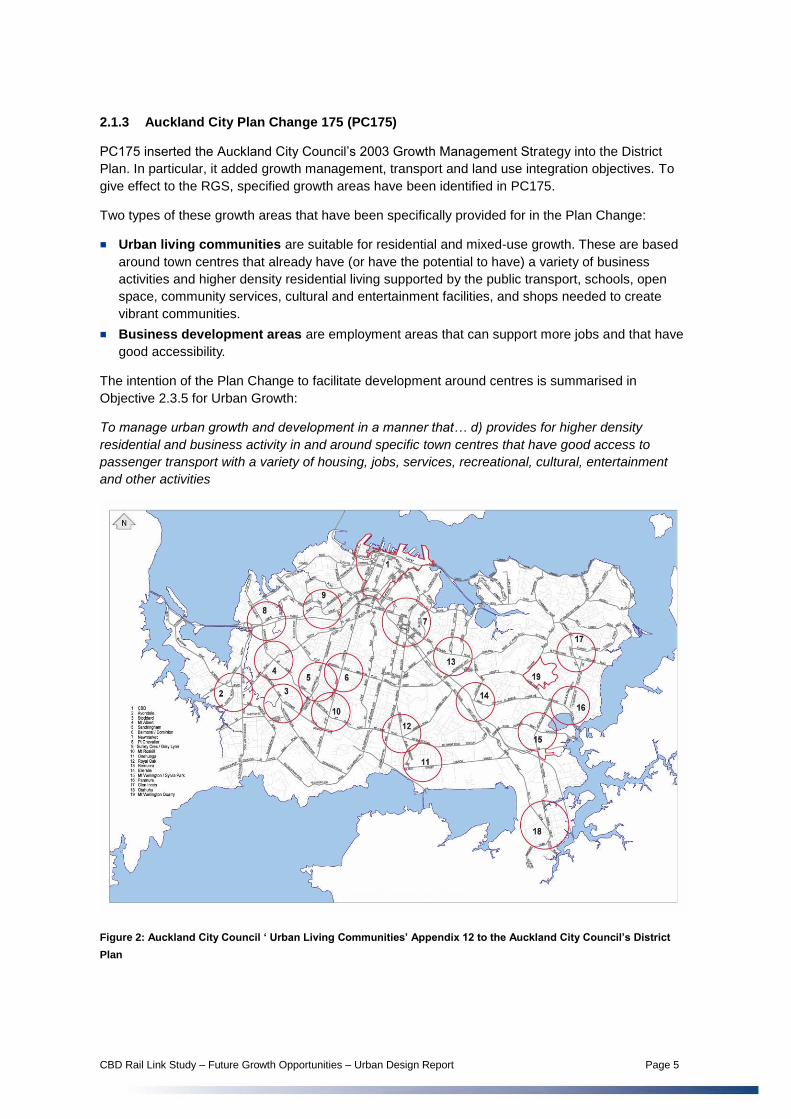
2.1.3 Auckland City Plan Change 175 (PC175)
PC175 inserted the Auckland City Council’s 2003 Growth Management Strategy into the District
Plan. In particular, it added growth management, transport and land use integration objectives. To
give effect to the RGS, specified growth areas have been identified in PC175.
Two types of these growth areas that have been specifically provided for in the Plan Change:
Urban living communities are suitable for residential and mixed-use growth. These are based
around town centres that already have (or have the potential to have) a variety of business
activities and higher density residential living supported by the public transport, schools, open
space, community services, cultural and entertainment facilities, and shops needed to create
vibrant communities.
Business development areas are employment areas that can support more jobs and that have
good accessibility.
The intention of the Plan Change to facilitate development around centres is summarised in
Objective 2.3.5 for Urban Growth:
To manage urban growth and development in a manner that… d) provides for higher density
residential and business activity in and around specific town centres that have good access to
passenger transport with a variety of housing, jobs, services, recreational, cultural, entertainment
and other activities
Figure 2: Auckland City Council ‘ Urban Living Communities’ Appendix 12 to the Auckland City Council’s District
Plan

CBD Rail Link Study – Future Growth Opportunities – Urban Design Report Page 6
2.1.4 Auckland City Future Planning Framework
As outlined within the future planning framework introduction, this strategy has been developed to support Auckland City Council’s overarching vision for Auckland city and its high-level strategies… The Framework comprises a synopsis of the research recently completed, a citywide spatial framework and ten area plans. A hierarchy of centres has been developed to identify each centre’s future role in the centre’s network… Types of centres include the CBD, principal centres, town centres, local centres and neighbourhood shops.
With regard to transport and growth, section 2.8.2 states:
Auckland city’s transport system has a critical role to play in supporting Auckland city’s growth and
development, reducing carbon emissions and sustaining its economy. The transport choices map
shows how the transport network will be developed to improve connections in key areas and to
promote transport choices.
The quality built environment map shows that the majority of future growth will be directed to centres
and corridors that are on or close to major transport routes and services, particularly around
suburban railway stations.
Figure 3: Auckland City Council City Quality Built Environment Map, showing proposed centres in alignment with
rail network.
Appendix 6.1 of the Planning Framework outlines the Council’s approach to future residential
population growth. In particular, it makes the following statements:
The council’s approach to the location of additional growth capacity in the future planning
framework is based on the following ideas:
A more compact and sustainable city to pass on to future generations the need to develop a
strong CBD and a network of strong centres linked by increasingly well-served public transport
routes, arranged in a functional hierarchy. This hierarchy comprises, in order of magnitude and
diversity of services: the CBD, principal centres, town centres and local centres.

CBD Rail Link Study – Future Growth Opportunities – Urban Design Report Page 7
Having regard to the above, the Framework outlines the following projected growth patterns:
Appendix 6.2 outlines that it is estimated an additional 380,000-400,000 employees will be working
in the Auckland isthmus in the year 2051, bringing the total to around 700,000 employees from
309,300 in 2007. The council aspires to accommodate this growth in employment, within the spatial
context of the future planning framework, as outlined within the following table:
2.1.5 Manukau City Council – Towards 2060, draft 2009
Manukau City Council’s Towards 2060 is a spatial strategy for the future growth of Manukau City.
The strategy sets out six categories of centres within a hierarchy for existing urban centres ranging
from Regional Centre through to Local Centres. As outlined within the strategy, the strategic intent is
to provide a spatial pattern of growth and development that offers access to employment, retail,
office space, services, a broader mix of housing types, recreation, leisure and community facilities
and activities in the widest possible clustering and to the greatest number of people. To achieve this,
planning, investment and development processes will encourage growth and redevelopment at
those centres and corridors that are well-located in terms of transport accessibility and where such
development is appropriate. Only limited development outside the centres and corridors will be
supported.
Of note, policy intervention 1.4 seeks to promote selective intensified development and improve the
sustainability of residential areas through support of high-quality, medium and higher-density
residential development and housing options in centres and corridors where suited to location and
community context, noting that key trip generators, such as regional, principal, district and specialist
centres, and higher density residential development located on the Quality Transport Network (QTN)
and Rail Transport Network (RTN), will receive priority focus.

CBD Rail Link Study – Future Growth Opportunities – Urban Design Report Page 8
2.1.6 Waitakere City Council Proposed Changes 13 – 18 - Growth and Transport Integration
Programme
Waitakere City Council initiated a 'Growth and Transportation Integration Programme' to align with
the RGS which has resulted in a number of Plan Changes to the Waitakere District Plan. While the
proposed plan changes are not a single growth strategy, together they respond to the LGAAA
direction for all territorial authorities in the region to integrate their land use and transportation
provisions and to give effect to the RGS.
These plan changes aim to:
Manage and direct urban growth and rural development in an integrated manner;
Progress the intensification of Waitakere around the major town centres, including the
redevelopment of the New Lynn Town Centre; and
Expansion of the Metropolitan Urban Limits (MUL) at Hobsonville and Massey North to allow for,
in particular, the development of additional employment land to meet the needs of the growing
community not able to be met in the existing urban area.
2.1.7 Waitakere City Council – Growth Management Strategy for Waitakere 2009
Waitakere City Council’s Growth management Strategy is a spatial strategy for the future growth of
Waitakere City. The strategy sets what form growth could take in the future and provides more
detailed area profiles for the significant and identified growth areas across the City.
The Growth Management Strategy sets out a vision, goals, pathways, and targets to deliver the
spatial plan. Of note are the following Strategic Growth Management Principles:
Most urban growth should be focused around town centres and major transport routes to create
higher density communities, with a variety of housing, jobs, services, recreational and other
activities (mixed use)
This strategy supports transport efficiencies by encouraging high density mixed use development
in town centres and transport nodes and limited growth in outlying rural areas. Mixed use
polycentric (multiple centre) development is crucial to support public transport and minimise
cross town travel, as people can work within a close proximity to where they live.
2.2 Auckland Regional Council’s Future Land Use and Transport Planning
Project: Evaluation of Future Land use and Transport Scenarios
The following paragraphs are taken directly from the Auckland Regional Council’s Future Land Use
and Transport Planning Project: Evaluation of Future Land use and Transport Scenarios. These
represent a summary of the outcomes that are considered pertinent to this report.
The Future Land Use and Transport Planning Project (Futures Project) seeks to identify a long term
spatial vision for the region, including the location of future development and supporting
infrastructure, able to accommodate 2.3 million people by 2051. This report focuses on the third
round evaluation of three land use and transport scenarios to determine which spatial form could
best meet agreed regional outcomes. (Page 1).
Each of the three scenarios represents a different urban form. These incorporate varying levels of
intensification, growth beyond metropolitan urban limits, and locations for future residential and
employment growth. However, they fit into two broad categories; the compact scenarios (Scenario 1
and 4) and the Expansive Scenario (Scenario 5). (Page 1).

CBD Rail Link Study – Future Growth Opportunities – Urban Design Report Page 9
Overall, a compact urban form is preferable for Auckland’s future urban form. For most criteria the
compact scenarios perform the best by having, for example (Pages 5-6):
Less impact on the environment, by avoiding pristine and valued environmental areas and better
protecting stream corridors and marine values;
Improved regional productivity by enabling firms to better access skilled labour and key ports;
Provision of a strong network of centres enabling better social cohesion and access to social
facilities.
The results point to a spatial form that is based predominantly on compact principles.
The main conclusions from this evaluation for a future integrated land use and transport are:
A need for a strong network of centres, including local centres, which provide opportunities for
greater accessibility and can enhance social cohesion.
Supporting the transport network with associated residential and employment growth as this
leads to improvements in overall accessibility and regional productivity.
Ongoing and long term investment in transport infrastructure, particularly passenger transport, to
support a changing urban form and to ensure accessibility improvements continue over the long
term.
It is worthwhile noting that the compact scenarios assume the construction of the CBD Rail Link
along with other major transport initiatives in the future. By way of summary, the following tables
(page 13 of the report) summarise the envisaged outcomes of the three scenarios, where by the
compact scenarios clearly provide for development based on 70 per cent of additional dwellings and
employee capacity in centres (including the CBD and CBD Fringe).
Figure 4: Additional dwellings and employees envisaged by compact and expansive scenarios within the Auckland
Regional Council’s Future Land Use and Transport Planning Project: Evaluation of Future Land use and Transport
Scenarios.
What is clear from the report is that Auckland regional Council’s research has shown a preference
towards a compact spatial plan for Auckland and that such an approach will likely be incorporated
into the future spatial plans of the Auckland Council to be formed in November 2010.

CBD Rail Link Study – Future Growth Opportunities – Urban Design Report Page 10
2.3 Other Matters
2.3.1 Auckland Regional Policy Statement: Plan Change 8
The Auckland Regional Policy Statement Plan Change 8 (PC8) relates to landscape and volcanic
features. In regards to the future TOD locations, the volcanic features part of PC8 is relevant. PC8
recognises that the volcanic cones of Auckland are iconic, of international, national and regional
significance and gives the region a unique character and identity, which sets Auckland apart from
other cities in the world.
PC8 acknowledges that the physical and visual integrity of the volcanic field can be adversely
affected by inappropriate development (i.e. unsympathetic building height) and compromised views
to the cones. As such a precautionary approach is considered appropriate in acknowledgement of
the irreversibility of many of the effects to protect and enhance the visual and physical integrity of
the cones and to protect significant views to the cones. Protected viewshafts of relevance to the
development within identified station locations include:
E10 (from Onewa Interchange to Mt Eden); and
E16 (from the Auckland Harbour Bridge to Mt Eden).

CBD Rail Link Study – Future Growth Opportunities – Urban Design Report Page 11
3 Transit Oriented Development (TOD)
An appropriate approach to achieve the urban growth outcomes envisaged by Auckland Regional
and City Councils is through Transit Orientated Development (TOD). TOD is a mixed-use residential
and/or commercial area designed to maximize access to public transport and often incorporating
features to encourage transit ridership. In line with contemporary design principles, a TOD
neighbourhood typically has a centre with a train/metro station, bus/tram stop, surrounded by higher
density development (relative to the surrounding area) with progressively lower-density development
spreading outwards from the centre. TOD is generally located within a radius of 400 to 800 m from a
transit stop, as this is considered to be an appropriate scale for walking distance of between five and
ten minutes.
An important aspect to TODs is that they take time to mature and will only reach their full potential
with cooperation between the public and private sector. A well managed, inclusive partnership
between transit agencies, local government, developers and the public is essential if the vision for a
TOD is to be realised. While a proposed station will assist to facilitate development, it is not the only
catalyst. Incentives to developers (such as more permissive planning regulations) and upgrades to
public realm are likely to be required to attract investors, employees and residents to an area. The
vision needs to be beyond numbers, but one of sustainable ‘place making’ – creating attractive,
memorable, human scale environments that reinvigorate the culture of the local environment.
3.1 TOD Principles
The principles of TOD are generally agreed by practitioners and theorists. Falconer and Richardson
have stated the following ten key principles that should be understood when planning and designing
TODs:1
Plan a walking scale town – the TOD will cover an area of approximately 200ha, allowing for
most journeys within the TOD to be undertaken by foot or bicycle;
A TOD should have a centre – ideally this will be a mixed use centre anchored around a rail
station or other transport node;
Quality streets and public places – active, safe, comfortable and attractive streets will be a key
element in determining the success of a TOD. Streets should be of a fine grain, providing for a
highly permeable, connected environment;
A diverse mix and a sufficient size – mixed use and densities that bring vibrancy to the station
location need to be facilitated;
A public transport hub – TOD should provide opportunity for public transport interchange, which
will attract people from locations other than those on the rail route, assisting the TOD location to
grow as a vibrant centre;
Low speed car access – While car access should continue to be provided, pedestrian safety and
comfort should take precedence within the TOD location;
An appropriate level of car parking – Car parking should be discouraged and provided in lower
numbers relative to surrounding development.
Location of public off-street car parks – public car parks should be provided at the periphery of
the TOD location, such that conflict between pedestrians and vehicles is minimised and use of
public transport is encouraged;
1 Falconer, R and Richardson, E, Rethinking urban land use and transport planning – opportunities for transit
oriented development in Australian cities, Australian Planner, Vol 47, No 1, March 2010

CBD Rail Link Study – Future Growth Opportunities – Urban Design Report Page 12
An appropriate level of bicycle parking – Bicycle parking should be provided within commercial
and residential developments at a minimum 10% of living and working populations. Secure,
attractive bicycle parking should also be provided at station locations, encouraging use between
destinations.
Limit barriers to accessibility – wherever possible, barriers to accessibility, such as busy roads or
areas perceived to be unsafe, should be avoided, providing opportunity to maximise safety,
permeability and connectivity.
3.2 Summary of Potential TOD benefits
Literature review, including case studies, points towards a variety of benefits in relation to TOD. The
benefits are wide ranging and have been identified as including2:
Increase ridership and fare revenues;
Potential for joint venture development opportunities;
Better places to live, work and play – TODs have the potential to result in revitalised
neighbourhoods. Through a variety of catalyst projects, such as rail station development and
public realm and/or facility upgrades, TODs have the potential to breath new life into areas that
have seen little or no growth in recent years;
Reduced crime and increased safety, through revitalisation of the TOD location (facilitated
through greater passive surveillance);
Greater mobility with ease of moving around and subsequent increase in transit ridership and
decrease in congestion and private vehicle use;
Higher, more stable property values (whilst providing for a variety of housing types and costs);
Infill development reduces the need for green field development and associated cots, e.g road
expenditure
Increased employment opportunities; and
Increased foot traffic and retail sales for local businesses;
Increased access to labour pools through enhanced local and regional connectivity;
Increased physical activity (and subsequent health benefits) – recent studies show that public
transport commuters walk up to five times the distance than that of private vehicle commuters3.
3.3 Identification Criteria for Centres suited to TOD
Auckland Regional Policy Statement PC6 lists a number of high density centres in which
intensification can occur in line with the Strategy. The Plan Change outlines appropriate areas as
land where the existing amenities, social infrastructure, utility systems and the transport network
have capacity to service higher density forms of residential and non-residential development.
Further to this, Auckland City Council identified a number of matters within their growth
management strategy that identifies if an area is an ‘area of change’ or able to accommodate
increased development. These are considered relevant to the identification of suitable TOD areas
and include:
2 R. Cervero, et al. TCRP Report 102: Transit-Oriented Development in the United States: Experiences,
Challenges and Prospects, Washington D.C: Transportation Research Board, 2004
3 Research undertaken by Bus Association of Victoria (The Age, Friday March 12, 2010)

CBD Rail Link Study – Future Growth Opportunities – Urban Design Report Page 13
Urban living communities (residential, mixed use town centres):
Town centre with capacity for more people to live within an 800m radius;
Primary school or another community anchor, community facilities;
Open space;
Passenger transport or good road access;
Stormwater infrastructure;
Environmental qualities not threatened by growth;
Market interest.
Business development communities (employment and commercial areas):
Service centre with capacity to support job increases within a 1km radius;
Good road or passenger transport access for workers;
Good road or rail access for goods;
Environmental qualities not threatened by growth;
Market interest.

CBD Rail Link Study – Future Growth Opportunities – Urban Design Report Page 14
4 Identification of Suburban TOD locations
In addition to outlining the potential growth opportunities around the proposed CBD Rail Link
stations, this report seeks to provide an understanding of opportunities for suburban centres located
on the rail network that have the potential to benefit from the CBD Rail Link project. Accordingly, this
section outlines the process undertaken to identify two suburban centres within the greater Auckland
region that were further investigated in terms of their potential to provide for residential and
employment densities.
4.1 Matters Considered
Starting at Britomart and working out along each of the eastern, southern and western rail lines,
consideration was given to each of the majority of station locations in terms of their ability to provide
for the largest absolute growth potential, with particular consideration given to multifamily residential
activity (e.g. apartment type development) to generate and maximise new ridership. Station
locations within established industrial or business areas that were considered unlikely to see
residential development in the future were not considered.
Drawing on the team’s knowledge and ‘on the ground’ understanding of the station locations,
particular consideration was given to the following matters:
Recognised potential for the area to intensify development, taking into city strategies, e.g. ACCs
Future Planning Framework
Existing amenities within the area, including open space, schools, shopping and recreation
facilities, suitable for supporting residential population
Vacant land, suitable for immediate redevelopment
Redevelopment opportunities, e.g. industrial land; dated commercial development or residential
development
Land ownership patterns, e.g. large areas within single ownership such as Housing NZ
Existing built character, including heritage
Existing densities / lot sizes provide for development potential
Potential for environment / landscape to absorb change, e.g. existing view shafts to remain
protected
Topographical or geological constraints, e.g. ability to construct buildings on stable land
In addition, consideration has been given to the following Auckland strategy documents (amongst
others):
Auckland City Council - Future Planning Framework (2009) including relevant precinct plans
Auckland Regional Council - Future Land Use and Transport Planning Project, April 2010
Auckland Regional Policy Statement (Plan Change 6)
Growth strategies for Waitakere and Manukau City Councils
Consideration was given to findings of the APB&B Team in relation to the same study, particularly:
Findings in relation to station location employment and growth analysis, as provided by Kumar
Kintala on 25 and 26 July 2010
Potential TOD locations discussion document, as provided by Neil Prosser on 25 July 2010

CBD Rail Link Study – Future Growth Opportunities – Urban Design Report Page 15
4.2 Suburban Centres Considered
Detailed consideration was given to the following station locations:
Orakei
Meadowbank
Glen Innes
Panmure
Sylvia Park
Otahuhu
Middlemore
Papatoetoe
Manurewa
Takanini
Papakura
Newmarket
Ellerslie
Penrose
Kingsland
Morningside
Mt Albert
Avondale
New Lynn
Glen Eden
Henderson
In particular, consideration was given to those matters outlined in Section 2 above, with each
location being rated as to its potential to respond to those matters, i.e. 0 = No potential; 1 = Low
potential; 2 = Medium potential; 3 = Good potential. Attachment B ‘Summary of Station Location
Potential for TOD’ is attached to this report and summarises the outcomes of the above process.
Overall, New Lynn, Panmure and Sylvia Park were identified as having the most potential as future
TOD locations with significant potential for residential living opportunities. Each of these locations is
discussed in further detail below.
Note: It should be acknowledged that the process used in the identification of potential TOD
locations has been a high end analysis only and further detailed investigation may result in different
outcomes. Notwithstanding, the identified stations would likely remain in the top tier of any further
investigations and are considered to be appropriate for further investigation for the purposes of the
CBD Rail Link project.
4.3 Recommended Suburban Centres for Further Investigation
4.3.1 New Lynn
Figure 5: New Lynn Google Images, with 400m and 800m distance circles around existing station location

CBD Rail Link Study – Future Growth Opportunities – Urban Design Report Page 14
New Lynn is located in Waitakere City and has been identified as a suitable TOD location. A plan
change process to intensify commercial and residential land uses has been undertaken and
investment in the integration of the train station and bus depot has commenced. Heavy investment
in New Lynn aims for it to become the ‘Newmarket’ of Waitakere City and provide both residential
and employment hubs. The RGS identifies New Lynn as an existing residential/mixed use area and
a future sub regional centre (which is defined to accommodate 60 dwellings/ha and 300
employees/ha).
There is realistic potential for the area to develop as a TOD on the basis that:
New Lynn area has already been signaled as a TOD development with significant work
undertaken by Waitakere City Council in regard to the future planning and urban design of the
area. As outlined on Waitakere City Council’s website, the concept plans show a great deal of
high-rise, high-density housing close to the town centre, to house up to twice as many people as
presently live in New Lynn. These will mostly be people who have adopted the urban lifestyle so
common overseas: living in apartments, working close to home, owning businesses in the town
centre, commuting by train and bus, walking and cycling.
Auckland Regional Council classification as Sub-Regional Centre (refer Plan Change 6,
Auckland Regional Council Policy Statement)
Auckland City Council classification as Principal Centre (noting that this area lies outside of the
Auckland City jurisdiction).
Good provision of community amenities including library, open space, schools in close vicinity
Close proximity to retail and employment areas
Brownfields sites for potential (re)development
Large landholdings, including Waitakere City Council
Does not possesses a built character or heritage that would otherwise preclude redevelopment
or higher densities
Future planning for the area anticipates higher densities with good potential to be absorbed
within the surrounding landscape (e.g. there are no limitations due to adjoining landscape or view
shafts etc)

CBD Rail Link Study – Future Growth Opportunities – Urban Design Report Page 15
4.3.2 Panmure / Tamaki
Figure 6: Panmure Google Images, with 400m and 800m distance circles around existing station location
There is realistic potential for the area to develop as a TOD on the basis that:
Auckland Regional Council classification as a Town Centre (refer Plan Change 6, Auckland
Regional Council Policy Statement)
Auckland City Council classification as a Town Centre
Part of the overall area that will benefit from the Auckland Manukau Eastern Transport Initiative
Very good provision of community amenities including open space, recreation (swimming pool,
health centre) library, and schools in close vicinity
Close proximity to existing retail and business areas
Brownfields sites for potential (re)development
Large landholdings
Does not retain a built character or heritage that would otherwise preclude redevelopment or
higher densities
Future planning for the area anticipates higher densities with good potential to be absorbed
within the surrounding landscape; however, there are height limitations over some of the area as
a result of the proximity to Mt Wellington. These range from 12m-15m and cover only parts of the
envisaged developable area.
Future Planning Framework seeks the following outcomes:
– Developing the Tāmaki Innovation Precinct and New Zealand Innovation Centre, as a hub for
cutting edge technology focused businesses
– Focusing growth in and around the Glen Innes and Panmure town centres to make the most
of the great access to rail and bus services, shops and community facilities and to act as a
catalyst for rejuvenating these centres
– Advocating for Tāmaki Railway Station to be reopened, with an adjacent business node to
support it
– Making the most of the area's volcanic landscapes and waterways, promoting their ecological
values and recreational use.

CBD Rail Link Study – Future Growth Opportunities – Urban Design Report Page 16
5 Assessment of Growth Opportunities
Having regard to those matters outlined in section 3.2 above, the following sections outline the
potential growth opportunities and benefits around the CBD Rail Link and suburban stations
identified above. As has been noted early in this report, the opportunities and benefits have been
considered from an urban design perspective. The intention is to highlight growth opportunities in
the context of sustainable ‘place making’ (i.e. creating attractive, memorable, human scale
environments that reinvigorate the culture of the local environment), and provide an understanding
of the potential growth that can be physically absorbed within the each station location.
For those stations located within and on the periphery of Auckland CBD, the focus of the following
sections has been on potential employment growth within these areas. While residential growth will
occur within and on the periphery of the CBD, these areas are predominately attractors for
employees. Conversely, suburban station locations will ‘feed’ the rail network and, accordingly, New
Lynn and Panmure have been considered with regard to their potential to provide for future
residential growth.
5.1 Aotea Station Precinct
The proposed Aotea Station, with a primary entrance located on the corner of Mayoral Drive and
Wellesley Street, provides for access to the heart of CBD and Auckland’s commercial core.
Shopping activities also remain a large draw card to the city with stores such as Smith and Caughey
drawing up to 3 million people per year. Auckland City Council has also indicated the following
visitor numbers to the CBD for non-residential and commercial activities within closed vicinity of the
proposed Aotea Station:
Auckland Central Library – 1.2 million
Auckland City Art Gallery – 450,000 (anticipated with redevelopment)
The Edge (combined Aotea Centre, Town Hall, Civic theatre) – 1 million
SkyCity Cinema complex - 6.7 million
SkyCity (SkyTower) - 1 million +
University students at AUT University and University of Auckland campuses total approximately
50-60,000 per day. Significant campus redevelopment may see this grow by a further 10-20%.
As has been evidenced by similar public transport developments in other cities around the world, the
benefits of station development are accrued at their highest within a five minute walking distance
and, to a lesser extent, within the five to ten minute walking distance from the station. In addition to
including a number of significant attractors and existing commercial development, the Aotea Station
walking catchment includes a number of vacant sites (including car parking sites at the corner of
Victoria and Albert Streets, and Wellesley Street and Mayoral Drive), large sites in common
ownership and buildings that have reached the extent of their valued life. A ‘station premium’ is likely
to assist in facilitating the redevelopment of sites within walking distance of the station. Such sites
offer the potential to maximise the relationship between future development and the proposed
station location, either through public private partnerships or other initiatives.
5.1.1 Planning for a revitalised CBD
A number of physical constraints currently have the potential to restrict the future attractiveness of
the CBD to grow as an attractive pedestrian friendly city, including:
Heavily trafficked roads

CBD Rail Link Study – Future Growth Opportunities – Urban Design Report Page 17
Low amenity streets
Areas of limited passive surveillance
Areas of reduced pedestrian amenity
On-going improvements to the public realm will likely have the benefit of attracting people to use
and invest in the area, and also have the potential to assist in increasing rent premiums. In
particular, the following public realm potentials and opportunities have been identified within close
vicinity to the proposed Aotea Station:
Mayoral Drive: Currently there is little frontage onto this street, although the street does benefit
from good sun and is relatively wide, enabling the opportunity for enhanced public realm. It is
considered that the opportunity exists for buildings to front Mayoral Drive, engaging with a high
amenity pedestrian friendly realm.
Figure 7: Indicative section potential for a main Aotea Station entrance and commercial / civic tower above, at corner
of Wellesley Street and Mayoral Drive. Such a development would have the potential to be integrated with high
quality public realm, connecting between the station, Aotea Station and the Town Hall.
Federal Street: The opportunity exists to enhance public realm and active facades along this
north south desire line.
Aotea Square: The provision of a station and/or other catalyst project on the periphery of Aotea
Square has the potential to enhance access to the city’s premier cultural and civic precinct.
Albert and Victoria Streets: The width of Albert Street provides potential for pedestrian realm
improvements. The street also provides for legible, quick connections with Victoria Street and
existing bus routes. The potential exists to provide for good access down to Elliot, Darby and
Queen Streets and, given the number of bus routes within the area, this area also has the
potential to become a multi modal public transport interchange.
CBD Rail Link Study – Future Growth Opportunities – Urban Design Report Page 18
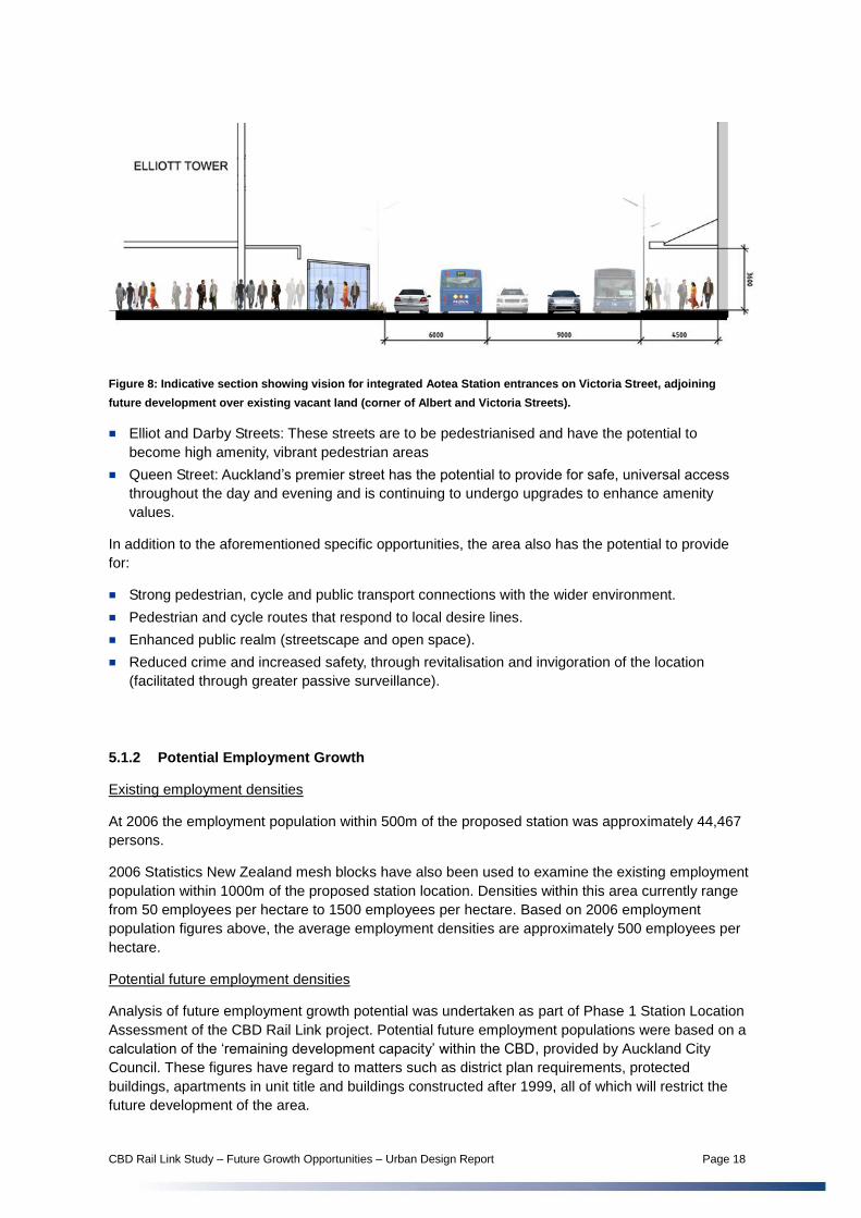
Figure 8: Indicative section showing vision for integrated Aotea Station entrances on Victoria Street, adjoining
future development over existing vacant land (corner of Albert and Victoria Streets).
Elliot and Darby Streets: These streets are to be pedestrianised and have the potential to
become high amenity, vibrant pedestrian areas
Queen Street: Auckland’s premier street has the potential to provide for safe, universal access
throughout the day and evening and is continuing to undergo upgrades to enhance amenity
values.
In addition to the aforementioned specific opportunities, the area also has the potential to provide
for:
Strong pedestrian, cycle and public transport connections with the wider environment.
Pedestrian and cycle routes that respond to local desire lines.
Enhanced public realm (streetscape and open space).
Reduced crime and increased safety, through revitalisation and invigoration of the location
(facilitated through greater passive surveillance).
5.1.2 Potential Employment Growth
Existing employment densities
At 2006 the employment population within 500m of the proposed station was approximately 44,467
persons.
2006 Statistics New Zealand mesh blocks have also been used to examine the existing employment
population within 1000m of the proposed station location. Densities within this area currently range
from 50 employees per hectare to 1500 employees per hectare. Based on 2006 employment
population figures above, the average employment densities are approximately 500 employees per
hectare.
Potential future employment densities
Analysis of future employment growth potential was undertaken as part of Phase 1 Station Location
Assessment of the CBD Rail Link project. Potential future employment populations were based on a
calculation of the ‘remaining development capacity’ within the CBD, provided by Auckland City
Council. These figures have regard to matters such as district plan requirements, protected
buildings, apartments in unit title and buildings constructed after 1999, all of which will restrict the
future development of the area.

CBD Rail Link Study – Future Growth Opportunities – Urban Design Report Page 19
The ‘remaining development capacity’ was calculated within 500m of the proposed station location
to result in the potential future population within that area. The figures assume 75% of the
‘remaining development capacity’ will be developed, at a commercial/residential ratio of 4:1, and an
employee occupancy of one person per 25sqm. Based on these assumptions, the following
employee numbers were calculated:
2006 Employment Population within 500m of
Aotea Station
Realistic Future Employment Population within
500m of Aotea Station
44,467 79,788
Figure 9: Auckland City Council mapping of existing sites with capacity for future development pursuant to existing
policy.
While the above numbers represent a significant increase in employee numbers, they nonetheless
remain relatively low at approximately 1000 employees per hectare. Building upon the above
indicative calculations, Attachment A – ‘Indicative Development Typologies for CBD Rail Link
Station Locations’ outlines four typologies for the Aotea Station Precinct, which are indicative of the
type of future built form that may occur in the area, particularly should public transport improvements
be facilitated. Such improvements are likely to lead to a ‘station premium’ within the five to ten
minute walking catchment of the station, whereby commercial land values will see a noticeable
increase over time.

CBD Rail Link Study – Future Growth Opportunities – Urban Design Report Page 20
Each typology has been applied to a specific site. The four typologies, illustrated on pages 3, 4 and
5 of Attachment A, are summarised as:
Typology A - tall tower, 45 storeys
Typology B - mid-rise tower, 25 storeys
Typology C - low rise slab on a podium, 10 storeys
Typology D - mid rise podium and tower development, 11 storeys
The table below provides an indicative breakdown of employment densities in relation to the
typologies investigated
Typology Employment Density over Site
(employee/ha)4
Floor Area Ratio
A 11,712 35.60 : 1
B 2,161 5.75 : 1
C 1,090 2.37 : 1
D 2,286 6.14 : 1
The above densities relate to a range of development types that could realistically occur within the
Auckland CBD. Based on the combined aggregate employment density per hectare, and taking into
account provision for roads, public spaces and other non-developable areas, it is considered that an
average density of 1,500 – 2,250 employees per hectare could be expected to develop within
commercial blocks in the surrounding 800m – 1000m catchment of the proposed station location
between now and 2041, subject to appropriate policy initiatives and other interventions5. Without the
CBD Rail Link, any significant increase in employment densities is unlikely to be facilitated in the
area.
5.1.3 Future Planning Considerations
To achieve those densities described above, consideration needs to be given to incentives for future
investment. In particular, consideration should be given to:
Implementing those opportunities described in section 5.1.1.above
Zoning / plan changes to enable as of right development (including increased height allowance)
Incentives for amalgamations
Incentives for infill development of small sites
Tax / rates incentives
4 Site densities are based on the gross area of built form on a particular site, and should not be interpreted as
being applicable to the wider area.
5 Based on a 50%-80% uptake of the combined aggregate employment densities per hectare; and assuming an
entirely commercial land use.

CBD Rail Link Study – Future Growth Opportunities – Urban Design Report Page 21
Potential for mixed use development
Establishment of catalyst projects (such as new public buildings) to attract further use of the area
Achieving environmentally, socially and culturally sustainable outcomes, in addition to economic
benefits.
5.1.4 Summary
In summary, it is considered that Auckland CBD, through the establishment of the CBD Rail Link
and other catalyst projects in favour of the public, has the potential to provide for significant
employment growth. In particular, it is considered that current employment densities within
commercial blocks could realistically see up to a four-fold increase within the 1000m catchment of
the proposed Aotea Station. Such growth would be subject to appropriate incentives such as may
include policy initiatives, public realm upgrades and/or other catalyst projects within the area.
5.2 Karangahape Road Station Precinct
The proposed K Road Station is located in an area defined by mixed use, commercial and
intermittent residential land uses. The proposed K Road Station is well located, 30 metres from the
corner of K Road and Pitt Street. K Road is a popular destination for shoppers during the day, and
offers a range of pubs, cafes and nightclubs for evening goers. Auckland Hospital, the School of
Medicine and southern parts of AUT and Auckland University are located to the east and northeast
of the study area. While these areas are not within the immediate vicinity, they are within a 10-15
minute walking distance over relatively flat topography.
Myers Park, located to the north of K Road and accessible via St Kevins Arcade, provides a
significant amenity for local residents and employees in the area. As well as containing a playground
and kindergarten, the park provides a ‘backyard’ for residents living in nearby apartments, and offers
a ‘green lung’ in an otherwise urbanised area.
As has been described above, the benefits of station development are accrued at their highest
within a five minute walking distance and, to a lesser extent, within the five to ten minute walking
distance from the station. The K Road Station walking catchment includes a number of vacant sites,
large sites in common ownership and buildings that have reached the extent of their valued life
(refer Attachment C - Land Use and Height Studies for Newton and K Road Station Locations). In
particular, land to the south of K Road, moving down towards the CMJ, is underutilised, restricted by
planning regulations (e.g. height rules) and lacking quality public realm that could otherwise
incentivise growth. A ‘station premium’ is likely to assist in facilitating the redevelopment of sites
within walking distance of the station. Such sites offer the potential to maximise the relationship
between future development and the proposed station location, either through public private
partnerships or other initiatives.

CBD Rail Link Study – Future Growth Opportunities – Urban Design Report Page 22
Figure 10: Ten minute walking catchment from proposed K Road Station
Figure 11: Perspective aerial illustrating large areas of underutilised land to the south of K Road

CBD Rail Link Study – Future Growth Opportunities – Urban Design Report Page 23
5.2.1 Revitalising the K Road Area
A number of physical constraints currently have the potential to restrict the future attractiveness of
the CBD to grow as an attractive pedestrian friendly city, including:
Heavily trafficked roads
The Central Motorway Junction (CMJ)
Low amenity streets
Areas of limited passive surveillance
On-going improvements to the public realm will likely have the benefit of attracting people to use
and invest in the area, and also have the potential to assist in increasing rent premiums. In
particular, the following public realm potentials and opportunities have been identified:
K Road heritage buildings and high street character: K Road is currently a well utilised
community precinct / centre, enjoyed by a variety of people throughout the day and night. The
street provides for continuous active facades over the majority of its length. The flat topography
and wide streets provide the potential for universal access and long views down the length of the
street. Retention of the historic fabric and ‘high street’ character will preserve the areas unique
character, which is likely to continue to grow as an attracting quality. Reinforcing existing
attractors such as community amenities, local cafes, restaurants and bars will also act as an
attractor for many people.
Beresford Square: This small plaza has the potential to have strong connections with the
surrounding environment, connecting with existing and future desire lines. This area is well
located adjacent to K Road and still on the ridgeline. Beresford Square has been identified as an
appropriate location for the K Road Station and offers excellent opportunities for the development
of high quality public space, integrated with surrounding built fabric and existing and future land
uses.
Figure 12: Indicative section showing vision for K Road Station at Beresford Square
Maximise development potential: As described in the following section, the K Road area has the
potential to further maximise its development potential over and above that currently allowed for
by the district plan, without compromising local or city wide amenity values.
Myers Park: Myers Park is a ‘green lung’ in an otherwise urban area. Future development on the
park periphery should seek to establish a greater relationship with the park by fronting on to the
green space wherever possible.

CBD Rail Link Study – Future Growth Opportunities – Urban Design Report Page 24
Figure 13: Indicative section showing potential infill development facing north onto Meyers Park (to the rear of K
Road and in close vicinity to the proposed K Road Station location).
In addition to the aforementioned specific opportunities, the area also has the potential to provide
for:
Strong pedestrian, cycle and public transport connections with the wider environment
Internal pedestrian and cycle routes that respond to local desire lines
Capatilise on existing street vistas
Establish additional routes along desire lines (e.g. between Beresford Square and Queen Street
along Poynton Terrace)
Pedestrian and cycle routes that respond to local desire lines
Enhanced public realm (streetscape and open space) and establish a pedestrian priority
environment
5.2.2 Potential Employment Growth
Existing employment densities
At 2006 the employment population within 500m of the proposed station was approximately 6,928
persons.
2006 Statistics New Zealand mesh blocks have also been used to examine the existing employment
population within 1000m of the proposed station location. Densities within this area currently range
from below 50 employees per hectare (in the vicinity of K Road) to above 800 employees per
hectare (in the vicinity of Vincent Street, to the north of the proposed station location). Based on
2006 employment population figures above, the average employment densities are approximately
90 employees per hectare.
Potential future employment densities
Analysis of future employment growth potential was undertaken as part of Phase 1 Station Location
Assessment of the CBD Rail Link project. Potential future employment populations were based on a
calculation of the ‘remaining development capacity’ within the CBD, provided by Auckland City
Council. These figures have regard to matters such as district plan requirements, protected
buildings, apartments in unit title and buildings constructed after 1999, all of which will restrict the
future development of the area (refer figure 9 above).

CBD Rail Link Study – Future Growth Opportunities – Urban Design Report Page 25
The ‘remaining development capacity’ was calculated within 500m of the proposed station location
to result in the potential future population within that area. The figures assume 75% of the
‘remaining development capacity’ will be developed, at a commercial/residential ratio of 4:1, and an
employee occupancy of one person per 25sqm. Based on these assumptions, the following
employee numbers were calculated:
2006 Employment Population within 500m of
Aotea Station
Realistic Future Employment Population within
500m of Aotea Station
6,928 17,864
While the above numbers represent a significant increase in employee numbers, they nonetheless
remain relatively low at approximately 230 employees per hectare. Building upon the above
indicative calculations, Attachment A – ‘Indicative Development Typologies for CBD Rail Link
Station Locations’ outlines five typologies for the K Road Station Precinct, which are indicative of the
type of future built form that may occur in the area, particularly should public transport improvements
be facilitated. Such improvements are likely to lead to a ‘station premium’ within the five to ten
minute walking catchment of the station, whereby commercial land values will see a noticeable
increase over time.
Each typology has been applied to a specific site. The five typologies, illustrated on pages 7 and 8
of Attachment A, are summarised as:
Typology E - mid-rise corner slab, 7 storeys
Typology F - amalgamated site (combination of typologies G, H and I) providing frontage on three
sides, between 5 and 7 storeys
Typology G - low rise corner slab, 5 storeys
Typology H - low-rise mid-block slab, 5 storeys
Typology I - low-rise corner gateway, 4 storeys with 7 storey pop up
The table below provides an estimated breakdown of employment densities in relation to the
typologies investigated.
Typology Employment Density over Site
(employee/ha)
Floor Area Ratio
E 1,960 7 : 1
F 1,027 3.67 : 1
G 1,088 3.11 : 1
H 622 1.78 : 1
I 1,599 4.71 : 1
The above densities provide for a range of development types that could realistically occur within
the K Road area. Based on the combined aggregate employment density per hectare, and taking
into account provision for roads, public spaces and other non-developable areas, it is considered

CBD Rail Link Study – Future Growth Opportunities – Urban Design Report Page 26
that an average density of 550 – 850 employees per hectare could be expected to develop within
commercial blocks in the surrounding 800m – 1000m catchment of the proposed station location
between now and 2041, subject to appropriate policy initiatives and other interventions6. Without the
CBD Rail Link, any significant increase in employment densities is unlikely to be facilitated in the
area.
5.2.3 Future Planning Considerations
Currently, the Auckland City Council District Plan Central Area general and specific height controls
provide limitations on the development potential of the area. In particular, the area located south of
K Road and sloping towards the Central Motorway Junction (refer also figure 34) is largely limited to
15m while still lying at least 30m below the view protection plane to Mount Eden. Potential exists to
provide for increased height throughout this area, thus opening up development potential which, if
undertaken in conjunction with ongoing public realm improvements, has the potential to increase the
local employee and residential population and add positively to the amenity values of the area.
Figure 14: Indicative section indicating potential for increased height allowance for development on the southern
slopes off K Road
In addition to the above, consideration needs to be given to incentives for future investment. In
particular, consideration should be given to:
Other zoning / plan changes to enable as of right development
Incentives for amalgamations
Incentives for infill development of small sites
Tax / rates incentives
Potential for mixed use development
Establishment of catalyst projects (such as new public buildings) to attract further use of the area
6 Based on a 50%-80% uptake of the combined aggregate employment densities per hectare; and assuming an
entirely commercial land use.
35m height
limit
15m height
limit

CBD Rail Link Study – Future Growth Opportunities – Urban Design Report Page 27
Notwithstanding the above, all future development should remain subject to achieving
environmentally, socially and culturally sustainable outcomes, in addition to economic benefits.
5.2.4 Summary
In summary, it is considered that K Road, through the establishment of the CBD Rail Link and other
catalyst projects in favour of the public, has the potential to provide for significant employment
growth. In particular, it is considered that current employment densities within commercial blocks
could realistically see a four-fold increase within the 1000m catchment of the proposed K Road
Station. Notwithstanding, such growth would require significant incentives such as may include
policy initiatives, public realm upgrades and/or other catalyst projects within the area.
5.3 Newton Station Precinct
The proposed Newton Station is located in an area defined by commercial and residential (primarily
apartment) land uses. Symonds Street, running north south along the ridge line, retains a high street
character with potential to be enhanced and become an attractive destination for residents, works
and visitors to the area.
Figure 15: Ten minute walking catchment from proposed Newton Station
Newton is also a destination for shoppers during the day, and offers a range of cafes and
restaurants catering for the local resident and employee population. Symonds Street offers a
number of speciality stores (such as cycling, skateboarding, kite flying and arts) and is currently
perceived as a somewhat ‘alternative’ centre. The Auckland City Council has set out a strong vision
for Newton within Auckland’s Future Planning Framework. That vision will see the growth of Newton

CBD Rail Link Study – Future Growth Opportunities – Urban Design Report Page 28
as a vibrant, high amenity mixed use town centre, with strong pedestrian, cycle and public transport
connections to the CBD and wider environment.
Figure 16: Newton Study Area – Extract from Auckland City Council’s Future Planning Framework
(Newmarket/Parnell Area Outcomes 2030)
Auckland Hospital and the School of Medicine are located to the northeast of the study area. While
these areas are not within the immediate vicinity, they are within a 10 -15 minute walking distance
over relatively flat topography.
Basque Park sits at the centre of the study area and is a welcome respite from the otherwise
urbanised area. It is well landscaped and includes a number of features including a water fountain
and seating area. The park appears to be popular with locals; however, it is not well connected to
the surrounding environment and remains somewhat hidden and underutilised.
Newton is served by a number of bus routes from all areas and is located on a steep ridgeline along
Symonds Street which falls steeply to the west. The Newton Station is proposed at the junction of
Symonds Street/New North Road/Mt Eden Road. This assessment is concerned primarily with that
area of land within a ten minute walking catchment (approximately 800m – 1000m walking distance)
of the proposed station location.
As has been described above, the benefits of station development are accrued at their highest
within a five minute walking distance and, to a lesser extent, within the five to ten minute walking
distance from the station. The Newton Station walking catchment includes a number of vacant sites
and parking lots, large sites in common ownership and buildings that have reached the extent of
their valued life (refer Attachment C - Land Use and Height Studies for Newton and K Road Station
Locations). In particular, land to the northwest and south / southeast of the proposed station
provides potential for intensification, currently underutilised, restricted by planning regulations (e.g.
height rules) and lacking quality public realm that could otherwise incentivise growth. A ‘station
premium’ is likely to assist in facilitating the redevelopment of sites within walking distance of the
station.

CBD Rail Link Study – Future Growth Opportunities – Urban Design Report Page 29
Figure 17: Newton Study Area – Opportunity Sites
Figure 18: Existing opportunity sites: underutilised sites and existing car parking have the potential to be
(re)developed

CBD Rail Link Study – Future Growth Opportunities – Urban Design Report Page 30
5.3.1 Revitalising the Newton Area
A number of physical constraints currently have the potential to restrict the future attractiveness of
the CBD to grow as an attractive pedestrian friendly city, including:
Mt Eden Station – currently provides a barrier between Mt Eden and Newton
Steep topography to the west of the study area reduces the walkability of the area
Heavily trafficked roads
The Central Motorway Junction (CMJ)
Low amenity streets
Areas of limited passive surveillance
Within the Newton study area the following potentials and opportunities have been identified:
Newton heritage buildings and high street character: Newton is currently a well utilised
community precinct / centre. Retention of the historic fabric and ‘high street’ character will
preserve the areas unique character, which is likely to continue to grow as an attracting quality.
Reinforcing existing attractors such as community amenities, local cafes, restaurants and bars
will also act as an attractor for many people.
Respond to topography: The flat topography and width of Symonds Street provide the potential
for universal access and long views down the length of the street.
Figure 19: Indicative section at the corner of Mt Eden Road and Symonds Street; indicating potential for public
transport interchanges and amenity / community space integrated with existing environment and proposed Newton
Station.
Basque Park: Basque Park is an underutilised green open space. The potential exists for future
land use to establish a strong relationship with the park, where commercial and residential uses
face over the open space, enhancing passive surveillance of the area and benefiting from its
openness and amenity.
Establish internal open spaces: The study area currently lacks quality open space. Open space
that adjoins Ian McKinnon Drive and faces the CMJ is of low amenity. Consideration should be
given to land swaps to redistribute this land in a manner that will be more meaningful to future
employees and residents within the area. Providing public parks ‘within’ the urban fabric would
enhance urban amenity and provide employees and residents with quality recreation space.
Maximise development potential: As described in the following section, the Newton area has the
potential to further maximise its development potential over and above that currently allowed for
by the district plan, without compromising local or city wide amenity values. In particular, regard
needs to be given to protection of the views to Mt Eden, as identified by the Auckland City District
Plan’s Isthmus Section (views E10 and E16). These views add significantly to the character of
Auckland and are widely enjoyed from many areas. Achieving Auckland City Council’s future
vision of Newton as a mixed use town centre will require careful forward planning and investment
to creating a quality environment that is attractive to future investors and employees.

CBD Rail Link Study – Future Growth Opportunities – Urban Design Report Page 31
In addition to the aforementioned specific opportunities, the study area also has the potential to
provide for:
Strong pedestrian, cycle and public transport connections with the wider environment.
Internal pedestrian and cycle routes that respond to local desire lines.
Enhanced public realm (streetscape and open space).
Capitalise on existing street vistas along Symonds Street and Khyber Pass.
Establish additional routes along desire lines that have the potential to ‘open up’ the back streets
of the area (e.g. Providing for additional east west access off each side of Symonds Street).
Enhance and increase public realm and create a pedestrian priority environment.
5.3.2 Potential Employment Growth
Existing employment densities
At 2006 the employment population within 500m of the proposed station was approximately 7,208
persons.
2006 Statistics New Zealand mesh blocks have also been used to examine the existing employment
population within 1000m of the proposed station location. Densities within this area currently range
from 50 employees per hectare to around 300 employees per hectare (along Kyber Pass), with 80-
100 employees per hectare being the predominant density. This correlates with the 2006
employment population figures above, which suggest an average employment density of
approximately 90 employees per hectare (similar to that of the K Road area).
Potential future employment densities
Analysis of future employment growth potential was undertaken as part of Phase 1 Station Location
Assessment of the CBD Rail Link project. Potential future residential populations have been based
on a calculation of the ‘realistic additional future floor area’ within the study area. The ‘realistic
additional future floor area’ figures have been provided by Auckland City Council and have regard to
matters such as district plan requirement (such as height and parking requirements), and assumed
economic drivers for redevelopment.
The ‘realistic additional future floor area’ has been combined with the 500m walking radius from the
proposed station locations to result in the potential future population within that area. The figures
assume a maximum development scenario at a commercial/residential ratio of 3:2, and an
employee occupancy of one person per 25sqm.
2006 Employment Population within 500m of
Aotea Station
Realistic Future Employment Population within
500m of Aotea Station
7,208 21,093
While the above numbers represent a significant increase in employee numbers, they nonetheless
remain relatively low at approximately 270 employees per hectare. Building upon the above
indicative calculations, Attachment A – ‘Indicative Development Typologies for CBD Rail Link
Station Locations’ outlines five commercial typologies for the Newton Station Precinct, which are
indicative of the type of future built form that may occur in the area, particularly should public
transport improvements be facilitated. Such improvements are likely to lead to a ‘station premium’
within the five to ten minute walking catchment of the station, whereby commercial land values will
see a noticeable increase over time.

CBD Rail Link Study – Future Growth Opportunities – Urban Design Report Page 32
Each typology has been applied to a specific site. The five typologies, illustrated on pages 10, 11
and 12 of Attachment A, are summarised as:
Typology J – mid-rise corner slab on an irregular shaped lot, 6 storeys
Typology K – mid-rise corner slab, 6 storeys
Typology L – low rise mid-block slab, 6 storeys
Typology M – low-rise development incorporating several buildings, between 2 and 4 storeys
The table below provides an estimated breakdown of employment densities in relation to the
typologies investigated.
Typology Employment Density over Site
(employee/ha)
Floor Area Ratio
J 1,234 3.67 : 1
K 1,680 5 : 1
L 1,129 3.53 : 1
M 736 2.3 : 1
The above densities provide for a range of development types that could realistically occur within
the Newton area. Based on the combined aggregate employment density per hectare, and taking
into account provision for roads, public spaces and other non-developable areas, it is considered
that an average density of 460 – 725 employees per hectare could be expected to develop within
commercial blocks in the surrounding 800m – 1000m catchment of the proposed station location
between now and 2041, subject to appropriate policy initiatives and other interventions7. Without the
CBD Rail Link, any significant increase in employment densities is unlikely to be facilitated in the
area.
5.3.3 Future Planning Considerations
Currently, the Auckland City Council District Plan Isthmus Section controls provide limitations on the
development potential of the area; however, such restrictions can be alleviated without
compromising the wider environment. In particular, potential exists to provide for increased height
throughout this area (to approximately six stories), thus opening up development potential which, if
undertaken in conjunction with development incentives and on-going public realm improvements,
has the potential to add positively to the amenity value of the area and attract investment,
employees and residents to the area.
7 Based on a 50%-80% uptake of the combined aggregate employment densities per hectare; and assuming an
entirely commercial land use.

CBD Rail Link Study – Future Growth Opportunities – Urban Design Report Page 33
Figure 20: Indicative section indicating potential for increased height allowance for development on the northwest
slopes of Newton
In addition to the above, consideration needs to be given to incentives for future investment, such as
may include:
Other zoning / plan changes to enable as of right development
Incentives for amalgamations
Incentives for infill development of small sites
Tax / rates incentives
Potential for mixed use development
Establishment of catalyst projects (such as new public buildings) to attract further use of the area
Notwithstanding the above, all future development should remain subject to achieving
environmentally, socially and culturally sustainable outcomes, in addition to economic benefits.
5.3.4 Summary
In summary, it is considered that Newton, through the establishment of the CBD Rail Link and other
catalyst projects in favour of the public, has the potential to provide for significant employment
growth. Overall, it is considered that employment densities within the 1000m catchment of the
proposed K Road Station could realistically see a fourfold, if not greater, increase within commercial
blocks. Notwithstanding, such growth would require significant incentives such as may include policy
initiatives, public realm upgrades and/or other catalyst projects within the area.

CBD Rail Link Study – Future Growth Opportunities – Urban Design Report Page 34
5.4 New Lynn Station Precinct
As outlined in section 4.3.1 above, New Lynn has been identified by Waitakere City Council as a
suitable TOD location, a sentiment that is shared through regional and city policy documents:
Auckland Regional Council classification as Sub-Regional Centre (refer Plan Change 6,
Auckland Regional Council Policy Statement)
Auckland City Council classification as Principal Centre (noting that this area lies outside of the
Auckland City jurisdiction).
Figure 21: Extract from Auckland City Council City Quality Built Environment Map, showing New Lynn TOD location
New Lynn’s TOD looks to achieve intensification of development in the New Lynn Town Centre, and
in doing so encouraging growth in both population and employment. ‘New Lynn – An Urban
Regeneration Framework for New Lynn’s Town Centre’ (September 2008, Waitakere City Council)
outlines the Council’s vision for the TOD, with employment densities in the range of 300 employees
per hectares and residential densities up to 60 dwellings per hectare. This approach is consistent
with Auckland Regional Policy Statement: Plan Change 6 (PC6), which outlines the same densities
for sub regional centres.
To achieve the vision, the Regeneration Framework outlines a number of key interventions,
including:
Develop the new Railway Station within the Hetana Street, Totara Avenue and Clark Street urban
development block
Reposition the New Lynn Bus Station onto a bus only street directly adjacent to the railway
station entrance and exit point
Expand and enhance the existing social infrastructure provision within the town centre to support
the increased population within New Lynn and surrounding catchment.
Create an integrated mix in retail, commercial and residential land uses within the town centre
linked through safe and legible pedestrian and cycle connections
Intensify residential precincts within walking distance to the T.O.D. in particular the Living 5 and 6
precincts

CBD Rail Link Study – Future Growth Opportunities – Urban Design Report Page 35
The Regeneration Framework also acknowledges that envisaged residential growth is reliant on the
development of a successful TOD that fits into the city and regional policy system. In particular, the
Framework cites the following international examples:
Portland, Oregon sets an internationally-recognised precedent for the creation of an urban
growth boundary system. Nine regional centres were developed and interconnected by rail links
which enabled up to 85% of new growth in the region to occur within a five minute walk of a
transit stop.
Singapore’s basic urban structure plan was designed to create a series of radial and
circumferential public transport lines with major and minor subcentre nodes each containing
higher density residential development and retail opportunities at smaller nodes and commercial
land uses at larger nodes.
These examples stress that the need for the ability of residents in TOD locations to be able to
access other destinations on the wider network remains imperative to a successful TOD. The CBD
Rail Link is set to open up in excess of two thirds of the Auckland CBD to Rail and, subsequently, to
New Lynn. Without the CBD Rail Link, it is unlikely that incentives would remain for as many
individuals and families to locate themselves within the New Lynn TOD and, accordingly, the
residential densities envisaged (and the overall vision) for New Lynn would unlikely to be achieved.
Based on 2006 census data, the area subject to the New Lynn TOD (approximately 160 hectares)
currently has a residential population of 1,941 persons (approximately 618 households). Proposed
development envisages growth of an additional 6,000 residents between 2002 and 2021, and up to
10,000 residents in the long term. The residential growth would see a threefold increase over the
medium term and fivefold increase over the long term.
Figure 22: New Lynn – An Urban Regeneration Framework for New Lynn’s Town Centre: Crown Lynn Residential
Quarter Concept Development Plan – in the range of 60 dwellings per hectare.

CBD Rail Link Study – Future Growth Opportunities – Urban Design Report Page 36
5.5 Panmure / Tamaki
As outlined in section 4.3.1 above, Panmure has been identified by Auckland City Council as a
future growth area, a sentiment that is iterated through regional and city policy documents:
Auckland Regional Council classification as Town Centre (refer Plan Change 6, Auckland
Regional Council Policy Statement)
Auckland City Council classification as Town Centre
Figure 23: Extract from Auckland City Council City Quality Built Environment Map, showing Panmure Town Centre,
potential TOD location
As part of the area affected by the Auckland Manukau Eastern Transport Initiative, Panmure will
benefit from a range of transport improvements in the future. Together with enhanced bus / rail
integration, town centre upgrades and Auckland City Council’s Tamaki Innovation Precinct plans
facilitate a reinvigorate area and assist to establish a mixed use destination. Of particular note is that
both the Tamaki Innovation Plan and Future Planning Framework foresee significant areas of
residential and mixed use development around the Panmure Rail Station and the (currently
commercial) Tamaki Station. Significantly large land holdings exist in the area, currently in providing
for industrial land use. These have the potential to be converted to residential and mixed land use
and, in doing so, provide a new relationship between public open space (such as Mt Wellington) and
the existing and future Panmure / Tamaki community.
Existing residential densities
Currently the walking catchment (refer Figure 24) from Panmure Station is limited by barriers such
as busy roads and the rail line, reducing what could by a catchment of up to 200 hectares to
approximately 100 hectares. In addition, the residential population (census 2006) in the areas
remains relatively low at just over 1000 persons or approximately 350 dwellings. The existing
residential density throughout the Panmure Station catchment is estimated to be no more than 20
dwellings per hectare
Panmure
Town Centre

CBD Rail Link Study – Future Growth Opportunities – Urban Design Report Page 37
Figure 24: Ten minute walking catchment from proposed Panmure Station
Potential future residential densities
Attachment A – ‘Indicative Development Typologies for CBD Rail Link Station Locations’ outlines
two residential typologies for the Panmure Station Precinct, which are indicative of the type of future
built form that may occur in the area, particularly should public transport improvements be
facilitated. Such improvements are likely to lead to a ‘station premium’ within the five to ten minute
walking catchment of the station, whereby residential land values will see a noticeable increase over
time.
Each typology has been applied to a specific site. The typologies, illustrated on pages 14 and 15 of
Attachment A, are summarised as:
Typology N - terraced housing development.
Typology O - mixed use development - retail at podium level, two residential / apartment towers
and one commercial tower.
The table below provides an estimated breakdown of employment densities in relation to the
typologies investigated.
Typology Residential Density over Site
(residents/ha)
Floor Area Ratio
N 331 2 : 1
O 218 1.24 : 1

CBD Rail Link Study – Future Growth Opportunities – Urban Design Report Page 38
The above densities provide for a range high density development types that could realistically
occur within the Panmure area. Taking into account provision for roads, public spaces and other
non-developable areas, it is considered that an average density between 40 - 80 dwellings per
hectare8 could be expected to develop within residential and/or mixed use areas in the surrounding
800m – 1000m catchment of the proposed station location between now and 2041, subject to
appropriate policy initiatives and other interventions.
Other Matters
Important to note is that high density does not require high rise. The typologies show that as little as
three storeys can achieve densities as high as 80 dwellings per hectare. Such building typogies are,
in the contact of suburban areas, inherently more sustainable than taller buildings, and assist in
retaining the qualities that add to the liability of such areas.
As described above, the need for the ability of residents in TOD locations to be able to access other
destinations on the wider network remains imperative to a successful TOD and generating the
densities envisaged. Without the CBD Rail Link, it is unlikely that incentives would remain for as
many individuals and families to locate themselves within the Panmure area and, accordingly, the
residential densities envisaged (and the overall vision) for Panmure would unlikely to be achieved.
Essential to the success of TOD at Panmure will also be facilitating the public realm vision for the
area (as provided for by the Panmure Growth Area Structure Plan – Auckland City District Plan
Isthmus Section, and the Tamaki Innovation Precinct plan) and enhancing connections throughout
the area. Enhanced connections will dramatically open up the catchment from Panmure Station and
also accessibility to public amenities such as the Panmure town centre and Mt Wellington. These
qualities, alongside ease of access to the Auckland CBD via quality rail connections, will be
significant influencing factors in attracting people to live in the area and, subsequently, moving
towards the vision of compact, sustainable city growth.
8 Based on a 50%-70% uptake of land designated for residential and /or mixed use, and a household
population of 2.9 persons.

CBD Rail Link Study – Future Growth Opportunities – Urban Design Report Page 39
6 Towards a Pedestrian Orientated Auckland CBD
This section provides a brief summary of Auckland’s current policy around a pedestrian focused city,
and some of the matters that will need to be further considered as the city moves towards transit
oriented design.
Auckland City Council has produced two documents which outline urban design aspirations for the
city: the Citywide Urban Design Framework and the City Centre Urban Design Framework. Having
specific regard to recent studies of public life in Auckland by Jan Gehl Architects, carried out on
behalf of Auckland City Council, 2010, this section aims to highlight areas within these documents
where it may be appropriate to expand the existing guidance in light of the changes and growth that
will be facilitated by the proposed CBD Rail Link, and assist in achieving those growth aspirations
outlined earlier in this report.
Pedestrian Flows
The City Wide Urban Design Framework discusses the desire to reduce the size of urban blocks, to
make walking easier and improve pedestrian connections within the city. The conflict between
pedestrians and roads / railway lines is acknowledged, with convenient crossing points in key
locations outlined as a key objective.
The City Centre Urban Design Framework discusses the need for universal access within the
central city and emphasizes equitable access for old, young, able and less able. The promotion and
prioritisation of walking, cycling and public transport is also mentioned in this document.
It is considered that in addition to those matters outlined above, the following matters should be
further emphasised within the future planning and urban design framework for the city and other
growth areas:
Identify key pedestrian streets. Recent studies of public life in Auckland resulted in a plan which
establishes a network of city centre streets and highlights primary, secondary and fine grain
walking routes (see figure 25) which should form the basis for a future pedestrian strategy.
The Urban Design Frameworks must determine what measures need to be undertaken to
achieve pedestrian priority on identified streets. Potential measures include; footpath widening,
removal of obstacles within the footpath, provision of shorter waiting times at lights, creation of a
consistent and high quality footpath surface , ensure pedestrian priority streets are attractive to
people of all ages and abilities.
Provide convenient and safe connections to public transport. Clear connections should be
provided to pedestrian priority streets, encouraging sustainable modes of transport and
discouraging reliance on the private vehicle.
Encourage pedestrians to use main streets after business hours. Main streets should not only be
used during the weekdays but also during week nights and weekend days. Land use along key
streets should provide a mixture of daytime and night time uses – including retail, commercial,
residential and hospitality such as café’s, restaurants and bars.

CBD Rail Link Study – Future Growth Opportunities – Urban Design Report Page 40
Figure 25: The City Centre Network of Walking Routes, Jan Gehl Auckland City Council Presentation 2010.
Key Pedestrian / Retail Streets
The City Wide Urban Design Framework outlines the need to deliver high quality streets and public
spaces. It highlights the desire for direct, connected and appealing streets with cycling and
pedestrian routes that have high levels of passive surveillance and accessibility. The framework
considers that the design quality of streets should be improved to become social spaces for
communities. The City Centre Urban Design Framework considers that Auckland should have a
vibrant retail offering and diverse dining experience within the city centre.
Additional considerations with regard to key pedestrian / retail streets that could be addressed in
these documents include:
Create a distinct city centre street hierarchy. Recent studies of public life in Auckland resulted in
a plan which highlights a clear street hierarchy within the central city – from the main street, to a
waterfront esplanade, city boulevards and urban city streets (see figure 26). This plan should
form the basis for a future street hierarchy aimed at the pedestrian.
Require greater street level activation. Primary pedestrian and retail streets should have street
level activation, enabling passive surveillance and creating a sense of vibrancy, improving the
pedestrian environment.
Connect key pedestrian and shopping streets. Connect pedestrian and retail streets and ensure
there aren’t significant barriers (main vehicle routes / railway lines).

CBD Rail Link Study – Future Growth Opportunities – Urban Design Report Page 41
Figure 26: The City Centre Street Hierarchy, Jan Gehl Auckland City Council Presentation 2010.
Building Height
The City Centre Urban Design Framework outlines the need to intensify the city centre through
development of tall buildings in appropriate locations and ensuring efficient use of land. Dense and
mixed use developments are promoted. The creation of a human scale environment in which
buildings address the public realm is also highlighted. Creation of a distinctive skyline is also
mentioned in this framework.
While it is encouraging to see that the City Centre Urban Design Framework acknowledges the
need for increased density and intensification in the city, consideration should also be given to
building heights:
Identify areas where additional height would be acceptable / beneficial within the city centre.
Investigate and determine how this additional height would be dealt with from a greound level
perspective (human scale); how will issues such as overshadowing will be addressed; and
whether an continuous scale that should be promoted for streets / buildings?
Determine how the skyline should be protected and what cultural / aesthetic contribution
buildings should make to the skyline.
Intimate Public Spaces
The City Wide Urban Design Framework outlines the need to provide attractive public open spaces
in the city, to compensate for a reduced provision of private open space as intensification of
residential developments occurs in the central city. The City Centre Urban Design Framework
encourages a network of streets, lanes and public spaces and the creation of events and places for

CBD Rail Link Study – Future Growth Opportunities – Urban Design Report Page 42
people to meet and mingle within the central city. Notwithstanding, additional considerations with
regard to public spaces may include:
Determine how and where key pedestrian streets and public spaces can be linked. Provide
places to meet mingle, stop and reflect along main pedestrian routes.
Ensure public spaces are provided in close proximity to dense residential developments.
Street Furniture / Lighting
Neither the City Wide nor the City Centre Urban Design Frameworks discuss street furniture or
lighting within Auckland. Studies carried out by Jan Gehl Architects on behalf of Auckland City
Council found that the central city provides sufficient opportunities for sitting in the inner city
(measured through provision of public benches). It is considered that additional considerations with
regard to street furniture and lighting need to be acknowledged and addressed in the urban design
framework documents.
Ensure sufficient lighting is provided in streets / laneways. Ensure lighting is provided in central
areas to encourage walking after dark, activating city streets and promoting walking as a safe
mode of transit in the city centre.
Parking
It is considered that there are significant gaps in the urban design frameworks in relation to parking
matters. Studies by Jan Gehl Architects found that there is extensive provision of inner city parking
compared with other cities. Additional considerations with regard to parking provision in the central
city need to be acknowledged and addressed in the urban design framework documents.
Reduce public parking within the inner city and encourage more sustainable modes of transit,
such as rail and bus.
Place inner city parking, where required, underground, and maximize efficiency of land use.
Provide for people to be able to live, work and play in close proximity, reducing vehicle reliance.
Connections to Surrounding Neighbourhoods
Neither the City Wide nor City Centre Urban Design Framework discuss connections to surrounding
neighbourhoods. Additional considerations with regard to neighbourhood connections need to be
acknowledged and addressed within Council policy, including:
Expansion the public transport system.
Reduction of walking distances between public transit stops and key destinations.
Creation of safe, easy connections between bus, train and ferry systems.
Provide public transit connections in an east-west direction as well as the predominant north-
south connections.

CBD Rail Link Study – Future Growth Opportunities – Urban Design Report Page 43
Figure 27: Improved city connections, Jan Gehl Auckland City Council Presentation 2010.

CBD Rail Link Study – Future Growth Opportunities – Urban Design Report Page 44
Attachment A – Indicative Development Typologies for CBD Rail
Link Station Locations

CBD Rail Link Study – Future Growth Opportunities – Urban Design Report Page 45
This Attachment has not been included as it identifies specificre-development sites used for illustrative purposes in theDevelopment of the CBD Rail Link Business Case, but whichhave not been subject to consultation with landowners.

CBD Rail Link Study – Future Growth Opportunities – Urban Design Report Page 46
Attachment B – Suburban TOD Location Assessment Matrix

CBD Rail Link Study – Future Growth Opportunities – Urban Design Report Page 47

Sub
urba
n T
OD
Loc
atio
n A
sses
smen
t M
atri
x
E
aste
rn L
ine
So
uth
ern
Lin
e W
este
rn L
ine
Orakei
Meadowbank
Glen Innes
Panmure
Sylvia Park
Otahuhu
Middlemore
Papatoetoe
Manurewa
Takanini
Papakura
Newmarket
Ellerslie
Penrose
Kingsland
Morningside
Mt Albert
Avondale
New Lynn
Glen Eden
Henderson
Rec
og
nis
ed z
on
ing
/ g
row
th
stra
teg
y p
ote
nti
al f
or
the
area
to
inte
nsi
fy r
esid
enti
al
gro
wth
2 1
2 3
3 0
0 2
2 1
3 2
2 0
2 1
2 3
3 2
3
Exi
stin
g f
acili
ties
wit
hin
th
e ar
ea, e
.g. s
cho
ols
, par
ks,
pu
blic
am
enit
ies
1 2
3 3
2 -
- 3
2 1
3 3
3 -
2 1
3 3
3 2
3
Exi
stin
g lo
t si
zes
pro
vid
e fo
r d
evel
op
men
t p
ote
nti
al
2 1
2 3
3 -
- 1
2 2
1 2
2 -
1 3
1 2
3 1
2
Min
imal
bu
ilt c
har
acte
r /
her
itag
e co
nst
rain
ts
3 1
3 3
3 -
- 3
2 3
2 1
2 -
1 3
1 2
3 2
2
Min
imal
to
po
gra
ph
ical
or
geo
log
ical
co
nst
rain
ts
1 1
3 3
3 -
- 3
3 3
3 3
3 -
3 3
3 3
3 3
3
Po
ten
tial
fo
r en
viro
nm
ent
/ la
nd
scap
e to
ab
sorb
ch
ang
e 1
2 3
2 3
- -
3 3
3 3
2 3
- 3
3 2
2 3
2 2
Po
ten
tial
off
ered
th
rou
gh
la
nd
ow
ner
ship
pat
tern
s 2
1 3
2 2
- -
1 1
1 1
1 1
- 1
1 1
2 3
1 2
Rem
ain
ing
dev
elo
pm
ent
cap
acit
y w
ith
in b
uilt
en
viro
nm
ent
2
1 2
3 3
- -
2 2
2 2
1 2
- 2
3 1
2 3
2 2
Vac
ant
lan
d a
vaila
ble
(i
ncl
ud
ing
car
par
kin
g)
1 1
2 3
2 -
- 1
1 2
1 1
1 -
1 1
1 2
2 1
2
To
tal
15
11
23
25
24
0 0
19
18
18
19
16
19
0 16
19
15
21
26
16
21

CBD Rail Link Study – Future Growth Opportunities – Urban Design Report Page 48
Attachment C – Land Use and Height Studies for Newton and K Road Station Locations

Symonds Street
Grafton Road
Queen Street
Cook St
reet
Hepburn Street
Ponsonby
Road
Union Street
Howe Street
Karanga
hape Ro
ad
Franklin R
oad
Hopetoun Street
Welling
ton Stre
et
Pitt Street
Hobson Street
Pollen Street
Nelson Street
Mackelvie Street
Crummer R
oad
Lorne Street
Greys Aven
ue
Princes Street
Park Ro
ad
Anglese
a Street
Wood Street
Scanlan Street
Vincent Street
Picton S
treet
Wellesley Street
East
Mayoral Drive
Grafton B
ridge
Federal Street
Wellesle
y Street
West
Upper Queen Street
Collingw
ood Stre
et
Wakefield Street
Rose R
oad
Williamson
Avenue
Ian Mck
innon Dr
ive
Newton Road
Sale Str
eet
Ryle Str
eet
Arthur Street
Napier S
treet
Domain Drive
Gundry Street
England Street
Paget Street
Alfred St
reet
Canada
Street
Gunson
Street
Ireland Str
eet
Barrie S
treet
Wynyard Street
Maidstone S
treet
Mahon W
ay
Pratt Street
Stanley Street
Beresfor
d Square
Albert Street
Beresfor
d Street
WestTahu
na Street
Elizabe
th Stree
t
Waiatar
au Place
West Str
eet
Waterloo Quadra
nt
Grattan Place
Sam Wrigle
y Street
Richmond
Road
Brown
Street
Accessway
Khartou
m Place
[
Auckla
nd CBD
Rail L
ink Stu
dy
A3STA
TUS:
DRAWIN
G NO:
REV:
WORKI
NG REV
ISION
SIZE:
01
K'Road
Station
Proper
ty Servi
ce Area
Proper
ty Surve
y - Sto
reysA p
artnersh
ip of AE
COM, Pa
rsons B
rinckerh
off and
Beca
in asso
ciation
with HA
SSELL
This dra
wing is
confide
ntial an
d shall o
nly be u
sed for
the pur
poses o
f this p
roject.
No.BY
DATE
REVISIONS
THE SIG
NING O
F THIS T
ITLE BLO
CK CON
FIRMS
THE D
ESIGN
AND DR
AFTING
OF
THIS P
ROJECT
HAVE
BEEN P
REPARE
D AND
CHECKE
D IN AC
CORDAN
CE WIT
H THE
AECOM
QUALI
TY ASS
URANCE
SYSTE
M TO IS
O 9001
-2000
DESIGN
EDDRA
WNAPP
ROVED
CHECKE
D
DATE
CHECKE
DThis
plan is
confide
ntial an
d only to
be use
d on CB
D Rail L
ink Stu
dy proje
ct.Map
contain
s inform
ation so
urced fr
om LIN
Z (Crow
n Copy
right Re
served)
.This
map co
ntains d
ata deri
ved in p
art or w
holly fr
om sou
rces oth
er than B
eca,
and the
refore,
no repre
sentatio
ns or wa
rranties
are ma
de by B
eca
as to th
e accura
cy or co
mpleten
ess of
this info
rmation
.
NOTE:
Pedestr
ian Wal
king Ca
tchment
Extents
are bas
ed off an
app
roximat
e walki
ng spee
d of 88
m/min.
Pedestr
ian netw
ork cap
tured of
f aerial
photogr
aphy (A
LGGI 20
08).
Traffic L
ight Cro
ssings d
elays as
sumed a
t 90 sec
onds.
Averag
e Build
ing Hei
ght (st
oreys)
5 + 3 - 4
2 1 Null
Unclass
ified
Overvie
w

Symonds Street
Grafton Road
Queen Street
Cook St
reet
Hepburn Street
Ponsonby
Road
Union Street
Howe Street
Karanga
hape Ro
ad
Franklin R
oad
Hopetoun Street
Welling
ton Stre
et
Pitt Street
Hobson Street
Pollen Street
Nelson Street
Mackelvie Street
Crummer R
oad
Lorne Street
Greys Aven
ue
Princes Street
Park Ro
ad
Anglese
a Street
Wood Street
Scanlan Street
Vincent Street
Picton S
treet
Wellesley Street
East
Mayoral Drive
Grafton B
ridge
Federal Street
Wellesle
y Street
West
Upper Queen Street
Collingw
ood Stre
et
Wakefield Street
Rose R
oad
Williamson
Avenue
Ian Mck
innon Dr
ive
Newton Road
Sale Str
eet
Ryle Str
eet
Arthur Street
Napier S
treet
Domain Drive
Gundry Street
England Street
Paget Street
Alfred St
reet
Canada
Street
Gunson
Street
Ireland Str
eet
Barrie S
treet
Wynyard Street
Maidstone S
treet
Mahon W
ay
Pratt Street
Stanley Street
Beresfor
d Square
Albert Street
Beresfor
d Street
WestTahu
na Street
Elizabe
th Stree
t
Waiatar
au Place
West Str
eet
Waterloo Quadra
nt
Grattan Place
Sam Wrigle
y Street
Richmond
Road
Brown
Street
Accessway
Khartou
m Place
[
Auckla
nd CBD
Rail L
ink Stu
dy
A3STA
TUS:
DRAWIN
G NO:
REV:
WORKI
NG REV
ISION
SIZE:
01
K'Road
Station
Proper
ty Servi
ce Area
Proper
ty Surve
y - Typ
esA p
artnersh
ip of AE
COM, Pa
rsons B
rinckerh
off and
Beca
in asso
ciation
with HA
SSELL
This dra
wing is
confide
ntial an
d shall o
nly be u
sed for
the pur
poses o
f this p
roject.
No.BY
DATE
REVISIONS
THE SIG
NING O
F THIS T
ITLE BLO
CK CON
FIRMS
THE D
ESIGN
AND DR
AFTING
OF
THIS P
ROJECT
HAVE
BEEN P
REPARE
D AND
CHECKE
D IN AC
CORDAN
CE WIT
H THE
AECOM
QUALI
TY ASS
URANCE
SYSTE
M TO IS
O 9001
-2000
DESIGN
EDDRA
WNAPP
ROVED
CHECKE
D
DATE
CHECKE
DThis
plan is
confide
ntial an
d only to
be use
d on CB
D Rail L
ink Stu
dy proje
ct.Map
contain
s inform
ation so
urced fr
om LIN
Z (Crow
n Copy
right Re
served)
.This
map co
ntains d
ata deri
ved in p
art or w
holly fr
om sou
rces oth
er than B
eca,
and the
refore,
no repre
sentatio
ns or wa
rranties
are ma
de by B
eca
as to th
e accura
cy or co
mpleten
ess of
this info
rmation
.
NOTE:
Pedestr
ian Wal
king Ca
tchment
Extents
are bas
ed off an
app
roximat
e walki
ng spee
d of 88
m/min.
Pedestr
ian netw
ork cap
tured of
f aerial
photogr
aphy (A
LGGI 20
08).
Traffic L
ight Cro
ssings d
elays as
sumed a
t 90 sec
onds.
Proper
ty Type
sK'R
oad Pre
cinct
Instituti
onal
Residen
tialCom
mercial
Parking
Vacant/
Parking
Unclass
ified
Overvie
w

3334
5119
72 37
6917
5162
695
7049
4511
1918
2445
253
781
67
6328
3254
2900
4295
7010
2588
3975
6220
4152
3884
523
1584
6924
7263
2050
2777
6335
5187
5273
2377
2449
4104
6423
546
3269
854
4362
3335
826
1820
4802
6719
4520
6219
6645
6286
3037
894
3913
5871
6961
492
7560
79
693
185
2748
6795
443
911
694
1036
4002
2605
4011
6958
420
3336
4760
1724
3465
3914
36
3318
5031
642
2875
4498
3184
7132
4859
5635
5856
4496
6454
5521
4360
1442
475
314953
98
1870
2106
4114
788
1791
4356
429
4546
1015
61
1732
339511
77
4031
4829
New Nor
th Road
Newton Road
Khyber
Pass R
oad
Mountain Road
Park Road
Mount Ede
n Road
Carlton
Gore R
oad
Boston
Road
Ian Mckinnon Drive
Clive R
oad
Symonds Street
Grafton Road
Aitken Te
rrace
Normanby Road
Dominion Road
Bright S
treet
Pollen Str
eet
Maungawhau Road
Ponson
by Road
Enfield
Street
Upper Queen Street
Gilgit Ro
ad
King Street
Park Avenue
Nugent Street
Crummer Road
Mostyn St
reet
Burleigh Street
Akiraho
Street
Wynyard Road
Alexande
r Street
St Benedicts Street
Bond Street
Mackelv
ie Stree
t
Huntly Avenue
Gundry Street
Buchana
n Street
Karangah
ape Roa
dCan
ada Str
eet
Scanlan
Street
Lauder R
oad
Maidstone
Street
Rendall Place
Hopetoun
Street
George Street
Esplanade Road
New Bon
d Street
Alex Eva
ns Stree
t
Horopit
o Stree
t
Parkfield Terrace
Sussex
Street
Hesketh
StreetRich
bourne S
treet
West St
reet
Glasgow Terrace
Ngahura Street
Couldry
Street
Piwakawaka S
treet
King Stre
et
[
Auckla
nd CBD
Rail L
ink Stu
dy
A3STA
TUS:
DRAWIN
G NO:
REV:
WORKI
NG REV
ISION
SIZE:
01
Newton
Station
Proper
ty Servi
ce Area
Proper
ty Surve
y - Sto
reysA p
artnersh
ip of AE
COM, Pa
rsons B
rinckerh
off and
Beca
in asso
ciation
with HA
SSELL
This dra
wing is
confide
ntial an
d shall o
nly be u
sed for
the pur
poses o
f this p
roject.
No.BY
DATE
REVISIONS
THE SIG
NING O
F THIS T
ITLE BLO
CK CON
FIRMS
THE D
ESIGN
AND DR
AFTING
OF
THIS P
ROJECT
HAVE
BEEN P
REPARE
D AND
CHECKE
D IN AC
CORDAN
CE WIT
H THE
AECOM
QUALI
TY ASS
URANCE
SYSTE
M TO IS
O 9001
-2000
DESIGN
EDDRA
WNAPP
ROVED
CHECKE
D
DATE
CHECKE
DThis
plan is
confide
ntial an
d only to
be use
d on CB
D Rail L
ink Stu
dy proje
ct.Map
contain
s inform
ation so
urced fr
om LIN
Z (Crow
n Copy
right Re
served)
.This
map co
ntains d
ata deri
ved in p
art or w
holly fr
om sou
rces oth
er than B
eca,
and the
refore,
no repre
sentatio
ns or wa
rranties
are ma
de by B
eca
as to th
e accura
cy or co
mpleten
ess of
this info
rmation
.
NOTE:
Pedestr
ian Wal
king Ca
tchment
Extents
are bas
ed off an
app
roximat
e walki
ng spee
d of 88
m/min.
Pedestr
ian netw
ork cap
tured of
f aerial
photogr
aphy (A
LGGI 20
08).
Traffic L
ight Cro
ssings d
elays as
sumed a
t 90 sec
onds.
Averag
e Build
ing Hei
ght (st
oreys)
5 + 3 - 4
2 1 Null
Unclass
ified
Overvie
w

3334
5119
72 37
6917
5162
695
7049
4511
1918
2445
253
781
67
6328
3254
2900
4295
7010
2588
3975
6220
4152
3884
523
1584
6924
7263
2050
2777
6335
5187
5273
2377
2449
4104
6423
546
3269
854
4362
3335
826
1820
4802
6719
4520
6219
6645
6286
3037
894
3913
5871
6961
492
7560
79
693
185
2748
6795
443
911
694
1036
4002
2605
4011
6958
420
3336
4760
1724
3465
3914
36
3318
5031
642
2875
4498
3184
7132
4859
5635
5856
4496
6454
5521
4360
1442
475
314953
98
1870
2106
4114
788
1791
4356
429
4546
1015
61
1732
339511
77
4031
4829
New Nor
th Road
Newton Road
Khyber
Pass R
oad
Mountain Road
Park Road
Mount Ede
n Road
Carlton
Gore R
oad
Boston
Road
Ian Mckinnon Drive
Clive R
oad
Symonds Street
Grafton Road
Aitken Te
rrace
Normanby Road
Dominion Road
Bright S
treet
Pollen Str
eet
Maungawhau Road
Ponson
by Road
Enfield
Street
Upper Queen Street
Gilgit Ro
ad
King Street
Park Avenue
Nugent Street
Crummer Road
Mostyn St
reet
Burleigh Street
Akiraho
Street
Wynyard Road
Alexande
r Street
St Benedicts Street
Bond Street
Mackelv
ie Stree
t
Huntly Avenue
Gundry Street
Buchana
n Street
Karangah
ape Roa
dCan
ada Str
eet
Scanlan
Street
Lauder R
oad
Maidstone
Street
Rendall Place
Hopetoun
Street
George Street
Esplanade Road
New Bon
d Street
Alex Eva
ns Stree
t
Horopit
o Stree
t
Parkfield Terrace
Sussex
Street
Hesketh
StreetRich
bourne S
treet
West St
reet
Glasgow Terrace
Ngahura Street
Couldry
Street
Piwakawaka S
treet
King Stre
et
Auckla
nd CBD
Rail L
ink Stu
dy
A3STA
TUS:
DRAWIN
G NO:
REV:
WORKI
NG REV
ISION
SIZE:
01
Newton
Station
Proper
ty Servi
ce Area
Proper
ty Surve
y - Typ
esA p
artnersh
ip of AE
COM, Pa
rsons B
rinckerh
off and
Beca
in asso
ciation
with HA
SSELL
This dra
wing is
confide
ntial an
d shall o
nly be u
sed for
the pur
poses o
f this p
roject.
No.BY
DATE
REVISIONS
THE SIG
NING O
F THIS T
ITLE BLO
CK CON
FIRMS
THE D
ESIGN
AND DR
AFTING
OF
THIS P
ROJECT
HAVE
BEEN P
REPARE
D AND
CHECKE
D IN AC
CORDAN
CE WIT
H THE
AECOM
QUALI
TY ASS
URANCE
SYSTE
M TO IS
O 9001
-2000
DESIGN
EDDRA
WNAPP
ROVED
CHECKE
D
DATE
CHECKE
DThis
plan is
confide
ntial an
d only to
be use
d on CB
D Rail L
ink Stu
dy proje
ct.Map
contain
s inform
ation so
urced fr
om LIN
Z (Crow
n Copy
right Re
served)
.This
map co
ntains d
ata deri
ved in p
art or w
holly fr
om sou
rces oth
er than B
eca,
and the
refore,
no repre
sentatio
ns or wa
rranties
are ma
de by B
eca
as to th
e accura
cy or co
mpleten
ess of
this info
rmation
.
NOTE:
Pedestr
ian Wal
king Ca
tchment
Extents
are bas
ed off an
app
roximat
e walki
ng spee
d of 88
m/min.
Pedestr
ian netw
ork cap
tured of
f aerial
photogr
aphy (A
LGGI 20
08).
Traffic L
ight Cro
ssings d
elays as
sumed a
t 90 sec
onds.
Buildin
g Char
acter
Charact
er defin
ingCha
racter s
upporti
ngHer
itage C
haracter
(outsid
e of ove
rlay)
Proper
ty Type
sInst
itutiona
lRes
idential
Commer
cialOpe
n Spac
eVac
ant/Par
kingUnk
nown (n
eed futh
er inves
tigation
)Unc
lassified
Overvie
w
[