further regulation of the great lakes: an ijc report to...
TRANSCRIPT

Further Regulationof the
Great Lakes
INTERNATIONAL JOINT COMMISSION
An IJC Reportto the
Governmentsof
Canadaand the
United States

Further Regulation of the
Great Lakes
INTERNATIONAL JOINT COMMISSIONCANADA AND UNITED STATES
1976


INTERNATIONAL JOINT COMMISSIONCANADA AND UNITED STATES
COMMISSIONERS
MAXWELL COHEN, Chairman BERNARD BEAUPRÉ
KEITH A. HENRY
HENRY P. SMITH III, ChairmanCHARLES R. RossVICTOR L. SMITH
FORMER COMMISSIONERS WHO PARTICIPATED IN THE INQUIRY
EUGENE W. WEBERD. M. STEVENSRENÉ DUPUIS
A. D. SCOTT
A. D. P. HEENEYMATTHEW A. WELSHCHRISTIAN A. HERTER, JR.LOUIS J. ROBICHAUD
ADVISERS
J. LLOYD MACCALLUMMURRAY W. THOMPSON
RICHARD M. BENNETT
JOHN F. HENDRICKSONSTEWART H. FONDA, JR.JAMES G. CHANDLER
SECRETARIES
DAVID G. CHANCE WILLIAM A. BULLARD
iii

iv

Further Regulation of the Great Lakes
This report of the International Joint Commission is in response to a Referencefrom the Governments of Canada and the United States. It describes the GreatLakes Basin, explains the natural fluctuation of the lake levels and examinesthe effect of man's interventions including the regulation of Lake Superior andLake Ontario. The report briefly describes the technical investigation carriedout for the Commission by its International Great Lakes Levels Board between1964 and 1974 and summarizes the testimony given at the twenty-two publichearings conducted by the Commission. Finally, the report outlines the essenceof the Commission's deliberations based on the investigations and hearings andpresents its conclusions, declarations and recommendations.
v

Table of Contents
Chapter Page
I SUMMARY 1
II INTRODUCTION 5Nature of the Problem 5Scope of the Inquiry 6
III THE GREAT LAKES BASIN 7
IV NATURAL FLUCTUATION OF LAKE LEVELS 11The Great Lakes System 11Hydraulics of the Great Lakes 12Hydrology of the Great Lakes 13Fluctuations Due to Storms 15Other Natural Fluctuations 15
V MAN'S INTERVENTIONS 21Dredging 21Diversions 22Consumptive Use 23Navigation Season Extension 23Weather Modification 23
VI PRESENT REGULATION 25Lake Superior Regulation 25Lake Ontario Regulation 28
VII CHRONOLOGY OF EVENTS 33
VIII THE TECHNICAL INVESTIGATION 37Organization 37Considerations and Constraints 37Method of Evaluating Lake Regulation Plans 38Development of Regulation Plans 40Evaluation of Regulation Plans 41
IX PUBLIC HEARINGS 49The 1965 Hearings 49The 1973 Hearings 51The 1974 Hearings 52Summation 55
vii

Chapter Page
X THE COMMISSION'S CONSIDERATIONS AND CONCLUSIONS 57Causes of Lake Level Fluctuation 57Possibility of Further Regulation 58Further Considerations 62
XI RECOMMENDATIONS 65
Appendices
A Test of Reference 67
B Membership of the International Great Lakes Levels Board and its Committees 69
C Agencies Participating in the Investigation 71
D Persons Presenting Briefs or Testimony at IJC Public Hearings 73
E Text of Emergency Application 77
F Orders of Approval for Regulation of Lake Superior 79
G Orders of Approval for Regulation of Lake Ontario 83
H Exchange of Notes Relating to Early Development of the Great Lakes—St. Lawrence River Basin Project and Article III of the Niagara Treaty of 1950 89
I Decree Regarding Chicago Diversion 91
J Correspondence Regarding Further Studies 95
List of Figures
Figure
1 Great Lakes Basin Frontispiece
2 Great Lakes Data 8
3 Hydrologic Factors Affecting Water Supplies to each of the Great Lakes 14
viii

Figure Page
4 Monthly Mean Water Levels of the Great Lakes 1860-1917 16
5 Monthly Mean Water Levels of the Great Lakes 1918-1975 17
6 Storm Effects on Water Levels 18
7 Lake Superior Outlet 26
8 Regulation of Lake Superior 27
9 International Section of the St. Lawrence River 29
10 Regulation of Lake Ontario 31
11 Lake Huron Outlet 42
12 Sketch of Typical Regulatory Structure for St. Clair and Detroit Rivers 43
13 Lake Erie Outlet 45
List of Tables
Table
1 Monthly Net Basin Supplies 15
2 Effect of Artificial Factors on Water Levels 21
3 Average Annual Economic Benefits of Plan SO-901 46
4 Summary of Average Annual Benefits and Costs of Regulation Plans 47
5 Hydrologic Evaluation of Regulation Plans 48
ix


Chapter I
SUMMARY
Man's activities in the Great Lakes Basin have tobe accommodated to the fluctuations of the GreatLakes water levels and their outflows. To make thisaccommodation easier, man has, for the last onehundred and fifty years, endeavoured to bend thenatural system to what he conceives to be his ownadvantage. But the interests of the dwellers in theGreat Lakes Basin are not all the same. A homeowneron the waterfront of the St. Clair shores with water onhis front lawn may be hard put to understand theunwillingness of a resort owner on Whitefish Bay inLake Superior to have slightly higher levels on hisbeach in order to provide relief to the Lake St. Clairman. A recreational boater on Lake Erie may well cursethe low water levels which restrict the use of his boat,but those same low water levels provide expansivebeaches for the enjoyment of bathers.
The proper balancing of benefits and detrimentsis not made easier by the political division of the Basinbetween two sovereign nations, and the furtherpolitical division of the United States' shoreline amongeight states.
The interests of the United States and Canada,in the whole matter of water level control, areinextricably mingled and ad-hoc solutions to specificlocal problems or particular advantageousdevelopments of natural resources have become lessand less successful in the context of a total gain for theBasin.
The Great Lakes and their Connecting Channelshave been the key to the development of the heartlandof North America offering transportation and power,and acting as a receptacle for wastes. The Basin is thecradle of a rich industrial empire producing one-third ofCanada's and one-sixth of the United States' nationalincome. The economy of the Basin is basicallyindustrial. Mining, agriculture, and forestry alsocontribute to the economy. The attraction of sportfishing and other water-related recreational activitiesadds greatly to the drawing power of the area, both forthe inhabitants of the Basin and for tourists from bothcountries.
A deep-draft waterway accessible to ocean-goingfreighters reaching into the middle of the continent hasaccelerated development of the Basin. The relativelyconstant large flows of water through the ConnectingChannels has made the hydro-electric developments atNiagara and the St. Lawrence among the world's mostefficient producers of electrical energy. Both countries
are presently reviewing the possibilities of developingadditional fossil-fueled and nuclear power generatingcomplexes in the Basin which would take advantage ofthe availability of large quantities of cooling water.
In October 1964 the Governments of Canadaand the United States, in response to low waterconditions, referred the problem of fluctuations of thelevels of all of the Great Lakes to the InternationalJoint Commission. They requested the Commission todetermine whether further regulation of the levels ofthe Great Lakes would be in the public interest of bothcountries.
The Commission appointed the InternationalGreat Lakes Levels Board, a panel of experts, to carryout the technical investigations. It also consulted thevarious agencies involved and held initial publichearings in 1965 to ascertain the views of concernedinterests.
The International Great Lakes Levels Board in1965 established working committees to carry out thetechnical studies. The committees were charged withdetermining whether the causes of lake levelfluctuations were natural or man-made and also theeffect of these level and flow fluctuations on the majorinterests. These interests include shore property, bothprivate and public; fish, wildlife, and recreation;boating and navigation; and hydro-electric powerproduction.
Methodologies were developed to estimate theeffects of varying degrees of regulation on shorelineproperties, the environment, navigation, and power. Itwas recognized that these interventions would haveeffects other than those readily quantifiable on aneconomic basis, such as the impact on the totalecology, on the aesthetic attractions, and on the socialwell-being of all the residents of the Basin.
A wide array of possible regulation plans wasexamined. These ranged from doing nothing tomobilizing all man's technological skill and a vastamount of both countries' construction resources toachieve complete control of the levels and flows in allthe Great Lakes.
The Commission in 1968 furnished an interimreport to the two Governments outlining progress ofthe inquiry. At the end of 1969 the Board presentedthe Commission with detailed proposals for completingthe study, which after lengthy discussion and somemodification, were approved. These were carried outand the Board's report was finally submitted to the
1

Commission in 1974.In 1973 record high water supplies to all of the
Great Lakes except Superior exceeded anythingpreviously recorded. At the special request of theGovernment of the United States, and the expressedconcern of the Government of Canada, the Commissionundertook to modify the method of regulation of LakeSuperior in view of these unprecedented conditionsand commenced to set outflows designed to providerelief for the Lower Great Lakes while maintainingsatisfactory conditions on Lake Superior. At the sametime it asked the International Great Lakes LevelsBoard for a report on the effects of continuing thispolicy. The Board in an interim report dated March1973 stated that such a policy could be carried out tothe general public benefit. Public hearings on theinterim report were held and in June 1973 theCommission transmitted a special report to the twoGovernments containing a recommendation that theprevious policy of regulating Lake Superior to improveconditions on that lake and benefit power productionbe modified to a policy of regulating Lake Superior toachieve the optimum relief for all people on theshorelines of the Great Lakes with the least possibledetriment to the people on Lake Superior.
Throughout this period of record high supplies,Lake Ontario was regulated in accordance with theCommission's Order of Approval to provide all possiblerelief to riparian owners on Lake Ontario anddownstream on the St. Lawrence River.
The Board's main report on its findings andconclusions was submitted to the Commission in March1974, although not all of the supporting appendiceswere available until October 1974. The Commissiondistributed these documents. During the last threemonths of 1974 it held thirteen public hearings toascertain the public's reaction to the findings of theBoard's study. At the hearing in Cleveland the UnitedStates Corps of Engineers submitted a further proposalfor the regulation of Lake Erie. This proposal awaits theresult of additional studies.
The Commission, throughout 1975, deliberatedon the evidence presented in the Board's highlycompetent and comprehensive study, at the publichearings, and from additional sources. Based on this,the Commission has prepared the report contained inthe following chapters.
In summary, the Commission has determinedthat the Great Lakes and their surrounding drainagearea are one closely interrelated system. The totaldrainage area is 300,000 square miles and the fiveGreat Lakes, Superior, Huron, Michigan, Erie, andOntario, cover 95,000 square miles. In an average yearthe system pours out over fifty cubic miles of waterthrough the St. Lawrence River. The annual
precipitation averages thirty-two inches over the periodof record and on the average there is only a slightvariation from month to month in the seasonal cycle.On the other hand, the annual precipitation has variedover twelve inches from low to high and the recorddiscloses periods of several consecutive years ofexcessive or deficient water supplies. In addition theactual precipitation may vary by a factor of two orthree from month to month.
The vast surface area of the Great Lakescombined with the natural restrictions of theConnecting Channels makes it possible for the GreatLakes System to cope with huge water supplyvariations while maintaining water level fluctuations ofone to two feet in any one year. Moreover, dependingon which lake one considers, the maximum range ofwater level fluctuations has only been four to sevenfeet in the 115 years since man has been recordingthem.
Levels in the Great Lakes have always fluctuatedunder the influence of natural forces. Over a period ofhours, winds and differences in barometric pressurecan tilt the surface of a lake until the elevation at oneend is twelve feet higher than at the other. Persistentlow precipitation, such as that in the mid-1960's canlower levels by two to three feet, while a highprecipitation period, such as the one experienced in theearly 1970's, can raise levels by a like amount. Anunfortunate combination of these variations may resultin such disastrous experiences as occurred in thespring of 1973 when, with extremely high levels on thelakes, storms raised huge waves that caused damageto hundreds of miles of shoreline. On the other hand,pleasure craft owners and marina operators, as well ascommercial shipping, can be severely handicappedwhen continued low precipitation, such as occurred inthe early 1960's, drops levels below thosecontemplated by designers of docks and channels fromDuluth to Montréal.
Nevertheless, it is essential to remember that thenatural configuration of the Lakes and ConnectingChannels does regulate the variations produced by cli-matic changes to about two feet in any year and toseven feet in recorded history. This is a markedlydifferent picture to that of many North Americancoastal harbours where tides rise and fall twenty feettwice a day or to rivers like the Missouri, Mississippi, orColumbia where annual cycles may cause a change ofthirty feet.
Man's earliest intervention in the Great Lakes,beginning in the early 19th century, was constructionto improve the use of the outflow rivers fortransportation. By 1921 control of outflows from LakeSuperior was achieved. In the early 1900's part of thepotential power available at Niagara was harnessed. In
2

the 1950's the St. Lawrence Power Project wasconstructed along with the St. Lawrence Seaway. Thedams and dredging provide control of the outflowsfrom Lake Ontario and the opportunity to regulatethese outflows for the benefit of riparian owners andwater users.
Throughout the past century a number of otherless obvious, but nonetheless real, interventions in thenatural regime have been made by both Canada andthe United States. At Chicago water has been divertedto the Mississippi system for sanitary purposes andtransportation. At Niagara water is used to operate theWelland Canal and, to a lesser extent, the New YorkState Barge Canal. In the early 1940's Ontario Hydroconstructed works to divert water from the Hudson Baywatershed through the Ogoki and Long Lac projects toLake Superior. Dredging was carried out in the St. Clairand Detroit Rivers to improve navigation. All theseinterventions by man affect the water level regime ofthe Great Lakes System to some extent.
At the present time only the levels of LakeSuperior and Lake Ontario are directly controlled by theworks of man. The prescribed regulation plan for LakeSuperior is such that the level regime is not greatlydifferent from natural conditions. Due to critical waterlevels on Lakes Michigan and Huron in 1972-73, theLake Superior operating plan was modified in 1973 toreduce outflows in order to lower the levels on thoselakes without causing undue damage on Lake Superior.On the other hand, a complex International JointCommission operating plan for Lake Ontario, madepossible by enlargement of the channel in theInternational Rapids Section of the St. Lawrence Riverand construction of suitable control works, hassubstantially reduced the range of levels of that Lake.
In summary, the International Joint Commissionconcludes that the fluctuations of the lakes are naturalphenomena which have to date been only slightlymodified by man's intervention, except insofar as LakeOntario is concerned where considerable reduction inrange of water levels has been achieved. The naturalregulation effect of the lakes is very efficient and onlylimited further improvements can be achieved atacceptable environmental and financial costs.
With this assessment of the present conditionsin the Great Lakes, the Commission considered thefurther regulation of levels and flows. The Boardevaluated many plans for regulation of levels in LakesMichigan-Huron and Lake Erie. Their evaluation ofthese plans, in which the Commission concurs,indicates that, for the present at least, completecontrol of all the lakes would not produce benefitscommensurate with the high costs involved.
Regulation of Lake Michigan and Lake Huron byconstruction of works in the St. Clair and Detroit Riversis much too expensive to warrant further considerationat this time. It also involves a major detriment to theecology of the area. Further regulation possibilities inLake Erie will have to be considered in the light ofenvironmental effects, giving full weight to diversionsinto and out of the Basin and remembering that arational examination of this possibility requires con-sideration of the effect of such regulation downstream.
Notwithstanding the Commission's opinion thatconstruction of control works is not an acceptableanswer to problems at the present time, theCommission has determined that easily accomplishedimprovements for regulating Lake Superior would yielda small net benefit to the basin-wide system andshould be continued. The Basin's hydrological networkshould be improved to assist in lake level forecastingand to optimize the operational procedures.
There is already a degree of management ofGreat Lakes levels and flows inherent in the regulationof Lake Superior and Lake Ontario. Some managementis developing with respect to protection of theenvironment and of fisheries and more will be requiredto improve the Lakes to the quality desired. Thisemerging perception of parallelism between regulationof flows and levels and environmental managementsuggests that there is a new context within which tounderstand and plan for the optimum use of the entireGreat Lakes Basin.
The Commission has concluded that within thisnew context and because of the interrelation of theGreat Lakes and the bi-national nature of theproblems, it is time to base the regulation of levels andflows on the concept of basin-wide benefits.
In the opinion of the Commission, it is necessaryto seek answers to the large problem of living inharmony with the Great Lakes. There are limits to theshaping of nature to man's general benefit as heperceives it, and as he calculates the costs of structuralsolutions as well as the amount of environmentalimpact deemed acceptable. Environmental andeconomic constraints, however, may change over timeand therefore periodic reassessments of the need forand desirability of further regulation of the Great Lakeswill have to be made as the future dictates.
Finally, the Great Lakes are viewed by theCommission as a massive ecological and economiccentrepiece for the whole mid-continent, affecting itsindustry, its agriculture, its total lifestyle and character,and must be seen therefore as a whole, as abi-national treasure and as a bi-national responsibility.
3

Chapter II
INTRODUCTION
The Great Lakes, their Connecting Channelsand the St. Lawrence River have been the key to thedevelopment of the industrial heartland of NorthAmerica. The Great Lakes System has providedeconomical and efficient transportation, low costhydro-electric power and a receptacle for municipaland industrial wastes. The Basin supports 29 millionpeople in the United States and 6 million in Canada.
The Nature of the Problem
Because the Great Lakes offer aestheticattractions in addition to power and transportation,many settlements have developed on the banks of therivers and on the shorelines of the lakes over theyears. For a number of reasons many of thesecommunities have failed to comprehend the threatinherent in the uncontrollable and unpredictablenatural forces that dictate the behaviour of the GreatLakes System.
The levels of the Great Lakes are neverconstant. Wind and changes in precipitation causelarge variations. Since man cannot influence thesenatural forces, he must live in harmony with them. Abetter and more detailed understanding of the naturalfactors that control the levels of the Great Lakes andthe flows of their Connecting Channels is needed sothat all can recognize the limitations of man'sinterventions.
The high degree of natural regulation thatexists in the Great Lakes has created undue relianceon a stable regime of water levels and has dulled therealization that the vagaries of nature, such asstorms, flood and drought, will cause the levels tofluctuate. Since the irregular changes from extremelow to extreme high lake levels occur over a periodseldom less than a decade, and often longer, it is noteasy for the shoreline owner, with little knowledge ofhistoric fluctuation, to recognize the changes that willinevitably occur in the future. There is unfortunatelya tendency among individuals and governmentalagencies to ignore or forget published records.
Those interests affected by the inevitablevariations in the levels of the Great Lakes fall into fourgeneral categories: shore property, fish and wildlife,
navigation and hydro-electric power. Shore propertyinterests include port facilities, marinas, recreationaldevelopments, home and cottage properties, industryand municipal facilities. Shore property interestswould generally benefit most by the stabilization ofwater levels and a reduction of the extremes of bothhigh and low levels. Navigation is best served byhigher lake levels while hydro-electric power interestsprefer the maintenance of minimum flows as large aspossible particularly during periods of high demandsfor power. Fish and wildlife interests are divided onstabilization of water levels. These divergent interestscompound the difficulties associated with high andlow water levels. The socio-economic effects causedby low levels, although less dramatic than thedamage caused by storms during periods of highwater levels, are also costly.
It is important to recognize that at a givenlocation within the Great Lakes System a particularinterest, such as shore property, may have regulationrequirements which conflict with those of the sameinterest at another location. For example, storage orrelease of water from an upstream lake to improveconditions there may have the opposite effectdownstream. Problems arise when the Great Lakesare considered individually rather than in a basin-wideconcept.
The utilization and development of theresources of the Great Lakes has interfered with thenatural regime. The earliest attempts were to improvetransportation in the Connecting Channels byconstructing canals for more efficient and cheapertransportation of raw materials, fuel andmanufactured goods. Hydro-electric power plantswere constructed to meet the demands of anexpanding industrial complex. Regulatory structureswere built at the outlets of Lake Superior and LakeOntario to manage their levels and discharges.
Extended periods of excessive or deficientprecipitation are an inherent problem in water levelcontrol. It is ironic that this inquiry commenced whenwater levels were low and was completed when theywere high. Regulation can only reduce the adverseeffects of these periods, not eliminate them. A primepurpose of this inquiry has been to bring about a
5

better understanding of the possibilities andlimitations of improved water control by means ofregulation.
The Scope of the Inquiry
On October 7, 1964, during a period of criticallylow levels, the Governments of Canada and theUnited States requested the International JointCommission to study the various factors which affectthe fluctuations of the levels of the Great Lakes. Thetwo Governments also asked the Commission todetermine if it would be in the public interest toregulate further the levels of the Great Lakes or anyone of them so as to reduce the extremes of stagewhich have been experienced. In the event that theCommission should find that changes in existingworks or other measures within the Basin would bepracticable, it was requested to indicate how variouswater users would be benefited or adversely affected,to estimate the costs and make an appraisal of thevalue of such measures to the two countries, jointlyand separately. The complete text of the Reference isin Appendix A.
Seldom has an international inquiry examineda similar problem of such dimensions with the samethoroughness. It is obvious that an inquiry of thismagnitude involves complicated technical problemsand affects a wide diversity of interests. Thisformidable task required a detailed examination of allpossible combinations and permutations of regulatingthe Great Lakes and a detailed evaluation of theeffects of possible regulation plans on the manyinterests. Funding and manpower problems delayedthe completion of this crucial undertaking by severalyears.
The final report of the International GreatLakes Levels Board, combined with its seven detailedappendices which cover hydrology, channelhydraulics, lake regulation, shore property, fish,wildlife, recreation, commercial navigation, power andregulatory works, is a comprehensive and extensivecompendium on the regulation of Great Lakes waterlevels. It is an integral part of the Commission'sinquiry into the matter. Those wishing to examine thetechnical details should study these reports.
The International Joint Commission wishes to acknowledge withgratitude the valuable contribution of the members of the InternationalGreat Lakes Levels Board and of the members of the seven committeesand ad-hoc groups which assisted the Board in its endeavours. Withouttheir individual and collective assistance completion of the Commission'sinquiry would not have been possible. The Commission also wishes toacknowledge the support and cooperation of more than twenty federal,state and provincial agencies who participated in the investigation.
6

Chapter III
THE GREAT LAKES BASIN
The Great Lakes and their Connecting Channelshave been the key to the development of theheartland of North America. The Lakes support a richindustrial empire and its accompanying densepopulation. Two sovereign nations, Canada and theUnited States, each have equal and similar rights inthe use of these boundary waters and share theadvantages they provide.
The Great Lakes-St. Lawrence River Systemextends from the Atlantic Ocean to nearly half-wayacross the North American continent. For the purposeof this inquiry the Great Lakes Basin extends from thedownstream end of the International Rapids Sectionof the St. Lawrence River to 50 miles west of Duluthon Lake Superior. The maximum dimensions of theBasin are approximately 740 miles, measured fromnorth to south, and 940 miles, measured from east towest. The total area of the Great Lakes Basin, bothland and water, is 298,500 square miles. The Basin isunique in that water covers approximately one-third ofits total area, that the land areas which drain into theLakes are only from 10 to 100 miles from theshoreline, and that it has no dominant tributarysystems. Lake Michigan is completely within theUnited States, while the Lower St. Lawrence River iswholly in Canada. A map of the Great Lakes Basin isshown in Figure 1, the frontispiece.
The five Great Lakes — Superior, Huron,Michigan, Erie and Ontario—with their ConnectingChannels and Lake St. Clair have a total water surfacearea of 94,900 square miles. The total length of theshoreline, including islands, is 11,200 miles. TheCanadian shoreline of the Great Lakes and theInternational Section of the St. Lawrence River isentirely in the Province of Ontario. Eight States,Minnesota, Wisconsin, Illinois, Indiana, Michigan,Ohio, Pennsylvania and New York, border the GreatLakes.
The water from Lake Superior is discharged intoLakes Michigan-Huron through the St. Marys River.Lakes Michigan and Huron have virtually the samelevel because they are connected by the broad, deepStraits of Mackinac. Thus, hydraulically they areconsidered as one lake. The water from LakesMichigan-Huron discharges into Lake Erie through the
St. Clair and Detroit Rivers, and that from Lake Erieinto Lake Ontario through the Niagara River.
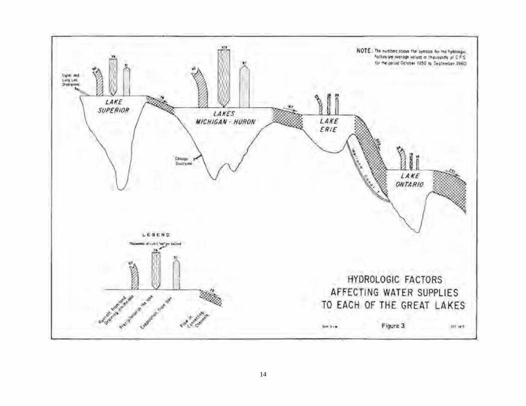
The vast water surface areas of each of theGreat Lakes account for the storage of enormousquantities of water. This unique natural featureabsorbs the large variations in the precipitation fallingdirectly on each lake and the runoff from land draininginto each lake. Consequently the outflow from eachlake is modulated so as to maintain a remarkablysteady discharge to the next lower lake. A schematicprofile of the Great Lakes System, physical data andthe principal hydrologic features of the Great Lakesare presented in Figure 2.
All elevations in this report are based on theInternational Great Lakes Datum-1955 (IGLD-1955).It measures the difference in elevation between thelong-term mean sea level at Father Point, Québec,and any point in the Great Lakes-St. Lawrence RiverSystem. Since there is an extremely slow but positivedifferential vertical movement in the earth's crustwithin the Great Lakes region, it is essential to showthe year in which the datum elevations were assigned.With the passage of time it may be necessary toadjust the reference elevation at a given place toallow for its movement with respect to sea level atFather Point during the intervening period. IGLD-1955is the official datum for the Great Lakes region and isused by United States and Canadian agencies.
The original elevations used in the Commission'sOrders of Approval of May 26 and May 27, 1914 forLake Superior, and Order of Approval of October 29,1952, as amended on July 2, 1956 for Lake Ontariohave been converted to IGLD-1955.
The Great Lakes Basin drains into Lake St.Francis, below the Moses-Saunders Powerhouse at theeasterly end of the International Rapids Section of theSt. Lawrence River. The remainder of the River,entirely within Canada, flows for 430 miles in anortheasterly direction to the Gulf of St. Lawrence andthence to the Atlantic Ocean.
Four major phases of glaciation have formedthe relief and the drainage pattern of the Great LakesBasin. The sediments that mantle the bedrock consistof the glacial drift deposited by the continental icesheets, streams created by melting ice, stratified beds
7

8

laid down in ancient glacial lakes, and dune sandconsisting of glacial materials picked up andredeposited by the wind. These unconsolidated, readilyerodible sediments have been partially reworked bypost-glacial streams and deposited as alluvium in theGreat Lakes, their flood plains and the ConnectingChannels.
Most of the Great Lakes Basin is within twomajor physiographic regions. The areas north and westof Lake Superior and north of Lake Huron are in theLaurentian Uplands dominated by hills, a few lowmountains, many lakes and numerous swamps. Ingeneral this forested region has a shallow overburden.The Central Lowlands cover most of the remainder ofthe Basin. The physiographic relief varies from gentlyrolling to relatively flat topography. The depth of theunconsolidated overburden varies up to 1100 feet. TheAppalachian Plateau borders the southeastern portionof the Basin. It is characterized by a varied relief andprominent escarpments. The eastern limit of the Basinis in the foothills of the Adirondacks. The outlet is inthe wide St. Lawrence Valley which is a relatively flatmarine plain with local rock hills.
The climate of the Great Lakes Basin ismoderated by the influence of the Lakes themselveson the continental air masses that pass through theregion. The average temperature decreases by 10degrees from the Basin's southern to northernextremities, a distance of 750 miles. The warmsummers have frequent hot, humid, tropical periodscaused by air movements from the Gulf of Mexico.Arctic air dominates the region during the winter withmean daily temperatures below freezing from three tosix months. The spring and fall months arecharacterized by the passage of storms through theBasin. Hurricane remnants can pass close to the Basinproducing heavy rains and strong winds. The averageannual precipitation ranges from 26 inches northwestof Lake Superior to 52 inches east of Lake Ontario.Variation from month to month is slight. Snowfallaccounts for 20 to 30 percent of the annualprecipitation depending on the location relative to theopen lakes and also the latitude.
The population within the Great Lakes Basin was35,000,000 in 1970. About 83 percent reside in theUnited States and 17 percent in Canada. One-seventhof the population of the United States lives in the Basinwhich includes four of the twelve largest cities in theUnited States, Chicago, Detroit, Cleveland andMilwaukee. The relative importance in Canada is evengreater because one-third of that country's totalpopulation lives in the Ontario portion of the Basin. Ifthe wholly-Canadian portion of the St. Lawrence RiverBasin is added, the proportion of the total populationrises to 60 percent.
The economy of the Basin is basically industrial.The United States portion of the Basin producesone-sixth of the national income and accounts for overone-fifth of the manufacturing employees and capitalexpenditure. In Canada the figures are more dramaticfor the Basin produces nearly one-third of the nationalincome and accounts for over one-half of themanufacturing employees and capital expenditure. Allthis is due to the fact that the Great Lakes-St. LawrenceRiver System has had the advantage of economical andefficient transportation, access to vast deposits ofnatural resources, cheap power production, moderateclimate and the capacity to receive the wastes from thepopulation and industries it supports.
The region accounts for 40 percent of the UnitedStates iron and steel production and 80 percent of theCanadian output. The Great Lakes ports also serve afurther one-third of the United States steel industry.Similarly, a high proportion of the chemical, paper, foodproducts, machinery, transportation equipment andmetal fabrication industries of both countries are in theBasin.
Agricultural production accounts for sevenpercent of all the United States output and 25 percentof the total Canadian output. There are 59,000 squaremiles of commercial forest in the United States portionof the Basin; over 70,000 square miles in the Canadianportion. The more important minerals produced are ironore and limestone. The scenic shoreline of the GreatLakes, with its opportunities for water-related activitieshas attracted summer resorts and cottages. The valueof the tourist industry in 1971 has been estimated to be$300 million annually in the United States portion of theBasin and $500 million in the Canadian portion.Commercial fishing and sport fishing are alsoeconomically important.
Urban development of the shorelinepredominates in the southern portion of Lake Michiganand around Lakes Erie and Ontario. In Canada aboutone-half of the shoreline, and in the United Statesnearly all the shoreline, is privately-owned. Of the totalshoreline length of 11,200 miles, about 1700 miles areused for recreation, 700 for industrial and commercialpurposes, 2000 for residences, 1600 for agriculture and5200 miles of the shoreline are either forest orundeveloped.
The Great Lakes and their Connecting Channelsand the St. Lawrence River provide a continuous2400-mile deep-draft waterway that extends from theAtlantic Ocean into the heart of the North Americancontinent. The System serves the eight Great Lakesstates, eleven contiguous states and the Canadianprovinces of Ontario, Manitoba and Saskatchewan.Water transportation on the Great Lakes System is notonly vital to the industrial economy of the Basin, but is
9

the link between the agricultural regions of the Westand the consuming areas of the East, as well asseaborne export markets.
Iron ore, coal, limestone and grain account for85 percent of the 220 million tons of water-bornefreight carried each year on the waterway. Theremaining 15 percent includes overseas general cargo,petroleum products, cement and chemicals. Laketraffic movements in the United States compriseshipments of iron ore from western Lake Superior tosouthern Lake Michigan and to Lake Erie, shipments ofcoal from southern Lake Michigan and Lake Erie portsto power plants, municipalities and industries at otherUnited States and Canadian ports, shipments oflimestone from northern Lake Huron and western LakeErie bound for the steel industrial centres, andshipments of grain from western Lake Superior,southern Lake Michigan and western Lake Erie toBuffalo, New York and Canadian ports on the St.Lawrence River. A large portion of the Canadiancommercial transits are on the St. Lawrence Seaway toand from ports on the lower St. Lawrence River. Grainconstitutes the principal cargo downstream and ironore the principal cargo upstream. About one-half of theCanadian wheat exports and 18 percent of the UnitedStates grain exports pass through the Great Lakesports.
The hydro-electric installations in the GreatLakes Basin produce much cheaper power thanthermal plants using fossil or nuclear fuels. Theyproduce far more energy than most otherhydro-electric plants of the same installed capacitybecause the Great Lakes have the unique feature of anextremely high degree of natural regulation. The
existing hydro-electric plants affected by regulation ofthe Great Lakes have a total installed capacity ofnearly eight million kilowatts, of which almost fivemillion are in Canada and over three million are in theUnited States. As the demand for electrical energy inthe Basin continues to increase, the Great Lakes willbecome the principal source of cooling water for fossiland nuclear power plants.
The principal hydro-electric power producers arepublicly-owned utilities. Ontario Hydro and the PowerAuthority of the State of New York generate electricityfrom the Canadian and United States shares of theNiagara River and St. Lawrence River flows. HydroQuebec's Beauharnois-Cedars development in theCanadian portion of the St. Lawrence River utilizes thetotal flow of the River. In addition, there are threesmall hydro-electric plants on the St. Marys River witha total rated capacity of 81 thousand kilowatts. One isa United States Government plant, while the other twoare private utilities, owned by United States andCanadian companies. Besides these installations, otherpublic and private developments are either in place orunderway.
Consideration of further regulation of the levelsof the Great Lakes must give full weight to each of theprincipal factors—shoreline use, the preservation of theecosystem, transportation and power generation. Abalance must be maintained in any modification of thepresent natural regulation or in any changes to existingoperating procedures to ensure fair treatment for allpeople in the Basin as well as those outside it, whomight be affected. Every effort must be made tounderstand as fully as possible the implication ofproposed changes on each interest.
10
Chapter IV
NATURAL FLUCTUATION OF LAKE LEVELS
The vast water surface area of the Great Lakes,combined with the restricted capacities of their outflowchannels, makes them the finest naturally regulatedfresh water system in the world. The normal range ofwater levels from winter lows to summer highs seldomexceeds one and one-half feet. During periods of defi-cient or excessive precipitation lasting several years, theaverage monthly water level, depending on the size ofthe Lake, is from two to three feet below or above thelong-term average. Such gradual, protracted changesare extremely small when they are compared to thefluctuation of water levels on rivers such as theMacKenzie, Red and Colorado, tidal fluctuation of 10 to20 feet at many North American harbours, seasonaldraw-downs of up to 100 feet on large man-madereservoirs, and lakes such as the Arrow Lakes in BritishColumbia, which had a range of 40 feet beforeregulation.
Maximum flows in the Connecting Channels of theGreat Lakes are only two to three times their minimum.This too is remarkable when compared with other largeNorth American waterways. The ratio of maximum andminimum flows of the Mississippi River is 30:1, for theColumbia River 35:1, and the Saskatchewan River 60:1.
The Great Lakes System
Lake Superior is the uppermost lake and with anarea of 31,700 square miles is the largest of the GreatLakes. Lake Nipigon, located within its basin, has awater surface area of 1740 square miles and a drainagearea of 9500 square miles. The St. Marys River, theoutlet from Lake Superior, flows from Whitefish Bay atthe east end of the Lake for 63 miles to Lake Huron.The river drops about 22 feet, of which 0.2 foot occursin the upper 14 miles, 20 feet at the rapids at Sault Ste.Marie, and 2 feet in the lower 48 miles. The water levelsat the foot of the St. Marys Rapids are affected by thewater levels of Lake Huron. The discharge from LakeSuperior is controlled by a gated dam at the head of theSt. Marys Rapids which was built to permit powerdiversions around the rapids while maintaining theregime of water levels on Lake Superior and flow in theSt. Marys River.
Lakes Michigan and Huron, insofar as theirhydraulic characteristics are concerned, are treated asone lake.
Their combined water surface area of 45,300square miles is six times that of Lake Ontario and oneand one-half times that of Lake Superior. The St. Clair
River, at the south end of Lake Huron is the naturaloutlet, although it has been altered by dredging. Thereare no controls that regulate the discharge from LakeHuron. The water from Lake Huron flows for 90 milesdown the St. Clair River, through Lake St. Clair, thencedown the Detroit River to Lake Erie. Total drop betweenLakes Huron and Erie is only eight feet. The watersurface profile in the St. Clair and Detroit Rivers isrelatively uniform and there are no rapids. Furthermore,the water level of Lake Erie has a backwater effect on thelevel of and discharge from Lake Huron.
Lake St. Clair, midway between Lake Huron andLake Erie, has a water surface area of 400 square miles.It is a shallow lake, characterized by a delta in thenorthern portion, a marshy shoreline and adjacent shorelands which are low-lying, flat and subject to inundation.
Lake Erie is the shallowest of the Great Lakes andhas a water surface area of 9900 square miles. Its long,narrow shape and its orientation relative to the prevailingwind and storm patterns, results in frequent and dramaticshort-term changes in the water levels of the Lake.
The uncontrolled, natural outlet from Lake Erie isthe Niagara River. It flows north for 33 miles to LakeOntario. The total drop is 326 feet. The River dropsapproximately 310 feet between the head of the Cas-cades, immediately upstream from the Niagara Falls andthe Lower Rapids, six and one-half miles downstream,with a sheer drop of 170 feet occurring at the Fallsthemselves.
Sixteen miles downstream from Lake Erie andimmediately upstream from Niagara Falls is a gatedstructure which extends from the Canadian shoreline tothe centre of the River. Its purpose is to maintain thenatural levels of the Grass Island Pool and provide properdistribution of flow over the Horseshoe and AmericanFalls, while allowing for the diversion of water to thehydro-electric power plants. This structure cannotregulate the levels of Lake Erie because the natural bedrock weir at the head of the Niagara River controls theoutflow from that Lake.
In addition to the flows over Niagara Falls, waterfrom Lake Erie reaches Lake Ontario by way of powerdiversions from the Niagara River just above the Falls,the Welland Canal and New York State Barge Canal. Theaverage flow of the Niagara River is 202,000 cfs. TheNiagara Treaty of 1950 provides for a minimum flow of100,000 cfs over the Niagara Falls during the daylighthours of the tourist season and a minimum flow of50,000 cfs at all other times. All water in excess of Treatyrequirements is available for power production. An
11

average flow of 7000 cfs is diverted through theWelland Canal for navigation and the generation ofhydro-electricity at DeCew Falls. About 700 cfs isdiverted from the Niagara River to the New York StateBarge Canal and is returned to Lake Ontario at fourlocations.
Lake Ontario is the smallest of the Great Lakes.It has a water surface area of 7600 square miles. Mostof the shoreline is composed of unconsolidatedsediments, deposited by retreating glaciers, althoughhard limestone formations characterize the northeasternportion.
The St. Lawrence River at the northeast end ofLake Ontario is the natural outlet for the Great Lakes.Numerous rocky islands and reefs dominate the broadchannel of the River for the first 67 miles. This part ofthe International Rapids Section of the St. LawrenceRiver is known as the Thousand Islands. The Riverchannel then narrows abruptly as it crosses the hardrock protusion of the Canadian Shield and flows downthe International Rapids Section.
Approximately 100 miles downstream from LakeOntario is the Moses-Saunders Powerhouse whichutilizes the flow and the 80-foot drop into Lake St.Francis of the International Rapids Section of the St.Lawrence River. It is used to regulate the dischargefrom Lake Ontario. Nearby is Long Sault Dam which isused to pass excess river flows during periods of highwater or a shut-down of turbines in the powerhouse.About 27 miles upstream from the powerhouse isIroquois Dam which may be used to moderate waterlevel fluctuations on Lake St. Lawrence and assist in theformation of a stable ice cover.
The remainder of the St. Lawrence River isentirely in Canada. From Lake St. Francis it flowsthrough the Beauharnois Power and Navigation Canaland also down the Coteau Rapids to Lake St. Louis,thence down the Lachine Rapids to the Laprairie Basinat Montreal, a distance of thirty-five miles, for a totaldrop of 132 feet. The River then flows through the St.Lawrence lowlands to Lake St. Peter and finally to theGulf of St. Lawrence, a distance of 350 miles with adrop of only 20 feet.
The Hydraulics of the Great Lakes
The natural outlets from Lakes Michigan-Huronand Lake Erie are not regulated by any artificial devices.The discharge from Lake Huron is controlled by thelevel of that lake, the size and characteristics of itsoutlet channel, the St. Clair and Detroit Rivers, and thelevel of Lake Erie. The natural discharge from Lake Erieis controlled by its own level and the natural outlet atthe head of the Niagara River.
The discharge from Lakes Huron and Erieincreases as the water level at the entrance to their
outlet channels rises. However the physical dimensions ofthe Connecting Channels restrict their response to higheror lower water levels, thus limiting changes in the outflowto the lower lake. For example, the discharge through theSt. Clair River is increased by only 6,000 cfs or threepercent when the water level rises 0.4 foot. However, tocreate that 0.4 foot rise and 6,000 cfs increase inoutflow, Lakes Michigan-Huron storage must beincreased by an amount equivalent to the total volume ofwater discharged through the St. Clair River for onemonth at a continuous rate of 188,000 cfs whichamounts of 3.4 cubic miles of water. This vividly illus-trates the regulating effect of the Connecting Channels.
The water supply from Lake Superior to LakesMichigan-Huron is fairly uniform due to regulation.However, the precipitation combined with theevaporation in the Michigan-Huron Basin variesconsiderably. Consequently the local water supply tothese Lakes has fluctuated tremendously from amaximum of 496,000 cfs for one month to a minimum of-193,000 cfs for one month, a range of 689,000 cfs. Thenegative minimum indicates that evaporation from thelake surface exceeded the rainfall and local runoff to thatlake.
In the face of these extreme local supplyvariations, should it be desired to maintain Lakes Huronand Michigan near a constant level, two canals the size ofthe Detroit River would be required in addition to theexisting River to provide sufficient outflow capacity duringperiods of high supply. These canals would have to beequipped with control gates to reduce the outflow duringperiods of low supply. One canal would likely follow aroute from Port Huron through the residential andindustrial areas of Macomb and Wayne Counties in theUnited States to Lake Erie, while the other might followa route from Sarnia through the highly productiveLambton and Kent Counties in Canada to Lake Erie.During periods of excessive precipitation, these canalswould carry full flow while during times of deficientprecipitation there would be no flow. Downstreaminterests can be thankful that nature does not release thewaters from Lake Huron in such a way as to maintain aconstant lake level. Such regulation would at times floodthe downstream inhabitants and at other times eliminateinflows to the lower lakes.
In striving to better the works of nature, man mustrecognize the full consequences of his acts and beprepared to control the forces he attempts to redirect.
The levels of Lake Superior and Lake Ontario areregulated within the limits of their controls and thecapacities of their outlet channels. The outflows of theselakes are not unlimited. The outflow capacity from LakeSuperior was increased by man so that it is nowapproximately 130,000 cfs when the level of LakeSuperior is at its historical peak, when the diversions tohydro-electrical plants are at their maximum and when all
12

gates of the compensating works are open. Similarly, itis not only the control works in the International RapidsSection of the St. Lawrence River that limit themaximum discharge from Lake Ontario but also thephysical characteristics of the River and the level ofLake Ontario that dictates the maximum outflow.
As previously mentioned, the natural restrictionsof the Connecting Channels combined with the vastwater surface area of the Great Lakes tend to smoothout the erratic extremes of precipitation andevaporation and result in a naturally well-regulatedoutflow. The hydraulics of the Great Lakes System issuch that the change in flow to the next lower lake issmall compared to the change in storage and supplyconditions. When either high or low water suppliesoccur for an extended period the correspondingextremes of water levels persist for several years afterthe climatic conditions have changed.
For example, it takes two and one-half years foronly fifty percent of the full effect of change in watersupply to Lake Huron to be realized in the outflows fromLake Ontario; and three and one-half years for sixtypercent of the full effect to be realized. In other words,the Lower Lakes may suffer from abnormal low or highlevels long after the Upper Lakes have returned tonormal conditions. Regulation would be much morebeneficial to all interests if reasonable water supplyforecasts could be made, not for several months ahead,but for two or three years ahead. However, it is thepresent consensus of international weather experts thatsuch long-range forecasts will not likely be available inthe foreseeable future. Nevertheless a careful watchshould be kept on the changing technology in this field.
Hydrology of the Great Lakes
The levels of each of the Great Lakes are theresult of an integration of the hydraulic characteristicsof the Connecting Channels and the St. Lawrence Riverand the total water supply received by each Lake. Thetotal water supplies are the inflows from the upper lake,plus runoff from the land draining into that particularlake, plus precipitation falling directly on the watersurface less the evaporation from that lake.
These hydrologic factors are the dominant causeof the protracted fluctuations in the levels of the GreatLakes. They are shown graphically in their properproportions in Figure 3. The numbers are an averagefor a ten-year period which includes both high andnormal water supplies.
The level of each of the Great Lakes depends onthe balance between the total water supplies received
by that lake and its discharge to the next lower lake. Ifthe water supplies received by the lake are greater thanthose discharged, its level gradually rises. Conversely,if the water supplies are less than the discharge, thelake level slowly drops.
Precipitation in the form of rain and snow is thesource of all water supplies to the Great Lakes. The lowlake levels during the mid-1930's and 1960's were theresult of abnormally low precipitation, while the high lakelevels of the early 1950's and 1970's were caused byexcessive precipitation.
The minimum and maximum average annualprecipitation for each of the five drainage basins areshown on Figure 2 in Chapter III. It should be noted thatthe annual precipitation in the Lake Superior Basin hasvaried from 24.0 to 38.0 inches, Lake Michigan Basin22.2 to 37.8 inches, Lake Huron Basin from 25.8 to 39.0inches, Lake Erie Basin from 24.5 to 42.6 inches and inthe Lake Ontario Basin the annual precipitation hasvaried from a low of 27.6 inches to a high of 43.7 inches.
Precipitation on the land surfaces moves throughseveral storages. During freezing weather it accumulatesas snow. Water from snowmelt or rain either seeps intosoil as temporary groundwater storage or moves over thesurface as runoff to streams, swamps and lakes. The landrunoff to the Great Lakes is the highest during the springsnowmelt. The gradual recession of land runoff until fallor the next spring is due to the release of watertemporarily stored in swamps, small lakes and the sub-surface which sustains stream flow during the drierweather of summer and fall.
The peak runoff occurs in May in Lake Superior,April on Lakes Michigan-Huron, March on Lake Erie andApril on Lake Ontario. Lakes Erie and Ontario often havehigher runoff from their basins during the fall and winteras a result of rainfall and snowmelt during these monthswhen land evaporation and transpiration is least andwhen the subsoil is either saturated or frozen. Such wasthe case in 1972.
The higher levels of the Great Lakes in the springand early summer and a gradual lowering of levels duringthe remainder of the year are due to the hydrologiccharacteristics of each basin. The seasonal fluctuation oflake levels reflects the variations of runoff to, andevaporation from, each basin. In any given year thevariations from winter lows to summer highs are small,averaging about one foot on Lakes Superior, Michiganand Huron, one and one-half feet on Lake Erie and nearlytwo feet on Lake Ontario.
Evaporation from the land and water surfaces isdependent on solar radiation, temperature of the airmass and water, humidity and wind. On the long-term
13
14

average over half of the precipitation on land surfacesis lost to the atmosphere through evaporation andtranspiration. When the air above the lakes is warm andmoist and the lakes are cold, as in the spring,evaporation is least. In the fall and early winter, whenthe air above the lakes is dry and the lakes arerelatively warm, evaporation is the greatest.
Evaporation is always reduced considerablyduring periods of excessive precipitation. This is causedby a marked reduction in solar radiation and coolertemperatures due to increased cloud cover and aresulting high humidity. These hydrologic characteristicsaccentuate the problem of high lake levels by reducingthe amount of water lost to the atmosphere during aperiod of high precipitation and runoff. Conversely,evaporation is greater during drought conditions. Thesenatural phenomena are the dominant causes of thelong-term fluctuations of the Great Lakes. Their
duration and recurrences cannot even be predicted,much less controlled by man.
The mean monthly levels for each of the GreatLakes since 1860 are shown in Figures 4 and 5. Theyrecord the long-term and annual fluctuations that haveoccurred in the last 116 years.
The amount of water furnished to a given lakefrom its own basin is the ultimate response to changesin precipitation and evaporation. The changes not onlyvary seasonally but also from year to year. Table 1illustrates the magnitude of the variations of themonthly net basin supplies. It should be noted that thenet basin supplies do not include inflow from the upperlake or diversions into or out of that particular lake. Athousand cfs months is the volume of water that in onemonth flows past a point at the rate of 1,000 cubic feetper second. This is equivalent to the amount of waterrequired by a city of 450,000 people for one year.
Table 1- MONTHLY NET BASIN SUPPLIES in cfs monthsLake Average Maximum Minimum RangeSuperior 71,000 354,000 -100,000* 454,000Michigan-Huron 110,000 496,000 -193,000* 689,000Erie 21,000 182,000 - 73,000* 255,000Ontario 34,000 164,000 - 22,000* 186,000
* Negative values indicate that the evaporation rate from the lake surface exceeds the amount of water supplied to the lake.
The variations shown in Table 1 of the watersupplies furnished by each basin to the Great LakesSystem when compared to the long-term variations inwater levels shown on Figures 4 and 5 demonstratehow nature has regulated its own erratic extremes.However, the high water supplies to any one of theGreat Lakes can only be stored temporarily. Eventuallyall water is discharged to the next lower lake andaugments its local supply. It can take as long as 15years for the full effect of supply changes to berealized in the lower lakes.
The long-term fluctuations in the levels of theGreat Lakes are the direct result of a number of yearsof excessive or deficient precipitation. Their magnitudeand duration is irregular and for this reason high andlow water levels do not occur in any regular cycles.Superimposed upon the hydro-electric fluctuations arethe inevitable annual fluctuations caused by seasonalvariations in water supply. These tend to exaggeratethe long-term fluctuations.
Fluctuations Due to Storms
The most dramatic changes in water levels arethe short-term fluctuations caused by strong winds andby sharp differentials in barometric pressure. They
usually are of short duration, lasting less than one day,and do not represent any changes in the volume of waterin the lake.
The winds are caused by the passage of weathersystems. The strong winds which cause most of theshoreline damage occur primarily in the spring and fall.Winds keep the water surface of the Great Lakes inconstant motion and influence the littoral currents whichbuild and destroy the beaches.
During periods of strong winds, deep water wavesgenerated by the wind can reach a height in excess of 25feet from trough to crest. It is the energy released bythese waves as they break on the shore that causeserosion. When superimposed on high water levels, thedamage caused by waves is increased. This is illustratedon Figure 6.
Strong winds tend to build up the level at the down-wind shore and reduce the water level along the upwindshore. A sustained high wind along the southwesterly axisof Lake Erie has caused the water level at Buffalo to riseeight feet. Also, strong winds have caused a similar effecton Lake Ontario in the order of two feet. Movement ofweather systems can produce local changes inatmospheric pressures which in turn cause suddenchanges in water levels.
15
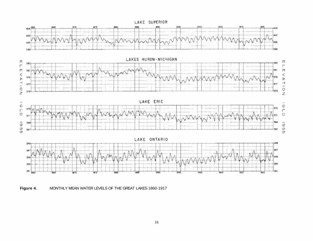
Figure 4. MONTHLY MEAN WATER LEVELS OF THE GREAT LAKES 1860-1917
16

Figure 5. MONTHLY MEAN WATER LEVELS OF THE GREAT LAKES 1918-1975
17
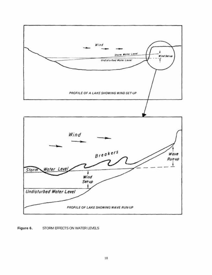
Figure 6. STORM EFFECTS ON WATER LEVELS
18

In summary, the principal cause of long-termfluctuations on the Great Lakes is extended periods ofexcessive or deficient precipitation. The regular annualfluctuation in levels are due to the seasonal variation inwater supplies. The short-term fluctuations are theresult of wind and meteorological disturbances. None ofthese natural factors can be controlled by works of man.
Other Natural Fluctuations
A number of other natural phenomena causefluctuations in the water levels of the Great Lakes. Icejams in the Connecting Channels and the St. LawrenceRiver have retarded the outflow from the lakeimmediately upstream. Similarly, aquatic weed growth inthe outlet rivers has reduced their discharge. Crustalmovement and tides cause a minor change in waterlevels.
The formation of an ice cover and ice jamsmaterially reduce the flow in the outlet rivers during theperiod from January to March. The natural reduction inflow raises the level on the upstream lake and increasesits storage. Thus the levels of the lakes are higher at thetime of the spring breakup than they would be underice-free conditions. Neither the timing or severity of iceconditions are predictable.
Historical data indicate that ice jams have reducedthe outflow from Lakes Michigan-Huron by as much asfifty percent. The estimated average reduction in flow ofthe St. Clair River from January through March due toice conditions is 19,000 cfs. The long-term effect of iceconditions has increased the average level of LakesMichigan-Huron by 0.4 foot. Ice jams on the natural rockbarrier at the outlet from Lake Erie have materiallyreduced the flow in the Niagara River. The averagereduction during the winter months is estimated to be4,000 cfs. A similar situation exists on the Upper St.Lawrence River. Its recorded minimum flow was thedirect result of large ice jams caused by the breakup ofthe ice cover on the River.
The retardation of flow due to ice conditions onthe Niagara River has been reduced since the installationof the Lake Erie-Niagara River ice boom commencing inthe winter of 1964-65. The annual installation of icebooms in the Upper St. Lawrence River has significantlyincreased the winter discharge from Lake Ontario. Thisis particularly important during periods of high waterlevels. The ice booms are installed in the late fall andremoved when the ice formations on Lake Erie and theSt. Lawrence River dissipate. These ice booms accelerateand assist in the formation and maintenance of a stableice cover. They have successfully reduced ice jamswhich cause shoreline damage and curtail the generationof electric power.
Aquatic growth in the rivers reduces the outflowfrom the lake immediately upstream. This in turn causes
a small natural increase in the lake level. The retardationin discharge generally starts in May, reaches a maximumin July, and becomes insignificant in November. Thedegree of retardation varies from river to river and fromyear to year. Retardation of flow in the Niagara due toaquatic growth has been under close observation. Acomparison of discharge curves indicates that aquaticgrowths have reduced the outflow from Lake Erie by asmuch as 10,000 cfs.
Crustal movement has a minor but permanenteffect on the levels of the Great Lakes. The weight ofglaciers depressed the earth's crust into the weakerlayers below. As the glaciers retreated the earth's crustbegan to rebound in a process somewhat similar to therebound of a cushion following the removal of a weight.For thousands of years in the Great Lakes Basin therehas been a continuous differential uplift of the earth'scrust. Geologists have determined that an uplift ofseveral hundred feet has occurred in some areas alongthe shorelines of the Great Lakes. It appears that theland along the northern and eastern shores of the lakesis rising with respect to the southern and westernshores.
Consequently the water levels along the shorelinesituated to the west and south of the outlet from eachlake are rising higher with respect to the water level atthe outlet. For example, it has been estimated that theearth's crust at the outlet from Lake Superior is risingtwelve inches per century while the earth's crust atDuluth is only rising four and one-half inches. AtThunder Bay the estimated rise per century is fifteeninches. Therefore, the water level at Duluth is risingseven inches per century with respect to the outlet fromLake Superior, while the water level at Thunder Bay isdropping three inches per century. Similarly, thedifferential rise in the earth's crust between Buffalo andCleveland is three inches.
Also the earth's crust at the outlet from LakeOntario is estimated to be rising nine inches more percentury than the earth's crust at Hamilton and six inchesmore than the earth's crust at Rochester. Therefore, thewater level at Hamilton is rising nine inches per centurywith respect to the outlet from Lake Ontario while waterlevel at Rochester is rising six inches per century. Theseminor but inevitable effects on water levels must beconsidered in locating permanent structures and indesign of regulation plans.
The magnitude of both solar and lunar tides thatoccur on the Great Lakes is small. The spring tide whichis a combination of the largest solar and largest lunartide is reported to be less than two inches on LakeSuperior, the largest of the Great Lakes.
Data are not available to estimate the quantity ofgroundwater flowing into or from any of the GreatLakes. However, it is believed that the effects areinconsequential.
19

Chapter V
MAN'S INTERVENTIONS
Throughout the last 150 years, man hasprogressively intervened in the natural regime of theGreat Lakes System. The rapid economic growth in theBasin is a consequence of continuous improvement inthe waterways throughout the system, the developmentof hydroelectric potential and the availability of freshwater to meet all industrial and municipal requirements.The regulation of Lake Superior and Lake Ontario isdescribed in Chapter VI. This chapter discusses
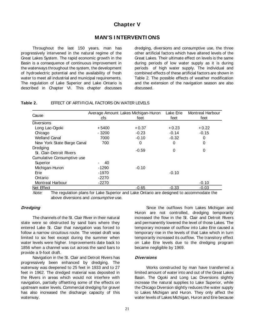
dredging, diversions and consumptive use, the threeother artificial factors which have altered levels of theGreat Lakes. Their ultimate effect on levels is the sameduring periods of low water supply as it is duringperiods of high water supply. The individual andcombined effects of these artificial factors are shown inTable 2. The possible effects of weather modificationand the extension of the navigation season are alsodiscussed.
Table 2. EFFECT OF ARTIFICIAL FACTORS ON WATER LEVELS
Cause Average Amountcfs
Lakes Michigan-Huronfeet
Lake Eriefeet
Montreal Harbourfeet
Diversions Long Lac-Ogoki +5400 +0.37 +0.23 +0.22 Chicago - 3200 -0.23 -0.14 -0.15 Welland Canal 7000 -0.10 -0.32 0 New York State Barge Canal 700 0 0 0Dredging St. Clair-Detroit Rivers -0.59 0 0
Cumulative Consumptive use Superior - 40 Michigan-Huron -1290 -0.10 Erie -1970 -0.10 Ontario -2270 Montreal Harbour -2270 -0.10Net Effect -0.65 -0.33 -0.03Note: The regulation plans for Lake Superior and Lake Ontario are designed to accommodate the
above diversions and consumptive use.
Dredging
The channels of the St. Clair River in their naturalstate were so obstructed by sand bars where theyentered Lake St. Clair that navigation was forced tofollow a narrow circuitous route. The vessel draft waslimited to six feet except during the summer whenwater levels were higher. Improvements date back to1856 when a channel was cut across the sand bars toprovide a 9-foot draft.
Navigation in the St. Clair and Detroit Rivers hasprogressively been enhanced by dredging. Thewaterway was deepened to 25 feet in 1933 and to 27feet in 1962. The dredged material was deposited inthe Rivers in areas which would not interfere withnavigation, partially offsetting some of the effects onupstream water levels. Commercial dredging for gravelhas also increased the discharge capacity of thiswaterway.
Since the outflows from Lakes Michigan andHuron are not controlled, dredging temporarilyincreased the flow in the St. Clair and Detroit Riversand permanently lowered the level of those Lakes. Thetemporary increase of outflow into Lake Erie caused atemporary rise in the levels of that Lake which in turntemporarily increased its outflow. The transitory effecton Lake Erie levels due to the dredging programbecame negligible by 1969.
Diversions
Works constructed by man have transferred alimited amount of water into and out of the Great LakesBasin. The Ogoki and Long Lac Diversions slightlyincrease the natural supplies to Lake Superior, whilethe Chicago Diversion slightly reduces the water supplyto Lakes Michigan and Huron. They only affect thewater levels of Lakes Michigan, Huron and Erie because
21

the Lake Superior and Lake Ontario regulation planstake account of these constant diversions. The WellandCanal through which some of the outflow from LakeErie bypasses the Niagara River, slightly lowers thelevels of the unregulated lakes. The New York StateBarge Canal diversion, withdrawn from the NiagaraRiver, has virtually no effect on the lakes.
The operation of the present Long Lac and OgokiDiversions commenced in 1939 and 1943, respectively.They divert water into the Lake Superior Basin from theAlbany River Basin, which under natural conditionswould flow into the Hudson Bay. The sum of thesediversions has averaged about 5400 cfs. This amountrepresents seven percent of the average outflow fromLake Superior and two and one-half percent of theoutflow from Lake Erie. During the early years of WorldWar II, the United States agreed that Canada couldutilize 5000 cfs of the water diverted from the AlbanyBasin at Niagara Falls. The notes exchanged betweenthe two Governments in 1940 concerning this subjectwere confirmed in Article III of the Niagara Treaty of1950, and are included in Appendix H of this report.
The Long Lac Diversion consists of a concreteoverflow dam on the Kenogami River which diverts thenatural flow into Long Lac. From there it flows througha five-mile channel built across the continental divide toconvey the water from Long Lac to the AguasabonRiver, a tributary to Lake Superior. There is a concreteregulating dam at the south end of this channel. Since1940 an average of 1400 cfs has been diverted intoLake Superior. The remainder of the water supply toLong Lac has been spilled down the Kenogami River toHudson Bay. The diverted water is used to generateelectricity at a power plant near the mouth of theAguasabon River.
The Ogoki Diversion transfers water from theOgoki River into Lake Nipigon which is within the LakeSuperior Basin. It augments the natural water supply toLake Nipigon. Waboose Dam on the Ogoki River raisesthe water level so that most of the flow is redirectedacross the summit, through a chain of small lakes toLittle Jackfish River, and thence into Lake Nipigon. Adam at the summit controls the amount of water thatis diverted. The diversion has varied from zero to16,000 cfs with a long-term average of 4000 cfs. Forvarious reasons, the diversion has been closed orreduced over 25 times since it began operation in 1943.Lake Nipigon has a water surface area of 1740 squaremiles and a prescribed operating range of nearly sevenfeet. The average local inflow into Lake Nipigon,excluding the diversion, is 8900 cfs. The outflow iscontrolled by a powerhouse at Pine Portage, the upper-most of three hydro-electric plants on the NipigonRiver. A minimum outflow of 8000 cfs is required sothat the Town of Nipigon, located on a wide reach of
the Nipigon River, can obtain its water supply. Flows inexcess of 20,000 cfs endanger the railway and highwaybridges at Nipigon.
During the high water period of 1951-53, OntarioHydro voluntarily reduced the quantity of water divert-ed from the Ogoki River. For several months in each ofthose years diversions were stopped. Ontario Hydroagain reduced diversions during the high water supplyperiod of 1972-74. The outflow from Lake Nipigon waslimited to its natural local inflow. All of the waterdiverted from the Ogoki River was stored in LakeNipigon to be released to Lake Superior at a later date.When its level reached the upper limit in 1974, thediversion from the Ogoki was stopped. An average of13,000 cfs was directed to the north for three months.
The Chicago Diversion has transferred waterfrom Lake Michigan into the Mississippi River Basinsince 1848. Water is diverted at three locations: AtWilmette through the North Shore Channel into thenorth branch of the Chicago River; at Chicago throughthe Chicago River which is closed by a lock to preventflow from the River entering Lake Michigan; and atCalumet Harbour through the Calumet River and thechannel into the Sanitary and Ship Canal. The primarypurpose of the diversion is to dilute the sewage effluentof the Chicago Sanitary District and divert it into theMississippi River Basin. The Chicago Sanitary and ShipCanal is also used for navigation. The diverted water isused by hydro-electric plants at Lockport andMarseilles, Illinois.
Effective March 1, 1970, by a decree of theUnited States Supreme Court dated June 12, 1967, themaximum allowable diversion from Lake Michigan atChicago is 3200 cfs, including domestic pumpage. Acopy of the Decree is in Appendix I.
The original eight-foot Welland Canal wasopened in 1829. It was the first complete navigable linkbetween Lakes Erie and Ontario. Since then the canalhas undergone several enlargements. The WellandCanal connects Lake Erie at Port Colborne, Ontarioabout 18 miles west of the head of the Niagara River,with Lake Ontario at Port Weller, Ontario. It presentlydiverts an average of 7000 cfs for navigation and forgeneration of power at DeCew Falls Power Plant on theNiagara Escarpment. By increasing the naturaldischarge from Lake Erie, the Welland Canal haslowered the water level of Lake Erie and slightlylowered the levels of Lakes Michigan and Huron.
The New York State Barge Canal system divertswater from the Niagara River at Tonawanda, New York.The average diversion is about 700 cfs. Its primary useis for the operation of the Erie Canal. The water isultimately discharged into Lake Ontario through severaltributary streams as far east as Oswego, New York.
22

Consumptive Use
Consumptive use is that portion of the water,withdrawn or withheld from the Great Lakes Basin, andnot returned to it. Consumptive use includes waterused by crops through irrigation, incorporated intomanufactured products, lost by industrial processes andthermal power generation.
The consumptive use of water in any one lakebasin not only reduces the net water supply to thatlake, but also reduces the water supply to all thedownstream lakes. Consumptive use of water is a directresult of increased evaporation and transpiration.
Water is needed for the production of thermalpower. Of an estimated withdrawal of 33,700 cfs forcooling purposes, approximately 180 cfs is lost byevaporation. The consumptive use for irrigation isabout 145 cfs. Industry withdraws about 16,500 cfsand consumptively uses 660 cfs. Withdrawal of waterfor municipal and rural use is about 7700 cfs. All but1285 cfs is returned to the Great Lakes. The totalpresent consumptive use of water in the Great LakesBasin is estimated to be 2770 cfs. It is expected thatthe consumptive use of water will rise to 6000 cfs inthe year 2000 and to 13,000 cfs by the year 2030. Thiswill lower the levels of all the Great Lakes.
Navigation Season Extension
Extension of the navigation season on the GreatLakes may influence lake levels by affecting outflowthrough the Connecting Channels.
The frictional effect of winter ice cover causes areduction in outflow. The ice cover, by insulating the
flowing water from the frigid air, reduces theproduction of ice. Opening the channel in winter couldincrease winter outflows and therefore lower levels inthe upper lake, and increase levels downstream.Conversely, ice broken by ship passages in the channelmay create jams causing significant reduction inoutflows with resulting higher levels upstream andlower levels downstream. Such changes can alsoseriously affect supplies to municipal and industrialintakes and to power plants.
The Commission cannot specify at present theexact effects that winter navigation may have, but it isconcerned about the possible hazards.
Weather Modification
Weather modification may in time affect the totalsupplies of water to the Great Lakes Basin. It could dothis by simply increasing the total precipitation withinthe Basin. It could also reduce the total precipitation byincreasing precipitation outside the Basin before airmasses enter the Basin. A different effect could arisewithin the Basin by increasing precipitation in thedrainage area of one lake either with or without acorresponding decrease in another drainage area.
The significance of the effect of such changeswould depend on their timing and magnitude. At thepresent time, it is not considered likely that weathermodification programs on a scale large enough to affectthe flow and level patterns of the Great Lakes will beundertaken in the near future. Nevertheless a watchwill be necessary to identify national or internationalprograms which might have significant effects in thisarea.
23


Chapter VI
PRESENT REGULATION
Man has modified the outflows of Lake Superiorand Lake Ontario by slightly altering the sequence andmagnitude of their releases. Within limits he hasattempted to control the levels of Lake Superior since1921 and those of Lake Ontario since 1960.
The regulation of Lakes Superior and Ontariorequired an enlargement of their outlet channels toallow an increase in the discharge capacity and theprovision of gated structures to allow reduction in out-flows. Since long-term weather forecasting techniquesare not sufficiently advanced, one must rely onhistorical hydrological data to devise regulation rulesand indices to estimate the probable water supply. Theregulation of Lake Superior and Lake Ontario requiresthe aplication of prescribed rules to manage the variablewater supplies so as to meet the conditions set forth inthe Commission's Orders of Approval.
The purpose of these rules is to provide levelsand flows that result in generally beneficial conditionswithout unacceptable adverse effects on any oneinterest. Regulation rules which will achieve themaximum need of any one interest without infringingupon other established interests cannot be prescribed.The difficulties of devising regulation rules that providebeneficial conditions to all interests on all of the GreatLakes at all times are further compounded byunprecedented water supplies and severe storms. Atthe very best such rules may only partially achieve theirobjectives.
Lake Superior Regulation
The natural regime of the St. Marys Rapids hascontinually been changed since 1822 when the UnitedStates Army built a raceway and sawmill. The first shipcanal was constructed by the State of Michigan in 1855.The United States Government in 1871 started enlarge-ment of the navigation canal, which became federalproperty in 1881. Improvements continued until therewere four locks in operation. The International RailwayBridge was completed by 1887. The canal on the UnitedStates side of the rapids, now known as the UnitedStates Power Canal, was completed in 1893. Thesecond United States canal, now known as the EdisonSault
Power Canal was completed in 1902. On theCanadian side the navigation canal and lock and theGreat Lakes Power Canal began operation in 1895. The
bridge pier and approaches and the navigation canalsreduced the width of the rapids. However, the powercanals increased the amount of water that could bedischarged from Lake Superior. This increased flowcapacity necessitated the construction of control worksto compensate for the increased outflow capacity fromLake Superior through the power canals.
In 1914 the Algoma Steel Corporation Limited ofthe Province of Ontario and the Michigan NorthernPower Company of the State of Michigan applied tothis Commission for approval to build compensatingworks at the head of St. Marys Rapids. At that timefour of the ten spans of the International Bridge wereavailable for free flow, three spans were across theheadrace of the United States power plant, one spanhad been replaced by a fill at the United States end ofthe bridge, and four gates of the compensating workshad been constructed about 150 feet upstream fromthe bridge in front of two spans on the Canadianshoreline. In addition there were the Great LakesPower Canal, the Canadian and United Statesnavigation canals and St. Marys Power Canal, nowknown as the Edison Sault Power Canal. The outflowfrom Lake Superior was at that time unregulated.
Construction and operation of the controlstructure just above the head of the St. Marys Rapidswas approved by the International Joint Commissionin its first Orders of Approval dated May 26 and 27,1914. An office consolidation of these two Orders is inAppendix F. The control structure consisting ofmasonry piers and sixteen hand-operated Stoneysluice gates 52 feet wide. was completed in 1921.
The Commission's Orders provide that thecompensating works and power canals be operated soas to maintain the level of Lake Superior "as nearly asmay be" between elevation 600.5 and 602.0IGLD-1955 and in such a manner as not to interferewith navigation. To guard against unduly high stagesof water in the lower St. Marys River, the Orderrequired that the discharge from Lake Superior berestricted so that the elevation of the water surfacebelow the locks is not greater than 582.9 feet. TheCommission established the International LakeSuperior Board of Control to supervise the operation ofall control works, canals, headgates and bypasses andto formulate rules for their operation. The existingcontrol works at the head of the St. Marys Rapids areshown on Figure 7.
25

26

Figure 8. REGULATION OF LAKE SUPERIOR
27
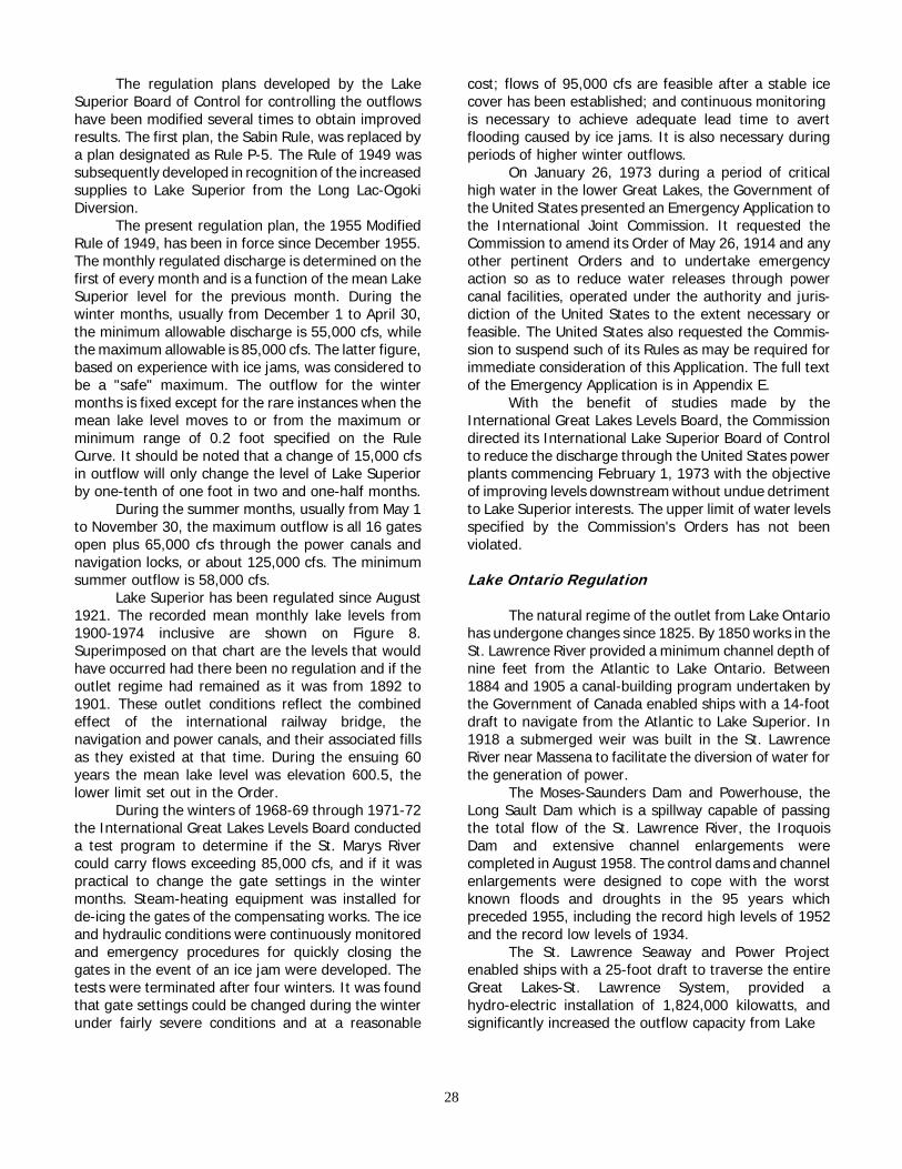
The regulation plans developed by the LakeSuperior Board of Control for controlling the outflowshave been modified several times to obtain improvedresults. The first plan, the Sabin Rule, was replaced bya plan designated as Rule P-5. The Rule of 1949 wassubsequently developed in recognition of the increasedsupplies to Lake Superior from the Long Lac-OgokiDiversion.
The present regulation plan, the 1955 ModifiedRule of 1949, has been in force since December 1955.The monthly regulated discharge is determined on thefirst of every month and is a function of the mean LakeSuperior level for the previous month. During thewinter months, usually from December 1 to April 30,the minimum allowable discharge is 55,000 cfs, whilethe maximum allowable is 85,000 cfs. The latter figure,based on experience with ice jams, was considered tobe a "safe" maximum. The outflow for the wintermonths is fixed except for the rare instances when themean lake level moves to or from the maximum orminimum range of 0.2 foot specified on the RuleCurve. It should be noted that a change of 15,000 cfsin outflow will only change the level of Lake Superiorby one-tenth of one foot in two and one-half months.
During the summer months, usually from May 1to November 30, the maximum outflow is all 16 gatesopen plus 65,000 cfs through the power canals andnavigation locks, or about 125,000 cfs. The minimumsummer outflow is 58,000 cfs.
Lake Superior has been regulated since August1921. The recorded mean monthly lake levels from1900-1974 inclusive are shown on Figure 8.Superimposed on that chart are the levels that wouldhave occurred had there been no regulation and if theoutlet regime had remained as it was from 1892 to1901. These outlet conditions reflect the combinedeffect of the international railway bridge, thenavigation and power canals, and their associated fillsas they existed at that time. During the ensuing 60years the mean lake level was elevation 600.5, thelower limit set out in the Order.
During the winters of 1968-69 through 1971-72the International Great Lakes Levels Board conducteda test program to determine if the St. Marys Rivercould carry flows exceeding 85,000 cfs, and if it waspractical to change the gate settings in the wintermonths. Steam-heating equipment was installed forde-icing the gates of the compensating works. The iceand hydraulic conditions were continuously monitoredand emergency procedures for quickly closing thegates in the event of an ice jam were developed. Thetests were terminated after four winters. It was foundthat gate settings could be changed during the winterunder fairly severe conditions and at a reasonable
cost; flows of 95,000 cfs are feasible after a stable icecover has been established; and continuous monitoring is necessary to achieve adequate lead time to avertflooding caused by ice jams. It is also necessary duringperiods of higher winter outflows.
On January 26, 1973 during a period of criticalhigh water in the lower Great Lakes, the Government ofthe United States presented an Emergency Application tothe International Joint Commission. It requested theCommission to amend its Order of May 26, 1914 and anyother pertinent Orders and to undertake emergencyaction so as to reduce water releases through powercanal facilities, operated under the authority and juris-diction of the United States to the extent necessary orfeasible. The United States also requested the Commis-sion to suspend such of its Rules as may be required forimmediate consideration of this Application. The full textof the Emergency Application is in Appendix E.
With the benefit of studies made by theInternational Great Lakes Levels Board, the Commissiondirected its International Lake Superior Board of Controlto reduce the discharge through the United States powerplants commencing February 1, 1973 with the objectiveof improving levels downstream without undue detrimentto Lake Superior interests. The upper limit of water levelsspecified by the Commission's Orders has not beenviolated.
Lake Ontario Regulation
The natural regime of the outlet from Lake Ontariohas undergone changes since 1825. By 1850 works in theSt. Lawrence River provided a minimum channel depth ofnine feet from the Atlantic to Lake Ontario. Between1884 and 1905 a canal-building program undertaken bythe Government of Canada enabled ships with a 14-footdraft to navigate from the Atlantic to Lake Superior. In1918 a submerged weir was built in the St. LawrenceRiver near Massena to facilitate the diversion of water forthe generation of power.
The Moses-Saunders Dam and Powerhouse, theLong Sault Dam which is a spillway capable of passingthe total flow of the St. Lawrence River, the IroquoisDam and extensive channel enlargements werecompleted in August 1958. The control dams and channelenlargements were designed to cope with the worstknown floods and droughts in the 95 years whichpreceded 1955, including the record high levels of 1952and the record low levels of 1934.
The St. Lawrence Seaway and Power Projectenabled ships with a 25-foot draft to traverse the entireGreat Lakes-St. Lawrence System, provided ahydro-electric installation of 1,824,000 kilowatts, andsignificantly increased the outflow capacity from Lake
28

29
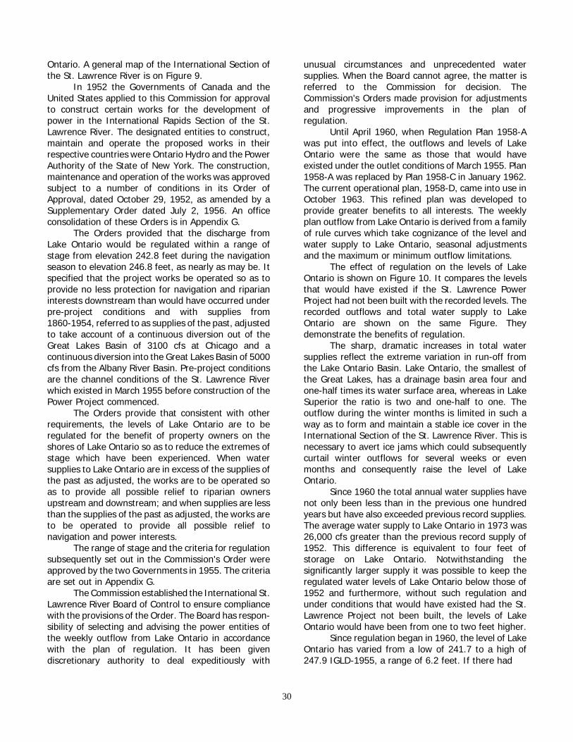
Ontario. A general map of the International Section ofthe St. Lawrence River is on Figure 9.
In 1952 the Governments of Canada and theUnited States applied to this Commission for approvalto construct certain works for the development ofpower in the International Rapids Section of the St.Lawrence River. The designated entities to construct,maintain and operate the proposed works in theirrespective countries were Ontario Hydro and the PowerAuthority of the State of New York. The construction,maintenance and operation of the works was approvedsubject to a number of conditions in its Order ofApproval, dated October 29, 1952, as amended by aSupplementary Order dated July 2, 1956. An officeconsolidation of these Orders is in Appendix G.
The Orders provided that the discharge fromLake Ontario would be regulated within a range ofstage from elevation 242.8 feet during the navigationseason to elevation 246.8 feet, as nearly as may be. Itspecified that the project works be operated so as toprovide no less protection for navigation and riparianinterests downstream than would have occurred underpre-project conditions and with supplies from1860-1954, referred to as supplies of the past, adjustedto take account of a continuous diversion out of theGreat Lakes Basin of 3100 cfs at Chicago and acontinuous diversion into the Great Lakes Basin of 5000cfs from the Albany River Basin. Pre-project conditionsare the channel conditions of the St. Lawrence Riverwhich existed in March 1955 before construction of thePower Project commenced.
The Orders provide that consistent with otherrequirements, the levels of Lake Ontario are to beregulated for the benefit of property owners on theshores of Lake Ontario so as to reduce the extremes ofstage which have been experienced. When watersupplies to Lake Ontario are in excess of the supplies ofthe past as adjusted, the works are to be operated soas to provide all possible relief to riparian ownersupstream and downstream; and when supplies are lessthan the supplies of the past as adjusted, the works areto be operated to provide all possible relief tonavigation and power interests.
The range of stage and the criteria for regulationsubsequently set out in the Commission's Order wereapproved by the two Governments in 1955. The criteriaare set out in Appendix G.
The Commission established the International St.Lawrence River Board of Control to ensure compliancewith the provisions of the Order. The Board has respon-sibility of selecting and advising the power entities ofthe weekly outflow from Lake Ontario in accordancewith the plan of regulation. It has been givendiscretionary authority to deal expeditiously with
unusual circumstances and unprecedented watersupplies. When the Board cannot agree, the matter isreferred to the Commission for decision. TheCommission's Orders made provision for adjustmentsand progressive improvements in the plan ofregulation.
Until April 1960, when Regulation Plan 1958-Awas put into effect, the outflows and levels of LakeOntario were the same as those that would haveexisted under the outlet conditions of March 1955. Plan1958-A was replaced by Plan 1958-C in January 1962.The current operational plan, 1958-D, came into use inOctober 1963. This refined plan was developed toprovide greater benefits to all interests. The weeklyplan outflow from Lake Ontario is derived from a familyof rule curves which take cognizance of the level andwater supply to Lake Ontario, seasonal adjustmentsand the maximum or minimum outflow limitations.
The effect of regulation on the levels of LakeOntario is shown on Figure 10. It compares the levelsthat would have existed if the St. Lawrence PowerProject had not been built with the recorded levels. Therecorded outflows and total water supply to LakeOntario are shown on the same Figure. Theydemonstrate the benefits of regulation.
The sharp, dramatic increases in total watersupplies reflect the extreme variation in run-off fromthe Lake Ontario Basin. Lake Ontario, the smallest ofthe Great Lakes, has a drainage basin area four andone-half times its water surface area, whereas in LakeSuperior the ratio is two and one-half to one. Theoutflow during the winter months is limited in such away as to form and maintain a stable ice cover in theInternational Section of the St. Lawrence River. This isnecessary to avert ice jams which could subsequentlycurtail winter outflows for several weeks or evenmonths and consequently raise the level of LakeOntario.
Since 1960 the total annual water supplies havenot only been less than in the previous one hundredyears but have also exceeded previous record supplies.The average water supply to Lake Ontario in 1973 was26,000 cfs greater than the previous record supply of1952. This difference is equivalent to four feet ofstorage on Lake Ontario. Notwithstanding thesignificantly larger supply it was possible to keep theregulated water levels of Lake Ontario below those of1952 and furthermore, without such regulation andunder conditions that would have existed had the St.Lawrence Project not been built, the levels of LakeOntario would have been from one to two feet higher.
Since regulation began in 1960, the level of LakeOntario has varied from a low of 241.7 to a high of247.9 IGLD-1955, a range of 6.2 feet. If there had
30

Figure 10. REGULATION OF LAKE ONTARIO 1960-1974
31

been no regulation and the St. Lawrence Power Projecthad not been built, the level would have varied from alow of 241.4 in December 1964 to a high of 249.1 inJune 1973, a range of 7.7 feet.
Furthermore, the outflow from Lake Ontario forthe months of June and July 1973 was 350,000 cfs,whereas under pre-project conditions the dischargewould have been 15,000 to 30,0000 cfs less, thusraising the water level in Lake Ontario. The extra flowwas possible through the cooperation and tacitconcurrence of the Province of Québec. This regulationreduced the peak summer level by 1.2 feet and duringthe following winter by as much as 2.4 feet below thatwhich would have occurred had there been noregulation.
Although regulation has, in absolute terms,benefited the property owners on Lake Ontario, as well
as navigation and power interests in comparison withconditions which would have prevailed underpre-project conditions, property owners at severalpublic hearings expressed their view that their interestscould have received more protection. The Commissionis satisfied that the regulation carried out under itsdirection by its International St. Lawrence River Boardof Control has provided a good and judicial balancebetween the various interests and that none of theinterests could have received more protection withoutserious detriment to the others or to riparian interestsdownstream in the Canadian Section of the River.
It must be recognized that during periods ofunprecedented deficient or excessive precipitation,regulation can only alleviate, not entirely eliminate, theadverse conditions caused by the unpredictable anduncontrollable forces of nature.
32

Chapter VII
CHRONOLOGY OF EVENTS
The Commission's role in the Great Lakes WaterLevels inquiry began with the receipt of the October 7,1964 Reference from the United States and CanadianGovernments. The studies required by the Referenceand discussed in Chapter II involve consideration ofcomplex technical problems and conflicting uses of thewater of the Great Lakes.
In late October and early November 1964,members of the Commission with United States andCanadian agency representatives toured affected areasof the United States and Canadian shoreline to viewfirst-hand some of the problems associated with thethen prevailing low water levels.
The Commission, on December 2, 1964,established the International Great Lakes Levels Boardand appointed to it six experts, three from Canadianagencies and three from United States agencies. TheCommission directed the Board to undertake thenecessary investigations and studies and to advise theCommission on all matters which it must consider inreporting to the Governments on the Reference.
The Commission met with Provincial officials inToronto on January 20, 1965 to receive their viewsconcerning the Great Lakes levels study. Similarly, at ameeting in Detroit on February 24, 1965, comment wasreceived from representatives of the eight Great LakesStates and the Great Lakes Commission.
In order to provide this Commission with afeeling for the concerns and interests of the people inthe Basin at the outset of the study, public hearingswere conducted at Toronto on May 10, 1965, at SaultSte. Marie, Michigan on May 11, at Windsor on May 25,and at Chicago on May 26, 1965.
The Commission in its Directive to the Boardrequested an outline and a cost estimate of theproposed investigation as soon as possible. InSeptember 1965 the Board submitted an outline for afive-year study costing over $2 million. The studyoutline did not include an estimate of time and fundingfor design and related field investigations for regulatoryworks which might subsequently be proposed. TheBoard advised the Commission that it would report onthis matter at a later date. The Commission approvedthe Board's initial study outline and cost estimate onOctober 7, 1965.
The Board's study program was divided into twobroad phases. The first phase, which extended to thespring of 1967, consisted of collection and compilation
of data, development of procedures for evaluating theeffects of lake level fluctuations on the users of GreatLakes waters and the development of preliminaryapproaches to regulation. The Board briefed theCommission on these activities at a two-day meeting inJanuary 1967. In the second phase of the program theresults of preliminary regulation studies, coupled withdata collected on the effect of lake level fluctuation onthe shore property, power and navigation interests,were used to establish criteria for the development ofoperable regulation plans and to evaluate the effect ofthese plans on the various interests. The views andparticipation of Great Lakes States and Provinces wereactively sought in the studies.
The Board submitted to the Commission twentysemiannual progress reports throughout the study andspecial reports on such other occasions as problemspresented themselves.
In August 1968 because of the importance andmagnitude of the inquiry the Commission furnished anInterim Report to the two Governments on the studyprogress to date. The Commission reported that thefirst phase of the investigation was virtually completed.Basic data on properties and installations along some11,000 miles of shoreline, on all aspects of commercialnavigation and recreational boating, and on existinghydroelectric plants had been collected, compiled andevaluated. Recorded data on levels and flows had beencoordinated and adjusted to insure internationalagreement and compatibility. Computer programs hadbeen used extensively to simulate hydrologic data andassist in development of regulation plans. The reportnoted that detailed investigation of regulatory workswould be required if preliminary cost estimates werefound to be compatible with preliminary estimates ofeconomic benefits.
As mentioned earlier, the initial study outline didnot contain schedule time or funds for design andrelated field investigations for regulatory works whichmight subsequently be proposed. The Commission wasadvised by its Board in the fall of 1968 thatinvestigations indicated the probable need for detailedstudies of regulatory works. Two years additional timewould be required and total study costs would be about$4 million. The Board noted that the validity of the newschedule and cost estimate was dependent on receiptof appropriations and availability of manpower in atimely manner. A year later the Board advised the
33

Commission that the detailed studies of regulatoryworks were required. Because the levels of the GreatLakes during this period were about average andagencies had other national priorities, the Board furtheradvised the Commission that it was unable to obtainthe resources necessary to expedite these additionalinvestigations and the study period would have to beextended to October 1973.
At a meeting in Cleveland in December 1969, theCommission was briefed by its International GreatLakes Levels Board on the study procedures and resultsto date and in particular, on the major assumptionsutilized in the study. The Commission providedguidance to the Board on these matters and directedthe Board to proceed with its revised schedule ofstudies.
At a meeting in Detroit in March 1971, theCommission after being apprised of the results of thestudies to date and the criteria and objectives beingdeveloped by the Board, advised the Board to proceedwith the scheduled detailed studies.
The studies continued essentially as scheduledthroughout the remainder of the investigation. OnJanuary 15, 1973 because of very high water levels onthe Great Lakes, the Commission advised itsInternational Great Lakes Levels Board that, as a resultof discussions with its International Lake SuperiorBoard of Control, it was considering, as a matter ofurgency, the possibility of operating the control worksat Sault Ste. Marie in such a way as to provide relief forthe Lower Great Lakes and at the same time maintainsatisfactory conditions on Lake Superior. The Board wasrequested to report, prior to March 1, 1973, its interimfindings and conclusions with respect to possiblemodified operations at Sault Ste. Marie. The Board onMarch 15, 1973 submitted an Interim Report on a planto regulate Lakes Superior and Ontario.
Public hearings were held during May 1973 atRochester, Toronto, Detroit, and Sault Ste. Marie andin Duluth in June to obtain public reaction to theInterim Report. After considering the information fur-nished in the Board's Interim Report and the viewsexpressed at the hearings, the Commission transmittedto the Governments in June 1973 its Special InterimReport on regulation of Lake Superior outflows to pro-vide relief from high water levels on the Lower GreatLakes.
In its Special Interim Report the Commissionrecommended that the Government of the UnitedStates and the Government of Canada approve, as theobjective for regulating Lake Superior outflows in thefuture, the provision of benefits to interests throughoutthe Great Lakes System without undue detriment toLake Superior interests. To achieve this objective, allcontrol works in the St. Marys River would be operatedso as to keep the levels of Lake Superior and Lakes
Michigan-Huron at the same relative position withintheir recorded ranges of stage and with respect to theirmean monthly levels. Under such operation, the levelof Lake Superior would be maintained, as nearly asmay be, within its recorded range but below elevation602.0 feet IGLD1955, the upper limit establishedpursuant to the Commission's 1914 Orders of Approval.
It was also recommended that the twoGovernments jointly grant the Commission specificauthority to: Amend its Orders of Approval, dated May26 and 27, 1914; prescribe a plan of regulation for LakeSuperior; direct the operation of all control works in theSt. Marys River; and delegate its authority overregulation and operation to an International Boardappointed by the Commission.
The Commission also recommended that the twoGovernments make provision for the disposition ofclaims for physical injury or damage to persons orproperty occurring in their respective territories andresulting from the maintenance and operation of theexisting control works in the St. Marys River pursuantto the above objective and for the satisfaction of suchclaims as are valid.
In order to permit safe operation of these controlworks under winter conditions, the Commissionrecommended that the physical improvements to thecontrol structure suggested by the Board beundertaken without delay. The Commission stated thatunless otherwise instructed by Governments it wouldcontinue the course of action which it undertook onJanuary 30, 1973, to direct regulation consistent withthe above objective, until either the emergencysituation eased downstream or Lake Superior conditionsrequired reversion to the 1955 Modified Rule of 1949.
The Commission on June 29, 1973 directed theInternational Lake Superior Board of Control to regulatethat lake in accordance with the stated objective usingas a guide the regulation rules of Plan SO-901 asdescribed in the International Great Lakes LevelsBoard's interim report. The Commission has kept thewater level situation in Lake Superior and the LowerLakes under continuing review. In January 1974 theCommission pointed out to the two Governments itsconcern that it had not received further instructions inresponse to the Special Interim Report. The twoGovernments have not, as of this date, transmitted therequested instructions to the Commission.
The Commission received the Board's main reportin March 1974, an illustrated summary report duringthe summer, and all of the appendices by October1974. The reports and appendices were given extensivepublic distribution by the Commission as soon as theywere received. Public hearings were held in thirteencities around the Great Lakes to receive comments onthe Board's report and further information frominterested individuals, associations and governmental
34

agencies.The Commission in the course of its deliberations
recognized that it could not fully answer all the ques-tions raised in the Reference. In a letter dated May 23,1975 it informed the two Governments of the necessityfor specific further studies and requested support forthem. It was noted that the environmental aspects andthe net benefits of Lake Erie regulation were notadequately covered in the Board's report nor in theUnited States Corps of Engineers' proposal forregulation of Lake Erie. Similarly, the Commission wasof the opinion that further information is required toascertain what measures would be practicable toaccommodate increased flows in the St. Lawrence Riverwith a view to improving the regulation of Lake Erieand Lake Ontario. Copies of the correspondence are inAppendix J.
It may appear surprising that the total time takenfor the completion of the inquiry was over a decade.This, in the view of the Commission, is manifestly anunfortunate time span in the conduct of even somassive an investigation as the present one. Therewere many difficulties arising from beginning an inquiryin one decade and completing it in another, eventhough there were incidental advantages in the presentcase. This investigation began at a time of low waterwhile the Board's report, ironically, was completed
during a period of high water. Thus, both low and highwater perspectives on lake levels and their regulationbecame available to the Board and to the Commission.
Nevertheless, the Commission believes that theinterests of both countries are better served by a morerapid completion of investigations, however extensivethe study may be. In this case, the chronologydemonstrates that the delays were due to a mixture ofproblems in funding, problems of allocation ofpersonnel and changes in personnel which interruptedsustained activity by the Board, its Committees and theCommission itself. There are important lessons to belearned from this experience: First, in any referencefunding must be assured and provided so as to preventserious delays in the investigation; second, continuityof board and committee personnel from the agenciesinvolved is needed to ensure against frequent timetabledifficulties.
The full story, therefore, of the Great Lakeslevels inquiry should be seen in light of these causes forthe delay, the possible gains from the doubleperception of high and low water, and the lessonstaught by this experience for the benefit of bothGovernments and the Commission, with respect tofuture references, their funding and their allocation ofmanpower.
35


Chapter VIII
THE TECHNICAL INVESTIGATION
The International Great Lakes Levels Board, onreceipt of its Directive from the Commission in December1964, proceeded with the preliminary planning necessaryto undertake the investigations required by theReference. The results of the Board's studies are givenin detail in its report to the Commission dated December1973, and the seven appendices attached thereto.
Organization
In organizing for the studies under the Reference,the Commission fully utilized the offer of the two FederalGovernments contained in the Reference to "uponrequest, make available to the Commission the servicesof engineers and other specially-qualified personnel oftheir governmental agencies and such information andtechnical data as may have been acquired or may beacquired by them in the course of the investigation." Thishas provided the Commission and its Board with a broadrange of professional talent, data and experience in thedisciplines necessary to complete the Commission'sextensive assignment. Nearly 150 experts from 22agencies, supported by technical staffs, participatedactively in the studies. These included engineers,economists, biologists, ecologists and land-use planners.
The Board appointed a working committee onJanuary 6, 1965 to assemble the necessary data,organize the field activities and conduct the studiesrequired by the Reference. In order to bring specializedtalent to bear on specific study areas, the workingcommittee initially appointed four subcommittees: ShoreProperty; Regulation; Navigation; and Power. The fourcategories include all of the interests identified in theReference for which improved water level conditionsshould be investigated: Domestic water supply andsanitation, navigation, water for power and industry,flood control, agriculture, fish, wildlife and recreation.The Shore Property Subcommittee considered the effectsof variations in water levels on flood control, domesticwater supply and sanitation, water for industry, marinestructures and fish, wildlife and recreation. Because ofthe special nature of the studies of fish, wildlife andrecreation, the subcommittee prepared a separateappendix covering its activities in these areas. Later inthe Board's studies, as the need became evident, theRegulatory Works Subcommittee and the ReportsSubcommittee were formed. A number of short-lived,ad-hoc groups, such as the committees on economicsand fisheries, were formed to investigate several areasrequiring the short-term application of highly-specializedskills.
Considerations and Constraints
The needs of the diverse and often conflictinginterests who use the Great Lakes were taken intoaccount. The Board found that the users fall into fourgeneral categories of interest—shore property; fish, wildlifeand recreation; navigation; and power. The detailedinvestigations into methodology for evaluating the effectsof water level fluctuations on the four interests are givenin Appendix C—Shore Property, Appendix D—Fish, Wildlifeand Recreation, Appendix G Navigation, and AppendixF—Power, of the Board's report. The factors to be takeninto account with respect to each are discussed below.
Shore Property Interests—This category of interestis concerned with the effects of water level variations onerosion and inundation of the shoreline, primarily a floodcontrol problem; on the operation of water intakes andsewer outfalls, which relates to the question of domesticwater supplies and sanitation and water for industry; andon marine structures such as marinas and commercialdocks. Agricultural interests have been found to beaffected primarily by loss of agricultural land or its usethrough erosion or inundation. Because of the seasonalvariations and wind-induced waves which aresuperimposed on the long-term fluctuations, shorelineconcerns are most pronounced when excessiveprecipitation has significantly raised lake levels or whenpersistent drought has lowered levels. On the other handsome kinds of shore property damage can occur at bothhigh and low lake levels. Damage due to high water mayresult from flooding, erosion of the shore or from the effectof wave action on shoreline structures. Erosion is acontinuous process, the effects of which are mostpronounced during periods of high water. During low waterperiods, major economic damage results from the reduceddepths available to recreational beaches, small boatharbours, and marinas. Damage also occurs in the lowerreaches of tributary streams where the available depthsare controlled by the level of the lake.
Many factors in combination with the lake level havea direct effect on shore property damage. These factorsinclude wind, barometric pressure differentials, the time ofyear, and the geological formation of the area. There arealmost unlimited variations in lake surface activities, shorecharacteristics and natural events which produce shoreproperty damage. As a general rule the shore propertyinterests desire a reduction in the range and the frequencyof extreme water levels although at any given time theirinterests may conflict with one another, depending on theirgeographic location.
Fish, Wildlife and Recreation - There are varying
37

effects from water level fluctuations on fish and wildlifeprincipally because of their effects on marsh areas andshallow spawning areas. It should be noted, however,that the entire lake and river system plays a part in thedevelopment and maintenance of the existing ecosystemand that changes to any part of the system by regulationof water levels could affect the whole system, not justthe marshlands and shore areas. In addition some partof the long-term fluctuation and the seasonal variationsis essential to the maintenance of the ecosystem. Withrespect to recreation, the effect of water level fluctuationis primarily related to the quantity and quality of beachesand the availability of fish and game.
Navigation Interests— The commercial navigationsystem within the Great Lakes is maintained to accom-modate the present Great Lakes fleet and overseastraffic entering and leaving through the St. LawrenceSeaway. The advertised navigation depths in the systemare related to an agreed level on each lake. This agreedlevel, which is called the low water datum plane, is theone below which the project depths for dredging ofchannels and harbours are measured. It is a low lakelevel, which is exceeded most of the time. Experience onthe lakes over the past fifty years had demonstrated thatship owners take full advantage of all available depths inthe channels and harbours. There are some vessels onthe Great Lakes of such characteristics that they can loadto full draft only during periods of extreme high levels.Hence, navigation interests advocate maintainingrelatively high minimum levels throughout the systemduring the navigation season to allow greater draft forvessels, as well as maintaining high minimum flows inthe Connecting Channels during the same period tomaintain the depths in those Channels. There is equalconcern with the maximum levels which governelevations at the docks, and with the frequency andduration of high flows which affect river currents andvelocities.
Power Interests - In the long run, power interestsdesire flows to be as uniform as possible and,particularly, high minimum flows to increase their firmpower capacity. On a short-term basis they desireflexibility of operation which would permit short-periodvariations in the daily, weekly or monthly mean flow andwhich would, in effect, increase the dependable flowavailable for power during peak load periods. In thedesign of channel enlargements for power it isadvantageous to power interests to have the lake levelsas high as possible since these high levels help reducethe cost of excavating the channels.
It is also of importance to the power interests thatthe flows during the winter months be such to ensurethe formation and retention of a stable ice cover on theoutflow rivers. This would minimize ice jams in the rivers,clogging of turbine intakes, and make it possible todischarge flows to meet high load requirements during
the winter season. Since seasonal load requirements aregenerally greater during the winter months, the minimumflows during the winter should be greater than those forthe summer.
A stable ice cover is also of prime concern to shoreproperty owners. A serious ice jam in the InternationalRapids Section of the St. Lawrence River could causeinvoluntary storage of an extra foot of water on LakeOntario. The seriousness of such an ice jam occurring inyears of high water levels such as those of the early 1970'scannot be overestimated. The stabilization of the Lake Erieice cover at Buffalo by the Lake Erie-Niagara River iceboom has significantly reduced the shoreline ice damagein the Niagara River.
Because of the physical constraints inherent in theGreat Lakes System, the wide variations in water supplyfrom month to month and the diversity of interestsinvolved, the Board's studies indicated that it is notpossible to make the dramatic changes by lake regulationwhich some people might like to see made. However, itfound that by considering the Great Lakes System as awhole, recognizing that what is done in the upper lakeshas an effect on the lower lakes, improvements can bemade in the regime of the water levels and outflows tobenefit the users of the system.
Methodology for Evaluating Lake Regulation Plans
The Board developed and tested regulation plans tomeet certain objectives and criteria, using water supplieswhich have occurred in the past, to determine the degreeto which regulation can be accomplished and the cost ofimplementation. In the development of these plans, theBoard made a number of basic assumptions concerning thesystem. These are discussed below.
Before undertaking to change a regime of waterlevels on a lake, one needs to know how such a changewould affect the people using the lake. The effects can betranslated into economic or dollar effects, environmentaleffects and hydrologic effects. All regulation plans whichwere examined in detail were evaluated with the sameeconomic and hydrologic data to ensure a validcomparison.
Economic Effects of Regulation — Some effects arerelatively easy to translate into dollar values of theircommercial nature. Power and navigation interests areexamples where well-established methods are available totranslate water level and flow changes into dollar amountsfor the purpose of project evaluation and justification. Withregard to the effect of a changed water level regime onrecreational beaches and on shoreline property, a lack ofbasic data precludes as precise a conversion of the effectsinto dollar values as can be obtained for the power andnavigation interests. As the available field data grows, andserious efforts are underway in both countries to acquiresuch information, the precision of evaluating shoreline
38

effects will increase. Furthermore, it is even moredifficult to place an economic value on environmentaleffects of changed level regimes.
The methodology for evaluating the effects ofregulation on navigation is based on a concept that shipsthat can take advantage of deeper water will load to themaximum safe draft available. Any increase or decreasein lake levels will change the cargo-carrying capacity ofsome vessels. Where regulation can provide greaterdepths in navigation channels and harbours, fewer vesseltrips would be required. Conversely, where regulationprovides lesser depths, more vessel trips would berequired. The number of trips required, multiplied by theaverage number of hours for each trip for each of thevarious routes, multiplied by total vessel cost per hourwas taken as the measure of cost for transporting theselected bulk commodities. The difference in cost oftransporting the various bulk commodities under a newregulation plan as compared to the cost without the newplan is taken as the benefit or loss to navigation.
In making its assessment of the navigationsystem, the Board assumed that there would be noincrease in the controlling depth of the Great Lakesnavigation system beyond the present 27 feet. Thus thecosts of any necessary channel dredging in theConnecting Channels and St. Lawrence River forregulation would not be chargeable to navigation.
Hydro-electric installations on the outlet rivers thatcould be affected by changes in the water level and flowregime of the system are those existing on the St. MarysRiver, Niagara River, the Welland Canal and St. LawrenceRiver. The potential benefits or losses to the ultimatepower user would depend on how the overall costs ofproducing the power needed to service the expectedsystem loads would be affected by further regulation ofthe Great Lakes. The capacity and energy available frompower installations depends primarily upon the availableflows and to a lesser extent on the net head. Theincreased or decreased system costs which would resultfrom changes in the capacity and energy outputoccasioned by the changed level and flow regime underregulation provide a measure of the dollar effect on thepower system.
Changes in the level regime on the Lakes and theirConnecting Rivers affect the rate of erosion of the shoreline and the time during which portions may beinundated. This results in changes in the rate of land lossand accretion, of structural damage or loss, and of flooddamages. The Board developed water level-damagerelationships, reach by reach, for the entire shoreline ofthe Great Lakes, some 11,200 miles. These relationshipstake into account the physical and hydraulic factorspresent in each reach which effect damage. They includethe nature of shore materials, exposure to onshorewinds, configuration of the shoreline and the ability ofthe shoreline to absorb energy.
Since considerable data were available from surveysmade along the United States shoreline during the highwater levels in 1951-52, these data were utilized, as abasis for development of the water level-damagerelationships for the United States shoreline.
A complete survey of the Canadian shoreline of theGreat Lakes and Connecting Rivers was made during 1966and 1967. This survey included a detailed inventory ofshore characteristics, land use, marine structures,long-term erosion rates and flood levels. Using theinformation derived from this survey, a mathematicalmodel was developed to provide an estimate of damagethat would occur for all months, for all reaches, and forany water level. The results were substantiated bycomparison with historical data.
Projections were made of future shoreline use anddevelopment and incorporated into the assessment. Futuredevelopment of Great Lakes shoreline would be affected tosome degree by land-use planning and zoning. Assumingthat effective land-use controls can be achieved within areasonable period, future damages can be limitedessentially to existing structures and to loss of landthrough erosion.
The Board found that maintenance dredging ofmarinas needed to be considered. It determined the differ-ence in dredging costs with and without the proposed planof regulation in operation, for the facilities estimated to bein place during the project life. The difference between thetwo represents the effect of regulation on marina dredgingcosts.
Environmental Effects - The environment may bedefined as the sum total of the physical and social factorswhich affect the existence of an organism. Important tothe human environment are the factors of aesthetics,beauty and human sensitivity which provide an essentialquality of life.
Determination of the environmental effects offurther regulation involves the identification of theprobable changes that would take place followed by anevaluation of whether such changes were beneficial orharmful. The Board classified the effects of such changesin four categories: ecological; hygienic; aesthetic, and thesocial well-being of people.
Many factors are involved in any assessment of anecosystem. In the area of fishery the Board considered theeffects of level and flow changes, changes in velocity, inturbidity and other physical changes brought about byproposed regulation and the construction and operation ofworks necessary to achieve regulation. The Board made ajudgmental assessment of the effects of these changes onfishery. With respect to wildlife, the Board considered thereduction or increase in available wetland around the Lakesdue to further regulation. These assessments were theindicators which the Board used to identify probable effecton the ecosystem.
The Board considered the effect of level and flow
39
changes on the use of the Great Lakes water fordomestic and sanitary purposes. In particular, the impactof changing water levels on existing water intakes andsewer outfalls, including industrial and storm wateroutfalls, was fully addressed in the study.
Assessment of aesthetic effect was concentratedon those changes that are clearly attributable toregulation and would produce a public reaction. Theseinclude changes in appearance of the aquatic or landenvironment, the taste of water, fish and wildlife and inbottom characteristics of streams.
Social well-being is defined in terms of generalwell-being of individuals and the viability of communitiesin which they reside. The assessment and evaluation ofimpacts on social well-being are hindered by the inabilityto assess quantitatively the values of many, if not most,human experiences and needs. Physical changes such asdisplacement of individuals or groups of individuals, areobvious. But many of the emotional, intangible impactsthat result from change, are not so obvious. A primesociological concern is to preserve existing intra andinter-community relationships that are essential tocommunity viability and integrity. Indicators used tomeasure change in social well-being include theconveniences to communities and individuals,recreational and employment opportunities, disruption oflife styles, relocation of individuals, land-use changes,and general security of life and health. Assessment ofeffects on social well-being required full use ofinformation generated in the assessment of ecological,hygienic, aesthetic, and economic effects.
Hydrologic Effects of Regulation — Analysis oflake levels and outflows involves consideration of theirmaximum, mean and minimum monthly values and theirrange, duration and seasonal distribution. Criteria weredeveloped to measure the degree to which the purposesof regulation have been achieved.
Development of Regulation Plans
A regulation plan for a lake is a predetermined setof rules for changing the existing pattern of outflowsfrom the lake in order to create a more favourableregimen of water levels and discharges. Regulatoryworks are required to provide the necessary control overoutflows. They might consist of channel deepening in theoutlet channel to increase flows, coupled with gatedstructures to reduce outflows below the capacity of thechannels.
Past monthly levels and outflows of a lake reflectthe manner in which past water supplies were routed by nature through the then existing outflow channels. Aregulation plan is a procedure for routing water suppliesthrough the control works to achieve certain desirableobjectives, such as a reduced range of water levels onthe lake.
We do not have the ability to predict future watersupplies. Such knowledge would permit an increase inoutflow if we knew high supplies were coming. In theabsence of such knowledge we must use past supplies asa gauge to estimate what will happen in the future and totest regulation plans. The Board buttressed this approachby creating simulated supplies of different magnitude andsequence to further test the regulation plans and to beassured that the plans would perform suitably undervarious supply regimens.
The Board developed plans for the coordinatedregulation of Lakes Superior, Michigan, Huron, Erie andOntario (SMHEO Plans); Lakes Superior, Michigan, Huronand Ontario (SMHO Plans); Lakes Superior, Erie andOntario (SEO Plans) and Lakes Superior and Ontario (SOPlans). Several hundred plans were tested.
A three-stage procedure was employed in thedevelopment of the regulation plans. In the first stage, amathematical procedure was employed to determine theabsolute upper limit of total benefits that would possiblyaccrue to the three major interest groups under anysystem of regulation. These figures were then comparedwith order of magnitude cost estimates to give apreliminary assessment of economic feasibility. In thesecond stage a number of plans were tested; each wasconcerned with meeting a specific operating objective.These plans were developed to meet broad operatingobjectives such as maximum economic benefit for thesystem, no economic loss to any major interest, no changein mean lake level and satisfaction of existing regulationcriteria. Results from the first stage were used to helpidentify means of meeting the various objectives. Forexample, it was apparent from these studies thatmaximum benefit from Lake Superior regulation could berealized by balancing storage between Lake Superior andLakes Michigan-Huron.
The results of plans developed in the second stage,together with their corresponding objectives and criteriawere reviewed, and final objectives and criteria adopted.The third stage consisted of the development of a plan tosatisfy the adopted objectives and criteria. Detailed benefitevaluations, including economic, environmental andhydrologic analysis were then carried out. Conceptualdesigns and cost estimates of the works required toprovide regulation capability were then made.
Tabular summaries showing the benefits and costsand hydrologic effects of typical plans evaluated are Tables4 and 5 at the end of this Chapter. A detailed breakdownof benefits and costs for each plan are given in the Board'sreport. A breakdown of the average annual benefits foronly Plan SO-901 are shown in Table 3 of this Chapter.
Evaluation of Regulation Plans
The Board selected for detailed benefit-cost evalua-tion regulation plans for the four lake combinations---
40

SMHEO, SMHO, SEO and SO. The regulation plans areidentified by using the first letter of the lake beingregulated. The appended number identifies the planselected to best meet particular criteria and objectivesfor the combination of lakes being regulated.
The evaluation is based on a comparison of thelevel and outflow regimes which would have existed inthe period 1900 to 1967 inclusive, under both existingconditions and the proposed regulated conditions. Theperiod 1900-1967 was used because earlier data werenot sufficiently reliable for this investigation. Existingconditions reflect present diversions, channel capacitiesand operation of the present regulation plans for LakeSuperior and Lake Ontario. This is called the basis ofcomparison. It is the standard to which the proposedregulation plans were compared to determine theimprovement achieved.
The Board in their economic evaluation used aproject life of fifty years, an interest rate of sevenpercent, a common United States-Canada dollar, and1971 price levels.
The basis of comparison adopted by the Board forevaluating plans for the SMHEO, SMHO and SEO lakecombinations which would require construction ofextensive regulatory works is based on the 1933 outletconditions from Lake Huron. The 1933 outlet conditionsare those that existed prior to the dredging of the25-foot navigation channels in the St. Clair and DetroitRivers. Those navigation channels were further deepenedto 27 feet in 1962. The Board adopted the 1962 outletconditions from Lake Huron for the SO and SEO planswhich could be implemented with a minimum of newregulatory works.
The use of the 1933 Lake Huron outlet conditionfor plans involving extensive regulatory works recognizedthe exchange of Notes between the two Governmentswhich indicated the intent of providing compensatingworks to return water levels to conditions which existedin 1933. In the event that the water level-flowrelationship is not returned to 1933 conditions, additionaldredging would be required beyond that determined bythe Board to meet the objective for the SMHEO andSMHO plans to provide a more beneficial range of stagewith a minimal loss to any interest.
As the Board's studies progressed, the resultsindicated that the return of levels on LakesMichigan-Huron to the higher water levels which wouldexist under 1933 conditions would result in an averageannual damage of $12 million to shoreline property. TheBoard also estimated that $1.3 million in average annualbenefits would accrue to navigation from higher levels.
SMHEO and SMHO Plans — Studies were made ofplans for the regulation of all five lakes (SMHEO Plans)and of four lakes (SMHO Plans). Preliminary estimates forthese regulation plans indicated that the costs ofimplementing them would be several times the benefits
which could be expected. Since the plans were not viablefrom an economic standpoint, the Board documented themonly to the degree necessary to thoroughly substantiatethis conclusion.
Two plans, SMHEO-38 and SMHO-11, were selectedfor detailed evaluation as to their effect on shore property,navigation and power. The hydrologic effects of theseplans are given on Table 5 at the end of this Chapter.These plans were not economically feasible and thereforethe Board did not undertake detailed environmental impactstudies. It determined, however, that adverse effects couldbe expected on the fishery in the St. Clair River and LakeSt. Clair because of construction and operation of thenecessary flow control structures. It also found that, ingeneral, there would be some adverse effects to wildlifedue primarily to reduction of available wetlands and effectsof construction and that possible increases in pollution inthe stagnant water behind the dams in the St. Clair andDetroit Rivers might be expected. Both regulation plansrequire a capital investment of about $0.5 million toimprove the control structure above the St. Marys Rapidsfor safe year-round operation.
Additional costs may be incurred to assure continuedstability of the control works. Recently the InternationalLake Superior Board of Control reported the possibility ofundermining of some pier foundations. A detailedinvestigation is necessary to verify this. It is imperativethat the foundation investigations be undertaken as soonas practicable regardless of alternative plans to eithermodernize or redevelop.
Regulation of Lakes Michigan and Huron requires notonly an increase in the capacity of the channels of the St.Clair and Detroit Rivers, but also the ability to restrict theoutflows below the capacity of the channel. The Boardrecognized that works necessary to achieve suchregulation must be designed to meet certain ratherrestrictive requirements. They should, in the interest of theshoreline owners, maintain the water surface profile in theSt. Clair-Detroit River system; they should not beintolerably restrictive to commercial navigation; theyshould not inhibit fish movement unduly; they shouldresult in minimum environmental impact; they must becompatible with the rivers' ice regime and be operableyear-round.
After investigating a number of possibilities, theBoard concluded that additional dredging and a series ofcontrol structures would be required in the St. Clair andDetroit Rivers. Each set of regulatory structures include acombination of gated sections and training walls to controlthe flow and small boat passages. No locks would berequired in this portion of the Great Lakes System. Thelocation of the structures required for the four-lake plan,SMHO-11, are shown on Figure 11. The five-lake planwould require an additional structure at Fawn Island in theSt. Clair River, and also dredging and a regulatorystructure in the Niagara River. A sketch of a typical
41

42

43

regulatory structure for the St. Clair-Detroit River systemis shown on Figure 12. In addition to dredging, the worksnecessary to regulate this system would include 28,000feet of training walls, 12 gated sections containing a totalof 172 fifty-foot double-hinged gates, and nine small boatpassages. Details of the design of these works are givenin Appendix G of the Board's report.
At present, Lake Erie outflows are controlled by therock ledges which form a natural weir in the NiagaraRiver in the area between the Peace Bridge and the headof Squaw Island. Dredging of this natural weir would berequired to increase the outflow from Lake Erie requiredfor the five-lake plan. Initially, the Board considered twopossible locations for control structures, with associateddredging, on the upper Niagara River. See Figure 13.Submersible tainter gates at the lower site were selectedfor preliminary design. Tainter gates were chosenbecause of their ability to pass ice runs and to respondquickly to seiche conditions which are common at theeast end of Lake Erie.
The overall capital costs for the SMHO and SMHEOplans would be $240 million and $370 million,respectively. Annual costs including interest, amortization,operation and maintenance costs would be $18 millionand $28 million, respectively.
With annual average costs of $18 million andannual average benefits of $2 million, annual costs forthe four-lake SMHO plan would be over six times theexpected annual benefits. Similarly, with annual averagecosts of $30 million and average annual benefits of $10million, the five-lake SMHEO plan annual costs would benearly three times the expected annual benefits.
SEO Plans — Three approaches to the coordinatedregulation of Lakes Superior, Erie and Ontario wereinvestigated by the Board. The first involved regulation ofLake Erie with channel enlargements and a controlstructure in the upper Niagara River. The second involvedchannel enlargement only in the upper Niagara Riverwhile the third approach involved increasing the outflowsfrom Lake Erie during periods of above-average supply bydiverting additional outflow through the Welland Canal,the New York State Barge Canal or the Black Rock Canal.The Black Rock Canal diversion was chosen as the mostpromising. In this scheme, a diversion channel throughSquaw Island with a gate mechanism to control flowwould permit increased flows to bypass the controlsection in the Upper Niagara River. The plans prepared bythe Board to represent the three approaches in numericalorder are: Plan SEO-33, a control structure combined withdredging; Plan SEO-901, with only channel enlargement;and Plan SEO-42P, utilizing a controlled diversion throughSquaw Island. Plan SEO-42P is a trial plan representativeof a concept, not a refined plan.
Commercial navigation would benefit from all threeplans. Plan SEO-33 would provide annual average navi-gation benefits totalling $324,000; Plan SEO-901 would
provide $950,000; and Plan SEO-42P would provide$630,000 in annual average benefits. Aboutthree-quarters of the benefits would accrue to theUnited States fleet. Most of the navigation benefitswould derive from the iron ore and grain traffic.
Each of the three SEO plans selected by the Boardwould result in an annual loss of $160,000 to the UpperMichigan power system. The overall net annual powerbenefits of Plan SEO-33 were computed to be $310,000.Because no regulation of Lake Erie outflows would beinvolved, Plan SEO-901 would have the same effect asPlan SO-901 on power developments in the Niagararegion and the St. Lawrence River. Plan SEO-42P wouldcause an annual loss to the Québec system of $10,000while providing annual benefits of $120,000 and $60,000for the New York State and Ontario systems,respectively. Except for the loss to the Upper Michigansystem, which is significant with respect to the total sizeof the system, the Board studies show that the effectson the power system of the SEO regulation plans aresmall compared to the large size of the power systemsinvolved.
All of the three SEO plans reduce the frequencyand magnitude of damaging high levels on LakesMichigan, Huron and Erie. Such lowering reduces lossesfrom erosion and inundation and creates substantialareas of recreational beaches. The plans would howeverresult in small increases in erosion and inundationdamages on Lake Superior and Lake Ontario. PlanSEO-33, with the control structure and dredging in theNiagara River, would provide a $5.5 million reduction inaverage annual erosion and inundation damages; andabout $1.4 million in additional recreational benefits.Plan SEO-42P which would utilize the Black Rock Canaland a diversion structure at Squaw Island to dischargeadditional water from Lake Erie, would provide $6.1million reduction in annual erosion and inundationdamage and about $2.2 million in benefits to recreation.Plan SEO-901 which is a combination of Plan SO-901with an increased, but uncontrolled, outlet capacity fromLake Erie, would provide $3.4 million reduction inerosion and inundation damages and about $1.4 millionannual recreation benefits. A limited environmentalstudy was made of these plans.
The hydrologic effects of the plans are shown onTable 5 at the end of this Chapter.
Plan SEO-33 would raise the maximum andminimum monthly levels on Lake Superior by 0.1 and 0.4foot, respectively, with little change in the mean level ofthat lake. The range of mean monthly outflows wouldremain unchanged, but there would be an increase inthe frequency of low flows. The plan would lower themaximum and mean monthly levels of LakesMichigan-Huron by 0.3 and 0.1 foot, respectively, whilethe minimum level on that lake would be raised by 0.3foot. It would lower the maximum and mean monthly
44

45

levels of Lake Erie by 0.1 and 0.2 foot, respectively, whileraising the minimum level by 0.1 foot. Plan SEO-33 wouldraise the maximum and minimum monthly levels on LakeOntario by 0.1 and 0.4 foot, respectively, while loweringthe mean level 0.1 foot. Under Plan SEO-901 the meanmonthly levels of Lake Superior and the range of meanmonthly outflows would remain unchanged, but therewould be an increase in the frequency of low flows. Theminimum level of Lake Superior would be raised 0.5 foot.The plan would lower the maximum and mean monthlylevels of Lakes Michigan-Huron by 0.3 and 0.1 foot,respectively, while the minimum level on that lake wouldbe raised 0.2 foot. It would lower the maximum and meanmonthly levels of Lake Erie by 0.2 foot, while maintainingthe same minimum level. The plan would produce littlechange in the maximum and mean monthly levels of LakeOntario, while raising its minimum level about 0.2 foot.
Plan SEO-42P lowers slightly the mean levels of alllakes but Superior. Lakes Michigan-Huron would belowered 0.1 foot, Lake Erie 0.2 foot and Lake Ontario 0.1foot. Similar to SEO-33, the range of monthly meanoutflows on Lake Superior would remain unchanged, butthere would be an increase in the frequency of low flows.The maximum levels would be lowered on LakesMichigan-Huron by 0.4 foot, Lake Erie by 0.3 foot, andLake Ontario by 0.1 foot. Lake Superior maximum levelswould be unchanged. The minimum levels are raised 0.4foot on Lake Superior and 0.2 foot on LakesMichigan-Huron with Lake Erie and Lake Ontario remainingabout the same. The range of stage is decreased on alllakes. The reduction in range of stage on Lake Erie is thesame for Plan SEO-33 and Plan SEO-901.
All three plans would require the mitigating
measures hereafter described for Plan SO-901 to alleviatethe adverse ecological effects of low flows in the St.Marys River. Plans SEO-901 and SEO-33 would requiredredging in the Upper Niagara River, and Plans SEO-33and SEO-42P would require regulatory structures, withattendant adverse effects on the environment. Operationof all three plans would reduce the wetlands acreageavailable on all of the lakes except Lake Superior, wherethere would be a modest increase. The Board believedthat the aesthetic impacts of the three plans would besmall. Plan SEO-901 would cause a substantial detrimentto the environment because it would permanently lowerLake Erie water levels. The Board stated Plan SEO-42Pmust be viewed as a promising plan requiring furtherstudy to confirm its feasibility and optimize its design.
Works additional to those required for Plan SO-901would be required for all the SEO plans. Plan SEO-33would require dyking and dredging of 2.6 million yards ofrock at a capital cost of $56 million and a controlstructure in the Niagara River, as shown on Figure 13, ata cost of $52 million. The annual cost would be $8million. Plan SEO-901 involves $1.4 million of dredging inthe upper Niagara River, with an annual cost of $99,000.No structure is required. A permanent lowering of 0.2foot on Lake Erie and 0.1 foot on Lakes Michigan-Huronwould result from operation of this plan. Plan SEO-42Pinvolves diversion of water from Lake Erie through theBlack Rock Canal. A diversion channel with a gatedcontrol structure would be required at the foot of SquawIsland as shown on Figure 13. The capital cost for theseworks would be about $5 million with an annual cost of$300,000.
Table 3. AVERAGE ANNUAL ECONOMIC BENEFITS OF PLAN SO-901 in Thousands of 1971 Dollars
Lake Country NavigationPower Shore Property
TotalEnergy Capacity Erosion &Inundation
MarineStructures
RecreationBeaches
Superior U.S. -130 -109 -2 -5Canada 0 -6 -2 0
Michigan U.S. 156 6 82Huron U.S. 89 3 17
Canada 12 0 56St. Clair U.S. 10 0
Canada 63 0Erie U.S. 170 348 4 18
Canada 120 38 1 56Ontario U.S. 50 - 43 1 4
Canada 100 5 1 0All Lakes U.S. 708 90 210 451 12 116 1,587
Canada 219 220 120 112 0 112 783Grand Totals 927 640 563 12 228 2,370
Notes (1) Negative values indicate a loss.(2) Navigation benefits are computed for traffic routes, not individual lakes.(3) Power capacity benefits are computed for power systems, not individual lakes.
46

To summarize the economic evaluation of the SEOcombination of lakes, SEO-33 would provide annualbenefits of $8 million at an annual cost of $8 million,with a benefit-cost ratio of unity; SEO-901 would provideannual benefits of $6 million at an annual cost of $0.2million with a benefit-cost ratio of nearly 40; andSEO-42P would provide annual benefits of $9 million atan annual cost of $0.4 million with a benefit-cost ratio ofnearly 20.
SO Plans — The present regulation plan for LakeSuperior is designed for the benefit of power, navigationand shore property interests on Lake Superior and itsoutlet river. The Board's investigations led to the conclu-sion that the objective of regulation of Lake Superiorshould be not only to benefit interests on Lake Superiorbut also to benefit interests on the lower lakes. Thisconcept is embodied in Plan SO-901. It is based on theoperating principle of balancing the amounts of waterstored on Lake Superior and Lakes Michigan-Huron.
The distribution of average annual benefits andlosses from Plan SO-901, which accrue in the fifty-yearproject life is given on Table 3. Navigation interests inboth countries would benefit. With the exception of asmall loss to United States hydro-electric plants at SaultSte. Marie, Michigan, power benefits would similarlyaccrue in both countries. Benefits are realized to shoreproperty interests on all of the Great Lakes except LakeSuperior where a relatively small average yearly losswould accrue. About three-quarters of the shoreproperty benefits accrue due to a reduction in erosionand inundation damages and most of the remainderresults from increase in available recreational beacharea. Plan SO-901 would provide estimated overalleconomic benefits of $2.4 million annually, of which 64percent would accrue to United States interests.
The hydrologic results of Plan SO-901 are summa-rized on Table 5. It indicates that the plan reduces therange of stage on all the lakes, raises all minimumlevels, and lowers the maximum level of LakesMichigan-Huron while not significantly changing themaximum levels of the other lakes. It shows that therange of outflows of Lake Superior is unchanged whilefor all other lakes the range of flows has been stabilizedby raising the minimums and reducing the maximums.This new regime of levels and flows essentially satisfiesall criteria adopted for this study. The hydrologicanalysis of the effects of the plan operation on waterlevels and flows is consistent with the economic analysisdescribed above.
The Board found that the small variations betweenPlan SO-901 and the basis-of-comparison are notexpected to produce any measurable change in eitherthe present or long-term productivity of the aquatic
community, or in fishery stocks, in the main basins ofthe Great Lakes. If any adverse effects on fishery stocksare to be found, they will likely occur in the littoral zonesand Connecting Channels. Low flows in the St. MarysRapids and River have been identified as having apossible adverse impact on the local sport fishery. How-ever, the adverse effects of such low flows can bematerially reduced by remedial structures and changes inoperational procedures. From the points of view ofhygienic and aesthetic effects and social well-being,evaluation of the plan disclosed no significant changesfrom existing conditions.
The Board estimated the average annual costs ofPlan SO-901 to be about $70,000 to provide thecapability of safely operating the Lake Superior controlstructure during the winter. A capital expenditure of$574,000 is necessary to provide motorized drivers for allsixteen gates, gate heaters for six gates and an enclosureover ten gates. Additional costs may be incurred toassure continued stability of the control works.
To determine the benefits which might result to theGreat Lakes System by increasing the range of regulatedlevels on Lake Superior, the Board modified Plan SO-901by reducing the minimum regulated level by varyingamounts. The results of one such modification, referredto in the Board's report as Mod 7, reduced the minimummonthly mean level about one foot. This additionalstorage would provide estimated total system benefits of$6.2 million, an increase of $4.1 million over Plan SO-901.A large part of the increased benefits would accrue toLake Superior shore property interests. However, toachieve this level of benefits, all of the harbours andchannels of Lake Superior would need to be dredged tomaintain project depths at a total capital cost of about$48 million and an annual cost of about $4 million.
The Board estimated that such a modificationwould be only marginally superior to Plan SO-901. Itstated that since very large quantities of dredging werenecessary a detailed analysis of benefits, costs andenvironmental effects would be required to determine ifPlan SO-901 Mod 7 was feasible.
Summary - The Board found that regulation ofLakes Michigan-Huron in combination with the otherGreat Lakes was not economically feasible by a largemargin and did not warrant further consideration; thatregulation of Lakes Superior, Erie and Ontario shows apossible economic justification but needs furtherinvestigation of the environmental and downstreameffects; and that small net system benefits may beobtained from regulation of Lake Superior to meet a newobjective of providing benefits to interests throughout theGreat Lakes System without undue detriment to LakeSuperior interests.
47

Table 4. SUMMARY OF AVERAGE ANNUAL BENEFITS AND COSTS OF REGULATION PLANS
in Thousands of 1971 DollarsInterest SMHEO-38 SMHO-11 SEO-901 SEO-42P SO-901Shore Property U.S. 7,204 665 4,005 6,676 579 Canada 2,461 882 766 1,480 224
9,665 1,547 4,771 8,156 803Navigation U.S. 204 207 745 479 708 Canada 69 88 205 151 219
273 295 950 630 927Power U.S. - 30 440 300 -40 300 Canada 120 -450 340 50 340
90 - 10 640 10 640Total Annual Benefits U.S. 7,378 1,312 5,050 7,115 1,587 Canada 2,650 520 1,311 1,681 783
10,028 1,832 6,361 8,796 2,370 Total Annual Costs 27,854 18,003 169 450 70
Table 5. HYDROLOGIC EVALUATION OF REGULATION PLANSElevation of Stages are IGLD-1955, Ranges of Levels are in Feet and Flows are in Thousands of cfs
Basis ofComparison
Regulations Plans Basis ofComparison
Regulation PlansSMHEO-38 SMHO-11 SEO-901 SEO-42P SO-901
Lake Stage Flow Stage Flow Stage Flow Stage Flow Stage Flow Stage Flow Stage FlowSuperior Mean 600.38 77 600.41 77 600.38 77 600.38 77 600.41 77 600.37 77 600.41 77 Max. 601.91 123 602.19 124 602.09 123 601.91 123 602.00 123 601.95 123 602.00 123 Min. 598.36 55 598.74 55 598.73 55 598.36 55 598.81 55 598.76 55 598.81 55 Range 3.55 68 3.45 69 3.36 68 3.55 68 3.19 68 3.19 68 3.19 68Michigan-Huron (1933 Outlet Conditions) (1962 Outlet Conditions) Mean 578.54 183 578.38 183 578.48 183 577.95 183 577.89 183 577.86 183 577.96 183 Max. 581.50 233 581.26 220 581.20 236 580.91 233 580.57 227 580.52 227 580.64 227 Min. 575.74 107 575.90 130 576.03 132 575.15 107 575.39 113 575.39 113 575.46 113 Range 5.76 126 5.36 90 5.17 104 5.76 126 5.18 114 5.13 114 5.18 114Erie Mean 570.60 204 570.17 204 570.63 204 570.60 204 570.42 204 570.36 204 570.61 204 Max. 573.01 258 572.89 259 572.99 257 573.01 258 572.85 259 572.69 259 573.04 259 Min. 567.95 149 567.39 165 568.36 160 567.95 149 567.95 152 567.97 149 568.14 152 Range 5.06 109 5.50 94 4.63 97 5.06 109 4.90 107 4.72 110 4.90 107Ontario Mean 244.53 238 244.51 238 244.56 238 244.53 238 244.55 238 244.48 238 244.55 238 Max. 246.95 310 247.02 308 246.96 305 246.95 310 246.92 310 246.89 310 246.92 310 Min. 241.31 176 241.35 210 241.86 200 241.31 176 241.53 188 241.29 188 241.53 188 Range 5.64 134 5.67 98 5.10 105 5.64 134 5.39 122 5.60 122 5.39 122
48

Chapter IX
PUBLIC HEARINGS
The twenty-two public hearings conducted by theInternational Joint Commission were an integral part ofthe inquiry. The purpose of these public hearings was toprovide convenient opportunity for all those interested inthe water levels of the Great Lakes to express their viewsand to convey relevant and factual information to theCommission.
Four initial public hearings were held in May 1965, aperiod of extreme low water levels, to obtain opinionsand guidance in planning and investigation from con-cerned individuals, private organizations and publicagencies. A set of five hearings were held in May andJune of 1973, a period of extreme high water levels, toreceive comments on the interim report of theInternational Great Lakes Levels Board before theCommission prepared its own special interim report onthe regulation of Lake Superior to provide relief from highwater levels on the Lower Great Lakes. Following thedistribution of the Board's final report, the illustratedsummary report and all appendices, the Commissionconducted thirteen public hearings in October, Novemberand December of 1974 to obtain comments on theBoard's report and further views of interested persons,associations and governmental agencies.
In accordance with the Commission's Rules ofProcedure, notices of all public hearings were publishedin the Canada Gazette, the United States Federal Registerand local newspapers in both countries. In addition,notices and press releases were mailed to numerousindividuals, know associations, elected representatives inthe region, the mass media and governmental agencies.
At the twenty-two public hearings all thoseinterested were given an opportunity to express theirviews orally or present documentary evidence. TheCommission also accepted written submissions receivedsubsequent to the respective hearings. Statements weremade by elected representatives, private individuals,citizen groups, business and industrial representativesand officials from federal, state, provincial and municipalagencies. The names of the 397 persons who testified atthe hearings are listed in Appendix D.
Verbatim transcripts of all hearings and all writtensubmissions made at and subsequent to the hearings areon file and available for examination at the offices of theCommission in Ottawa and Washington, D.C.
The Commission reviewed the 4404 pages oftestimony received at the twenty-two public hearings andall correspondence. As is inevitable in a series of hearingssuch as these, much of the evidence was necessarilyrepetitious. Many earnest but conflicting opinions were
heard. A number of sincere concerns were based onmisunderstandings of the hydrology and regulation of theGreat Lakes System. The essence and salient points ofthe testimony and letters are summarized below.
The 1965 Hearings
Initial hearings on the inquiry were held at Toronto,Ontario on May 10; at Sault Ste. Marie, Michigan on May11; at Windsor, Ontario on May 25; and at Chicago,Illinois on May 26, 1965.
The levels of the Great Lakes were at that time nearrecord lows. Most of the testimony was related to theadverse effects of low water levels although somerecalled previous high levels. The submissions aresummarized and paraphrased in the followingparagraphs:
Shore property owners testified that low water levels werea hardship because docks were high and dry and the onlyaccess to many cottages was by boat. They spoke of heavyweed growth in shallow water, excessive beach exposureand storm erosion. Adverse publicity about low water levelscaused vacant cottages and loss of rental income as well asa drastic drop in property values. It was stated thatdevelopment of shore property increased the taxes collectedby the municipality while zoning low lying lands as floodplain provided no income. A witness compared thedevelopment of the flood plain with deliberate speculationsales of underwater lots.
Operators of marinas and recreational facilities said lowwater levels caused economic hardships in that adversepublicity kept tourists away. Each dollar not spent by a boatowner is lost by the owner of a commercial enterprise whoselivelihood depends upon that dollar. Also, low waterconditions required expensive dredging and modification toservice facilities such as docks, slips and launching ramps.Accidental collisions with underwater hazards increased themaritime damage claims by 30 percent. Park authoritiesstated that low water levels necessitated heavy expendituresfor shore maintenance, weed clearing operations and boatloading facilities.
Witnesses speaking on behalf of commercial navigationtestified that low water levels restricted the tonnages andincreased the operating costs of the Great Lakes fleet. Theyemphasized that efficient low cost navigation was essentialto the economy of the region. Higher unit costs reduced theannual income of those industries which depend oncommercial navigation. An eighteen-inch loss of draft on anore carrier adds eighteen cents per ton to the cost ofdelivered Lake Superior ore. Low water levels increased thedanger of striking underwater obstacles resulting in hulldamage, grounding or sinking. Dockage difficulties duringlow water included gangplank alignment, pipe connections,bulk cargo booms, inadequate mooring and dock instability.
49

Expensive dredging and dock extensions were oftenrequired. Such investments were loss-recovery rather thanrevenue-generating. Also low water levels accelerateddry-rot deterioration and ice damage to exposed timber pilesand cribs.
These shipping interests further emphasized that overdraftships were turned back at the St. Lawrence Seaway duringperiods of low water. Also there were line-ups for the deeperMacArthur Lock in the St. Marys River because the Davis andSabin Locks had insufficient drafts. Lock delays cost$150-$200 per hour per ship and accounted for 25 percentof the voyage time. They stated that during periods of lowwater supply there was insufficient water to maintainadequate levels on Lake Ontario and in Montreal Harbour.Montreal interests said their loss of business resulted fromwater being held in Lake Ontario. They stressed the flowfrom Lake Ontario should be regulated to increase shippingbenefits rather than hydro-electric generation because theBoundary Waters Treaty of 1909 gave navigation a higherpriority. Navigation spokesmen recommended that all of theGreat Lakes should be regulated to reduce high and lowextremes and to achieve reasonable water level stability.
Several environmentalists stated that, while reasonablewater level fluctuations were necessary to maintain theecology of life in the marshes, extreme levels affect water-fowl by influencing food production, nesting sites, and theaccessibility to natural predators and hunters. Water levelsthat were too low changed lagoons and ponds into mudholes and stagnant breeding grounds for mosquitos. Onewitness estimated that a six-inch drop in Lake Ontario levelswould destroy or damage 25 to 50 percent of the 50,000acres of marshland in New York. Low water levels not onlyreduce fish spawning but also fishing opportunities.
Spokesmen for the hydro-electric entities focused on themutual benefits of regulated water levels. Although waterlevel requirements of various users are often divergent andsometimes incompatible, a compromise can providesubstantial benefits to all users. Regulating the levels of theupper lakes within a narrow band increases the extremes ofhigh and low outflows and the probability of theiroccurrence. This accentuates the difficulties on the lowerlakes if they are experiencing similar supply conditions.Compressing the range of water levels on any of thedownstream lakes further magnifies the inflow extremes intosuccessive bodies of water. Spokesmen for power entitiesstated that low water levels are the cumulative result ofbelow-normal precipitation and above-normal evaporation.They explained that low lake levels reduced powerproduction in two ways: A major reduction due to reducedflows; and a small reduction due to a lesser head. In 1964hydro-electric power production was reduced by over fourmillion megawatt hours which would cost $15 million toreplace by energy produced by thermal-electric plants.
Municipal and industrial representatives said that althoughhigh water causes erosion, flooding and structural damage,this was not as serious as the total effects of low water. Thecost of structures is increased when provision must be madefor large fluctuations in water levels. Low water levels atmunicipal and industrial intakes reduce the intake capacity,increase the pumping head, and increase pump powerconsumption, as well as causing pump cavitation and icingproblems. Low levels also increase the turbidity, algae and
weed growth and water temperature at water intakes. Seweroutfalls which become exposed by low water constitute apublic nuisance and a health hazard. Severe problems suchas inadequate draft for the delivery of coal and ore resultfrom low levels. Extra dredging is required to offset thiseffect which in turn causes river bank slumping and dockinstability.
Some witnesses emphasized the influence of man's worksas the cause of low water levels citing the constant diversionof water for city and industrial use, the St. LawrenceSeaway, the dredging of the St. Clair and Detroit Rivers, theChicago diversion and deforestation.
Other witnesses stated that the emphasis on low lakelevels should not obscure the flooding and erosion caused byhigh lake levels, and noted that high water and storm waveshad eroded up to one-hundred feet of good productive landon the south shore of Lake Ontario. They recalled how bluffsand beaches had been eroded, how houses, roads and dockshad been damaged and that the values of lakefront propertyhad dropped sharply in times of high water.
A number of witnesses testified that although high watercaused dramatic physical damage, the total economic impactof low water was greater. They said that losses due to lowwater were less tangible but nevertheless were far greaterbecause of lost business, increased depreciation, reducedproperty values, and less tourism. Several witnesses statedthat some reduction in the range of water level would bebeneficial because most difficulties occurred at extreme highor low levels.
Nearly twenty schemes were proposed by witnessesand correspondents to correct the low water conditionsfor one or more of the Great Lakes. They includedincreasing the inflow from the Long Lac-Ogoki diversion,releasing Lake Superior water to raise the levels of LakesMichigan and Huron, restricting the outflow from LakeHuron by a series of dams and diverting the MississippiRiver in the United States and the Ottawa River in Canadainto Lake Michigan and Lake Huron, importing water fromWestern Canada, increasing the outlet capacity from eachlake and installing control gates to reduce the flows whennecessary, and constructing control works below MontrealHarbour to increase its water levels when Lake Ontariooutflows are reduced.
In summary, testimony heard at the 1965 hearingsindicated that the low water supply situation then beingencountered had resulted in extreme low water levelswhich were harmful to all interests in the Great LakesBasin. There was some recognition of the fact thatextreme highs at other times were also damaging butwere more spectacular. The preponderance of publicopinion was in favour of alleviating the extreme low levelsby construction and operation of control works anddiversions.
The 1973 Hearings
During the course of the investigation the waterlevels of the Great Lakes returned to normal and then in1972 entered a period of extremely high levels. In
50

January 1973, the Commission requested its InternationalGreat Lakes Levels Board to report on its interim findingsand conclusions with respect to modifying the operationof the control works at Sault Ste. Marie in such a way asto provide relief for the Lower Great Lakes and at thesame time maintain satisfactory conditions on LakeSuperior. The Board submitted an interim report in Marchand after its wide distribution, the Commission conducteda series of public hearings to obtain public reaction beforepreparing its own special interim report.
These public hearings were held at Rochester, NewYork on May 3; at Toronto, Ontario on May 4; at Detroit,Michigan on May 8; at Sault Ste. Marie, Ontario, on May10; and at Duluth, Minnesota on June 18, 1973. All werewell attended. Most of the testimony was related to thedisastrous effects of the spring storms and high waterlevels. Many witnesses wanted immediate lowering ofwater levels on their lake. In the main, public reaction tothe plan proposed by the Board was influenced by thegeographical location of the witnesses.
The testimony received at these five public hearingsis summarized and paraphrased below:
Shore property owners testified that high water combinedwith storms had eroded their shoreline and beaches,damaged breakwalls, docks, cottages and homes, and hadflooded roads and drainage ditches. They recalledevacuating their homes during a severe storm and describedthe futility of combating waves.
Several spokesmen said that regulation had limited theduration of low water periods and had severely reducednatural beach building thus depriving them of this naturalprotection against erosion.
Several Lake Ontario residents demanded that their excesswater be flushed down the St. Lawrence River pastMontreal. Many suggested that the Long Lac-Ogoki diversionbe stopped and the Chicago diversion be increased. Otherssaid more water could not be diverted down the Mississippibecause 80 percent of one Mississippi Congressional Districtwas at that time under water.
There was support for the concept of storing water inLake Superior to benefit downstream riparians but a LakeSuperior resident exclaimed that he felt like an Aztec maidenabout to be sacrificed to the rain god. It was stated thatLake Superior residents were already suffering disastroushigh water levels to provide only marginal benefits todownstream dwellers and the point was made thatconferring benefits on the majority by damaging a minoritywithout compensation was not justice.
A Québec government representative pointed out thatreducing water level fluctuations in the Great Lakes wouldproduce greater fluctuations and flows in their section of theSt. Lawrence. He said that land owners in Québec wantedthe same protection from high and low extremes as theywould have had under pre-project conditions.
Many shoreline owners criticized the shoreline protectiveworks as unsightly, prohibitive in cost and, in the long run,ineffective. Several suggested that the St. Lawrence River inQuébec should be dyked because a river can be containedbut not a lake. They could see no reason why United Statescitizens on the south shore of Lake Ontario should sustain
any more damage due to natural causes than their Canadianneighbours.
In contrast one witness wondered how Lake Ontarioresidents would like to have excess water from Lake Eriedumped into Lake Ontario to relieve high water problems onLake Erie. Several suggested that more water from Lake Eriecould be released by dredging the rapids near Buffalo or byincreasing the flow through the Black Rock Canal andWelland Canal.
Navigation representatives objected to the assumptionthat extreme water levels benefited navigation interests.Once there is sufficient water to provide the required draft,additional water is of no advantage. Over 85 percent ofGreat Lakes vessels have a draft less than 26.5 feet.
Marina and resort operators testified that high water levelsand storms had damaged their dock installations, storagefacilities, clubhouses, parking lots, seawalls, bath houses andsanitary facilities. They also pointed out that movement ofice due to wind, water level fluctuations or currents causedexcessive maintenance costs.
Several environmentalists stated that they had observeddetrimental effects from the rapid fluctuation of flows andlevels in the St. Marys and St. Lawrence Rivers. This resultedin a reduction in the species, types and abundance ofaquatic plants thereby adversely affecting the forage baseand food chain.
It was stated that maintenance of the fishery in the St.Marys Rapids required a minimum of four gates open in thecompensating dam and that a setting of one-half gate openwas inadequate. Another concern was that winter operationof the gates and navigation caused ice runs which resultedin environmental and shore property damage. One witnesssaid that if fish were wanted instead of power then peoplemust be prepared to pay more for power. Some witnessesstated that the interim report did not give enoughconsideration to the environmental impact on wetlands andestuaries.
Municipal and industrial representatives testified thatstorms and high water washed out shorefront roads;exposed water, sewer and gas lines; affected the operationof sewage treatment plants, sanitary and storm sewers;flooded parking lots; and overworked sump pumps. Highwater caused considerable loss on properties which reducedtheir assessed value and tax revenue to municipalities. AtDuluth witnesses complained that red clay turbidity causedwater quality problems for the water treatment plants.Witnesses told of the damage to a salt refinery and grainelevators and said that two dry docks of the graving typewere nearly overtopped during a 1972 summer storm.
A number of witnesses supported the concept of land-usezoning and structural setback regulations. This was opposedby others who said that zoning would not work because theshoreline was already developed. The point was made thatthose building near the shore have crowded closer andcloser to the water's edge and now cry out for flood controlwhen high levels occur, when they in fact are the elementthat is out of place and must be controlled. A contrary viewwas expressed that, to say people should move away fromthe shoreline was wrong, because they have rights. It wasstated that land-use control can prevent unwise futuredevelopments. Others asked how compensation could bemade for existing developments. Others suggested that
51

low-lying or marsh areas and unstable bluffs should beacquired for parks and nature areas. Land-use zoning is themost promising measure to protect wetland areas andreduce shoreline damage. Structural setbacks are not alwaysadequate because erosion reduces the setback zone so thateventually dwellings are again close to the water's edge. Itwas stated that unfortunately there is a desire to rebuild inthe same place after damage occurs only to have thebuildings wash away again. Some witnesses commented thatsince regulation of the Great Lakes does not produce anytangible or significant effects the answer must be land-useplanning and persuading people to face facts.
Over fifty individuals, groups and associations stated thatPlan SO-901 was unacceptable to the majority of LakeSuperior residents. They said the plan would aggravateflooding, accelerate erosion, increase red clay turbidity, andreduce power production at the Sault Ste. Marie Rapids,further depressing the local economy. The plan was furthersaid to disregard the ecology of Lake Superior and the St.Marys Rapids and, in view of this, an environmental impactstatement was required.
Lake Superior residents asked why they should sufferbecause those on the lower lakes had chosen to build indefiance of lake fluctuations and who has the right to tradeoff Lake Superior rights for downstream riparian, power andnavigation interests? It was stated that attempts to solveproblems on one lake or group of lakes at the expense ofother lakes were not solutions at all. Others said it wasbetter to damage a few Lake Superior residents on thesparsely-populated shoreline than damage heavily-developedindustrial and urban areas on the lower lakes. There shouldbe compensation for damage suffered.
Representatives of hydro-electric installations on theNiagara and St. Lawrence Rivers and navigation associationstestified that Plan SO-901 would not adversely affect theiroperations. It was said that Edison Sault Electric should besubsidized for their decreased power generation becauseflow reductions were an infringement on their legal rights forthe use of the water.
A number of witnesses testified that over-optimisticstatements mislead people to expectations that cannot befulfilled and that more homes are damaged because peopleare encouraged by promises of a controlled lake level. It istime that agencies educate the people that they are notgoing to get even minor relief from tinkering with the GreatLakes. Since newspapers have not been consistent inreporting proposed effects, the common person is unable toknow what information is true. Some claimed to have beenalienated by the unavailability of factual information and theavailability of misinformation. It was suggested thatlakefront property owners ought to have a representative onIJC Boards or the International Joint Commission itself.
Many witnesses stated that high precipitation contributedto high levels. But, several said that they could not acceptthat meteorologic factors alone caused high lake levels.Others said the flows in the St. Lawrence River have beenrestricted by darns. Several witnesses said that weathermodification and cloud seeding were responsible forincreased precipitation and that weather modification shouldbe the subject of intense research. Some said urbandevelopments, drainage of swamps, stream channelization,deforestation, and changing agricultural practices cause a
more rapid runoff and greater volume of water. Severalwitnesses said there was a lack of foresight in permittingflooding to occur. Others stated lake level fluctuations andstorm-driven waves were natural processes that could not becontrolled.
One witness stated that the question is not "How muchdoes it cost to regulate water levels?", but rather "Howmuch does it cost not to regulate water levels?" Anotherwanted the high levels reduced by one foot. A few witnessesreminded the Commission to also remember previous lowsin the mid-1920's, 30's and 60's which had disruptedshipping, left marinas high and dry, destroyed fish andwildlife habitats and depressed shore property values.
In summary, the testimony heard in 1973 indicatedthat the high supply situation beginning in 1972 hadresulted in extreme high water levels which weredamaging to all interests in the Great Lakes Basin, somemore clearly than others. The Commission's interim actionin modifying the regulation of Lake Superior was acceptedby those on the lower lakes as a minor but welcomerelief. Many people wanted much more to be done in theway of physical control works but some recognition wasevident that the costs might be very high. The shoreproperty owners on Lake Superior were universallyopposed to any suggestion that that lake be used to storewater to alleviate conditions downstream and one powercompany claimed to have been damaged by the modifiedoperation at Sault Ste. Marie. Shore property owners onLake Ontario were insistent that much more could andshould be done to lower high water levels there.
Many shoreline dwellers stressed that they did notwant to live behind dykes or other unsightly shoreprotection works, nor did they want to have to rely onflood insurance or disaster assistance, neither did theywant to be zoned away from the lakefront. Instead theyrequested that water levels be maintained withinacceptable limits so they could use and enjoy theirlakeshore property. Many property owners were insistentthat high lake levels should be lowered at their location,regardless of the consequences elsewhere in the Basin.
The 1974 Hearings
At the conclusion of the International Great LakesLevels Board's investigation, a year later, the water levelsof the Great Lakes were still high. The final report of theBoard and the appendices were given wide distribution assoon as they were available. The Board's report containedthe conclusion that the Great Lakes are a naturallywell-regulated system in which only small improvementsare practicable without exorbitant costs. The reportdescribed and compared several possible regulationplans, including a revised plan for regulating LakeSuperior, and two preliminary plans for combinedregulation of Lakes Superior, Erie and Ontario. The Boardconcluded that regulation of all five lakes would notprovide benefits commensurate with costs, and that themost promising measures for minimizing shoreline
52

damages were non-structural alternatives.In addition the Commission distributed over 20,000
copies of a summary of the Board's report to encouragegreater public participation in this inquiry. The Com-mission conducted public hearings on each of the GreatLakes and in both countries as well as on the St.Lawrence River to obtain comments on the Board's reportand the views of those concerned with the levels of theGreat Lakes. The hearings took place several monthsafter the distribution of the reports and before theCommission commenced deliberations on its own reportto the two Governments.
Public hearings were held at Detroit, Michigan, Octo-ber 21; at Green Bay, Wisconsin, October 22; at SaultSte. Marie, Ontario, October 23; at Thunder Bay, Ontario,October 25; at Muskegon, Michigan, November 6; atMilwaukee, Wisconsin, November 7; at Duluth,Minnesota, November 8; at Cleveland, Ohio, November18; at Chicago, Illinois, November 19; at Rochester, NewYork, November 20; at Hamilton, Ontario, November 21;at Owen Sound, Ontario, November 22; and at Montreal,Québec on December 6, 1974.
Some hearings were held in the evenings as well asduring the day. Most were very well attended, withseveral sessions lasting until midnight. Much of thetestimony was similar to the 1973 hearings in thatwitnesses were still concerned with the effects of highwater levels. Public reaction to further regulation wasagain influenced by the geographical location of thehearing.
Testimony received at these thirteen public hearingsis summarized and paraphrased below. The views andopinions of witnesses that were the same as thoseexpressed in 1973 are not repeated in detail.
Shore property owners, as in 1973, repeatedly testifiedthat high waters and pounding waves had inundatedproperties, flooded basements, made septic tanksinoperative, accelerated shoreline erosion, increasedsediment pollution, and destroyed dwellings, docks andprotective works. Some witnesses said erosion was a naturalprocess of encroachment, and never-ending because theshoreline is not yet stabilized. Others stated thatbreakwaters, groynes, piers, seawalls and dredging changedthe littoral drift and accelerated erosion. Several testifiedthat some of the damaged shoreline was reclaimed land.The point was made that since the public subsidizesdredging for the benefit of navigation, the public should alsosubsidize shore protection and regulation for the benefit ofproperty owners.
A number of property owners said the Lakes were heldhigh for the benefit of power and navigation, to whichnavigation spokesmen replied that no one has explainedhow it was done. Representatives of port authorities andnavigation interests repeatedly stressed that low cost watertransport promoted land-based business, employment anda favourable balance of trade. They said that watertransportation on a ton-mile basis uses less energy, is moreeconomical, less inflationary, less polluting and has a lowerenvironmental impact than any other form of transport.
They also stated that jobs and the economy of a portcommunity depend on efficient competitive navigation andthat there should be a 31 or 32-foot draft in the ConnectingChannels to improve shipping. Several witnesses describedstorm damage to marine facilities.
Marina operators again complained of loss of business,inundation and storm damage to facilities. One operatoreven said that he preferred low water because it increasedhis sales of propellers and shear pins. Representatives ofresort and campers' associations said they lost businessbecause high water had flooded beaches, eroded shorelinesand caused high water tables. However, they said thatextreme low water is also undesirable. It was stated thatpleasure boaters, fishermen and waterfowl hunters wouldresent regulatory structures and locks on the St. Clair River.
Environmentalists said that both extreme high and lowwater levels were harmful to the lake ecology. They saidthat high water in 1952 had destroyed many marsh areaswhich had not recovered in the ensuing two decades, andthat present high levels are again causing shore erosion,sedimentation and destruction of additional wetlands. Someecologists suggested that a reduction of the extremefluctuations would benefit fish and wildlife in the short run,but they did not define the long-term consequences of suchreductions. The Commission was told that more concern wasneeded for the narrow sensitive zone of beach and shorewaters where most ecosystem interplay occurs. A biologistsaid that shallow Lake Erie produces one-half of the GreatLakes fishery harvest, and suggested that protection andenhancement of its ecosystem should be a major factor inany future Lake Erie regulation plans.
A number of speakers supported a proposal for a rockfilldyke in the St. Marys Rapids which they said would reducethe adverse effects of flow fluctuations caused by operationof the compensating gates. The Commission was told thatthe dyke would prevent dewatering of biologically importantsections in the rapids, and would protect and enhance thefishery there.
Municipal officials and citizens' groups told that high waterdevalued lakeshore properties and reduced property taxrevenues. They reiterated that high water had washed outpublic beaches, parks and roads and had caused problemswith sewage treatment and water treatment facilities.
Industrial representatives stated that Lake Superiorpapermills could not use the red turbid water to make finequality white paper; that grain elevators had basementsflooded and lost money due to spoiled grain and railwaydemurrage; and that a salt company lost a thousand tons ofsalt by wetting. A shipyard spokesman said that high water,but not too high, was an asset to shipbuilding, but extremelow water was a disaster.
A representative of a hydro-electric company again saidthat they had suffered losses as a result of modifying theregulation at Sault Ste. Marie and several witnessessuggested that the company be compensated for its losses.
A spokesman for Great Lakes Power Corporationannounced plans to build a generating station on WhitefishIsland to replace their old powerhouse.
Many witnesses again blamed the Long Lac-OgokiDiversion for their flooding and said it should be stopped. Aspokesman said that Ontario Hydro had voluntarily stoppeddiverting Ogoki water into Lake Superior for over a year.
53

A number of witnesses proposed increasing the ChicagoDiversion. Other witnesses were opposed to this saying itwould cause flooding. Two of the many statistics quotedwere that a diversion of 10,000 cfs would lower LakeMichigan only six inches in fifteen years, and that the sunevaporates more in one day than the diversion would takeout. Several witnesses pointed out that the present diversionof 3200 cfs was specified by a Supreme Court Decree and itis outside of IJC jurisdiction.
One witness proposed a huge canal in Canada fromGeorgian Bay to Lake Ontario to manipulate the levels ofLake Michigan. Others proposed dredging the St. Clair andDetroit Rivers to let more water out of Lake Michigan andLake Huron. Using the New York State Barge Canal to divertwater out of Lake Erie was also suggested. Severalwitnesses stated that no additional regulation is requiredbecause the Great Lakes are remarkably well self-regulated.
At Cleveland the United States Army Corps of Engineersofficially presented Plan SEO-17P, à modification of theBoard's Plan SEO-42P. This plan calls for construction of acontrolled diversion channel across Squaw Island connectingthe Black Rock Canal and the Niagara River. It alsoenvisages that existing works on Lake Superior would beoperated according to Plan SO-901 and those on LakeOntario by the current Plan 1958-D. During years of highwater supplies Plan SEO-17P would require an increasedoutflow from Lake Erie ranging up to 17,500 cfs which wouldat times necessitate an additional 10,000 cfs outflow fromLake Ontario. Compared to existing conditions, Plan SEO-17Pwould have reduced the recent recorded maximum level ofLake Erie by 0.8 foot, Lakes Michigan-Huron by 0.6 foot andLake Ontario by 0.1 foot. The Plan has a favourablebenefit/cost ratio with the United States' shore propertyowners receiving most of the benefits while power interestsand the wetlands ecology would suffer damages. Severalwitnesses spoke in favour of the Corps' Plan but a few saidit would have a negative impact.
Québec representatives emphasized that the IJC Order ofApproval guaranteed no less protection for Québec thanwould have occurred if the St. Lawrence Project had notbeen built. They stated that during 1972-74 Québec hadreceived greater than pre-project flows and as aconsequence Lake Ontario residents benefited fromregulation while Québec suffered damages. Québecspokesmen said that they have been most cooperative in thepast and requested the same consideration, and that thesame principles of fair play and concern for economic andenvironmental impact should be applied to the St. LawrenceSystem as to the Champlain-Richelieu System. It waspointed out that a discharge increment of 10,000 cfs for oneweek has practically no impact on Lake Ontario, but it raisesthe level of Lac St. Louis by one-half of one foot. They askedfor prompt consideration of compensation for losses sufferedto benefit Lake Ontario residents. Spokesmen for farmerssaid a short, high spring flood peak was better than aprolonged lower peak which flooded farms throughout thesummer. Québec officials suggested that changes inregulation should be delayed until the Federal-Provincialstudies on the St. Lawrence were completed and impacts ofhigher flows evaluated.
A number of Lake Ontario witnesses requested increasingthe discharge in the St. Lawrence River.
The majority of Lake Superior witnesses continued to bestrongly opposed to Plan SO-901 and the concept of storingwater in Lake Superior to benefit downstream interests.Several stated that the emergency operation at Sault Ste.Marie is Plan SO-901 in actual operation.
Many Lake Michigan and Lake Huron witnesses spoke infavour of holding back water in Lake Superior.
Several witnesses testified that the Board's report wasdeficient in ecological considerations. One environmentalistgroup stated that the Board's report underestimated powerneeds and suggested that a policy of increasinghydro-electric generation was a better national objectivethan subsidizing navigation. A scientist said that the period1900-1967 was a poor representation of the long-termclimate and predicted a trend to greater weather variabilitywith accentuated consequences but several others said thatno one knew what the future held.
With regard to non-structural alternatives, several wit-nesses testified that setbacks are only temporary solutionsbecause the lake continues to encroach. It was said thatflood plain development during the low water period of theearly 1960's had resulted in damage when high water camein the 1970's. Witnesses stated that zoning would bedifficult, time-consuming and expensive because it wouldhave to be based on sound engineering and scientific dataand be legally defensible and it is often cheaper to buy outerosion victims than it is to protect them. Numerous shoreproperty owners opposed land-use zoning and setbackrequirements as infringements on their rights and becausethe shoreline was already developed. Others said it was theonly viable solution because erosion will continue in spite of,and because of, shoreline works. They suggested acquisitionof vulnerable areas and relocation of developments becausethere is no permanent protection for dwellings in suchhazard areas. A spokeswoman suggested that relevantinformation on lake levels and potential damage should berequired as part of real estate transactions and buildingpermits. One witness stated that in 1972 the WisconsinSupreme Court declared that "The public's right to enjoy theState's lakes and streams is more important than the rightof a property owner to develop his land as he wishes."
Some witnesses suggested flood insurance programswould be best, provided such funds would not be used toperpetuate inappropriate land-use in vulnerable areas.Others stated that wise flood insurance programs can helpto prevent development in inappropriate areas. Still otherssaid flood insurance programs would not prevent furtherencroachment. Several suggested that the federalgovernments compute and provide compensation since lakelevels management contributes to the overall public good.Others objected to spending public funds to protect privateinterests and those who foolishly build on flood plains. Awitness said that the condominiums and motels whichobtained variances in order to build contrary to by-laws orzoning ordinances should not be eligible for compensationbecause they were aware of the danger before they built. Itwas suggested that existing insurance programs should bemodified to provide money for relocation rather thanreconstruction and that compensation should be based onsuch principles as flowage easements, property valuesbefore and after inundation, erosion losses, sceniceasements and the taking of tax title. A suggestion was
54

made to increase the taxes on shoreline property to help payfor protection and damage compensation.
A number of witnesses stated that shoreline owners onLake Superior should be compensated or the damages miti-gated. A witness observed that Lake Superior reaches itsmaximum high level in the late fall coinciding with the worststorms.
Witnesses complained that there was a lack of clearinformation on water levels. Others said they had not suffi-cient time to study the reports in detail. It was suggestedthat a major public education program to inform people ofthe real problems and possible solutions should be imple-mented. Many complained that there are too many studiesand not enough concrete work. Some witnesses stated thatthere should be citizen boards for each of the Great Lakesand a superboard for the whole Basin. Others stated thatthere should be riparian interest advisory boards orrepresentation on the Board or the Commission. An Ontarioofficial suggested that Ontario be represented on all Boardsof Control because the Province is responsible for riparianlands.
In summary, the testimony heard in 1974 wasgenerally similar to that received in 1973. Many witnessesrepeated the request that something be done to alleviatethe high water conditions, particularly in the areas thataffected them the most. However, there was also agrowing interest in the use of non-structural alternativessuch as land-use zoning, structural setbacks, floodinsurance and compensation. The beginning of a trendtowards recognizing the need to live in harmony withnature, rather than to endeavour to "subdue" nature, wasobserved.
Summation
The public hearings conducted by the Commission in1965, 1973 and again in 1974 were a vital part of theCommission's basic data upon which its deliberations andjudgement were based.
During the hearings it was evident that people werehighly interested in the effects that Great Lakes waterlevel fluctuations had on their lives. In 1965 the witnesseswere primarily preoccupied with the negative effects oflow water. It was this concern that inspired the Referenceitself. Witnesses from all sectors of the economyrecognized the adverse and damaging effects of lowwater on industry, shipping, power production, ecologyand recreational shoreline use. A preponderance of thetestimony supported the objective of the utilization ofman's technical resources to raise and regulate the
extreme low lake levels during periods of reducedprecipitation.
By contrast, the 1973 and 1974 hearings were heldduring a period when the lake levels were very high.Extreme high water levels, and associated damages, werea dominant interest of the witnesses. Again, a largeportion of the testimony was directed towards the needfor and the means of achieving regulation to reduce thehigh levels and raise the low levels.
However, within this framework of general unity ofobjectives, there was a wide disparity of opinion on howthe objectives should be achieved. This is readilyillustrated by the views of Lake Superior shorelineproperty owners that Lake Superior should not be utilizedas a reservoir in order to help downstream conditions.Those on Lakes Michigan, Huron and Erie felt that LakeSuperior residents should accept some changes whichwere meant to achieve an overall benefit. Similarly, theLake Ontario shoreline property owners indicated verystrongly that the regulation of the outflow from that Lakeshould be modified to benefit them, even more than atpresent, from the adverse effect of high water supplies.On the other hand, those along the Canadian Section ofthe St. Lawrence River objected strenuously to suchmodification because they have, and would from time totime, suffer the damage of extended periods of highflows, higher than those that would have occurred if theSt. Lawrence Power Project had not been built.
The principal direction of testimony by shoreline in-terests was a request for regulation of lake levels so as toreduce the frequency and magnitude of water levelfluctuations consequently reducing shoreline damage. Alarge part of the testimony suggested the need to controldiversions into and out of the Great Lakes Basin andbetween the Lakes. A number of suggestions were madefor non-structural alternatives such as utilization ofeffective and compatible zoning regulations, flood plainplanning, flood insurance and compensation.
Recreational interests were concerned withregulation of levels since their use along the shorelineoften involves development of facilities affected byfluctuating levels. Environmental interests wereconcerned with achieving desirable water level fluctuationeither by regulation or "laissez-faire", depending on thedesirable level for the particular species involved.Environmentalists generally suggested that zoning shouldbe used to provide protection from development forestuarine areas and wetlands to maintain wildlife habitat.
55


Chapter X
THE COMMISSION'S CONSIDERATIONSAND CONCLUSIONS
The Governments of Canada and the United Statesasked the Commission to resolve a number of basicquestions concerning Great Lakes water levels. TheCommission's reply is based on its consideration of thereport by its International Great Lakes Levels Board,the testimony received at the twenty-two public hear-ings, and other submissions to the Commission.
Causes of Lake Level Fluctuation
The two Governments asked the Commission tostudy first of all the various factors which affect thefluctuation of lake levels and to determine whether thewater level fluctuation is primarily a natural process ordue to man's intervention.
Lake level fluctuations, be they over a century, ayear, a day or part of a day, are primarily caused bynature. This is explained in Chapter IV. Man'sinterventions, described in Chapters V and VI, haveresulted in some modification of these fluctuations, butwith the exception of Lake Ontario, where significantimprovements have been achieved, it is small relativeto the natural variation.
Lake Erie is an example. Since 1860 its averagemonthly water levels, as a result of wide naturalvariations in the water supply, have ranged over sixfeet from the lowest to the highest. During severestorms, winds blowing along the southwest-northeastaxis of the Lake have driven the surface water towardthe opposite end of the Lake causing level differentialsbetween Toledo and Buffalo of over twelve feet.
In contrast, man's interventions have affectedLake Erie levels by only a few inches. The net effect ofthe principal diversions, the Long Lac-Ogoki diversioninflow, the Chicago diversion outflow, and the WellandCanal diversion from Lake Erie to Lake Ontario, is tolower Lake Erie by three inches. The consumptive useof water and the regulation of Like Superior, the onlyother human interventions, cause effects of a similarorder. Dredging in the St. Clair and Detroit Rivers hascaused a minor but transitory effect on Lake Erie waterlevels.
Thus, the water level changes on Lake Erie whichaffect shoreline interests are due primarily to naturalfactors: principally rain and snowfall; the attendantstorm activity; and evaporation.
On the other hand, Lake Ontario is an example ofthe improvement, limited though it may be, that can beachieved by regulation. During the past three years
high water levels have been held between one and twofeet below that which would have occurred withoutregulation. This has significantly reduced the amount ofdamage that would have been suffered by shore propertyinterests had the St. Lawrence Power Project not beenbuilt.
With respect to the regulation of Lake Superior, dataindicate the range of levels has been compressed. Since1973 the modified regulation of Lake Superior has raisedthe level a maximum of eight inches above what it wouldhave been, but the Lake Superior levels remained belowthose that would have occurred under the regimen thatexisted prior to regulation and have not exceededelevation 602.0. The modified regulation of Lake Superiorlowered the levels of Lakes Michigan and Huron by sixinches and the levels of Lakes St. Clair and Erie by threeinches during critical periods of record supply in 1973 and1974.
Since 1933 dredging projects in the St. Clair-DetroitRivers system to provide a deeper draft for commercialnavigation have lowered the levels of Lakes Michigan andHuron. The dredging was undertaken in each case by theUnited States with the consent of Canada, followingexchanges of Notes between the two Governments. Theprojects also contemplated the construction ofcompensating works to offset the effects of thechannel-deepening and maintain pre-project water levelson the Lakes and in the St. Clair-Detroit Rivers system.Some compensation has been achieved, primarily in theDetroit River, by construction of dykes and placement ofthe dredged material. However, Lakes Michigan andHuron are about seven inches lower at the present timebecause of uncompensated dredging for navigation.
The International Great Lakes Levels Board's studiesshow that if the additional compensating works are nowbuilt and Lakes Michigan and Huron are thus returned tothe 1933 level-outflow regime, the higher regimen oflevels would result in a net annual average shorelinedamage of about $12 million, offset only by about $1.3million in annual navigation benefits. The twoGovernments may wish to take this into account inconsidering the desirability of constructing the additionalcompensating works associated with these projects.
With respect to the Governments' questionabout the causes of lake level fluctuation, theCommission has concluded that there are threefactors which affect the levels of the Great Lakes:
(a) Long-term fluctuations of the levels of the
57

Great Lakes are due primarily to persistentbut irregular and unpredictable low or highprecipitation within the Great Lakes Basin.The regular seasonal fluctuations are due tothe annual hydrologic cycle which ischaracterized by higher supplies in the springand early summer months and lower suppliesfor the remainder of the year. Short-termfluctuations usually lasting less than a day aredue to the wind and differences in barometricpressures which together can cause animbalance in water levels of as much astwelve feet along the longitudinal axis of LakeErie. Superimposed upon these long-term,seasonal and short-period fluctuations are thewind-induced waves which cause most of thestructural and erosion damage along theshoreline.
(b) Relatively small transitory effects onwater levels are caused by other naturalphenomena such as ice and weed retardationin the rivers, and extremely small tidal effects.Groundwater flows are inconsequential. It isestimated that crustal movement of the earthwill cause a slow rise in average levels insouthwestern Lake Super ior andsouthwestern Lake Ontario in the order of onefoot per hundred years. At other locationslesser effects will occur. Any re-evaluation ofregulation plans will have to take the changedue to crustal movement into account.
(c) A number of artificial factors wereidentified as having variable but relativelyminor effect on lake level fluctuations. Theseinclude diversions into and out of the Basin,channel dredging or other works in theConnecting Channels and consumptive use ofGreat Lakes water. Studies under the presentReference considered diversions andnavigation channel configurations as eachpresently exists. Consumptive use of waterwill reduce future net water supplies to theBasin and therefore will have a continuing,though small, reducing effect on future waterlevels. Regulation has changed the sequenceand magnitude of releases from LakesSuperior and Ontario; on Lake Ontariosignificant reduction of the range of longtermfluctuation has been achieved; the bestevidence to date indicates some compressionof the range on Lake Superior has resulted,but ongoing studies will have to be completedto make certain this is so.
Possibility of Further Regulation
The second question posed by the Governments in
the Reference is whether it is practicable and in the publicinterest to further regulate the levels of the Great Lakesto bring about a more beneficial range of stage for thevarious interests using the Lakes.
In the course of its studies, the Commissionhas concluded that the vast surface areas of theGreat Lakes, which are equal to half of thecontributing land areas, combined with the limitedcapacity of the outlet rivers, make the Great Lakesthe best naturally self-regulating water system inthe world which results in relatively constantoutflow from the system. Man's interference so farhas been of relatively small consequence. Sincethe Great Lakes already possess a high degree ofnatural regulation, only a limited reduction in therange of water levels is practical. Major reductionin water level fluctuation in any one lake wouldresult in much wider variations in outflows andwould necessitate extremely costly regulatoryworks and remedial measures and could causeserious effects upstream and downstream.
The Commission's investigation into the feasibility ofsuch limited regulation involved consideration of regula-tion plans for all of the five Great Lakes— Superior,Michigan, Huron, Erie and Ontario; a four-lake regulationplan for Lakes Superior, Michigan, Huron and Ontario; athree-lake regulation plan for Lakes Superior, Erie andOntario; and a two-lake regulation plan for LakesSuperior and Ontario.
In order to determine whether further regulation iseconomically viable, various techniques were developedto determine both the benefits and losses to the system,and the corresponding costs of providing such furtherregulation. The methods were given intense scrutiny byexperts in the fields of economics and resource planning.They were in agreement that water level benefit or losscurves provide a basis for determining the relativeimprovement of one regulation plan over another, as wellas in comparison with the present regime. Secondarybenefits from regulation, for example the effects on thelabour force or the selling prices of commodities, couldnot be determined because of a lack of data and reliablecomputing methods, and thus are not incorporated intothe study.
The Board initiated shoreline surveys in 1965 tocollect the basic data needed to correlate lake levelfluctuation and shoreline effect. The data collection wasessentially complete by the fall of 1967. Concurrentstudies were underway to develop methods of regulatingthe Lakes and evaluating the effects that lake levelregulation would have on all of the interests which usethe Lakes. By the fall of 1968 procedures for theevaluation of effects were near completion and thepreliminary regulation plans were being tested. A yearlater the Board had developed preliminary estimates ofbenefits from, and cost of, regulation.
58
From the beginning of its studies the Boardaddressed itself to the problem of determining theeffect on the environment of changing the levelsregimes on the Lakes. It brought to its studycommittees recognized experts on wetlandmanagement, fishery, ecology and the other disciplinesnecessary to a study of environmental effects. It askedfor guidance from the International Joint Commission'sWater Quality Board concerning the effects ofregulation on water quality. It solicited advice fromexperts in state and provincial agencies regardingenvironmental problems. It cooperated closely with theInternational Great Lakes Fishery Commission and itscommittees in resolving particular regulation problemsconcerning the fishery. As a consequence of this jointeffort, the Board was able to develop methods thatwould indicate the environmental effects of thechanged water level regime.
The initial study outline approved by theCommission in October 1965 did not include anestimate of time and funding for regulatory worksdesign. The Board reported that it would report on thisat a later date when it could better assess the need forsuch works and the necessity of detailed studies. In thefall of 1968, the Board stated that there was a need fordetailed studies of the regulatory works. It estimatedthat two additional years would be required and thattotal study costs under the Reference would be $4million. It further stated that the validity of the revisedstudy schedule would be dependent on availability ofpersonnel and funding.
At a meeting with the Commission in December1969, the Board briefed the Commission in detail on themethods and assumptions used in the studies and theresults to date. One of the major issues involved in theconsideration of the program to complete the studiesunder the Reference was whether regulation of LakesMichigan and Huron was feasible.
The Board advised the Commission at the briefingthat it had considered a broad range of engineeringalternatives with respect to works to regulate LakesMichigan-Huron. These included three basicapproaches. The first involved a variety of schemesutilizing canals or tunnels from Lake Huron to eitherLake Erie or Lake Ontario; the second, a single controlstructure at the head of the St. Clair River with thenecessary dredging and navigation locks; and the third,a series of gated structures and dredging in the St.Clair and Detroit Rivers. The canal and tunnel schemeswere rejected after preliminary investigation because ofoverriding high cost. The single structure concept,which appeared quite attractive at first glance, wasdiscarded since it could not maintain the water surfaceprofile within the very restrictive limits imposed by theheavy industrial and residential development along theshoreline of the St. Clair and Detroit Rivers and Lake St.
Clair. In addition, this plan would impose severerestrictions on shipping because of reduced navigationdepths and requirement for lockage of all vessels. Thethird approach would meet the basic requirement ofprotecting the shoreline residents of the St. Clair River,Lake St. Clair and the Detroit River and would notinterfere with commercial navigation. This approach wasrecommended by the Board for further study andsubsequently approved by the Commission.
The Commission asked the Board whether detailedstudies of regulatory works for the regulation plansinvolving Lakes Michigan and Huron were required. TheBoard said that it was reluctant to suggest curtailment ofthe studies. It stated that by taking into account thebenefits in both countries and the possible cost savingsthrough improved designs, the benefit-cost pictureappeared more favourable than in earlier reports. TheCommission then authorized the Board to proceed withthe studies in the depth necessary to assure reliablebenefit and cost data.
The Commission agreed that the methodology devel-oped by the Board permitted a reasonable determinationof the economic and environmental benefits and costs offurther regulation. It accordingly approved the revisedplan of study. The methodologies and the results of theirapplication are described in Appendices C through G ofthe Board's report.
The Board continued its studies. They werecompleted in late 1973. The Commission released theBoard's report as soon as sufficient quantities wereavailable and held hearings to receive public comment.
After considering the Board's appraisal of furtherregulation and the testimony given at the public hearings,the Commission has reached the following conclusionswith respect to whether further regulation is practicableand in the public interest:
Five-Lake Plan (Superior, Michigan, Huron, Erie andOntario)—As shown in Table 4 of Chapter VIII, theaverage annual costs of $28 million would exceed theaverage annual benefits of regulation, $10 million, by aratio of 3 to 1. There would likely be significant environ-mental impacts, particularly in the St. Clair-Detroit Riverssystem, if the works attendant to this plan wereconstructed and operated.
The Commission accordingly concludes thatthe five-lake regulation plan employing theexisting control works for Lakes Superior andOntario and new works for Lakes Michigan-Huronand Lake Erie, would not provide benefitscommensurate with the cost and therefore is notat this time in the public interest of either country.
Four-Lake Plan (Superior, Michigan, Huron andOntario)—The average annual costs of $18 million wouldexceed the average annual benefits of $2 million by aratio of 9 to 1. This plan would have an environmental
59

impact similar to the five-lake plan.
The Commission accordingly concludes that thefour-lake regulation plan employing the existingcontrol works for Lakes Superior and Ontario andnew works for Lakes Michigan-Huron would notprovide benefits commensurate with the costand therefore is not at this time in the publicinterest of either country.
Three-Lake Plan (Superior, Erie and Ontario)—TheBoard developed three approaches to the control ofLake Erie water levels. The first approach would requirea control structure and dredging in the Upper NiagaraRiver; the second approach would require dredgingonly through the natural rock weir at the head of theRiver; and the third approach would require a diversionchannel through Squaw Island with a gate mechanismto control the additional outflows.
The benefit-cost ratio of the first approach wouldbe less than unity. The latter two approaches exhibitedfavourable benefit-cost ratios. However, theCommission notes that the second approach wouldpermanently lower the water levels of Lake Erie withunknown environmental consequences. The thirdapproach, which the Board presented as Plan SEO-42P,appears to have merit, but requires additional study,particularly with regard to the environmental anddownstream effects. In response to a request from theInternational Joint Commission, the Corps of Engineersprepared a more refined adaptation of the SquawIsland Diversion Plan which the Corps presented at thepublic hearing at Cleveland. This plan, SEO-17P,appears to be an improvement over Plan SEO-42P.However Plan SEO-17P would require the sameadditional studies of environmental and downstreameffects as required for Plan SEO-42P.
The Commission, therefore, concludes thatinvestigation of all of the system constraints onthe regulation of Lake Erie is required to assessalternative plans for three-lake regulation.
Two-Lake Plan (Lakes Superior and Ontario)--TheCommission reported to the two Governments in itsSpecial Interim report of June 1973 concerning itspreliminary assessment of the regulation of LakeSuperior and Lake Ontario. It recommended that thetwo Governments approve a new objective forregulation of Lake Superior to provide benefits tointerests throughout the Great Lakes System withoutundue detriment to Lake Superior interests. TheCommission made a number of specificrecommendations for actions to implement the newobjective and requested instructions as to the modifiedregulation of Lake Superior. In January 1974 theCommission advised the Governments of its concernthat instructions had not been received in response to
the Interim Report. As of the date of this report, it stillhas not received the requested instructions. In theinterval, because the levels of the lower lakes haveremained critically high, the Commission has directed theregulation of Lake Superior to meet the new objective.
The new objective for regulating Lake Superior canbe achieved by a number of economically feasibleregulation plans. Some of the regulation plans wouldrequire extensive capital investment and considerabletime to implement; other plans can be implemented atany time with a minimum improvement of the existingcontrol works to achieve safer all-year operation.
The Commission believes that the regulation of LakeSuperior to meet the new objective should continue. Itdoes not rule out use in the future of any regulation planwhich will meet the new objective and is economicallyand environmentally sound.
The Commission therefore concludes that atwo-lake regulation plan which providesimprovement in the regulation of Lake Superiorwill yield small net benefits to the total GreatLakes System. The benefits will be the greatest forLakes Erie and St. Clair; somewhat less for LakesMichigan and Huron; and minimal for Lake Ontario.There may be some small periodic adverse effectson Lake Superior. To effect this improvement on apermanent basis, modification of the existingcontrol works in the St. Marys River will benecessary to permit safe and satisfactoryyear-round operation. It will also be necessary toamend the existing Orders of Approval for theregulation of Lake Superior to reflect the objectiveof providing benefits to interests throughout theGreat Lakes System without causing unduedetriment to Lake Superior interests.
In its Special Interim Report of June 1973, theCommission noted that serious concern was expressed atthe hearings regarding the adverse effects on the sportsfishery of very low flows in the St. Marys Rapids. Suchlow flows occur under both existing and proposedregulation plans. The Commission asked its InternationalLake Superior Board of Control to investigate and reporton this matter. That Board has recommended theconstruction of remedial works in the St. Marys Rapids toprotect the sports fishery. Due to the uncertainty overconstruction in this area of a new hydro-electric plantwhich would affect the design of the remedial works, thismatter is being held in abeyance pending resolution ofthe intention of the owner of the hydro-electric facility onthe Canadian side, the Great Lakes Power Company.
The Commission concludes the adversesituation with respect to the sports fishery in theSt. Marys Rapids should be corrected. If theproposed power redevelopment is carried out, the
60

project should be designed so as to maintainadequate habitat for the sports fishery. If adecision on construction is not forthcoming thisyear, the remedial works which have beensuggested by the International Lake SuperiorBoard of Control, should be constructedimmediately.
The water supplies to Lake Ontario in the 1970'swere beyond the range of supplies for which thepresent plan 1958-D was designed. That plan wasdeveloped on the basis of supplies for the period1860-1954. With the unprecedented water supplies ofthe 1970's, the plan could not maintain the regimen oflevels and meet all of the criteria for regulation of LakeOntario approved by the two Governments and set outin the Commission's Order of Approval. When such asituation occurs, and it will occur again as the period ofrecord lengthens, the regulation plan must bere-evaluated. With this in mind the range of stage andcriteria must be modified so as to reflect the newpossibilities under the existing operation and channelconditions, or the plan itself must be changed inconcert with substantial physical improvements to theexisting channels to meet the range of stage andexisting criteria, or some optimum combination of thesetwo extremes must be developed.
In letters to the Governments in October 1973, theCommission noted that record high water supplies in1972 and 1973 had demonstrated that it is not alwayspossible to satisfy the approved criteria for theregulation of Lake Ontario with the physical constraintsin the International Section of the St. Lawrence Riverand the Canadian Section of the St. Lawrence Riverdownstream of the International Boundary. TheCommission suggested that a supplemental study bemade of the potential costs and benefits of altering thephysical constraints that affect regulation of LakeOntario. The Government of Canada replied that theReference as drafted limited the Commission'sresponsibility to a study of measures which might betaken within the Great Lakes Basin to regulate levels ofthe Lakes and that it was not asked to considermeasures which might be taken outside of the Basinsuch as in the Canadian portion of the St. LawrenceRiver.
The Government of Canada and the Governmentof Québec subsequently have undertaken a joint studyof the Canadian Section of the St. Lawrence River. TheCommission understands that the results will be madeavailable upon completion of the study.
The Commission concludes that theregulation of Lake Ontario in accordance withthis Commission's Order of Approval has provento be beneficial to all interests even though noteveryone was completely satisfied. During theextreme high supply period of 1972-76, it was
necessary to use discretionary action pursuant tothe Order of Approval to provide as much relief aspossible to riparian owners upstream anddownstream; and during the extreme low supplyperiods of 1962-64 to provide relief to navigationand power interests. The experience of theseextreme supply periods should be incorporatedinto the design of future regulation plans for theGreat Lakes System.
The Commission's studies have shown that whilethere are economic and environmental barriers whichlimit the degree to which lake levels problems can beresolved, limited regulation of levels can provide benefits.The studies also have demonstrated that the maximumbenefit to the people of the Basin can be derived undera basin-wide concept of regulation. They have shown thatoutflows from Lake Superior affect not only the waterlevels of that lake, but those of the entire Systemdownstream, and that consideration of the System effectsof the water level changes is necessary to obtainoptimum benefit from regulation.
Given the nature of the Great Lakes System, wherethe regulation of levels must take into consideration theprotection of the environment and fisheries, it will beinevitable that an increasing degree of management ofthe System will appear necessary to both countries.
The Commission therefore concludes that, inlight of the importance of the Great Lakes to theeconomic and social welfare of the people of bothcountries, it is essential that the regulation of theLakes be on a basin-wide basis, insofar as possible,irrespective of political boundaries.
The Commission has had the benefit of extensiveand intensive studies of many possible combinations ofregulating two, three, four and all of the Great Lakes.These studies attempted to determine whether any ofthese various alternatives would provide a regulation planthat would lower the higher lake levels and prevent thelower levels from becoming too low. At the same time theCommission, during the course of its various publichearings, became aware that there existed an assumptionto the effect that engineering skills with sufficient fundingcould provide all or most of the answers to the demandfor better regulation of very high or very low water levels.
The Commission believes, however, that no amountof structural innovation, within the realm of economicfeasibility, can bring about the dramatic compression ofthe range of lake levels that people seem to expect anddemand. Indeed, the most extensively conceivedprogram, which includes regulatory structures in the St.Clair, Detroit and Niagara Rivers would only lower themaximum level of Lakes Huron and Michigan by threeinches and Lake Erie by two. Even this constructionprogram, costing $310 million using 1971 prices, oralmost one-half a billion dollars using 1976 prices, would
61

not improve lake levels except for these minor changes.In the opinion of the Commission, therefore, after a fullreview of the Board's investigation and of the evidencesubmitted at the public hearings, and after furtherconsiderations on its own, there are really very fewoptions available, if any, to further compress the levelsof the Great Lakes. Even the most promising regulationplan developed by the Board which involves regulatingLakes Superior, Erie and Ontario, does not dramaticallyreduce the water levels of the Great Lakes. Themaximum water level of Lakes Michigan, Huron andErie would be lessened by only four inches while theeffect on Lakes Superior and Ontario would be minimal.This is because in a real sense the Great Lakes arealready, by nature, superbly self-regulating and mancan contribute only incrementally to nature's system.
The Commission concludes that protectionfrom high and low water levels cannot beachieved by lake regulation alone. It will comefrom systematic management using all of thetools available. These tools include carefulplanning of residential, recreational andindustrial activities along the shorelines toassure wise use of vulnerable areas; regulationof lake levels to the degree that is economicallyfeasible; and better management of thosefactors of Basin water supply which areamenable to control. Such comprehensivemanagement will serve to protect both presentand future activities along the shorelines againstthe effect of inevitable high and low water levelsthat nature, not man, commands.
Further Considerations
The Reference states that when the Commission'sreport is received the two Governments will considerwhether any examination of further measures whichmight alleviate the problem should be carried out. Inthe course of the investigation and at the publichearings a number of measures were suggested as ameans of providing a more beneficial range of waterlevels in the Great Lakes.
Two questions were frequently asked at theCommission's public hearings and in correspondence.The first was, "Why can't the Chicago Diversion eitherbe stopped or increased?" The second question was,"Why can't the Ogoki-Long Lac Diversion be eitherstopped or increased?" In both cases the thrust as towhether the diversions should be increased or stoppeddepended on the water levels at that time. In addition,questions were raised concerning the effects of variousexisting and future works of man in the Great Lakesand the Connecting Channels which might affect waterlevels.
The Reference excluded consideration of diversionsinto, and out of the Great Lakes Basin. Study of the St.Lawrence River below Lake St. Francis was also excluded.In addition, recent developments in programs to lengthenthe navigation season in various parts of the Great LakesSystem have indicated the possibility that theeight-month navigation season assumed for the studiesunder the Reference may be extended. It would be in theinterests of both Governments for this Commission toinquire into the socio-economic and physical effects ofthese factors on Great Lakes regulation.
Therefore, the Commission concludes that aninvestigation of diversions into, and out of theBasin and bypasses such as the Welland Canal isnecessary. This inquiry would result inrecommendations for a better coordination ofthese elements into the basin-wide system ofoperation.
The Commission further concludes that anumber of other factors which could affect levelswill require investigation from time to time. Suchfactors presently include construction of works inthe Connecting Channels and the St. LawrenceRiver, consumptive use of water, winter navigationand weather modification.
In the testimony given at the various publichearings, it was evident that, particularly during the timesof extreme low or high water levels, there are basicconflicts between the same interests in various parts ofthe Basin as well as between the different interests. In itsapproach to further regulation, the Commission and itsBoard sought to reduce these conflicts insofar as possibleby providing benefits to all of the water users throughoutthe System without causing any appreciable loss to anymajor interest on any lake or outflow river. TheCommission appreciates that this goal can only bepartially achieved.
The Commission believes that a betterunderstanding of the natural fluctuation of lake levels isimportant to those who wish to use the Great Lakesshoreline and such knowledge ought to be a significantelement in proper consideration of future use of theshoreline. Improved and coordinated programs byresponsible federal, state, and local agencies are requiredto provide such information to shoreline owners andprospective owners. In this regard the Commission notesthat coordinated programs are underway both in theUnited States and Canada to acquire sound shorelinedata. Reliable lake level and flow data have beenavailable for many years. The Commission urges that theagencies gathering and analyzing the data also assurethat the analyzed data are made available to those whorequire it.
62

The Commission concludes that an extendedand intensified network for collection ofmeteorologic, hydrologic and hydraulic data isrequired throughout the Great Lakes Basin. Useof modern telemetering devices and otherimproved communication and measuringequipment will allow significant improvement inthe speed and accuracy of determining thehydrologic and hydraulic conditions in the Basin.Such improvements on a coordinated basin-wideapproach will ensure that the best operatingdecisions can be made promptly with aknowledge of all the available facts.
Many questions have been raised by shore lineowners concerning compensation for damage resultingfrom regulation. In June 1973, the Commissionforwarded its Special Interim Report to Governments on"Regulation of Lake Superior Outflows to Provide Relieffrom High Water Levels on the Lower Great Lakes". Inthis report the Commission recommended "that thegovernment of Canada and the Government of theUnited States make provision for the disposition ofclaims for physical injury or damage to persons orproperty occurring in their respective territories andresulting from the maintenance and operation of theexisting control works in the St. Marys River pursuantto the said objective and criteria and for the satisfactionof such claims as are valid". The Commission has notchanged its view on this issue.
The Commission considers that shorelinedevelopment is proceeding at an accelerating rate withlittle direction from federal, state, provincial and localgovernments and in most cases without sufficientattention to the specific erosion rate of the localityinvolved. Future damage can best be controlled by theenactment and enforcement of land use controls suchas requirements for proper setback of new structuresfrom the water's edge wherever shoreline structuraldevelopment is permitted. Furthermore, in its use ofthe shoreline each jurisdiction, local, state, provincialand federal, must recognize and accept the similarrights of others because of the constraints that suchuse may place on other shoreline users. Compatibilityof land use regulation for shorelines throughout theGreat Lakes Basin would be in the best interests of thecitizens of both countries to avoid inconsistent uses andtheir economic consequences.
There is no general obligation on the Governmentsto provide compensation to riparian property ownersfor damage resulting from high water levels caused bypersistent high precipitation. Similarly, neithernavigation and power interests nor any other interestis entitled to claim compensation for damage resultingfrom low levels or flows caused by persistent lowprecipitation. While there may be a moral or even legaljustification for compensation to affected interests
anywhere in the system for marginal damage resultingfrom the changes caused by improved regulation, itappears to be extremely difficult to evaluate suchdamage.
The Commission therefore concludes that allsuch future damage claims can best be handled byflood and disaster aid and insurance programs inconjunction with land-use controls. For pastevents the Governments may wish to considerclaims and make an ad-hoc appraisal of themarginal damage alleged to have been caused bychanges in methods of regulation. The Commissionwishes to point out that in any such ad-hocappraisal, consideration ought to be given tobenefits that may accrue to the alleged damagedvictims at other points in the long-range cycle oflevels.
In the public hearings conducted by the Commissiona number of questions were frequently asked concerningwho should be involved in determining the public interestin regulation matters. Shoreline property owners haveasked to be represented on the International JointCommission and its Boards. Numerous other groups andagencies have, from time to time, indicated a wish andclaimed a right to be represented on the Commission'sBoards. In other instances, requests have been made forthe formation of advisory groups to provide citizen inputto the Commission and its Boards in controversial areas.
The Commission has given much thoughtfulconsideration to these suggestions. It recognizes theneed to obtain the widest public input into importantdecisions. Not only the shoreline interests, but allinterests need to be considered in the decision-makingprocess. The Commission has instituted a continuingprogram to improve the two-way communication withpeople affected by its activities.
Commissioners are appointed by the President of theUnited States and by Order-in-Council in Canada. Sincethe Commission's responsibilities under the BoundaryWaters Treaty of 1909 span the entire UnitedStates-Canadian border and involve a host of differingproblems concerning many interest groups, it is theCommission's view that Commissioners should not beselected on the basis of "representing" any one group orarea.
The Commission is of the view that, for its Boards tobe effective in operating, the number of participants mustbe reasonably small and yet cover the interests of thepeople who would be affected by the Boards' decisions.Since most of the functional responsibilities for boardactivities lie with state, provincial and federal agencies,board appointments are normally from among responsiblepersons within state, provincial and federal agencies.These persons, however, do not "represent" theiragencies. There appointments are on the basis of
63

personal and professional competence and also on thebasis of how they can best serve the variety of interestsencompassed by their board's responsibility. Wheremore agencies are involved than can reasonably beaccommodated on a board, the input of agencies withspecialized interests is accommodated by sub-groupsformed by the board to resolve specific issues.
The Commission concludes that it willundertake to establish an experimental advisorypanel to one of its Boards in the Great LakesBasin. It will also encourage its Boards to seeknew ways to provide for substantial publicinvolvement in their activities.
A statement frequently made is that regulation isfor the benefit of shipping and power interests. Thereis no doubt that these interests have received attentionin the development of regulation plans. The BoundaryWaters Treaty of 1909 requires that this be done. It isalso true that other interests have been given attentionas their needs became known. In the development ofa regulation plan for Lake Ontario, the needs of shoreproperty owners on Lake Ontario and the St. LawrenceRiver were translated by the Commission into a reducedrange and frequency of extreme water levels on thatlake and various criteria for the protection ofdownstream areas on the St. Lawrence River. Forexample, the plans for the regulation of Lake Ontariodeveloped pursuant to the Commission's Order ofApproval, require that when water supplies in excess ofthe past occur, the control works in the InternationalSection of the St. Lawrence River must be operated toprovide all possible relief to riparian owners bothupstream and downstream.
The Commission, in light of the conclusionspreviously stated and desiring to keep all interests inthe Great Lakes Basin currently informed of its intendedactions, hereby declares that it will:
1. Continue to direct operation of the LakeSuperior control works to provide benefits tointerests throughout the Great Lakes Systemwithout undue detriment to Lake Superiorinterests.
2. Propose amendments to the 1914 Ordersof Approval to reflect the philosophy set out inParagraph 1 above, which will be the subject ofpublic hearings.Following the hearings the Orders will beamended if the evidence warrants.
3. Form a Great Lakes Regulation Boardincluding one representative from each sectionof this Commission's International Lake SuperiorBoard of Control, the International NiagaraBoard of Control, and the International St.Lawrence River Board of Control, which will makerecommendations to the Commission for thecoordination and implementation of basin-wideregulation. This Board will also be responsible foradvising the Commission on matters which mightaffect system regulation such as proposed worksin the Connecting Channels, winter navigation,consumptive use of water and weathermodification.
4. Continue the improvement of Lake Ontarioregulation plans, taking into consideration theexperience acquired in 1962-64 and 1972-76 andincluding, when available, the findings of theCanada-Québec study on the St. Lawrence River.
5. Appoint an experimental advisory panel toits International St. Lawrence River Board ofControl.
64

Chapter XI
RECOMMENDATIONS
The Commission, in the light of the conclusionsstated in this report and further to the actions it hasdeclared it will take, recommends that:
1. The Governments approve a study by the Interna-tional Joint Commission to determine the effects oflimited regulation of Lake Erie with respect to:
(a) The damage that can be alleviated;(b) The effect on levels and flows throughout the
whole System, including the Internationaland Canadian Sections of the St. LawrenceRiver;
(c) The environmental impact throughout theSystem;
(d) The effects on navigation and powerproduction;
(e) The effects on shore property interests;(f) The remedial measures and associated costs
that will be engendered.
2. The Commission be given a new reference for astudy of the effects of existing or new diversions in orout of the Great Lakes Basin, or any proposed changesin such diversions and the effect of future consumptiveuse on Great Lakes water levels.
3. The Commission be authorized to make a study ofthe meteorological, hydrologic and hydraulic net-work in the Great Lakes Basin, to design the
necessary improvements and monitor theoperation of the system.
4. The Governments take steps to achieve thegreatest possible degree of compatibility inshoreline land-use regulations in all federal, state,provincial and local jurisdictions.
5. The Governments encourage coordinated studiesto determine the causes of erosion and thevarying rates of erosion along the shorelines of theGreat Lakes.
6. The Governments improve the existing controlworks on the St. Marys River as described inChapter VIII in order to permit safe operation,including operation under winter conditions.
7. That the Governments provide for the constructionof remedial works which are required to maintainthe sport fishery in the St. Marys Rapids.
Signed this 5th day of April 1976 as theInternational Joint Commission's report to theGovernments of Canada and the United States on thevarious factors which affect the fluctuations of thelevels of the Great Lakes and its appraisal of thepossibilities of their further regulation.
Maxwell Cohen Bernard Beaupré
Henry P. Smith III Keith A. Henry
Charles R. Ross Victor L. Smith
65


Appendix A
TEXT OF REFERENCE TO THE INTERNATIONAL JOINT COMMISSION
On October 7, 1964, the Secretary of State for ExternalAffairs for the Government of Canada, and the Secre-tary of State for the Government of the United Statessent the following Reference to the International JointCommission, through identical letters addressedrespectively to the Canadian and United States Sectionsof the Commission:
In order to determine whether measureswithin the Great Lakes Basin can be taken in thepublic interest to regulate further the levels of theGreat Lakes or any of them and their connectingwaters so as to reduce the extremes of stagewhich have been experienced, and for thebeneficial effects in these waters describedhereunder the Governments of Canada and theUnited States have agreed to refer the matter tothe International Joint Commission forinvestigation and report pursuant to Article IX ofthe Boundary Waters Treaty of 1909.
It is desired that the Commission study thevarious factors which affect the fluctuations ofthese water levels and determine whether in itsjudgement action would be practicable and in thepublic interest from the points of view of bothGovernments for the purposes of bringing about amore beneficial range of stage for, andimprovement in:(a) domestic water supply and sanitation,(b) navigation,(c) water for power and industry,(d) flood control,(e) agriculture, (f) fish and wildlife,(g) recreation, and
(h) other beneficial public purposes.
In the event that the Commission should findthat changes in existing works or that othermeasures would be practicable and in the publicinterest in light of the foregoing purposes, itshould indicate how the various interests on eitherside of the boundary would be benefited oradversely affected thereby. The Commissionshould estimate the cost of such changes inexisting works or of such other measures and thecost of any remedial works that might be found tobe necessary and make an appraisal of the valueto the two countries, jointly and separately, ofsuch measures. For the purpose of assisting theCommission in its investigations and otherwise inthe performance of its duties under this Referencethe two Governments will upon request makeavailable to the Commission the services ofengineers and other specially qualified personnelof their governmental agencies and suchinformation and technical data as may have beenacquired or as may be acquired by them duringthe course of the investigation.
The two Governments have agreed thatwhen the Commission's report is received they willconsider whether any examination of furthermeasures which might alleviate the problemshould be carried out, including extending thescope of the present Reference.
The Commission is requested to submit itsreport to the two Governments as soon as may bepracticable.
67


Appendix B
MEMBERSHIP OF THE INTERNATIONAL GREAT LAKES LEVELSBOARD AND ITS COMMITTEES
The International Joint Commission appointed the International Great Lakes Levels Board on December 2,1964. When the Board submitted its report to the Commission dated December 1973, the membership of theBoard consisted of the following:
INTERNATIONAL GREAT LAKES LEVELS BOARD
United States SectionMaj. Gen. E. Graves, Jr., U.S. Army Corps of Engineers, Chicago, Illinois, ChairmanB.T. Jose, Department of Transportation, Massena, New YorkM. Abelson, Department of the Interior, San Francisco, California
Canadian SectionC.K. Hurst, Department of Public Works, Ottawa, Ontario, Chairman N.H. James, Department of the Environment, OttawaR.H. Smith, Ministry of Transport, Ottawa
FORMER BOARD MEMBERS
Canada United StatesT.M. Patterson, Chairman H.C.C. Weinkauff, Chairman
L.G. Feil, ChairmanD.C. LeavensH.P. Caulfield, Jr.H.C. Jordahl, Jr. C.H. Stoddard
As authorized by the Commission, the Board established a number of Committees and Subcommittees.When the Board submitted its report, the Committees consisted of the following members:
INTERNATIONAL GREAT LAKES LEVELS WORKING COMMITTEE
United StatesDr. L.H. Blakey, Corps of Engineers, Chairman M. Abelson, Department of the InteriorF.A. Blust, Department of CommerceJ.H. Spellman, Federal Power CommissionD. Robb, Department of Transportation
CanadaR.H. Clark, Department of Environment, ChairmanD.W. Quinlan, Department of Public WorksC.J.R. Lawrie, Ministry of Transport
REGULATION SUBCOMMITTEE
B.G. DeCooke, Corps of Engineers, Chairman J.F. Miller, Department of Commerce
D.F. Witherspoon, Department of Environment, ChairmanT.L. Richards, Department of Environment
69

SHORE PROPERTY SUBCOMMITTEE
United StatesD.J. Leonard, Corps of Engineers, ChairmanC.O. Kleveno, Environmental Protection AgencyH.G. Anderson, Department of Interior
CanadaD.W. Quinlan, Department of Public Works, ChairmanJ.W. Giles, Ontario Lands and ForestsC.E. Deslauriers, Québec Natural ResourcesD. Watt, Ministry of Transport D. Brown, Department of EnvironmentDr. J.J. Tibbles, Department of Environment
NAVIGATION SUBCOMMITTEE
G.S. Lykowski, Corps of Engineers, ChairmanL. Ervin, Department of CommerceD. Robb, Department of Transportation
G.V. Sainsbury, St. Lawrence Seaway Authority, Chairman D.W. Quinlan, Department of Public WorksP. Klopchic, Department of Tourism andInformation
POWER SUBCOMMITTEE
J.H. Spellman, Federal Power Commission, ChairmanA.F. Coniglio, Power Authority of the State of New YorkB.G. DeCooke, Corps of Engineers
D.F. Witherspoon, Department of Environment, Chairman J.B. Bryce, Ontario HydroF. Santerre, Hydro Québec
REGULATORY WORKS SUBCOMMITTEE
B. Malamud, Corps of Engineers, ChairmanJ. Raoul, Corps of Engineers P. Cox, Corps of EngineersK. Hallock, Corps of Engineers
J. Bathurst, Department of Environment, ChairmanC.J.R. Lawrie, Ministry of TransportK. Rowsell, Department of Public WorksJ. Keefe, Department of Environment
REPORTS SUBCOMMITTEERepresenting:
J. Bathurst, Department of Environment Canada, ChairmanB.G. DeCooke, Corps of Engineers, DetroitD.J. Leonard, Corps of Engineers, Chicago, Vice-ChairmanD.W. Quinlan, Department of Public Works CanadaD.F. Witherspoon, Department of Environment CanadaP. Cox, Corps of Engineers, DetroitC.W. Larsen, Corps of Engineers, Chicago
Working Committee
Regulation Subcommittee Shore Property Subcommittee
Navigation Subcommittee
Power Subcommittee
Regulatory Works Subcommittee Navigation Subcommittee
70

Appendix C
AGENCIES PARTICIPATING IN THE INVESTIGATION
Valuable and cooperative assistance was provided by the following agencies:
In the United States
Department of the Interior, Bureau of MinesDepartment of the Interior, Bureau of Outdoor RecreationDepartment of the Interior, Bureau of Sport Fisheries and Wildlife Corps of EngineersDepartment of CommerceEnvironmental Protection AgencyFederal Power CommissionNational Oceanic and Atmospheric Administration, Lake Survey CenterNational Oceanic and Atmospheric Administration, National Marine Fishery ServiceNational Oceanic and Atmospheric Administration, National Weather ServicePower Authority of the State of New YorkDepartment of TransportationSt. Lawrence Seaway Development Corporation
In Canada
Environment CanadaDepartment of Public WorksMinistry of TransportOntario Department of Tourism and InformationOntario Ministry of Natural ResourcesQuébec Department of Natural ResourcesOntario Hydro Hydro Québec St. Lawrence Seaway Authority
71


Appendix D
PERSONS PRESENTING BRIEFS OR TESTIMONY AT IJC PUBLICHEARINGS
Where witnesses testified more than once at any of thethree sets of hearings, only one appearance is recordedhereunder.
1965 HEARINGS:May 10, 1965 at Toronto, OntarioThe Hon. J.R. Simonett, Minister of Energy, Resources and Development (Ontario)O.M. Schnick, Special Research and Surveys Branch, Department of Economics and Development (Ontario)A.R. Code, Surveyor General (Ontario)McHattie, Department of Tourism and Information (Ontario) D.S. Caverly, General Manager, Ontario Water Resources CommissionJ.P. Bryce, Hydro Electric Power Commission of OntarioD.C. Ross, Municipality of Metropolitan TorontoM. Patterson, Deputy Commissioner of Works, Metropolitan Toronto K.W. Harmer, Hamilton Harbour Commission, Hamilton, OntarioJ.H. Jones, Chief Engineer, Toronto Harbour commissionW.A. Wheten, City Engineer, HamiltonC.E. LeBreton for Lakefront Owners Association of TorontoM. Patterson for Georgian Bay AssociationA.L. Bodo, St. Catharines, OntarioT. Buck, Communist Party of Canada
May 11, 1965 at Sault Ste. Marie, MichiganN.V. Olds, Deputy Attorney-General, State of MichiganC. Courchaine, Department of Health (Michigan)O.T. Burnham for Lake Carriers' Association, Cleveland, Ohio F.J. Peterson, Sturgeon Bay, WisconsinH.O. Vogt, Flint, Michigan
May 25, 1965 at Windsor, OntarioJ.E. Bryant, Canadian Wildlife Service, Department of Northern Affairs and Natural Resources (Canada)C.V. Youngquist, Division of Water, Department of Natural Resources (Ohio)K. Wilson, Director, Michigan State Waterways Commission D.W. Granger, Michigan Water Resources CommissionG. Beaudet, Port Manager, Montréal, QuébecJ.C. Bourgingnon, Montréal Port CouncilD.C. MacCallum, Montréal Port CouncilC.L. Palmer, City Engineer, Detroit, MichiganA.C. Michael, Department of Water Supply, DetroitJ.V. Cook, International Association of Great Lakes PortsR.A. Briggs, General Engineering Department, Detroit Edison CompanyH.J. McKernan, Consumers Power Company, Jackson, MichiganJ.A. Davis, DuPont of Canada Limited, MontréalA. Scala, Ford Motor Company, DetroitJ.T. Spiclet, Technocracy, Inc.Mrs. O.F. Bale, Hardin, Ontario
May 26, 1965 at Chicago, IllinoisJ. VanNess for the Hon. R.D. Branigin, Governor, State of Indiana G.H. Graves for the Hon. O. Kerner, Governor, State of IllinoisJ.W. Jardine for the Hon. R.J. Daley, Mayor, Chicago, IllinoisA.J. Meseraw, Great Lakes Commission (Illinois)S.A. Frellsen, Division of Waters, Department of Conservation (Minnesota)D.F. Wood, Department of Resource Development (Wisconsin)H.G. Wilm, Water Resources Commission (New York State) H.C. Brockel, City of Milwaukee, WisconsinD.E. Matschke, Cook County Clean Streams Committee (Chicago) and for lzaak Walton League of AmericaR.W. Taber, Cleveland-Cliffs Iron CompanyF.W. Trezise, University of IllinoisG.F. Nauheimer, Glare Research Institute, ChicagoD.W. Maddux, Cincinnati, OhioP.W. Frank, Webster, New YorkH.A. Mushaim, Naval Architect, Detroit
1973 HEARINGSMay 3, 1973 at Rochester, New YorkJ. Sonmer for Senator Javits, United States SenateL.J. Kesselring for Senator J.L. Buckley, United States SenateRepresentative B. Conable, United States CongressD. Lovenheim for Representative F. Horton, United States Congress J. Hoff for Representative W. Steinfeldt, New York State AssemblyH. Taylor for Representative T. Hanna, New York State Assembly S. May, Mayor, Rochester, New YorkC. Shiano, Councilman, RochesterR. Maurice, Councilman, Town of Greece, New York B. Lesage, County of Hamlin, New YorkD.J. Riley, Town Supervisor, GreeceE. Penzimer, Town Engineer, GreeceG. Goodman, Commission of Public Safety, GreeceW.A. Wise, Central School District, GreeceE.C. Seitz, Town Supervisor, Webster, New YorkP.W. Frank, Task Force on Flood Relief, Southern Lake OntarioH.D. Bolton, Lake Ontario High Water Task Force, Greece Mrs. J. Paxhia, Lake Ontario High Water Task Force, GreeceT.W. Thompson, Lake Ontario High Water Task Force, GreeceG.B. Gustafson, Lake Ontario High Water Task Force, HamlinMiss M. Hayden, Lake Ontario High Water Task Force, GreeceMrs. L. Kusonisz, New York High Water Task Force, Hamlin MissP. Marks, New York High Water Task Force, Hamilin W.J. Marcellus for Lake Road Association, Williamstown, N.Y.I. Humphrey for Lake Road Association, Williamstown B.G. Hanna for Payne Beach AssociationD.R. Barry for Lewis Tract Association, Rochester, N.Y. E.R. Weeks for Sodus Bay Waterways AssociationMiss K.M. Stone for Lighthouse Beach Community, Parma, N.Y.O.L. Granger for KAD Camera ClubF. Sciremammano, University of Rochester, N.Y.
73

J. Black, GreeceE.J. Underwood, GreeceF. J. Amato, GreeceF. Cornwall, Pultneyville, N.Y. Mrs. G. Goodwin, Rochester P.M. Woodums, Rochester J.W, Newell, RochesterT.H. Crone, Pittsford, N.Y. D.M. Gray, RochesterD. Shuler, RochesterW. Bott, Rochester
May 4, 1973 at Toronto, OntarioT. Grier, Member of Parliament, CanadaJ.C. Armstrong, Ministry of Natural Resources (Ontario)C. Triquet, Department of Natural Resources (Québec)W.A. McLean, Metropolitan Toronto and Region Conservation AuthorityJ.H. Davidson for Shoreland Preservation AssociationB. Harper for Lakefront Owners Association, West End TorontoMrs. M. McLaughlen for Citizens for a Better Waterfront, Toronto Mrs. V.R. Moggridge, Niagara-on-the-Lake, OntarioA.C. Morris, Stoney Creek, OntarioW.B. Common Q.C., TorontoJ. Hastings, Toronto
May 8, 1973 at Detroit, MichiganW. Marks for Hon. W.G. Milliken, Governor, State of Michigan R. Hudson, Board of Commissioners, Monroe County, MichiganJ.W. Schaeffer, Commissioner, Erie County, OhioR. Trombley, Macomb County Board of Commissioners W. Mattox, Department of Natural Resources (Ohio)L. Hoganson for City of Racine, WisconsinG. Harding for City of Windsor, OntarioF. Rouse for Great Lakes Basin CommissionJ. Yolton, Department of Conservation and Resource Development of UAWJ. Mogk for Jefferson Chalmers Citizens District Council, DetroitT. Hilton for Jefferson Chalmers Citizens District CouncilD. Thurber for Grandview Beach Association, Lasalle, MichiganD. Reed for Whitefish Bay Shore Erosion Association O.T. Birnham for Lake Carriers' Association, Cleveland J.P. Ela for Sierra ClubMrs. M. Holding for Fox Creek Association, DetroitJ. Chasca for Lake Erie Cleanup Committee, Inc.Mrs. N. Waterbury for League of Women Voters, Lake Erie Basin CommitteeMrs. E. VanHorn, Detroit, MichiganMrs. E. Odine, Rockwood, MichiganR. Liewandowski, DetroitMrs. A.H. Strong, Sandusky, OhioMrs. M. LaPointe, Brawnstown, MichiganJ.P. Nash, Amherstburg, Ontario
May 10, 1973 at Sault Ste. Marie, OntarioSenator R. Lafave, State of WisconsinG. Gleason, City of Sault Ste. Marie, OntarioD. Evans, City Administrator, Sault Ste. Marie, OntarioA. Wilhelm, Northwest Wisconsin Regional Planning and Development CommitteeE.J. Donnelly for Ontonagon County Lake Shore Erosion Association W.M. Hogg, Great Lakes Power Corporation
R. Marsh for Property Owners, East Towas, MichiganG. Smedley for Citizens Marina Committee, Sault Ste. Marie, OntarioJ. Haller for Lock City Chapter, Izaak Walton LeagueJ. Wilcox for Michigan Council, Trout UnlimitedW. Fountain for Sault Naturalists ClubR.C. Kline, Jr. for Edison Sault Electric CompanyB. Chambers for Sault Historical SocietyM. Zalucki for Algoma Rod and Gun Club, Inc.R. Black for Algoma Sailing ClubMiss M. Edgar, Sault Ste. Marie, OntarioG. Rahn, Sault Ste. Marie, OntarioC.M. Green, Ontonagon, MichiganH.D. Graham, Sault Ste. Marie, Ontario G. Nelson, Sault Ste. Marie, MichiganB. Keller, Sault Ste. Marie, OntarioW. Zimmerman, Sugar Island, Michigan W.C. Tubman, Sault Ste. Marie, Michigan Mrs. M.J. Burton, Sault Ste. Marie, MichiganJ. Fowler, Sault Ste. Marie, OntarioJ. Holder, Sault Ste. Marie, Ontario
June 18, 1973 at Duluth, MinnesotaB. Jauch for Representative D. Obey, United States CongressG. Hollenstein for W.R. Anderson, Governor, State of MinnesotaG. VanVynct, Douglas County Board of Supervisors, and Chairman, Douglas County Soil and Water Conservation DistrictA. Lagro, Douglas County Board of Supervisors, and Chairman, Lake Superior Division of PryrooterT. Skoog, Lake County Board of CommissionersA. Nasholm, City Council and County Board, Ashland CountyE. Meitzner, Department of Transportation (Wisconsin)R. Godin, Department of Agriculture (Minnesota)E.M. Brick, Department of Natural Resources (Wisconsin) G. Howell for City of Superior and Douglas CountyJ.A. Johnson for City of DuluthC. Tolander for Northwestern Wisconsin Regional Planning and Development CommissionC. Carson for Minnesota Pollution Control AgencyB. Fenstad for Lake Superior North Shore Association, Little Marais, MinnesotaE.B. Rouzer for Minnesota Environmental Control Citizens AssociationA. Overly for Save Lake Superior Association of MinnesotaW. Peet for Twin Cities Chapter, Save Lake Superior AssociationR.R. McEnary for Burlington Northern, Inc., Superior, MichiganR. Barstow, General Counsel, Fraser ShipyardsG. Cruickshank, Cutler Magma Company, DuluthW. Fennessey, First National Bank of Superior, WisconsinJ. Satterlee, Minnesota Branch, Friends of the EarthD.R. Ames for Tribal Council, Bad River Band, Chipawa IndiansMrs. V. Soetebier for Park Point Community ClubReiten, for Apostle Island Yacht ClubMrs. B. Betzel for Superior League of Women VotersDr. J. Mengel, Geology Department, University of Wisconsin R. Dempson, Chamber of Commerce, Superior, WisconsinMrs. P. Soucheray, Chamber of Commerce, City of BayfieldC. Dayton for Sierra ClubP. Lundholm for Camp Amnicor, Wentworth, WisconsinR. Bruce for North Shore Camp, Inc., DuluthJ. Foris, Ashland, WisconsinW. Branzue, Town of Sanborn, Ashland, WisconsinR. Sve, Two Harbors, Minnesota
74

A. Dickas, University of Wisconsin, SuperiorE. Jones, Cornucopia, WisconsinMrs. A. Lehto, Two Harbors, Minnesota
1974 HEARINGS
October 21, 1974 at Detroit, MichiganRepresentative J. O'Hara, United States CongressW.D. Marks for W.G. Milliken, Governor, State of Michigan J. Maslowski for F.J. Kelley, Attorney-General (Michigan)R. Hudson, Commissioner, Monroe County and Member, Toledo Metropolitan CouncilMrs. K. Cushman for League of Women Voters, Lake Erie Basin CommitteeMrs. N. Waterbury for League of Women Voters, Lake Eric Basin CommitteeJ. Nash, Amherstburg, Ontario
October 22, 1974 at Green Bay, WisconsinRepresentative H. Froelich for Representative W.A. Steiger, United States CongressRepresentative J. Gower, State Legislature (Wisconsin)Representative J. Vanderperren, State Legislature (Wisconsin) R. Barclay, Brown County Board of Harbour Commissioners C. Crabb, Director Public Works, Green BayC. Mason for Lakefront Property OwnersMrs. C. Schmitz for West Shore Association, Suamico, WisconsinG. Kornetzke for UP Federation of Landowners, Inc., Escanaba, WisconsinD. Swaer, Schilling Fish Company, Green BayG. Howlett, Jr., Cooperative Education Service Agency, Green Bay Mrs. C. Stencil, League of Women Voters, Green BayC. Albers, Green BayA. Kayser, Bailey's Harbor, Wisconsin R. Ozanne, Madison, WisconsinMs Cheryl Warren, Sturgeon Bay, Wisconsin Ms T. DeGroot, Green BayW. Sullivan, Oconto, WisconsinF. Peterson, Sturgeon BayK. Peters, Shiocton, Wisconsin
October 23, 1974 at Sault Ste. Marie, OntarioJ. Porcaro for Representative Ruppe, United States CongressM. Stoll, Fish and Wildlife Service (United States)N. Conroy, Ministry of Environment, Northeastern Region (Ontario)A.A. Jackson, Chief Engineer, Sault Ste. Marie, Ontario J. Bouchard for Waterfront Development Task Force, Sault Ste. Marie, OntarioA. Lamsa for Great Lakes Fishery CommitteeDr. J.J. Tibbles, Director, Sea Lamprey Control Centre G.A. Furkey for Point Louise Waterfront Association D.E. Reed for Whitefish Bay Shore Erosion Association W.H. Fountain for Sault Naturalists ClubMrs. M. Burton for League of Women VotersDr. D. Gleason, Biologist and Environmental Consultant, MichiganR. Kline for Edison-Sault Electric Company W. Hogg for Great Lakes Power Company R.L. Frost, Sault Ste. Marie, OntarioJ. Holder, Sault Ste. Marie, Ontario
October 25, 1974 at Thunder Bay, OntarioG. DiGiagomo for P. McRae, Member of Provincial Legislature
(Ontario)J. Jessiman, Member for Provincial Legislature (Ontario)H. Styffe, Lake Harbour Commission, Thunder BayR. Hartley for Hope Committee, Thunder BayN. Richard for Thunder Bay District Labour CouncilF. Jeacock for West Green Bay Pebbly Beach Campers Association, Thunder BayMrs. D. Clarke for Silver Beach Campers Association, Township of ShuniahD. Willoughby, Thunder Bay, Ontario
November 6, 1974 at Muskegon, MichiganJ. Gibson for Representative G. VanderJagt, United States Congress F.O. Rouse for Great Lakes Basin CommissionL. Crook for Great Lakes Basin CommissionD. Spuller for Michigan Soil Conservation Branch, National Association of Conservation DistrictsJ. Hesselink for Haven Plat Association, West Olive, Michigan J. Dyer, Montague, MichiganO. Carter, Fremont, MichiganMiss D. Dow, West Island, MichiganMrs. W. Jamieson, Whitehall, Michigan
November 7, 1974 at Milwaukee, WisconsinJ. Stroh) for Representative L. Aspin, United States Congress T. Leslie, Mayor, City of Mequon, WisconsinE. Brick, Wisconsin Department of Natural Resources, MadisonJ.L. Haskell, Board of Harbour Commissioners, MilwaukeeF. Martin for East Holland Citizen League, Cedar Grove, Wisconsin Miss H. Jacobs for League of Women Voters of Greater MilwaukeeC. Froemming, MilwaukeeMrs. S. Cota, MilwaukeeP.J. Lucas, West Allis, WisconsinF. Martin, Cedar Grove, WisconsinM. Scriba, MilwaukeeD. Broadland, MilwaukeeMrs. R. Baker, Milwaukee
November 8, 1974 at Duluth, Minnesota Representative J. Oberstar, United States CongressG. Hollenstein for Governor Anderson, State of MinnesotaR. Hansen, Board of Supervisors, Ashland CountyK. Todd, Chairman, Board of Supervisors, Ashland CountyMrs. L Bromberg, Bayfield County Board, Washburn, WisconsinH. Andresen, Board of Supervisors, Douglas County C.H. Landry, Mayor, City of Mellen, MinnesotaJ. Tumbera for Mayor Denewith, City of Superior, MichiganA. Nasholm, Common Council, City of Ashland J. LaVoy, Seaway Port Authority, DuluthG.J. Merritt, Minnesota Pollution Control Agency J. Pegors, Minnesota Pollution Control AgencyR.T. Scott, Minnesota Delegation to the Great Lakes CommissionR. Dusenbery, Regional Planning and Development Commission, Northwestern WisconsinM. Pelletier, Minnesota Conservation FederationW. Pomeroy, Northern Environmental Council, Inc., Ashland, WisconsinMs P. Knode for Madeline Island Association Mrs. B. Hetzel for League of Women VotersE. Anderson for Lakes Maritime Society, Superior, Wisconsin
75

L. Wagner, United Northern Sportsmen of Duluth R. Jones for Lake Superior Steelhead Association L.R. Vienneau, Park Point Community ClubJ. Lavoy for Terminal Elevator AssociationMrs. M. Winston for Madeline Island Ferry Line, MinneapolisDr. M. Behr, University of Wisconsin, SuperiorA. Dickas, University of Wisconsin, SuperiorMrs. B. Roubal, University of Wisconsin, Superior J.C. Knox, University of Wisconsin, MadisonH. Evans, Cook CountyM. Sydor, DuluthB. Blackburn, Grand Marais, MinnesotaR. Hill, Ashland, WisconsinS. Lindquist, DuluthD. Ekstrom, Holland, MinnesotaJ. Allen, Bayfield CountyMrs. S. Soucheray, LaPointe, Wisconsin W. Peet, St. Paul, MinnesotaR. Flinsch, Minneapolis
November 18, 1974 at Cleveland, OhioRepresentative C.A. Mosher, United States Congress H.P. Reese, Mayor, City of Bay Village, OhioJ.F. Fritz, Mayor, City of Port Clinton, OhioJ. Green, Carroll Township Trustee, Oak Arbour, OhioP.E. Smith, Ohio Department of Natural Resources, ColumbusJ. Wolfe, Chief Engineer, Cleveland Cuyahogo County Port AuthorityMorganti, Ottawa County Regional Planning Commission, Port Clinton, OhioC.B. Hartley for Lower Lake Erie Association, Huron, Ohio W.B. Estep, Sr. for Cedar Point Property Owners Association Mrs. W. Monks for Huronia Beach Association, HuronP.G. Trimble for Lake Carriers Association, Cleveland Mrs. H. Kylin for League of Women Voters, Aurora, OhioMrs. J.H. Angel for Citizens for Land and Water Use, ClevelandS.H. Estill for Izaak Walton League, Ohio DivisionMrs. C. Gantz for Lakeshore Erosion Committee, Cleveland J.F. La Plante for PLEASEA. Vidra, Geologist, Kent State UniversityM. Scanlon, Rocky River, OhioJ. Rea, Rocky River, OhioW.J. Rankin, Eastlake, OhioL. Gnagy, Richmond Heights, OhioD. Balchae, ClevelandB.J. Leite, Toledo, OhioG.C. Petry, Isle of St. GeorgeD.S. Connelly, Cleveland Heights, OhioL. Pivato, Avon Lake, Ohio
November 19, 1974 at Chicago, IllinoisSenator R.W. Mitchler, Illinois State Senate for Water Pollution and Water Resources CommissionSenator J.W. VanNess, Indiana State SenateW.G. Swindal for Representative S.H. Young, United States Congress R.J. Geraci, Mayor, Highland Park, IllinoisR.A. Pastrick, Mayor, East Chicago, IndianaK.W. Sain, Deputy Mayor, Chicago, IllinoisMrs. J.H. Alter, Trustee, Metropolitan Sanitary District of Greater ChicagoMrs. L. Botts for Lake Michigan FederationMs M.L. Strang for Lake Michigan Inter-League Group, League
for Women Voters, Glenview, IllinoisB. Tucker, Department of Transportation (Illinois)J.A. Smedile, Planning Commission, Northeastern IllinoisD.G. Meinen, Tri-County Regional Planning Commission
November 20, 1974 at Rochester, New YorkD.A. Lovenheim for Representative Frank Horton, United States CongressT.R. Benton for Representative B. Conable, United States Congress Representative W. Steinfeldt, New York State LegislatureJ.F. Downing, Deputy Mayor, Buffalo, N.Y.I.H. King, Regional Director, Department of Environmental Conservation (New York) Avon, N.Y.G. Strong for Erie Niagara Regional Board, BuffaloD.F. Ketchum for Lake Ontario South Shore Council, Williamson, N.Y.W. Humphrey for Lake Road Association, WilliamsonP.F. Cox for Sodus Bay Waterways Association, Rochester, N.Y.E.P. Ratecki for Erie County Federation of Sportsmen, BuffaloC. Buell, for West Hilton Beach Assocation, Hilton, N.Y.P. Frank for Lake Bay AssociationMrs. G. Gustafson for Hamlin High Water Task ForceH.D. Bolton for Greece High Water Task ForceE. Weeks for Lake Ontario South Shore Council and Sodus Bay Waterways AssociationW. J. Marcellus, Williamson, N.Y.J. N. Schirano, Cape Vincent, N.Y.B. J. Monbouquette, Attorney, Pittsford, N.Y. representing Ms Eileen DowlingW. Mayer, Webster, N.Y.D. Rook for Lake Ontario South Shore Council, Newark. N.J.P. Sciremammano, University of Rochester
November 21, 1974 at Hamilton, OntarioV. H. Copps, Mayor, Hamilton, OntarioS. B. Panting, Ministry of Natural Resources (Ontario)C. Jandzinski, Erie County Government, Buffalo, N.Y.Mrs. A. Jones, Chairman, Regional Municipality of Hamilton- WentworthJ. Lizachek, Technical Department, HamiltonR. Hennessy, Hamilton Harbour CommissionF. Melhorn for PLEASE, Inc., Toledo, OhioD. M. Gorham for Shoreland Preservation AssociationMrs. J. Mobridge for Shoreland Preservation AssociationMrs. M. O'Rourke for Lakeshore Property Owners, Erie Beach B. Harper for Lakefront Owners AssociationVanNeck for Harwick Lakeshore Property Association, Kent CountyW. C. Stevens for Boating Writers International, St. Catharines, OntarioH. G. McLeod for Shoreland Preservation Association, St. Catharines R. Irwin for Shoreland Preservation Association, Oakville, Ontario Mrs. L. Hurst, Selkirk, OntarioMrs. M. McLaughlin, TorontoH. M. Rogers, St. Catharines
November 22, 1974 at Owen Sound, OntarioR. E. Rutherford, Mayor, Owen Sound, OntarioM. Campbell for Bruce County South Planning Board G. Harron for Township of Amabel
76

W. J. Robertson for Ontario Marina Operators Association T. F. Simonato for Brophy Beach Ratepayers Association D. Strobridge, Port Dover, OntarioHolmes, Parry Sound, OntarioDouglas, Owen Sound, OntarioHawkbridge, Owen SoundF. Freed, Owen SoundMiss I. E. Grunsell, St. Catharines, Ontario
December 6, 1974 at Montréal, QuébecHarvey for Province of Québec
P. Menard for UPA FédérationJ. P. Lavallee for UPA FédérationC. de Quenneville for l'Association québécoise des techniques de l'eau R. Perrier for l'Association québécoise des techniques del'eau J. Marcotte for la Communauté urbaine de Montréal
In addition to the above, over 100 statements weresubmitted on behalf of individuals and organizations atthe hearings. A similar amount was received by mail.
77

Appendix E
TEXT OF EMERGENCY APPLICATION BY THE GOVERNMENT OF THEUNITED STATES
On January 26, 1973 the Government of the UnitedStates presented the following application to theCommission requesting a reduction in water releasesthrough the power canals or other facilities operatedunder the authority and jurisdiction of the UnitedStates.
The Government of the United States is gravelyconcerned by the critical high water levels in the lowerGreat Lakes and believes that immediate action isrequired in order to reduce the common dangers ofadditional damages to riparian interests by theseextreme high water conditions.
Accordingly, the Government of the United Statesrequests that the International Joint Commissionamend its Order of May 26, 1914, and any otherpertinent orders, or take any other action necessary inthe judgment of the Commission, to authorize anddirect the United States to undertake the followingemergency measures:
1. To reduce water releases for power generationthrough power canals or other facilities operatedunder the authority and jurisdiction of the UnitedStates in the St. Mary's River to the extentnecessary or feasible, in the judgment of theUnited States, to relieve the critical high waterconditions on the lower Great Lakes, suchreductions in flows in no event to be greater than
the flows available for power purposes on theUnited States side at the time of such reductionsunder the Order of May 26, 1914 and otherapplicable orders of the I.J.C. or of its boards.
2. To restrict or prevent such flows for such periodsas the United States may deem necessary, in noevent longer than six months, or until the I.J.C.shall direct that such flows be restored.
The United States requests that in light of theneed for rapid action to respond to this situation theCommission consider this Application as an emergencyApplication. The United States requests that theCommission suspend such of its Rules as may berequired for immediate consideration of theApplication, pursuant to Rule 9 of the I.J.C. Rules ofProcedure. In particular, the United States requeststhat the Commission suspend such portions of Rules12-25 as may, in the judgment of the Commission,pertain to the consideration of this application.
The Government of the United States agrees todeal with claims for losses resulting on either side ofthe border from the approval of this Application inaccordance with applicable principles of United Stateslaw and international law, to the extent that suchlosses result from levels of Lake Superior above themaximum elevation specified in the I.J.C.'s Order ofMay 26, 1914.
78
Appendix F
ORDERS OF APPROVAL FOR REGULATIONOF LAKE SUPERIOR
Office ConsolidationIN THE MATTER OF THE APPLICATIONS OF THE ALGOMASTEEL CORPORATION, LIMITED, AND OF THE MICHIGANNORTHERN POWER COMPANY FOR APPROVAL OF THEOBSTRUCTION, DIVERSION, AND USE OF THE WATERS OF THEST. MARYS RIVER ON THE CANADIAN SIDE AND ON THEUNITED STATES SIDE RESPECTIVELY OF THE INTERNATIONALBOUNDARY AT SAULT STE. MARIE, MICHIGAN AND ONTARIO.NOTE:1. The wording common to both Orders is in Courier type.
Wording applicable only to the Algoma Steel CorporationOrder is in Light Italic type. Wording applicable only tothe Michigan Northern Power Company Order is inBold type.
2. The paragraph numbering in some instances is notidentical with the Orders.
3. All elevations have been converted to International GreatLakes Datum (1955).
ORDERS OF APPROVALMay 26, 1914 and May 27, 1914
The above applications having come on for final hearing at thecity of Detroit, in the State of Michigan, March 9 and 10, 1914,and the hearing having been continued to and concluded at thecity of Washington April 9, 1914, the commission, after hearingall the parties, examining the locus in quo, and carefullyconsidering the application and all the evidence presented,including the statements of engineer representatives of theUnited States and of the Dominion of Canada in respect thereto,finds as follows, viz:1. Algoma Steel Corporation (Ltd.), a corporation dulyorganized and existing under the laws of the Province ofOntario, filed with the commission on October 7, 1913, anapplication for approval of the obstruction of the waters of theSt. Marys River on the Canadian side of the boundary at SaultSte. Marie, Ontario, as described therein.1. The Michigan Northern Power Co. is a corporationduly organized and existing under the laws of the Stateof Michigan; it is the owner and successor in title andinterest to all the property and to all the rights andprivileges claimed and set forth by Clarence M. Brown,receiver for the Michigan Lake Superior Power Co., inits application for approval of the obstruction,diversion, and use of the waters of the St. Marys Riveron the United States side of the boundary at Sault Ste.Marie, Mich., filed June 30, 1913, as described therein;and by order of the commission entered at OttawaOctober 7, 1913, the said Michigan Northern Power Co.was duly substituted for said receiver of the saidMichigan Lake Superior Power Co. as applicant.
2. Due and official notice of the filing of said applicationand of the time and place of the final hearing thereon was givento all parties interested in both countries; the right to appearand be heard on the final hearing was duly extended, under therules of the commission, to all municipalities on both sides ofthe international boundary and to private corporations and toothers, who appeared and were heard and participated in theexamination of witnesses: and no application was made by
anyone so appearing for additional protective works, or for anyother relief on account of anticipated injury or damage inconsequence of the construction, maintenance, and operation ofthe proposed works, upon said final hearing.3. The compensating or remedial works mentioned and
described in the said application as amended on the final hearingwill, when constructed, be located wholly within the jurisdictionof and upon property situated within the Dominion of Canada,north of the international boundary, in the St. Marys River atSault Ste. Marie, Ontario, and upon the upper side of theinternational bridge crossing the St. Marys River. The applicanthas represented that it already owns certain compensating worksin the bed of the St. Marys River, consisting of a crib and arock-and-fill dam above the tenth span of the international bridgeand four Stoney sluice gates about 50 feet in the clear operatedbetween piers above the ninth span of said bridge, which saidworks are located on the Canadian side of the said river. Theapplicant proposes to construct additional compensating worksin the bed of the St. Marys River extending southerly from thesaid above-mentioned works practically to the internationalboundary, of similar construction to those above described. Thecharacter of the proposed additional compensating works isshown on plans filed in the present cause and numbered 953and 954. The said plans were duly submitted to the GovernorGeneral in council, and approved by an order dated March 5,1914, under certain conditions, viz:i That the company shall furnish legal evidence that it has the
right to use the site of the said works.ii Full control of the works and the discharges on the Canadian
side of the boundary line is to be vested in the departmentof public works, or as directed by the International JointCommission, and all expenses for upkeep, of the works areto be borne by the company.
iii That the works shall be completed on the Canadian side ofthe boundary line within three years from the date of theapproval of the plans.
iv That the Government of the Dominion of Canada may takeover the works on the Canadian side of the boundary line,at any time, on terms to be arranged between the companyand the Government, or by expropriation.
v That the provincial government of Ontario may, at any time,make such alterations and additions to the works on theCanadian side of the boundary line, at its own cost, as maybe called for in connection with the development of power,as shown on the plan submitted with the statement inresponse on behalf of the Province of Ontario, datedNovember 3, 1913, which was filed with the InternationalJoint Commission when the matter was before thecommission.
3A. By an amendment to its application the applicant has prayedfor the approval of the diversion, for power purposes, by itself itssuccessors or assigns, or by the Province of Ontario, of primaryor continuous water from St. Marys River, up to an aggregatemaximum, including the amount of water heretofore permitted,of 30,000 cubic feet per second, and in addition thereto a furtherflow of secondary water, that may be intermittently available forpower purposes, up to an aggregate maximum of 5,000 cubicfeet per second.
79

3. The compensating or remedial works mentioned anddescribed in the said application as amended on the finalhearing will, when constructed, be located wholly withinthe jurisdiction and upon property owned by the UnitedStates south of the international boundary line in the St.Marys River, at Sault Ste. Marie, Mich., and upon theupper side of the International Bridge crossing the St.Marys River. According to the plans therefor, as finallyapproved, said compensating works when completedwill consist of a certain dike about 200 feet in lengthand 8 Stoney sluice gates about 50 feet in the clear, andare intended to obstruct and divert the waters of saidriver on the United States side thereof through a powercanal. The Government of the United States in time willbecome the owner of said compensating works.4. Said St. Marys River is the natural outlet of Lake Superior,
and said river and lake are boundary waters as defined by thetreaty of January II, 1909, between Great Britain and the UnitedStates.5. It is conceded by the applicant and both Governments that
the construction and operation of the proposed works will affectthe natural level and flow of the waters of said river and of LakeSuperior on the other side of the line, and that the effect willtherefore be international; and the interest of bothGovernments, as well as the interests of navigation and otherpublic and private interests in both countries, will be suitablyand adequately protected and indemnified by international orjoint control of said works. Said compensating works whenconstructed according to the finally approved plans and underthe conditions with respect to their construction and operationhereinafter prescribed will constitute a mechanically operateddischarge cross section for the discharge of the waters of saidlake on the Canadian (United States) side of the internationalboundary:
which, with theexisting power canalof the applicant,which has a dis-charge capacity ofabout 15,000 cubicfeet per second.
which, with the existing powercanal of the applicant, which has adischarge capacity of about 30,000cubic feet per second, and theUnited States power canal, knownas the Chandler-Dunbar Canal,which has a discharge capacity ofabout 5,000 cubic feet per second.
will afford an aggregate discharge capacity fully equal to theexisting discharge capacity of said river on the Canadian(United States) side of the international boundary, and thelevels of Lake Superior under these conditions can be regulatedwithin a more restricted range than is now possible underexisting conditions of discharge.6. From 1860 to 1913, or for a period of 54 years, the extreme
range of levels of Lake Superior—that is, between the highestand the lowest monthly mean level—as shown by the UnitedStates official records thereof, was about 3.5 feet. From theevidence it would seem that if the said compensating and otherworks of the applicant are constructed, maintained, andoperated according to the said approved plans and theconditions hereinafter stated in respect to their construction andoperation, the range of monthly mean levels of Lake Superiormay be reasonably confined within 2.5 feet and ordinarily withinthe lesser range of 1.5 feet, between an elevation of 600.5 and602.0 feet; and that under proper international joint control thelevels of said lake may be regulated so as to benefit navigationand reasonably protect the property and interests, public andprivate, in both countries above said works.
7. The equal division of the waters of said St. Marys Riverbetween the United States and Canada was conceded upon thehearing by their duly appointed representatives.8. At the time and place of the final hearing, the applications of
the Algoma Steel Corporation (Ltd.), a corporation organized andexisting under the laws of the Province of Ontario, (and) of theMichigan Northern Power Co., a corporation organized andexisting under the laws of the State of Michigan, for approval oftheir proposed obstruction, diversion, and use of the waters ofthe said St. Marys River on the Canadian (United States) sideof the International boundary by constructing certaincompensating or remedial and other works therein for thatpurpose, were finally heard and approved.9. Said Algoma Steel Corporation (Ltd.) and Michigan Northern
Power Co. are separate and distinct organizations; they are in noway related in interest, financially or otherwise, and they are notowned or in any way operated or controlled by the sameinterests, and have no working or other relations between them.Their several works are intended, planned, and will accomplishonly the obstruction and diversion of the waters on therespective sides of said river in Canada and the United States forpower purposes, and each of said works will be constructed andcan be operated independently of the other; when the said worksare finally completed on both sides of the international boundaryin said river, the interests of navigation and reasonableprotection to public and private property on both sides of theinternational boundary will require that they be operated underinternational joint control as one complete work or project
Now, therefore, it is herebyordered, that subject to theconditions of the order incouncil of March 5, 1914,hereinabove in part recited(except that the time for thecompletion of the said works, ifextended by the Governmentof Canada, shall expire only onthe day fixed by the saidGovernment), and to the cond-itions hereinafter stated inrespect to the construction ofsaid compensating or remedialworks of said applicant, itssuccessors, or assigns, andsubject also to such conditionsand rules as hereinafter statedand authorized in respect tothe control and operation ofsaid works, the obstruction,diversion, and use of thewaters of said river on theCanadian side of the inter-national boundary for powerpurposes, as applied for asaforesaid, together with theplans therefore as finallyapproved by the GovernorGeneral in council, March 5,1914.
Now, therefore, it is herebyordered, that subject to theconditions hereinafterstated in respect to theconstruction of saidcompensating or remedialworks of said applicant, itssuccessors or assigns, andsubject also to suchconditions and rules as arehereinafter stated andauthorized in respect tothe control and operationof said works, the obst-ruction, diversion, and useof the waters of said riveron the United States sideof the international bound-ary for power purposes asprayed and found herein,and the construction andmaintenance of saidcompensating works to beconstructed for thatpurpose, together with theplans therefor as finallyapproved by the Secretaryof War and the Chief ofEngineers of the UnitedStates, April 6, 1914.
and submitted upon the final hearing, be and the same are allhereby, approved upon the conditions following as to theirconstruction, maintenance, and operation, and as to theircontrol, which conditions with the said remedial, protective, orcompensating works the commission deems to be and requiresas suitable and adequate conditions for the protection and
80

indemnity of all interests on both sides of the internationalboundary, and which conditions are hereby made a part of thisorder of approval.
CONDITIONS AS TO CONSTRUCTION (CANADA)1. The works to be built in St. Marys River at Sault Ste. Marie,
in the Province of Ontario, shall consist of certain Stoney sluicegates running parallel to the international bridge and about 150which, with the existing power canal of the applicant, which hasa discharge capacity of about 15,000 cubic feet per second, feettherefrom on its upstream side and extending from the existingStoney sluice gates of the applicant southerly to theinternational boundary, each gate to be about 52 feet in theclear, the details as shown on plans Nos. 953 and 954 approvedby the order of the Governor General in council hereinabovementioned.2. The sills of all Stoney sluice gates on the Canadian side
shall not be higher than 588.6 feet, and the river bed bothupstream and downstream from the works so to be built, to adistance to be determined by the Board of Control, shall beexcavated at least one-half foot lower than the intervening sills.3. All the detail plans of the works shall be approved by the
Governor General in council or such officer as he may designate.The order in which the works are to be proceeded with, subjectto the approval of the Governor General in council or suchofficer as he may designate shall be—(a) The removal by the applicant within 60 days or within
such further time not exceeding 30 days as the Board ofControl hereinafter authorized may direct of the dike,cofferdam, and all works appertaining to the temporarystructures used in connection with the construction of theexisting four sluice gates. The gates shall thereafter betested and put in effective working order. Should it befound that in order to secure the effective working of thesluices rock will have to be removed from the bed of theriver, the applicant shall forthwith remove such rock asmay be necessary to render the discharge of the sluiceseffective.
(b) The necessary enlargement of the applicant's power canalso as to provide for the carrying of 30,000 second-feet ofwater at level 602.1 above said mean tide.
(c) The channel of the stream not to be closed at any time bymore than one cofferdam of a sufficient size for theconstruction of a set of four Stoney sluice gates.
(d) The order of construction of the works thereafter to bedetermined by the Board of Control, with the approval ofthe Governor General in council.
4A. The Governor General in council or any officer duly desig-nated by him for that purpose may guard against undue rise ofLake Superior during the construction of the compensatingworks of the applicant by requiring said applicant to do suchthings for said purpose as in his judgment may be deemednecessary.
CONDITIONS AS TO CONSTRUCTION (USA)1. The works to be built hereunder by the said
Michigan Northern Power Co., its successors or assigns,shall consist of a dike about 200 feet long and eightStoney sluice gates and their appurtenances, each gateto be about 52 feet in the clear and located in said river,as described in said application and shown by theapproved plans therefor.2. The sills of said Stoney sluice gates shall not be
higher than elevation 589.6 feet, and the river bed, both
upstream and downstream from said works, shall beexcavated to an elevation of 589.1 feet or lower ifrequired by the Secretary of War.3. All the detail plans for the construction of said works
by the said Michigan Northern Power Co., its successorsor assigns, and the order in which they are to be builtshall be subject to the approval of the Secretary of Warof the United States or of any officer duly designated byhim for that purpose; and the Secretary of War or anyofficer designated by him shall guard against any unduerise of Lake Superior during the construction of thecompensating works of the Michigan Northern Power Co.by requiring said company to do any and all things which,in his judgment, may be deemed necessary for thatpurpose: Provided, however, That at no time during theconstruction of any of said works shall there be morethan one cofferdam in the whole width of the St. MarysRiver, and such cofferdam shall not be larger than isample for the construction of four Stoney sluice gates ofthe dimensions above mentioned.4. The said works shall be constructed by the applicant
within such time and upon such further requirements asto the detail of construction as the Secretary of War mayhereafter prescribe.
CONDITIONS AS TO CONTROL AND OPERATIONOrdered further, that as additional conditions of approval of said
application, the said compensating works, power canal, headgates, and by-passes of the applicant, the Algoma SteelCorporation (Ltd.), (Michigan Northern Power Co.,) its successorsor assigns, shall be maintained, operated, and controlled,whether operated independently or in connection with the worksof the said Michigan Northern Power Co., (Algoma SteelCorporation Ltd.), its successors or assigns, or in connection withany other works in said river in accordance with the followingprovisions, viz:5. All compensating works heretofore built and all such worksbuilt tinder this order of approval and all power canals, includingtheir head gates and by-passes, shall be so operated as tomaintain the level of Lake Superior as nearly as may bebetween the levels 600.5 and 602.0 and in such manner as notto interfere with navigation. The operation of all the said works,canals, head gates, and by-passes for the above purposes shallbe under the direct control of the board hereinafter authorized,which board shall be known as "The board of control."6. The mean elevation of Lake Superior shall be ascertainedby taking the mean of the readings of at least four automaticgauges, half the number to be maintained by the United Statesand half by Canada; these gauges to be located so that theircombined readings will indicate as nearly as may be the meanor average condition of the whole lake. The records of thesegauges shall be furnished to the board charged with the controlof the compensating works referred to at such intervals as itmay require.7. The officer of the Corps of Engineers charged with the
improvement of the Falls of the St. Marys River on the Americanside and an officer appointed by the Canadian Government shallform said board, whose duty it shall be to formulate rules underwhich the compensating works and power canals and their headgates and by-passes shall be operated so as to secure as nearlyas may be the regulation of Lake Superior as set forth herein. Itshall be the further duty of said board to see that any rules orregulations now or hereafter made by proper authority for thecontrol of said works are duly obeyed: Provided, That said board
81

shall consist of the same persons who will be appointed underthe order of approval of the works of the said Michigan NorthernPower Co., and their powers and duties hereunder may beexercised jointly over the compensating and other works oneither or both sides of the international boundary.8. To guard against unduly high stages of water in Lake
Superior the rules formulated by said board, when tested by thephysical conditions which existed during any year of recordedhigh water in Lake Superior, when the monthly mean elevationof the lake exceeded 602.0, shall give no monthly mean level ofthe lake greater than the maximum monthly mean actuallyexperienced in said year.9. To guard against unduly high stages of water in the lower
St. Marys River, the excess discharge at any time over andabove that which would have occurred at a like stage of LakeSuperior prior to 1887 shall be restricted so that the elevationof the water surface immediately below the locks shall not begreater than 582.9 feet.(Amendment adopted Feb. 4, 1915, and filed with bothGovernments)10. Each power company shall keep continuous records
satisfactory to said board which will show the quantity of waterused by it, and shall furnish to the board when required fullinformation from said records.11. At all times said board shall determine the amount of
water available for power purposes. Said board will cause theamount of water so used to be reduced whenever, in itsopinion, such reductions are necessary in order to preventunduly low stages of water in Lake Superior, and will fix theamounts of such reductions; provided, that whenever themonthly mean level of the lake is less than 600.5 feet, the totaldischarge permitted shall be no greater than that which it wouldhave been at the prevailing stage and under the dischargeconditions which obtained prior to 1887; provided further,before any flow of primary water on either side of the river isreduced, the use of all secondary water shall be discontinued.12. If the compensating works constructed in accordance with
the plans hereby approved, together with those alreadyconstructed, and the power canals, head gates, and by-passescan not be operated independently or in conjunction with similarworks in the St. Marys River on the American (Canadian) side ofthe international boundary so as to secure the regulation of thelevel of Lake Superior as provided herein, they may be alteredso as to provide for a greater flow, and in a manner to bedetermined by the International Joint Commission upon theapplication of either or both Governments, or upon theapplication of any person or corporation, either public or private,transmitted to said commission through his or its Government:and any change or alterations in said works or in the dischargecross-section area in said river at the outlet of Lake Superiorordered by this commission on such application shall be madein accordance with said order by either or both of the owners ofthe compensating works in said river, their successors orassigns, as a further condition of approval herein. Whenever itis required that the said works shall be altered, any greater flowdesired shall be secured in equal parts on each side of theboundary line, and the cost of securing such total greater flowshall be borne equally by the owners of the two parts of thesaid works, or the commission may, on like application, makesuch other order as it may deem necessary.13. Should ice interfere with navigation, due to the presence
of the compensating works, the board shall take measures to
obviate this difficulty, and may call upon the owners of saidworks to do any work necessary for this purpose.14. Should currents which unduly interfere with navigation be
developed by the operation of the power works on either side ofthe river, the power company operating said works shall alterthem or construct such other works as its Government may deemnecessary to remedy this condition and in a manner approved bysuch Government.15. The cost of maintaining all parts of the compensating works
shall be borne by the respective owners thereof, and this workof maintenance shall be done in a manner satisfactory to saidboard. The rules to be adopted by said board for the operationof the compensating works shall be framed so as to equalize thecost of maintenance between the owners of the component partsof the entire system as nearly as may be in proportion to theamount of primary water used for power development on eachside of the international boundary.16. Should the Government of the Dominion of Canada (the
United States) or any corporation or municipality acquire titleto the said power canal, head gates, by-passes, andcompensating works of the Algoma Steel Corporation (Ltd.)(Michigan Northern Power Co.) already constructed, or thecompensating works by this order approved, the approval of theconstruction and maintenance of all said works hereby givenshall, subject to the conditions herein provided, inure to thebenefit of such government or corporation, and all the powers,duties, and obligations hereby conferred or imposed upon theAlgoma Steel Corporation (Ltd.) (Michigan Northern PowerCo.) shall apply to and are hereby conferred and imposed uponits successors or assigns.17. In the event of a disagreement between the members of
said board, in respect to anything required of said board hereinor in respect to the duties or powers of said board or as to theexercise of such duties or powers, the question at issue shallupon the application of either Government be referred to thiscommission for its decision.18. The approval herein granted is subject to all rights of
navigation in the St. Marys River now or hereafter existing.19. Until the compensating works of the said Michigan
Northern Power Co. (Algoma Steel Corporation Ltd.), or anyother compensating works of the like character and extent, areconstructed in said river on the American (Canadian) sidethereof the conditions herein not reasonably applicable to thecontrol and operation of the compensating works and powerworks of the Algoma Steel Corporation (Ltd.) (MichiganNorthern Power Co.), its successors or assigns, or that can notbe complied with independently of said compensating works onthe American (Canadian) side of the river, shall not beoperative, but as to such conditions they shall become operativewhen said works on the American (Canadian) side of theboundary are constructed and in operation: Provided, however,That this shall not be construed so as to render inoperative theconditions that said compensating works of said applicant, itssuccessors or assigns, are to be operated under internationaljoint control as herein provided and subject to any ruleshereafter prescribed by said Board of Control for their operation.20. "Primary water" as used herein shall be understood to
mean the amount of water which is continually (continuously)available for use for power purposes. "Secondary water" shall beunderstood to mean an amount of water, over and above thatdesignated as primary water, which is intermittently available foruse for power purposes.
82
Appendix G
ORDERS OF APPROVAL FOR REGULATIONOF LAKE ONTARIO
Office ConsolidationIN THE MATTER OF THE APPLICATIONS OF THE GOVERNMENTOF CANADA AND THE GOVERNMENT OF THE UNITED STATESOF AMERICA FOR AN ORDER OF APPROVAL OF THECONSTRUCTION OF CERTAIN WORKS FOR DEVELOPMENT OFPOWER IN THE INTERNATIONAL RAPIDS SECTION OF THE ST.LAWRENCE RIVER.
NOTE:1. The amendments of July 2, 1956 are in Light Italic type.2. All elevations have been converted to International Great
Lakes Datum (1955).
ORDERS OF APPROVALOctober 29, 1952, as amended by a supplementary
Order dated July 2, 1956
WHEREAS the Government of Canada and the Governmentof the United States of America under date of 30 June, 1952,have submitted Applications to the International Joint Com-mission (hereinafter referred to as the "Commission") for itsapproval of the construction, jointly by entities to be designatedby the respective Governments, of certain works for thedevelopment of power in the International Rapids Section of theSt. Lawrence River, these being boundary waters within themeaning of the Preliminary Article of the Boundary Waters Treatyof 11 January, 1909 (hereinafter referred to as the "Treaty"), andof the construction, maintenance and operation of such workssubject to and under conditions specified in the Applications, andhave requested that the Applications be considered by theCommission as in the nature of a joint application; and
WHEREAS pursuant to the aforementioned request of thetwo Governments, the Commission is considering the twoApplications as in the nature of a joint application; and
WHEREAS notices that the Applications had been filed werepublished in accordance with the Rules of Procedure of theCommission; and
WHEREAS Statements in Response to the Applications andStatements in Reply thereto by both Applicants were filed inaccordance with the Rules of the Commission; and
WHEREAS pursuant to published notices, hearings wereheld by the Commission at Toronto, Ontario, on 23 July, 1952; atOgdensburg, New York, on 24 July, 1952; at Cornwall, Ontario,on 25 July, 1952; at Albany, New York, on 3 September, 1952;at Montreal, Quebec, on 8 September, 1952; and at Washington,D.C. on 20 October, 1952; and
WHEREAS by reason of the said notices of the saidapplications and hearings, all persons interested were affordedconvenient opportunities of presenting evidence to and beingheard before the Commission; and
WHEREAS pursuant to the said Applications, the hearings
before, the evidence given, and material filed with theCommission, the Commission is satisfied that the proposed worksand uses of the waters of the International Rapids Sectioncomply with the principles by which the Commission is governedas adopted by the High Contracting Parties in Article VIII of theTreaty; and
WHEREAS the Commission has been informed that theGovernment of Canada has designated The Hydro-Electric PowerCommission of Ontario as the entity to construct, maintain andoperate the proposed works in Canada; and
WHEREAS the Commission has been informed that thePresident of the United States of America by Executive Order No.10,500, dated 4 November 1953, designated the Power Authorityof the State of New York as the United States entity to construct,maintain and operate the proposed works in the United States;and
WHEREAS the program of construction of the works, asproposed by the Applicants, includes the removal of Gut Damfrom the International Rapids Section and the Government ofCanada has informed the Commission that it is its intention totake steps for the early removal of Gut Dam as soon as theconstruction of the proposed works is approved and as soon asriver conditions and the protection of down river and otherinterests that will be affected during its removal will permit,thereby advancing the time of removal of Gut Dam; and
WHEREAS the Commission finds that suitable and adequateprovision is made by the laws in Canada and by the Constitutionand laws in the United States for the protection and indemnity ofall interests on either side of the International Boundary whichmay be injured by reason of the construction, maintenance andoperation of the works; and
WHEREAS the Commission finds that it has jurisdiction tohear and dispose of the Applications by approval thereof in themanner and subject to the conditions hereinafter set out; and
WHEREAS the Commission, by Order dated 29 October1952 (Docket 68), approved the construction, maintenance andoperation of the works; and Appendix A to the said Orderdescribes the features of the works so approved and providesthat channel enlargements will be undertaken in specified areas;and
WHEREAS condition (i) of said Order provides that, uponcompletion of the works, the discharge of water from LakeOntario and the flow of water through the International RapidsSection shall be regulated to meet the requirements of conditions(b), (c) and (d) thereof, and subject to possible modifications andchanges to be recommended subsequently by the InternationalSt. Lawrence River Board of Control, in accordance with Methodof Regulation No. 5, as prepared by the General EngineeringBranch, Department of Transport, Canada, dated Ottawa,September 1940; and
83

WHEREAS, by the said Order of 29 October 1952, theCommission specifically retained jurisdiction to make such furtherOrder or Orders relating to the subject matter of the Applicationsof the United States of America and Canada (Docket 68) as maybe necessary in the judgment of the Commission; and
WHEREAS the Commission, as a result of its investigationsunder the Reference from the Governments of Canada and theUnited States of America, dated 25 June 1952, regarding thelevels of Lake Ontario (Docket 67), has determined that it wouldnot be practicable to base the regulation of flows from LakeOntario on the said Method of Regulation No. 5; and
WHEREAS, pursuant to published notices, hearings wereheld by the Commission at Detroit, Michigan, on 4 June 1953,Rochester, New York, on 17 November 1953 and 12 April 1955,Hamilton, Ontario, on 18 November 1953, and Toronto, Ontario,on 14 April 1955, at which all persons interested were affordedconvenient opportunity of presenting evidence to and beingheard before the Commission; and at the said hearings held atToronto and Rochester in April 1955 all interested persons weregiven convenient opportunity to express their views upon thecriteria and range of stage which had been tentatively proposedby the Commission; and
WHEREAS the Commission, on 9 May 1955, by lettersaddressed to the Secretary of State for External Affairs of Canadaand the Secretary of State of the United States of America,respectively, recommended adoption by the two Governments ofthe following:
(i) A range of mean monthly elevations for Lake Ontarioof 242.8 feet (navigation season) to 246.8 feet asnearly as may be; and
(ii) Criteria for a method of regulation of outflows andlevels of Lake Ontario applicable to the works in theInternational Rapids Section of the St. LawrenceRiver; and
(iii) Plan of Regulation No. 12-A-9, subject to minoradjustments that may result from further detailedstudy and evaluation by the Commission; and
WHEREAS, by letters dated 3 December 1955, theSecretary of State for External Affairs of Canada and the UnderSecretary of State of the United States of America advised theCommission that the Government of Canada and the Governmentof the United States of America, respectively, approved the rangeof mean monthly elevations for Lake Ontario and the criteriarecommended in the Commission's said letters of 9 May, 1955;and also approved Plan of Regulation No. 12-A-9 for the purposeof calculating critical profiles and the design of channelexcavations in the International Rapids Section of the St.Lawrence River; and
WHEREAS, in the said letters dated 3 December 1955, thetwo Governments urged the Commission to continue its stud- ieswith a view to perfecting a plan of regulation so as best to meetthe requirements of all interests both upstream and downstream,within the range of elevations and criteria therein approved; and
WHEREBY, by letter dated 3 December 1955, the Secretaryof State for External Affairs, on behalf of the Government ofCanada, has informed the Commission of the arrangements thathave been made for the redesign of a portion of the St. Lawrence
Seaway Canal in the vicinity of Montreal, between Lake St. Louisand the Laprairie Basin; and
WHEREBY condition (i) of the said Order of Approval dated29 October 1952 makes provision for adjustments andprogressive improvements in the plan of regulation, subject torequirements and procedures specified therein;
NOW, THEREFORE, IT IS ORDERED that the construction,maintenance and operation jointly by The Hydro-Electric PowerCommission of Ontario and the Power Authority of the State ofNew York of certain works (hereinafter called "the works") inaccordance with the "Controlled Single Stage Project (238-242)",which was part of the joint report dated 3 January, 1941, of theCanadian Temporary Great Lakes-St. Lawrence Basin Committeeand the United States St. Lawrence Advisory Committee,containing the features described in Appendix "A" to this Orderand shown in Appendix "B" to this Order, be and the same arehereby approved subject to the conditions enumerated below,namely,
(a) All interests on either side of the International Bound-ary which are injured by reason of the construction,maintenance and operation of the works shall begiven suitable and adequate protection and indemnityin accordance with the laws in Canada or theConstitution and laws in the United Statesrespectively, and in accordance with the requirementsof Article VIII of the Treaty.
(b) The works shall be so planned, located, constructed,maintained and operated as not to conflict with orrestrain uses of the waters of the St. Lawrence Riverfor purposes given preference over uses of water forpower purposes by the Treaty, namely, uses fordomestic and sanitary purposes and uses fornavigation, including the service of canals for thepurpose of navigation, and shall be so planned,located, constructed, maintained and operated as togive effect to the provisions of this Order.
(c) The works shall be constructed, maintained and oper-ated in such manner as to safeguard the rights andlawful interests of others engaged or to be engagedin the development of power in the St. LawrenceRiver below the International Rapids Section.
(d) The works shall be so designed, constructed, main-tained and operated as to safeguard so far aspossible the rights of all interests affected by thelevels of the St. Lawrence River upstream from theIroquois regulatory structure and by the levels ofLake Ontario and the lower Niagara River; and anychange in levels resulting from the works whichinjuriously affects such rights shall be subject to therequirements of paragraph (a) relating to protectionand indemnification.
(e) The hydro-electric plants approved by this Order shallnot be subjected to operating rules and proceduresmore rigorous than are necessary to comply with theprovisions of the foregoing paragraphs (b), (c) and(d).
(f) Before the Hydro-Electric Power Commission ofOntario commences the construction of any part ofthe works, it shall submit to the Government ofCanada, and before the Power Authority of the Stateof New York commences the construction of any partof the works, it shall submit to the Government of the
84

United States, for approval in writing, detailed plansand specifications of that part of the works located intheir respective countries and details of the programof construction thereof or such details of such plansand specifications or programs of constructionrelating thereto as the respective Governments mayrequire. If after any plan, specification or programhas been so approved, The Hydro-Electric PowerCommission of Ontario or the Power Authority of theState of New York wishes to make any changetherein, it shall, before adopting such change, submitthe changed plan, specification or program forapproval in a like manner.
(g) In accordance with the Applications, theestablishment by the Governments of Canada and theUnited States of a Joint Board of Engineers to beknown as the St. Lawrence River Joint Board ofEngineers (hereinafter referred to as the "Joint Boardof Engineers") consisting of an equal number ofrepresentatives of Canada and the United States tobe designated by the respective Governments, isapproved. The duties of the Joint Board of Engineersshall be to review and coordinate, and, if bothGovernments so authorize, approve the plans andspecifications of the works and the programs ofconstruction thereof submitted for the approval of therespective Governments as specified above, and toassure the construction of the works in accordancetherewith as approved. The Joint Board of Engineersshall consult with and keep the Board of Control,hereinafter referred to, currently informed on all mat-ters pertaining to the water levels of Lake Ontario andthe International Rapids Section and the regulation ofthe discharge of water from Lake Ontario and theflow of water through the International RapidsSection, and shall give full consideration to any adviceor recommendations received from the Board ofControl with respect thereto.
(h) A Board of Control to be known as the InternationalSt. Lawrence River Board of Control (herein referredto as the "Board of Control") consisting of an equalnumber of representatives of Canada and of theUnited States, shall be established by thisCommission. The duties of the Board of Control shallbe to give effect to the instructions of the Commissionas issued from time to time with respect to this Order.During construction of the works the duties of theBoard of Control shall be to keep itself currentlyinformed of the plans of the Joint Board of Engineersinsofar as these plans relate to water levels and theregulation of the discharge of water from LakeOntario and the flow of water through theInternational Rapids Section, and to consult with andadvise the Joint Board of Engineers thereon. Uponcompletion of the works, the duties of the Board ofControl shall be to ensure that the provisions of thisOrder relating to water levels and the regulation ofthe discharge of water from Lake Ontario and theflow of water through the International RapidsSection as herein set out are complied with, and theHydro-Electric Power Commission of Ontario and thePower Authority of the State of New York shall dulyobserve any direction given them by the Board ofControl for the purpose of ensuring such compliance.
The Board of Control shall report to the Commissionat such times as the Commission may determine. Inthe event of any disagreement amongst the membersof the Board of Control which they are unable toresolve, the matter shall be referred by them to theCommission for decision. The Board of Control may,at any time, make representations to the Commissionin regard to any matter affecting or arising out of theterms of this Order with respect to water levels andthe regulation of the said discharge and flow.
(i) Upon the completion of the works, the discharge ofwater from Lake Ontario and the flow of waterthrough the International Rapids Section shall beregulated to meet the requirements of conditions (b),(c) and (d) hereof; shall be regulated within a rangeof stage from elevation 292.8 feet (navigationseason) to elevation 246.8 feet, as nearly as may be;and shall be regulated in accordance with the criteriaset forth in the Commission's letters of 17 March 1955to the Governments of Canada and the United Statesof America and approved by the said governments intheir letters of 3 December 1955 and qualified, by theterms of separate letters from the Government ofCanada and the Government of the United States ofAmerica dated 11 April 1956 and I May 1956,respectively, to the extent that these letters agreethat the criteria are intended to establish standardswhich would be maintained with the minimumvariation. The project works shall be operated in sucha manner as to provide no less protection fornavigation and riparian interests downstream thanwould have occurred under pre-project conditions andwith supplies of the past as adjusted, as defined incriterion (a) herein. The Commission will indicate inan appropriate fashion, as the occasion may require,the inter-relationship of the criteria, the range ofelevations and the other requirements.
The criteria are as follows:(a) The regulated outflow from Lake Ontario from 1 April
to 15 December shall be such as not to reduce theminimum level of Montreal Harbour below that whichwould have occurred in the past with the supplies toLake Ontario since 1860 adjusted to a conditionassuming a continuous diversion out of the GreatLakes Basin of 3,100 cubic feet per second at Chicagoand a continuous diversion into the Great Lakes Basinof 5,000 cubic feet per second from the Albany RiverBasin (hereinafter called the "supplies of the past asadjusted").
(b) The regulated winter outflows from Lake Ontario from15 December to 31 March shall be as large as feasibleand shall be maintained so that the difficulties ofwinter power operation are minimized.
(c) The regulated outflow from Lake Ontario during theannual spring break-up in Montreal Harbour and inthe river downstream shall not be greater than wouldhave occurred assuming supplies of the past asadjusted.
(d) The regulated outflow from Lake Ontario during theannual flood discharge from the Ottawa River shallnot be greater than would have occurred assumingsupplies of the past as adjusted.
(e) Consistent with other requirements, the minimumregulated monthly outflow from Lake Ontario shall be
85

such as to secure the maximum dependable flow forpower.
(f) Consistent with other requirements, the maximumregulated outflow from Lake Ontario shall bemaintained as low as possible to reduce channelexcavations to a minimum.
(g) Consistent with other requirements, the levels of LakeOntario shall be regulated for the benefit of propertyowners on the shores of Lake Ontario in the UnitedStates and Canada so as to reduce the extremes ofstage which have been experienced.
(h) The regulated monthly mean level of Lake Ontarioshall not exceed elevation 246.8 with the supplies ofthe past as adjusted.
(i) Under regulation, the frequency of occurrences ofmonthly mean elevations of approximately 245.8 andhigher on Lake Ontario shall be less than would haveoccurred in the past with the supplies of the past asadjusted and with present channel conditions in theGalops Rapids Section of the St. Lawrence River.("present channel conditions" refers to conditions asof March 1955.)
(j) The regulated level of Lake Ontario on 1 April shallnot be lower than elevation 242.8. The regulatedmonthly mean level of the lake from 1 April to 30November shall be maintained at or above elevation242.8.
(k) In the event of supplies in excess of the supplies ofthe past as adjusted, the works in the InternationalRapids Section shall be operated to provide allpossible relief to the riparian owners upstream anddownstream. In the event of supplies less than thesupplies of the past as adjusted, the works in theInternational Rapids Section shall be operated toprovide all possible relief to navigation and powerinterests.
The flow of water through the International Rapids Sectionin any period shall equal the discharge of water from LakeOntario as determined for that period in accordance with a planof regulation which, in the judgment of the Commission, satisfiesthe afore-mentioned requirements, range of stage and criteriaand when applied to the channels as determined in accordancewith Appendix A hereto produces no more critical governingvelocities than those specified in that appendix, nor more criticalgoverning water surface profiles than those established by Planof Regulation 12-A-9, when applied to the channels asdetermined in accordance with Appendix A hereto, and shall bemaintained as uniformly as possible throughout that period.
Subject to the requirements of conditions (b), (c) and (d)hereof, and of the range of stage, and criteria, above written„ theBoard of Control, after obtaining the approval of the Commission,may temporarily modify or change the restrictions as to dischargeof water from Lake Ontario and the flow of water through theInternational Rapids Section for the purpose of determining whatmodifications or changes in the plan of regulation may beadvisable. The Board of Control shall report to the Commissionthe results of such experiments, together with itsrecommendations as to any changes or modifications in the planof regulation. When the plan of regulation has been perfected soas best to meet the requirements of all interests, within therange of stage and criteria above defined, the Commission will
recommend to the two Governments that it be made permanentand, if the two Governments thereafter agree, such plan ofregulation shall be given effect as if contained in this order.(j) Subject as hereinafter provided, upon completion of the
works, the works shall be operated initially for a test periodof ten years, or such shorter period as may be approved bythe Commission with the forebay water level at the powerhouses held at a maximum elevation of 236.8 feet. Subjectto the requirements of paragraphs (b), (c) and (d) hereof,the Board of Control, after obtaining the approval of theCommission, may temporarily modify or change the saidforebay water level in order to carry out experiments forthe purpose of determining whether it is advisable toincrease the forebay water level at the power houses to amaximum elevation exceeding 236.8 feet.If the Board of Control, as a result of these experimentsconsiders that operation during this test period at amaximum elevation exceeding 236.8 feet would beadvisable, and so recommends, the Commission willconsider authorizing operation during this test period at amaximum elevation exceeding 236.8 feet. At the end of thistest period, the Commission will make suchrecommendations to the two Governments with respect toa permanent forebay water level as it deems advisable orit may recommend an extension of the test period. Such ofthese recommendations as the two Governments thereafteragree to adopt shall be given effect as if contained in thisOrder.
(k) The Hydro-Electric Power Commission of Ontario and thePower Authority of the State of New York shall maintainand supply for the information of the Board of Controlaccurate records relating to water levels and the dischargeof water through the works and the regulation of the flowof water through the International Rapids Section, as theBoard of Control may determine to be suitable andnecessary, and shall install such gauges, carry out suchmeasurements, and perform such other services as theBoard may deem necessary for these purposes.
(l) The Board of Control shall report to the Commission as of31 December each year on the effect, if any, of theoperation of the down-stream hydro-electric power plantsand related structures on the tail-water elevations at thehydro-electric power plants approved by this Order.
(m) The Government of Canada shall proceed forthwith to carryout its expressed intention to remove Gut Dam.
AND IT IS FURTHER ORDERED that the allocation set outin Appendix "C" of the costs of constructing, maintaining andoperating the works approved by this Order between TheHydro-Electric Power Commission of Ontario and the PowerAuthority of the State of New York be and the same is herebyapproved but such approval shall not preclude the Applicantsfrom submitting to the Commission for approval any variation inthe said allocation that may be agreed upon between them asbeing appropriate or advisable.
AND IT IS FURTHER ORDERED that the Commission retainsjurisdiction over the subject matter of these Applications, andmay, after giving such notice and opportunity to all interestedparties to make representations as the Commission deemsappropriate, make such further Order or Orders relating theretoas may be necessary in the judgment of the Commission.
86

APPENDIX A
FEATURES OF THE WORKS APPROVED BY THIS ORDER:(a) Channel Enlargements
Channel enlargements will be undertaken from aboveChimney Point to below Lotus Island, designed to give amaximum mean velocity in any cross-section of the channelwhich will be used for navigation not exceeding four feet persecond at any time, also between Lotus Island and IroquoisPoint and from above Point Three Points to below OgdenIsland designed to give a maximum mean velocity in anycross-section not exceeding two and one-quarter feet persecond with the flow and at the stage to be permitted on thefirst of January of any year, under regulation of outflow andlevels of Lake Ontario in accordance with Plan of RegulationNo 12-A-9, as prepared by the International Lake OntarioBoard of Engineers, dated 5 May 1955. Downstream from thepower houses channel enlargements will be carried out forthe purpose of reducing the tail water level at the powerhouses.
Final locations and cross-sections of these channelenlargements will be determined from further studies.
As approved by the Government of Canada and theGovernment of the United States of America in similar lettersdated 3 December 1955, the said Plan of Regulation No12-A-9 shall be the basis for calculating critical profiles anddesigning channel excavations.
(b) Control FacilitiesAdequate control facilities will be constructed for the
regulation of the outflow from Lake Ontario.(c) Power House Structures
The power house structures will be constructed in the northchannel extending from the lower end of Barnhart Island tothe Canadian shore, and so located that one structure will beon each side of the International Boundary. Each powerhouse structure will include the main generating units toutilize economically the river flows available to it, withprovision for ice handling and discharge sluices.
(d) Dams and Associated StructuresA control dam will be constructed extending from Iroquois
Point on the Canadian side of the river in an easterly directionto the United States mainland above Point Rockway.
A dam will be constructed in the Long Sault Rapids at thehead of Barnhart Island.
Dykes and associated works will be provided as may benecessary in both the Province of Ontario and the State ofNew York.
All the works in the pool below the control dam will bedesigned to provide for full Lake Ontario level.
(e) Highway ModificationsIn both the Province of Ontario and the State of New York
provincial and state highways, and other roads, will berelocated in those portions subject to flooding, and recon-structed to standards at least equal to those now in existence.
(f) Railway ModificationsSuch railway relocations as may be required as a result of
the works herein described will be made in the Province ofOntario and the State of New York to standards at least equalto those now in existence.
(g) Navigation FacilitiesProvision will be made for the continuance of 14-foot
navigation throughout the International Rapids Section duringthe construction period.
(h) Flooded AreasLands and buildings in both the Province of Ontario and the
State of New York will be acquired or rehabilitated asrequired. Inundated wooded areas will be cleared.
APPENDIX B
General Plan showing major works of the Great Lakes-St.Lawrence Basin Power Project are not included in theconsolidation.
APPENDIX C
I. The power development works under this Application arethose specified in Section 8 of the Application.
2. Total costs of the works described in Section 8 shall be basedon Canadian costs and United States costs and the total shall beequally divided between the two constructing entities.
3. The costs to be divided should be based on actuallyexperienced and audited expenses.
4. In relation to the three principles above, the three followingprovisions apply:
(a) The amount to be paid to Canada, as specified in theAgreement of December 3, 1951, between Canada andOntario, in lieu of the construction by the power-developingentities of facilities required for the continuance of 14-footnavigation, shall be excluded from the total cost of thepower project to be divided between the Canadian andUnited States power-developing entities, in consideration ofthe fact that actual replacement of 14-foot navigationalfacilities will be rendered unnecessary by reason of theconcurrent construction of the deep waterway in Canada.
(b) The Authority to be established pursuant to the provisionsof the St. Lawrence Seaway Authority Act, Chapter 24 ofthe Status of Canada, 1951 (Second Session), shallcontribute an agreed sum of money towards the cost of thechannel enlargement which the power-developing entitiesmust undertake in the St. Lawrence River, as set out inparagraph 4 of the Annex to the Canada-OntarioAgreement of December 3, 1951, and in section 8 of theApplication to the International Joint Commission, inconsideration of the benefits which will accrue to navigationfrom such channel enlargement.
(c) All costs for construction, maintenance and operation of theproject except machinery and equipment in the respectivepower houses shall be borne equally by the two entities. Allcosts for construction, maintenance and operation ofmachinery and equipment in their respective power housesshall be paid by the respective entities and shall be deemedto satisfy the principle of an equal division between the twoentities.
87


Appendix H
EXCHANGE OF NOTES RELATING TO EARLY DEVELOPMENT OFTHE GREAT LAKES-ST. LAWRENCE RIVER BASIN PROJECT
AND ARTICLE III OF THE NIAGARA TREATY OF 1950
On October 14, 1940 the United States Secretary ofState sent the following Note to the Canadian Minister inWashington:
I have the honor to refer to the conversations which havetaken place recently between officials of the Governmentsof the United States and Canada in regard to the desirabilityof taking immediate steps looking to the early developmentof certain portions of the Great Lakes-St. Lawrence Basinproject. These conversations have indicated that there isapprehension in both countries over the possibility of apower shortage; these apprehensions have beenheightened by the necessity for increased supplies of powerin consequence of Canada's war effort and of the majornational defense effort in the United States.
In the light of these considerations the Government of theUnited States proposes that each Government appoint forth-with a Temporary Great Lakes-St. Lawrence Basin Com-mittee consisting of not more than five members. These twoCommittees would co-operate in preliminary engineeringand other investigations for that part of the project which islocated in International Rapids Section of the St. LawrenceRiver, in order that the entire project may be undertakenwithout delay when final decision is reached by the twoGovernments. The Government of the United States isprepared to advance the necessary funds up to $1,000,000to pay for these preliminary engineering and otherinvestigations, on the understanding that their cost shallultimately be prorated by agreement between the twoGovernments.
Meanwhile, to assist in providing an adequate supply ofpower to meet Canadian defense needs and contingentupon the Province of Ontario's agreeing to provideimmediately for diversions into the Great Lakes System ofwaters from the Albany River Basin which normally flow intoHudson Bay, the Government of the United States willinterpose no objection, pending the conclusion of a finalGreat Lakes-St. Lawrence Basin agreement between thetwo countries, to the immediate utilization for power atNiagara Falls by the Province of Ontario of additional watersequivalent in quantity to the diversions into the Great LakesBasin above referred to.
I shall be glad if you will let me know if your Governmentis in accord with the foregoing proposals.
On October 14, 1940 the Canadian Minister inWashington sent Note No. 316 to the United StatesSecretary of State:
I have the honour to refer to your note of October 14, inwhich you proposed that the Governments of Canada and
the United States take immediate steps looking to the earlydevelopment of certain portions of the Great Lakes-St.Lawrence Basin project.
I am instructed to inform you that the CanadianGovernment is in accord with the proposals which you havemade.
On October 31, 1940 the Canadian Minister inWashington sent Note No. 340 to the United StatesSecretary of State:
I have the honour to refer to the third paragraph of yournote of October 14, concerning the Great Lakes-St. Law-rence Basin project, in which you state that to assist inproviding an adequate supply of power to meet Canadiandefence needs and contingent upon the Province ofOntario's agreeing to provide immediately for diversions intothe Great Lakes System of waters from the Albany RiverBasin which normally flow into Hudson Bay, the Governmentof the United States would interpose no objection, pendingthe conclusion of a final Great Lakes-St. Lawrence BasinAgreement between the two countries, to the immediateutilization for power at Niagara Falls by the Province ofOntario of additional waters equivalent in quantity to thediversions into the Great Lakes Basin above referred to.
I am instructed to inform you that the CanadianGovernment has received appropriate assurances that theHydro-Electric Power Commission of Ontario is prepared toproceed immediately with the Long Lac-Ogoki diversionsand that this action has been approved by the Governmentof the Province.
The Canadian Government is therefore giving appropriateinstructions to authorize the additional diversion of 5,000cubic feet per second at Niagara by the Hydro-ElectricPower Commission of Ontario.
On November 7, 1940 the United States Secretary ofState sent the following Note to the Canadian Minister inWashington:
I have the honor to acknowledge the receipt of your NoteNo. 340 of October 31, 1940, stating that the Hydro-ElectricPower Commission of Ontario is prepared to proceedimmediately with the Long Lac-Ogoki diversions of watersfrom the Albany River Basin into the Great Lakes Systemand that this action has been approved by the Governmentof the Province.
I note also that the Canadian Government is givingappropriate instructions to authorize the additional diversionof 5,000 cubic feet per second of water at Niagara Falls bythe Hydro-Electric Power Commission of Ontario.
89

THE NIAGARA TREATY OF 1950
ARTICLE III
The amount of water which shall be available for the purposes included in Articles IV andV of this Treaty shall be the total outflow from Lake Erie to the Welland Canal and theNiagara River (including the Black Rock Canal) less the amount of water used andnecessary for domestic and sanitary purposes and for the service of canals for thepurposes of navigation. Waters which are being diverted into the natural drainage of theGreat Lakes System through the existing Long Lac-Ogoki works shall continue to begoverned by the notes exchanged between the Government of the United States ofAmerica and the Government of Canada at Washington on October 14 and 31 andNovember 7, 1940, and shall not be included in the waters allocated under theprovisions of this Treaty.
90

Appendix I
DECREE REGARDING THE CHICAGO DIVERSION
On June 12, 1967 the United States Supreme Court issued its most recentdecree regarding the Chicago Diversion. The decree which is quoted in fullbelow can be found in Volume 388 of the United States Reports at page426(388 U.S. 426).
WISCONSIN et al. v. ILLINOIS et al.No. 1, Original. Decree April 21, 1930—Decree
enlargedMay 22, 1933—Decree entered June 12, 1967.
DECREE
This Court having reopened Original cases Nos. 1, 2 and 3, and having grantedleave to file Original case No. 11, and having referred all such cases to a SpecialMaster who has filed his Report, and the parties having agreed to the form of thedecree, the Findings of Fact in the Report are hereby adopted, and it beingunnecessary at this time to consider the Special Master's legal conclusions,
It is Ordered, Adjudged, and Decreed that:
1. The State of Illinois and its municipalities, political subdivisions, agencies andinstrumentalities, including, among others, the cities of Chicago, Evanston,Highland Park, Highwood and Lake Forest, the villages of Wilmette, Kenilworth,Winnetka and Glencoe, the Elmhurst-Villa Park-Lombard Water Commission, theChicago Park District and the Metropolitan Sanitary District of Greater Chicago,their employees and agents and all persons assuming to act under their authority,are hereby enjoined from diverting any of the waters of Lake Michigan or itswatershed into the Illinois waterway, whether by way of domestic pumpage fromthe lake the sewage effluent derived from which reaches the Illinois waterway, orby way of storm runoff from the Lake Michigan watershed which is diverted intothe Sanitary and Ship Canal, or by way of direct diversion from the lake into thecanal, in excess of an average for all of them combined of 3,200 cubic feet persecond. "Domestic pumpage", as used in this decree, includes water supplied tocommercial and industrial establishments and "domestic use" includes use by suchestablishments. The water permitted by this decree to be diverted from LakeMichigan and its watershed may be apportioned by the State of Illinois among itsmunicipalities, political subdivisions, agencies and instrumentalities for domesticuse or for direct diversion into the Sanitary and Ship Canal to maintain it in areasonably satisfactory sanitary condition, in such manner and amounts and by andthrough such instrumentalities as the State may deem proper, subject to anyregulations imposed by Congress in the interests of navigation or pollution control.
2. The amount of water diverted into the Sanitary and Ship Canal directly from LakeMichigan and as storm runoff from the Lake Michigan watershed shall bedetermined by deducting from the total flow in the canal at Lockport.
(a) the total amount of domestic pumpage from Lake Michigan and fromground sources in the Lake Michigan watershed, except to the extent thatany such ground sources are supplied by infiltration from Lake Michigan, bythe State of Illinois and its municipalities, political subdivisions, agencies and
91
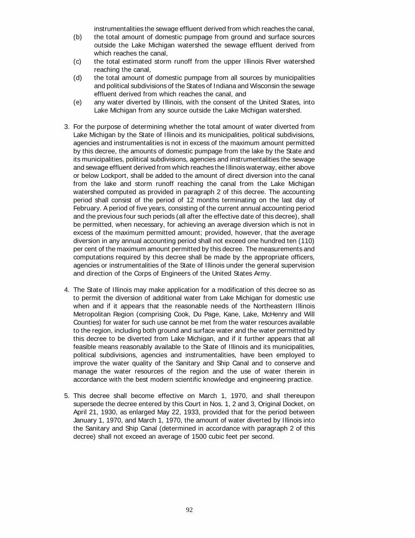
instrumentalities the sewage effluent derived from which reaches the canal,(b) the total amount of domestic pumpage from ground and surface sources
outside the Lake Michigan watershed the sewage effluent derived fromwhich reaches the canal,
(c) the total estimated storm runoff from the upper Illinois River watershedreaching the canal,
(d) the total amount of domestic pumpage from all sources by municipalitiesand political subdivisions of the States of Indiana and Wisconsin the sewageeffluent derived from which reaches the canal, and
(e) any water diverted by Illinois, with the consent of the United States, intoLake Michigan from any source outside the Lake Michigan watershed.
3. For the purpose of determining whether the total amount of water diverted fromLake Michigan by the State of Illinois and its municipalities, political subdivisions,agencies and instrumentalities is not in excess of the maximum amount permittedby this decree, the amounts of domestic pumpage from the lake by the State andits municipalities, political subdivisions, agencies and instrumentalities the sewageand sewage effluent derived from which reaches the Illinois waterway, either aboveor below Lockport, shall be added to the amount of direct diversion into the canalfrom the lake and storm runoff reaching the canal from the Lake Michiganwatershed computed as provided in paragraph 2 of this decree. The accountingperiod shall consist of the period of 12 months terminating on the last day ofFebruary. A period of five years, consisting of the current annual accounting periodand the previous four such periods (all after the effective date of this decree), shallbe permitted, when necessary, for achieving an average diversion which is not inexcess of the maximum permitted amount; provided, however, that the averagediversion in any annual accounting period shall not exceed one hundred ten (110)per cent of the maximum amount permitted by this decree. The measurements andcomputations required by this decree shall be made by the appropriate officers,agencies or instrumentalities of the State of Illinois under the general supervisionand direction of the Corps of Engineers of the United States Army.
4. The State of Illinois may make application for a modification of this decree so asto permit the diversion of additional water from Lake Michigan for domestic usewhen and if it appears that the reasonable needs of the Northeastern IllinoisMetropolitan Region (comprising Cook, Du Page, Kane, Lake, McHenry and WillCounties) for water for such use cannot be met from the water resources availableto the region, including both ground and surface water and the water permitted bythis decree to be diverted from Lake Michigan, and if it further appears that allfeasible means reasonably available to the State of Illinois and its municipalities,political subdivisions, agencies and instrumentalities, have been employed toimprove the water quality of the Sanitary and Ship Canal and to conserve andmanage the water resources of the region and the use of water therein inaccordance with the best modern scientific knowledge and engineering practice.
5. This decree shall become effective on March 1, 1970, and shall thereuponsupersede the decree entered by this Court in Nos. 1, 2 and 3, Original Docket, onApril 21, 1930, as enlarged May 22, 1933, provided that for the period betweenJanuary 1, 1970, and March 1, 1970, the amount of water diverted by Illinois intothe Sanitary and Ship Canal (determined in accordance with paragraph 2 of thisdecree) shall not exceed an average of 1500 cubic feet per second.
92
6. The complaint of the State of Illinois in No. 11, Original Docket, on behalf of itsinstrumentality, the Elmhurst-Villa Park-Lombard Water Commission, is herebydismissed, without prejudice to that Commission sharing in the water permitted bythis decree to be diverted from Lake Michigan.
7. Any of the parties hereto may apply at the foot of this decree for any other orfurther action or relief, and this Court retains jurisdiction of the suits in Nos. 1, 2and 3, Original Docket, for the purpose of making any order or direction, ormodification of this decree, or any supplemental decree, which it may deem at anytime to be proper in relation to the subject matter in controversy.
8, All the parties to these proceedings shall bear their own costs. The costs andexpenses of the Special Master shall be equally divided between the plaintiffs asa group and the defendants as a group in Nos. 1, 2 Original Docket. The costs andexpenses thus imposed upon the plaintiffs and defendants shall be borne by theindividual plaintiffs and defendants, respectively, in equal shares.
93


Appendix J
CORRESPONDENCE REGARDING FURTHER STUDIES
The Commission in the course of its deliberationsrecognized it could not fully answer all the questionsraised in the Reference. Consequently, on May 23,1975, the Commission sent the following letter to theGovernments of Canada and the United States.
The International Great Lakes Levels Board, in itsreport to the International Joint Commission datedDecember 7, 1973, found that preliminary plans for thecombined regulation of Lakes Superior, Erie and Ontarioexhibited favourable benefit-cost ratios. One of the plans,SEO-42P, suggested the concept of employing the BlackRock Canal to increase Lake Erie outflows during periodsof above-average supply. The Board concluded thatfurther study was needed of alternatives for regulatingLake Erie, taking into account the full range of watersupplies received to date.
The Commission has conducted thirteen publichearings throughout the Great Lakes Basin in Canadaand the United States to obtain comments on the Board'sreport and to provide opportunity for all levels ofgovernment, for interested organizations, and forconcerned individuals to express their views on furtherregulation of the Great Lakes.
Before the Commission can fully answer all thequestions raised in the Governments' 1964 Reference,additional studies are required. The Commission's reportto Governments, which is now in preparation, will explainin detail the need for additional information and data.The purpose of this letter is to inform the twoGovernments, in advance of the report, of the necessityfor the specific further studies indicated below and torequest support for these studies.
During the course of the hearings, the North CentralDivision, Corps of Engineers, presented a regulation plan,SEO-17P, as an extension of the studies documented inthe Board's report and utilizing the concept of diversionthrough the Black Rock channel. The Commission notesthat neither the Board's investigation of SEO-42P nor theCorps report on SEO-17P adequately cover theenvironmental aspects nor adequately define the netbenefits of such regulation.
Record water supplies during 1972-74 caused veryhigh levels on Lake Ontario and in the St. Lawrence Riverand severe erosion and flooding of the shoreline. Thepresent physical dimensions of the St. Lawrence Riverlimit the possible variation of flows above and belowthose selected for design purposes. An investigation ismandatory to ascertain what measures, if any, would berequired in the International Section of the St. LawrenceRiver to accommodate increased flows during the normalnavigation season and during the very critical period offorming and stabilizing an ice cover.
In recent years that portion of the St. Lawrence Riverlying in Canada has also been subject to persistent highflows and accompanying high water levels. The
Commission is aware that the Governments of Canadaand Québec have undertaken studies which areaddressed to the problems of coping with such highflows. The Commission is hopeful that the studies willsatisfy its need for information on the practicability ofimproving the regulation of Lake Ontario and providingadditional flexibility in the possible regulation of LakeErie. The availability of the scope of such studies, andinformation as to the progress and findings, would bevery useful to the Commission in the planning of itsinvestigation.
The Commission intends to establish a new Board,drawn from appropriate agencies in both countries tocarry out and coordinate the necessary investigations inthe Great Lakes and the International Rapids Section ofthe St. Lawrence River. In order to accomplish the workexpeditiously, the Commission requests that theGovernment of Canada and the Government of theUnited States provide not only adequate and timelyfunding, but also the required manpower resources.
In the event that the two Governments indicate to theCommission a general agreement regarding theadditional studies mentioned in the precedingparagraphs, the Commission will initiate the furtherinquiry as quickly as possible.
The Under Secretary of State for the Governmentof Canada responded in a letter dated September 26,1975. It is quoted below.
I am replying to your letter of May 23, 1975, in whichyou identify a need for additional studies in order toassist the Commission in answering all questions raisedby the Government's 1964 Reference on the regulationof the water levels of the Great Lakes.
I note that these studies would be intended to providefurther information on the environmental aspects and thenet benefits of possible regulation by diversion throughthe Black Rock Channel, and to ascertain what measures,if any, would be required in the International Section ofthe Saint Lawrence River to accommodate increasedflows at certain periods of the year. We appreciatehaving received advance information about the generalnature of the proposed studies. I note, however, that theCommission is preparing its final report to Governmentswhich will explain in detail the need for additionalinformation and data. The Government of Canada,therefore, would prefer to await submission of this reportbefore reaching any conclusions on the matter.
As you are aware, it has now been eleven years sinceGovernments referred the question of regulation to theCommission. The Government of Canada feels obliged toexpress its reservation as to the need to prolong the1964 Reference under present circumstances. We hope,therefore, that the Commission will now proceed tocomplete its work under the 1964 Reference to assistGovernments in reassessing the current situation.
95

This being said, we recognize that Governments, afterhaving had an opportunity to study the Commission'sfinal report under the 1964 Reference, may wish toconsider the possibility of giving the Commission afurther mandate with regard to Great Lakes water levels.Moreover, the Government of Canada would also wish toexamine the results of the studies currently beingundertaken by the Governments of Canada and Québecconcerning the problems of coping with high flows onthat portion of the St. Lawrence River lying entirelywithin Canada when considering such a further mandate.
A copy of this letter is being sent to the United StatesDepartment of State.
Similarly, the Deputy Assistant Secretary forCanadian Affairs for the Government of the UnitedStates replied in a letter also dated September 26,1975, but received a month later. It is quoted below.
The United States Government has given carefulconsideration to the proposals forwarded in your letter of
May 23 with respect to further studies by theCommission of means of improving the regulation of theGreat Lakes.
The United States Government believes that thestudies proposed in your letter have merit, and isprepared, subject to the normal reservations, to provideadequate funding and manpower for joint studies.Informal consultations with the Government of Canadaindicate that the Government of Canada would favorconsidering the question of further studies after theCommission's pending report on Great Lakes regulationhas been completed and can be reviewed. In view of theCanadian position, the United States Government wouldsuggest that, as indicated in your letter, the Commissionexplain in detail in its report to Governments the need foradditional information and data and the reasons why theCommission believes that the proposed studies would bein the common interest of both Governments. Such anaction on the part of the Commission would, we believe,be of considerable value to the Governments in theirfuture discussions concerning this matter.
96