full report - city of pittsburgh
TRANSCRIPT

Table of Contents
Acknowledgements
Recommendations
Oakland Strategic Visioning Process 1i Past Planning Effortsii The Future of Oakland:
A Community Investment Strategy
Summary of Issues 7
Urban Design Analysis 12i Existing Conditionsii Institutional Master Plansiii Other Master Plans and Studiesiv Concurrences, Conflicts, and Gapsv Areas of Opportunity
Transportation Analysis 47i Transportation Issuesii Transportation Guiding Principlesiii Transportation Alternatives
Benchmarking Summary 67i Lessons from Benchmarking Tripsii Conclusions from Quantitative Benchmarking
Recommended Projects 77Introduction
a Create a Sense of Place in Oaklandb Make it Easier to Get Into
and Around In Oaklandc Stimulate Neighborhood Revitalizationd Foster Technology Development
Project Charts

The Future of Oakland
Acknowledgements
Mayor
Tom Murphy
Pittsburgh City Council
Gene Ricciardi
President
Barbara Burns
Twanda Carlisle
Jim Ferlo
Alan Hertzberg
Jim Motznik
Bob O'Connor
Bill Peduto
Sala Udin
Oakland Task Force Member
Organizations
Carlow College
Carnegie Mellon University
Carnegie Museums of Pittsburgh
Carnegie Library of Pittsburgh
Children's Hospital
City of Pittsburgh
Magee Womens Hospital
Oakland Business Improvement District
Oakland Community Council
Oakland Planning and Development
Corporation
Oakland Transportation Management
Association
Phipps Conservatory and Botanical
Gardens
Pittsburgh Board of Public Education
Pittsburgh Parks Conservancy
Pittsburgh Playhouse of
Point Park College
Port Authority of Allegheny County
Public Parking Authority of Pittsburgh
Regional Industrial Development
Corporation
University of Pittsburgh
UPMC Health System
Western PA School for Blind Children

The Future of Oakland
The Oakland Task Force Investment
Strategy Committee
Linda Antonelli,
Magee-Womens Hospital
Richard Benfer,
UPMC Health System
David Blenk,
Oakland Planning and Development
Corporation
Anthony Boule,
Public Parking Authority of Pittsburgh
Kathy Boykowycz,
Oakland Community Council
Ellen Brooks,
Allegheny Conference on Community
Development
Meg Cheever,
Pittsburgh Parks Conservancy
Reynolds Clark,
University of Pittsburgh
Craig Dunham,
Carnegie Museums & Library of Pittsburgh
Caren Glotfelty,
The Heinz Endowments
Susan Golomb,
Director, City of Pittsburgh
Department of City Planning
Patrick Hassett,
City of Pittsburgh
Department of City Planning
Quahana Hendree,
Carnegie Museums & Library of Pittsburgh
Maureen Hogan,
City of Pittsburgh
Department of City Planning
Ralph Horgan,
Public Parking Authority of Pittsburgh
Sidney Kaikai,
City of Pittsburgh
Department of City Planning
Kevin Lamb,
Carnegie Mellon University
Bob Lurcott,
Richard King Mellon Foundation
Fred Mergner,
Port Authority of Allegheny County
Mavis Rainey,
Oakland Transportation Management
Association
Bob Reppe,
City of Pittsburgh
Department of City Planning
Jim Sherry,
Carlow College
Eli Shorak,
University of Pittsburgh
Alecia Sirk,
Oakland Business Improvement District
Paul Supowitz,
University of Pittsburgh
Paul Tellers, Chairman
Carnegie Mellon University,
Oakland Task Force Chairperson
John Wilds,
University of Pittsburgh
Wanda Wilson,
City of Pittsburgh
Department of City Planning

The Future of Oakland
Allegheny Conference on
Community Development
Oakland Investment Committee
Ellsworth H. Brown, Ph.D.
President, Carnegie Museums & Library of
Pittsburgh
Jared L. Cohon, Ph.D.,
President, Carnegie Mellon University
Maxwell King,
Executive Director,
The Heinz Endowments
Mark A. Nordenberg,
Chancellor and CEO,
University of Pittsburgh
Jeffrey Romoff,
President, UPMC Health System
Markos I. Tambakeras, Chairman
Chairman, President, and CEO,
Kennametal, Inc.
Michael Watson,
Vice President and Director,
Richard King Mellon Foundation
Consultant Team
Urban Design Associates
Lead Consultant
Glatting Jackson Kercher Anglin Lopez
Rinehart, Inc.
Transportation Consultant

The Future of Oakland
Recommendations
The Future of Oakland: A Community Investment Strategy
The goal of The Future of Oakland is to support the continuing growth of Oakland
as:
• an international center for research, education, healthcare, and culture
• a magnet for technology-based entrepreneurial activity
• an outstanding mixed-income urban residential neighborhood
• a cosmopolitan commercial district with local character
• a place that nurtures and celebrates creativity and diversity
• a destination for local, national, and international visitors
In short, to make Oakland a Great Place.
In January 2002 the Oakland Task Force developed a list of projects for the future of
Oakland in the following five categories: Quality of Life, Appearance, and Ameni-
ties; Development; Housing; Retail; and Transportation.
Many of the projects overlap in these five categories and also fulfill more than one
aspect of the goal for Oakland. One example is Schenley Plaza, which is both a qual-
ity of life and a transportation project. Some projects, such as light rail transit, will
require additional studies. Some projects can proceed immediately, such as improved
housing code enforcement. Others are longer term, such as a neighborhood elemen-
tary school. All are important. However, not all can be tackled at once. All of the
projects are detailed in the Recommended Projects section at the end of this report.
Given the variety of the projects, a central task of the Oakland Task Force was to
review each one and to develop a coordinated strategy, or road map, which funders
and implementers, both public and private, can use to focus investments in the near
term while understanding how all projects fit within the overall strategy. The intent
is to maximize the impact of each individual project through its synergy with other
projects.

The Future of Oakland
The means to accomplish this maximum impact is through four initiatives which
have emerged from the Oakland Task Force’s planning process for The Future of
Oakland. Each initiative is a combination of projects, programs, and studies. All are
essential as part of the larger strategy for The Future of Oakland.
1 Create a Sense of Place in Oakland
2 Make it Easier to Get Into and Around In Oakland
3 Stimulate Neighborhood Revitalization
4 Foster Technology Development
These four initiatives are summarized in the text below and are located geographi-
cally on maps which follow.
Initiative 1 – Create a Sense of Place in Oakland
There is no central “there” in Oakland, no town green, no central gathering place,
and no sense of arrival.
The following projects, when combined, will make a “there” in Oakland:
• redesign and program Schenley Plaza as an active public plaza and gathering
place, including new traffic patterns and parking management programs
• upgrade the appearance and function of three of the gateways to Oakland
(Western Gateway below Craft Avenue, Southern Gateway at Bates Street,
and Northern Gateway at North Craig Street)
• make Forbes Avenue into a pedestrian-friendly traditional, commercial main
street that links the universities and Schenley Plaza
• upgrade streetscapes in the retail areas and attract new businesses consistent
with market studies and retail recruitment strategies already completed with
particular emphasis on Forbes Avenue
• expand the Oakland Business Improvement District (OBID) to include the
Atwood Street, North Craig Street/Centre Avenue, and South Craig
Street business districts
• create a “Cultural Trust” type of organization to energize, promote,
and market the cultural attractions and night life of Oakland
• develop a pedestrian plan for Oakland that prioritizes pedestrian safety and
addresses “pedestrian cold spots,” improves dangerous intersections, and
helps people get around on foot with way finding signage

The Future of Oakland
Initiative 2 – Make it Easier to Get Into and Around In Oakland
Oakland is the third largest commuter destination in Pennsylvania, after downtown
Philadelphia and downtown Pittsburgh. With 50,000 workers, students, visitors, and
patients arriving every day, access to Oakland is of paramount concern.
There are perceptions of both traffic congestion and “nowhere to park” in Oakland.
In fact, the traffic and parking problems in Oakland pale by comparison with most
downtowns. Nevertheless, there are internal mobility problems within Oakland
which are susceptible to remediation within a coordinated transportation strategy.
Attraction of new technology development is highly dependent on a public trans-
portation system which is ubiquitous and easy to use (such as frequent internal shut-
tles) and traffic and parking systems which are efficient and easy to navigate.
Retention of students post-graduation is also dependent on outstanding public tran-
sit from Oakland to other parts of the city. Their principal means of exploration
while students is on public transit. Once students explore the region, they are more
likely to want to stay.
The projects listed below will make it easier to get into and around in Oakland:
• develop rapid transit service from Downtown to Oakland, including
ultimately the extension of light rail transit from Downtown to Oakland
• increase direct bus routes from other regional areas to Oakland
• develop fringe/intercept parking facilities for commuters
• develop a bike trail head near Schenley Plaza and bike lanes on arterial streets
• develop an integrated multi-modal strategy for managing traffic, transit,
bicycles, and pedestrian needs on Fifth and Forbes Avenue in the heart of
Oakland and for addressing traffic “hot spots,” particularly lower Bates Street
at the Boulevard of the Allies, Forbes/Fifth as one or two way streets, and
Bigelow Boulevard/ Bellefield area traffic circulation
• determine the feasibility of a universal shuttle bus system for Oakland,
including connections to the riverfront and other key areas, such as
fringe/intercept parking
• develop a comprehensive parking management plan for Oakland that
would maximize the use of spaces

The Future of Oakland
Initiative 3 – Stimulate Neighborhood Revitalization
Many of the residential neighborhoods of Oakland are in stress, especially Central
Oakland, not only from the pressures of off-campus student housing and absentee
landlord neglect, but also from the lack of significant new investment in housing.
Retaining current residents and attracting new families and workers to live in Oak-
land requires upgrading of the housing stock and investing in neighborhood
amenities.
The following projects, when combined, will stimulate neighborhood revitalization:
• develop high quality single-family and multi-family housing in Central
Oakland through the Oakland Planning and Development Corporation, in a
mix of rehab and new construction
• strengthen existing and develop new housing financing programs to provide
incentives for purchasing homes in Oakland, to provide financing assistance
for facade improvements, and to finance Oakland Planning and
Development Corporation's purchase of additional homes as they come on
the market.
• strengthen the code enforcement program in residential neighborhoods
• provide incentive programs for rental property owners to improve their
properties
• begin a planning process with the Pittsburgh Public Schools for the location
and construction of a new elementary school in Central or South Oakland
Initiative 4 – Foster Technology Development
Oakland is the economic wellspring of the future economic growth of the region
because of its concentration of researchers at the universities and hospitals, and the
potential for spin-off companies. Experience teaches that spin-off companies tend to
locate near the talent and laboratories of the researchers, and that existing technology
companies from outside the region are also attracted to locations near researchers and
universities.
The Future of Oakland
These private development efforts need to be coordinated with the plans of the
major institutions in Oakland because the growth and strength of the research uni-
versities and hospitals are essential to new technology development.
These projects below, when combined, will foster technology development:
• conduct a financial feasibility analysis of the Western Gateway opportunity
area and consider urban design and development connections to vacant
properties at the Boulevard of the Allies and Craft Avenue
• conduct a land use, urban design, and development feasibility study for
Junction Hollow with the residents and property owners to identify
development opportunities
• conduct a land use, urban design, and development feasibility study for
technology development in North Oakland in the area of North Craig Street
and Centre Avenue
• conduct a land use, urban design, and development feasibility study for
technology development for the multi-block area bounded by Fifth/Forbes
and Bellefield/South Craig
• explore the feasibility of developing a university inn and conference center
with associated retail and restaurants
• coordinate technology development efforts with plans being developed for
the vacant Hazelwood LTV site and the Baum Boulevard/Centre Avenue
corridor

©20
02
ur
ba
n d
esi
gn
ass
oc
iat
es
Create a Sense of Place in Oakland
Schenley Plaza
Business Districts
Gateways
• Redesign and program Schenley Plaza as an active
public plaza and gathering space
• Redesign and program new traffic patterns and
parking management
• Upgrade streetscapes in the retail areas; attract new
businesses consistent with market studies and
retail recruitment strategies already completed,
with particular emphasis on Forbes Avenue
• Expand the OBID to include the Atwood Street,
North Craig Street/Centre Avenue, and South
Craig Street business districts
• Upgrade the appearance and function of the three
gateways to Oakland:
Western Gateway below Craft Avenue
Southern Gateway at Bates Street
Northern Gateway at North Craig Street
Connector
• Make Forbes Avenue into a pedestrian-friendly
traditional commercial main street that links the
universities and Schenley Plaza
Western Gateway
Northern Gateway
Southern Gateway
Fifth
Avenue
Forb
esAve
nue
Boulevard of the Allies
Atw
oodStreet
Cra
igS
treet
Monongahela River

©20
02
ur
ba
n d
esi
gn
ass
oc
iat
es
Make it Easier to Get Into and Around In Oakland
ParkingCity Connectors
Hot SpotsRegional Connectors
Regional Connectors
Hot Spots
City Connectors
• Increase direct bus routes from other regional
areas to Oakland
• Develop an integrated multi-modal strategy for
managing traffic and addressing the following
traffic “hot spots”:
Bates Street at the Boulevard of the Allies and
I-376
Fifth/Forbes Avenues as one or two way
streets
Bigelow Boulevard/Bellefield area traffic
circulation
• Develop a light rail extension from Downtown to
Oakland
• Determine the feasibility of a shuttle bus system
for Oakland with connections to the riverfront
and other key areas
• Develop a bike trail head near Schenley Plaza
• Develop bike lanes on arterial streets
Parking
• Develop fringe/intercept parking facilities for
commuters
• Develop a comprehensive parking management
plan for Oakland
Fifth
Avenue
Forb
esAve
nue
Cra
igS
treet
SecondAvenue
Fifth
Avenue
Forb
esAve
nue
Boulevard of the Allies
Belle
field
Monongahela River
Monongahela River
KeyLRT Link
Bike Lanes
Bike Trail Head
Fifth
Avenue
Forb
esAve
nue
Boulevard of the Allies
Belle
field
Bigelow
Second Avenue
Bate
sS
treet
Monongahela River

©20
02
ur
ba
n d
esi
gn
ass
oc
iat
es
Stimulate Neighborhood Revitalization
Central Oakland
Housing Programs
• Develop improved single-family and multi-family
housing for renters and homeowners in Central
Oakland through rehab and new construction
• Strengthen existing housing improvement pro-
grams through the Oakland Planning and
Development Corporation, including rehab and
new housing project funding
• Strengthen the code enforcement program in resi-
dential neighborhoods
• Provide incentive programs for absentee landlords
to improve their properties
North Oakland
Central Oakland
West Oakland
South Oakland
Fifth
Avenue
Forb
esAve
nue
Boulevard of the Allies
Cra
igS
treet
Monongahela River
Neighborhood boundaries according to
Department of City Planning

©20
02
ur
ba
n d
esi
gn
ass
oc
iat
es
Foster Technology Development
Potential Technology Development
Links
• Conduct appropriate land use, urban design and
development feasibility studies for:
Western Gateway
Junction Hollow
North Oakland
Fifth/Forbes, South Craig/Bellefield Blocks
• Coordinate technology development efforts with
other emerging initiatives:
Pittsburgh Technology Center (PTC)
Hazelwood LTV Site (LTV)
Baum Boulevard/Centre Avenue Corridor
• Create a shuttle bus system to connect the tech-
nology developments
LTV
Fifth
Avenue
Forb
esAve
nue
Boulevard of the Allies
Cra
igS
treet
Belle
field
Baum Boulevard
Second AvenueMonongahela River
No
rthC
raig
Stre
et
CentreAvenue
PTC
Baum/Centre
Corridor
North Oakland
Western GatewayJunction Hollow
Fifth/Forbes;
South Craig/
Bellefield
Blocks

The Future of Oakland
Oakland StrategicVisioning Process
1

The Future of Oakland
oakland has been planned and studied extensively since
its beginnings as a pioneering Pittsburgh suburb in the late
19th Century, stimulated first by horse drawn streetcars in the
1870's and later by electric streetcars in the 1890's. The dona-
tion of Schenley Park by Mary Schenley Croghan 1889 and
Andrew Carnegie's gifts of the Carnegie Museum, Music Hall,
and Library (1905), and Carnegie Institute of Technology
(1906) were major events in the evolution of Oakland as the
region's second civic center. The move of the campus of the
University of Pittsburgh to Oakland in 1908 and the construc-
tion of Magee Hospital in 1912 further solidified Oakland as
an institutional center. Finally, the City Beautiful master plan
by private developer Franklin Nicola set the pattern for private
development and established a beautiful framework of streets
and civic buildings.
Oakland continued its development of gracious neighbor-
hoods and elegant institutional and public buildings (Cathedral
of Learning, Soldiers and Sailors Memorial, Forbes Field, etc.)
throughout the first third of the 20th century. The Depression
and World War II interrupted development. In the 1960's
institutional growth picked up again and for the first time
there were conflicts between the institutions and neighbor-
hoods. The first community wide public participation plan for
Oakland was developed in 1979 by Urban Design Associates
to resolve conflicts over land use and transportation and to plan
for the future. A consensus steering committee group, Oakland
Directions, Inc. (ODI), an organization of neighborhood
organizations with University of Pittsburgh and Health Center
representatives, met regularly during the planning process to
discuss development. In the Early 1980s, Mayor Richard
Caliguiri formed the Oakland Task Force (OTF) which is
comprised of institutional, government and community repre-
sentatives, and has been functioning as the “United Nations” of
Oakland for over twenty years.
i Past Planning Efforts 2
The Future of Oakland
Since 1979 a number of community
plans have been produced, including:
• Oakland Issue Paper (1994) which
proposed several urban design con-
cepts for Oakland (Second Down-
town; a Neighborhood; a Campus;
and Pittsburgh's “Left Bank”);
• Oakland Neighborhood Housing
Strategy and Housing Market Study
(1995 and 1997) which were the
basis of the Oakland Improvement
Strategy (OIS) and were appendices
to the OIS;
• Oakland Improvement Strategy
(OIS) (1998), an “action agenda”
with a strong focus on housing
issues, code enforcement, and the
retail areas;
• Comprehensive Real Estate Devel-
opment Strategy (2001), prepared by
the Oakland Planning and Develop-
ment Corporation (OPDC), which
also focused on housing issues such
as increasing home ownership, rehab
and new construction, and relocating
students from neighborhood hous-
ing;
• Oakland New Economy Connec-
tions (2001), a graduate student
study by Carnegie Mellon University
for OPDC which looked at the
opportunities for technology growth
in Oakland but in context with
neighborhood and community goals;
and
• Master Development Planning in
Hazelwood and Junction Hollow
(2001), a City of Pittsburgh spon-
sored public participation planning
process which examined the LTV
site, neighborhood and business dis-
trict revitalization, connections to
Oakland, and the impact of the
Mon-Fayette Tollway.
In addition, two major transportation
studies have been produced:
• Mid-range transportation study
(1994) which looked at a number of
transportation proposals for Oakland
and their effects.
• Bates Street/Allies Corridor study
(1994) which evaluated alternative
configuration of the Allies/Bates
street intersection and their effect on
reducing traffic in Central Oakland.
In the last ten years several institutional
master plans have been completed,
including:
• University of Pittsburgh Master
Space Plan (1994);
• University of Pittsburgh Facilities
Master Plan (1998-2007);
• University of Pittsburgh Medical
Center Master Plan (2001);
• Carnegie Mellon University Master
Plan (2002).
Other institutional master plans are
under development for the Carnegie
Museums and Library of Pittsburgh,
Phipps Conservatory, and Carlow
College.
3

4
The Future of Oakland
In addition, a number of special pur-
pose plans in Oakland or affecting Oak-
land have been developed or are
underway, including:
• The Oakland Civic District Loop
(2001) by OTF to develop a consen-
sus vision for Schenley Plaza and
environs;
• Pittsburgh's Regional Parks Master
Plan (2001), prepared for the City of
Pittsburgh and the Pittsburgh Parks
Conservancy, which included a mas-
ter plan for Schenley Park;
• Forbes Avenue Streetscape Standards
(2001), design standards prepared for
the Oakland Business Improvement
District (OBID);
• Forbes Avenue - Boulevard of the
Allies “Gateway Bridge” Project
(2002), an OTF sponsored engineer-
ing and aesthetic study of the over-
pass bridge replacement at the west
portal to Oakland; and
• Oakland Western Gateway Portal
(2002), an urban design study of the
development sites at the western por-
tal to Oakland prepared for OPDC.

The Future of Oakland
in 2001 the oakland task force (OTF) was approached by
the Allegheny Conference on Community Development
(ACCD) to assist in preparing a Strategy Plan for the Future
of Oakland which would focus on getting plans and projects
moving forward that have consensus approval and funding.
The ACCD, which is an organization of the CEOs of the
major corporations, institutions, and foundations in the Pitts-
burgh region, had identified Oakland as a key initiative area for
economic revitalization of Southwestern Pennsylvania.
A document, Strategy for the Future of Oakland, prepared
in January 2002 by the OTF and assisted by ACCD staff, doc-
umented a number of projects underway, pending, or in plan-
ning in the following five categories: Quality of Life,
Appearance, and Amenities; Development; Housing; Retail;
and Transportation. Projects were categorized as Quick Hits,
Ready to Go, or Requires Further Study.
The Strategy for the Future of Oakland was then presented
to the Oakland Investment Committee (OIC), made up of the
four CEOs of the University of Pittsburgh, UPMC Health
System, Carnegie Mellon University, and Carnegie Museums
of Pittsburgh and Carnegie Library, the Mayor of the City of
Pittsburgh, and the heads of the Mellon and Heinz family
foundations. The OIC is chaired by Markos Tambakeras,
CEO of Kennametal, a board member of the ACCD.
The OIC, and later the OTF, determined that the Strategy
for the Future of Oakland, although detailed in its listing of
projects, did not constitute a coordinated plan for action. It was
determined that an additional concentrated planning process
was required to pull the various projects into a more compre-
hensive strategy.
Urban Design Associates was retained in May 2002 to lead
the OTF and OIC through that next step in the summer of
2002. This report, The Future of Oakland: A Community
Investment Strategy, is the result of that effort.
ii The Future of Oakland:A Community Investment Strategy
5

The Future of Oakland
Goal
The goal of The Future of Oakland is to
support the continuing growth of Oak-
land as:
• an international center for research,
education, healthcare, and culture
• a magnet for technology-based
entrepreneurial activity
• an outstanding mixed-income urban
residential neighborhood
• a cosmopolitan commercial district
with local character
• a place that nurtures and celebrates
creativity and diversity
• a destination for local, national, and
international visitors
Central Theme
Oakland is considered to be the well-
spring of the future economic growth of
the region.
Its clear strengths are its institutions
(Carnegie Mellon University, Carnegie
Museums of Pittsburgh, Carnegie
Library, University of Pittsburgh,
UPMC Health System, and many oth-
ers). Oakland also has historic neighbor-
hoods, great classical buildings from the
City Beautiful era, good public transit,
and Schenley Park, a major city open
space resource.
Its weaknesses are a poor image in
“downtown” Oakland, some deteriorated
neighborhoods, parking and traffic
issues, internal land use conflicts and
competing interests, and the lack of land
for expansion of institutions and for pri-
vate development to retain, grow, and
attract technology companies.
Oakland, although strong overall, has
not reached its potential as a great place
to attract and retain talent and invest-
ment, especially alongside national com-
petition with regions with similar
strengths and goals.
Planning Process
The Future of Oakland had three interre-
lated and concurrent studies:
I Refine the Strategy for the Future of
Oakland ( January 2002) previously
developed by the Oakland Task
Force, including: a study of potential
linkages to adjacent and contiguous
areas; and a documentation and
review of the current and past master
plans of the major Oakland institu-
tions to assess their compatibility
with each other and with other ini-
tiatives. Over thirty individual inter-
views were conducted with major
stakeholders in Oakland.
II Conduct a national bench marking
survey of similar university/research/
creative communities. Three cities
were visited in July and August 2002
by an eleven person delegation from
Oakland: Cambridge, Massachusetts;
Austin, Texas; and Philadelphia,
Pennsylvania.
III Conduct a quantitative benchmark-
ing study of similar metropolitan
areas. Dr. Richard Florida of the
Heinz School of Public Policy of
Carnegie Mellon University led this
study, which, although independently
funded and produced, was coordi-
nated with the other two studies
above.
6

7
The Future of Oakland
Summary of Issues

8
The Future of Oakland DRAFT
Summary of Issues nearly all the ingredients are here for a great place: the
Oakland Task Force as a unifying planning forum; many great
institutions; good jobs; historic neighborhoods; a diverse popu-
lation; a great city park; good transit; and there have been
ongoing housing revitalization initiatives by the Oakland Plan-
ning and Development Corporation (OPDC) as well as the
recent formation of the Oakland Business Improvement Dis-
trict (OBID).
So what’s wrong? Why is Oakland not an economic devel-
opment hub? Why is it not a cool place? Why is it not a mag-
net for culture and social activity? Why do students and faculty
leave Oakland?
Some conclusions can be reached based on the analysis
process described in this report and on the two benchmarking
studies.

The Future of Oakland DRAFT
1 The Forbes Avenue commercial dis-
trict is mediocre at best, and falls far
short of what is needed or expected
in an university district.
2 The gateways to Oakland, except
from the east (from Shadyside), are
uniformly decrepit (Blvd. of the
Allies/Forbes Avenue, Bates Street,
and North Craig Street).
3 There is very little visual or pro-
grammatic connection to the great
resource of Schenley Park or to the
ever expanding trail system and out-
door resources of the city and region.
4 Beyond the boundaries of the well
maintained institutions, the whole
district looks run down and uncared-
for, except for a few pockets of excel-
lence, such as the Schenley Farms
neighborhood and the South Craig
Street retail district.
5 Technology businesses, to the extent
that they exist in Oakland, are invisi-
ble and seem to have no presence.
A coordinated strategy to grow or
attract such businesses and to
develop buildings is not apparent.
6 Although the Pittsburgh region
ranks in the top ten regions in the
United States in university students,
faculty, research grants, and patents
per capita, it ranks 49th in retention
of talent and 55th in job growth,
indicating an inability to capitalize
on its talent assets, which are prima-
rily located in Oakland.
9
Gateways
Bates Street at the
Boulevard of the Allies
Forbes Avenue
The Forbes Avenue
commercial district falls
short of what is
expected of university
districts.
Run-down District
Outside of the
institutions, much of
Oakland looks
unattractive and
unwelcoming

The Future of Oakland DRAFT
7 There is fragmentation: seven neigh-
borhoods separated from each other
and from the retail areas by institu-
tions, busy arterial roads, and topog-
raphy, four City Council districts,
four Public School Board Legislative
Districts, two State Legislative dis-
tricts and two State Senate districts,
institutional and community compe-
tition for public, private, and founda-
tion resources
8 Institutional expansion and commer-
cial development have eroded the
historic residential neighborhood
fabric, both by physical incursion
into the edges of the neighborhoods
and by market driven conversion of
family housing to substandard off-
campus student housing.
9 There is a continuing decline in the
number of families in Oakland due
primarily to the control of affordable
housing stock by absentee landlords
who purchase apartment buildings
and houses and subdivide them for
rentals to college students.
10 Neighborhood services and amenities
to attract and retain families are lack-
ing, such as appropriate stores and
shops for residents, an elementary
school, and children’s playgrounds.
11 The attractions of Oakland
(Carnegie Museums of Pittsburgh,
Carnegie Library, Carnegie Music
Hall, University of Pittsburgh
Nationality Classrooms, Stephen
Collins Foster Memorial, Heinz
Chapel, Soldiers and Sailors Memor-
ial, Phipps Conservatory, Pittsburgh
Playhouse, Schenley Park, and oth-
ers) are not packaged as a cultural
destination.
10
City Council
Districts
Oakland contains four
City Council Districts
Bill Peduto
Bob O’Connor
Sala Udin
Gene Ricciardi N

11
The Future of Oakland DRAFT
12 Transit service on buses to Oakland,
although good, is not a “good experi-
ence.”
13 There is a perception of “nowhere to
park.”
14 There is a perception of traffic con-
gestion.
15 There is a perception that much of
Oakland is pedestrian unfriendly.
16 There is a perception that Oakland is
a dangerous place.
17 There is no sense of where the heart
of the community is – a central place,
a town square.
18 There is very little celebration of
what Oakland was or is. There are
few, if any, art, street, or ethnic festi-
vals.
19 Although Oakland is not generally
seen as overtly hostile to racial and
sexual minorities, there are no spe-
cific programs or groups in place to
welcome immigrants or for minori-
ties to join.
20 Avant-garde places and activities,
which usually flourish in interna-
tional university districts as large as
Oakland are woefully under repre-
sented – things such as live music
venues, small playhouses and per-
formance spaces, art/foreign film
houses, private art galleries, inde-
pendent bookstores, independent
record stores, cafes and coffee shops,
internet cafes, ethnic restaurants,
sidewalk restaurants, gourmet restau-
rants, all night diners and restaurants,
gay/lesbian friendly businesses, out-
door stores, boutique clothing stores,
art supply and craft stores, computer
and software stores, street vendors,
and street performers.
Deteriorated
Housing Stock
Single family housing
in Oakland has been
converted to rental
apartments for students
and is not well
maintained.
12
The Future of Oakland
Urban Design Analysis

13
The Future of Oakland
in order to understand the urban form of Oakland and
the context of the various institutional master plans, Urban
Design Associates prepared a series of UDA X-Raystm. These
drawings extract layers of information from the existing land
use plans. Each layer of information (streets, residential and
commercial uses, institutions and open space, etc.) reveals pat-
terns that emphasize the design issues for the study area.
i Existing Conditions
Neighborhood
X-ray Diagram
The study area is
bounded by nine
neighborhoods and the
Monongahela River
and is more extensive
than the traditional
Oakland neighborhood
boundary.
N
Fifth Avenue
Big
elow
Blvd
Centre Avenue
Penn-Lincoln Pkwy
Bir
min
gh
am B
r
Hot Metal B
r
Fifth Avenue
Neville
Oakland
Squirrel Hill
Shadyside
Bloomfield
Lawrenceville
Polish Hill
Hill District
Crawford/Roberts
Bluff
Southside Flats
GreenfieldHazelwood
Alleghen
y Rive
r
Monongahela River

14
The Future of Oakland
Streets
The Oakland street pattern is discontinuous in
comparison to the regular grid of surrounding
neighborhoods. Among the reasons for this are the
large institutional blocks which interrupt the grid,
topography, and the shifted grid of streets related to
the layout of arterials and highways.
Figure Ground (Building Coverage)
The figure/ground, showing building footprints,
reveals a pattern of larger institutional buildings
clustered in the middle of Oakland. Smaller
footprints indicate residential uses distributed to
the north, south and, west. The remaining voids
are Schenley Park, the lawn around the Cathedral
of Learning, surface parking lots, and steep slopes.
N
N

15
The Future of Oakland
Institutions, Parks & Open Space
Institutional uses dominate Oakland. The resulting
density of students, staff and visitors creates
parking and traffic issues. The institutions also
separate residential neighborhoods in the north
from those in the south. With the exception of
Schenley Park, there is a lack of programmed public
open space, especially in the residential areas.
N
N
BIGELOW
BOULEVARD
FIFTH
AV
EN
UE
FORBES
AV
EN
UE
PARKWAY EAST
BOULEVARD OF THE ALLIES
CEN
TRE
AVENUE
CR
AIG
ST
RE
ET
ST
UD
YA
RE
AB
OU
ND
A
R Y
S T U D Y A R E AB O
U ND
A R Y
Institutions
Institutional Land
Institutional Open Space
Parks
Highways
Arterials
Highways & Arterials
Five major east/west arterial streets serve
Oakland: Boulevard of the Allies, Forbes Avenue,
Fifth Avenue, Centre Avenue, and Bigelow
Boulevard. North/south connections are less
frequent, thus the resulting traffic congestion on
street like Bates Street and Craig Street. The
Parkway East has two major exits in Oakland at
Boulevard of the Allies from the west, and Bates
Street from the east.
BA
TES

16
The Future of Oakland
Residential
The neighborhoods within the Oakland study area
are separated from each other by institutional uses.
The Shadyside, Bloomfield and Squirrel Hill
neighborhoods to the east, and the Hill District to
the west, have a mix of owner-occupied and rental
housing.
Commercial
Commercial uses in Oakland are primarily located
along Forbes Avenue and Craig Street. In the
adjacent neighborhoods, there is substantial
commercial development along Baum Boulevard,
Liberty Avenue and Carson Street.
N
N
Commercial Uses
Residential Uses
CARSON
FORBES
AV
EN
UE
BAUM
LIBERTY

17
The Future of Oakland
Transit in Oakland
Oakland is well served by buses in the east/west
direction (from Downtown to city neighborhoods
in the east). North/south bus lines are few and
connection to suburban neighborhoods are scarce.
The Martin Luther King, Jr. Busway provides
express service from Oakland to Downtown.
N
Parking in Oakland
There are a large number of parking lots and
structures, both public and private, in Oakland.
N
Bus lines
Parking Lots
Parking Structures
Busway

18
The Future of Oakland
Ownership Diagram
Institutions control large land parcels in Oakland.
N
Historic Buildings
Oakland, like so many of the Pittsburgh’s 19th
Century suburbs, contains a wealth of historic civic
and institutional buildings as well as historic
neighborhoods and houses.
N Historic Buildings
UPMC Health System
Carlow College
Carnegie Museums
Phipps Conservatory
University of Pittsburgh
Carnegie Mellon University
Other Institutions

19
The Future of Oakland
Buildings Developed since 1979
Institutions have built the majority of new
buildings in Oakland since 1979.
NNew Buildings since 1979
School Boards Districts
Four school board districts serve Oakland. Students
in North Oakland attend school with students from
the upper Hill District, Bloomfield and
Friendship; Students in South Oakland attend
school with students from Greenfield, Hazelwood
and the South Side; students in West Oakland
attend school with students from the middle Hill
District; and, students from Central Oakland
attend school with students from Shadyside and
Squirrel Hill. There is no neighborhood elementary
school in Oakland.
District 4, William Isler
District 5, Theresa Colaizzi
District 8, Mark Brentley, Sr.
District 3, Alex Matthews
N

20
The Future of Oakland
ii Institutional Master Plans uda collected master plan documents from the institu-
tions and from the City of Pittsburgh. Interviews were also
conducted with the CEOs, facilities directors, and planners of
the major institutions, and with the Pittsburgh Department of
City Planning. On the pages following are illustrations and
summaries of those master plans including:
• Carnegie Mellon University
• Carnegie Museums of Pittsburgh
• Carnegie Library of Pittsburgh
• University of Pittsburgh
• UPMC Health System
• Magee Women’s Hospital
• Carlow College
• Phipps Conservatory
• Veterans Administration Hospital

21
The Future of Oakland
Carnegie Mellon University
Completed in January of 2002, the mas-
ter plan for Carnegie Mellon University
established a 20-year campus plan that
creates sites for new buildings while
enhancing the quality and character of
the campus.
CMU’s campus is comprised of an
110 acre campus with four precincts:
West, East and South Campus and
North of Forbes.
Three main principles inform the
Master Plan:
1 Enhance quality of life as it pertains
to students, faculty/staff, and visitors
2 Further develop facilities to support
teaching and research
3 Create linkages to local and regional
economic developments: Panther
Continuing a Vision
Carnegie Mellon’s
Master Plan calls for
new academic and
student residence
buildings on current
University property,
and reinforces campus
spaces and connections
N
COURTESY: CARNEGIE MELLON UNIVERSITY
Hollow Development Corporation
Building on Forbes Avenue next to
the Heinz School, connections to
Craig Street Retail Corridor, and
improved Transportation Manage-
ment
The Master Plan has identified projects
for the four campus precincts, and for
Forbes Avenue:
North of Forbes
• Convert Morewood Parking Lot into
athletic fields, academic and admin-
istrative buildings, or housing.
• Reconfigure fraternity houses around
a campus green
• Build a “Visitor Center” at the corner
of Forbes and Morewood that would
also support student services and
offices
Forbes Avenue
Fifth Avenue

22
The Future of Oakland
• Identify future potential housing site
near Doherty apartments that would
include a 70-car garage
East Campus
• Build new housing on Roselawn site
and at the corner of Margaret Morri-
son and Forbes Avenue.
• Create small recreational field over
parking garage behind Donner Hall
• Improve Donner Hall facade
• Construct additional parking deck on
Gesling Stadium garage to provide
220 additional spaces
South Campus
• Build a combined gallery and confer-
ence space beneath garden
• Create entrance into Schenley Park
from across Frew Street
• Convert surface lots into garden
parks
Central Campus
• ‘Green’ the campus through the
removal of surface lots, limited vehi-
cle access, and the elimination of
most traffic to and from Forbes
Avenue
• Build new building to house collabo-
rative research with industry partners
and 288 parking spaces
Forbes Avenue
• Narrow Forbes to three lanes
through most of campus by narrow-
ing west bound lanes, eliminating
one of the through lanes between
Doherty Apartments and Beeler
Street, and by eliminating the left
turn lane at Beeler Street.
• Widen sidewalks
• Plant street trees
• Establish transportation manage-
ment office
• Reduce Single Occupancy Vehicle
(SOV) usage through transportation
management
• Close a West Campus street
• Build garages to allow for removal of
surface lots
Summary of Ten Year Plan
(28 buildings total)
• Residential: 378,000 sf with a poten-
tial for an additional 100,000 sf
• Academic/Research: 546,000 sf
• Administrative: 110,000 sf
• Office/Retail: 28,000 sf
Additional Initiatives
Portals and Image
• Improvements to all portals: Forbes
at the east and west end of campus,
Morewood near Fifth, and on Frew
Street near GSIA and Scaife Hall
• Craig Street
• Collaborate with neighborhood to
give Oakland more of a college town
quality
• Enhance Craig Street as a main link
to the campus
• Draw upon an imagery for Craig
Street as a mini Harvard Square

23
The Future of Oakland
Carnegie Museums of Pittsburgh and
the Carnegie Library of Pittsburgh
The Carnegie Museums of Pittsburgh
and the Carnegie Library of Pittsburgh
are in the process of submitting an Insti-
tutional Master Plan to the City Plan-
ning Commission in fall 2002. The two
institutions have developed common
goals for the master plan which are listed
below.
Goals
1 Strengthen the Carnegie Museums
and Library complex as the cultural
and civic center of Oakland.
2 Simplify and clarify points of entry,
pedestrian circulation, parking, and
transit for museum and library visi-
tors.
3 Provide flexibility for future expan-
sion of museum exhibit galleries and
curatorial, research, education, and
storage space.
4 Utilize the Panther Hollow Develop-
ment Corporation project to comple-
ment the image and enhance the
mission of the Carnegie Museums
and Library.
5 Emphasize public art and landscape
design. Schenley Plaza must become
a great public space.
6 Link the campus to the other institu-
tions in Oakland, such as the Univer-
sity of Pittsburgh, Carnegie Mellon
University, Phipps Conservatory, and
Schenley Park and to the city-wide
parks and trail system.
7 Resolve traffic and transit issues,
such as school bus staging on Forbes
Avenue and the traffic patterns on
Forbes, Craig, and Bellefield.
8 Develop a parking strategy for visi-
tors and staff, including convenient
short term parking for the library.
Ten Year Development Program
Initiatives
1 Build new 26,000 square foot
Entrance Pavilion on Forbes Avenue
to include ticketing, museum store,
gallery space, and conference room
2 Build a 15,000 square foot Dinosaur
Hall atrium for Carnegie Museum of
Natural History

24
The Future of Oakland
3 Build a 20,400 square foot addition
for collections and research for
Carnegie Museum of Natural His-
tory
4 Remodel Carnegie Library Space
5 Add seventeen new short-term park-
ing lot spaces North of Schenley
Drive.
6 Build Phase I of Panther Hollow
Development Corporation Building,
including 250,000 to 300,000 square
foot of office/research uses.
7 Build Panther Hollow Development
Corporation Parking Garage, to pro-
vide parking for 750 cars, and server
office and research uses.
8 Reconfigure Carnegie Museum of
Art loading dock.
9 Retrofit Boiler Plant with more effi-
cient gas-burning boilers.

25
The Future of Oakland
University of Pittsburgh
The University of Pittsburgh has pre-
pared several planning documents over
the last ten years, which build upon one
another. Together they constitute the
University’s Master Plan.
Summarized here are the Master
Space Plan Transportation Study Final
Report (May 95); Facilities Plan 1998-
2007 (Apr 97); Master Plan 1998 Park-
ing Plan Executive Summary;
Comprehensive Housing Strategy ( Jun
98, Apr 99); and Revised Master Plan
(Upper Campus Component) (2000,
undated)
Project initiatives in the University of
Pittsburgh’s Master Plan fall into three
primary categories:
1 Education and research
2 Student Life
3 TransportationNew Housing
A major thrust of The
University of
Pittsburgh’s Master
Plan is student housing
in the Upper Campus,
reducing student density
in Central Oakland
N
Peterson
Center
COURTESY: UNIVERSITY OF PITTSBURGH
Main Objectives
• Add 100,000 SF of book storage and
related space to Hillman Library
• Find additional high-density library
storage space at a nearby location
• Meet needs through aggressive reno-
vation to curtail costs
• Build 13-story Research Tower
(INB3) on the northeastern corner of
Fifth and Darragh for research by
UPMC
• Build enough housing to offer a
four-year housing guarantee and end
the housing lottery
• Build suite-style buildings popular
with upperclassmen, at F lot: eight-
story facility; at University Drive/
Mineral Industries Building: 50 bed,
four-story buildings.

26
The Future of Oakland
• Work to improve pedestrian condi-
tions through closure or modification
to Thackeray Street and Bigelow
Boulevard.
• Continue support of ridesharing, bus,
shuttle and mass transit programs,
including agreements with Port
Authority, which have eliminated up
to 2,000 vehicles daily from Oakland
• Investigate limited number of expan-
sion possibilities, only when suffi-
ciently near existing facilities and
when there is a clear programmatic
need
• Provide more facilities for fraternity
and sorority housing. Move those
organizations out of adjacent neigh-
borhoods and into three-story build-
ings along University Drive
• Rejuvenate Oakland neighborhoods
through support for code reforms
and enforcement, and reduce student
density
• Reprogram and renovate existing
apartment buildings to achieve
higher usage at Forbes/Craig and
Mayflower
• Meet needs for graduate student
housing by working with the private
market in Central Oakland and Oak
Hill

27
The Future of Oakland
UPMC Health System
The UPMC Health System Master Plan
recently received approval from the City
Planning Department for the central
campus north of Fifth Avenue with the
exception of a new parking garage across
Fifth Avenue. UPMC employs over
35,000 employees of which 10,000-
12,000 work in Oakland.
The recent decision to move Chil-
dren’s Hospital to the former St. Francis
Hospital facilities in Lawrenceville will
require a substantial revision to the
UPMC Master Plan. The current
approved Master Plan, however, pro-
posed the following:
• New Children’s Hospital Inpatient
Facility. The 7- to 8-story, 520,000
square foot facility would incorporate
235 beds, and a helipad.
UPMC Health
System Plan
N
CHILDREN’SHOSPITAL
CHILDREN’SAMBULATORY
BUILDING
UPMC/PITT
RESEARCH
BUILDING
PORTAL PARK
COURTESY: UPMC HEALTH SYSTEM
• New Child/Adult Ambulatory
Building: 480,000 square feet, 12 to
13 stories.
• New University of Pittsburgh Neuro-
science, Biology, Bio-Engineering
Building: 350,000 sf, 10 to 13 stories
with pedestrian bridge over Victoria
and Terrace Street
• New Landmark Portal Park. Create a
one acre park at the corner of Fifth
and DeSoto Street and DeSoto into
a boulevard.
According to the report, this medical
campus would require 800-900 new
parking spaces outside the planning area
defined by Fifth Avenue, DeSoto Street,
Terrace Street and Chesterfield Road.
There are currently 2,755 off-street park-
ing and 72 on-street parking spaces
within the planning area. To help offset
Fifth A
venue

28
The Future of Oakland
this parking load, UPMC has proposed a
630 car parking structure on Fifth
Avenue across the street from the
UPMC main campus. This structure
would also provide 30,000 square feet of
office space on the first floor, and an
additional 160,000 square feet of office
space on four floors above the garage.
Vehicular access to the facility would be
exclusively from Forbes Avenue, while a
tunnel under Fifth Avenue would con-
nect the UPMC main campus to the
garage.
The master plan also recommends
the following:
• Move staff parking to fringe parking
lots to reduce peak-hour traffic
• Move main entrance into Montefiore
Hospital from Terrace to Darragh
Street
• Move main entrance into new Chil-
dren’s to Darragh
• Move emergency entrance into new
Children’s from Fifth to Terrace
• Change traffic signal timing and off-
set
• Improve pedestrian crosswalk desig-
nation
• Modify lane designations

29
The Future of Oakland
Magee Women’s Hospital
Magee Women’s Hospital is a part of the
UPMC Health System, but has its own
Master Plan. The master plan was com-
pleted and approved by the City in 1992.
As it was projected then, the ten year
plan has been completed. There has yet
to be an updated master plan, but there
are plans under way for expansion.
Magee Women’s
Hospital
Proposed location of
new buildings is shown
in red.
N
COURTESY: MAGEE WOMEN'S HOSPITAL
Architects have been hired to plan an
addition to the Magee Women's
Research Institute medical/ administra-
tion building along Craft Avenue as well
as a new 70,000 sf research facility on air
rights above the parking garage. These
new buildings are projected for comple-
tion by late 2003 or early 2004.
Forb
es A
venue
Boulevard of the Allies

30
The Future of Oakland
Carlow College
Since the most recent official Carlow
College Master Plan in 1994, the pur-
chases of two properties, St.Peter’s
Church at Forbes and Craft and St.
Agnes Church at Fifth and Robinson
have allowed the school to expand. The
1996 Plan Update included Five and Ten
Year Goals:
Five Year Plan Goals (all projects
completed)
• Build Carlow Science Center at Fifth
and Craft
• Remove 45 cars from Carlow main
campus and driveway
Carlow College
The construction of a
new Science Building
on Fifth Avenue has
increased the visibility
of Carlow College.
NNEW SCIENCE
BUILDING
COURTESY: CARLOW COLLEGE
• Renovate Tieman Hall to house all
of Carlow Campus School
• Move Children’s Center to Trinity
Hall
Ten Year Plan Goals
• Build new parking facility
• Establish pedestrian mall
• Make safety improvements to park-
ing lot C
• Replace Terrace Street lot (parking
lot C) with graduate housing/ out-
reach facilities
In 2002 Carlow College engaged a
planning firm to develop a new Campus
Master Plan.
Fifth A
venue

31
The Future of Oakland
Phipps Conservatory
In October 2002, Phipps Conservatory
will break ground on the first phase of a
$42.5 million expansion project. Every
year, 190,000 visitors and students tour
the conservatory, 20% of whom are from
out of state. With the expansion, the
conservatory projects an annual increase
of 60,000 visitors. In the future, Phipps
would like to develop a new tropical but-
terfly conservatory, additional research
and educational facilities, as well as pro-
duction space. Phipps also plans to add a
nature trail in Schenley Park.
Phipps Conserva-
tory Master Plan
Phipps Conservatory is
an integral part of
Schenley Park
N
PARKING
GARAGE
NEW ENTRY
PAVILION
TROPICAL
RAINFOREST
EXHIBIT
COURTESY: PHIPPS CONSERVATORY
The master plan proposes to:
• Calm traffic on Schenley Drive
• Improve traffic circle intersection
• Replace existing 1960s entry pavilion
with historically compatible building.
• Add 188 car parking garage
• Build new production facility above
garage
• Create New Entry and Entry Drive
• Create New Tropical Rainforest
exhibit space
• Create new gift shop, café, and meet-
ing space
32
The Future of Oakland
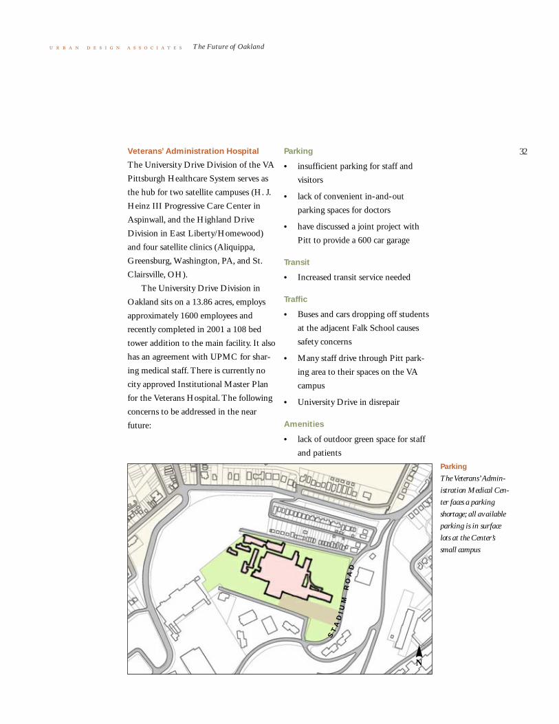
Veterans’ Administration Hospital
The University Drive Division of the VA
Pittsburgh Healthcare System serves as
the hub for two satellite campuses (H. J.
Heinz III Progressive Care Center in
Aspinwall, and the Highland Drive
Division in East Liberty/Homewood)
and four satellite clinics (Aliquippa,
Greensburg, Washington, PA, and St.
Clairsville, OH).
The University Drive Division in
Oakland sits on a 13.86 acres, employs
approximately 1600 employees and
recently completed in 2001 a 108 bed
tower addition to the main facility. It also
has an agreement with UPMC for shar-
ing medical staff. There is currently no
city approved Institutional Master Plan
for the Veterans Hospital. The following
concerns to be addressed in the near
future:
Parking
The Veterans’ Admin-
istration Medical Cen-
ter faces a parking
shortage; all available
parking is in surface
lots at the Center’s
small campus
N
ST
AD
IU
MR
OA
D
Parking
• insufficient parking for staff and
visitors
• lack of convenient in-and-out
parking spaces for doctors
• have discussed a joint project with
Pitt to provide a 600 car garage
Transit
• Increased transit service needed
Traffic
• Buses and cars dropping off students
at the adjacent Falk School causes
safety concerns
• Many staff drive through Pitt park-
ing area to their spaces on the VA
campus
• University Drive in disrepair
Amenities
• lack of outdoor green space for staff
and patients

33
The Future of Oakland
iii Other Master Plans andStudies
in addition to the institutional master plans, there are
other relevant plans and studies which were reviewed. These
plans are summarized on the following pages:
• Schenley Plaza
• Pittsburgh Regional Parks Master Plan
• Forbes Avenue Streetscape
• Western Gateway Portal
• Hazelwood/Junction Hollow

34
The Future of Oakland
Schenley Plaza
During the Fall of 2000, the Oakland
Task Force (OTF) sponsored a planning
process, the Oakland Civic District
Loop, in order to develop a shared vision
for improving Schenley Plaza and its
environs. The OTF sees an unprece-
dented opportunity for a new public
space in Oakland. Schenley Plaza will
become a strategic link between the Uni-
versity of Pittsburgh and Carnegie Mel-
lon University as well as a town square
for Oakland that will be a popular spot
for a revitalized Oakland “scene.” The
Oakland Civic District Loop process
established a consensus vision to replace
the existing parking lot with a new pub-
lic open space. In doing so, the OTF
hopes to restore to Oakland the grand
entrance to Schenley Park and create a
great open space amenity to increase the
quality of life for everyone in Oakland.
The OTF has been working to bring
this vision into reality while addressing
the issues identified by the Oakland
stakeholders. In March 2002, OTF
Schenley Plaza
retained the services of Daniel Bieder-
man, President of Bryant Park Restora-
tion Corporation and noted parks
programming expert, to develop recom-
mendations for the Schenley Plaza proj-
ect including project design concepts,
programming, maintenance, and finan-
cial feasibility. The study was completed
in the Fall of 2002.
The Oakland Task Force and the
Pittsburgh Parks Conservancy will facili-
tate a competitive selection process to
hire a design professional to conduct a
schematic design. This, in addition to
fun rasing efforts, will move the project
forward.

35
The Future of Oakland
The major programming and devel-
opment principles are as follows:
1 The new Schenley Plaza will be a
world-class facility to draw visitors.
2 The following amenities will enhance
the visitors experience: eating and
drinking kiosks, public art, historical
interpretive exhibits, chess boards,
moveable chairs, etc.
3 The role of the automobile will be
reduced. On-street parking will be
incorporated around the edges of the
park.
4 The history of the site will be
celebrated.
5 The abutting cultural and educa-
tional institutions will be encouraged
to become involved in the program-
ming of the space.
6 There will be wonderful landscaping,
flowers, and lighting.
7 There will be two well-maintained
public restrooms.
8 There will be mass transit amenities.

36
The Future of Oakland
Pittsburgh Regional Parks
Master Plan
The City of Pittsburgh and the Pitts-
burgh Parks Conservancy commissioned
a study in 2001 of the four major parks
in the city (Schenley, Frick, Highland,
and Riverview). The recommendations
for Schenley Park which are relevant to
the Oakland plan include:
• Redevelop Schenley Plaza as a signa-
ture entry into Schenley Park: create
usable public spaces, possibly a per-
formance amphitheater and shell,
improve lighting, provide places for
public art, celebrate the remnant of
Schenley Park
COURTESY: PITTSBURGH PARKS CONSERVANCY
N
Forbes Field, and reestablish the axial
relationship between the Mary
Schenley Fountain and the Cathedral
of Learning
• Link cultural and educational pro-
grammatic elements including:
Phipps Conservatory, Carnegie
Museums of Pittsburgh, and
Carnegie Library
• Incorporate traffic calming of Schen-
ley Drive as it leaves Schenley Plaza
• Emphasize pedestrian connections
from Oakland to Schenley Park

37
The Future of Oakland
Forbes Avenue Streetscape
The Oakland Business Improvement
District (OBID) commissioned a Forbes
Avenue streetscape study in 2001.
Establishing a consistent character
for Forbes Avenue is a major component
in producing an improved image for the
Oakland Business District. Maintaining
a consistent character should not pre-
clude variety throughout the various dis-
tricts in Oakland.
N
Forbes Avenue
Forbes Avenue includes
not only the central
retail area but also a
major portal from the
west and institutional
areas at Magee Hospi-
tal, Cathedral of
Learning, Carnegie
Museum, and
Carnegie Mellon Uni-
versity.
The project implementation area
occurs along the entire length of the
avenue from the Western Portal at the
Boulevard of the Allies to the eastern
edge of CMU at Margaret Morrison
Street. Four districts have been identi-
fied: Green Entrance, Urban Room,
Civic District Room, and CMU.
The July 2001 study is currently
undergoing substantial revisions. The
revised report is in final draft form and
will be finalized in the fall of 2002.
38
The Future of Oakland
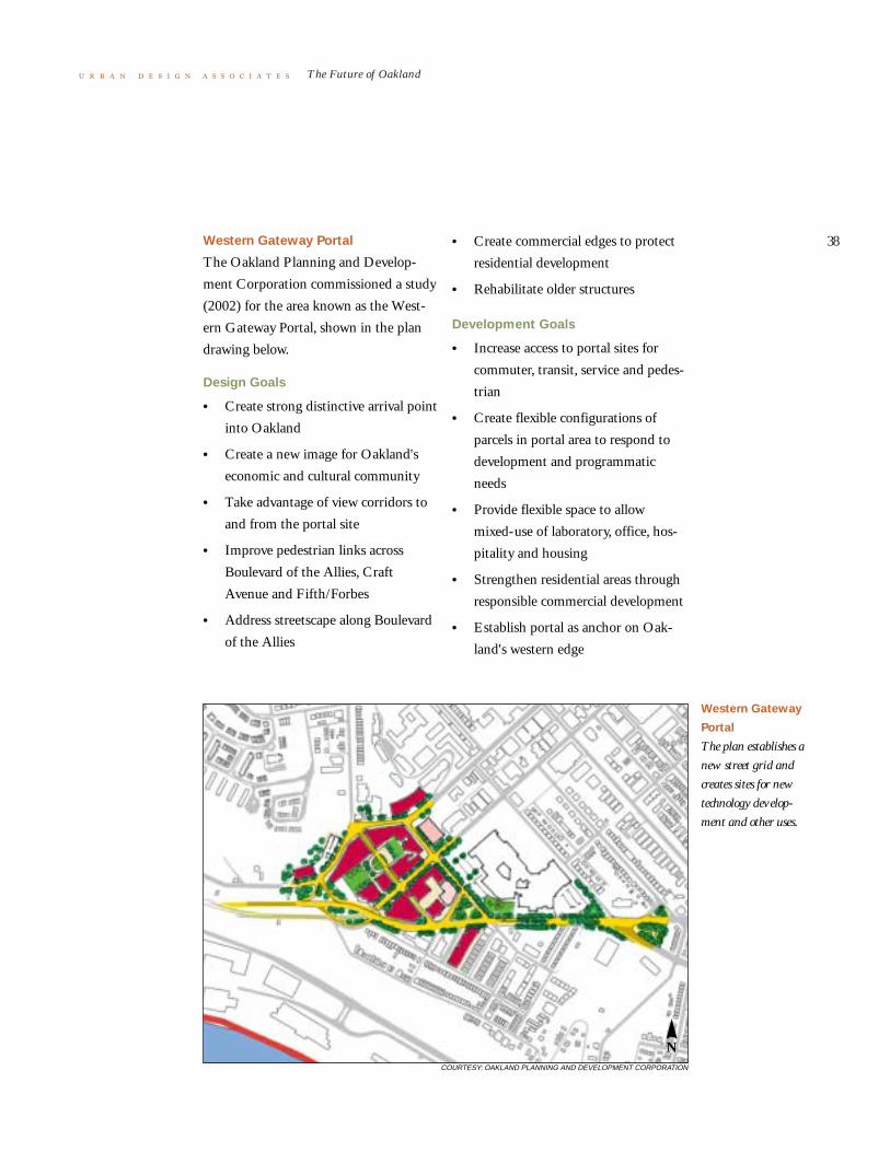
Western Gateway Portal
The Oakland Planning and Develop-
ment Corporation commissioned a study
(2002) for the area known as the West-
ern Gateway Portal, shown in the plan
drawing below.
Design Goals
• Create strong distinctive arrival point
into Oakland
• Create a new image for Oakland's
economic and cultural community
• Take advantage of view corridors to
and from the portal site
• Improve pedestrian links across
Boulevard of the Allies, Craft
Avenue and Fifth/Forbes
• Address streetscape along Boulevard
of the Allies
N
Western Gateway
Portal
The plan establishes a
new street grid and
creates sites for new
technology develop-
ment and other uses.
COURTESY: OAKLAND PLANNING AND DEVELOPMENT CORPORATION
• Create commercial edges to protect
residential development
• Rehabilitate older structures
Development Goals
• Increase access to portal sites for
commuter, transit, service and pedes-
trian
• Create flexible configurations of
parcels in portal area to respond to
development and programmatic
needs
• Provide flexible space to allow
mixed-use of laboratory, office, hos-
pitality and housing
• Strengthen residential areas through
responsible commercial development
• Establish portal as anchor on Oak-
land's western edge

39
The Future of Oakland
• Provide parking for new develop-
ment
• Possible development of intermodal
site
• Integrate transportation planning
into development alternatives
• Design buildings that respond to
location, program and context

40
The Future of Oakland
Hazelwood/Junction Hollow
The City of Pittsburgh commissioned a
study (2001) for a Master Development
Plan in Hazelwood and Junction Hol-
low, which involved community work-
shops with Hazelwood and Oakland
residents. Implications of the proposed
Mon-Fayette following the redevelop-
ment of the LTV site were studied, and a
preferred alternative was selected.
Cornerstones of the preferred sce-
nario
• LRT Transit connection between
Oakland and Hazelwood through
Junction Hollow, incorporating bicy-
cle and pedestrian access
• Renovating existing Hazelwood
housing
N
Hazelwood Plan
COURTESY: CITY OF PITTSBURGH DEPARTMENT OF CITY PLANNING
• Revitalizing commercial nodes along
Second Avenue
• Marinas
• Trails and open space along river
• High-tech office park development
• Mixed-use development specifically
below Hazelwood Avenue
Transportation
• The underpass at Second Avenue
and Greenfield Avenue is a critical
component in making the connection
between Oakland and Hazelwood:
provides potential portal entrance
into a new development on the LTV
site

41
The Future of Oakland
• Junction Hollow could accept a tran-
sit connection between Oakland and
the LTV site: transportation should
be one that is sensitive to the land-
scape, non-polluting, and not an
automobile roadway
• Mon-Fayette Tollway: seen as detri-
mental to the development of the
preferred scheme, the site becomes
one for transportation infrastructure
rather than new information-based
development, and an alternative
alignment was explored in order to
preserve homes and businesses
Mixed-Use Development
• Creation of a regional mixed-use
development that would allow for
light industry, recreation, open space,
research and development as well as
residential
• Create a sub-area that would be a
neighborhood scale mixed-use devel-
opment that would accommodate
smaller industry, housing and retail
footprints and better serve the imme-
diate needs of the adjacent neighbor-
hood
• Marina development that would
include: marinas, water taxi and
riverfront park

42
The Future of Oakland
iv Concurrences,Conflicts, and Gaps
a central task of The Future of Oakland was to determine if
there were conflicts between the institutional master plans and
the Oakland neighborhood. The news is good. There are far
more concurrences than conflicts because Oakland is fortunate
to have three important and interrelated planning mechanisms:
• consensus plans (the 1979 Oakland Plan and the 1998
Oakland Improvement Strategy)
• the Oakland Task Force
• the Institutional Master Plan Process
Although many planning studies have been completed for
Oakland, two stand out as particularly significant: The 1979
Oakland Plan, known as “The Citizen’s Plan,” because of the
extensive two year public planning process, established clear
planning boundaries for residential, institutional, and commer-
cial use; and the 1998 Oakland Improvement Strategy, a very
recent collaborative effort of Oakland stakeholders, which
resulted in an “action agenda” for zoning revisions, code
enforcement, traffic and streetscape improvements, and other
studies and projects.
The Oakland Task Force, formed in the early 1980’s by
Mayor Richard Caliguiri as an outgrowth of the 1979 Oakland
Plan, is in effect the “United Nations” of Oakland. It includes
institutions, government agencies, and the community. Meet-
ings are held on a regular basis to review, comment on, and
advocate planning and development issues, plans, and projects.
The Institutional Master Plan Process, mandated by the
City of Pittsburgh Zoning Ordinance, requires institutions to
prepare a master plan showing community impact for any
expansion project exceeding 25,000 square feet.
Nevertheless, there are a few conflicts and gaps, in addition
to the concurrences. Below are summarized:
• Concurrences
• Conflicts
• Gaps

43
The Future of Oakland
Concurrences
There is general consensus by the stake-
holders for a number of major projects
such as, revitalization of Central Oak-
land housing, increased on campus hous-
ing; improved Forbes Avenue business
district, enhanced public transportation
combined with parking management,
intercept parking, and shuttles, a redesign
of Schenley Plaza as vibrant public
square, and the rebuilding of the
Forbes/Allies bridge and ramps; and
improved gateways to Oakland.
Because the institutional master
plans and projects go through the Oak-
land Task Force review and the official
approval of the City of Pittsburgh Plan-
ning Commission and City Council, the
plans are well coordinated internally and
externally with the community and with
other institutional plans.
Conflicts
Some proposed projects which affect the
future of Oakland and which have not
achieved consensus within the Oakland
community include the closing or modi-
fication of Bigelow Boulevard between
Forbes Avenue and Fifth Avenue as pro-
posed by the University of Pittsburgh,
Forbes/Fifth one way conversion to two
Oakland Master
Plans
A number of plans are
in place or under
development in the
Oakland study area.

44
The Future of Oakland
way, location of Light Rail Transit, the
continuing development of Junction
Hollow for commercial uses as proposed
by the Panther Hollow Development
Corporation, the narrowing of Forbes
Avenue from the Forbes Avenue/Junc-
tion Hollow Bridge to Margaret Morri-
son Street as proposed by Carnegie
Mellon University, road or transit links
from Second Avenue through Junction
Hollow to Oakland, the construction of
the Mon-Fayette Tollway and its ramps,
replacement of Schenley Plaza surface
parking, and the addition of bike lanes
on arterial streets.
Gaps
There are both physical and management
gaps in the planning for Oakland.
The physical gaps include areas of Oak-
land for which plans do not exist or
where no group has taken ownership,
including the Syria Mosque (site con-
trolled by UPMC), North Oakland
(including Centre/Craig and the Mel-
wood Avenue area), Junction Hollow, the
transition area between Oakland and
Soho, the transition area between Oak-
land and the Hill District, commercial
properties on the south side of the
Boulevard of the Allies from Craft
Avenue to Bates Street, and the lack of a
neighborhood elementary school.
The management gaps include:
inability to engage absentee residential
and commercial landlords in the revital-
ization of Central Oakland and the
Forbes Avenue commercial district; and
lack of involvement of the Pittsburgh
Public Schools in neighborhood
revitalization.

45
The Future of Oakland DRAFT
v Areas of Opportunity the 1979 oakland plan identified fourteen Areas of Oppor-
tunity with suggested uses. Some of these areas have been
developed as recommended, such as the Carnegie Mellon Soft-
ware Engineering Institute on Fifth Avenue. Others, such as
the Western Portal, remain unfulfilled. For reference, the UDA
X- Ray drawing shown below illustrates in black all new con-
struction in Oakland since 1979.
The continuing development of Oakland, the shift of the
regional economy from traditional Pittsburgh industries to
knowledge industries, and the desire to capitalize on the
research resources and entrepreneurial talent in Oakland lead
to a different set of opportunity areas in 2002 shown in the
illustration on the next page.
Areas of Opportunity, as defined in this The Future of Oak-
land report, are those areas where new development can take
place, in some cases with new or adapted buildings for technol-
ogy based companies, but in other cases with new retail ameni-
ties, such as a university inn/conference center, cinemas, shops
and restaurants, while in other cases with new mixed income
housing, or with a mix of all three types of development.
There are eight areas of opportunity:
New Buildings
since 1979
Non-residential
buildings completed
since 1979 have, with
few exceptions, been
located either in the
institutional areas or in
one of the fourteen
Areas of Opportunity
identified in the 1979
Oakland Plan.
N

46
The Future of Oakland DRAFT
1 Western Gateway, including Blvd. of
the Allies commercial properties and
the transition area to Soho
2 Pittsburgh Technical Center, the
LTV site, and the transition into
Hazelwood
3 Junction Hollow
4 The ten block area defined by Fifth
and Forbes Avenues and Bellefield
and Craig Streets
5 North Oakland, including the Mel-
wood/Baum area and the
Centre/Craig area
6 The Forbes/Fifth retail district
7 Atwood Street
The boundaries of the neighborhood
fixed areas as illustrated in the 1979
Oakland Plan should remain unchanged.
Areas of Opportunity
1
2
3
4
5
6
7
N

47
The Future of Oakland
Transportation Analysis

48
The Future of Oakland
i Transportation Issues a number of working sessions were held with traffic, tran-
sit, and parking agencies, consultants, and institutional plan-
ners regarding transportation issues in Oakland. Below in this
section is a summary of the key findings of the issues which
arose in those discussions. The following section discusses:
Transportation Guiding Principles. Transportation Recom-
mendations are included in the last section of the report,
Recommended Projects.
A Perception of Traffic Congestion
Oakland as a major employment destination for the region
– a key element of the vision for Oakland – means a large, pre-
dictable flow of peak-hour traffic. While the regional road sys-
tem smoothly delivers this traffic to Oakland, a handful of
peak-hour traffic problems (“hot spots”) persist in Oakland:
Bates/Second Avenue/I-376 (where Oakland local streets join
the regional system), the continuation of Bates Street into
Oakland, the area around Schenley Plaza, and the Western
Gateway (Fifth, Forbes, and Craft).
These hot spots affect a substantial fraction of the daily
visitor population to Oakland, and perpetuate an image of
there being a consistent traffic problem in Oakland.
The perception of a traffic problem is also fostered by the
many demands on the two key east/west arterials, Forbes
Avenue and Fifth Avenue. In addition to serving as a route for
through traffic (i.e., with neither origin or destination in Oak-
land), these same two streets serve as an important part of the
distribution system for local destinations (hospitals and univer-
sities), serve as the address for valuable commercial fronting
properties, and serve the highly unusual function of a major,
high priority bus route system. While the traffic volumes are
not in themselves remarkable, the combinations of these activi-
ties has a large negative impact on traffic flow, and furthers the
perception that there is a congestion problem.
Finally, the blighted, unkempt appearance of almost all
public streets outside the well maintained interior spaces of the
institutions is a contributing factor to the sense that there is
continual congestion on the streets. Generally, streets with
ordinary levels of traffic, but with an unusually blighted

49
The Future of Oakland
appearance, are perceived as traffic prob-
lems, while conversely, streets with the
same level of congestion, but with a
superior urban environment, are seldom
regarded as traffic problems. Oakland
streets fall into the former category.
Fragmentation and Failure to Package
Destinations
In Oakland's vision, the remarkable indi-
vidual components – hospitals, universi-
ties, museums – cohere into a district
that carries its own identity, and conse-
quently derives great value (visitation,
attracting idea industries) from this iden-
tity.
Almost every facet of transportation
now works against this vision of an over-
arching identity for Oakland. The visi-
tors view (by any mode of arrival) upon
entering Oakland is that of blighted
gateways and roads, apparently given
over to moving traffic as though nothing
else matters. There is little to announce
the specialness of Oakland to the enter-
ing visitor, and even less to address ques-
tions likely to be dominating the visitors'
attention at this point (for example,
where to turn to reach their destination,
where to park, where to get off the bus,
etc.).
Once arrived in Oakland (success-
fully driving or exiting from a bus), the
visitor continues to find challenges to
district cohesion. Though compact, Oak-
land's destinations may be spaced beyond
walking distance for many people. Fur-
ther, the terrain may shorten almost
everyone's idea of a reasonable walking
distance. Yet there is no transparently
convenient shuttle. Excellent shuttle sys-
tems are run by Oakland's individual
entities. Unfortunately for the visitor,
these services appear to be privatized
(i.e., for somebody else), confusing, dis-
jointed from public transportation, and
mysterious. The sum of these services,
therefore, to the visitor, is less than their
parts.
The challenge to the district's cohe-
sion is keenly felt in that component of
travel common to almost all visitors'
experience – i.e., walking around in Oak-
land. The individual grounds within the
Oakland entities are, within themselves,
attractive, sometimes spectacular walking
environments, with a distinctive appeal.
The weather-protected, multi-level
indoor labyrinth of the UPMC Health
System main campus, the park jewel
around the Cathedral of Learning, the
“streets of learning” sloping down from
O'Hara Street and the grand museums
looming over major streets, are but some
of the examples. But there is not a good
connecting "mortar" of superior walking
environment holding the individual sites
together, and therefore no ensemble
effect of a series of individually good
sites combining into a remarkable district
that is more than the sum of its parts.
The spine streets – Forbes Avenue
and Fifth Avenue – the obvious candi-
dates for connective tissue, just can't
seem to make it as pedestrian magnets. A
series of small negatives, none fatal to a
good walking environment in itself, com-
50
The Future of Oakland
bine into a formidably negative package.
Narrow sidewalks, sidewalk pavement
condition, shabby street furniture, bus
volumes, barricaded contra-flow bus
lane, visiting drivers roaming for parking,
buildings blanked out at street level for
institutional use, and the milling of riders
at bus stops, all add up to make the
Forbes-Fifth spine a separator, not a
joiner of the already-nice walking insti-
tutional areas in Oakland.
The ultimate in centrifugal pedes-
trian forces is centered at Schenley Plaza
and the attached block of Bigelow
Boulevard between the Cathedral of
Learning and the Pitt Student Union.
Here, the pedestrian “center of gravity” of
the surrounding superior walking envi-
ronments (museums, Cathedral, Schen-
ley Park) is a 238-space parking lot. The
theme of giving over central pedestrian
space to noxious road use continues
along the adjacent piece of Bigelow
Boulevard (between Forbes Avenue and
Fifth Avenue), where a 60-foot pave-
ment (five lanes in most cities and easily
six lanes in Pittsburgh) gashes through
the otherwise-green jewel of the lower
Pitt Campus.
Good, not a “Good Experience”
The vision of Oakland, as an attractor of
travel of downtown-like proportions,
mandates that public transit play a large
role. And it does. The existing volume of
transit ridership in the corridor (30,000-
35,000 riders on the combination of
Forbes Avenue and Fifth Avenue bus
routes) outranks any corridor in any of
the eighteen “new start” light rail cities
(i.e., cities building or committing fund-
ing to light rail transit since 1984). The
frequency of service, because of the
bundling together (onto Forbes/Fifth) of
a myriad of routes, is excellent, with
nearly waitless service (every 2-5 minutes
between Oakland and downtown Pitts-
burgh, and short headways (5 minutes –
10 minutes) to/from the neighborhoods
(Squirrel Hill, Shadyside) to the east.
Policy actions to support transit (for
example UPMC bus pass purchase, Pitt
and CMU transit pass programs) are
exemplary, and deserve more recognition
as national models.
However, the vision for Oakland calls
for more from public transit than it cur-
rently delivers. Since all transit service is
on arterial streets, the gateway shortcom-
ings degrade the transit riders as well as
visitors in automobiles. The blighted
appearance of the entry and the disquiet-
ing uncertainty regarding whether or not
the transit rider has reached Oakland,
run counter to the vision of Oakland as
an even more powerful branded magnet
for visitation. The important points
where transit riders become pedestrians
are nothing more than on-street bus
stops, a level of accommodation grossly
out of tune with the existing level of
transit service and ridership, and at odds
with the commendable support of transit
by employers and the universities. Once a
pedestrian, the transit rider encounters
the same negatives as any other pedes-
trian: a lack of continuity between the

51
The Future of Oakland
isolated institutional spaces of good
pedestrian qualities, leaving the transit
rider to negotiate a second-rate experi-
ence between transit ride (good service)
and destination (good walking environ-
ment).
The frequency of service and the
high volume of ridership of the existing
bus service, on one hand signs of success,
are on the other hand symptomatic that
the service is nearing the end of the line
of quality as bus-only service. The num-
ber of buses and the number of board-
ing/exiting passengers in Oakland
produces a particularly aggravating type
of transit service congestion, with buses
approaching a stop being detained by
other buses servicing passengers. The
definitive fix to this problem – off-street
stations with several parallel loading bays
– is problematical, possibly unworkable
in the elongated Forbes/Fifth corridor,
where several such stations, possibly on
two different streets, would be needed. A
less comprehensive fix – buses simply
overtaking stopped buses – is a partial
and problematical remedy, making
focused terminals almost unworkable,
and bringing bus traffic and bus lane-
changing maneuvers into yet another
lane of street traffic, on the already-
stressed lanes of Forbes Avenue and
Fifth Avenue.
Bus rapid transit, a “virtual subway”
for buses, an interesting idea for high-
volume bus corridors, is challenged by
some features unique to Oakland. Desti-
nations spread out linearly (requiring
multiple transit stops), the bundling of
many routes into a single street (preclud-
ing a first-in/first-out boarding by wait-
ing passengers) and the length of loading
platform needed are all issues that seri-
ously erode the feasibility of bus rapid
transit as what at first thought appears an
attractive solution to current problems
and a way to take bus service to the next
level.
The institutional sponsors of bus rid-
ership share the concern that the existing
bus service cannot be made dramatically
better. Routes to give direct (no transfer)
service to Oakland (as contrasted to
routes requiring a transfer in downtown
Pittsburgh) are a frequently cited need.
Accommodating bus traffic, an emi-
nently worthy goal in terms of total
access to Oakland, has intruded into
other travel qualities: contra-flow lane
needing barricading from pedestrian
crossing, removal of parking on one side
of streets, heavy bus traffic adjacent to
narrow sidewalks in a business district,
and so forth. Further expediting bus flow
(for example, through a virtual subway,
would lead to more of these “takings” of
other qualities in the corridor, and would
conflict with most facets of the Oakland
vision. It is obvious that the evolution to
a Light Rail System is the correct direc-
tion to take.

52
The Future of Oakland
A Perception of Nowhere to Park
To the arriving motorists, parking is the
most stress-prone phase of their trip. The
entry to Oakland and the driving on
interior Oakland streets, while not the
well-announced or aesthetically pleasing
experiences that they should be, are at
least a fairly certain undertaking to the
motorist. The landmarks (medical center,
Cathedral of Learning, etc.) are promi-
nent enough to reassure the motorists
that they are in the right general area.
However, the motorists are not
assured that they will find parking. The
visible parking – on-street and, in Schen-
ley Plaza – is full most of the day. “Cruis-
ing” for spaces, the normal practice for
finding an available space in a tight sup-
ply, is difficult because of one-way streets
and traffic congestion.
Although a large amount of off-
street parking is located within Oakland,
it is difficult for the arriving motorist to
find it. Within some individual precincts
(for example, UPMC), the location of
off-street parking is well marked to the
arriving motorist. However, this superior
way-finding ends abruptly at the edge of
precincts, and the incoming motorists on
the major arterial routes (Forbes Avenue,
Fifth Avenue, Bates Street) have no idea
of where the available parking is located.
There is no real-time information
that redirects motorists from sold-out
parking facilities to other, nearby facili-
ties with space available. Rather than
being directed routinely to available
parking, the motorists who are turned
away at a full facility are simply on their
own.
The great diversity of destinations
within Oakland (hospitals, universities,
museums) leads, in turn, to a wide varia-
tion in the daily profile of occupancy in
parking facilities. Consequently, substan-
tial amounts of parking are always avail-
able in the area, but in places and on
schedules unknown to the visitor. Better
information – both permanent way-find-
ing and real-time availability/redirection
advice – is the obvious answer.
The degraded walking environment
has much to do with the perception of
not enough parking. The fragmented
walking environment of Oakland, char-
acterized by nice environments within
the grounds of Oakland's individual enti-
ties separated by pedestrian no-man's
lands, further fuels the notion of not
enough parking. Believing (correctly)
that Oakland does not have a continu-
ously vibrant walking atmosphere,
motorists seek to park on the premises of
their final destination. The idea of park-
ing in available spaces at one site, and
walking to a final destination on another
site is unthinkable to most visitors to
Oakland. Yet, this ability to fully use all
the parking resource in a district by
exploiting a superior walking atmosphere
is commonplace in downtowns, cam-
puses, the current generation of sports
stadiums and so forth.
The spectrum of parking “products”
in Oakland has a notable gap. Most
downtowns and downtown-like concen-
53
The Future of Oakland
trations (of which Oakland is certainly
one) have evolved a fringe parking sup-
ply, characterized by relatively low-cost
parking (compared to the interior of the
district), easy entry/exit to the regional
road system, and frequent, convenient
shuttles from fringe parking to district
center. This parking product obviously
has appeal to the daily visitor (employee,
student) who has a long duration of
parking stay, and no need for their vehi-
cle while in Oakland. Fringe parking well
served by shuttle also appeals to visitors,
who can then arrive in Oakland upon
reaching the fringe parking destination.
Further mobility to the final destination
in Oakland is assured through the high-
quality shuttle service, an essential part
of the shuttle parking scheme.
Neighborhoods Degraded by
Non-residential Traffic
Large travel destinations of any sort
pose transportation-related challenges to
their residential neighbors, and Oakland
furnishes a catalog of these challenges.
The institutions' employees and students
learn the local street system in detail, and
find cut-through routes on residential
streets. Some streets have a lot size and
building type that can stand up to the
presence of collector-level street traffic,
and hold their value as durable residen-
tial areas. Unfortunately, most streets are
not so equipped, and the volume or
behavior of cut-through traffic hastens
the conversion of owner-occupied single
family homes to student apartments.
The most serious transportation
challenges that institutions raise, how-
ever, are not the vehicular traffic impacts,
but the degradation of the walking envi-
ronment. Thus, paradoxically, as more
pedestrians are deposited on the Oakland
streets, and as a longer walk becomes
necessary for a number of reasons (transit
access, parking access), the very source of
this additional pedestrian travel con-
tributes to degrading the pedestrian
travel experience. Blank building walls
fronting streets, loss of pedestrian scale,
walls and berms, fences, and surface
parking lots were some of the conse-
quences of institutional expansion that
erode the walking environment in adja-
cent neighborhoods. Today, however, the
institutions are much more aware of the
pedestrian experience and the role design
plays in those experiences.

54
The Future of Oakland
ii Transportation GuidingPrinciples
from the issues discussed above, from the Department of
City Planning report, “Oakland Mid-Range Transportation
Alternative Study,”and from extensive working sessions with
the key traffic engineers from the City of Pittsburgh,
PennDOT, Port Authority of Allegheny County, Parking
Authority of the City of Pittsburgh, and institutions in Oak-
land, six guiding principles for transportation have emerged:
1 Fix traffic hot spots. A large amount of traffic aggrava-
tion and perception of traffic problems stems from a few
fairly tractable hot spot problems (particularly, Bates Street
interchange with the Parkway East, Bates Street at the
Blvd. of the Allies, Central Oakland streets, and the West
Gateway, including Craft Avenue, Fifth Avenue, and
Forbes Avenue). Some of the traffic hot spots are also
pedestrian cold spots or blighted areas, such as Bates and
the Blvd. of the Allies.
2 Intercept more vehicular traffic at Oakland’s perimeter.
This not only reduces internal traffic, but also helps park-
ing and supports internal transit.
3 Gain more use of the existing parking supply. Much of
the perception of a parking problem is due to lack of infor-
mation, not lack of spaces.
4 Commit to developing full light rail transit. Oakland is
at the end of the line with what can be done with buses
because of the high volume of daily riders (35,000). For
this very reason, Oakland meets the reasonable thresholds
for investment in LRT.
5 Develop internal transit shuttles. These are key to serv-
ing satellite job concentrations, intercept parking and resi-
dent mobility.
6 Fix pedestrian “cold spots” that now isolate the pods of
good pedestrian environment, such as stretches of Fifth
Avenue near UPMC and of Forbes Avenue near Magee
Hospital.

55
The Future of Oakland
iii Transportation Alternatives
Priority/Near Term
1 Complete the Forbes/Blvd. of Allies bridge replacement
project.
2 Develop a traffic and parking plan for Schenley Plaza and
the Civic Loop in conjunction with the reprogramming
and design of Schenley Plaza as a town square. (See dia-
gram at the end of this section).
3 Conduct an integrated “Hot Spots” transportation study
with design recommendations for lower Bates/Second/I-
376 interchange; Bates/Blvd of Allies/Halket; West Gate-
way, including Craft Avenue; Forbes/Fifth one way/two
way options; and Bigelow Blvd (between Forbes and
Fifth). (See lower Bates and Bates/Allies diagrams at the
end of this section).
4 Develop a recommendation regarding on/off ramp loca-
tions at Second Avenue and Bates for the proposed Mon-
Fayette Tollway.
5 Actively participate in the East Corridor Transit study
being prepared for the Port Authority of Allegheny
County, particularly to advocate for Light Rail Transit
between Oakland and Downtown and to express prefer-
ences for Light Rail Transit alignments and station loca-
tions. (See Bus and Light Rail Recommendations at the
end of this section).
6 Conduct shuttle bus demonstration trials for internal Oak-
land shuttles between the institutions and neighborhoods
in Oakland, and for an express shuttle between Oakland
and Downtown.
7 Conduct a planning study for the construction of com-
muter intercept fringe parking facilities for the West Portal,
North Oakland, and the LTV site and the Pittsburgh
Technology Center.

56
The Future of Oakland
Longer Term
1 Design and develop a new prototype
bus station (elongated to accommo-
date both doors of an articulated bus)
that could be a precursor to higher
levels of transit technology such as
Bus Rapid Transit or Light Rail
Transit. The station would be attrac-
tive and weather protected, but
would also allow for off-board fare
collection and video and/or digital
readouts indicating the next buses
arriving. Vending machines, bike
racks, and security cameras could also
be incorporated into the design.
2 Undertake an analysis of public
awareness of transit service and
develop a marketing and promotion
strategy to increase the general com-
prehension and usage of the service,
with non-transit riders as focused
targets of the campaign.
3 Expand existing carpool/vanpool
programs.
4 Develop an Oakland wide parking
management program, including
intercept parking, valet parking,
meter program expansion, parking
cap on Central Oakland spaces, and
an electronic signage system which
could direct motorists from full
garages and lots to garages or lots
with available spaces.
5 Create bike lanes on appropriate
streets which will serve commuters,
and which will link to the ever grow-
ing city-wide system of bike routes
and trails, including connecting to or
the new trail head proposed for the
redesigned Schenley Plaza.
6 Construct a bike station within or
near Schenley Plaza
The following pages contain diagrams,
recommendations, and alternatives for:
1 Schenley Plaza/Civic Loop
2 Lower Bates (Parkway East/Second
Avenue)
3 Bates/Boulevard of the Allies (three
options)
4 Bus system
5 Light Rail Transit

57
The Future of Oakland
Schenley Plaza/Civic Loop
Recommendations
The redesign of Schenley Plaza to a pub-
lic square is a consensus project of the
Oakland Task Force. A process is under-
way to develop a program, select a design
team, and proceed with a major improve-
ment project. An important aspect of
that redesign will be to accommodate the
traffic that now currently drives through
and around Schenley Plaza, currently a
surface parking lot operated by the Pitts-
burgh Public Parking Authority.
Working meetings with the Schenley
Plaza Steering Committee, a committee
of the OTF, and with programming con-
sultants, have led to a recommendation
for traffic improvements that will be sup-
portive and complementary to any future
design for the public square. The main
features, as shown on the following page,
involve making Schenley Drive two-way
to meet Roberto Clemente Drive, and
making Forbes Avenue two-way from
Bellefield Street to Bigelow Boulevard
(or perhaps to Bouquet Street), which
eliminates the internal service road paral-
lel to Forbes Avenue. Diagonal metered
parking is installed in front of the
Carnegie Library and Hillman Library
for library visitors.
Schenley Plaza Traffic Improvement
Elements
By restoring two-way traffic flow to
Forbes Avenue westward to Bigelow
Boulevard (or perhaps to Bouquet
Street), the need for the southbound
roadway within Schenley Plaza would be
eliminated. If Roberto Clemente Drive
was to provide two-way traffic flow, traf-
fic from Schenley Plaza can reach most
of Oakland without going around the
plaza or using Bigelow Boulevard. The
unneeded pavement from the existing
overly wide and misshapen Roberto
Clemente Drive should be reclaimed for
park use. One-way, one-lane operation
on Pennant Place and one-way, two-lane
flow on the segment of Schenley Drive
adjacent to the plaza should be retained.
The alignment of Bigelow/Pennant
intersection should be examined to see if
southbound weaving movements can be
eliminated. One lane in each direction on
Roberto Clemente Drive adjacent to the
plaza should be provided.
On Pennant Place, move the diago-
nal parking to the Carnegie Library side
(36 spaces) and move the parallel parking
(18 spaces) to the plaza side. Provide a
crosswalk, joined by bulb-outs, between
the Carnegie Library and the plaza. On
Schenley Drive adjacent to the plaza,
provide diagonal parking (31 spaces) on
the Carnegie Museum side of Schenley
Drive.

58
The Future of Oakland
Advantages:
Substantial amount of space con-
verted from unneeded road use to
much-needed park space.
Roberto Clemente Drive functions as
reliever to Forbes Avenue, Fifth
Avenue and Bigelow Boulevard.
Compatible with downsizing of
Bigelow Boulevard to a “festival
street," with a narrow cartway, brick
paving, and no curbs.
Some new parking to partially
replace that removed from the plaza.
Schenley Plaza
Fo
rbe
s A
ve
nu
e
Bigelow
Challenges
Two-way traffic on Forbes Avenue
slower than one-way traffic.
Roberto Clemente/Schenley Drive
intersection busier than at present.
Some green area converted to park-
ing along Schenley Drive adjacent to
plaza.
Hillman
Library
Stephen
Collins Foster
Memorial
Carnegie Library
Frick
Fine Arts
N

59
The Future of Oakland
Lower Bates
(Parkway East/Second Avenue)
Lower Bates Street, where it intersects
with the Parkway East and Second
Avenue, is confusing, congested, con-
stricted, dangerous, and unsightly.
The narrow width of the former rail-
road bridge, now used for the bike trail,
limits the length of the left-turn lane
from Bates Street southbound into Sec-
ond Avenue eastbound to only three or
four vehicles. This is grossly inadequate
for the large demand for this movement
during the p.m. peak hour. Consequently,
the single available southbound lane
north of the bike trail bridge is heavily
congested, carrying all of the southbound
Bates Street traffic (left turn, through
and right turn). During the p.m. peak
hour, this queue extends up Bates past
the intersection with the eastbound on-
ramp to the Parkway East. Thus, the
large movement from Bates Street to the
Parkway is denied access, further extend-
ing the backup northward on Bates
Street toward the Boulevard of the
Allies. A further consequence of the con-
gestion is the inability for westbound
motorists exiting the Parkway destined
for Hazelwood or the South Side to
enter Bates Street southbound, since the
ramp junction with Bates Street is typi-
cally blocked by motorists on Bates
Street unwilling to yield right-of-way to
the entering vehicles.
This situation is a traffic “hot spot”
warranting immediate attention. Further,
the hot spot, if not redesigned, will
obstruct two future desirable components
of traffic planned for Bates Street: (1)
shuttle traffic (both transit vehicles and
private automobiles) between the institu-
tional employment core in Oakland and
the employment satellites at the Pitts-
burgh Technology Center, LTV/Hazel-
wood, and South Side, and (2) access to a
potential fringe intercept parking loca-
tion on Second Avenue at the Pittsburgh
Technology Center or a small portion of
the LTV site.
Lower Bates Street Improvement Ele-
ments
• Replace existing bikeway bridge (old
railroad bridge over Bates Street)
with a bikeway bridge that can span
up to five lanes of traffic plus side-
walks (60-70 feet).
• Lengthen the left-turn lane on Bates
Street southbound to Second Avenue
eastbound by some 300 feet, extend-
ing it to a point near the current
Bates Street/Parkway off-ramp junc-
tion. This yields two lanes south-
bound on Bates Street, and forms the
southern part of a continuous expan-
sion of Bates Street to two lanes
southbound, extending from Boule-
vard of the Allies to Second Avenue.
• Relocate the intersection of the Bates
Street/Parkway on-ramp northward
by some 100 feet, thereby: (1) pro-
viding more storage room for the
improved left-turn lane from Bates
Street southbound into Second
Avenue eastbound and (2) favoring,

60
The Future of Oakland
through intersection geometry, the
movement from Bates Street south-
bound into the Parkway on-ramp.
• Realign the I-376 Oakland exit ramp
to allow for the widening of Bates
Street to four lanes up to the Glen-
wood exit ramp and eventually to the
the Boulevard of the Allies.
• Improve access to the Eliza Furnace
Bike Trail.
• Separate bike traffic from Bates
Street vehicular traffic.
Lower Bates Street
N
Second Avenue
Bate
s S
treet

61
The Future of Oakland
Bates/Boulevard of the Allies
The Bates Street Intersection with the
Boulevard of the Allies has been studied
many times. In addition to the run down
buildings which are a dismal gateway to
Oakland, the traffic patterns are con-
gested and dangerous.
For motorists driving up Bates
Streets to Oakland from the Parkway
East or Second Avenue, the intersection
is a difficult decision point at the crest of
a vertical curve. Little advance informa-
tion about destinations or options is
available at the approach. There is a sin-
gle left turn lane into what should be
(but is not) the preferred route into Oak-
land. Instead, the view of the Cathedral
of Learning draws the unknowing
motorist across the intersection onto
Bates Street and into the dense Central
Oakland residential neighborhood,
where the streets are narrow with on
street parking. This confuses the motorist
at the same time it degrades the neigh-
borhood.
The Boulevard of the Allies is a fast
moving high volume arterial street which
dips down to meet Bates at that same
critical intersection, not only with Bates,
but also with Zulema and Halket Streets,
creating a large area of undefined pave-
ment and an isolated and rarely used
park surrounded by commuter congested
roads.
• Following are three options for
redesigning the Bates/Boulevard of
the Allies intersection:
• Option 1: McKee Place and Halket
Streets as a one-way pair
• Option 2: Bates Street cul de sac
• Option 3: Multiple turn opportuni-
ties
The resolution of this intersection is
critical. The OTF should convene a
workshop to examine the alternatives
and to recommend a preferred direction,
including the addition of a pedestrian
cycle in the traffic signals.
NOTE: A more detailed discussion of
Options 1 and 2 can be found in the
Bates Street/Boulevard of the Allies
Study.
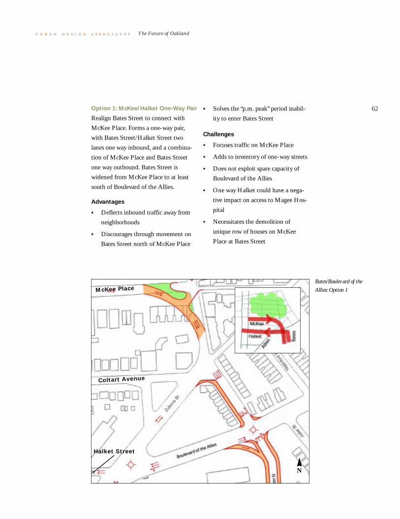
62
The Future of Oakland
Option 1: McKee/Halket One-Way Pair
Realign Bates Street to connect with
McKee Place. Forms a one-way pair,
with Bates Street/Halket Street two
lanes one way inbound, and a combina-
tion of McKee Place and Bates Street
one way outbound. Bates Street is
widened from McKee Place to at least
south of Boulevard of the Allies.
Advantages
• Deflects inbound traffic away from
neighborhoods
• Discourages through movement on
Bates Street north of McKee Place
• Solves the “p.m. peak” period inabil-
ity to enter Bates Street
Challenges
• Focuses traffic on McKee Place
• Adds to inventory of one-way streets
• Does not exploit spare capacity of
Boulevard of the Allies
• One way Halket could have a nega-
tive impact on access to Magee Hos-
pital
• Necessitates the demolition of
unique row of houses on McKee
Place at Bates Street
N
McKee Place
Coltart Avenue
Halket Street
Bates/Boulevard of the
Allies: Option 1

63
The Future of Oakland
•Option 2: Bates Street
In this option, Bates Street terminates at
a cul-de-sac just to the north of Boule-
vard of the Allies. All traffic between
Bates Street (south of Boulevard of the
Allies) and Oakland is therefore chan-
neled onto Boulevard of the Allies.
Halket Street and Craft Street are
changed to a one-way pair to deliver the
traffic from Boulevard of the Allies to
Oakland.
Advantages
• Provides a positive barrier against
cut-through traffic from Bates Street
into Oakland neighborhoods
• Takes full advantage of the capacity
of Boulevard of the Allies
• Distributes traffic between Boulevard
of the Allies and Oakland on appro-
priate streets (i.e., Halket Street and
Craft Street)
• Narrow streets at numerous points
Challenges
• Closes an important – even if only
local – street (closure is always a
problematical action)
• Redirects traffic that is legitimately
on Bates Street (i.e., not cut-through
traffic) onto other residential streets
• Unnecessarily large turning move-
ments at the Allies/Bates intersection
N
Coltart Avenue
Halket Street
Bates/Boulevard of the
Allies: Option 2

64
The Future of Oakland
Option 3: Multiple Turn Opportunities
In this option, incoming traffic has two
opportunities to turn left from Bates
Street: at Boulevard of the Allies and at a
reconfigured intersection on the north
border of the Allies/Bates/Zulema trian-
gle. The left turn inbound to Oakland is
expedited at both places, by (1) dual left
turn and signs at the Bates/Allies inter-
section and (2) the reconfiguration of the
Bates/Zulema intersection, so that the
“through” movement northbound into
Oakland is diverted westward on
Zulema, where it can then either join
Boulevard of the Allies westbound or in
a free right turn onto Halket Street west-
bound.
N
Coltart Avenue
Halket Street
McKee Place
Bates/Boulevard of the
Allies: Option 3

65
The Future of Oakland
Advantages
• Two opportunities to turn left into
Oakland, neither of which involve
penetrating the neighborhoods along
Bates Street
• Discourages the use of Bates Street
for through traffic, because of the
reconfiguration of the Bates/Zulema
intersection
• Permits “recovery” from an unin-
tended route choice (staying on Bates
Street through Boulevard of the
Allies)
Challenges
• Does more for inbound (a.m.) than
for outbound (p.m.) traffic
• Drivers will need to be educated to
the new left-turn opportunity.
• What is the impact on Coltart
Avenue?
• What is the impact of a right turn
onto Harket for pedestrians?

66
The Future of Oakland
Bus System
There are few options for improving the
bus system. The focusing of bus service
onto a single street (Forbes or Fifth) with
rapid transit-like characteristics (Bus
Rapid Transit, for example) including
fully reserved lanes and elongated stops
is disappointingly difficult to apply in
Oakland because of the number of
routes, the number of stops, narrow side-
walks, and the need for “off line” stations
which would consume more lanes.
Converting more lanes to transit use,
in the form of either with-flow or con-
tra-flow lanes on Forbes Avenue, for
example, provides a small increment of
transit service improvement that would
certainly be greatly outweighed by the
negative impact on traffic flow. An
underlying problem of the current bus
service – loading for the myriad of bus
routes – is not helped by more exclusive
lanes, and could even be hindered if
buses are no longer free to change lanes.
This leads inexorably to the conclu-
sion that the bus system is maxed-out
and a higher level of service is needed,
such as Light Rail Transit.
Light Rail Transit
This study did not allow for extensive
analysis of the potential for Light Rail
Transit. Fortunately a major investment
study is being done by the Port Author-
ity of Allegheny County (PAAC) for the
Eastern Corridor, the area from Down-
town to Oakland to the city neighbor-
hoods and suburban communities to the
east. Our recommendation is that the
Oakland Task Force become actively
engaged in the PAAC Eastern Corridor
Analysis and request that the following
alternatives be studied in detail:
1 LRT underground (under Fifth
Avenue) This will establish feasibil-
ity of an underground alignment.
2 Surface alignment on Forbes and
Fifth This split street alignment is
used successfully in downtown Port-
land and downtown Denver.
3 Surface alignment on Forbes in an
exclusive right-of-way on a double
track in a median This will test a
European-style “transit street” with
automobile traffic relegated to a
minor role. Fifth Avenue would
carry the bulk of both through and
destination traffic. This offers the
ultimate in urban design potential.
4 On surface on Fifth Avenue in
lanes shared with automobile
traffic While not the ideal transit or
urban design solution, this configura-
tion provides surface LRT service
with the least impact on traffic
capacity. Testing this alternative
helps to gauge the "price," in terms
of traffic flow, for going to other
options that are better for LRT and
urban design.

67
The Future of Oakland
Benchmarking Summary

68
The Future of Oakland
i Lessons from Benchmarking Trips
below are summary highlights of lessons learned for Oak-
land from the benchmarking trips to Cambridge, Austin, and
Philadelphia. One startling statistic is the size of endowments
of the universities we visited – Harvard ($18 billion); MIT ($6
billion); University of Texas ($6.9 billion); and University of
Pennsylvania ($4.3 billion) – when compared to those of the
University of Pittsburgh ($1.1 billion) and Carnegie Mellon
University ($750 million).
Cambridge
Institutions, such as Harvard and MIT, with international rep-
utations and “brands” are formidable attractors of talent,
grants, and investment. Cambridge, with its sophisticated and
diverse urban lifestyle and concentration of technology assets,
when combined with those of Boston across the Charles River,
is almost unrivaled for its pull on students, knowledge workers,
companies, and investors. Massachusetts Avenue (especially
Harvard Square and Central Square) is a prime example of the
kind of retail area commensurate with world class university
districts, which is welcoming of both creativity and diversity.

69
The Future of Oakland
Cambridge
N
a car free lifestyle compatible with world
class cities. Rigorous parking manage-
ment controls are then combined with
the ubiquitous transit system.
A supply of mixed income housing is
essential. This is a severe problem in
Cambridge, which has become a city of
the very rich and the very poor (in
assisted units). As a result, Harvard and
MIT are finding it difficult to retain mid
level faculty and staff. In addition, the
community is concerned about gentrifi-
cation.
Town/gown relations must be a con-
tinuing dialogue. Harvard and MIT both
had to learn this lesson the hard way, so
that even though they now engage in
proactive community outreach, there are
still criticisms of “Harvard is the devil”
and “MIT is buying up everything.” The
success of the Oakland Task Force stands
in clear contrast.
There is a track record of profitable
university driven private development of
technology buildings, but it is also appar-
ent that having a critical mass of such
activity is a necessary ingredient of suc-
cess. MIT, with 10% of its endowment
committed to real estate investments,
developed with Forest City Enterprises a
series of bio-technology buildings and
the Hotel@MIT. It is also clear that
technology companies want to be physi-
cally near the research professors, univer-
sity labs, and pool of students.
Cambridge has clusters of both bio-tech-
nology and information technology,
allowing for one growing sector to offset
the decline of the other. The City is able
to set and maintain very high standards
and design guidelines for development.
Easy to use and inexpensive fixed rail
transit is a quality of life enhancement in
Cambridge and Boston, which facilitates

70
The Future of Oakland
Austin
It is valuable to have an institution with
large financial assets and unrivaled politi-
cal clout – the University of Texas (UT).
On the other hand, UT is the only game
in town, within which reside nearly all
cultural and educational resources. Pitts-
burgh and Oakland on the other hand,
are rich by comparison in the number
and strength of both cultural and institu-
tional resources.
Having a clear and universally sup-
ported regional economic plan with a
long range view can pay huge dividends.
Austin and UT, starting in 1958, devised
a strategy to diversify the regional econ-
omy beyond State government and the
university into light manufacturing.This
eventually evolved into a strategy for
attracting computer, software, and semi-
conductor companies. Commitment to
creating twenty-five new UT professor-
ships and several new engineering
departments in 1983 became the decisive
move to win the national competition for
the federal research institute known as
the Microelectronics and Computer
Corporation (MCC). A similar push led
to the attraction of Sematech, the
research consortium of U. S. semi-con-
ductor manufacturers. Major facilities
include IBM, Texas Instruments, Intel,
AMD, Motorola, and Dell (which
started in a UT dorm room).
Central Austin
N
71
The Future of Oakland
Unquestionably, having a confident,
“can do,” attitude such as prevails in
Austin, supports risk taking and entre-
preneurship. Failure is seen as only a step
to success. This attitude, when combined
with the laid back (but not lazy) lifestyle
of Austin creates a positive regional per-
sonality which is manifestly evident.
Entertainment and outdoor recre-
ation are hallmarks of the Austin
lifestyle. Over 100 live music venues,
many fine regional restaurants, and an
almost spiritual connection to nature
(epitomized by their reverence for Barton
Springs) reinforce the uniqueness of the
place. There is a deliberate Austin ethic
to support local merchants and local
bands. You become an Austinite over
night when you move there. It was inter-
esting to note that very little of the
vaunted Austin nightlife is on the
“Drag,” the rather unremarkable main
street next to the UT campus.
On the negative side, Austin's eco-
nomic dependence on computer, soft-
ware, and semi-conductor industries
make it very susceptible to fluctuations in
the tech market. As a result, the 2000
Nasdaq crash hit Austin particularly
hard. Austin’s strategy to diversify into
bio-tech is hampered by the lack of a
teaching hospital or discernable bio-tech
industry. The university only houses
5,000 of its 51,000 students on campus,
putting tremendous pressure on the adja-
cent neighborhoods. It is an auto-
dependent community with only a 4.9%
transit penetration. Despite Austin’s rep-
utation for diversity (at least in lifestyle),
the city is racially segregated and minor-
ity enrollment at the university is quite
low.

72
The Future of Oakland
Philadelphia
The lesson from Philadelphia is that one
institution can make a difference if moti-
vated and armed with sufficient
resources. The University of Pennsylva-
nia (Penn) has been the driving force
behind the West Philadelphia Initiative
(Initiative), a five part community revi-
talization program funded primarily by
Penn (clean and safe; housing; education;
retail; and development).
The impetus for Penn’s aggressive
program was the murder of a student in
an off-campus robbery six years ago fol-
lowed shortly by the severe injury of
another student in a robbery. Penn saw
enrollments drop, acceptances drop, and
much parental concern. Penn had two
choices: wall themselves off even more
than they were; or reach out to the
neighborhood. They chose the latter,
which led to creation of a service district
(the University City District), which
operates like a business improvement
district, but is funded solely by the insti-
tutions (Penn puts up $2 million annu-
ally of the $5.2 million budget).
As part of the initiative, Penn also
financed and built a new neighborhood
elementary school for the Philadelphia
public schools as a turnkey project to
expedite its delivery. In addition, Penn
has committed to pay a $1000 subsidy
per student annually for ten years to sup-
port the operation of the school. The
housing component was in two parts: a
home ownership grant program
($15,000) to staff and faculty who chose
to live in the target area (300 Penn fami-
lies have participated); and the purchase,
upgrading, and management of 1000
rental units in the neighborhood.
Retail development has been signifi-
cant. The center piece is Sanson Com-
mons, a $90 million university
development near t he heart of the cam-
pus which includes the 250 room Inn at
Penn, the University Bookstore (man-
Philadelphia
N

73
The Future of Oakland
aged by Barnes and Noble), an upscale
restaurant, coffee shop, and stores such as
Eastern Mountain Sports, Urban Outfit-
ters and The Gap. Penn is remodeling
main street buildings on 40th Street for
student-oriented retail. Adjacent to that
they have developed Hamilton Square,
which includes a Fresh Grocer, and a
multi-screen cinema.
Penn has been less successful in
developing or attracting technology busi-
nesses. This is partly because the style of
Penn and its hospitals is one of research
for science-sake seemingly at the expense
of developing a tech transfer mentality,
such as exists at MIT.
One criticism heard from community
activists and students, is that Penn acts
paternalistically and does what Penn
thinks best for the neighborhood. Even
though most of those efforts have been
favorable in outcome to the neighbor-
hood, there is still a lingering feeling of
“what Penn wants, Penn gets.” A term
used was the “McPenntrification” of
West Philadelphia.
Drexel, adjacent to Penn, has not
participated very much in the Initiative,
other than their contribution to the serv-
ice district. Drexel has just doubled their
enrollment and is seeking to double it
again. This has led to some town/gown
friction in the adjacent Powelton neigh-
borhood.
As in Austin, student nightlife is not
on or near the campuses, but is a subway
ride away in Old City or South Street in
the center of Philadelphia, or a short
Amtrak ride away in the center of New
York City. Minority students, foreign
students, and gays feel accepted at Penn,
but less so at Drexel.

74
The Future of Oakland
ii Lessons from Quantitative Benchmarking Study
the quantitative benchmarking study led by Dr. Richard
Florida of the Heinz School of Public Policy at Carnegie Mel-
lon University compared the Pittsburgh region with fifty-five
other regions in the country in size from 1 million to 4.5 mil-
lion in population, using primarily 2000 census data and data
from the Association of University Technology Managers.
Some of the data and indices were also drawn from Dr.
Florida’s recent book, The Rise of the Creative Class.
Factors measured included: job growth; population growth;
university students and faculty; university inventions, patents,
licensing, and spinoffs; university research grants; creative and
super creative workers; workforce education levels; and diver-
sity measures (race, immigration, and sexual orientation).
There was good news and bad news. On the good side
were rankings which put Pittsburgh in the top ten regions for:
university students and faculty per capita
university inventions, patents, licenses, and spinoffs
On the bad side were rankings which put Pittsburgh far down
the list of the fifty-six metro areas:
job growth (55th)
population growth (55th)
Milken Tech-Pole index (25th)
“brain gain/retain” index (49th)
creative/super creative workers (36th)
educational attainment for workers over 25 yrs old (44th)
diversity index (56th)
Bohemian index (49th)
melting pot index (foreign born residents) (55th)
The study concludes that there is a high correlation between
the attraction and retention of creative workers and job growth
in New Economy industries. There is also a strong correlation
between high concentrations of creative workers and high
rankings on the diversity and melting pots indices.

75
The Future of Oakland
The dilemma for Oakland (and
Pittsburgh) is that the region attracts a
disproportionately high share of talent to
study in Pittsburgh, but that same talent
and their inventions and spinoffs leave
the region at a disproportionate rate.
Pittsburgh has become in effect an effi-
cient talent producing machine for other
regions which have higher magnetic
attraction for creative workers. The
reverse flow of talent to Pittsburgh from
other regions is significantly less and
does not compensate for the brain drain.

76
The Future of Oakland
Recommended Projects

77
The Future of Oakland
Introduction the purpose of The Future of Oakland is to make Oakland a
great place. The projects which emerge as recommended
should be compatible with that purpose, and should be focused
to accomplish the following:
1 Create a Sense of Place in Oakland
2 Make it Easier to Get Into and Around In Oakland
3 Stimulate Neighborhood Revitalization
4 Foster Technology Development
The previous Strategy for the Future of Oakland, dated Janu-
ary 2002, listed forty-three projects which had emerged from
the working sessions with the members of the Oakland Task
Force. They were grouped into five categories: Quality of Life,
Appearance and Amenities; Development; Housing; Retail;
and Transportation.
One of the objectives of The Future of Oakland was to
review the forty-three projects in light of more detailed analy-
sis and the benchmarking studies, to recommend revisions or
additions, and to suggest priorities.
On the following pages are brief descriptions of the proj-
ects in each of the four initiatives followed by project charts
which list time horizon, funding type, and cost range.
The charts indicate approximate time horizons (current,
immediate, mid-range, and long-range), funding type (public,
private, and public/private), and generalized costs in four cate-
gories (less than $100,000, $100,001 to $999,000, $1 million
to $5 million, and over $ 5million).
“Current” projects are already underway, A project was
classified as “immediate” if it was a consensus high priority
project and ready to go, or if it had a dependent link to another
high priority project.

78
The Future of Oakland
a Create a Sense of Place in Oakland
1 Redesign and programming of Schenley Plaza as
Oakland’s new town square
The first step will be to hire a design consultant to work with
Oakland stakeholders to prepare plans to reflect the Schenley
Plaza programming study completed in fall 2002 by Dan Bie-
derman. The implementation phase will include removal of
surface parking, plaza construction, including gardens, kiosks,
lighting, restrooms, chairs, tables, lawn, and a limited number
of short term parking spaces to serve the Carnegie Library and
Hillman Library. In addition, there will be roadway reconfigu-
rations of Schenley Drive, Roberto Clemente Drive, and Pen-
nant Place.
2 Western Gateway improvements
Continue to develop design recommendations and monitoring
of the Forbes Avenue/Boulevard of Allies bridge and ramp
project.
Develop streetscape designs and other public improvements in
the Western Gateway area beyond the bridge and ramp proj-
ect.
3 Southern Gateway improvements – Bates-Allies Park
Develop a planning and strategy plan for enhancement of the
Southern Gateway at Bates Street and the Boulevard of the
Allies, including the construction of a gateway park. Coordi-
nate with the reconfigured intersection (Project B.8 below).
4 Reconfigure Fifth and Forbes Avenues to allow Forbes
to be a pedestrian and retail friendly main street and to
improve pedestrian safety on Fifth
Develop a transportation strategy for the Forbes/Fifth Corri-
dor to be a retail and pedestrian friendly main street and to
improve pedestrian safety on Fifth Avenue, including a con-
sensus on one-way or two-way traffic, bus lanes, bike lanes, and
on-street parking.
Undertake traffic studies as needed and complete design and
construction of the improvements.

79
The Future of Oakland
5 Streetscape improvements on
Forbes Avenue from Craig Street to
Margaret Morrison Street
Design and construct streetscapes as
needed to enhance the pedestrian experi-
ence through the Carnegie Mellon cam-
pus area.
6 Streetscape improvements to
Oakland commercial corridors
Design and construct streetscapes for
Forbes Avenue, Fifth Avenue, Atwood
Street, South Craig Street, Centre
Avenue/North Craig Street (Northern
Gateway), including landscaping, side-
walks, crosswalks, signage, trees, and
lighting. Coordinate with a wayfinding
system for Oakland.
7 Forbes Avenue retail development
Develop and implement a retail recruit-
ment program to attract appropriate new
businesses to Forbes Avenue, utilizing
existing market studies.
8 Integrate Atwood, North Craig
Street/Centre Avenue, and South
Craig Streets in Oakland Business
Improvement District
Work with property owners and retailers
to extend the Oakland Business
Improvement District (OBID) taxing
district and services to all the commercial
corridors in Oakland.
9 Promotional organization for
Oakland
Explore the feasibility of creating an
organization or coordinating mechanism
similar in function to the Downtown
Pittsburgh Cultural Trust to promote
culture, night life, art, music, festivals,
celebrations, local talent, and ethnic
diversity in Oakland.
Organize the great visitor attractions of
Oakland's institutions as a destination.
Actively market Oakland as a welcoming
place of fun and excitement, including
the establishment of an annual outdoor
festival.
10 Community gardens
Plan and construct community gardens
in Oakland neighborhoods.

80
The Future of Oakland
b Make It Easier to Get Into and Around In Oakland
1 Develop rapid transit service between Downtown and
Oakland
Develop a Bus Rapid Transit (BRT) service in the Fifth
Avenue and Forbes Avenue corridor. Eventually develop full
Light Rail Transit (LRT) from Downtown to Oakland.
2 Increase direct bus routes from additional regional
areas to Oakland
Develop additional express bus routes from residential and
employment centers outside of Pittsburgh and Allegheny
County to Oakland.
3 Transit promotion and marketing
Develop materials and programs to promote use of transit and
vanpools for workers, student, patients, and visitors to Oak-
land.
4 Develop fringe/intercept parking facilities for
commuters
Identify, lease, and/or acquire sites, and design and plan inter-
cept parking facilities at or near the gateways to Oakland.
5 Develop a bike/blade trail head near Schenley Plaza
Design and construct a bike and roller blade trail head in or
near Schenley Plaza which would connect to Schenley Park
and also to the Junction Hollow Trail and the Eliza Furnace
Trail.
6 Construct bike lanes on arterial streets
Determine location of on-street commuter bike lanes; stripe
lanes and add signs.
7 Multi-modal transportation strategy and traffic hot
spot study
Commission an integrated transit and transportation study for
Oakland with emphasis on transit and traffic “hot spots.”
8 Address the Bates Street/Boulevard of Allies traffic
“hot spot”
Design and reconfiguration of the intersection of Bates Street
and the Boulevard of the Allies in conjunction with the South-
ern Gateway project (Project A.3 above).

81
The Future of Oakland
9 Address the Lower Bates traffic
“hot spot”
Design and reconfiguration of the Bates
Street/Second Avenue intersection and
off/on ramp connections to I-376.
10 Boulevard of the Allies redesigned
as true boulevard
Design and construction of the Boule-
vard of the Allies from Craft Avenue to
Parkview Street as an urban boulevard,
including streetscapes.
11 Technology corridor shuttle
service
Commission a feasibility study for a
shuttle bus which would connect the
technology clusters in Oakland, and if
justified, conduct a three year operating
program to test the concept.
12 Parking management program
Commission a parking management
study to study the feasibility of coordi-
nating public and private parking facili-
ties for maximum use of spaces,
including signage, pricing, “real time”
digital information on parking availabil-
ity, and a same day reserved parking sys-
tem. If proven feasible, implement the
parking management study.
13 Pedestrian Safety
Develop a pedestrian safety plan, with
emphasis on busy intersections and con-
nections to parking facilities. Design and
institute a wayfinding system.
14 Carpool/Vanpool marketing
program
Working with the Southwestern Penn-
sylvania Commission and the major
employers in Oakland, institute a three
year public marketing program to pro-
mote the use of carpools and vanpools.
15 Create model bus stations to
improve the transit experience
Working with the Port Authority of
Allegheny County, design and construct
new model bus stations in conjunction
with institution of Bus Rapid Transit to
Downtown (Project B.1 above) and
expanded express routes from other areas
to Oakland (Project B.2 above)

82
The Future of Oakland
c Stimulate Neighborhood Revitalization
1 Improve Central Oakland housing through rehab and
new construction
If Oakland is to firmly establish itself as the center of Pitts-
burgh's new economy, the quality of the housing stock must be
improved. In doing so, we will make Oakland a convenient,
centrally located, attractive, and desirable place for young pro-
fessionals, health care professionals, university staff and faculty,
and others to live.
The Schenley Overlook project will create 21 units of
newly constructed owner-occupied housing on the edge of
Central Oakland. This site, somewhat removed from the stu-
dent-dominated core of Central Oakland, has wonderful views
of Schenley Park, Phipps Conservatory, and Panther Hollow.
The development would also strengthen the edge of owner-
occupied housing that exists in Oakland Square.
The intervention concept guiding the South Oakland
Neighborhood Stabilization project is to use Frazier Street as a
spine and to balance development along its length and along
the intersecting streets to improve housing conditions in the
area. The first step will be to develop 15 housing units on Fra-
zier Street. The units would be primarily owner-occupied,
however, some could be well-maintained rental units while
others could be supportive housing for the elderly or disabled.
Chesterfield Road forms the edge of both the Carlow Col-
lege campus and the UPMC Health System complex. The
street is highly visible and in spite of an architectural potential
of the dense urban housing stock, the houses are largely deteri-
orated. Oakland Planning and Development Corporation has
successfully rehabilitated properties to increase the number of
homeowners on the street from three to 26. This project is to
continue this program by rehabilitating another nine houses,
which will be ideal starter homes for people working in
Oakland.

83
The Future of Oakland
2 Strengthen existing and develop
new housing programs
In order to promote the stability of Oak-
land's residential neighborhoods, two
existing programs, the Home Purchase
Incentive Program and the Residential
Façade Improvement Program, should be
continued and expanded. Additionally, a
new program, the Seniors Home Pur-
chase Program, should be instituted.
The Oakland Home Purchase Incen-
tive Program has been funded for the
past five years by UPMC Health System
and managed by the Oakland Commu-
nity Council and the Oakland Planning
and Development Corporation. There
are UPMC Health System employees
who are interested in owning homes in
Oakland but lack the financial resources
for down payments and/or closing costs.
The program provides a $5,000 grant to
a UPMC employee to purchase a home
in Oakland.
Funded for the past five years in the
same manner, the Residential Façade
Improvement Program gives a current
UPMC-employed homeowner reim-
bursements at 50% on monies spent on
approved exterior home improvements.
Both programs help to stabilize property
values in a community stressed by stu-
dent rental pressures. This strategy plan
recommends expansion of these pro-
grams through increased funding, more
aggressive marketing, and participation
from additional institutions.
There is a growing population of
senior citizens in Oakland who are plac-
ing properties on the market. Often
these properties are sold to landlords
who can afford to pay above the market
value and then turn the buildings into
rental housing for students. This
increases the already significant concen-
tration of rentals in Oakland – buildings
that are commonly not well-maintained.
This project proposal is to create a loan
fund or a line of credit whereby a com-
munity-oriented entity, such as Oakland
Planning and Development Corporation,
can purchase a property at a competitive
price when it comes on the market and
hold it for a short period of time. At that
point, the entity would work to identify
potential buyers who would maintain the
property as an asset to the community.
3 Central Oakland neighborhood
streetscape improvements
Construct new streetscape improvements
in Central Oakland, including street
trees, sidewalks, and lighting.
4 Strenghthen existing code
enforcement efforts
Effective code enforcement is key to
improving the quality of life in Oakland's
residential communities. Current code
enforcement efforts are overburdened
and fall short of 100% effectiveness. This
proposal is to hire an individual who is
familiar with building codes, zoning reg-
ulations, and other city procedures to

84
The Future of Oakland
work as a liaison between Oakland com-
munity organizations and City of Pitts-
burgh enforcement and operating
agencies. This work will be modeled after
a successful effort on the part of an
employee of the Oakland Business
Improvement District who, through per-
sistent action to have graffiti cleaned
immediately upon discovery, reduced the
number of graffiti incidents with the dis-
trict boundaries by 72%. The liaison will
take a proactive approach to code
enforcement by suggesting more effective
approaches, developing positive working
relationships, researching potential regu-
lations, and implementing new ideas.
5 Rental property improvement
program
Develop a program of systematic pur-
chase and rehab of rental apartment
properties in Central Oakland to
upgrade and stabilize the rental housing
market.
6 Incentives for rental property
owners to improve their properties,
such as a facade improvement
program
Provide incentive programs for absentee
landlords to bring their properties up to
code, including facade loans and grants.
This project would provide funding to
undertake targeted improvements to the
exterior of rental properties in Central
Oakland. Reimbursement would be at
the rate of 50% of improvement costs for
façade and building code improvements
per program guidelines and conditions.
7 Comprehensive community
organizing
Fund a three year community organizing
program through OPDC to identify
under represented populations in Oak-
land to get their input into the future of
Oakland and to involve them in pro-
grams and activities which address their
needs.
8 Neighborhood elementary school
planning
Begin a planning process with the Pitts-
burgh Public Schools for the location
and construction of a new elementary
school in Oakland.

85
The Future of Oakland
d Foster Technology Development
1 Development opportunity analyses
Conduct financial feasibility analysis of the Western Gateway
opportunity area and consider urban design and development
connections to vacant properties at the Boulevard of the Allies
and Craft Avenue.
Conduct a land use, urban design, and development feasibility
study for Junction Hollow with the residents and property
owners to identify development opportunities.
Conduct a land use, urban design, and development feasibility
study for technology development in North Oakland in the
area of North Craig Street and coordinate with the Baum/
Centre Corridor Study.
Conduct a land use, urban design, and development feasibility
study for technology development for the multi-block area
bounded by Fifth/Forbes and Bellefield/South Craig.
Design and construct technology-related projects.
2 University Inn/Conference Center
Identify a location to construct a university inn and conference
center with associated retail and restaurants.
Coordinate technology development efforts with plans being
developed for the vacant Hazelwood LTV site and the Baum
Boulevard/Centre Avenue corridor.
3 Design standards for development
Develop urban design and architectural design standards for
the technology development areas. Design standards are
intended to articulate goals for major corridors in Oakland and
to enhance connections between development corridors and
nearby neighborhoods. New development should thoughtfully
relate to the existing context of Oakland’s built environment
and reflect characteristics of the existing architecture. Design
standards are not intended to limit creativity of designers nor
simulate historic buildings, rather to identify key parameters to
meet and establish goals for enhancing each district and neigh-
borhood. This project will provide an over-arching context for
the specific opportunity analyses described above. The stan-
dards will also make recommendations related to infrastruc-
ture, signage, image, etc. and should therefore be coordinated

86
The Future of Oakland
with streetscaping and wayfinding proj-
ects described in previous sections.
4 Feasibility study of potential for-
profit real estate partnerships
between institutions
Conduct a national bench-marking study
of technology development real estate
partnerships between research universi-
ties and/or medical centers and private
developers to determine the feasibility of
such partnerships in Oakland. Engage
local developers in the study.
5 Oakland business marketing
program
Develop marketing materials to promote
Oakland as a prime location for technol-
ogy development.
Implement the program over three years.

The Future of Oakland: A Commnity Investment Strategy Recommended Projects
Cost Range Key: page 1 of 6 Less than $100,000 $ November 2002 $100,001 - $999,999 $$ $1 million - $5 million $$$ $5 million and above $$$$
Project/Activity Time Horizon
Funding Type
Cost Range
Comments
A Create a Sense of Place in Oakland 1 Redesign and Programming of Schenley Plaza as
Oakland’s new town square
1.a Plaza Design Consultant Immediate Private $$ Funding is in place; preparing to release RFP for schematic design
1.b Plaza roadway reconfiguration design work Immediate Public $$ 1.c Plaza Reconstruction
Gardens, kiosks, lighting, restrooms, chairs/tables, lawn, demolition, construction, etc.
Mid-range Public/Private $$$$
1.d Plaza roadway reconfiguration construction Mid-range Public $$$$ Coordinate with “hot spot” transportation study
2 Western Gateway Improvements 2.a Western Gateway Bridge design recommendations and
design monitoring Current Private $ Currently working with PENNDOT
on design of new bridge 2.b Western Gateway Bridge improvements beyond
PENNDOT’s bridge and ramp design Mid-range Public $$$
3 Southern Gateway Improvements -- Bates-Allies park
3.a Bates-Allies gateway park predevelopment activities Immediate Public/Private $$ Currently underway 3.b Bates-Allies gateway park construction Immediate Private $$ To proceed upon completion of
property acquisition 4 Reconfigure Fifth and Forbes Avenues to allow
Forbes to be a pedestrian and retail friendly main street and to improve pedestrian safety on Fifth
4.a Develop consensus on options and undertake a traffic study as needed
Immediate Private $ Coordinate with hot spot study and Eastern Corridor Transit Study
4.b Design and Engineering Mid-range Public $$ 4.c Construction Long-range Public $$$$ 5 Streetscape improvements on Forbes Avenue, from
Craig to Margaret Morrison Streets
5.a Streetscape design Immediate Private $

The Future of Oakland: A Commnity Investment Strategy Recommended Projects
Cost Range Key: page 2 of 6 Less than $100,000 $ November 2002 $100,001 - $999,999 $$ $1 million - $5 million $$$ $5 million and above $$$$
5.b Streetscape construction Mid-range Public $$$$ 6 Streetscape improvements to Oakland commercial
corridors: Forbes Ave., Fifth Ave., Atwood St., S. Craig St., Centre Ave./N. Craig St. (Northern Gateway)
6.a Commercial corridors streetscape design Immediate Private $$ Coordinate with wayfinding system 6.b Commercial corridors streetscape construction Long-range Public $$$ 7 Forbes Avenue retail development Mid-range Private $ Market studies and retail
recruitment strategies completed 8 Integrate Atwood, N. Craig/Centre, and S. Craig
Streets in Oakland Business Improvement District Immediate Private $
9 Create promotional organization for Oakland 9.a Explore the feasibility of a Cultural Trust organization Immediate Public/Private $ 9.b Conduct a one time benchmarking symposium Immediate Public/Private $ 9.c Establish an annual outdoor festival in Oakland Immediate Public/Private $ 10 Community gardens 10.a Garden planning, site location Immediate Private $ 10.b Garden construction, maintenance Mid-range Private $$

The Future of Oakland: A Commnity Investment Strategy Recommended Projects
Cost Range Key: page 3 of 6 Less than $100,000 $ November 2002 $100,001 - $999,999 $$ $1 million - $5 million $$$ $5 million and above $$$$
B Make it Easier to Get Into and Around in Oakland 1 Develop rapid transit service between Downtown
and Oakland
1.a Develop bus rapid transit service Immediate/Mid-range
Public $$
1.b Develop light rail transit Long-range Public $$$$ 2 Increase direct bus routes from additional regional
areas to Oakland Mid-range Public
3 Transit promotion and marketing Immediate Public/ Private
$$
4 Develop fringe/intercept parking facilities for commuters
4.a Fringe parking facility predevelopment/leasing, site planning
Mid-range Public/Private $$
4.b Fringe parking facility construction, management Long-range Public/Private 5 Develop a bike/blade trail head near Schenley
Plaza Immediate Public/
Private $
6 Construct bike lanes on arterial streets Mid-range Public $ 7 Multi-modal transportation strategy and traffic
hot-spot study Immediate Private $
8 Address the Bates/Boulevard traffic “hot-spot” 8.a Bates/Boulevard intersection design Immediate Public $$ 8.b Bates/Boulevard intersection construction Mid-range Public $$$ 9 Address the Lower Bates traffic “hot-spot” 9.a Bates/2nd Ave/Parkway interchange design Current Public $$ In City budget for 2003 completion 9.b Bates/2nd Ave/Parkway interchange construction Long-range Public $$$$ 10 Boulevard of Allies Redesigned as a true boulevard 10.a Boulevard of Allies Design Mid-range Public $$ 10.b Boulevard of Allies Reconstruction/Streetscaping Long-range Public $$$$ 11 Tech corridor shuttle service 11.a Tech corridor shuttle service feasibility Immediate Public/Private $ 11.b Tech corridor shuttle service operating program (3 years) Mid-range Public/Private $$$

The Future of Oakland: A Commnity Investment Strategy Recommended Projects
Cost Range Key: page 4 of 6 Less than $100,000 $ November 2002 $100,001 - $999,999 $$ $1 million - $5 million $$$ $5 million and above $$$$
12 Parking management program 12.a Parking management plan Immediate Private $ 12.b Parking management program implementation Mid-range Private $$ 13 Pedestrian safety 13.a Pedestrian safety plan Immediate Public/Private $ 13.b Pedestrian safety improvements, way finding system Immediate Public/Private $$ 14 Carpool/Vanpool marketing program (3 years) Mid-range Public/
Private $
15 Create model bus stations to improve transit experience
15.a Model bus station design Immediate Public $ 15.b Model bus station construction Mid-range Public $$$

The Future of Oakland: A Commnity Investment Strategy Recommended Projects
Cost Range Key: page 5 of 6 Less than $100,000 $ November 2002 $100,001 - $999,999 $$ $1 million - $5 million $$$ $5 million and above $$$$
Project/Activity Time
Horizon Funding
Type Cost
RangeComments
C Stimulate Neighborhood Revitalization 1 Improve Central Oakland housing through rehab
and new construction
1.a Schenley Overlook housing plan Immediate Private $ 1.b Schenley Overlook housing predevelopment activities Immediate Public/Private $$$ 1.c OPDC housing operations (3 years) Immediate Private $$ 1.d S. Oakland neighborhood stabilization plan Immediate Private $ Focus of plan is 15 units on Frazier 1.e Schenley Overlook housing development Mid-range Public/Private $$$ 1.f S. Oakland neighborhood stabilization development Mid-range Public/Private $$$ 1.g Chesterfield Road housing plan Mid-range Private $ 1.h Chesterfield Road housing development Long-range Public/Private $$ 2 Strengthen existing and develop new housing
programs
2.a Oakland employer home purchase incentive program Immediate Private $$ Current 2.b Residential façade improvement program Immediate Public/Private $$ Current 2.c Senior home purchase program Mid-range Private $$ 3 Central Oakland neighborhood streetscape
improvements Immediate Public $
4 Strengthen existing code enforcement efforts Immediate Private $ 4.a Community code enforcement liaison (3 years) Immediate Private $$ 5 Rental property improvement program Immediate/
Mid-range Private $$$$
6 Incentives for rental property owners to improve their properties, such as a facade improvement program
Immediate Private $$
7 Comprehensive community organizing (3 years) Immediate Private $$ 8 Neighborhood elementary school planning Mid-range Private $

The Future of Oakland: A Commnity Investment Strategy Recommended Projects
Cost Range Key: page 6 of 6 Less than $100,000 $ November 2002 $100,001 - $999,999 $$ $1 million - $5 million $$$ $5 million and above $$$$
Project/Activity Time
Horizon Funding
Type Cost
RangeComments
D Foster Technology Development 1 Development Opportunity Analyses 1.a Financial feasibility analysis of Western Gateway with
urban design/development analysis of Craft/Boulevard of Allies
Immediate Private $ Initial urban design study is complete
1.b Master planning study of Junction Hollow to identify development opportunities
Immediate Private $ Coordinate with planning for Hazelwood LTV site
1.c Land use, urban design and development feasibility study of North Oakland in area of N. Craig Street
Immediate Private $ Coordinate with Baum/Centre Corridor Study
1.d Land use, urban design and development feasibility study of multi-block area bounded by Fifth/Forbes and Bellefield/S. Craig
Immediate Private $
1.e Technology-related development project construction Mid-range Long-range
Private $$$$
2 University inn/conference center 2.a Explore the feasibility for university inn/conference center
with retail Mid-range Private $
2.b University inn/conference center development Long-range Private $$$ 3 Design standards for development Immediate Private $ 4 Feasibility study of potential for-profit real estate
partnerships between institutions and private developers
Mid-range Private $
5 Oakland business marketing program 5.a Develop Oakland business marketing materials Mid-range Public/Private $ 5.b Implement Oakland business marketing program (3 yrs.) Long-range Private $