from monumentality to diversity – maputo between the … · 15th international planning history...
TRANSCRIPT

1 5 t h I N T E R N A T I O N A L P L A N N I N G H I S T O R Y S O C I E T Y C O N F E R E N C E
From Monumental i ty to Diversity – Maputo between the urban plans of Aguiar and Azevedo (1950-1970) AUTHOR NAME: Paulo Tormenta Pinto1 and Ana Vaz Milheiro2
Adress: ISCTE-IUL, Av.ª das Forças Armadas, 1649-026 Lisbon, Portugal
e-mail: [email protected]
ABSTRACT
It was on 25th April 1955 during the last year of Admiral Sarmento Rodrigues’ leadership as Minister of the Overseas that the General Urbanization Plan for Lorenzo Marques (today the city of Maputo) was approved. Coordinated by the architect João Aguiar, director of the Colonial Urbanization Office, the plan was based on the first urbanization plan for the city, which was drawn up by José de Araújo in 1887.A new Master Plan for Maputo was completed in 1969. This new instrument was the last before Mozambique’s independence in 1975 and was drafted by a technical team coordinated by the engineer and urbanist Mário de Azevedo; Álvaro Ponce Dentinho, landscape architect, was one of the leading members of this team. An Urbanization Office was set up to implement this plan at the Lorenzo Marques Town Hall, to which the architect José Brusky was appointed in October 1967 and subsequently assigned to the position of deputy town planner responsible for coordinating the city’s local team.The position taken in Mário de Azevedo’s Master Plan is quite distinct from that of Aguiar. Innovation is proposed as opposed to a “conception of a city closed in on itself, limited in sized and structure (AVEVEDO, 1970). The Azevedo plan promotes a regional interpretation of the city, and gives greater emphasis to providing it with an entire infrastructure system of visible communication networks in land, sea and air. The flows established by this system allow sectoral studies to be identified which analyze and define not only the suitability of the territory but also its landscape and environmental dimension.
1. INTRODUCTION
It was on 25th April 1955 during the last year of Admiral Sarmento Rodrigues’ leadership as Minister of the Overseas that the General Urbanization Plan for Lorenzo Marques (today the city of Maputo) was approved. Coordinated by the architect João Aguiar, director of the Colonial Urbanization Office, the plan was based on the first urbanization plan for the city, which was drawn up by José de Araújo in 1887.
1 Paulo Tormenta Pinto - Architect, Assistant Professor at the Department of Architecture and Urban Planning at ISCTE – Lisbon University Institute; Ph.D. at the Composition Department of the Polytechnic University of Catalonia; Researcher at DINAMIA-CET and CIAAM; 2 Ana Vaz Milheiro – Architect, Assistant Professor at the Department of Architecture and Urban Planning at ISCTE – Lisbon University Institute; Ph.D. at the Architecture and Urbanism Faculty of the São Paulo University; Researcher at DINAMIA-CET and CIAAM;

C i t i e s , n a t i o n s a n d r e g i o n s i n p l a n n i n g h i s t o r y
A new Master Plan for Maputo was completed in 1969. This new instrument was the last before Mozambique’s independence in 19753 and was drafted by a technical team coordinated by the engineer and urbanist Mário de Azevedo; Álvaro Ponce Dentinho, landscape architect, was one of the leading members of this team. An Urbanization Office was set up to implement this plan at the Lorenzo Marques Town Hall, to which the architect José Brusky was appointed in October 1967 and subsequently assigned to the position of deputy town planner responsible for coordinating the city’s local team.
Despite tangencies in the strategic interpretation of the city of Maputo, it is the understanding of the territory that distinguishes the urban planning of Mário de Azevedo and João Aguiar. Both of the plans highlight the city’s privileged situation overlooking the ocean, and regardless of its odd position in relation to Mozambique, make it the gateway to a vast hinterland of neighboring countries such as South Africa and Swaziland. The city’s location, with its exposure to the coastline of the Indian Ocean, also increased the potential for investments in the tourist area. Both plans note this as being essential to the urban development of Mozambique’s capital.
João Aguiar placed his emphasis on urban monumentality as the key to the development of new areas of construction. Expansion, building above all in the northeast towards the Costa do Sol; this was set in a plan comprised of quarters, boulevards, roundabouts and prominent buildings. The more central urban areas were also addressed by introducing renewed urban typologies. Public buildings were made more imposing under the plan by a dichotomy between the verticalization of the urban areas associated to the civic centers, and the horizontality that characterized the residential areas. The conjecture about the new city’s relationship with the native communities is a key feature of João Aguiar’s plan.
The position taken in Mário de Azevedo’s Master Plan is quite distinct from that of Aguiar. Innovation is proposed as opposed to a “conception of a city closed in on itself, limited in sized and structure”(AZEVEDO, 1970). The Azevedo plan promotes a regional interpretation of the city, and gives greater emphasis to providing it with an entire infrastructure system of visible communication networks in land, sea and air. The flows established by this system allow sectoral studies to be identified which analyze and define not only the suitability of the territory but also its landscape and environmental dimension.
2. THE OVERSEAS POLICY AT THE TIME OF JOÃO AGUIAR AND MÁRIO DE AZEVEDO
The work of João António Aguiar (1906-1974) in the field of urban planning between the 1940s and 1960s is of great note. He started at the Lisbon Town Hall, “first as a designer, later as an urban planner”(LÔBO, 1995), and from 1947 sub-directed (MORAIS, 2001) the Colonial Urbanization Office4. João Aguiar became one of the
3 Mozambique was a Portuguese colony and overseas province until 25th June 1975; 4 The Colonial Urbanization Office (CUO) was set up on 6th December, 1944 by Decree No. 34 173;
1 5 t h I N T E R N A T I O N A L P L A N N I N G H I S T O R Y S O C I E T Y C O N F E R E N C E
key figures in the urban planning that marked the colonial policy of the Estado Novo under António Oliveira Salazar (1889-1970).
The experience that Aguiar had acquired at Lisbon Town Hall alongside Faria da Costa (1906-1971), Jacobetty Rosa (1901-1970) and Lima Franco (1904-1970)) among others, proved to be decisive in the models he introduced for the colonial territory. His understanding of urban planning was not only influenced by the garden city, created from Etienne de Groer (urban consultant for Lisbon Town Hall between 1938 and 1948), but also by a monumental conviction, framed by his ideology position and expressed through a methodology of urban design. The separation of the city into functional sectors acquired a special role in João Aguiar’s conceptions. This marked out the harmonization of extensive low-density in residential areas, usually arranged in a winding design, in which intersecting boulevards lined with blocks of representative public buildings were conjugated with evocative roundabouts. Aguiar’s work is extensive both in the metropolis and in the vast colonial territory. His urban planning work at the Colonial Urbanization Office not only encompasses Portuguese territories in Africa (Angola, Guinea and Mozambique) but also in Timor and Goa5.
The Colonial Urbanization Office was set up by Decree No. 34 173 in 1944 and it laid the foundations for action practice in the Portuguese territories overseas. For geopolitical reasons resulting from the sharing of Africa in the aftermath of the Conference of Versailles in 1919, “the Government’s proposed policy was understood in terms of the attitude to the legitimacy of their presence in the overseas territories”(MOREIRA, 2009, p.187). Setting up a Colonial Urbanization Office placing the embryo of an urban and architectural policy in Lisbon was a decisive step towards consolidating what Salazar understood as “the will of the Nation (...) and the Portuguese way of being in the world” (Ibid). The Ministry of Colonial Affairs, led at the time by Marcello Caetano (1906-1980), envisaged a strategy that not only monitored the formation and development of settlements, using knowledge of urban planning, but also avoided the sometimes irreparable errors of random growth6. It strived to control the problem of unplanned urban settlements that reached “incredible proportions with the constant influx of settlers
5 According to a survey conducted under the Colonial Urbanizat ion Off ices Project: Culture and Practice , João Águias was responsible for a large number of Urban Plans. In the case of Angola: General Urban draft plan of Silva Porto (currently Kuito) 1948; General Urbanization draft plan of Vila Lusa, 1951; General Plan of Novo Redondo (currently Sumbe) 1951; General Urbanization Plan of Caconda 1954; Urbanization Plan of Landana 1951; General Urbanization Plan of Vila Teixeira da Silva (currently Bailundo) 1951; General Urbanization Plan of Lubango undated; General Urban draft plan of Porto Amboim 1948; Urbanization of Vila Salazar (currently N’dalando) 1954; General Urbanization Plan of Catumbela 1951; General Urbanization Plan of Malange 1951; Urbanization Plan of Landara 1951; General Urban preplan of Vila Teixeira da Silva 1951; Urbanization of Cabinda undated; Preliminary General Urbanization Project of Vila Robert Williams (currently Caála) 1951; In the case of Mozambique: General Urbanization Plan of Manica 1953; Urban Plan of Mocimboa da Praia 1953; Urban Plan of Palane 1953; General Urbanization Plan of Namaacha 1947; Urbanization Plan of Vila Junqueiro; Urbanization Plan of Chimoio; In the case of Guinea: General Urbanization Plan of Teixeira Pinto (currently Canchungo) 1951, Urban Arrangement of Bubaque 1952; Urban Improvement of Praça dos Combatetes; In the case of Timor: General Urban draft plan of New Dili 1946, General Urbanization Plan of Teixeira Pinto 1951; 6 Diário do Governo no. 1164 of 1944
C i t i e s , n a t i o n s a n d r e g i o n s i n p l a n n i n g h i s t o r y
and the exploitation of new sources and wealth”7. In addition, it aimed to improve “living conditions by making the benefits of modern urbanism available – such as housing more suited to the various regions, hospitals, sanitary posts and the supply of drinking water”8. Office technicians – engineers and architects – had to address issues such as: “Conducting topographical surveys of the settlements; Studying the problems of colonial urbanization, and promoting the drawing up of improvement and expansion plans for the cities and towns of the African provinces; Preparing instructions for authorities and administrative bodies on land use planning and population growth”.9
It was not only the name of the Colonial Urbanization Office that changed during its thirty-year existence, but its goals and strategies also fostered greater decentralization and openness. This can be seen in the assumptions framing the plans for Lorenzo Marques coordinated by João Aguiar and later by Mário de Azevedo; their shape and content reflected the ideological oscillations in Portugal between the 1933 Constitution, which established the Estado Novo, and the 1976 Constitution10 that established the democratic regime. With some alterations, the 1933 Constitution incorporated the colonial policy previously implemented under the Military Dictatorship, in the Government of Domingos da Costa Oliveira (1873-1957), and set out in the Colonial Act of 193011.
Despite Portugal’s neutrality in the Second World War (1939-1945), the subsequent new world order required the Portuguese Government to make more reforms, and this generated tensions in government circles, especially in the field of overseas policies. The reconstruction of the European identity touched a new generation of politicians and technicians who were ready to consolidate paths aligned with the new humanistic vectors emerging in the international context. Within the state apparatus, Overseas Ministers such as Raul Ventura (1919-1999), Adriano Moreira (b. 1922) and Sarmento Rodrigues pushed for reform and decentralization that impacted various branches of government, even though they belonged to the previous generation.
This was also the context in which new figures emerged in the field of architectural design and urban planning, many of whom had benefited from international training. Luís Possolo (1924-1999) and Schiappa de Campos (b.1926), for example, specialized in Tropical Architecture in the Dry and Humid Zones at London’s Architectural Association; and after studying civil engineering at the University of Porto from 1959 to 1961, Mário de Azevedo (1929-2007) received a grant from the Calouste Gulbenkian Foundation to train as an Ingenieur Urbaniste at the Institut d’Urbanisme of the Université Libre de Bruxelles. As a free student, he was also able to attend Professor Gaston Bardet’s lessons at the l’Institut Supérieur d’Urbanisme Appliqué de Bruxelles.
7 Activity Report of the Overseas Urbanization Office between 1944 and 1952, Archive of the Portuguese Institute for Development Assistance [ref. 13038] 8 Ibid 9 Ibid 10 The 1933 Constitution came into force on April 11 and the 1976 Constitution came into force on April 25 of the same year, two years after the Carnation Revolution; 11 The Colonial Act is published in the Decree No. 18570 of July 8, 1930, at a time when Oliveira Salazar was also performing the duties of interim minister of Colonial Affairs;
1 5 t h I N T E R N A T I O N A L P L A N N I N G H I S T O R Y S O C I E T Y C O N F E R E N C E
Mário de Azevedo12 was an urbanist for the Directorate General of Urban Services of the Ministry of Public Works, working from 1962 to 1965 at the Office for the Master Plan of Lisbon Region. He began as a consultant for Profabril in 1971 where he drafted the Urbanization Plans for Nova Lisboa (now Huambo) and the Northwest area of Macau. The Master Plan of the Mozambican capital was done privately and with full technical autonomy; the Office of Urban Development of the Lorenzo Marques Town Hall was set up for this purpose and was his main interlocutor in the field.
The most noteworthy reforms in the Estado Novo’s public policies were seen when the names of the Ministry of Colonial Affairs, the Under-Secretariat of State for the Colonies and the Colonial Empire Council respectively were changed in 1951 to the Ministry of Overseas Territories, Under-Secretariat of State for Overseas Territories and Overseas Territories Council13. The aim of this was both to soften the United Nations’ unfavorable position towards colonial dominance, and also to establish a new political plan for these territories.
The 1951 reforms affected the various fields of policies undertaken in the Portuguese territories in Africa and Asia14, and they are reflected in land use planning, and social and economic organization. A new policy was established when Sarmento Rodrigues15 was Minister between 1950 and 1955; it became known as the “Overseas” and not the “Imperial” policy and, more importantly, “Provincial” as opposed to “Colonial”.
The Colonial Urbanization Office was renamed Overseas Urbanization Office as part of this legislative change in 1951. During Raul Ventura’s term as Minister (1955 to 1958), the new Organic Law of the Ministry of Overseas Territories16 was also passed in June 1957 within this policy framework. It introduced more entrepreneurial dynamics and opened a new cycle of policies for the Overseas Provinces. Under the new Law, the Overseas Urbanization Office became the Directorate of Urban Development and Housing, which reported to the Directorate of Public Works and Communications. This process led to more decentralized services, and gave more powers to local delegations called Provincial Services and greater autonomy to the Municipal Councils.
12 Under the democratic regime, Mário de Azevedo served as Secretary of State for Public Works in the 1st, 3rd and 4th Constitutional Governments, led by Mário Soares, Nobre da Costa and Mota Pinto respectively. Mário de Azevedo also served as Minister of Housing and Public Works in the 5th Constitutional Government headed by Maria de Lurdes Pintassilgo (this encompassed the respective Secretaties of State for Public Works, Housing, Urbanism and the Environment). 13 Decree-Law No. 38300 of June 15, 1951; 14 The Portuguese overseas territory in 1951 was comprised of: in West Africa the archipelago of Cape Verde, Sao Tome and Principe and its dependencies, St. John the Baptist of Ouidah, Cabinda and Angola; in East Africa Mozambique and in Asia the State of India (Goa, Daman and Diu), Macao and Timor; 15 Portuguese Naval Officer Manuel Maria Sarmento Rodrigues (1899-1979) took over the Ministry of Colonial Affairs in June 15, 1951. He participated in the organic transformation of that ministry, that in June 1951 was renamed to Ministry of Overseas Territories, and was responsible for this office until July 7, 1955. He was Governor of Guinea between 1945 and 1948, and was General Governor of Mozambique between 1961 and 1964. 16 Decree-Law No. 41169 of 29 June, 1957;

C i t i e s , n a t i o n s a n d r e g i o n s i n p l a n n i n g h i s t o r y
The decentralization of the administrative services of the Estado Novo was in line with regional development dynamics, parallel to the reconstruction of Europe. At this time, a regional science seemed to develop that focused largely on the imbalances caused by the effects of expanding international trade and the resulting decline of the rural world. These effects highlighted the need for infrastructures that would meet the needs of populations concentrated in industrial settlements and service clusters usually located near areas with port facilities.
Although the economic context in Portugal was different from that of Central European countries, Portuguese leaders and technicians followed the debate in the industrializing countries. Not only were they aware of the regional models applied, notably from reading French authors (such as Francois Perroux and Jacques Budeville) or American authors (e.g. Walter Isard), but they also took interest in the French, Spanish, British and Dutch experiences with foreign regional policies (CAETANO, 2008).
A new regional awareness can be seen in the six-year National Development plans launched by the Estado Novo17 from 1953. The territory and its strategic potential stood out in the context of the national policies of overseas urbanization. This territorial and regionalist influence was evident above all in Mário de Azevedo’s Master Plan, drawn up in the late 1960s.
The most significant measures from the social standpoint were felt when Adriano Moreira was Minister of Overseas Territories between April 1961 and December 1962. In September 1961, shortly after he took office, the Indigenous Status was revoked18 and as a result “all Portuguese became equals under the law” (MOREIRA, 2009, p.246). The Indigenous Status was structured in accordance with the Colonial Act of 1930, defining “a system of private and public law for natives and linked to the public and private law of the settlers through so-called assimilation” (Ibid, p.245). Assimilation was always statistically insignificant, as it did not benefit from the “partial assimilation concept introduced in 1945 by Minister Marcello Caetano”. The regulatory basis that established the legal definition of indigenous since 1926 proved completely inappropriate and reckless in the post-war context given the country’s international image; it identified indigenous people as “persons of black race” and showed a disregard for treating ethnic groups with equal dignity. After the repeal of the Indigenous Status, the publication of the Rural Labor Code on April 27, 1962 was also significant, as it required workers of all ethnic origins to be treated equally. Social organization issues had an impact on the urban planning of Lorenzo Marques, notably in the organization of neighborhoods of indigenous populations.
17 The Estado Novo launched 5 National Development Plans: I Development Plan (1953-1958), II Development Plan (1959-1964), Interim Development Plan (1965-1967), III Development Plan (1968-1973) and IV Development Plan (1974-1979), the latter was suspended in 1974 due to the change of political regime; 18 The 1926 Poli t ical, Civi l and Criminal Status of the Indigenous in Angola and Mozambique was promulgated by Decree No. 12,533 of October 23. The inhabitants of Cape Verde, Macau and the State of India, never come under indigenous status. Adjustments to the 1926 Decree were made by Decree No. 16,473 of February 6, 1929, that approves the Poli t ical, Civi l and Criminal Status of the Indigenous in the Portuguese colonies of Afr ica , which also defines a category for indigenous peoples who acquired Portuguese citizenship, called Assimilated at the time;
1 5 t h I N T E R N A T I O N A L P L A N N I N G H I S T O R Y S O C I E T Y C O N F E R E N C E
This problem was addressed in both the General Urbanization Plan and the Master Plan for Lorenzo Marques.
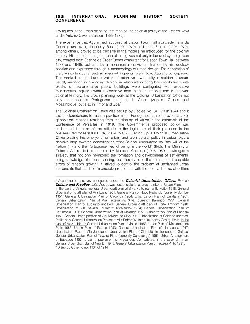
3. THE GENERAL URBANIZATION PLAN FOR LORENZO MARQUES OF 1955
Figure 1- AGUIAR, João António (1906-1074) “Plano Geral de Urbanizção de Lourenço Marques – Perspectiva do Centro Cívico”, 1955 (0,420x0,20)
The General Urbanization Plan for Lorenzo Marques was drawn up in light of its geographical situation and its development potential. However, the urban action was achieved in a delimited area near the city’s generative center; it served as a plan that defined not only the opening up of new areas of buildings but also concrete action redefining the urban design of some sectors of the city and hence urban modeling and architectonic expression.
From the methodological standpoint, territorial and social surveys and analyses were conducted with the aim of formulating a measurable standard of the 771,125 km2 that make up the Mozambique territory; this included hydrography and orography, and maritime19, river20, terrestrial and railway communications. From the social standpoint, a sample was made of the various ethnic and indigenous tribes21 based on a 1945 census. The data obtained revealed that “non-indigenous” people in Mozambican territory were a tiny minority (less than 2%), although this was less
19 The case of the Ports of Lorenzo Marques, Inhambene, Beira, Chinde, Quelimane, Mozambique and Porto Amélia; 20 Reference is made above all to the case of the Zambezi River; 21 Population in 1940/45 was 5,094,294 persons, of whom 5,030,179 were native and 60,115 not native (European make up half of this number) – Tribes are: Tongas, Muchopes, Batongas, Sengas, Macuas, Angones, and Aianas.
C i t i e s , n a t i o n s a n d r e g i o n s i n p l a n n i n g h i s t o r y
so in Lorenzo Marques22 where around 35% of all inhabitants were “non-indigenous”.
The over-riding justification for drawing up the plan was the exponential increase in the revenue from the Port of Lorenzo Marques between 1937 and 194823; this was due to the city’s privileged geographic situation, serving as the trading station for South Africa and Swaziland. This economic and strategic boom justified a highly expansionist plan of action in which the Costa do Sol, the northeast of the city, was the main area of development. The prolonging of Av. Elias Garcia (now Av. Vladimir Lenine), structured the design of a set of other axes and new urban hubs which intersected at roundabouts, opening new fronts of buildings in which the typologies of quarters and imposing buildings played a key role. The plan was confined to the north with the extended Estrada de Marracuene, known in the plan as Rua D.
Another argument underlying this Urbanization Plan was the marked increase in tourism which was expected to be even more “abundant due to the white population, the excellent hotel facilities, the state’s heavy investment in prominent buildings, the urban setting – where squares [alternated with] quarters intersected with wide boulevards” (AGUIAR, 1955). The plan revealed that areas would be reserved for the construction of private buildings such as cinemas, hotels, guilds or garages as long as they had “monumental architectural features” (ibid).
According to the plan, the development of the Costa do Sol would take place in two stages, which would be articulated on the basis of the topography. It envisaged the occupation firstly of the highest area, the west, leaving the coastal strip for a second phase. Although this lower area of the city was practically horizontal, it dipped in some places to slightly below high tide level and was therefore not as suitable as the High area which had some elevations of over 20m. The lower part of the city, overlooking the Indian Ocean, had already been cleared and infrastructures built and it also benefitted from the fresh sea breezes. Nevertheless, it seemed that João Aguiar’s team was keen to preserve the seafront as they realized the potential of turning the long, broad strip of sands into “Lorenzo Marques Beach".
The urbanization of this Costa do Sol area would be dominated by a moment of great importance, namely the building of a Civic Center, that could attract facilities for official buildings and tourism (such as hotels, blocks of flats for renting, cinemas and casinos) to high ground. An access road, also lined with similar buildings, would go from there to the beach.
All residential streets with local traffic were required to have a minimum width of 12 meters, thus giving a feeling of grandeur and space. However, there was a hierarchy of roads based on the main hubs, which corresponded to the plan’s main axes; at their intersections, they generated a set of new triangular sectors where new “Residential Units” would be located. These were all served by schools, parks and commercial centers of local interest.
22 Total population in Lorenzo Marques in 1945 was 69,861 persons, of whom 45,070 were native and 24,791 not native (with the following distribution: 16,149 Europeans, 644 Asian, 2.806 Indo-Portuguese, 1133 Hindus, 3548 Mixed race, 511 African); 23 The gross profit of the Port of Lorenzo Marques went from 22,206,666.$00 (�€110,766.38) in 1937, to 39,235,688$00 (�€195,706.78) in 1947 and 38,187,894$00 (�€190,480.41) in 1948;
1 5 t h I N T E R N A T I O N A L P L A N N I N G H I S T O R Y S O C I E T Y C O N F E R E N C E
The typology of the model was to develop high-rise public and service buildings, contrasting with the predominantly horizontal residential units of houses or contiguous housing. More sporadic, though large-scale, work would take place in the existing areas of the city that intersected with the new plan; this started with the “three residential units of Malhangalene, Alto Maé and Lagoas. Improvements [were planned] for the urban areas of the aforementioned residential areas, namely the removal of some roads and the repair of those that remained, as well as the elimination of cubatas (huts), thus cleaning up and standardizing the blocks.” (ibid) Four additional residential centers, though of less importance, were also envisaged.
There were also plans to build a large square in the heart of the city called Praça do Centro Oficial, creating a new urban setting for administrative and reception buildings. Accordingly, a new administrative and representative center would be transferred to the southeast from the station square and 7 de Março square (now 25 de Junho square). Lisbon’s Praça do Comércio was the model adopted for this new “imperial” square, albeit using a more rectangular typology. The square would be open to the sea with majestic buildings lining its three other sides; this framed symmetrically arranged gardens that accentuated the verticality of the central building and with an obelisk topped by an armillary sphere (representing the epic Portuguese discoveries of the 15th and 16th centuries). This sector of the plan represented the stylistic features of the intervention as a whole, with the graphic simulation of this urban moment serving as the frontispiece of the actual plan.
The Urbanization Plan for Lorenzo Marques was also an opportunity to try out a methodology for working with what were considered to be Mozambique’s indigenous communities. Framing the issue, an approach was made on the relations between the “indigenous” and “non-indigenous” populations, considering that in the interest of cordial relations, "the latter were not afraid to accept indigenous people into their homes for the different kinds of domestic service”(ibid)24. The asymmetry in their dwellings mirrored the stark differences in the material resources of the two social communities.
The popular neighborhoods were located mainly in the suburbs, although it was usual for some “domestic staff [to occupy] premises (bedroom with shower and toilet) at the back of the buildings, usually separate from the main house; alternatively, inside the main residence in the basement or on the top floor when there was not enough land”. Commuting was common between the center and the outskirts of the town as “the women [that] work[ed] in the city [usually] returned there every night”(Ibid).
The anthropological and social understanding of the living habits of the native population was unclear; their dwellings were generally defined as rectangular or circular huts built using “a large variety of materials, many of which had come from demolitions in the city: stone, brick, wood, thatch and galvanized sheeting, and few had a tiled roof or reinforced concrete”.
There are also records of the organization of some residential clusters such as the Xipamanine neighborhood on the Zixaxa road, which was the first attempt to
24 As a rule, there were three persons on the domestic staff: the "moleque", the cook and the "mainato". The first cleaned the house, served at table and ran messages; the second did the cooking and the shopping, and the "mainato" did the washing and ironing.

C i t i e s , n a t i o n s a n d r e g i o n s i n p l a n n i n g h i s t o r y
organize “indigenous” housing in the Lorenzo Marques council, or the Munhuana neighborhood that resulted from an official initiative.
It was the location of these popular residential clusters that was most controversial; the Plan advocated that they should be situated nearer the city center, so that the energy expended [on commuting would not influence] productivity”. On the other hand, it was thought that a more central location in new neighborhoods would further the rise “in the social status of the indigenous population”.
The differences in the way Lorenzo Marques territory was planned were not only in the regionalist attitude taken, but also the assumptions about the housing for the local populations. Unlike João Aguiar, Mário de Azevedo developed a strategy that was based on a more inclusive model.
4. THE MASTER PLAN FOR LORENZO MARQUES OF 1969
The methodology adopted in the Master Plan for Lorenzo Marques of 1969 reflects the changes that had taken place when it was drafted. A fresh approach was taken to urban planning, introducing a development strategy as an innovation criterion based on a large-scale interpretation of the territory and its physical and economic potential25.
A multi-disciplinary team was assembled to support this strategy. In addition to Mário de Azevedo, the team included the aforementioned Ponce Dentinho in the landscape field, Alberto Nascimento in traffic, Óscar Barata for demographic issues, João Neto for the sociology scope and Alfredo Lima for historical studies. “This was followed by the appointment of a number of architects: José Brusky in October 1967, assigned as deputy town planner responsible for coordinating the local team; subsequently, in May 1968, Carlos Chaves de Almeida joined the office and then António Barata Feio and Jorge Silva the following February. In the initial phase, Luís Amaral, Firmino Trabuco and Luís Vasconcelos collaborated in partial studies or survey work, together with M. Sepúlveda who worked on a part-time basis. António Matos Veloso also contributed to the survey with freelance work”(AZEVEDO, 1970). The team’s disciplinary scope could be seen in the dialogue among the various agents represented in the city, who it was thought essential to involve.
25 The Master Plan of Lorenzo Marques is organized in 6 chapters distributed in 23 volumes in which the procedural organization reflects a great sense of methodological innovation. It is organized as follows: Regional Studies (Vol. I, II; III); Survey (Vol. IV, V); Sectorial Studies (Vol. VI, VII, VIII, IX, X, XI); Analysis of the Territory’s Aptitude (Vol. XII, XIII, XIV; XV; XVI); General Plans (Vol. XVII); Guidelines for the development of the Plan and the Local Studies + Summaries and General Reports (Vol. XVIII, XIX, XX; XXI; XXII; XXIII);

1 5 t h I N T E R N A T I O N A L P L A N N I N G H I S T O R Y S O C I E T Y C O N F E R E N C E
Figure 2 – AZEVEDO, Mario de (1924-2007) “Plano Director de Urbanizção de Lourenço Marques”, 1969 (0,20x0,15) in AZEVEDO, Mário “Enquadramento Regional da Cidade” in AAVV. Municipal Master Plan for Lorenzo Marques, Municipal Bulletin - Organization of Cultural and Propaganda Sections, Lorenzo Marques Town Hall Edition, December 1970;
The humanism in Mário de Azevedo’s discourse was underpinned by the inevitable population growth of the overseas province of Mozambique and the resulting interdependence of communities on the territory. The emphasis given to the city’s strategic location is very significant, returning to the idea already conveyed in the 1955 Urban Plan, coordinated by João Aguiar, and which was still officially in force.
However, other studies prior to Mário de Azevedo’s Plan also provided an essential support base for the new urban planning instrument. For example, the architects Veiga Camelo and Fernando Mesquita had supervised studies “that marked a decisive stage in urban planning, going beyond the conception of a city closed in itself, of limited size and structure” (Ibid) that to some extent characterized the João Aguiar Plan. The solutions outlined by the Town Hall’s Office of Urban Development and the by the Regulatory Plan Committee for Land Use in the Surroundings of Lorenzo Marques (PROSALM) were also taken into account26.
26 PROSALM –Regulatory Plan for the Land Use in the surroundings of Lorenzo Marques - was an organism set up in 1953 by Decree of the General Governor. PROSALM worked as a Committee on which the Presidents of the Lorenzo Marques and Matola Municipalities sat, as

C i t i e s , n a t i o n s a n d r e g i o n s i n p l a n n i n g h i s t o r y
The essence of the Master Plan was to provide the city with road and sanitation infrastructures, structuring interventions on the basis of the vocation of the land. From the first, the idea of “zoning” and “specialization” was set aside and preference given to defining the most favorable areas for urban development, generally following the main communication lines that served as long-term lines of population growth. (AZEVEDO, 1981)
In 1967, the uncertainty of war and the decolonization phenomenon meant that the pace of population growth of the 1950s and 1960s was expected to continue, with the number of urban dwellers reaching 700,000 in 1980.
Planning for the road network aimed to join the city’s roads to the north (Beira) and Northwest (Johannesburg) in a single insertion; economic factors and phasing remained key criteria for the proposed route. The initial section of this route also met local constraints and was part of a natural sanitation proposal for the central area of the urban hub (AZEVEDO, 1970). It was decided that the connections between Lorenzo Marques and Swaziland should favor the link via Goba, at the expense of penetration towards Namacha. “These two connections together, from Lorenzo Marques to the north and south, [corresponding] to the long tangential axis to the coast and the city, [could] support all the regional traffic and [join up] at the crossing of the Espírito Santo estuary in a topographically favorable location, still relatively free of buildings and not far from the heart of the settlement” (Ibid).
From the access and flow management standpoint, consideration was also given to constructing a new airport and maintaining the existing rail track, with particular emphasis on sections that could affect the structure of settlements in Lorenzo Marques.
The structuring of urban flows provided the framework for large leisure areas along the coast, with indications for their appropriate treatment and the necessary preservation of natural resources. It was thought that “the island of Inhaca and its surrounding maritime areas warranted special mention. Because of its privileged position in relation to the bay and the city, as well as its exceptional natural assets, [it was important] to establish secure legal protection and a deliberate valorization policy that fully respected the features that [distinguish] Inhaca as a privileged place of rest and scientific interest” (Ibid)27.
As Lorenzo Marques was a recent city, traces of past values did not impose many constraints on the action plan. The current situation of the city reflected “the two trends in planning that marked the city’s first steps: leaving the initial site which was unhealthy and difficult to improve, in search of higher ground; or the sanitation of the existing dwelling area and its continued development using landfill and draining the wetlands. The existing situations and interests, together with the city’s evident vocation as a harbor, were undoubtedly key factors in the preference given to the latter solution through the bold “Araújo Plan”, the certainty with which its directives
well as the President of the Public Works Services and the Delegate of the Public Prosecutor and the architects Craveiro Lopes and Moreira Veloso; 27 See DN dated 11 November 89 Maputo Cidade Aberta nas Margens do Índico, which refers to the interest in Inhaca, visited by a team of Portuguese dignitories. Samora Machel lived in Inhaca between 1956 and 58 where he practiced as a nurse. Inhaca was a safe haven for war refugees;

1 5 t h I N T E R N A T I O N A L P L A N N I N G H I S T O R Y S O C I E T Y C O N F E R E N C E
were accepted and implemented by authorities, and the compliance and adherence of the local people” (Ibid). The plan proposed to give the old neighborhood of “Baixa”, where signs of the past were still more apparent, special status and regulations supported by plans for special plots. Pedestrian areas were to be introduced by closing some streets to traffic, and moving the circulation of traffic to the periphery; only certain slow traffic flows would be allowed there to further its desired valorization.
Another feature of the Master Plan for the Urbanization of Lorenzo Marques was that it included the reed settlements and traditional housing in the general planning logic. The urban center had already been invaded by dense areas of precarious and ungoverned housing extending over 1000 ha, (using traditional or other methods of construction); the so-called “under-integrated areas” were of varying dimensions and rose up in rapidly growing settlements that required appropriate treatment. The local administration services therefore had instructions to give these areas community facilities and infrastructures; this was in line with United Nations guidelines which provided evidence that people in less developed economies will put any small savings into housing if investments are made to improve community facilities (AZEVEDO, 1981). Knowledge of the true extent of the traditional housing was obtained using a methodology based on topographic maps and aerial photographs of a vast area of 11,000 ha of traditional housing. A detailed analysis was then made to determine the extension of walls, fences, stable walls, walkways and the different types of housing, as well as the area of agricultural land and the other characteristics of a spontaneous occupation density and their structural differences (Ibid).
5. “NOUS, NOUS SOMMES MIS DU CÔTÉ DES USAGERS” (Ibid)
The urban phenomenon for Mário de Azevedo was based on the assumption that the city is built as part of a systemic process of regeneration. Infrastructures thus intersect with a broad interpretation of the territory, from which orientations resulting from the settling of time are drawn. This settling is brought about by the biophysical configuration and man’s presence.
Aguiar’s Urbanization Plans and Azevedo’s Master Plan allow us to identify two distinct moments in the development of the Lorenzo Marques territory. The monumental centralism advocated by Aguiar evolved to the breadth and diversity in Azevedo’s proposal, thus reflecting a line of continuity in Portuguese urbanist thinking. While the former is an ambitious gesture marked by development and the laying of new foundations, the latter’s action is intensely focused on correcting the existing situation.
For João Aguiar, the city is simply “a large house” - as Alberti called it – a kind of architectural fact structured by the delimitation of the urban design. Here boulevards, roundabouts and squares served as structuring elements of a form of Portuguese interpretation of a functional city that was able to incorporate the tradition of the City Beautiful, which is drawn on extensively in the plans of the 1920s and 1930s (during the I Republic). In contrast, Mário de Azevedo goes beyond the area of design and assumes an analytical dimension that implies using a varied range of localized interventions.
C i t i e s , n a t i o n s a n d r e g i o n s i n p l a n n i n g h i s t o r y
Mário de Azevedo wonders whether this process could be understood as a sequence to Ville Nomade introduced by the Situationist movement and called upon by Constant in “New Babylon” (Ibid). Or on the other hand, whether there is simply a desire to go beyond the usual formulas of urbanism so as to bestow mankind with greater freedom of action by constantly transforming the ways in which urban space is developed. “The Utopian urbanism of the great architectural design is centralizing and collectivist, unlike the Utopian urbanism of the users” (Ibid). Thus, it is the users that determine the basis of new urban dynamics.
Azevedo’s idealism has a maturity that is more realistic than Constant’s utopia, but his proposal results from the belief in a shift that made a creative change possible. This change embraced diversity and resulted from ongoing interventions in neighborhoods, quarters or even on quiet corners.
On reconnait de plus en plus l’intérêt pour nos villes de réaliser des programmes d’interventions ponctuelles – ce que j’ai déjà entendu appeler, par similitude aux méthodes de la médecine chinoise, “d’acuponcture urbanistique”(Ibid).
REFERENCES
AGUIAR, João António (1955) “Plano Geral de Urbanização de Lourenço Marques”, drawings and texts, consulted in the IHRU Historical Archive at Forte de Sacavém,;
AZEVEDO, Mário (1969) “Plano Director de Urbanização de Lourenço Marques”, XXIII volumes, consulted in the IHRU Historical Archive at Forte de Sacavém,
AZEVEDO, Mário de (1967)“Plano Director da Região de Lisboa” in AA.VV. Binário nº 108 September;
AZEVEDO, Mário (1970) “Enquadramento Regional da Cidade” in AAVV. Municipal Master Plan for Lorenzo Marques, Municipal Bulletin - Organization of Cultural and Propaganda Sections, Lorenzo Marques Town Hall Edition, December;
AZEVEDO, Mário de (1971) “Planeamento urbanísitico e custos de infraestruturas” in AA.VV Binário nº 161, de February;
AZEVEDO, Mário (1981) Etude et Prat ique de L’urbanisme un Temoigene: Seance Academique Rentree de L’ inst i tut Superieur d’Architecture Victor Horta , Brussels, 1981;
CAETANO, Miguel de Barros (2008) “O Planeamento Regional em Portugal no Período do III Plano de Fomento”, in Estudos de Homenagem ao Professor Doutor Paulo de Pit ta e Cunha , Lisboa: Divisa de Informação e Comunicação – Departamento de Prospectiva e Planeamento e Relações Internacionais;

1 5 t h I N T E R N A T I O N A L P L A N N I N G H I S T O R Y S O C I E T Y C O N F E R E N C E
LÔBO, Margarida Souza (1995) Os Planos de Urbanização à Época de Duarte Pacheco , FAUP, Porto;
MILHEIRO, Ana Vaz; DIAS, Eduardo Costa, (2009), “Arquitectura em Bissau e os Gabinetes de Urbanização Colonial (1944-1974)”, in arq.urb, nº2, 80-114 (http://www.usjt.br/arq.urb/numero_02/artigo_ana.pdf)
MORAIS, João Sousa (2001) Maputo Patr imónio e Forma Urbana Topologia do Lugar , Livros Horizonte;
MOREIRA, Adriano (2009) A Espuma do Tempo – Memorias do Tempo de Vésperas , Almedina, Coimbra;