freedom to create space to think awards 2017 · space to think freedom to create unit 4, 1st floor,...
TRANSCRIPT

nationalUrban Design
awarDs2017
Urban Design groUp
Urban Design groUp
SPACE TO THINK FREEDOM TO CREATE
Unit 4, 1st Floor, Marshalls Design Space, 40 Compton Street, Clerkenwell, EC1V 0BD
Telephone: 020 8712 1335
Email: [email protected]
Web: marshalls.co.uk/designspace
Marshalls Design Space is an exclusive venue for architects and design professionals. A space to explore and experiment with materials, colours and textures. A space where imagination comes alive. And with a calendar of bookable events, guest speakers and CPD seminars, it’s a space to learn too.
Call 020 8712 1335 or visit marshalls.co.uk/designspace to reserve your free space.

News
national Urban Design awarDs ― 2017
The National Urban Design Awards are an important part of the Urban Design Group (UDG) calendar, providing an opportunity to reach out to members and draw upon the best in emerging urban design practice from the industry, students, writers and their publishers. Thank you to all those that afforded the time and effort to prepare their submissions for this year’s awards which, as ever, were of a very high standard. We appreciate your contribution to helping make these awards a continued success and look forward to entries for next years’ awards.
The need for good urban design in the built environment is so often regarded as a given, there is rarely the opportunity to reward the effort required to achieve it, particularly when demands conflict and political will or support is lacking. It is therefore important that best practice in urban design is recognised, for the positive effects are far reaching, touching not just those that will live and work in our built environments today, but for future generations. It is no coincidence that the best designed places are the most popular and enduring.
The awards were established in 2007 by the Urban Design Group’s founder member and fellow John Billingham with the objective of giving more recognition to urban design work. The award was supported by the Francis Tibbalds Trust, with a prize of £1000 for the winner and the first Practice Award was presented to Urban Practitioners in September 2008 at the Gallery, Cowcross Street. Since 2008 the awards have developed to reflect the scale and importance of urban design work, covering the public and private sector, student projects and publications. In 2013 the UDG welcomed Noha Nasser as chair of the Urban
Design Awards Working Group, taking over from John Billingham, and the awards moved to a larger venue. They have been held at the Victory Services Club now for three years.
Recent Practice Award winners include Baca (2016) for their project at Eiland veur Lent, Nijmegen, Netherlands and IBI (2016) for their work at Barnsley Town Centre. URBED won this award in (2015) for their project at Trent Basin, Nottingham. Recent Public Sector Award winners include Stockton Borough Council (2016 – Stockton High Street Regeneration) and Birmingham City Council (2015 – Birmingham Municipal Housing Trust). Publications that have been recognised include: Young – Old: Urban Utopias of an Ageing Society by Deane Simpson (2016 – Lars Müller Publishers) and Smart Cities: Big data, civic hackers, and the quest for a new utopia by Anthony Townsend (2015 – W M Norton & Company).
The Lifetime Achievement Award recognises a significant contribution to urban design. Previous winners include Sir Terry Farrell (2015) and Bill Hillier (2016) and Professor Christopher Alexander (2011). The group has been fortunate that many of the Lifetime Achievement Award winners have followed the Award with a seminal lecture to members.
The awards go from strength to strength and with the continued support and generosity of the Francis Tibbalds Trust, we remain true to our goals of recognising and rewarding the very best in urban design practice and encouraging collaboration, innovation and the sharing of ideas.•
Colin Pullan, Chair of the UDG
welcome to the national Urban Design awards 2017

1Contents
national Urban Design Awards shortlisted entries 2017
How to Vote for your Winners1. Remember to choose your preferred entries for the Practice Project and Public Sector Awards on the basis of:• Their contribution to urban design thought and ideas• The principles on which the project is based• The process – how well the project has been developed • Lessons learned
2. Vote using this http://www.udg.org.uk/UDA2017Vote Now! Voting will close at midnight GMT on Friday 24 February 2017
sHoRtLIsteD PRACtICe PRoJeCt entRIes2 — Mulberry Park and Foxhill Estate Regeneration,
HTA Design LLP4 — Knowledge Hub Masterplan, Node6 — Regents Park Estate, Camden, Tibbalds Planning
and Urban Design8 — Vaux Brewery, Sunderland, URBED
sHoRtLIsteD PUBLIC seCtoR entRIes10 — Connected Croydon, London Borough of Croydon
Council12 — Plymouth City Centre & Waterfront Masterplans,
Plymouth City Council14 — South Oxfordshire Design Guide, South Oxfordshire
District Council16 — Swindon: Residential Design Guide, Swindon
Borough Council
sHoRtLIsteD stUDent entRIes18 — Charlton Riverside Masterplan, Brian Yuen,
Douglas Lee, Cassie Tang and Wilson Wong20 — Lanes You’ll Love, Jo White22 — Athens: Landscape City, Lucy Feinberg
sHoRtLIsteD BooKs24 — Human Ecology – How Nature and Culture Sshape our
World, Frederick Steiner24 — Zoning Rules! The Economics of Land Use Regulation,
William A. Fischel25 — Concurrent Urbanities, Designing Infrastructures of
Inclusion, Ed. Miodrag Mitrasinovic25 — The Urban Climatic Map: A Methodology for Sustainable
Urban Planning, Ed. Edward Ng and Chao Ren26 — Housing Cairo: The Informal Response, Ed. Marc Angelil
and Charlotte Malterre-Barthes 2627 — Infratecture, Infrastructure by Design, Marc Verheijen27 — Landscape as Urbanism: A General Theory, Charles
Waldheim28 — Sharing Cities – A Case for Truly Smart and Sustainable
Cities, Duncan McLaren and Julian Agyeman
29 — tHe JUDgIng PRoCess exPLAIneD Recognising Excellence through the National Urban Design Awards
31 — Common PItfALLs Reviewing Award Submissions
32 — fRAnCIs tIBBALDs
We would like to thank the National Urban Design Awards judging panel for 2016–7 for their hard work selecting the shortlisted entries for the Practice Project, Public Sector and Student Awards published here:sebastian Loew (chair)Lindsay Whitelaw (UDg Patron)manuela maddedu, London south Bank University
(representing education)marcus Wilshere, IBI group (2016 Practice Award
co-winner)Richard Coutts, Baca (2016 Practice Award co-winner) Anthony Philips, stockton District Council
(2016 Public sector winner)malcolm moor (Practice Project Award convenor)Ben van Bruggen (Public sector Award convenor)graham smith (student Award convenor)Louie sieh (Book Award convenor)
The Book Award judges were Louie sieh (chair), marc furnival, Juliet Bidgood,Jonathan Kendall and georgia Butina-Watson.
We are grateful to our sponsors, whose generosity has supported this publication and the Awards ceremony.

national Urban Design awarDs ― shortlisteD entries 2017
2
national Urban Design awarDs ― 2017
2 sHoRtLIsteD PRACtICe PRoJeCt entRIes
mulberry Park and foxhill estate RegenerationHTA Design‘s plans regenerate a housing estate using nearby brownfield land to form a new neighbourhood
ContextFoxhill is a post war housing estate located about one-mile south of the centre of Bath, on top of a hill within the village of Combe Down. It has suffered from isolation from the surrounding areas, with only two access points, and has been blocked from the vil-lage by the previously impenetrable Ministry of Defence Foxhill site. The existing homes on the estate are in poor condition, expen-sive to maintain and repair, so the neigh-bourhood has declined with an increasing turnover of tenants and an increase in anti-social behaviour. Therefore, the area was fortunate to be given Housing Zone status by the HCA in 2016.
In 2013 the not-for-profit housing and support organisation, Curo bought the va-cated MoD site. Curo, already owned 60 per cent of the homes on the neighbouring Fox-hill estate, saw an opportunity in developing the MoD site in a manner that would enable the regeneration of the estate and enrich the neighbourhood with new facilities, benefit-ting both the existing and new community. HTA took part in a selection process that included a presentation to local community representatives at the end of 2013 and was appointed in January 2014 to develop a mas-terplan (later to be progressed to planning application) that would encompass both the MoD site and the Foxhill estate.
PLAnnIng AnD PHAsIngOutline planning permission was granted unanimously in early 2015 for the MoD site, which was renamed Mulberry Park. Reserved matters approval for the first phase of new homes on Mulberry Park was granted in the autumn of 2015. This phase is now under con-struction and the first homes will be ready for occupation in 2017. An outline planning application covering a regeneration area within the Foxhill estate was submitted in the autumn of 2016, and a decision is awaited for early 2017. Both sites comprise six to seven phases; each which will be developed in an alternating manner, allow for the creation of
new homes within the vicinity of the existing homes. It is Curo’s intention that Foxhill’s residents will be able to remain in the area, and would only have to move once.
tHe mAsteRPLAnThe first workshops with residents facili-tated the spatial planning and involved both sites, to establish the key principles for the overall masterplan, which included new entrances into the sites emphasised by landmarks, strong links across the sites, a new large open space located centrally to be easily accessible for everyone, community facilities located close to the existing sports club to enable a share of facilities, and new connections – whether for cars, cyclists or pedestrians – into the surrounding areas of Combe Down. Based on these principles HTA began the development of an overall vision masterplan, which combined Mulberry Park (the former MoD site) and the Foxhill estate. A key component of this was ensuring the regeneration was viable and to achieve this, we analysed Curo’s ownership across the Foxhill estate, and established the regenera-tion area in the parts of the estate where their ownership is highest. This area became the focus of the regeneration and is nested within the overall vision masterplan.
Based on a clear and legible hierarchy of streets, the masterplan creates new north-south connections linking Combe Down to the south to existing and new green spaces to the north. These links include a new tree lined boulevard leading into Mulberry Park from a new roundabout on Bradford Road northwards to central green open spaces. On the estate, a new site entrance is cre-ated and joined to the current Queens Drive which is being reconfigured to provide the main avenue for Foxhill and a new connec-tion to Springfield Park to the north. The existing Fox Hill Road remains and provides the third entry point between the new Mul-berry Park and the regeneration area of the Foxhill estate.
A series of east-west links knit Mulberry
Park and the Foxhill Estate together while connecting the open spaces. The principal connection is a new community spine be-tween a new Garden Square in Mulberry Park and a corresponding square at the heart of the Foxhill Estate. The Garden Square in Mulberry Park is fronted by a new primary school and community hub, designed by BDP, due to open at the end of 2018. Within Mulberry Park a new spine road at the north of the site connects the eastern extension of the development back to the Central Park.
Between the primary north-south and east-west connections a network of shared surface lanes and pedestrian routes form the rest of the masterplan and maximise the links to the surrounding neighbourhoods.
Key to the masterplan is the formal Cen-tral Park which acts as a bridge between the Foxhill Estate and Mulberry Park and is defined by the encircling crescents which wrap along the South of the space. In ad-dition to this a Woodland Walk along the northern edge of Mulberry Park provides in-formal counterpoint of natural open spaces. Smaller local green spaces are distributed along the key routes throughout the neigh-bourhoods providing natural doorstep play for younger children and informal places for neighbours to meet. A new green space acts creates a gateway from the redeveloped Foxhill Estate to Springfield Park to the north of the estate, a landscape asset with views looking back to the City centre which had previously been difficult to access. Phase 1 of Mulberry Park opens up access to Back-stones, an existing open space, and creates a new active frontage around it.
As the site is located within the World Heritage site of the City of Bath, the pro-posed height of the buildings on these slopes have been rigorously tested with Visual Impact Assessments as part of the Environmental Statements for both applica-tions. Proposed heights vary from two to six storeys with the greater heights concen-trated around open spaces, particularly the Central Park.
1

shortlisted entries 2017 ― national Urban design awards
3shortlisted Practice Project entries
2017 ― national Urban design awards
3
stReet AnD Home tyPesDwellings are designed to establish a new model for greater density in suburban developments, adapting the qualities of traditional housing so prevalent in the city of Bath, to meet the needs of contemporary family living. The average density across the combined masterplan is approximately 55 dwellings per hectare. These densities are achieved through a diverse mixture of street and housing typologies from avenues lined with townhouses arranged as paired villas, mews fronted by coach houses, mansion and pavilion flat blocks around garden squares, smaller flat blocks creating corners, shared surface streets fronted by a combination of terraces and semi-detached cottages and detached houses around the fringes. Crescents and circus are introduced as set pieces within the development refer-encing Bath’s rich heritage of urban forms. The modern designs of the homes is en-riched with simple details that reference the context including corbelled brick, shadow gaps, larger picture windows and clipped eaves. Bath stone is used selectively to articulate key elements of the design and is used with a complimentary palette of care-fully selected brick and mortar variations
to ensure a sympathetic relationship to the context.
Within Mulberry Park 65% of the new homes will be houses and 35% flats accom-modated in small blocks, with 30% of the homes being affordable. Different tenan-cies are indistinguishable and distributed throughout the scheme. Nestling within the semi-rural village setting, the first phase will deliver 275 homes out of 1400, and will establish the character of the masterplan by providing the gateway and visual signal of the regeneration to Bradford Road the pri-mary road serving Combe Down.
As the regeneration area of Foxhill is still being considered for Outline planning permission, the first phase has yet to be fi-nalised but is likely to be at the north-west corner, and is designed to complete the frontage to the Central Park and create a strong connection between Mulberry Park and the Foxhill Estate Regeneration. This will facilitate the removal of existing flat blocks which are some of the least popular homes on the estate and provide the opportunity for a large number of new homes. Future phases will likely extend from this starting point in a gradual process working from east to west.
Lesson LeARneDInvolving the local community was at the foundation of Curo’s process for the mas-terplan. However, in seeking transparency and community engagement at early stages in the design process there were instances where this created a desire from the local stakeholders for answers and certainty, which simply weren’t available at those stages of design and planning. Our key lesson has therefore been to caution com-munity engagement too early in the project until clear answers to the questions around phasing and decant can be offered and when real progress can be demonstrated that lo-cal people can engage with.•
1 Illustrations of the different character areas2 Illustrative nested masterplan3 50 year vision masterplan4 Phasing5 Urban design concept diagram 6 Bird’s eye view illustration of Phase 1
2
3
4
5 6

national Urban Design awarDs ― shortlisteD entries 2017
4 shortlisted Practice Project entries
national Urban design awards ― 2017
4
Knowledge Hub masterplanA collaborative design by Node for a ‘place for learning’ within one of Europe’s youngest cities: Birmingham
mUCH DeVeLoPment; LIttLe PLAnnIngThe Knowledge Hub began life as a visioning study to test the possibilities and potential of an area of Birmingham which has been the focus of significant levels of investment and largely ad hoc development, resulting in a fractured, but vibrant quarter of the city. The area is home to many knowledge based insti-tutions including Birmingham City University (BCU) who commissioned the study, Aston University, Millennium Point, Birmingham Metropolitan College, Birmingham Ormiston Academy, Innovation Birmingham and the wider Birmingham Science Park, as well as providing the future site of the HS2 rail terminus. The project sought to pro-actively and coherently plan for the area’s future and create a unified campus environment.
CoLLABoRAtIonThe project team comprised members of BCU's academic staff, students and Node’s consultants. From the outset, we worked collaboratively to research the multi-layered local context, including assessing existing development by undertaking a Placecheck exercise, which helped to define the bound-ary of the study area through identifying complementary uses and sites that would
benefit from inclusion, together with looking at the fourth dimension of time, through analysis of the area’s history and its plans for future development. Working closely with BCU's academics gave a further experien-tial dimension to the contextual analysis, through investigations into smellscape and soundscape. These innovative methods and thinking, coupled with extensive stakeholder engagement, led to a deep understanding of the area which enabled the creation of five key themes to guide the masterplan: learning; health and wellbeing; innova-tion and creativity; enterprise; and culture. Flowing from these themes came a series of objectives, which were tuned to the varied needs of the broad range of stakeholders. These objectives are concerned with issues such as the creation of a coherent identity; enhancing the arrival experience; improv-ing connectivity into, through and out of the site; making pedestrians and cyclists the priority; enhancing the setting of landmarks; and considering the design of key nodes.
Key moVesThe objectives allowed the definition of nine ‘key moves’, which collectively form a mas-terplan that creates the cohesive campus of the Knowledge Hub: an area that will be
clearly unified and recognisable . Each key move anchors one of six designated routes across the area, connecting various local nodes through a series of new spaces and enhanced public realm. These are as follows:1. Corporation Plaza – a new public space
and gateway to the Knowledge Hub that prioritises pedestrians and cyclists
2. Aston Central Square – a new space at the heart of Aston University that will provide a new arrival / orientation space with information pavilion/ cafe
3. iCentrum – A new space that will allow for outdoor exhibitions in an amphitheatre setting, to help support new start-ups and established businesses that work within this newly developed building
4. Jennens Park – A new linear park reclaim-ing space from the car with an emphasis on play for all ages and creating a sense of fun and delight. It will include an urban playground with cycle routes, fitness equipment and new green spaces that will help stitch the Knowledge Hub together
5. Jennens Gateway – The transformation of an unattractive and unsafe road junction into a well-connected space with pedes-trians and cyclists given greater priority
6. The Forum – an exciting activity node with opportunity for markets, external digital
1

shortlisted entries 2017 ― national Urban design awards
5shortlisted Practice Project entries
2017 ― national Urban design awards
5
screen and night-time events7. Curzon Street – The creation of an ex-
tended Eastside Park linking to develop-ment associated with HS2
8. Eastside Locks – A new mixed-use de-velopment including student housing, university buildings and other leisure uses linked to an improved environment along the canal
9. Typhoo Wharf– The conversion of a canal wharf building into the STEAMhouse crea-tive innovation centre, linking knowledge with enterprise, and the rejuvenation of the canal basin with a new public space.
DeLIVeRy PRoCessThe project was all about collaboration. Stakeholders at all levels, from the local authority right down to university students were directly involved in the creation of the Knowledge Hub masterplan, which has led to high levels of buy-in. The design team set up meetings and workshop events with landowners, operators and users of the area throughout the masterplanning process. We worked with students, not only to understand what they wanted from the masterplanning process, but to give them an experience of working on a live professional project. Their work gained national and international exposure when the project was featured in the press and at the international property conference MIPIM, where it was presented at the Greater Birmingham stand.
High-level support for the project has led to plans for a symposium to bring to-gether stakeholders with representatives of national government and the Treasury, to identify potential sources of funding and mechanisms for delivering this unique and ambitious project. The project has already secured £14m funding for Typhoo Wharf/STEAMhouse as announced in the March 2016 budget, and detailed proposals for the development of this exciting site and land-scape are underway.
Lessons LeARneDCollaboration was key for the project be-cause it helped us understand the diverse and multi-layered needs of the people who would use the place. Our collaborative anal-ysis process also made clear the importance of the dimension of time, and consideration of the sensory, experiential aspects of place.
Our engagement with users cemented our appreciation of the importance of pub-lic realm when designing for people. The
public realm is largely how people engage with a place and the Knowledge Hub has the opportunity to add significantly to the wider life of the city through a series of in-terventions and facilities that are lacking elsewhere in Birmingham.
Finally, we learnt that it is never too late for a masterplan. As urban designers, we ad-vocate for early involvement in the planning process, knowing that in doing so, we can
sensitively and coherently plan for an area’s future. Here, a masterplan was designed with much of the built environment already intact, but its value lies in connecting an area and its people, giving the public realm truly back to its users and defining a vision of a collective future in an environment that they – and the wider city of Birmingham can be rightly proud of.•
1 Visualisation of STEAMHouse at Typhoo Wharf2 Illustrative masterplan 3 Key moves
3
2

national Urban Design awarDs ― shortlisteD entries 2017
6 shortlisted Practice Project entries
national Urban design awards ― 2017
6
Regents Park estate, CamdenCity mending, estate visioning and an urgent need for new homes by Tibbalds Planning and Urban Design
The Regents Park Estate in Camden is a housing estate created to provide 2239 new homes in the post-war period. Originally planned in the 1950s, it was delivered in four distinct phases of varying success.
This London Borough of Camden es-tate is located in the area between Euston Station and Regent’s Park, several blocks north of the Euston Road. It is notable in that it replaced part of an earlier John Nash scheme following bomb damage. The remnants of this within the estate, include the three linked spaces of Cumberland Market, Clarence Gardens, and Munster Square (formerly York Square). Each of these are now challenged in some way by poorly considered interventions, includ-ing a 1990s GP surgery within one historic space, and post-war blocks sitting across key linked views between the two southern spaces.
Buildings on the estate vary in scale, quality and character, with the medium-rise blocks around Clarence Gardens being the most coherent. Many areas are difficult
1827
1
Ideas for long term opportunities
Short term housing sites
Positive historic buildings
Community facility
Active frontage
Public green open space
Public/ communal gardens
Communal green open space
Community-focused public squares
Car parks/hard landscaping
Trees
Key desire lines and visual links
Pedestrian links
Main Road
ALBANY STREET
ROBERT STREET
STANH
OPE STREET
HAM
PSTEAD RO
AD
DRUMMOND STREET
WILLIAM ROAD
VARNDELL STREET
REDHILL STREET
AUGUSTUS STREET
SHORT TERM PLANS AND LONGER TERM IDEAS
2
to navigate, there are complex changes in level and few clear or legible routes. The east-west Robert Street is the main route across the estate and an important link be-tween Regent’s Park and Euston.
tHe BRIefThe imperative to look at the potential for restructuring the estate and to create new homes came about through the proposed changes to Euston Station, that will see 184 homes on or near the estate needing to be demolished within three years.
The Council’s objectives for the project have been to develop a plan for provid-ing replacement homes for those residents whose homes will be lost, within 10 minutes walk of their current home, and in doing so to place this within a wider urban design strategy that ensures both the short term projects and longer term opportunities to improve the estate and help it to work bet-ter within its context. Residents and key local groups were engaged through all stag-es including design team selection.
PRoJeCt sCoPeTibbalds were initially asked to under-take a feasibility study and urban design review, looking for sites for around 150+ new homes within the estate. Through a rigorous process of urban design and wider context analysis, Tibbalds identi-fied the least effective parts of the estate today, as well as a series of short-term development sites. These needed to be free of existing development or significant obstacles as there was no time to relocate existing residents or overcome major constraints.
Three main opportunities for change were identified: firstly sites that could de-liver replacement housing within the short timescale required; secondly, medium term opportunities to provide additional homes where they are needed and pro-vide wider benefits; and finally a longer term vision that starts to identify a range of longer term opportunities to consider more significant restructuring of parts of the estate .
shortlisted entries 2017 ― national Urban design awards
7shortlisted Practice Project entries
2017 ― national Urban design awards
7
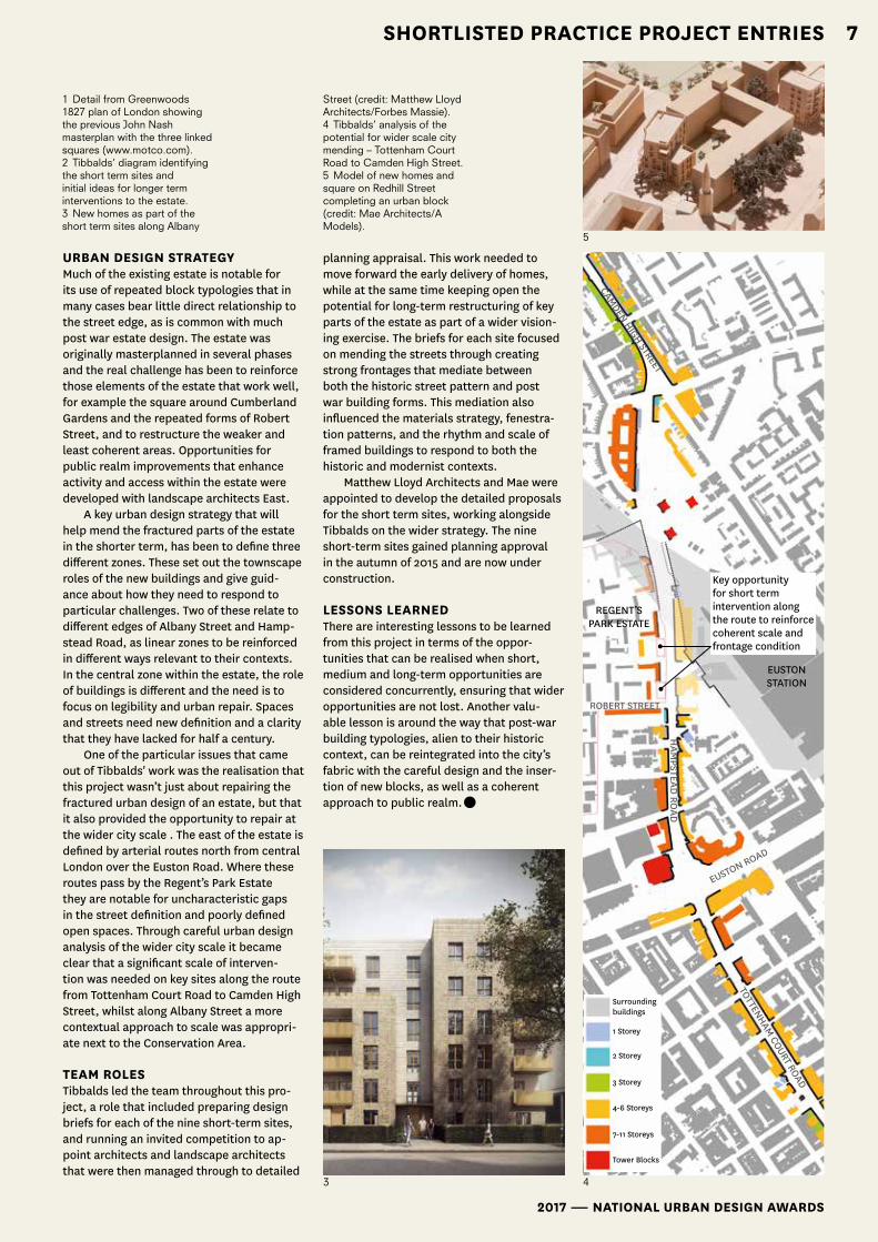
URBAn DesIgn stRAtegyMuch of the existing estate is notable for its use of repeated block typologies that in many cases bear little direct relationship to the street edge, as is common with much post war estate design. The estate was originally masterplanned in several phases and the real challenge has been to reinforce those elements of the estate that work well, for example the square around Cumberland Gardens and the repeated forms of Robert Street, and to restructure the weaker and least coherent areas. Opportunities for public realm improvements that enhance activity and access within the estate were developed with landscape architects East.
A key urban design strategy that will help mend the fractured parts of the estate in the shorter term, has been to define three different zones. These set out the townscape roles of the new buildings and give guid-ance about how they need to respond to particular challenges. Two of these relate to different edges of Albany Street and Hamp-stead Road, as linear zones to be reinforced in different ways relevant to their contexts. In the central zone within the estate, the role of buildings is different and the need is to focus on legibility and urban repair. Spaces and streets need new definition and a clarity that they have lacked for half a century.
One of the particular issues that came out of Tibbalds' work was the realisation that this project wasn’t just about repairing the fractured urban design of an estate, but that it also provided the opportunity to repair at the wider city scale . The east of the estate is defined by arterial routes north from central London over the Euston Road. Where these routes pass by the Regent’s Park Estate they are notable for uncharacteristic gaps in the street definition and poorly defined open spaces. Through careful urban design analysis of the wider city scale it became clear that a significant scale of interven-tion was needed on key sites along the route from Tottenham Court Road to Camden High Street, whilst along Albany Street a more contextual approach to scale was appropri-ate next to the Conservation Area.
teAm RoLesTibbalds led the team throughout this pro-ject, a role that included preparing design briefs for each of the nine short-term sites, and running an invited competition to ap-point architects and landscape architects that were then managed through to detailed
planning appraisal. This work needed to move forward the early delivery of homes, while at the same time keeping open the potential for long-term restructuring of key parts of the estate as part of a wider vision-ing exercise. The briefs for each site focused on mending the streets through creating strong frontages that mediate between both the historic street pattern and post war building forms. This mediation also influenced the materials strategy, fenestra-tion patterns, and the rhythm and scale of framed buildings to respond to both the historic and modernist contexts.
Matthew Lloyd Architects and Mae were appointed to develop the detailed proposals for the short term sites, working alongside Tibbalds on the wider strategy. The nine short-term sites gained planning approval in the autumn of 2015 and are now under construction.
Lessons LeARneDThere are interesting lessons to be learned from this project in terms of the oppor-tunities that can be realised when short, medium and long-term opportunities are considered concurrently, ensuring that wider opportunities are not lost. Another valu-able lesson is around the way that post-war building typologies, alien to their historic context, can be reintegrated into the city’s fabric with the careful design and the inser-tion of new blocks, as well as a coherent approach to public realm.•
5
1 Detail from Greenwoods 1827 plan of London showing the previous John Nash masterplan with the three linked squares (www.motco.com).2 Tibbalds’ diagram identifying the short term sites and initial ideas for longer term interventions to the estate.3 New homes as part of the short term sites along Albany
43
Street (credit: Matthew Lloyd Architects/Forbes Massie).4 Tibbalds’ analysis of the potential for wider scale city mending – Tottenham Court Road to Camden High Street.5 Model of new homes and square on Redhill Street completing an urban block (credit: Mae Architects/A Models).
Surrounding buildings
1 Storey
2 Storey
3 Storey
4-6 Storeys
7-11 Storeys
Tower Blocks
CAMDEN HIGH STREET
Key opportunity for short term intervention along the route to reinforce coherent scale and frontage condition
REGENT’S PARK ESTATE
HAM
PSTEAD RO
AD
ROBERT STREET
EUSTON ROAD
EUSTON STATION
TOTTENHAM COURT ROAD

national Urban Design awarDs ― shortlisteD entries 2017
8 shortlisted Practice Project entries
national Urban design awards ― 2017
8
Vaux Brewery, sunderlandURBED on having the confidence to make plans simpler
How to create a new office led urban quarter in one of the weakest office markets in the country, on a site where numerous attempts at regeneration have stalled? This was the challenge presented to Carillon-igloo when bidding to become a development partner for the Vaux site in Sunderland.
The team coordinated by URBED ap-proached the competition in the same way that igloo has approached large sites else-where. We believe that large developments all designed by one architect, however good, tend to be dull and lack the character and diversity that you get in a place that has developed over a period of time. Therefore, the team’s approach was to bring together a group of architects including FCB, Fitz, Stu-dio Egret West, Xsite, Mae, Ash Sakula and innovative development managers to brain-storm our response to the site.
Having constructed a team, a master-plan was prepared that identified a series of development plots, each allocated to a different architect. The architects then de-veloped proposals for their sites that were fed back into the masterplan. This iterative process was used to create a new version of the masterplan in a process that, as it was repeated, added richness to the plan and the buildings within it. The aim was to cre-ate a plan that looks like a real piece of city
rather than an artificial quarter. All of the buildings were individual but responded to each other, sometimes in a competitive way, sometimes in a symbiotic way, just as they would do in an existing urban area.
This approach resulted in the appoint-ment of Carillon-igloo as a development partner and the establishment of Siglion, a partnership between Carillion and Sun-derland City Council managed by industry leading experts Igloo Regeneration. Further input was provided by Landscape Projects, FCB Architects, Creative Space Management and Cundalls. ReBUILDIng tHe CItyIn 2012, having successfully fought off plans for a Tesco megastore on the site, Sunder-land City Council set out on a journey to cre-ate a new and distinctive business district and urban quarter at Vaux. The major chal-lenge was how to achieve this vision in a city with one of the weakest office markets in the country, the lowest start-up rate for busi-nesses in England and a gradually shrinking population. The response was to create a scheme that provided an alternative to the out of town business parks that dominate the local re-gional office market, and draw people back into the city. Across the country employees
and companies now want to be located in a place where they can enjoy access to bars, shops and the other aspects of city life. Vaux’s proximity to the city centre and the train station makes it an ideal location to create a new walkable neighbourhood that begins to reconstruct the city centre.
Working with economic constraintsCompetition from out-of-town parks
meant that it was essential for the scheme to be efficient to build, in order to enable rents to remain competitive. The direct response to this was to introduce two grids across the site to provide a range of efficient rectilin-ear building plots serviced by a network of streets that provide views through the site and out over the cliff face. At the centre of the site, where the two grids intersect, a landmark building was introduced to form a fulcrum for the masterplan.
The building plots within the grid are flexible and it is intended that Vaux will eventually contain a mix of office, hotels and residential units with bars, retail and other uses located on the ground floor around the key public spaces and routes within the scheme. URBAn QUALItySituated on a clifftop, the site enjoys spec-tacular views over the River Wear and out to sea. To capture this unique quality, the initial masterplanning move was to establish a continuous view through the site towards the bridges spanning the Wear. Plans for the Keel Line, a new public artwork represent-ing the largest ship ever built on the Wear – the 242m Nordic Crusader – were also incorporated into the scheme, with the Keel Line forming an important stepping-off point from the recently completed Keel Square into the site. The existing clifftop edge will be retained and enhanced to provide an attractive and varied pedestrian experience for people. The route will be car-free and include spaces to stop and enjoy the views. mICRoCLImAteGiven our aim to design a pedestrian-friend-ly environment it was important to under-stand how the wind might flow through the development, due to the location atop the cliff face overlooking the River Wear. Subject to both onshore westerly and offshore east-erly winds the modelling showed how wind blowing in from the sea hits the cliff edge im-mediately below the site, pushing the wind upwards, thereby partially sheltering the
1

shortlisted entries 2017 ― national Urban design awards
9shortlisted Practice Project entries
2017 ― national Urban design awards
9
clifftop walkway and public space looking out over the river. The model also identified a number of incidences where wind chan-nelling might occur along East-West streets. In these instances, additional tree planting at street level was introduced to disrupt the wind flow.
A system of swales across the site man-age surface water drainage, help reduce urban overheating and introduce planting into the streets, thereby providing a more biophilic environment for the residents, em-ployees and visitors to the site.
Lessons LeARneDAs a practice, we have developed the con-fidence to make our plans simpler, stripped back to create a plan that could be used as the scheme logo. As we all know simplicity is often more difficult to achieve than one expects. The pitfall also exists where clarity and simplicity can be mistakenly perceived as a lack of ambition. Design and the eco-nomics of cities and markets are inherently linked. At Vaux the challenging economic conditions have been embraced to generate a clear and legible piece of townscape that is also economically very efficient to construct.
The rational grid and efficient building foot-print enables resources to be focused on the quality of the public spaces within the plan. These respond directly to the context and inform and disrupt the grid. The structure of the plan also retains the flexibility to accommodate a mix of uses and landmark buildings as and when Sunderland emerges as a vibrant city again.•
4
1 Aerial View of Vaux2 Plan of Vaux3 Model of scheme4 Wind Modelling of the site
3
2

national Urban Design awarDs ― shortlisteD entries 2017
1010
nAtIonAL URBAn DesIgn AWARDs ― 2017
Connected CroydonPublic space as infrastructure for a growing community by London Borough of Croydon Council
Croydon is a growing borough. Thanks to its geographical location, its efficient infra-structure and existing facilities, assets and communities, Croydon holds huge potential to supply the constantly growing demand for housing, jobs and spaces in London, whilst mitigating the pressure on congested central areas. It is London’s biggest borough and has the biggest youth population in London. It is one of the top retail and commercial centres in London and provides one of the greatest ranges of homes. A borough made up of lots of different places, each with its own distinct character.
But Croydon’s potential lies somewhere between its twin roles as a leading sub-cen-tre of outer London, and a significant and ambitious Metropolitan Centre in its own right, for which it already has all the right ingredients. Croydon’s Local Plan identifies Croydon Metropolitan Centre as the area in the Borough that provides the greatest op-portunity for growth over the next 20 years, with the capacity for up to 10,000 new jobs, 9,500 new homes and the potential for a transformed public realm and a genuine mix of uses.
A feW CLeAR oBJeCtIVesThe London Borough of Croydon Council has developed a robust Local Plan, worked with the GLA to produce an Opportunity Area Planning Framework (OAPF) and, at a finer level of detail, developed five area-specific, delivery-focussed Masterplans for areas in the Metropolitan Centre to provide a clear vision and a robust framework for changes over the coming years. Flowing from the Masterplans, Croydon developed Connected Croydon, a programme of co-ordinated public realm projects and transport im-provements, aimed to enhance the Metro-politan Centre’s walkability and liveability, to counteract the lack of public space and connectivity and the need for more capacity for public transport.
Connected Croydon provided a framework of deliverable public realm com-ponents, transforming the Metropolitan Centre through investment in its streets, squares and public spaces.
A VIABLe, DeLIVeRy-foCUseD PRogRAmmeCroydon’s radically pragmatic planning ap-proach is strategically driven and focussed on delivery. The OAPF and the Masterplans set out how growth will be enabled in Croydon Metropolitan Centre to deliver the objectives of the Local Plan and the London Plan and place significant emphasis on enhancing the quality and connectivity of Croydon’s public realm. These plans have been used to inform Croydon’s Infrastructure Delivery Plan and to secure funding from a range of sources
The expediency of this approach is the change that has already been delivered on the ground, with approximately £50m, in-cluding an £18m investment from the GLA, being invested in significant public realm and transport infrastructure that are near-ing completion; £1bn investment in the retail core on its way from Westfield and Ham-mersons and stakeholder steering groups in place to steer delivery and management over the coming years. More recently Croy-don has secured Growth Zone status from government and the funding that this status unlocks will enable the next phase of public realm projects.
PRoJeCt ComPonents In order to enable project definition and rationalise delivery, Croydon Metropolitan Centre’s public realm network has been
sHoRtLIsteD PUBLIC seCtoR entRIes
1

shortlisted entries 2017 ― national Urban design awards
11
broken down in to a suite of components. Component projects flow from the adopted masterplans and the Opportunity Area Planning Framework and, joined-up, they are able to shape a network of high quality public routes and spaces.
Some of the early components to have been delivered have prioritised: transforma-tion of the interchange public realm at East and West Croydon; the instigation of a new strategic east-west route from East Croydon to Old Town via the Whitgift Centre (early interconnected components of this include the new East Croydon bridge, a new con-nection across Stahnhope and Schroder’s Ruskin Square site and a remodelling and upgrade of Dingwall Road junction and Lans-downe Road); new pedestrian crossings on the Wellesley Road urban motorway, and the investment in the centre’s key retail high streets, including South End, London Road and Church Street.
An AtLAs of DIffeRenCes As a result, a new multi-coloured patchwork of Croydon public realm is emerging, built up on different typologies of civic spaces and connections. The delivery of Connected Croydon projects, with the last of this major phase of public realm projects on site at the moment, already provides an atlas of places, different yet connected to each other: high streets, interchanges and squares, close to green spaces, passages and pocket spaces. The plan shows some of them, highlighting
their diversity as a key to promote a pleasant and vibrant environment where people will choose to spend time, live, play and work.
Materials and landscaping elements have been detailed and chosen with at-tention, accentuating variety yet giving continuity where necessary. Also, in order to activate these spaces, great attention has been given to temporary uses as well. From pop-up shops to outdoor activities, many meanwhile uses have been set out to introduce and welcome people to their new spaces but also to encourage their use for communal and cultural activities of their own making.
Lessons LeARneDThe key success has been the collaborative and coordinated approach to creating a net-work of spaces the Council has nurtured op-portunities for partnerships and cooperation at every stage of delivery, in order to maxim-ise the scope of public realm improvements. Components delivered by private parties have been encouraged through planning and development management procedures. This has helped optimise delivery opportunities and has helped more stakeholders to get
involved in all stages of the projects. In order that improvements delivered
in this first major phase act as precursors to the next exciting phases of regenera-tion, the Council has developed a Public Realm Design Guide that firmly promotes a new culture of proactive management and maintenance. Ownership is also being en-gendered through involving those who will be responsible for the spaces once they are all delivered, including Croydon’s high street communities, local businesses and the Building Improvement DIstrict.
Stakeholders engagement has been one of the tools to ensure the delivery not only of beautiful and useful spaces, but also of a civic infrastructure able to encourage differ-ent uses and unlock further opportunities for transformation.•
2017 ― nAtIonAL URBAn DesIgn AWARDs
11sHoRtLIsteD PUBLIC seCtoR entRIes
2
3
4
1 Croydon opportunity and public realm projects delivered so far2 Caithness Walk at Ruskin Square 3 West Croydon Interchange public realm improvements4 Public realm network diagram: new and improved spaces allow greater permeability and improved accessibility

national Urban Design awarDs ― shortlisteD entries 2017
1212 sHoRtLIsteD PUBLIC seCtoR entRIes
nAtIonAL URBAn DesIgn AWARDs ― 2017
Plymouth City Centre and Waterfront masterplans Plymouth City Council describe a collaborative working approach with LDA Design to set a framework for delivery
Plymouth City Council with Business Im-provement District partners Plymouth City Centre Company and Plymouth Waterfront Partnership commissioned LDA Design to lead a consultant team including Bilfinger GVA and WSP Parsons Brickerhoff to help prepare strategic masterplans for the city centre and waterfront.
AIms Plymouth aspires to be ‘one of Europe’s fin-est, most vibrant waterfront cities, where an outstanding quality of life is enjoyed by everyone’. This is the city’s vision and has been for over a decade. Informed by David Mackay’s Vision for Plymouth (2003) the delivery of high quality sustainable develop-ment within the city centre and waterfront is at the heart of this vision.
The city is currently undergoing a mas-sive exercise in planning holistically for the future under the Plymouth Plan (now Joint Local Plan with South Hams and West Dev-on). The Plymouth Plan is a single plan for the city that brings together over 130 differ-ent strategies into a single document. This exercise provided the appropriate time to
reconsider and readjust the future direction of the city centre and waterfront.
A DeLIVeRy foCUseD BRIef The City Council and its partners were clear from the outset that the future direction for the city centre and waterfront must be deliverable. To this end, the City Council es-tablished a Strategic Growth Team (planning policy/ development management/ urban design) to proactively drive development through the planning system and a Strate-gic Development Projects Team (economic development) to help deliver this on the ground through the acquisition and disposal of sites. The two teams worked together to prepare a detailed brief for the masterplan commission.
The brief set out specific requirements for the masterplans including: • development aspirations and priority
themes to set the overarching vision for the areas• development opportunities to inform site allocations in the emerging develop-ment plan
• major interventions to inform priority development projects• small scale initiatives to enable com-munity and trader-led projects• urban design and land use framework to guide and support future development enquires.
WoRKIng WItH tHe ConsULtAnts Significant work had already been done in the city centre and waterfront. Detailed technical analysis including a city centre study, urban design appraisal, heritage audit and waterfront evidence base had been prepared. Four stages of engagement with businesses and the public had also been undertaken as part of the Plymouth Plan, including sofa sessions and pop-up shops. It was therefore critical that the masterplans built on rather than repeated this work.
tHe mAsteRPLAns LDA proposed a two volume masterplan report. Volume one is about the Vision and is the prospectus for change and investment, focussing on the look and feel of the city centre and waterfront of the future. Volume two is more about the processes, approach, technical work and design principles that underpin the masterplan, opportunities and interventions shown.
PRIoRIty tHemes Five priority themes for intervention and change help set the vision for each area. City Centre Priority Themes: 1. Intensifying the city centre – increasing
population densities, building : plot ratios and building heights
2. City centre living – establishing the in-gredients (social and physical) that make residential viable and attractive
3. Re-connecting the city centre with its neighbours – creating a walking/ cycling culture, improving wayfinding & crossings
4. Reanimating the public realm – establish-ing a hierarchy of spaces and streets and enhancing how they function
5. Building a smart and adaptable city – adapting to climate change and smart technologies.
Waterfront Priority themes: 1. Sights and sound – prioritising sites that
enjoy a front row seat on the Plymouth Sound
2. Working waterfront – balancing ports,
1

shortlisted entries 2017 ― national Urban design awards
1313sHoRtLIsteD PUBLIC seCtoR entRIes
2017 ― nAtIonAL URBAn DesIgn AWARDs
naval, fishing and marine industries func-tions with better public access
3. Improving the waterfront experience – enhancing existing destinations and their offer as well as finding new ones
4. Connecting waterfront neighbour-hoods – enhancing integration of land/ water transportation and city centre connections
5. World Class Waterfront – demanding the highest quality design and marine appro-priate materials and planting.
oPPoRtUnItIes AnD InteRVentIonsMasterplan opportunities are identified across both areas to help deliver on these themes. Rather than being deterministic, they are offered as opportunities or invita-tions to reimagine how an area could be transformed to help the city centre and waterfront thrive.
Six opportunities in the city centre and five in the waterfront are identified as major Interventions and are worked up in great-er detail including indicative layouts, area schedules and massing models. These are the priorities for implementation and in-clude: reconfiguring the railway station to improve the arrival experience; recapturing the scale and grandeur of Armada Way, the stunning centre piece of Abercrombie's Plan; enhancing Hoe Park and the foreshore with new coastal planting and visitor attractions; and implementing the Millbay Boulevard.
DeLIVeRy While the masterplans are yet to be finalised in detail, significant work towards delivery of the major interventions has already com-menced. This has been enabled by continual engagement with landowners, developers and other stakeholders throughout the process.
The Strategic Growth Team has devel-oped Site Planning Statements (SPS) as a tool to articulate how the principles of the masterplans should be applied at the site level. They will also be used to assess pro-posals through the planning process.
The Strategic Development Projects Team is using the SPS's to inform site acqui-sition and disposal strategies. Three major development sites have been acquired by PCC to date, Bath Street and Colin Camp-bell Court in partnership with the HCA. The first of those sites, the former Quality Hotel site, has been acquired, cleared and is in the
advanced stages of selecting a preferred de-veloper for a new full service hotel. Project teams have also been established to take forward major interventions at the Railway Station, Armada Way.
Lessons LeARneD• There remains an important role for stra-tegic masterplanning at the city-centre wide scale, to set the vision for an area and to prioritise projects for funding and delivery• Be clear (and realistic) about what you want from the commission and how you intend to use the outcome• Understand where you are in the conver-sation with the public and businesses and build on this previous work: Plymouth’s
masterplans are integral to the Plymouth Plan/ JLP• Establish teams with the skills and remit to take forward the recommendations and involve them throughout the process. •
1 City Centre and Waterfront Masterplan Combined Diagram2 3D model of station major intervention3 Proposed view of Station approach from Armada Way 4 Proposed view of public realm improvements, coastal planting and new pavilion building on Hoe Road(All images LDA Design)
2
3
4

national Urban Design awarDs ― shortlisteD entries 2017
1414 sHoRtLIsteD PUBLIC seCtoR entRIes
nAtIonAL URBAn DesIgn AWARDs ― 2017
south oxfordshire Design guideSouth Oxfordshire District Council’s new Design Guide will help promote good urban design for high quality development
AsPIRAtIons AnD BRIefIn July 2015, South Oxfordshire District Council commenced an exciting project to create a visually stimulating, concise and innovative new design guide. The aspiration was to break the mould of the traditional design guide and enthuse, inspire and in-form the readers about good quality design and how to achieve it. Raising the quality of development in the district ultimately underpinned this aspiration and the Council wanted to be a leading example for other councils and anyone who had an interest in design. It also wanted to provide reassur-ance to the residents of South Oxfordshire that the Council took good design seriously and strived to achieve this from developers.
The Council had an existing design guide which was written in 2008 but it did not reflect some of the latest best practices. It was also quite long, having 204 pages and readers often found it difficult to engage with and absorb all of the relevant information in such a large document. Significantly, the guide also did not cover larger residential development schemes which are becoming increasingly common in the district.
Therefore, the Council was keen to cap-ture the expectations and set the standard for new developments coming forward.
tHe neW DesIgn gUIDeThe new 54-page guide has a very clear, succinct and legible structure. The reader is taken through the process of designing a
scheme from start to finish in an order that the Council consider to be best practice, realistic and logical. To begin with, great emphasis is placed on the importance of contextual analysis and the reader is asked to look within but also beyond the red line of the application site. The reader is then taken on a design journey by reviewing the different stages in the development of a site through the key morphological layers which are each applied and discussed in turn. These are then brought together culminat-ing in a contextually robust masterplan.. Common design issues are identified and potential solutions, tips and links to ad-ditional resources are provided throughout the document.
In deciding to replace the previous guide, the Council felt very strongly that the new guide should be concise to have the best chance to engage with the readers, allowing them to access the relevant infor-mation quickly and easily.
Such an aspiration was perhaps the big-gest challenge in writing the document and meant that every word and graphic had to be relevant. To help achieve this, the guide is a much more visual document, relying on illustrations, plans and photos rather than detailed text, to convey important mes-sages and provide explanations. The images also seek to inspire the reader by using good examples and, through their purposefully chosen hand drawn style, appear accessible, reminding the reader that it is not always necessary to produce computer generated plans to explore and present ideas. As an example, the opportunities and constraints plan under Let’s get designing seeks to show that this critical step in the process can be carried out relatively easily with fairly simple graphics that still contain all the relevant information.
The main guide also sets out key defini-tions, such as how we define high quality development and it outlines the quali-ties and principles for achieving it. These principles are transferable to all scales of development. Whilst the main guide is concise, it should be viewed as the central component of a design guide supported by a series of ten separate and short tech-nical documents known as the suite of documents. These cover different areas and disciplines which need to be considered at the outset of the design process including
1
2 3

shortlisted entries 2017 ― national Urban design awards
1515sHoRtLIsteD PUBLIC seCtoR entRIes
2017 ― nAtIonAL URBAn DesIgn AWARDs
householder extensions, non-domestic buildings, landscape, sustainable energy and public art amongst others.
ConsULtAtIonThe guide has been informed and amended following two phases of internal and then external public consultation with local residents, housebuilders and developers as well as built environment professionals. To ensure that the guide was relevant and to strengthen its potential to influence, it was crucial to understand what motivated the different audiences. For example, there was a need to persuade some developers of the real value of good design and of course, be realistic of the financial drivers. Right at the beginning of the guide therefore, there is an outline of what the Council considers to be the social, environmental and economic value of good design.
Like many other local authorities, the Council faces the challenge of repetitive schemes designed in a way that could be anywhere. One of the main areas of feed-back received from the community during the consultation process related to a need for design to respect the local distinctive-ness of South Oxfordshire. This therefore forms a significant focus for the guide and appears as the first chapter in Part 1 under This is South Oxfordshire. The reader is also reminded of the importance of considering the context initially and throughout the de-sign process.
next stePsThe design guide was adopted in November 2016 although this is by no means the end of the project which has always been to create a guide that can remain current by evolving and adapting to local and national issues and opportunities. It is envisaged that the guide will be supported by a Design Awards Scheme, member and officer training, and the success of the guide itself will be reviewed after a year. There is also an aspi-ration to turn the guide into an electronic, evolving and interactive format such as a website with videos, links to articles, twitter discussions, etc.
Lessons LeARneDThe strength of this project has been the clear project brief from the outset and the commitment and passion of the Council to
deliver something that had not been done before which had great potential to raise the standard of design.
Consultants were initially commis-sioned to deliver the Council’s vision but in early 2016, the Council took the project back in-house and the guide was written and delivered by the Council’s Urban Design Of-ficers and Specialists team with help from Roberts Limbrick Architects who designed the graphics and helped test the guide. Taking the project back in-house placed additional demands on Council officers’ resources but it also meant that through a collaborative, team approach it enabled more creative thinking and focus in deliver-ing the Council’s vision.
Having progressed the document to adoption and reflecting on the process, it is also essential to have a clear under-standing of the legislative and procedural requirements for the preparation of a Sup-plementary Planning Document (SPD). This would enable the programming of relevant steps including consultation and engage-ment with stakeholders, the preparation of a consultation report and the completion of for example an Equality Impact Assessment. Having had that understanding from the out-set would have enabled us to have resources in place to ensure the smooth and stress free progress towards the final product.•
4
5
1 A robust masterplan as culmination of the design process 2 A comprehensive contextual analysis is essential to good design3 Design journey set out in a series of morphological layers
4 The design guide as a concise, approachable and interactive design tool5 Hand drawn images can quickly give an impression of character and design intent

national Urban Design awarDs ― shortlisteD entries 2017
1616 sHoRtLIsteD PUBLIC seCtoR entRIes
nAtIonAL URBAn DesIgn AWARDs ― 2017
RAIsIng exPeCtAtIonsSwindon Borough Council has raised its expectations of good design through a num-ber of initiatives. High quality sustainable development is the first strategic objective and policy within the adopted Local Plan, and the Council has recently launched the Swindon Design Review Panel. The adoption of the Residential Design Guide is the latest step for the Council on this journey to secure high quality design across the Town.
Swindon is a growth town and has set an ambitious target to increase its size by 22,000 dwellings during the current plan period (2011-2026). For a town with a popu-lation of 217,000 (2015), this level of growth is challenging in many respects. Neverthe-less, officers, elected members, residents and many developers in Swindon recognise the value of investing in good design versus the long-term cost to place and society that poor design brings.
The Residential Design Guide was adopt-ed as a Supplementary Planning Document in June 2016 by Swindon's Planning Com-mittee. It underwent an 8 week consultation and a wide range of responses were received including local societies, architects, house-builders, utility companies and national statutory bodies.
These responses resulted in refine-ment of the document to ensure a balance between fixed requirements to provide cer-tainty and flexibility to facilitate creativity.
Securing high quality design is a core principle of the National Planning Pol-icy Framework and considered by the
government as essential to the delivery of sustainable development. The document builds on this and the local policy context to provide guidance around key principles and clarity of the Council's objectives.
stRUCtUReThe guide is structured to directly align with the adopted Local Plan Policy so that all the urban design principles are afforded weight in the determination of planning applica-tions. This is preferable than sole reliance on the array of guidance out there with plenty of substance but little teeth in the planning
process. The Introduction of the document sets out a positive ambition for good design across Swindon’s housing agenda. It calls for a collaborative approach to placemaking; the use of appropriately qualified, skilled profes-sionals; and the need for early engagement and agreement on a shared vision. It also promotes the new Swindon Design Review Panel to drive up standards of design in submissions.
swindon: Residential Design guideSwindon Borough Council adopts a new Supplementary Planning Document to secure high quality design
1
2
shortlisted entries 2017 ― national Urban design awards
1717sHoRtLIsteD PUBLIC seCtoR entRIes
2017 ― nAtIonAL URBAn DesIgn AWARDs
ResPonDIng to PLACeAs expected of good urban design, the docu-ment sets out a requirement upfront for ap-plicants to respond positively to the existing natural, built and historic environment and to enhance or create distinctive character and identity. This can only be achieved by a thorough understanding of the site and through a vision. Context, character and vision are not mutually exclusive. The ele-ments within a context assessment underpin the inherent character and should shape and inform the vision.
Swindon has an historic Old Town but is also a town of major expansion from the arrival of Brunel's Railway Works, the 1950s London overspill and the present day ambi-tions for growth. The document provides a matrix of the variety of development forms across the Borough, to inform the design response.
LAyoUt, foRm, fUnCtIon, AmenIty AnD QUALIty of tHe PUBLIC ReALmThe body of the document expands on each principle of the policy using a series of definitions and explanatory text. These are summarised into a series of short checklists throughout, relative to each principle to enable quick reference. The guide is rich in visual prompts, showcasing many local ex-amples to build on the good design already achieved in Swindon.
Lessons LeARneDThere is a strong focus throughout the docu-ment on the analysis of design proposals to ensure lessons are learned and previous mistakes are not repeated. This culminates in the final Design Analysis Chapter.By assessing the composition of individual parts that make up places, it is possible to demonstrate how different arrangements im-pact on design quality and placemaking. One example used in the document contrasts a poor quality terraced housing scheme with a row of railway terraces. It shows that despite similarities in housing typologies and den-sity, the difference in place and character
is vast; the one is clearly Swindon and the other could be anywhere and fails the gov-ernment call for a change from mediocrity (NPPF Ministerial Foreword). The document recogises this and seeks to drive forward a step change in quality at every level. It also celebrates the positive aspects of simple, logical layout structures in major develop-ments and contrasts strong character with the ensuing placelessness that occurs when good urban design principles are ignored.•
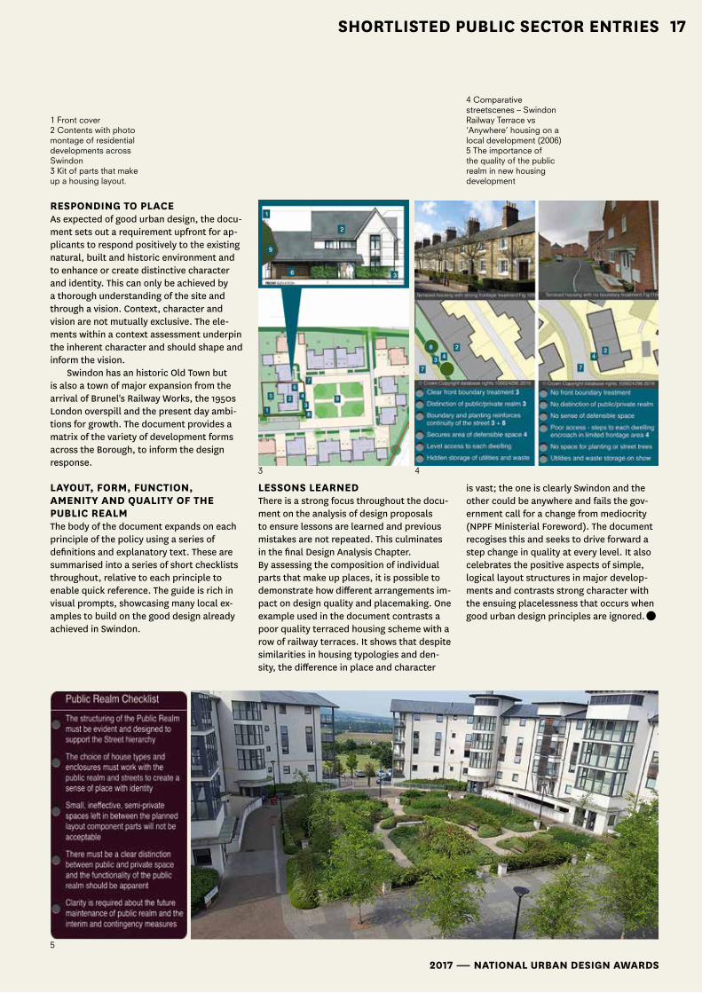
1 Front cover2 Contents with photo montage of residential developments across Swindon3 Kit of parts that make up a housing layout.
3 4
5
4 Comparative streetscenes – Swindon Railway Terrace vs ‘Anywhere’ housing on a local development (2006)5 The importance of the quality of the public realm in new housing development

national Urban Design awarDs ― shortlisteD entries 2017
1818 sHoRtLIsteD stUDent entRIes
Charlton Riverside is a 49 ha site that is part of London’s industrial land. Predominantly used for warehousing, industrial uses, wholesale retailing and car parking this urban makeup presented a barren environ-ment of impermeable and underused spaces which discouraged everyday activity and diversity.
However, Charlton Riverside has been recently identified as an Opportunity Area as per Greenwich Council’s Supplementary Planning Document; significant residential and commercial mixed use development is planned following the repeal of Riverside Wharf’s safeguarded status and Strategic In-dustrial Location designation.
With this serving as the premise, the project was to develop a masterplan pro-posal that would transform the area into an attractive, vibrant and distinctive place for its users and residents.
VIsIonUrban design and regeneration projects in the capital tend to take a negative ap-proach to the manufacturing industry, often forgetting that it can be highly innovative and creative as well as critical to economic diversity.
Charlton Riverside masterplanA 21st Century Industrious Urban Place for London by Brian Yuen, Douglas Lee, Cassie Tang and Wilson Wong
1
We believe that existing industries at Charlton Riverside like Stone Foundries – a world class UK producer of castings for the aerospace and defence industries – should be celebrated as we transform the area into a new 21st century industrious urban place. Specifically, we aimed to retain and refur-bish underused/dilapidated warehouses and industrial buildings to create attractive, adaptable buildings for industries in key growth sectors like: digital, advanced manu-facturing and engineering (AME), creative and low carbon.
These buildings will then be incorpo-rated into a wider self-sufficient plan that aims to distinguish Charlton Riverside as a manufacturing hub, as well as complement key economic and cultural functions neigh-bouring Charlton Riverside e.g. Silvertown, O2 Arena, London ExCel Centre, London City Airport and the Crystal.
AIms AnD oBJeCtIVes• Enhance the industrial character• Promote AME industries• Encourage a diverse range of communities
and a mix of uses• Increase public transport connectivity• Improve the public realm, encouraging
pedestrian oriented open spaces• Promote sustainable forms of travel par-ticularly walking and cycling.
URBAn DesIgn PRInCIPLes• employment Activity Clusters Develop activity clusters around a central
focal point to create distinct character ar-eas around the site to spread pedestrian footfall.• Permeable Urban network
Create a porous and permeable urban route network that encourages more lateral and vertical movement to connect all areas of the site.• Adaptable Warehouses
Refurbish and reuse warehouses and factories to create unique workspaces for key growth industries in creative, digital, AME and low carbon sectors. Encourage flexible and creative architectural facade designs to integrate with local residential neighbourhoods. • Permeable, Walkable Public Realm
Promote organic landscaping and urban design to boost ecology and create aes-thetically pleasing public realm.• Vibrant Waterfront
Increase permeability and access to
nAtIonAL URBAn DesIgn AWARDs ― 2017

shortlisted entries 2017 ― national Urban design awards
19
Bloomsbury in London, Mohri Gardens in To-kyo, Xintiandi in Shanghai.
Using our research, a street hierarchy was developed to ensure streets were well proportioned for pedestrians, cyclists and vehicles alike. Where possible, perimeter block structures were created to infill vacant spaces to ensure active frontages could face the street and generate footfall. By develop-ing the urban makeup in this way, the site's character could be reconstructed in a more organic fashion allowing more interesting streets patterns to be formed.
Key Lessons LeARneDThis project aimed to illustrate the possibili-ties of integrating manufacturing into 21st century city planning and regeneration, by bringing together industry, communities and businesses to create a manufactur-ing heart at Charlton Riverside. However, implementing this concept was not without its challenges:• The creation of a manufacturing location
19sHoRtLIsteD stUDent entRIes
2017 ― nAtIonAL URBAn DesIgn AWARDs
1 Site context2 Masterplan proposal3 Artist’s impression of waterfront
2
3
the waterfront to improve vibrancy and enhance walking and cycling routes along the river trail.• Active frontages
Encourage active edges that generate footfall and different uses of space at different times of the day to promote a diversity of activities.
DesIgn PRoCess To develop our urban grain our team un-dertook a thorough site visit to analyse and determine which building structures had the potential to be converted into adaptable workspaces that could fit within a more con-temporary urban fabric. We also decided to embrace the larger built forms and to make the Stone Foundries building and a new cen-tral park our manufacturing heart [2].
From this, we developed a layout of seven distinct activity clusters [1-7] based on the site’s inherent characteristics. Along the prime waterfront area, we located the tourism [1] and residential clusters [7a][7b] whilst the community cluster [5] was located near to the accessible central park. Employment clusters [3][4] were then lo-cated around the central park to integrate manufacturing sectors with emerging growth industries and residential areas with the employment sectors. The Boutique and Of-fice cluster [6] was designated along the main road to form an active frontage and attract users outside the area into Charlton Riverside.
Once a conceptual layout was created the vacant spaces were filled with new de-velopment structures. To help understand ideal densities, massing and street widths that maintained human scale and effective functionality, the team researched the urban fabric of different areas like Shoreditch and
presents regional transport and traffic problems • Manufacturing buildings are fitted with specialist equipment that are not adapt-able for alternative uses• Manufacturing plots are often imperme-able and not pedestrian friendly; adapting these for mixed use urban living was a challenge but through a creative design process a unique and liveable neighbour-hood can be formed •
Brian Yuen, Douglas Lee, Cassie Tang and Wilson Wong, a group exercise from the Bartlett School of Planning UCL

national Urban Design awarDs ― shortlisteD entries 2017
2020 sHoRtLIsteD stUDent entRIes
nAtIonAL URBAn DesIgn AWARDs ― 2017
gLAsgoW CIty CentRe LAnesFrom the medieval city origins around Glas-gow Cross, spreading westwards across the Victorian gridiron city plan to Blythswood Hill, there are over 100 lanes in Glasgow’s city centre. Predominantly used for service access, bin storage and homeless sleep-ing, this under-utilised secondary network exists in parallel to Glasgow’s congested city streets – a city within a city. In 2016 Glasgow City Council commissioned a Lane Strategy for Glasgow City Centre, to transform the lanes ‘to attract more people to come to Glasgow and enjoy spending time in the city centre’.
Alongside this initiative the University of Strathclyde Urban Design Unit undertook the Future Cities: a ‘city within the city’ – Living lanes project, to investigate the collective potential of the lanes. The lane network was mapped, observed, recorded, and analysed by interconnected groups, in relation to: History, Centrality, Uses, Character and Per-ception. The result was an extensive record of the existing condition of the lanes, which charted the issues, uniqueness and poten-tial of the lanes. From these findings the Key Criteria for Lane Transformation were developed.
LAne CLUsteRsA significant finding was the correlation between a lane’s physical attributes (size, orientation and location), the city’s histori-cal development and the key use within the city districts. This finding resulted in three distinct clusters of lane types to be identi-fied. A bespoke strategy for each cluster was then developed to reflect the unique condition, character and needs of each lanes group, including the connecting street and surrounding context.
Merchant City – Wynds & CourtyardsBuchanan Street – Lanes & CourtsBlythswood – Serial Gridiron Alleys
meRCHAnt QUARteRThe masterplan project Merchant Quarter was born out of the Merchant City Cluster Strategy. The area, centred on Glasgow Cross and the Trongate, is home not only to the oldest lanes in the city – the wynds, vennels and closes – but also large swathes of vacant post-industrial land. In the 19th century a vibrant community was formed around these small medieval streets that linked the back courts with the Trongate and the River Clyde. However the advent of the railways later in the century resulted in a web of rail tracks slicing through the existing urban fabric and obliterating this neighbourhood.
Today, after the railway abandoned the area in the 1970s, surface car parks dominate, high level tracks and buildings awkwardly terminate, and railway arches lie vacant. The extent of fragmentation is so great that a full masterplan project was deemed necessary to a) achieve the level of urban repair required to support a vibrant lane network, b) fully explore the potential of lanes in urban regeneration, and c) revi-talise the existing lanes.
The vision is to create a new urban grain based on the historic figure ground by transforming car-dominated streets into pe-destrian priority shared spaces; converting
vast carparks into mixed use communities, re-linking the city centre with the river; and re-utilising the derelict railway structures, that so destroyed this area, as part of the solution in its regeneration.
The significant issues for transform-ing a large under-populated post-industrial site into a vibrant new neighbourhood have been addressed by proposing appropriate high density/mixed accommodation. This proposal can support the expanding crea-tive industries and existing community while providing local diversity and a range of local and global services. Plot sizes, based on lo-cal tested models, can offer versatility for both multiple use and future adaption.
Commercial and retail units have been designed to support growth by providing both live/work and small retail units for start–ups as well as larger office buildings. A new fresh food market is proposed for the neighbourhood, building on the Glasgow’s established but fading market tradition, as well as an art gallery and studios under the disused railway arches to provide a major civic attraction.
New streets and lanes have been de-signed as people-orientated spaces with densities, building heights and road de-sign to create an optimum environment for both access and enjoyment. This is contin-ued with the retrofitting of existing streets with green verges, cycle lanes and widened pavements.
LAne tyPoLogIesFour new lane typologies form the main structure to the new masterplan:1. Historic2. Mixed Use3. Green Alley 4. Service
The new lanes connect with the surrounding lanes, Old and New Wynds and Goosedubs, Merchant and Shipbank Lanes. These rem-nants of the medieval lane network shall be
Lanes you’ll LoveA Masterplan for Glasgow’s Merchant Quarter by Jo White
1
2

shortlisted entries 2017 ― national Urban design awards
2121sHoRtLIsteD stUDent entRIes
2017 ― nAtIonAL URBAn DesIgn AWARDs
transformed as per the Key Criteria for Lane Transformation and rewoven into the new urban fabric.
Each lane design, new and old, address-es the perceived and real issues of tight knit development – privacy, safety, noise and light. Solutions include double-sided blocks to buffer noise from commercial proper-ties, secure access, leisure spaces, shared surfaces for service access and pedestrians, and will incorporate soft edges between buildings and the public realm – for seating, displays and planting – to support greater interaction and personalisation.
Lessons LeARneDRecreating a close-knit historical fig-ure ground with the flexibility of modern high-density city plots was challenging. Consolidating the commercial and devel-opment demands with my aspirations for an urban village structured around lanes required careful consideration of building use, typology, and public realm interface. However, I feel the resulting masterplan and proposed series of new lanes demonstrates that it is possible to structure a large-scale city development around a people-centred infrastructure and deliver a truly mixed use development to recreate the vibrancy and character of the historical city.•
Jo White, University of Strathclyde
1 Lane Clusters2 Key Criteria for Lane Transformation3 Merchant Quarter Masterplan4 New Lanes – Historic (Merchant Lane), Mixed Use (New Lane) and Green Alley
3
4

national Urban Design awarDs ― shortlisteD entries 2017
2222 sHoRtLIsteD stUDent entRIes
nAtIonAL URBAn DesIgn AWARDs ― 2017
The project engages with tackling a wide spectrum of criteria, including micro-cli-mate, socio-economic conditions, planning policy, environmental conditions, greywater recycling solutions, and lack of city-wide open space. The scheme is set in the district of Votanikos, in the west of Athens, Greece; a location where a residential and mixed use community meets a declining industrial area. The border condition at this location is of severe disuse and dereliction, while a train line cuts the area off from the main city districts, impacting negatively on the local community. The scheme aims to intervene locally and city-wide through a strategic greywater recycling system and urban de-sign framework, designed to build upon the existing urban structure and develop a new typology.
The site is located centrally along the in-dustrial border; a 3km stretch between large open spaces; the ancient Plato Academy in the north and a disused military camp in the south. In-between is a third large open space; the Agricultural University, and largely derelict or declining industrial land. The local government set up a Presidential Decree 1049/D/20-09-95 to reduce pollution in the city and aim to convert the industrial land back to greenscape. The policy rejects redevelopment of any industrial plot, lower-ing commercial value and creating viability
to convert the land. These elements set the potential framework for a landscape inter-vention, by forming a series of open spaces that can be connected together to form a large city landscape. In a series of phases over a period of around 40 years, a new landscape and urban block framework is to be carved out of the industrial area and Vo-tanikos residential area, to reset the border condition to the local area and city.
mICRoCLImAteA main object is to aid in adjusting Athens’ micro-climate. In summer, temperatures reach 40°C, caused in part by a lack of open space, and also the low density and concrete thermal mass of the industrial area. Cool air is prevented from flowing and cooling the city, while the thermal mass releases heat at night, resulting in the city being caught in a condition of urban heating. Studies have found that landscapes in cities contribute to natural cooling via evapotranspiration; the total landscaped area of the interven-tion totals 100ha, which can allow cool air to flow and penetrate up to 2km; deep into the city centre.
A large driver of the project is the in-troduction of a greywater recycling system. Within the existing and proposed land-scapes, water towers are to be constructed throughout to provide greywater as an
irrigation strategy for the land. Water is to be stored in tanks underground, and pumped up into the water tower tanks dur-ing the day using solar power. At night water is released from the tanks to irrigate the land. As part of the phasing of the project, a swimming baths is proposed as an extension to the central water tower, providing a key civic building to the area. The water cleaning reedbeds form a distinctive characteristic throughout the sites; they follow the con-tours of the land, allowing the water to flow and be cleaned unaided by a power source. The water towers also act as nodes through the site, serving as navigational guidance for pedestrian and cycling routes.
BLoCKsTogether with the landscape intervention and water towers form a significant aspect to the project. The third main element is the urban blocks. They are to be designed around greywater recycling, which forms part of a larger system with the landscape. Building on the existing typology in Ath-ens, the Polikatoikia, they take forward the merits of the typology, while learning from issues. The Polikatoikia system introduced a greater density to the city, by developing the original courtyard houses into apart-ment buildings. These allowed plot owners, building groups and developers to redevelop
Athens: Landscape CityAn Urban Design Framework for open land, micro-climate cooling and greywater recycling by Lucy Fineberg
1

shortlisted entries 2017 ― national Urban design awards
2323sHoRtLIsteD stUDent entRIes
plots to introduce a mix of uses and be able to house extended families on a single plot. The typology adapted well to technological advances, such as the introduction of motor-ised transportation; stepping back at street level to provide pedestrian access. However, courtyards are fragmented pieces of private land; corner plots are often unobtainable for development as they tend to be land-locked by adjacent buildings. In general, the relatively small urban blocks tend to be overdeveloped. The new typology aims to tackle these issues. A minimum maxi-mum framework is set out to form urban blocks with large enough courtyard spaces and internal courtyard development where appropriate. The heights of blocks and step-ping back at upper levels remain as before, while densities remain constant (at around 200 persons per ha) due to the small shifts in strategy. A fine urban grain is encouraged with double aspect living, and a mix of uses is to be incorporated into the blocks.
fRAmeWoRK The framework designs in elements to create the unfolding vista, by incorporat-ing tolerances, setbacks to create squares, and special building typologies. Courtyards are partially communal, partially private to provide green space throughout the scheme that is communally responsible. In addition, the urban blocks are to act as water tow-ers; collecting, storing and releasing water. Water is readily available for use through ki-netic energy saving both energy and potable water for uses such as flushing toilets.
PHAsIngThe phasing of the project follows the der-eliction of sites. Empty sites are to be rede-veloped first, progressing as each plot falls into dereliction, until a final small number of strategically selected plots are compulsorily purchased ordered to complete the scheme. A process of decontamination for each site is undertaken with strategic planting such as fireweed used to create visual green spaces. The phased programme of decontamina-tion, conversion, construction, and planting is planned for a period of around 40 years; looking for a holistic long term solution to present problem.•
Lucy Fineberg, University of East London
1 Site proposal2 Scheme framework possible layout3 Site location4–5 Heat map before and after of Athens with the industrial area outlined after the proposed intervention showing significant cooling to the site and impact beyond
2017 ― nAtIonAL URBAn DesIgn AWARDs
3
4 5
2
6
6 View through proposed site out towards the landscape, water tower and civic building

national Urban Design awarDs ― 2017
24 sHoRtLIsteD BooKs
Human Ecology – How Nature and Culture Shape our World
Frederick Steiner, 2016, Island Press, Washington DC, ISBN 978-16091-783-4
‘Humans have always been influenced by nature’ tacitly suggests we are not fully part of nature. Human Ecology makes the case for the need to explore how to (re-) assert humans’ relationship with nature, and stud-ies the relationship between humans and the environment, drawing from a diverse range of disciplines including biology, geography, sociology, engineering and architecture. Here Steiner shows how human cultures have been shaped by natural forces, and how this understanding can contribute to both humans and nature thriving, and address societal challenges involving ecology and culture; nature and humans; and, land and people.
Posing important questions, often from small scale observations but with large scale significance, and offering principles and in-formation to form insights and vision, the book is structured across eight chapters organised hierarchically from small to large scale: fundamental principles of human ecol-ogy; habitat; community; landscape; the ecological region; nation, state and nation-state; the green chaos of the planet; and, following nature’s lead. Whilst there are notes, bibliography and index, photos would have helped visualise examples of key obser-vations and assertions.
This new ecology emerges out of a rec-ognition that people engage in hierarchical ecological relationships and the nature of those exchanges can be studied in the urban and suburban environments where they oc-cur. Concepts of resilience and regeneration cover ideas around an area sustaining itself by resisting damage, restoring and renewing sources of energy and materials, and miti-gating and adapting to the consequences of climate change. It is a return to the notion
of ‘community as a central building block of humanity’, one where resources of all types are maintained.
In the wider context, it highlights that if we continue only to focus on human is-sues of large urbanised areas, with the world population nudging 7,500 million, there are over 3,500 million people living in more rural areas whose situation is also important but less well understood. Consideration of these contexts in a more integrated manner could lead to a wider variety of ways to address the issues that we all face, in whatever type of living environment.
Accepting the world as a never ending system of interactions highlights the neces-sity to acknowledge the full implications of these interactions, including with other species and generations. But this is some-thing we tend to ignore as it ‘endangers the assumptions and practices accepted by modern societies’; ecology and economics have the same Greek root. Whilst we con-tinue to focus on our differences rather than our similarities, we are destroying ourselves and much of the life on the planet along with us.•
Marc Furnival, urban designer and architect. Director of Iberia North, a property, design and construction agency based in Asturias, Northern Spain
Zoning Rules! The Economics of Land Use Regulation
William A. Fischel, 2015, Lincoln Institute of Land Policy, ISBN 978-1-55844-288-7
Zoning Rules! provides a dense but highly readable introduction to land use regulation in the United States for non-economists, non-planners and even those, like this reviewer, who have little prior knowledge of American land use control. However, the book is more than an introduction, and
provides closely argued insight into multiple facets and stakeholder positions in American land use regulation over the past century.
Drawing on a long career in studying, teaching and simply being intrepid in seeking out explanations for observed phenomena in land use regulation, Fischel presents many inter-connected stories that show what zon-ing in the US is all about. Starting with some digestible foundations to topics such as land use and land economics generally (Chap-ter 1) and the legal structure and judicial supervision as the context for zoning activ-ity (Chapters 2 and 3). Fischel sets out the position, in Chapter 4, that land use regula-tion can become the mechanism by which property tax can be effectively wielded as a ‘fee’ for public services. This is only possible due to the structure of US local government. Local governments mostly have considerable control over their tax raising and spending, which therefore make voter decisions sensi-tive to how tax is raised and how tax monies are spent on their local services. Chapter 5 presents a non-mainstream economic history of zoning, where its popularity is not the re-sult of top down or progressive innovation by a few individuals, but as being driven, bot-tom-up, homeowners protecting the value of their property. Chapter 6 demonstrates how some economists’ tools can fruitfully be used to analyse zoning disputes. Chapters 7 and 8 address zoning in suburban and metropoli-tan development patterns, in particular, the pattern in suburbs of the shift from zoning as ‘accommodating development in an orderly fashion’, or ‘good housekeeping’ in the 1950s, to zoning as ‘growth control’ starting in the 1970s. The final Chapter provides remedies for what the author calls ‘excess regulations’.
The title of the last chapter should not, however, lead us to conclude, therefore, that Fischel’s position is simply a free market ad-vocate, as he has been labelled elsewhere. He himself argues: ‘The laity should be skep-tical of those who offer unambiguous advice’ (p367). This attitude is reflected in the ‘on the one hand, on the other hand’ arguments he presents on the many issues and cases in the book. The relevance to urban designers in a non-US context may be in the dynamics

2017 ― nAtIonAL URBAn DesIgn AWARDs
of bargaining in property disputes, and in the insights into how economists think about de-velopment, growth and urban form.
Zoning Rules! is not an easy read, but, with its serious but balanced, if primarily economic, analysis told through a flow of witty illustrative cases – one section is en-titled “‘Garden Cities of Tomorrow’ Would Work if Tomorrow were 1905” – it is an ul-timately rewarding foray into the world of American land use planning.•
Louie Sieh, urbanist, educator and researcher
Concurrent Urbanities, Designing Infrastructures of Inclusion
Ed. Miodrag Mitrasinovic, 2015, Routledge, New York and London, ISBN 978-113881-023-5
This collection of essays by scholars, practitioners, architects and activists was developed from three public events at the Parsons School of Design in New York City in 2008, 2011 and 2013. As a consequence, it has the character of a conversation that has been honed over time with the individual contributors expanding on different elements of the debate. The scene is set by the editor with an account of Mayor Bloomberg’s New York where by the end of his time in office in 2014, the top 1 per cent of the population commanded 30 per cent of the city’s income. As well as the inequities thrown up by the Bloomberg Mayoralty the authors engage with effects of the post-socialist free-for-all in Yugoslavia and with left over, left behind, peripheral and contested spaces in European and American cities.
In this context the essays make a col-lective critique of the way neo-liberal economics has driven city form to follow ‘fiction, finance and fear’, disenfranchis-ing citizens and hyper-commodifying public space and housing in the process. They argue for a fundamental cultural shift
from calibrating urban experience through consumption, to engaging with social pro-duction as the driver for more sustainable change. As a group, they have developed dif-ferent ways of practicing to enable them to invent new modus operandi. Some practice as collectives such as The Hester Street Col-laborative, Amplify, or the Centre for Urban Pedagogy. And some ‘scholar practitioners’ use their academic institutions as a base to experiment with working with communities in different ways, often bringing the ability to patiently document and nurture evolv-ing community-led processes. They argue for ‘people’s right to determine their own meaning’ which, in a sense, extends to them-selves and their right to determine meaning through their practice.
The essays describe how different groups of people organise themselves and gather skills envisioning increasingly ambitious spaces, whether these are a skate park un-der a freeway, or a recreational route linking for the first time a community to its water-front. The urbanities are concurrent because their value occurs in locating where ‘bottom up and top down forces collide’. For exam-ple after Hurricane Katrina, the authorities in New Orleans proposed clearing suburban homes to increase wetland areas. Deborah Gans supported householders to negotiate this conflict, designing a landscape that in-cluded both the homes and wetlands.
Many of the essays cover a time frame that spans the millennium and is bookended by two global recessions, with the prac-tices developing their work both despite and because of these economic conditions. As a prompt to reflection on practice and/or policymaking it is rewarding to read and is refreshingly challenging without being obscure or formulaic. It makes a convincing case for the value of research-based practice to inclusive city making.•
Juliet Bidgood, architect/urbanist
The Urban Climatic Map: A Methodology for Sustainable Urban Planning
Ed. Edward Ng and Chao Ren, 2015, Routledge, New York and London, ISBN 978-1-84971-376-4
The impacts of urbanisation on climate are now generally widely understood and treated as a matter of concern by most. Character-istics such the ‘urban heat island’ effect, in which the air temperature of our cities is consistently higher than that of surrounding rural landscapes, are measurable and their impacts have been extensively document-ed. These are not abstract and academic concepts: manmade climate change has profound implications for sea levels and flooding, for wildlife species and agriculture, for health and wellbeing. Generally, it is the least economically advantaged in society who are least able to mitigate these impacts and who suffer the most.
In this context, The Urban Climatic Map is an important book that systematically addresses a critically important subject of international relevance. Aimed at a specialist audience of climatologists, it is a challenging technical read for other built environment professionals and is not intended for a lay audience. It is an academic textbook, ed-ited by Prof Edward Ng and Chao Ren of the Chinese University of Hong Kong, and brings together papers from dozens of contributors across a well organised series of 34 chap-ters. The inputs have come from a range of academics and climate experts located in universities and research institutions around the world. Prof Ng is a highly regarded expert within his field who has been widely pub-lished (I reviewed his book Designing High Density Cities in Urban Design issue 116).
The opening section introduces key con-cepts and ideas, while subsequent sections address case studies in large, medium-sized and small cities or settlements. The final section of the book explores forthcoming
25sHoRtLIsteD BooKs

national Urban Design awarDs ― 2017
26 sHoRtLIsteD BooKs
developments within the field, particularly those that follow advances in computational power and algorithmic complexity, looking at the potential applicability of the research to inform thinking about urban change at a series of scales. These last chapters are the most interesting and relevant to a non-spe-cialist audience. They address the concern that one might otherwise have of academic discourse of narrow relevance. It is particu-larly encouraging that the final chapters identify the scales of strategic planning and spatial design activity and the varying forms of intervention that can follow from consideration of climatic effects. The interre-lationships between built form, topography, air flow and temperature are intuitive in gen-eral but can now be assessed with scientific rigour and can inform the transformations that are underway in cities and settlements around the world.
The Urban Climatic Map is without apol-ogy an academic textbook, and follows the conventions of formatting, citation and referencing. For those studying or practic-ing within the field it will be an important resource and connection to the work of others. It is a shame, as tends to be the case in academic publishing, that illustra-tions are limited to black and white plates, when full colour would make the informa-tion more legible and engaging. Unlike Prof Ng’s previous book, the relationships to other built environment disciplines, and to a globally diverse set of locations, are clearly understood. The book is stronger for these connections in scale, discipline and context, and for those within its field is to be recom-mended. •
Jonathan Kendall, partner and director of urban design at Fletcher Priest Architects and senior teaching fellow at the Bartlett School of Architecture where he leads the Making Cities programme
Housing Cairo: The Informal Response
Ed. Marc Angelil and Charlotte Malterre-Barthes in collaboration with Something fantastic and CLUSTER, 2016, Ruby Press, Berlin,
ISBN 978-3-944074-02-3
Delivering housing, particularly affordable housing, is a critical topic that we all need to address in a constantly urbanising and pop-ulation-growing world. Delivering affordable housing theme is of a great concern to many governments, urban professionals as well as the population at large. This is particu-larly critical in large, urban and fast growing agglomerations such as Cairo, Mexico City, Rio or Mumbai that are reaching well above 20 million people and are characteristic of both formal and informal urban production processes. It is therefore important that the scholars and practitioners of urbanism begin to understand these processes and forms of housing production in order to be able to find solutions for making better places in these regions.
Housing Cairo provides an interest-ing perspective on the housing crisis and solutions in Egypt by first introducing a perspective on what are formal and infor-mal processes of housing production and delivery. Through the background of the national and local politics of urbanism in Egypt the authors explain how various deci-sions made during different political regimes impacted on the spatial and urban charac-ter of Cairo. They then show what works and what doesn’t through detailed explorations of case studies. This is well illustrated and explained through the discussion of the state of the so-called ‘desert cities’, planned and built as a group of new towns, resembling housing schemes in Paris or London, that are devoid of the variety of employment or other uses, and as a result, only attract upper classes and remain lifeless and half-empty. In contrast, urban areas developed through the so-called informal processes by plot
subdivisions of the city’s rural edge, employ-ing small-scale builders who learned their craft in Dubai and other Gulf countries, pro-vide the necessary and affordable houses, but frequently lack infrastructure provision, and are built without the necessary permits. However, these areas benefit from the in-formal economy of street vendors, and over time evolve new building types that incorpo-rate retail, offices and other uses.
Through an interesting case study of Ard el Lewa, an informally built neighbourhood, the reader is introduced to many creative so-lutions developed by local families. Through trial and error, as well as employing local knowledge of the construction techniques, it becomes obvious that what is formal (as in desert cities) and what is informal (as in Ard el Lewa) are two binary opposites, not clear-ly defined; they both have advantages and disadvantages, and are complementary in delivering Cairo’s housing. The authors warn us that we need to understand the processes of these types of production with a critical eye and not idealise these forms of neo-vernacular, new urban aesthetics or pop-up urban solutions, as seen in some other large cities. Urban design and architectural educa-tion should embrace this type of urbanism, in order to be able to find appropriate solu-tions when upgrading existing schemes or designing new urban extensions.
The book is nicely produced, support-ed by photographs, analytical drawings and diagrams. It is the result of the work of the academics and students of the Mas-ters of Advanced Studies in Urban Design Programme at ETH Zurich, supported by Something Fantastic and CLUSTER groups. The book will be useful to both academics and practising urban designers and other professionals.•
Georgia Butina Watson, Professor and Research Director of Urban Design, School of the Built Environment, Oxford Brookes University

2017 ― nAtIonAL URBAn DesIgn AWARDs
Infratecture, Infrastructure by Design
Marc Verheijen, 2015, nai010 Publishers, ISBN 978-946208-240-3
As a traffic engineer/architect Marc Verheijen brings his experience of working for the City of Rotterdam, with OMA and as Infrastruc-ture Professor at Rotterdam University of Applied Sciences, to this ‘worm’s eye’ view of infrastructure design. The book is introduced by a short history of infrastructure emphasis-ing the enduring influence of street patterns, the sometimes powerful iconography of in-frastructure form and the ability to redefine place with projects such as the Chanel Tun-nel. Verheijen observes that infrastructure today is unfolding in a different context to that which made roads, canals and railways, being made instead in a networked, social world, in the wider flows of movement and culture.
The author sets out an ‘attitude’, an ‘infratecture’ polemic. To design infrastruc-ture, we should understand these wider networks and links, and set new elements in their cultural and social context. We should understand infrastructure as a public space that belongs to everyone and consider the need to balance functionality and ambi-ence. Importantly he gives emphasis to the role of infrastructure to communicate an in-stant ‘users-manual’, whilst creating spaces that are innovative and transcend functional norms.
The book is organised in 15 themes such as bridging, re-use, speedscapes, streets, etc., each illustrated by two case stud-ies. There are some astute observations in the preamble to each pair of case studies that could be useful for someone develop-ing briefs for infrastructure projects. For example, the idea of transit spaces being populated by walkers moving at two speeds. Case studies include ‘mobility cathedrals’ like Grand Central Station, and carved out semi-subterranean spaces like Les Halles, Paris or Hauptbahnhof, Berlin, spaces that are traversed by 1/10th of the city population
every day. They also include roads designed as ecosystems, boulevards, station cy-cle parks and reused infrastructures. Much weight is given to written descriptions, when more images and scaled plans and sections could have helped to extend an understand-ing of the scale and spatial complexity of the cases and the spatial strategies that are discussed.
At times the book seems to lack critical reflection on the way that transit spaces can relentlessly exploit their mobile audiences targeting ‘run shopping’ by filling empty space with retail offer. It is the more various juxtapositions of function and use that are interesting. Early on the author notes that the Rijksmuseum has a room at Schiphol air-port. His own design for a steel enamel-clad, curvilinear underpass is available over the year on a 4:2 ratio for wrapping with adver-tising or culture.
The author asserts that infrastructure should make travellers feel human, offer gateways to place and frame a mobile cin-ematic identity. Designers need to enjoy ‘the common and mundane aspect, the generic and general side of it’ as well as find the spe-cific ‘couleur locale’, the mobility culture of places as a foundation for their design.•
Juliet Bidgood, architect/urbanist
Landscape as Urbanism: A General Theory
Charles Waldheim, 2016, Princeton University Press, ISBN 978-0-691-16790-9
Landscape as Urbanism is a timely and fasci-nating book. It seeks to describe and situate contemporary practice and theory that redefines disciplinary boundaries in relation to the city at multiple scales larger than the architectural. The book, written by a profes-sor and chair of landscape architecture at Harvard’s Graduate School of Design, has a particular focus on avant-garde projects and protagonists whose work has developed over the past couple of decades. In doing so, the book expands into a wider and more holistic exploration of the role of landscape in urban thinking over many centuries.
As a consequence, Landscape as Ur-banism provides a compelling overview of internationally-recognised urbanists, landscape architects and architects whose practices share a common underpinning in their relationship to nature and ecologi-cal systems in the broadest sense. The book establishes a chain of relationships between current practice, the 20th century (Fordist and Post-Fordist) city and deeper origins in earlier developments of landscape archi-tecture as a distinctive discipline. This is dated back to conceptions of landscape and nature in Renaissance thinking and engages with particularly pressing contemporary is-sues such as the simultaneous conditions of explosive East Asian urban growth and the managed decline of once-thriving Detroit.
A number of recent and contemporary forces are tied into the conceptual frame-work, including the multi-scalar implications of containerisation, airport landscapes and industrialisation across a series of thematic chapters. Names from the early Modern Movement, such as Ludwig Hilberseimer and Frank Lloyd Wright, are reappraised and as-sessed for their contribution to an emerging body of activity that links current designers
27sHoRtLIsteD BooKs

national Urban Design awarDs ― 2017
28 sHoRtLIsteD BooKs
and practices including Adriaan Geuze (West 8), Rem Koolhaas (OMA) and Bernard Ts-chumi. Linking their practice to that of their disciplinary predecessors, the role of Fred-erick Law Olmsted in shaping the landscape and city form of nineteenth century New York is brought into a broad narrative that posits a design priority of ‘ground’ over ‘figure’. For those involved in academia alongside prac-tice, the book raises interesting pedagogical questions regarding disciplinary definition and professional education, identifying a growing movement that can be classified as ‘landscape urbanism’ taught at the in-tersections of architecture, urban design, ecological sciences and landscape design.
Fascinating as it is, this is also a chal-lenging book written in dense prose for an advanced academic reader. The language at time veers into impenetrability; it requires high levels of concentration and care-ful reading. But the effort is worthwhile. It establishes an intellectual framework that explores the boundaries between disciplines that are at the heart of the questions and challenges of current urban theories and practices. It does have a focus on the avant-garde and more discussion could perhaps follow about the relationship between elite activity and global dissemination of forms and ideas in a highly connected academic and design culture. Graphically the book is very well designed and styled, with copi-ous reference images throughout that fully support the argument. Referencing is thor-ough and rigorous but is subservient to the primary narrative rather than dominant and distracting in the way that undermines too many academic texts. The book is a heavy read, but fully worth the effort.•
Jonathan Kendall
Sharing Cities – A Case for Truly Smart and Sustainable Cities
Duncan McLaren and Julian Agyeman, 2015, MIT Press, Cambridge, Massachusetts, ISBN 978-0-262-02972-8
The notion of sharing is something we encourage in our children even though it is antithetical to the leisure shopping, celebrity reverence, money-worshipping society in which we live. Recent incarnations of the term sharing are here argued to have been subtended too narrowly. McLaren and Agye-man make the case for implementing a wider and deeper social, cultural, economic and political understanding to overcome the ap-parent shortcomings of the more disjointed and commercial notion of sharing that we increasingly encounter: ‘consumerism dis-courages trust and empathy’.
The sharing idea outlined in the intro-duction is fleshed out with actual examples throughout the case studies, such as com-munal food growing, library parks providing internet access or local venues to swap toys. Detailed case studies of San Francisco, Seoul, Copenhagen, Medellín, Amster-dam, and Bengaluru (formerly Bangalore) contextualise the authors’ discussions of: collaborative consumption and production; the shared public realm, both physical and virtual; the design of sharing to enhance equity and justice; and, the prospects for scaling up the sharing paradigm through city governance. They show how sharing could shift values and norms, enable civic engage-ment and political activism, and rebuild a shared urban commons. Whilst there are detailed notes, bibliography and index and a few explanatory diagrams, there are no pho-tos, which would have helped visualise the refreshing mix of case study places.
This wider notion of sharing could be of things, services, activities or experiences, and could be material, virtual, tangible or intangible. This wider definition would then
enable us to properly acknowledge some of the challenges often sidelined in any mean-ingful sense such as, one thousand million people living in extreme poverty, rising income inequality, and lack of genuinely af-fordable housing; and from an environmental perspective, resource scarcity, biodiversity loss and climate change.
This acknowledgement highlights the extent to which humans are living outside the parameters of an environmentally safe, socially inclusive and sustainable, operat-ing space. These parameters are set with a social foundation as an inner boundary and environmental ceiling forming the outer. Hu-man deprivation sits below the inner and environmental degradation beyond the out-er, of this doughnut shaped envelope. This questions the framing of capitalism as our only viable model, that commercially orien-tated ‘solutions’ are our only tool to address social issues. What should not be dismissed are the ‘symbolic, intangible and ideation-al aspects of culture that underpin beliefs, values, norms and desires’, all of which help to shape and define the wide variety of iden-tities that make the world the interesting place it is. This, of course, is just the hu-mans, flora and fauna notwithstanding. The planet is our ultimate shared space.•
Marc Furnival

29
2017 ― nAtIonAL URBAn DesIgn AWARDs
JUDgIng PRoCess exPLAIneD
Since their foundation in 2007 the Urban Design Group’s (UDG) National Urban Design Awards have considered over 450 submis-sions for its five Award categories, highlight-ing some of the outstanding and innovative urban design work being undertaken throughout the UK and beyond, from finished schemes to design guidance and publish-ing. Initially set up under the guidance of their founder John Billingham, the National Urban Design Awards are different to other award schemes as the winners are chosen by professionals working in urban design. The Awards ceremony in the spring of each year has gone from strength to strength, becom-ing a major highlight of the urban design calendar.
The Awards are run by a small committee of Award convenors who are responsible for setting the criteria and submission guide-lines for the five Award categories: • Practice Project Award• Public Sector Award• Student Award• Book Award; and • Lifetime Achievement Award.
A close partnership has been created from inception with the charity Francis Tibbalds Trust, which funds prizes for the £600 Stu-dent Award and the £1,000 Practice Project Award. The Trust aims to promote excellence and good practice in urban design by award-ing prizes, offering sponsorship and other similar activities. Janet Tibbalds, widow of the late Francis Tibbalds and Chair of the Trust, awards prizes to the winners each year with her family.
tHe CRIteRIATo attract high quality submissions, the Awards committee focuses on developing judging criteria that satisfy two main objec-tives. The first objective is that submissions have to be of high urban design quality clearly demonstrating great aspirations and leadership, and following a rigorous process from identifying urban design objectives, undertaking a context-specific site analy-sis, and the conceptual development of the design through to delivery of the project. The Awards committee places particular empha-sis on the reflective design process with cri-teria that highlight the contribution to urban design practice and the lessons learned. The second objective is how well communi-cated the entry is. Shortlisted entries have previously been published in the quarterly Urban Design journal, and so the clarity of writing style and good quality images have become important differentiators in the shortlisting process.
tHe PRoCessOnce entries are initially submitted, a judg-ing panel comprising one of the joint editors of Urban Design in the chair, an academic from an urban design course, the previous year’s Practice Project Award winner, the previous year’s Public Sector Award winner, a UDG patron, and the Awards committee convenors meet to shortlist the submissions. This stage is often a lively debate of to-ing and fro-ing deciding which entries fulfil the criteria, and where there may be a need to request further information or clarifications before agreeing a shortlist. Once the short-listed entries have been identified by the judging panel, the Practice and Public Sector
Award entries are published and posted on the UDG’s website for members to vote for their favourite entry. This open and demo-cratic voting process is unique to the UDG and something that we are proud of.
There has been a long-running commit-ment by the UDG to encourage students to exhibit or enter their work for recognition, and so the Student Award predates the Na-tional Urban Design Awards. It therefore is determined by the judging panel, who con-tinue to be impressed by the professionalism and enthusiasm evident in the submissions received.
The Book Award, by its nature, is also judged differently with leading publishers in-vited to put forward at least two books each, and a shortlist of eight books is read by a group of committed urban design practi-tioners and academics over the summer and autumn before reaching a final decision on the winning book.
The announcement of the Lifetime Achievement Award remains top secret un-til the very last minute. The UDG Executive Board selects a key person of influence who has made an impact on the industry and a contribution to furthering urban design thinking and practice.
tHe AnnUAL AWARDs CeRemonyThe culmination of all of these deliberations comes on the night of the annual Awards ceremony usually held in the spring. In March 2016 two hundred and fifty UDG mem-bers and guests gathered in central London to recognise best practice at the forefront of the industry. Nick Rogers of Taylor Wimpey delivered the keynote speech on the role of urban designers and house builders in creating more good quality housing and the ability of the current planning system to deliver the housing numbers needed. Short films for each entry were screened, while guests enjoyed food and drink, adding to the atmosphere. Every year we are grateful to sponsors whose contributions make the UDG Awards ceremony special. The winners are announced and guests have ample time for networking.•
Robert Huxford
Recognising excellence through the national Urban Design Awards Robert Huxford, the Director of the UDG, explains how the Awards are run

national Urban Design awarDs ― 2017
30 JUDgIng PRoCess exPLAIneD
PReVIoUs AWARD WInneRsThe National Urban Design Awards in 2016 attracted many high quality entries, and the shortlisted entries and winners were:
2016 Practice Award – Joint Winners • Baca: Eiland Veur Lent, Nijmegen, The Netherlands • IBI Group: Barnsley Town Centre
shortlisted • Assael: Lowestoft: Brooke Peninsula and Jeld Wen • HTA: Aylesbury Estate Regeneration • Levitt Bernstein: Winstanley & York Road Estates Regeneration
Public sector Award – Winner Stockton Borough Council: Stockton High Street Regeneration
shortlisted • City of London Corporation: People, Places, Projects • Dudley Metropolitan Borough Council: Brierley Hill Town Centre SPD
Book Award – Winner Young – Old: Urban Utopias of an Aging Society by Deane Simpson
Runner up • Tactical Urbanism: Short-term Action for Long-term Change, by Mike Lydon and Anthony Garcia
shortlisted • Heritage Planning: Principles and Process, by Harold Kalman • Touching the City: Thoughts on Urban Scale, by Timothy Makower
student Award – WinnerSama Jabr, University of Strathclyde, A New Laurieston
shortlisted • Johanna Rosvall and Agnes Sandstedt, University of Strathclyde, Revitalising Glasgow’s Waterfront • Wayne Worsdale, Leeds Beckett University, Waterside Leicester
PRo
Pose
D
Link to Lambra Road
New Footbridge
New Town Square
New Entrance to Market Building
New Shopping Street
New Library
Refurbished Market Building
Alhambra Shopping Centre
1
2
3
4
5
3 Public Sector Award: Stockton Borough Council, Central Gardens at night with the backdrop of the listed town hall 4 Book Award: Deane Simpson5 Student Award: Sama Jabr, Proposed concept plan
1 Practice Award Baca: Eiland Veur Lent, Nijmegen, The Netherlands, Landmark buildings 2 Practice Award IBI Group: Barnsley Town Centre Metropolitan Centre showing refurbished Market Hall and potential new buildings

31
2017 ― nAtIonAL URBAn DesIgn AWARDs
Common PItfALLs
As editors of the Urban Design journal, which publishes the shortlisted Award entrants, Louise Thomas and I have chaired every judging panel that shortlists entries for the National Urban Design awards. Working with an array of excellent judges, we have found that the comments made about the entries are similar year upon year. So, here we set out comments gathered from the many judg-es that we have had the pleasure of working with, to help future applicants.
tHe oRIgIns of tHe AWARDs sCHemeFor a number of years, Urban Design had a section devoted to case studies, which published examples of practice work submit-ted by members. As these were not always completely satisfactory and often read as advertorials, the journal’s editorial board sought ways of improving the quality of the articles as well as the schemes submitted. At the same time the Urban Design Group wished to promote the work of local authori-ties, whose role in improving urban design quality was often ignored. The decision to introduce the Urban Design Awards was the outcome. This origin explains the format required for the submissions and some of the criteria of the judging panel: ultimately we need good articles for the journal (and now this supplement) that will showcase high quality urban design.
Each of the Awards has a convenor, whose role it is every year to review the guidelines for relevance, promote the Awards to potential entrants, and to be a part of the judging panel, so that the guide-lines are continuously updated.
tHe JUDges’ CommentsVery many excellent schemes are submitted for the Awards each year, and the quality of the entries has improved. Choosing the shortlist has always been difficult and there-fore the judges work by elimination – reject-ing schemes that do not properly comply with the guidelines.
The first and fundamental pitfall is poor communications, which can take a variety of forms. Many entries describe a scheme and illustrate it with a plan. Unfortunately too often the text mentions places, streets or buildings that cannot be identified on the plan. Sometimes there are two or more plans and the connection between them is not clear: for instance their orientation or scale.
The plans may have colours or numbers (for example referring to land use) but with no key. Also, plans need to show not just the scheme but its context – it is always very frustrating for the judges to have to guess what it all means!
Apart from plans, other illustrations need to communicate the urban design as-pects of the scheme. There is a significant difference between architectural magazines or awards that want to show a building, and an urban design approach, where the place and its connections are most important. As there is not space for many illustrations, they need to be carefully chosen: for example a conceptual masterplan, the wider context plan, aerial photographs, sections, figure grounds, perspectives, and perhaps before and after illustrations. There is not always space for all of these, so it is worth selecting those that will best explain the scheme.
The text within the entries should also respond to the guidelines; it has to concisely explain the process followed in developing the proposed scheme from the background, the objectives, through to the final scheme, but also describe the scheme itself. Basic facts need to be included too: area (ha), lo-cation, number of dwellings or other land uses, etc. Importantly, the connections be-tween the background analysis and the final scheme should be shown, with an explana-tion of how the objectives were fulfilled. Last but not least, the text has to be well written and carefully edited and proofread.
Lessons LeARneDThis all links directly to one aspect of the guidelines that is regularly overlooked or misunderstood in the entries: Lessons Learned. What the judges want to hear is exactly that: what did the team learn during the project and could therefore pass on to others. That would include changes of direc-tion, pitfalls or false starts, and how these were overcome. What is more commonly de-scribed is a well-satisfied conclusion includ-ing references to an excellent client or the importance of public consultation, i.e. ‘the scheme is good and we are very pleased with it’. A similar problem is to claim achieve-ments that cannot be proved: ‘the scheme is a model of best practice’.
These broad statements are typical in entries which the judges often quickly elimi-nate, where the text has been written by the marketing department for a totally different
audience; it reads like a sales pitch, and not like a serious presentation of urban design ideas.
tyPe of sCHemesThe schemes put forward need to be clearly urban design related. They can, and in most cases will, include elements of landscape, engineering, planning or architecture, but they should not be exclusively about any one of these angles. There should also be a mix of uses or at a minimum show that they are part of a greater scheme with complemen-tary uses. An isolated housing estate is rarely a good example of good urban design, no matter what the architecture is like.
Public sector entries tend to differ from those submitted by practices and do not always relate to schemes, but rather to guid-ance documents or processes leading to a specific product or outcome. These are very welcome. However, the political processes involved and the costs and financing of pub-lic schemes are of particular interest, but are often missing from submissions, especially when they relate to public realm projects. Also important and of interest to others and not only in public sector entries, are the time scale and time line of the project.
Finally participants should remember that their entries will be published on two pages of the journal or this supplement. They have to communicate their scheme clearly and succinctly, designing the use of the limit-ed space on the page well. The team will not be sitting on the reader’s shoulder to explain the diagrams and plans. It is therefore useful to ask someone not involved in the scheme to review it before submission, to confirm that it reads as a stand-alone article.
Thanks to all of those have taken the time to submit projects to the Awards scheme since it began, Urban Design has featured many great articles, and for the first time, we are using an extra publication to capture all of the ideas in this year’s entries. We hope that you will enjoy choosing your favourite entries, and we look forward to re-ceiving more excellent entries next year. •
Sebastian Loew
Reviewing Award submissionsSebastian Loew provides guidance on the lessons learned from previous years’ Award entries

national Urban Design awarDs ― 2017
32
Francis Tibbalds was an architect and town planner who gained over thirty years’ experience in both the private and public sectors until his death in January 1992. He was founding Chairman of the Urban Design Group in 1979 and President of the Royal Town Planning Institute in 1988. His influential book Making People-Friendly Towns was published after he died.
The Francis Tibbalds Trust was set up in his memory by former professional partners, close friends, his wife and sons. The Trust aims to promote excellence and good practice in urban design by awarding prizes, offering sponsorship and other similar activities. The Trust also aims to encourage cooperation between the design professions and has been the mainstay of the Awards since their inception.
UDg’s foUnDIng CHAIRmAn
francis tibbalds (1941-1992)

2017 ― national Urban Design awarDs
national Urban Design awards 2017 Thursday 2 March 2017Victory Services Club63–79 Seymour StreetLondon W2 2HF
18.15 arrival anD Drinks reception
19.00 welcome anD keynote aDDress
19.25 bUffet
― presentation of the stUDent awarD anD book awarD
― presentation of pUblic sector awarD anD practice awarD
― presentation of lifetime achievement awarD
anD oUtstanDing contribUtion awarD
21.00 awarDs networking
22.00 carriages
Come along and join us for the next National Urban Design Awards on Thursday 2nd March 2017 at the Victory Services Club, London to celebrate the best of the UK’s local authorities, consultants, students and books on the design of our towns, cities, streets, spaces and neighbourhoods.

SPACE TO THINK FREEDOM TO CREATE
Unit 4, 1st Floor, Marshalls Design Space, 40 Compton Street, Clerkenwell, EC1V 0BD
Telephone: 020 8712 1335
Email: [email protected]
Web: marshalls.co.uk/designspace
Marshalls Design Space is an exclusive venue for architects and design professionals. A space to explore and experiment with materials, colours and textures. A space where imagination comes alive. And with a calendar of bookable events, guest speakers and CPD seminars, it’s a space to learn too.
Call 020 8712 1335 or visit marshalls.co.uk/designspace to reserve your free space.