‘free range eggs’ - sensors for water interest · pdf file• waterproof and...
TRANSCRIPT

‘FREE RANGE EGGS’Liz BagshawSchool of Earth and Ocean Sciences, Cardiff University
Jemma Wadham, Steve Burrow, James Bowden, Lindsay ClareGeographical Sciences and Aerospace Engineering, University of BristolBen LishmanInstitute for Risk and Disaster Reduction, University College London
With the support of Wavelength Environmental and Westcountry Rivers Trust
E-T
WISECAM: Wireless Sensors for Catchment Monitoring

Wireless sensors have thepotential to provide significant
insight into physical andbiogeochemical processes in
hydrologic systems
• In situ monitoring capability• Formerly inaccessible locations• Remote data acquisition• Long term datasets• High spatial resolution

WISECAM motivation• Low cost, small wireless sensors designed for glaciology
• Ice sheets are melting: what’s the consequence of extra meltwaterat the bed for ice sheet stability?
• What are subglacial microbial habitats like?• How can we collect measurements at many locations beneath the
ice surface?
• Wireless, untethered sensors
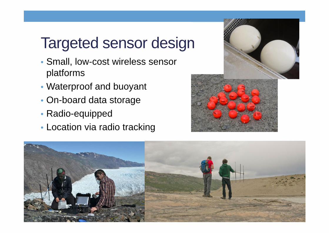
Targeted sensor design• Small, low-cost wireless sensor
platforms• Waterproof and buoyant• On-board data storage• Radio-equipped• Location via radio tracking

Two methods• E-Tracers: along flowpath
• Small, low-cost platforms• Single parameter• Data stored on internal memory• Transmission of location and/or summary data• Potential recovery on emergence from subglacial portal for
data download
• Cryoegg: long term deployments• Larger platform, multiple sensors• Larger transmitter• All data transmitted four times per day• Sensor recovery unlikely

ETracers: Design• 50mm sphere• PIC microchip• Honeywell pressure sensor• Radio frequency chip with helical antenna• Li ½ AA battery (3 month lifetime with 2s chirp, variable)• Adjustable buoyancy epoxy potting compound
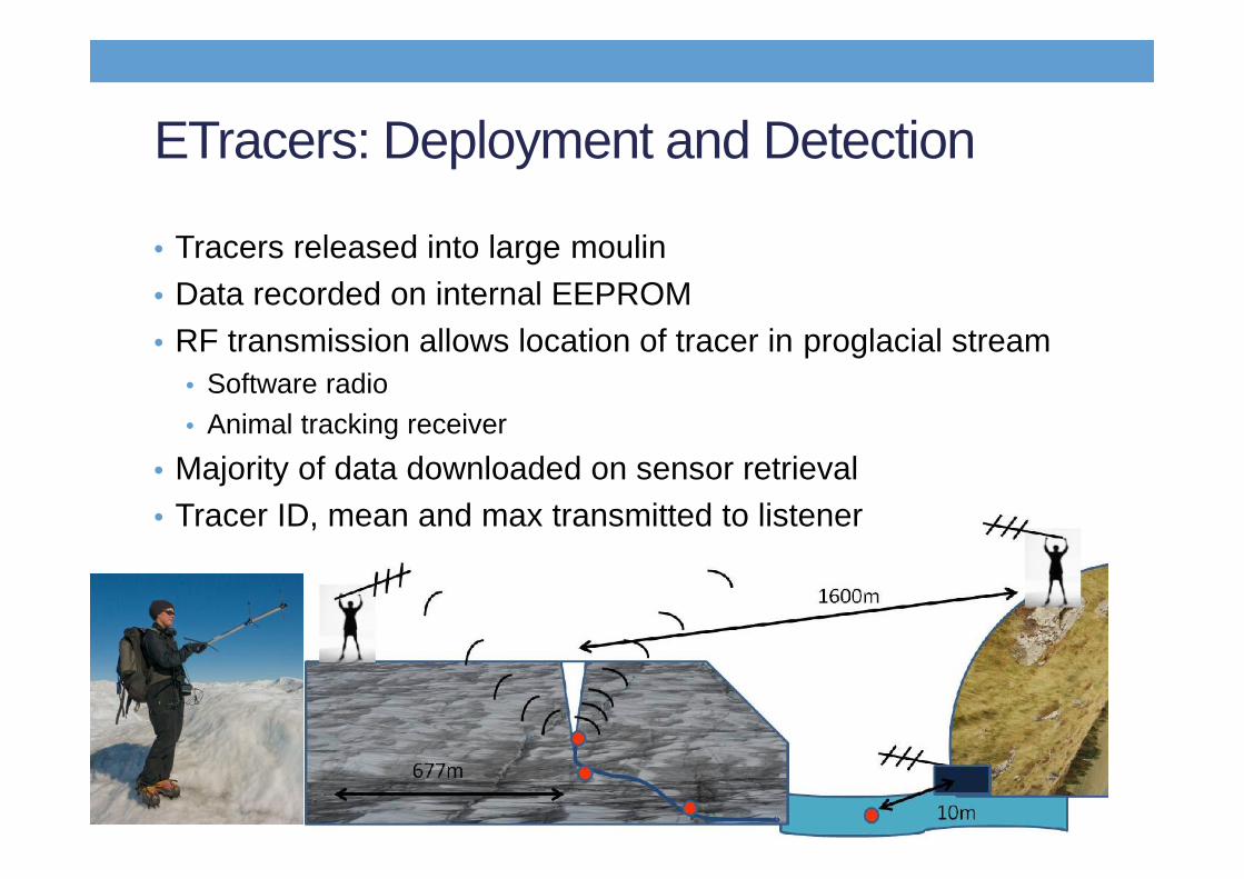
ETracers: Deployment and Detection
• Tracers released into large moulin• Data recorded on internal EEPROM• RF transmission allows location of tracer in proglacial stream
• Software radio• Animal tracking receiver
• Majority of data downloaded on sensor retrieval• Tracer ID, mean and max transmitted to listener
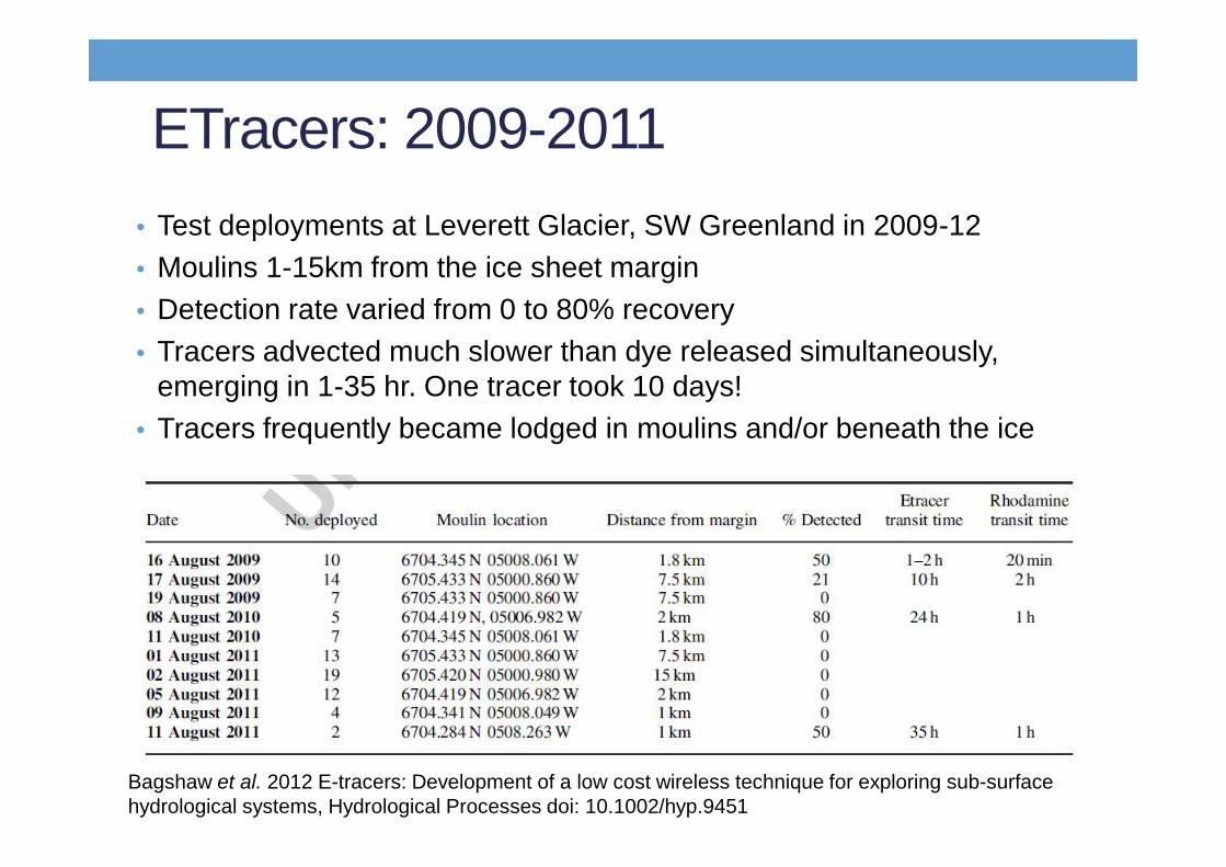
ETracers: 2009-2011• Test deployments at Leverett Glacier, SW Greenland in 2009-12• Moulins 1-15km from the ice sheet margin• Detection rate varied from 0 to 80% recovery• Tracers advected much slower than dye released simultaneously,
emerging in 1-35 hr. One tracer took 10 days!• Tracers frequently became lodged in moulins and/or beneath the ice
Bagshaw et al. 2012 E-tracers: Development of a low cost wireless technique for exploring sub-surfacehydrological systems, Hydrological Processes doi: 10.1002/hyp.9451

ETracers: 2012-2014• Radio chirp used to transmit data to automated listening
station• Data transmitted through 100m ice and 1km (noise-free) air• Tracer ID allows assignment of data to each tracer• One tracer passed through drainage system over 12 days• Water level retrieved from crevasses
Bagshaw et al. 2014 Annals of Glaciology
Cryoegg
Bagshaw et al. 2014 Annals of Glaciology
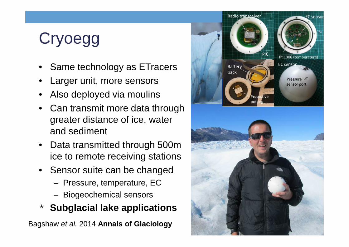
• Same technology as ETracers• Larger unit, more sensors• Also deployed via moulins• Can transmit more data through
greater distance of ice, waterand sediment
• Data transmitted through 500mice to remote receiving stations
• Sensor suite can be changed– Pressure, temperature, EC– Biogeochemical sensors
* Subglacial lake applications
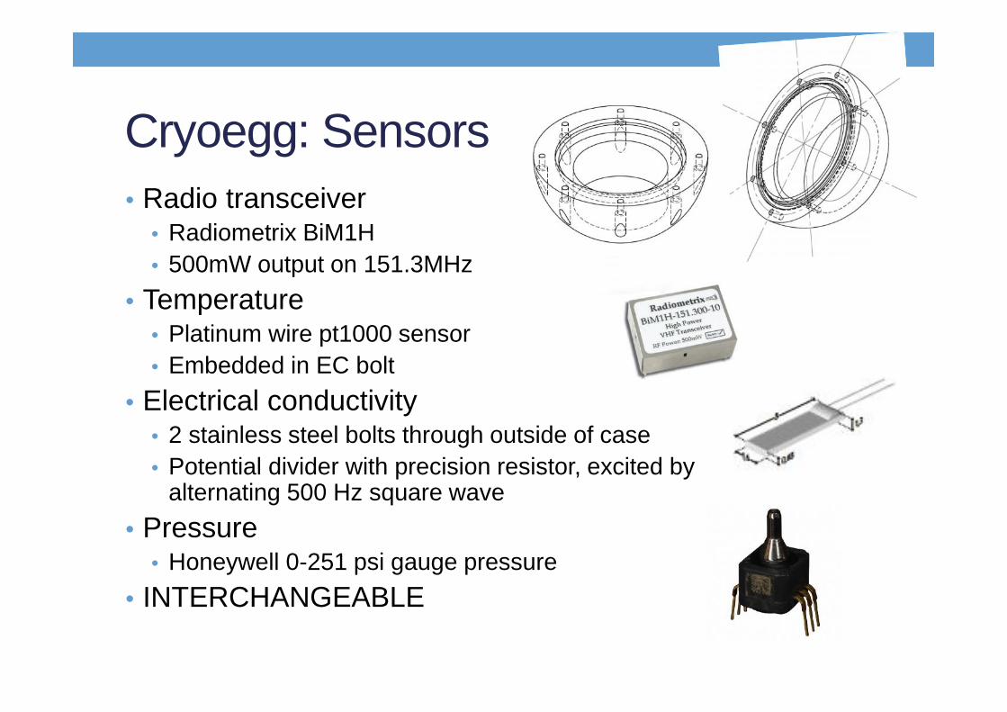
Cryoegg: Sensors• Radio transceiver
• Radiometrix BiM1H• 500mW output on 151.3MHz
• Temperature• Platinum wire pt1000 sensor• Embedded in EC bolt
• Electrical conductivity• 2 stainless steel bolts through outside of case• Potential divider with precision resistor, excited by
alternating 500 Hz square wave• Pressure
• Honeywell 0-251 psi gauge pressure• INTERCHANGEABLE

Cryoegg tests
Bagshaw et al. 2014 Annals of Glaciology
• 30m deep moulin with 5m plunge pool• Clear data reception through 500m ice
• 12m deep lake• Clear reception 12m water 50m air• 24hr data received at set time every day• EC, T and P sensors performed well

Cryosphere summary• Simple, low cost sensors that use off-the-shelf
components• Sensors can transmit data through up to 500m ice and
15m water• Data received through up to 2km air• EC, T and P sensors all operational• Receivers are flexible:
• Portable, handheld set-up• Unattended, automated set-up
• ETracers can travel in constricted meltwater flows

Adaptation to temperate systems• Sensors are powerful method for collecting and
transmitting simple data from water to shore• Could be utilised in UK catchment monitoring applications• NERC Impact Accelerator Project: WISWI
• Capture user requirements• Add new sensors to ETracer• Find user-friendly way of capturing data

Potential applications• ‘Free-ranging egg’ Issues with sensor recovery
• Pipe monitoring Issues with data recovery through pipes
• Inundation monitoring• Water quality indicator monitoring
• Enhance existing monitoring schemes• Enable data collection from ungauged reaches• Provide early warning system for water quality• Show evidence for and efficacy of changes to land management:
Upstream Thinking• Engage water users in data collection and management

Requirements • Low cost• EC, T and P sensors• Maintenance free• User-friendly data reception• User-friendly data management• WISECAM system

ETracer for rivers• Sensor platform currently
undergoing redevelopment• EC and T sensors incorporated
into P platform• Shell and electronics require
redesign prior to massproduction
• Receiver will be redevelopedin summer 2015• Small, pocket-sized platform• Easy to use, just displays
received data from sensors

App for data reporting• Easy method for getting data from
river to database• Eliminates manual data reporting• Incentivises data collection• Allows real-time data viewing• Enables citizen science
• Users can collect data and directlyupload
• Can view all data from local andregional sites
• Engages water users in management
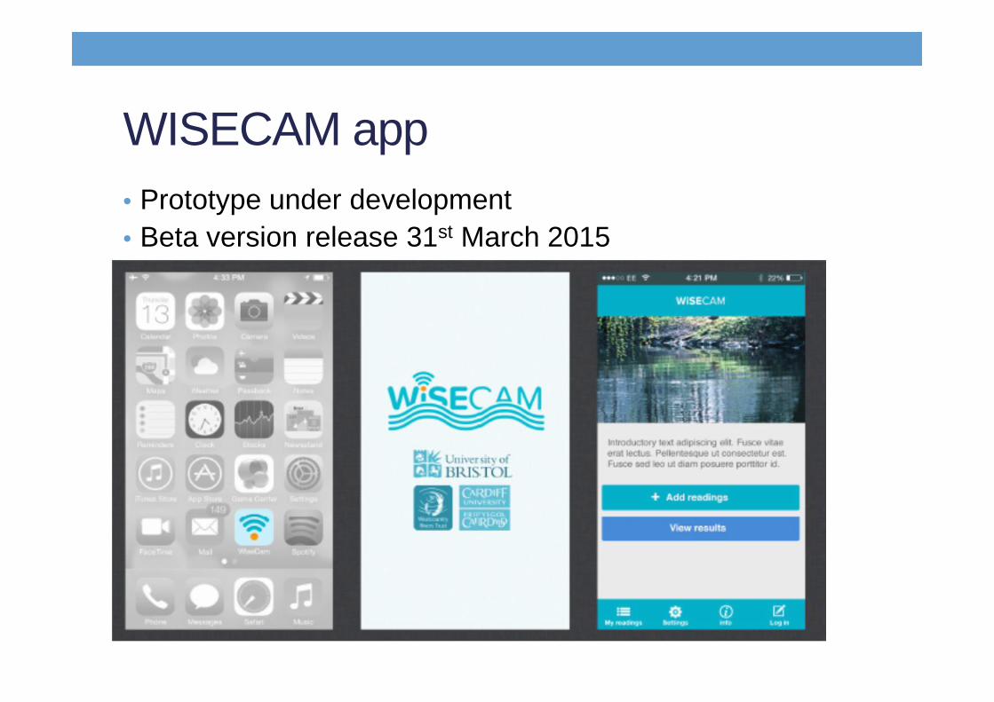
WISECAM app• Prototype under development• Beta version release 31st March 2015
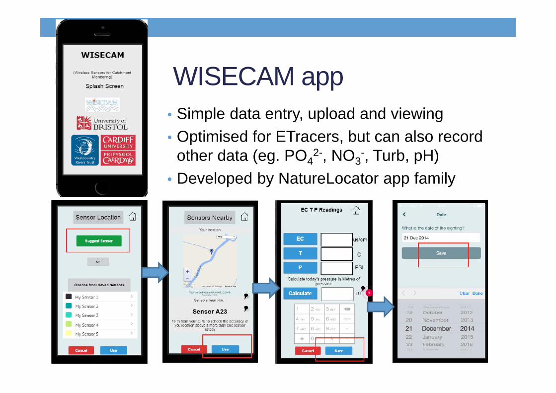
WISECAM app• Simple data entry, upload and viewing• Optimised for ETracers, but can also record
other data (eg. PO42-, NO3
-, Turb, pH)• Developed by NatureLocator app family

WISECAM app and database• Data uploaded to publicly accessible database
• Log-in required, so users traceable• Data can be viewed in app or
online• Graphing available on app• Plans for ‘traffic light’ map for EC, T
and P• All data located and timestamped• App will be free to download• Android only at present, IOS to
follow
TESTERS REQUIRED!

Potential uses• Fixed-point:
• High spatial resolution monitoring• High temporal resolution
monitoring• Simple parameters for
characterisation• Real-time data reporting
• Free-range:• Along flowpath data
• If sensor recovery can be ensured• Data from set depths• Distributed floodplain data:
inundation logging
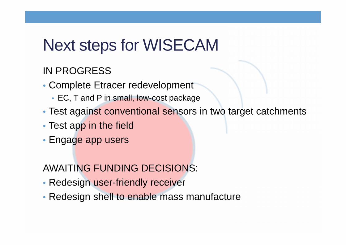
Next steps for WISECAMIN PROGRESS• Complete Etracer redevelopment
• EC, T and P in small, low-cost package
• Test against conventional sensors in two target catchments• Test app in the field• Engage app users
AWAITING FUNDING DECISIONS:• Redesign user-friendly receiver• Redesign shell to enable mass manufacture

• Wireless sensors can be really useful in catchments• Techniques developed in glacial environment can be
applied to temperate catchments• Not a replacement for conventional monitoring, but can
collect data in different places and at different scales• Use simple data to represent complex processes
• Early-warning systems• Easy to use: citizen science• Direct data upload
Wireless sensors have potential to revolutionisemonitoring of freshwater environments
Only if intelligently designed and sensibly deployedNeed to understand both system and sensor for best results
More complex is not always betterEntirely new datasets, potentially largeData management must be considered