framework geologic map and structure sections along the
TRANSCRIPT

By Robert J. McLaughlin, Barry C. Moring, Christopher S. Hitchcock, and Zenon C. Valin
Pamphlet to accompany
Scientific Investigations Map 3395 Version 1.1, September 2018
2018
U.S. Department of the InteriorU.S. Geological Survey
Prepared in Cooperation with Pacific Gas and Electric Company
Framework Geologic Map and Structure Sections along the Bartlett Springs Fault Zone and Adjacent Area from Round Valley to Wilbur Springs, Northern Coast Ranges, California

U.S. Department of the InteriorRYAN K. ZINKE, Secretary
U.S. Geological SurveyJames F. Reilly II, Director
U.S. Geological Survey, Reston, Virginia: 2018 First release: 2018 Revised: September 2018 (ver. 1.1)
For more information on the USGS—the Federal source for science about the Earth, its natural and living resources, natural hazards, and the environment—visit http://www.usgs.gov/ or call 1–888–ASK–USGS (1–888–275–8747).
For an overview of USGS information products, including maps, imagery, and publications, visit http://www.usgs.gov/pubprod/.
Any use of trade, firm, or product names is for descriptive purposes only and does not imply endorsement by the U.S. Government.
Although this information product, for the most part, is in the public domain, it also may contain copyrighted materials as noted in the text. Permission to reproduce copyrighted items must be secured from the copyright owner.
Suggested citation: McLaughlin, R.J., Moring, B.C., Hitchcock, C.S., and Valin, Z.C., 2018, Framework geologic map and structure sections along the Bartlett Springs Fault Zone and adjacent area from Round Valley to Wilbur Springs, northern Coast Ranges, California (ver. 1.1, September 2018): U.S. Geological Survey Scientific Investigations Map 3395, 60 p., https://doi.org/10.3133/sim3395.
ISSN 2329-132X (online)

iii
Contents
Introduction.....................................................................................................................................................1Present and Previous Studies ............................................................................................................1Acknowledgments ................................................................................................................................1
Geologic Setting .............................................................................................................................................2Lithologic and Structural Features of the Metamorphic Basement Terranes .....................................4
Franciscan Complex .............................................................................................................................4Central Belt ...................................................................................................................................4
Pomo Terrane (Upper Cretaceous to Upper Jurassic) .................................................4Marin Headlands-Geysers Terrane (Upper Cretaceous–Upper Jurassic) ...............4Snow Mountain Volcanic Terrane (Lower Cretaceous–Valanginian or younger) ...5
Eastern Belt...................................................................................................................................5Yolla Bolly Terrane (Upper and Lower Cretaceous to Upper Jurassic, Tithonian) ..6Pickett Peak Terrane (Lower Cretaceous, Aptian–Barremian)...................................7Mendocino Pass Terrane (Lower Cretaceous, Valanginian) .......................................7
Coast Range Ophiolite (Upper and Middle Jurassic) .....................................................................8Great Valley Complex ....................................................................................................................................8
Elder Creek Terrane of the Great Valley Complex (Lower Cretaceous and Upper to Middle Jurassic) ...................................................................................................................................8
Structural Relations .......................................................................................................................................8Major Faults ...........................................................................................................................................8
Coast Range Fault ........................................................................................................................8Bartlett Springs Fault Zone ........................................................................................................9
Northern Bartlett Springs Fault Zone ..............................................................................9Displacement on the Northern Bartlett Springs Fault .........................................9Lake Pillsbury Releasing Bend ..............................................................................10Seismicity of the Northern Bartlett Springs Fault Zone ....................................11Fault Creep along the Northern Bartlett Springs Fault ......................................13
Southern Bartlett Springs Fault Zone ............................................................................15Faults of the Middle Mountain and Sanhedrin Mountain Areas ..............................16Faults of the Clear Lake Area ..........................................................................................16Faults Northeast of the Bartlett Springs Fault Zone ...................................................17
Major Folds ..........................................................................................................................................18Wilbur Springs Dextral Hook ...................................................................................................18
Antiforms and Synforms ..................................................................................................19Bartlett Springs Synform ........................................................................................19Wilbur Springs Antiform .........................................................................................20Pacific Ridge Antiform ............................................................................................20Bartlett Mountain Antiform ....................................................................................20Middle Mountain Synform ......................................................................................20
Description of Map Units ...........................................................................................................................20Unconsolidated Deposits ..................................................................................................................20Alluvial Deposits..................................................................................................................................20Terrace Deposits .................................................................................................................................21Fan Deposits ........................................................................................................................................21Glacial Deposits ..................................................................................................................................21Spring Deposits ...................................................................................................................................21Volcanic Rocks ....................................................................................................................................22Fluvial and Lacustrine Fill ..................................................................................................................22

Figures
1. Map showing location of the map area, the Lake Pillsbury study area of Ohlin and others (2010), the Bartlett Springs Fault Zone, and other major faults east of the San Andreas Fault in the Coast Ranges of northern California............................... sheet 1 2. Map showing quadrangles in map area and sources of geologic data....................sheet 2 3. Location of map area in northern California plotted on 30-m hillshade base, showing principal access roads and nearby towns.................................................. sheet 1 4. Generalized geologic map of northern California showing location of map area, the Lake Pillsbury study area of Ohlin and others (2010), the Bartlett Springs Fault Zone, the Maacama Fault Zone, and the distribution of principal belts of the Franciscan Complex..................................................................................................sheet 1 5. Map showing major structural features in map area....................................................sheet 2 6. Geologic maps showing progressive deformation of the northern California margin during transition from subduction to right-lateral strike slip........................sheet 2 7. Schematic reconstruction of Bartlett Springs Synform configuration prior to its dismemberment along the Northern Bartlett Springs Fault Zone.............................sheet 2 8. Map showing Wilbur Springs Dextral Hook in context of regional structure and long-term transpressional deformation along the Northern Bartlett Springs Fault Zone...................................................................................................................................sheet 2 9. View southeast at serpentinite diapir in Bartlett Springs Fault Zone north of Coyote Rocks and Lake Pillsbury..................................................................................................................11 10. Views southeast across Bartlett Springs Fault Zone north of Coyote Rocks, distinguished by serpentinite diapir within stream-cut exposure along Salmon Creek................................. 12 11. Map of double-differenced locations for epicenters of the main shock and aftershocks of the August 10, 2016, M 5.1 earthquake on the Northern Bartlett Springs Fault......................14 12. Seismicity cross sections showing hypocentral depth distribution of earthquakes along sections t1, t2-6, t-3, t-4, and t-5..............................................................................................sheet 2 13. Histogram showing main shock and aftershocks defining the August 10, 2016, earthquake sequence on the Northern Bartlett Springs Fault Zone...............................................................15 14. Map showing locations and locality numbers of fossils listed in table 1 (https://doi.org/10.3133/sim3395) and plotted on the geologic map (sheet 1)................... 33
Marine Overlap Deposits ...................................................................................................................22Great Valley Complex ........................................................................................................................22
Elder Creek Terrane ...................................................................................................................22Coast Range Ophiolite ........................................................................................................................24Franciscan Complex ...........................................................................................................................25
Central Belt .................................................................................................................................25Central Belt Mélange terrane .........................................................................................25
Eastern Belt.................................................................................................................................26Yolla Bolly terrane .............................................................................................................26Pickett Peak .......................................................................................................................27Medicine Pass ...................................................................................................................27
References Cited..........................................................................................................................................27
Table 1. Paleontological data from Tertiary and Mesozoic rocks of the map area from
Round Valley to Wilbur Springs, northern Coast Ranges, California .................................34
iv

1
IntroductionThis geologic mapping investigation was undertaken by the
U.S. Geological Survey (USGS) in cooperation with Pacific Gas and Electric Company (PG&E) under a joint USGS-PG&E CRADA agreement to determine the extent, complexity, architecture, and evolution of the Bartlett Springs Fault Zone between Clear Lake and Round Valley, California. The Bartlett Springs Fault Zone is the eastern-most known active member of the San Andreas transform margin in northern California (fig. 1, sheet 1) and is of particular interest for its apparent long-lived history as a Miocene and older subduction-margin fault that, more recently, was reactivated as an active, creeping member of the San Andreas Fault system. The northern part of the Bartlett Springs Fault Zone is apparently still influenced by subduction of the Gorda Plate beneath North America, but it is also accommodating strike-slip displacement associated with Pacific Plate interaction with North America (fig. 1, sheet 1). South of the map area, the Bartlett Springs Fault Zone has been shown to step into and merge with active faults of the eastern San Francisco Bay region; to the north of the map area and Round Valley, the fault zone steps into several other fault zones, such as the Lake Mountain Fault (Herd, 1978), that connect with offshore thrust faults of the Cascadia subduction margin (Carver, 1987; Clarke, 1990; Clarke and Carver, 1992; Lienkaemper, 2010; McLaughlin and others, 2000). PG&E owns or operates hydro-electric facilities and infrastructure in northern California that are directly or indirectly impacted by the Bartlett Springs Fault Zone, so the geologic framework of the region along and adjacent to the fault zone as depicted in this study are of interest to PG&E for planning and upgrading purposes.
Present and Previous Studies
Previous geologic mapping in the area of this investigation has occurred sporadically for more than six decades, with focus on different aspects of the framework geology at different times, and most of the mapping has not been formally published (see fig. 2, sheet 2). These studies include investigations in the 1960s to 1970s, mostly at 1:62,500 scale, by the California Department of Water Resources (CDWR) for construction of tunnels to divert and transport water from the Eel River drainage system; quadrangle mapping in the 1950s and 1970s by Ph.D. students at the University of Texas, Austin, and Stanford University; mapping by John Suppe and students at Princeton University in the 1960s to 1980s; and some M.S. thesis mapping of a few small areas in the 1970s and 1980s by students at California State University, Hayward, and at San Jose State University.
A large part of this geologic mapping investigation has involved the compilation of previously unpublished mapping and its merging with published mapping by the USGS in the Covelo 30ʹ × 60ʹ quadrangle to the north (Jayko and others, 1989), with 1:30,000-scale (Ohlin and others, 2010) and 1:62,500-scale (Etter, 1979) mapping in the Lake Pillsbury region, and with 1:24,000-scale mapping in the Clear Lake region to the south (for example, Hearn and others, 1995; McLaughlin and others, 1990; McLaughlin, 1978).
In 2012–14, new geologic reconnaissance mapping was conducted across the Bartlett Springs Fault Zone corridor in Mendocino National Forest and adjacent areas north of Clear Lake. For this new field work, we traversed the region on Forest Service and county roads (fig. 3, sheet 1), collecting structural,
stratigraphic, and lithologic data and sampling for petrographic work. We used Google Earth and high-altitude air-photo imagery to delineate approximate boundaries, distribution, and continuity of mélange terrains, intact rock units, and ultramafic rocks composing the Mesozoic and Tertiary basement of the map area. We also delineated major landslides and linear features associated with faulting (fig. 4, sheet 1; sheets 1, 2). For some traverses, a computer operated from our field vehicle enabled us to enter field data into a digital database in the field. For other traverses, field data was not entered until return to the office.
Christopher Hitchcock conducted mapping of the Quaternary geology in northern Clear Lake basin, Potter Valley, and associated subsidiary basins and drainages in 2012–14. This mapping, delineating the stratigraphy of Quaternary fluvial, stream, and terrace deposits, was integrated with the mapping of McLaughlin and Moring during the compilation process. Major landslide deposits mapped by McLaughlin and Moring and separately by Hitchcock were combined in the map database. Only large, major landslide deposits are shown on this geologic map. The reader is herein referred to detailed landslide and slope stability maps by the California Geological Survey (http://www.conservation.ca.gov/cgs/geologic_hazards/landslides) and the USGS (https://www2.usgs.gov/natural_hazards/) to determine more accurately the hazard posed by landsliding in this region. Faults interpreted as geomorphically youthful, active parts of the Bartlett Springs Fault Zone, shown by red fault lines on the geologic map, are incorporated from Lienkaemper (2010).
In this report, geologic ages and designations of Mesozoic periods and epochs are taken from the Geologic Time Scale of the Geological Society of America (Walker and others, 2012; Geologic Time Scale, v. 4.0, Geological Society of America, https://doi.org/10.1130/2012.CTS004R3C). Cenozoic and Quaternary epochs are based on their assignments by the U.S. Geological Survey Geologic Names Committee, 2010.
Acknowledgments
The mapping investigation was funded from a Cooperative Research and Development Agreement (CRADA) between the Earthquake Hazards Program of the U.S. Geological Survey (USGS) and Pacific Gas and Electric Company (PG&E) as a follow-up to an earlier USGS-PG&E CRADA-funded geologic mapping investigation of the Bartlett Springs Fault Zone in the Lake Pillsbury area (Ohlin and others, 2010). The authors have appreciated the continued interest and encouragement from Scott Steinberg (PG&E Geosciences Department) in this investigation. Steinberg also provided access to several unpublished reports prepared by PG&E geotechnical consultants, as well as photographs taken from a helicopter reconnaissance of the region by Steinberg and Hitchcock in 2012 that were helpful in our map compilation.
Diane Moore (USGS Earthquake Science Center) provided the senior author with expert consultation and corroboration on mineralogy and petrography of serpentinitic fault rocks along the Bartlett Springs Fault Zone at several localities in the map area, as well as help with numerous petrographic issues with the Franciscan Complex.
Large wildfires that prompted extended road closures in Mendocino National Forest during the course of our mapping

2
study made it critical to establish good communications with the U.S. Forest Service. We are grateful to them for their cooperation, particularly personnel in the Upper Lake (A. Downhour and D. Mackintosh), Willows (R.P. Mikulovsky), and Red Bluff (D.R. Elder and J.A. Delafuente) offices, for providing us with updated Forest Service road maps, road conditions, gate access, and contact information for private landowners within Mendocino National Forest. We thank several landowners in the map area for providing access to their land in the course of mapping, as well as information on the drivability of access roads. Northeast of Willits, we thank the Adams family, owners of Emandel Resort for access to their land and for providing information on access along other parts of the Eel River. In Rice Valley and the McCloud Creek area, the Kompf family and Dave Rinker were helpful in allowing access to their land in Rice Valley and sharing a long-term knowledge of this area.
This mapping investigation has cooperated with the Geology, Minerals, Energy, and Geophysics Science Center (GMEG) Delta project (R. Graymer, USGS project lead), a 3–D framework geologic mapping investigation that includes the area between Wilbur Springs to the north and Lake Berryessa to the south, as well as the subsurface of southwestern Sacramento Valley and the San Francisco Bay part of the Sacramento-San Joaquin Delta.
The report was peer reviewed for scientific content by P.A. Stone and B. Melosh (both at GMEG Science Center, USGS).
Geologic SettingThe area of this geologic mapping investigation is in
the northern coast ranges of California. Complexly deformed Mesozoic and lower Cenozoic rocks of the Franciscan Complex, an accumulation of sedimentary, metamorphic, and igneous rocks that were assembled in a subduction zone and accreted to the western continental margin between the Late Jurassic and Miocene, underlie the region. Oceanic rocks of the Coast Range ophiolite that form the basement of coeval fore-arc strata of the Great Valley complex structurally overlie the Franciscan Complex. Subduction continues at present in the modern Cascadia subduction margin northwest of the map area but has been largely replaced by dextral strike-slip faulting associated with northward propagation of the San Andreas transform system in the map area.
A consequence of the very long history of deposition of strata in the Franciscan Complex is that these rocks were intensely deformed during several episodes of subduction-accretion that formed three broad, westward-younging structural belts. These belts, the Eastern, Central, and Coastal Belts, are younger, but overlap in age westward, and pressure/temperature (P/T) conditions from metamorphic mineral assemblages in the rocks in each belt imply that the depth to which the rocks were subducted increases eastward. Due in part to oblique subduction-accretion, some of the Franciscan rocks, particularly oceanic basaltic rocks and their overlying pelagic sedimentary covers in the Central Belt, have undergone relatively large northward translation along the eastern Pacific Ocean margin since the Jurassic. This complex structural framework was followed in the Early to middle Cretaceous (Hauterivian–Albian), and even later in the Late Cretaceous (Maastrichtian) to early Tertiary (early Eocene), by uplift of the subduction complex, extensive detachment faulting in the overlying ophiolitic and lower sedimentary section of the fore arc, and unroofing of the deeply subducted Eastern and Central Belts of
the Franciscan Complex. This unroofing of the Coast Ranges and exposure of deeply subducted Franciscan rocks to erosion has been linked to shallowing of Farallon Plate subduction during the Laramide orogeny (Saleeby, 2003; Dickinson and others 1979). In northern and central California, this was accompanied at depth by east-directed emplacement of Franciscan rocks as tectonic wedges into the western Great Valley fore arc and the mafic igneous and metamorphic rocks of the Sierra Nevada batholith (Ernst and McLaughlin, 2012; Wentworth and others, 1984; Wentworth and Zoback, 1990).
The Franciscan Complex is structurally overlain in the map area by the Jurassic Coast Range ophiolite, which is highly disrupted as the result of (1) extensional shearing and serpentinization of the structurally low ultramafic section of the ophiolite during its upward migration from mantle to midcrustal levels in the Jurassic and (2) later contraction and extension that corresponded with unroofing of the Franciscan Complex in the Late Cretaceous and Tertiary. Although still debated, the ophiolitic rocks are widely considered to have formed in a fore-arc, supra-subduction setting east of the paleotrench in which the Franciscan Complex was assembled (Shervais and others, 2005a, b; Ernst and McLaughlin, 2012). Serpentinite matrix mélange that forms a large part of the ultramafic section of the Coast Range ophiolite and is attributed to low-angle extension (Jayko and others, 1987) may result both from the Jurassic and the Late Cretaceous–early Tertiary deformation.
Unmetamorphosed sedimentary rocks of the Upper Jurassic Great Valley fore arc were initially deposited unconformably on extrusive and high-level intrusive rocks of the ophiolitic basement of the map area. The Upper Jurassic to Lower Cretaceous (Hauterivian and younger) part of this sedimentary section, however, was subsequently deformed by folding and attenuated with the underlying ophiolite.
This deformation resulted in incorporation of the lower Great Valley sedimentary section into a regionally extensive thick zone of mélange (here mapped as ophiolitic mélange; earlier mapped as Grizzly Creek mélange terrane near Wilbur Springs by McLaughlin and Ohlin, 1984) consisting of rocks of the Coast Range ophiolite tectonically mixed with Upper Jurassic and Lower Cretaceous strata of the Great Valley sedimentary section (McLaughlin and others, 1990; also see photos of “Grizzly Creek mélange terrane” in McLaughlin and Ohlin, 1984). Significant penetrative shearing in the serpentinized ultramafic rocks of the map area may reflect upward migration of these rocks to the ocean floor from mantle depths in the Jurassic. Continued unroofing of ophiolitic basement is reflected in the Late Jurassic (Oxfordian–early Tithonian) deposition of coarse megabreccia derived from the Coast Range ophiolite at the base of the Great Valley complex sedimentary section. Exposure of serpentinite on the seafloor during early Great Valley complex evolution further led to deposition of sedimentary serpentinite (unit Kssp) in Valanginian–Hauterivian time.
Detachment faulting rooted along the serpentinized base of the Coast Range ophiolite (Jayko and others, 1987), which involved both the ophiolite and the lower Great Valley complex (McLaughlin and others, 1990), produced ophiolitic mélange (unit KJom). The timing of extension associated with formation of the ophiolitic mélange was Early Cretaceous (Valanginian) or younger, based on the youngest fossils present in sedimentary slabs and blocks in the mélange (McLaughlin and others, 1990). The somewhat younger (Valanginian–Hauterivian) sedimentary serpentinites and associated complex folding in the overlying
3
lower Great Valley section could reflect extensional deformation in the stratigraphically lower part of the section. Erosion of the unroofed Coast Range ophiolite apparently resulted in deposition of ophiolite-derived sediment in the fore-arc basin as olistostromal deposits of serpentinitic breccias and sandstones (”sedimentary serpentinites” of this report). Early Cretaceous (Hauterivian) cold-seep-related fossil faunas are associated with some of the sedimentary serpentinites, but fossils this young are not known as part of the ophiolitic mélange (McLaughlin and others, 1990; Campbell and others, 1993; Campbell and others, 2002, 2008; Kiel and others, 2008).
Others (for example, Macpherson and Phipps, 1988) have interpreted both the serpentinized ultramafic rocks and ophiolitic mélange units of this report to be olistostromal and explain their penetrative fabrics as formed by large-scale gravitational collapse. This implies that penetrative deformation of the serpentinized ultramafic rocks (unit Josp) and ophiolitic mélange (unit KJom) was a process that occurred in the shallow lithosphere. Although near-surface sedimentary processes are clearly associated with deposition of Lower Cretaceous (Hauterivian) sedimentary serpentinites (unit Kssp) in the lower Great Valley complex, tectonic shearing and boudinage in the serpentinized ultramafic rocks (unit Josp) and ophiolitic mélange (unit KJom) lack clear evidence of a sedimentary origin and, as pointed out, some of the penetrative deformation in the serpentinized ultramafic rocks was likely imposed during upward migration of the serpentinite from the mantle to the ocean floor in the Jurassic and later. Detachment and attenuation faulting in the serpentinized ultramafic rocks and ophiolitic mélange units is here viewed as too deep-seated to be easily relatable to near-surface processes. The mélange process may be linked to progressive shallowing of subduction and unroofing of the Coast Ranges that continued into the Late Cretaceous and early Tertiary during the Laramide orogeny.
Both the ophiolitic mélange and the sedimentary serpentinite in the Lower Cretaceous section of the Great Valley complex resulted from deep unroofing of the Coast Range ophiolite and (or) buried mafic basement beneath the northern Sacramento Valley (Jayko and others, 1987; Wentworth and others, 1984; Macpherson and Phipps, 1988). In contrast to sedimentary processes involved with deposition of the sedimentary serpentinite, the ophiolitic mélange, instead, may have formed as a series of low-angle detachments associated with extension at depth. Extension that triggered unroofing of ophiolitic basement must have followed Valanginian basinal deposition of Great Valley strata incorporated into the ophiolitic mélange. In the Hauterivian, deposition of unroofed and recycled ophiolitic debris occurred in the fore arc, including olistostromal deposits and sedimentary serpentinite. Fluids associated with cold-seep-related fossil faunas in the sedimentary serpentinites may well have been channeled along detachment structures.
Another major pulse of uplift and unroofing of Franciscan Complex basement in the region occurred between the latest Cretaceous (Maastrichtian) and late Paleocene, as indicated by local remnants of Paleocene to Eocene fore-arc-basin strata preserved near Covelo and Rice Valley and in the Lower Lake area that are unconformable on underlying Great Valley strata. In Rice Valley, a local conglomerate unit at the base of upper Paleocene strata that is unconformable on the Upper Cretaceous
section contains clasts of lawsonitic metagraywacke derived from the Franciscan Complex. This relation suggests (for example, Berkland, 1973) that the Franciscan source of the lawsonitic metasandstone was exhumed from subducted depths greater than 25 km between the latest Cretaceous (~66 Ma) and late Paleocene (~56 Ma).
In the late Miocene (~8–5 Ma), following this major tectonism over the subduction margin, faulting in the northern Coast Ranges between Covelo and Clear Lake began to link southward to the northwardly propagating transform system. Faults of the transform system to the south extended into the accretionary margin inboard of the present San Andreas Fault and Mendocino Triple Junction. The Bartlett Springs Fault Zone appears to be a fault zone present in the Miocene and older subduction margin that provided a pre-existing zone of crustal weakness that accommodated the transition from dominant subduction convergence to dominant strike slip, with northward propagation of the main San Andreas transform and its more inboard segments (the Hayward-Calaveras-Rodgers Creek-West Napa-Maacama and the Concord-Green Valley-Bartlett Springs Fault Zones).
Starting about 4 Ma, a 70-km-wide band of the northern California margin began its northwest-directed transition from a margin dominated by head-on to oblique subduction-driven convergence to one dominated by transpression and transtension associated with steep faults of the northwardly propagating San Andreas Fault system. The modern Bartlett Springs Fault Zone appears to have developed largely during this period of transition from subduction to strike-slip tectonics. Favorably oriented faults of the Bartlett Springs Fault Zone that initially were active as part of the subduction margin in the Miocene were re-occupied by steeper dipping, discontinuous, stepping strike-slip faults of the transform margin.
The geologic map and accompanying structure sections delineate the course of the active Bartlett Springs Fault Zone over a distance of ~110 km, from the vicinity of Clear Lake northwestward to Covelo. The fault zone is divided into northern and southern segments, separated by a prominent right step, across which the two fault zone segments overlap. The northern Bartlett Springs Fault Zone appears to follow a complex northwest-oriented path of crustal weaknesses that were established in the subduction margin realm, prior to initiation of strike-slip faulting. The southern Bartlett Springs Fault Zone (fig. 5, sheet 2), which includes the southwest side of a 2.5-km-wide right step southeast of State Highway 20 near Grizzly Spring, departs from the prominent zone of pre-transform deformation and follows a less maturely developed path that cuts across the structural grain of the older pre-transform margin. The southeasternmost mapped extent of the northern Bartlett Springs Fault Zone segment east of the right step, separating it from the southern segment, overlaps the southern segment for ~5 km. The overlapping part of the northern segment, however, does not exhibit geomorphically youthful fault features (see later description of northern and southern Bartlett Springs Fault Zone). Farther southeastward, this overlapping segment of the northern Bartlett Spring Fault Zone may die out as a bedding plane-parallel fault within strata of the Mesozoic Great Valley complex, though its full extent is unknown and the focus of more detailed ongoing investigations by the USGS.

4
Lithologic and Structural Features of the Metamorphic Basement Terranes
Franciscan Complex
The Franciscan Complex is considered to represent the “type” subduction-zone rock assemblage of the eastern Pacific basin rim (for example, Ernst and McLaughlin, 2012). Subdivisions of the Franciscan Complex are based on their field and aerial map expression, integration of numerous informal local unit names applied to various parts of the Franciscan at different times, and regional geologic mapping and geophysical investigations (Jayko and others, 1989; McLaughlin and others, 2000; Blake and others, 1992, 2000; Lanphere and others, 2007, 2011). The Correlation of Map Units (sheet 2) summarizes the tectonostratigraphic framework of these rocks as used in this report. Regionally, the Franciscan Complex is divided into three thick, eastwardly inclined and folded, sheet-like belts, containing rocks that generally become younger but overlap in age westward. These belts, referred to from northeast to southwest as the Eastern, Central, and Coastal Belts (Irwin, I960; Bailey and others, 1964), include rocks that were metamorphosed at high P/T conditions (for example, blueschist facies, deeply subducted to tens of kilometers) in the Eastern Belt, at intermediate P/T conditions (for example, low greenschist facies burial conditions) in the Central Belt, and at much lower P/T conditions in the Coastal Belt (for example, zeolite to prehnite-pumpellyite facies), where maximum structural burial was only to a few kilometers (Ernst and McLaughlin, 2012). Rocks assigned to the Eastern and Central Belts of the Franciscan Complex are present in the map area, but the Coastal Belt is at the surface only to the west of the map. If conceptual views of crustal structure are valid, however, it may underlie rocks of the Central Belt at some depth in the western part of the map area.
Several subsidiary map units are recognized in the Eastern and Central Belts, which we consider to be fault-bounded and which we refer to as tectonostratigraphic terranes of the Eastern or Central Belts. We also recognize subunits of mélange in both the Eastern and Central Belts that may be of different age and which are mapped as different units. Mélanges in both belts, however, contain similar high-grade blueschist blocks (for example, glaucophane schist, eclogite, and amphibolite) that may be derived from the same or similar protoliths. The matrix material of these mélange terranes in the Eastern and Central Belts differ in metamorphic grade, consistent with metamorphism of the belts in which they occur.
Central BeltThe Central Belt is the westernmost belt of the Franciscan
Complex exposed in the map area. West of Ukiah valley and U.S. Highway 101, it is underlain structurally by the Coastal Belt beneath a regionally warped low-angle fault referred to as the Coastal Belt Thrust. In the map area, the Central Belt comprises at least 30 to 40 percent of the surface exposures of Franciscan Complex rocks, but it is inferred to structurally underlie the entire area west of Sacramento Valley. The Central Belt is predominantly a large-scale mélange that, along with
meter- to tens-of-meter-scale sheared blocks of blueschist, eclogite, amphibolite, metasandstone, metachert, metaigneous, and ultramafic rocks, also encloses numerous kilometer- to tens-of-kilometers-scale slabs of broken metasandstone and argillite ± pelagic chert or limestone ± basaltic volcanic rocks ± other mafic to ultramafic parts of the Mesozoic ocean floor. Many slabs enclosed by mélange are composed solely of metasandstone and argillite. These various metasedimentary slabs have metamorphic signatures that vary from strongly to moderately foliated blueschist grade to unfoliated low- to medium-greenschist grade (for example, pumpellyite and prehnite-pumpellyite-bearing) and minor zeolite-grade (laumontite-bearing) rocks. The surrounding mélange matrix is no higher than low-greenschist grade (pumpellyite-bearing) to perhaps incipient blueschist grade (traces of lawsonite) locally.
In the map area, we divide the Central Belt into (1) an undivided mélange matrix unit (Central Belt Mélange terrane) and (2) numerous large slab-like bodies of rock enclosed by the undivided mélange matrix. These slabs are mapped either as generic lithotectonic terrane units or, locally, as named terranes (Pomo terrane, Marin Headlands-Geysers terrane, and Snow Mountain volcanic terrane), where a distinctive tectonostratigraphy is evident.
Pomo Terrane (Upper Cretaceous to Upper Jurassic)This unit is recognized only east of Potter Valley, in
the eastern part of the Central Belt, along the contact with serpentinite and structurally overlying Cretaceous strata of the Great Valley complex of Middle Mountain. The rocks of the Pomo terrane appear to represent slabs of a dismembered seamount (Berkland, 1972, 1978). The lower part of this section consists of alkalic basaltic pillow flows, flow breccias, and intrusive diabase, overlain locally by, or intercalated locally with, radiolarian chert. Radiolarians in the chert are Jurassic, equivalent in age to a part of the nearby Geysers chert section. However, the basaltic rocks are overlain unconformably by a thin carbonate-cemented bioclastic basalt-clast breccia, sandstone, and shale containing a latest Cretaceous (Maastrichtian) mollusk fauna that, in turn, is faulted against serpentinite and overlying Upper Cretaceous Great Valley complex strata of the Middle Mountain block or enclosed by undivided mélange of the Central Belt.
Marin Headlands-Geysers Terrane (Upper Cretaceous–Upper Jurassic)
The Marin Headlands-Geysers terrane is named for the two areas south of the area of this map where these rocks have been studied in great detail (McLaughlin and Pessagno, 1978; Pessagno, 1977; Murchey, 1984; Murchey and Jones, 1984; Hagstrum and Murchey, 1993). In the Marin Headlands area and at The Geysers, east of Healdsburg, the terrane consists of a sequence of oceanic basaltic flows and breccia overlain by a section ~67 m (The Geysers) to 80 m (Marin Headlands) thick of pelagic radiolarian chert that, in turn, is depositionally overlain by metasandstone turbidites derived from the Cretaceous continental margin. The radiolaria in the chert sections of the Marin Headlands-Geysers terrane have been studied in great detail and shown to represent a condensed pelagic section deposited on basaltic ocean floor at equatorial latitudes, far

5
from the continental margin, between the Middle Jurassic (Pliensbachian, ~190 Ma) and the early Late Cretaceous (early Cenomanian or late Albian, ~100 Ma). The terrane is widely considered to represent the remnants of an extensive large oceanic igneous province such as an oceanic plateau, similar to the large plateaus preserved on the west side of the Pacific Ocean basin. The overlying metasandstone, of low-greenschist (pumpellyite) grade in these areas, preserves the initial encounter of the oceanic rocks with the North American Plate subduction margin. The metasandstone turbidites were deposited on the oceanic basalt and chert no earlier than Cenomanian time in the Marin Headlands, based on an ammonite (Murchey and Jones, 1984) and recent dating of detrital zircons in the metasandstone (maximum depositional age of ~100 Ma; McPeak and others, 2015). At The Geysers, the chert section is virtually identical in age to the Marin Headlands based on the radiolarian zonation (Murchey and Jones, 1984; Hagstrum and Murchey, 1993). The overlying metasandstone at The Geysers is petrographically similar to the Marin Headlands based on point-count data (McLaughlin and Ohlin, 1984), but an analysis of detrital zircons in the metasandstone showed that the youngest zircon population is 114 Ma (data of G. Gehrels, cited in Dumitru and others, 2015), considerably older than the youngest radiolaria in the underlying Geysers area chert section. This is explained by recognizing that the detrital zircon data from The Geysers provides only a maximum depositional age for the metasandstone overlying the chert and only coincidentally will date actual deposition of sediment transport systems. However, the similarity of framework grain compositions in metasandstones from the Marin Headlands and The Geysers (McLaughlin and Ohlin, 1984) is taken to indicate that the clastic rocks in both areas were derived from a similar set of source regions but may have interacted at somewhat different times with the oceanic rocks due to the large original aerial extent of the chert-basalt terrane (suggested by distribution of similar rocks from Baja California to southern Oregon) or possibly the oceanic rocks had an orientation that was oblique to the margin during accretion.
We have identified several semi-intact, large slabs of broken, complexly intercalated basalt, radiolarian chert, and metasandstone that extend into the map area from The Geysers region to the south and are surrounded by other rocks of the Central Belt. We have assigned these rocks to the Marin Headlands-Geysers terrane, where we have radiolarian ages (table 1; sheet 1) from the cherts, and the basalt-chert-metasandstone relations seem consistent with their correlation to the Marin Headlands-Geysers terrane. Many other large to small blocks of basalt, undated chert, and metasandstone that are enclosed by mélange and adjacent to or near the rocks we assign to the Marin Headlands-Geysers terrane may also be pieces of this terrane. However, they are instead designated only as blocks of chert, basalt, or metasandstone where there is no data to confidently correlate the rocks with the Marin Headlands-Geysers terrane.
Snow Mountain Volcanic Terrane (Lower Cretaceous–Valanginian or younger)
The Snow Mountain volcanic terrane is an unusual sequence of metamorphosed rhyolitic to basaltic volcanic and volcaniclastic rocks interpreted to have formed in a seamount setting (Macpherson, 1983). These rocks were earlier mapped
and assumed to be a structural outlier of a part the Stonyford section of the Coast Range ophiolite (Brown, 1964). Subsequent mapping and petrologic and geochemical study of these rocks by Macpherson (1983), however, showed that the Snow Mountain rocks have undergone low-blueschist-grade metamorphism and thus were subducted with rocks of the Franciscan Complex. Map relations and modeling of the geometry of a thin sheet of ultramafic rocks beneath the Snow Mountain rocks (Griscom, in Brown and others, 1981), suggest that they structurally overlie or are enclosed by mélange of the Central Belt that bounds these rocks to the north, west, and south. Rocks of the Yolla Bolly and Pickett Peak terranes of the Eastern Belt also structurally overlie the Central Belt regionally. However, metavolcanic rocks like those described from the Snow Mountain volcanic terrane have not been recognized in the Yolla Bolly terrane, and metavolcanic rocks of the Pickett Peak terrane are of higher blueschist grade than the Snow Mountain volcanic terrane. We therefore assign the Snow Mountain volcanic terrane to the Central Belt, although we acknowledge that the Snow Mountain rocks could actually represent a seamount accreted with the Yolla Bolly terrane rather than part of the Central Belt. Early work (for example, Brown, 1964) also assumed a Jurassic age for the Snow Mountain volcanic terrane based on an erroneous correlation of metacherts associated with the Snow Mountain volcanic terrane with the radiolarian fauna of cherts in the Coast Range ophiolite at Stonyford. Efforts to separate radiolarians from metachert in the Snow Mountain volcanic section have been unsuccessful (B. Murchey, oral commun., 2015). Consequently, at the time of this writing, reliable age data for the Snow Mountain volcanic terrane do not exist.
Eastern BeltThe Eastern Belt represents the structurally highest belt of
the Franciscan Complex and was the earliest assembled of the three belts. It apparently was subducted to deeper levels, with accompanying higher blueschist-grade metamorphism than in the Central and Coastal Belts (Ernst and McLaughlin, 2012; Dumitru and others, 2010, 2015; Blake and others, 1988). In northern California, development of the higher blueschist-grade metamorphic mineral assemblages was commonly accompanied by textural reconstitution of the metasedimentary rocks to textural zones 2–3 (Blake and others, 1967) and conversion of the metasedimentary rocks to slate, phyllite, and schist, with increasing textural grade. In general, the increase in textural reconstitution and in P/T relations based on metamorphic mineral assemblages has been shown to increase structurally upward in parts of the Eastern Belt that are thrust beneath the Klamath Mountains (Blake and others, 1967). This structurally upward increase in metamorphic grade (“inverted-metamorphic zonation”) is interrupted in places by low-angle faults that may repeat or truncate the gradual upward progression from low- to high-metamorphic mineral assemblage and textural grade (Blake and others, 1967; Worrall, 1981). In parts of the Diablo Range south of San Francisco Bay, this relation is not so clear; here, high P/T neoblastic blueschist minerals, including jadeitic pyroxene, are present in metasandstones that are not highly reconstituted (Raymond, 2014; Ernst, 1971; Wentworth and others, 1999). This suggests that kinematic relations between

6
metamorphic mineral facies and development of metamorphic fabric do not correspond everywhere to equivalent burial depths.
In the map area, we divide the Eastern Belt into the three tectonostratigraphic terranes described below.
Yolla Bolly Terrane (Upper and Lower Cretaceous to Upper Jurassic, Tithonian)
The Yolla Bolly terrane is named for rocks north of the map area in the Yolla Bolly Mountains Wilderness area of the northern Coast Ranges (Blake and Jayko, 1983; Jayko, 1984; Blake and others, 1985; Worrall, 1981). These rocks represent the structurally lower part of the Eastern Belt. Previous workers have used various local names (such as the Taliaferro Complex of Suppe, 1973; the Pacific Ridge Complex of Suppe and Foland, 1978; and the East Clear Lake and Little Indian Valley terranes of McLaughlin and Ohlin, 1984) to describe the character of these rocks in different areas. We include all of these locally named rock units in the Yolla Bolly terrane of this report. Inclusion of rocks in the Little Indian Valley terrane (McLaughlin and Ohlin, 1984) in the Yolla Bolly terrane, however, raises some unresolved issues with the depositional age assignment of the Yolla Bolly terrane.
The Yolla Bolly terrane is divided into two major units in the map area: a structurally low mélange (unit f ym) and a higher unit (unit f ys) of more or less coherent rocks (broken formation). The mélange unit comprises slaty, sheared, and foliated metasandstone and argillite containing blocks and slabs of metagreenstone, metachert, and metaconglomerate, rare blocks of high-grade blueschist and amphibolite locally containing garnet, and rare lenses of metaserpentinite found along shear planes associated with the mélange fabric. The mélange is interpreted as a continuous, thick, fault-bounded, folded layer (see structure sections, sheet 2) that overlies structurally lower mélange of the Central Belt. Given this relation, some blocks in this mélange of largely Eastern Belt sedimentary rocks may contain some high-grade blueschist blocks incorporated (possibly plucked from) the underlying mélange of the Central Belt during emplacement of the Yolla Bolly terrane (and east-directed wedging of the Central Belt beneath the Eastern Belt). In particular, high-grade blueschist and amphibolite blocks and slabs in the area of Goat Mountain along the crest of the Pacific Ridge antiform (see map, sheet 1) are here viewed as a part of the Yolla Bolly terrane mélange unit. This interpretation differs from the suggestion of others (Suppe and Foland, 1978; Ernst and others, 1970; Coleman and Lanphere, 1971) that the Goat Mountain rocks represent structurally overlying thrust remnants of a higher-grade-blueschist metamorphic terrane, perhaps part of a schuppen complex (Suppe and Foland, 1978).
The structurally higher part of the Yolla Bolly terrane consists primarily of metasandstone and argillite complexly intercalated locally with a unit of thin metabasalt flows and breccias overlain by tuffaceous metachert. The sequence of metabasalt-metachert-metasandstone is further characterized by development of a slaty cleavage that is in many places axial planar to isoclinal folding of the rocks. These rocks, together with the mélange, are further characterized as having a planar metamorphic fabric and have undergone textural reconstitution varying from high textural zone 1 to high textural zone 2 (Blake and others, 1967) during subduction. Textural reconstitution
was accompanied by development of neoblastic pumpellyite in textural zone 1 to low textural zone 2 metaclastic rocks and pumpellyite + lawsonite ± jadeite ± sodic amphibole in rocks of low to high textural zone 2 (Ernst and McLaughlin, 2012; McLaughlin and Ohlin, 1984; Ohlin and others, 2010; Blake and others, 1967; McLaughlin and others, 1990). The metamorphic fabric appears to have developed prior to development of the mélange, and for this reason we believe the mélange is related to post-depositional tectonic processes such as uplift and unroofing of the Franciscan Complex and (or) to tectonic wedging.
Locally, some unusual alkalic and mafic intrusive rocks are present in the map area and elsewhere in the Yolla Bolly terrane that have been studied petrologically and dated by 40Ar/39Ar and U-Pb methods (Layman, 1977; Echeverria, 1980; Mattinson and Echeverria, 1980; Mertz and others, 2001). In the Monkey Rock area, these intrusive rocks intrude slaty metasandstone and argillite and metachert and display chilled margins (Layman, 1977; Ohlin and others, 2010). North of the map area, similar field relations are also present in a slab of Yolla Bolly terrane rocks enclosed in Central Belt mélange at Island Mountain (McLaughlin and others, 2000, table 1; Koski and others, 1993; Stinson, 1957). An intrusion at Leech Lake Mountain north of the map area yielded an ~119 Ma 40Ar/39Ar age (Mertz and others, 2001); whereas, a U-Pb age of 95 Ma on zircon was determined for gabbroic intrusive rocks near Ortigalita Peak in the Diablo Range south of the map area (Mattinson and Echeverria, 1980). A single blueschist metamorphic event that followed folding of wall-rock greywacke and post-folding intrusion of the gabbro was dated at 92 Ma (Turonian) in the Ortigalita Peak area. Although the timing of these intrusions into widely separated rocks correlated with the Yolla Bolly terrane extends over 24 m.y., these rocks have similar alkalic geochemistry (Ohlin and others, 2010).
Fossils and detrital zircons from metasedimentary rocks, including metachert and metasandstone of the Yolla Bolly terrane, imply a long depositional history (from ~155 to 94 Ma) beginning in the Late Jurassic (Kimmeridgian–Tithonian), based on radiolarians in the metacherts and several localities of Buchia in the Little Indian Valley area northwest of Wilbur Springs. Deposition continued through the Early and middle Cretaceous (Albian) and into earliest Late Cretaceous (Cenomanian) based on radiolarians in the metacherts, on megafossils (an Inoceramus, see Ohlin and others, 2010), on detrital zircon data in the map area and to the north and south (Dumitru and others, 2010, 2015), and on the ages of mafic intrusive rocks described above. Several localities in the Yolla Bolly terrane that have previously yielded Buchias of Late Jurassic to Early Cretaceous age (Tithonian–Valanginian), have been shown to be enclosed by metasandstone that yielded much younger (111–104 Ma) detrital zircons (Dumitru and others, 2015), prompting the proposal that all of the Jurassic and Early Cretaceous fossils from the Yolla Bolly terrane clastic section are redeposited and not accurate indicators of maximum depositional age. The Buchias from the Little Indian Valley area, however, were found to be in strata that yield detrital zircons consistent with a Tithonian–Valanginian (~152–134 Ma) maximum depositional age (T. Dumitru, written commun., 2015). The proportion of age-equivalent older sedimentary rocks that are present elsewhere in the Yolla Bolly terrane is poorly constrained at present. A better understanding of structural complexity (particularly fold history) will be necessary to place emerging

7
detrital zircon age data into proper context with paleontologic ages in the map area and more regionally.
Pickett Peak Terrane (Lower Cretaceous, Aptian–Barremian)The Pickett Peak terrane is the structurally highest unit of the
Franciscan Complex in the map area; the rocks were subdivided into the metamorphic rocks of Black Butte and Bald Mountain and the metamorphic rocks of Lake Pillsbury by Ohlin and others (2010). Here we collectively describe all of these rocks under the Pickett Peak terrane. These rocks structurally overlie mélange of the Central Belt, as well as metasedimentary rocks of the Mendocino Pass terrane (described below) along low-angle faults inferred to be thrusts. The low-angle fault separating metamorphic rocks of the Pickett Peak terrane from the Mendocino Pass terrane might also have a later extensional history associated with uplift and unroofing of the Coast Ranges (for example, see Jayko and others, 1987).
Metamorphic rocks of the Pickett Peak terrane are present in the map area as an isolated slab at Bald Mountain, but to the northeast, metamorphosed metasedimentary and metavolcanic rocks also underlie Black Butte. Southeast of Black Butte, the unit is contiguous with rocks previously mapped as the South Fork Mountain Schist (Ghent, 1965; Blake and others, 1967; Lehman, 1974; Bishop, 1977; Brown and Ghent, 1983). These rocks are also considered to be a part of the Pickett Peak terrane of the Eastern Belt (Irwin and others, 1974; Blake and others, 1982), which is in fault contact with rocks of the Coast Range ophiolite to the east. Pickett Peak terrane rocks of Black Butte and Bald Mountain are dominantly metasandstone and phyllite and, from regional map relations and drill-hole data (CDWR, 1966), have a structural thickness of as much as 3 km. A 500- to 1,000-m-thick lens of pillowed, upright metavolcanic rocks occurs in the high Coast Ranges at Black Butte in an abandoned cirque formed during Pleistocene glaciation (Bishop, 1977; Irwin, 1960). These rocks are reconstituted to textural zone 2 of Blake and others (1967), but reconstitution increases to textural zone 3 northward, with increasing topographic elevation. The textural zone 2 metasandstone contains only small amounts of pumpellyite and lawsonite. At Bald Mountain, the metasandstone is largely medium to coarse grained with lenses of stretched-pebble conglomerate that structurally overlies finer grained, laminated metasandstone and argillite containing blocks and lenses of foliated mafic volcanic rocks and gabbro. Finer grained, lower Pickett Peak terrane rocks are well exposed in the headwaters of the Eel River and the Cushman Lake-Hells Half Acre area (see map, sheet 1). The coarser-grained metasandstone at Bald Mountain is exposed along the Hull Mountain Road and north of Devils Rock Garden. A large mass of fine-grained to pegmatitic, foliated metadiabase, possibly intrusive into the Bald Mountain rocks, is present just north of Bald Mountain peak at Coyote Rock in the Plaskett Ridge 7.5ʹ quadrangle (fig. 3, sheet 1). The thickness of the structural outlier of Pickett Peak rocks at Bald Mountain is approximately 700–1,000 m, significantly less than at Black Butte. Crosscutting foliations and associated fold trends indicate the Pickett Peak terrane to have undergone multiple periods of deformation, although only one high P/T metamorphic event is evident petrographically (Ohlin and others, 2010). Petrographic evidence suggests that the fold trends and planar fabrics in Pickett Peak rocks at Bald Mountain are younger than the high P/T metamorphic event in these rocks (Ohlin and others, 2010).
Numerous Early Cretaceous (~Aptian–Valanginian), whole rock K-Ar dates, generally interpreted as maximum metamorphic ages because of incomplete recrystallization of grains in these rocks to new metamorphic minerals, have been reported for metasandstone from the Black Butte and Bald Mountain rocks. Suppe and Armstrong (1972) dated three samples of metagraywacke in the vicinity of Black Butte that yielded ages of 127, 125, and 123 Ma. Lehman (1974) reported ten whole-rock dates from south of Black Butte ranging from 129 to 119 Ma and three dates from the Bald Mountain area of 138, 133, and 127 Ma. Both Lehman (1974) and Lanphere and others (1978) indicate that their ages cluster around 120 Ma, suggesting a regional metamorphic event in the Early Cretaceous (~Aptian). This agrees with recent U/Pb detrital zircon ages from metachert and with 40Ar/39Ar metamorphic ages—both from the South Fork Mountain Schist of the Pickett Peak terrane (Dumitru and others, 2009). This metamorphic age is considerably older than the Cenomanian depositional age (about 99–94 Ma) of lawsonitic metasandstones in the Yolla Bolly terrane, implying that the Yolla Bolly terrane was subjected to later high P/T metamorphism, as well as younger metamorphic textural reconstitution than seen in the Pickett Peak terrane. The later blueschist metamorphism in the Yolla Bolly terrane may have overprinted earlier blueschist metamorphism in the Pickett Peak rocks, which is consistent with field and petrographic observations (Ohlin and others, 2010).
Mendocino Pass Terrane (Lower Cretaceous, Valanginian)This unit is present only in the northeastern part of the map
area, in two fault-bounded wedges between mélange of the Central Belt and structurally overlying schistose rocks of the Pickett Peak terrane. Ohlin and others (2010) tentatively assigned these rocks to the Pickett Peak terrane as possibly correlative with the Valentine Spring Formation of Worrall (1981) and Blake and others (1992), but here, we describe the rocks separately as the Mendocino Pass terrane of the Eastern Belt. Regionally, the Mendocino Pass terrane occurs as a structural wedge composed of slightly sheared, moderately foliated metasandstone and interbedded argillite, with rare structurally interleaved lenses of metachert and greenstone. The unit is distinguished by its uniform, coherent nature, in contrast with the underlying mélange of the Central Belt, and by a moderate foliation, differing from the pronounced foliation and recrystallized metamorphic character of structurally overlying schist in the Pickett Peak terrane. Buchias that occur in a small, structurally isolated slab of the metasedimentary rocks of Mendocino Pass terrane along the road between Hells Half Acre and Bean Rock, about 0.4 mi (0.6 km) south of Calamese Rock, are Early Cretaceous (Valanginian) in age (see fossil localities, table 1; also see Ohlin and others, 2010, and locality 29 of Blake and Jones, 1974). The fossils occur with clasts of volcanic breccia, as much as 12 cm in diameter, dispersed in sheared metasandstone. Given the recent demonstration that some Buchia localities in Eastern Belt Franciscan rocks are redeposited (Dumitru and others, 2010, 2015), the fossils in this breccia unit may be problematic for dating deposition, which could actually be considerably younger than the fossils. Correlation of this isolated structural slab to the Mendocino Pass terrane is based on the uniform and characteristic metamorphic grade and composition of the metasandstone, its structural position beneath the metasandstone and metavolcanic rocks of the Pickett Peak terrane, and its position above mélange of the Central Belt. The thrust-fault contact between the Mendocino Pass terrane and overlying Pickett Peak terrane

8
rocks is marked by shearing and (or) serpentinite. Relations found in similar rocks to the northeast (Bishop, 1977; Blake and others, 1967), however, suggest that the Mendocino Pass terrane rocks may have once increased in metamorphic grade gradually structurally upward toward the base of the Pickett Peak terrane, in the sense of Blake and others (1967). In the map area, significant parts of this intervening metamorphosed section are apparently missing and possibly were structurally removed by later low-angle faulting that post-dated metamorphism and accompanied unroofing and exhumation of the Franciscan Complex. If so, then metamorphism of the Mendocino Pass and Pickett Peak terranes must have post-dated the Early Cretaceous (Valanginian, 140–136 Ma) or younger depositional age of the metasedimentary rocks of Mendocino Pass and predated the later structural erosion occurring during unroofing and exhumation of the Franciscan Complex.
Coast Range Ophiolite (Upper and Middle Jurassic)
The Coast Range ophiolite consists of layered and unlayered ultramafic and gabbroic rocks, mafic sills and dikes, pillowed basaltic flows and flow breccias, pelagic chert, and local mafic aquagene tuff that are broadly interpreted as the oceanic basement of the Great Valley complex. These ophiolitic rocks locally underlie the Elder Creek terrane of the Great Valley complex depositionally. We interpret the Coast Range ophiolite here to have formed in a mantle wedge within a supra-subduction setting, rather than at a mid-ocean-ridge spreading center (for example, Ernst and McLaughlin, 2012). Much of the original section of the Coast Range ophiolite is missing in the map area and the ophiolite is highly modified by Cretaceous and younger tectonism, uplift, and erosion that gave rise to sedimentary serpentinite (unit Kssp), ophiolitic mélange (unit KJom), and megabreccia (unit Jgb) at the base of the Great Valley (Elder Creek terrane) sedimentary section. Some serpentinized ultramafic rocks may have been remobilized as diapirs and locally extruded onto the seafloor in the Cretaceous and even later along younger faults during Tertiary and Quaternary deformation events. One such diapir is present along the Bartlett Springs Fault Zone at Coyote Rocks just north of Lake Pillsbury, where the serpentinite has been mobilized and intrudes Pleistocene terrace and fan deposits along the Bartlett Springs Fault Zone (Ohlin and others, 2010; Moore and others, 2015).
Great Valley Complex
Elder Creek Terrane of the Great Valley Complex (Lower Cretaceous and Upper to Middle Jurassic)
As defined on the geologic map of the Red Bluff 30ʹ × 60ʹ quadrangle (Blake and others, 2000), the Elder Creek terrane consists of the Middle to Upper Jurassic oceanic basement of the Great Valley complex (the Coast Range ophiolite plus serpentinite matrix mélange), overlain unconformably by Upper Jurassic to Lower Cretaceous strata of the Great Valley complex, locally exhibiting a basal, coarse megabreccia derived from the Coast Range ophiolite at the base. These rocks are collectively folded, sheared, and complexly faulted. Overlapping younger Cretaceous strata of the Great Valley
complex are less severely deformed. In the map area, Upper Jurassic to Lower Cretaceous sedimentary serpentinite locally makes up a significant component of the Elder Creek terrane.
To the south of the map area, between Lake Berryessa and San Francisco Bay, Elder Creek terrane rocks appear to be divisible into three fault-bounded structural domains (Graymer and others, 2002a): (1) a domain of disharmonically folded and broken, thin- to medium-bedded mudstone, sandstone, and conglomeratic turbidites, underlain by (2) a discontinuous domain of sheared and broken serpentinized peridotite with sheared screens of microgabbro or amphibolitic dike rocks overlain in places by cumulate gabbro ± microgabbro ± basaltic intrusives ± pillowed basalt flows and flow breccia, in turn, underlain by or grading laterally into (3) a domain of ophiolitic mélange, including blocks of basaltic rocks, gabbro, intact slabs of less-sheared serpentinite and gabbro, and also slabs of intact but complexly folded or sheared Elder Creek terrane sedimentary rocks, all of which are enclosed in a penetratively sheared and gouged serpentinitic or argillitic matrix. In the map area, we have not separately mapped a domain of disharmonic folding but recognize its presence. It is not clear on our map if there is a distinct separation between the folded and mélanged domains everywhere that can be mapped regionally at the same structural levels or whether there is structural repetition vertically or lateral transitioning between domains 1–3 defined above. On our map, disharmonically folded, broken ophiolitic and mélanged ophiolitic domains are incorporated into a single unit of ophiolitic mélange.
Structural Relations
Major Faults
Coast Range FaultThroughout the California Coast Ranges, the fundamental fault
boundary between subducted Mesozoic rocks of the Franciscan Complex and overlying exhumed basement of the Great Valley complex (the Coast Range ophiolite) is referred to as the Coast Range Fault. The Coast Range Fault was originally characterized (Bailey and others, 1970) as the hanging-wall-thrust boundary between the subducted rocks of the Franciscan Complex and Mesozoic strata deposited in the overlying Great Valley fore arc, with the Coast Range ophiolite representing the Jurassic oceanic basement on which the Great Valley complex was deposited. Later work, however, has shown that this fault boundary has a more complex history that involved major low-angle normal faulting associated with unroofing of the subduction complex (Jayko and others, 1987), followed by east-vergent, tectonic wedging initiated during the Late Cretaceous and early Tertiary Laramide orogeny (Ernst and McLaughlin, 2012), followed by an even later period of transpression. Characterization of the Coast Range Fault as a Mesozoic thrust, therefore, is a misleading oversimplification. Here and on other recent maps and reports by others (Platt, 1986; Jayko and others, 1987; Blake and others, 2000), this boundary is referred to as the Coast Range Fault, recognizing that the fault has a complex history involving subduction overprinted by major later extensional and compressional deformation.
Much disruption of the Coast Range Fault was imposed in the Tertiary, beginning before and continuing during the development of the San Andreas transform system. The origin(s) and evolution of the

9
later disruption of the Coast Range Fault is very poorly understood, but it has played a key role in the development and evolution of the Northern Bartlett Springs Fault Zone, which has evolved from the Coast Range Fault. The later development of the Bartlett Springs Fault system substantially obliterated initial kinematic relations along major parts of the Coast Range Fault southwest of Wilbur Springs. For this reason, we label the Coast Range Fault along the west side of the Coast Range ophiolite only north of the Wilbur Springs antiform, although we acknowledge that segments of the Coast Range Fault are likely incorporated into, but overprinted by, Tertiary transpression along the Bartlett Springs Fault Zone.
Bartlett Springs Fault ZoneThe Bartlett Springs Fault Zone, a major active and creeping
fault, is the easternmost major fault of the San Andreas transform system in this part of northern California. Though it was recognized as seismically active in the 1980s (Depolo and Ohlin, 1984; Bolt and Oakeshott, 1982; Eberhart-Phillips, 1988), its role as a significant, active, creeping member of the San Andreas Fault system linking the active Cascadia subduction margin north of Cape Mendocino with the inboard part of the transform margin has been recognized only in recent years (Lienkaemper, 2010; Murray and others, 2014; Lozos and others, 2015). Details of how the Bartlett Springs Fault Zone evolved from an active member of the former subduction margin south of the Mendocino Triple Junction to its present role as a right-lateral strike-slip fault is poorly understood, partly because the fault-zone history has evolved over a long time span beginning as early as the Miocene, and it appears to have reactivated parts of Paleogene and older fault boundaries associated with subduction.
Detailed descriptions of numerous segments of the Bartlett Springs Fault Zone have been presented by Ohlin and others (2010) in the Lake Pillsbury region. For the more regional map of this report, however, we divide the Bartlett Springs Fault Zone into the Northern and Southern Bartlett Springs Fault Zone segments (fig. 5, sheet 2) that differ in their long-term history and expression as crustal features. We contrast the character of these segments of the fault zone and discuss how the two segments may have evolved structurally. The Southern Bartlett Springs Fault Zone is also referred to as the Berryessa Fault, which is described mainly on the basis of its late Quaternary expression and history (Lienkaemper, 2010). The Southern Bartlett Springs Fault Zone also includes several previously named local faults, including the Wilson Valley and Hunting Creek Faults (Lawton, 1956).
The Bartlett Springs Fault Zone continues southeastward and is now linked to faults of the eastern San Francisco Bay dextral fault system, having a Miocene and younger cumulative displacement of 170 km (McLaughlin and others, 1996; Graymer and others, 2002b). The fault zone apparently represents the northeastern boundary of the Humboldt Plate of Herd (1978), although Herd did not recognize the significance of strike-slip faulting along the Bartlett Springs Fault Zone and, instead, assigned the northeast boundary of his Humboldt Plate to the Maacama Fault south of Round Valley. Of further significance to the long-term evolution of the Bartlett Springs Fault is that it appears to follow and to have reactivated segments of the broad, highly sheared east fault boundary of the Central Belt of the Franciscan Complex, particularly in the eastern Coast Ranges north of Round Valley (fig. 4, sheet 1).
Northern Bartlett Springs Fault ZoneThe Northern Bartlett Springs Fault Zone extends across
nearly the entire length of this map area, from its northern boundary in Round Valley to Cache Creek, south of Highway 20 and southwest of Wilbur Springs. North of Highway 20, the Northern Bartlett Springs Fault Zone consists of numerous straight to somewhat curvilinear northwest-trending, right- and left-stepping fault segments and splays that we interpret to follow the dextrally sheared and translated axial area of the Bartlett Springs Synform (figs. 5, 6, 7, sheet 2). The fault zone is also partly aligned along the southwest limb of a major antiform (the Wilbur Springs Antiform) northeast of the fault and is subparallel to a relict part of the Bartlett Springs Synform and the en echelon Pacific Ridge Antiform farther to the northeast (figs. 5, 6, 7, sheet 2). The original synformal and antiformal geometry of bedrock in the southern part of the map area becomes increasingly obscured northwestward between Wilbur Springs and Lake Pillsbury due to dextral dismemberment of the Bartlett Springs Synform along the Northern Bartlett Springs Fault Zone (McLaughlin and Moring, 2013).
The Northern Bartlett Springs Fault Zone cuts upper Pleistocene–Holocene deposits in Lake Pillsbury basin, which appears to have formed as a right-stepped or releasing bend structure along the creeping section of the fault. Just north of the map area in Round Valley near Covelo, the fault zone again takes a right step that has resulted in the Round Valley pull-apart structure, filled with Holocene and Pleistocene sediment (Jayko and others, 1989). Southeast of Lake Pillsbury, the Northern Bartlett Springs Fault Zone structurally entrains or isolates thin accumulations of Pleistocene or younger alluvial deposits, stream terraces, alluvial fans, and abandoned meanders as indicated by geomorphic features in Rice and Twin Valleys, Soap Creek, Bartlett Creek, Wolf Creek, and North Fork Cache Creek. Northeast of State Highway 20 and High Valley, the fault zone is aligned along and truncates the east side of fluvial and lacustrine sediments of the Pliocene–Pleistocene Cache Formation, which forms a prominent structural basin southwest of the Northern Bartlett Springs Fault (McLaughlin and others, 1990; Hearn and others, 1995; Rymer, 1981). Southeast of Highway 20 and Grizzly Spring, youthful fault morphology steps ~2.5 km to the southwest across North Fork Cache Creek to the Southern Bartlett Springs Fault, which is aligned mostly with various bedrock contacts between ultramafic rocks of the Coast Range ophiolite and sedimentary units of the lower Great Valley complex. The Cache Formation is also involved in the faulting in the right-stepped area between the Northern and Southern Bartlett Springs Faults (Gaines, 2008). Southeast of the step to the Southern Bartlett Springs Fault, the Northern Bartlett Springs Fault continues southeastward into the Lower Cretaceous section of the Great Valley complex. No data are presently available to evaluate the possibility that some Quaternary faulting may be partitioned farther to the southeast along the Northern Bartlett Springs Fault. Previous mapping of Quaternary fault features by Lienkaemper (2010) does not recognize young faulting on the Northern Bartlett Springs Fault southeast of the step-over to the Southern Bartlett Springs zone.
Displacement on the Northern Bartlett Springs Fault
Although clearly definitive field criteria are lacking, geologic relations along the Northern Bartlett Springs Fault Zone suggest large, long-term dextral displacement estimated at ≥37–50 km at

10
~3–4 mm/yr since the Miocene (McLaughlin and others, 2010; McLaughlin and Moring, 2013). Estimate of the approximate amount and timing of displacement on the Northern Bartlett Springs Fault Zone is based on a fragmentary knowledge of Late Cretaceous to Neogene paleogeography and on the structural evolution of the northern California margin. This area has transitioned from a largely convergent, east-dipping, thrust-fault-dominated subduction margin in the latest Cretaceous to early Cenozoic to one of west-stepped subduction and east-vergent crustal wedging in the Paleogene. This was accompanied by major Paleogene uplift, unroofing, and erosion of previously subducted rocks of the Franciscan Complex and the western Great Valley fore arc. The distribution and configuration of Coast Range ophiolite, Great Valley complex, and Franciscan Central Belt rocks west of Sacramento Valley, at Wilbur Springs and in the Geysers-Clear Lake region, suggest that convergence and crustal wedging was oblique to the margin at this time, resulting in dextral displacement and folding along the Great Valley fore-arc and subduction margin (Franciscan Complex) interface (McLaughlin and others, 1988). Between the Eocene and middle Miocene, this was followed by development of a west-stepped fore-arc basin deformed by Miocene and younger northwest-southeast-oriented transpressional folds (figs. 6, 7, sheet 2). Regionally, the transpressional folding appears to have developed ahead, or north, of the northwardly propagating Mendocino Triple Junction and San Andreas Fault system (fig. 6). The Northern Bartlett Springs Fault traverses and right-laterally dismembers the Bartlett Springs Synform that is subparallel to, and probably formed with, folding that developed between the Eocene and middle Miocene. The reconstructed former Bartlett Springs Synform forms the southwest flank of a southeast-plunging antiformal warp (the Wilbur Springs Antiform) along the current southwest margin of the Great Valley. The dismembered, former Bartlett Springs Synform and southwest flank of the Wilbur Springs Antiform, together with several subparallel warps in the core of the antiform (fig. 6; fold axes 1–3 in fig. 7), collectively define a composite structure that is here referred to as the “Wilbur Springs Dextral Hook” (figs. 6, 7, 8, sheet 2). These structures will be discussed further in the section on folding.
Approximate paleogeographic reconstruction of the former Mesozoic to Eocene Great Valley and later Neogene fore-arc basins, coupled with interpreting the sequence of subsequent transpressional folding and dextral dismemberment of the Bartlett Springs Synform, provides a crude basis for estimating long-term displacement along the Northern Bartlett Springs Fault (figs. 6, 7; see also later discussions of the Bartlett Springs Synform and Wilbur Springs Dextral Hook). In restoring the pre-Northern Bartlett Springs Fault configuration of the Bartlett Springs Synform, we relate similarities in the stratigraphies of several remnants of Great Valley complex, dismembered along the Northern Bartlett Springs Fault, that formerly were associated with the westernmost edge of the Great Valley fore-arc basin. Important relations in these stratigraphic remnants include correlative fossil assemblages of Lower Cretaceous (Hauterivian) cold-seep deposits, the presence of Paleocene and Eocene strata deposited unconformably on Cretaceous and older Great Valley complex rocks, and Miocene marine strata deposited in the former Neogene fore-arc basin (Nilsen and Clarke, 1989). We consider the slip restoration along the Bartlett Springs Fault in figure 7 to provide the minimum estimate of fault displacement (~38–45 km) needed to restore the original geometry of the former Bartlett Springs Synform, although larger displacement >50 km is also possible.
Although not present in Rice Valley or farther south, Miocene estuarine strata in Round Valley, associated with the uplifted and eroded southeastward extension of the Eel River fore-arc basin (Nilsen and Clarke, 1989), are interpreted to provide a maximum post-folding (~middle Miocene, 15–12 Ma) age for initiation of Northern Bartlett Springs faulting and a minimum long-term displacement rate of 2.5–3.9 mm/yr. A permissive larger minimum displacement of 50 km since 15–12 Ma yields a slip rate of 3.3–4.2 mm/yr. This admittedly crude estimate in the range of long-term slip (~2.5–4.1 mm/yr or ~3.35±0.85 mm/yr) is low in comparison to the rate of Holocene slip of 6±2 mm/yr (Lienkaemper, 2010; Lienkaemper and others, 2014) but similar to repeated Global Positioning System (GPS) measurements across the fault that yielded a rate of 3.1±0.2 mm/yr along the creeping segment of the Northern Bartlett Springs Fault at Lake Pillsbury (Murray and others, 2014).
Lake Pillsbury Releasing Bend
The releasing bend or pull-apart that forms Lake Pillsbury basin has been considered to be a possible barrier to through-going fault rupture (DePolo and Ohlin, 1984; Geomatrix Consultants, 1986; Lienkaemper, 2010; Sibson, 1985). The structural geometry of the Gravelly Valley (Lake Pillsbury) basin is well constrained from geologic mapping by Ohlin and others (2010). Gravity and aeromagnetic data (Langenheim and others, 2007, 2011) further indicate that the basin is about 2.5 km wide and 5 km long and underlain by a roughly 400-m-thick section of sediments (Langenheim and others, 2007). Magnetic data shows the fault trace below Lake Pillsbury as continuous, with a 30° right bend (Langenheim and others, 2007). Faulted, basinward-tilted, and uplifted Pleistocene gravels are exposed in road cuts at Logan Spring, along the Northern Bartlett Springs Fault southwest of Scott Dam.
Several prominent flights of old terraces that border the east and southwest sides of Gravelly Valley (Ohlin and others, 2010) are recognized as “strath terraces” (planar terraces eroded into bedrock). These strath terraces are interpreted to record a period during which ongoing subsidence of the Gravelly Valley alluvial basin was punctuated by temporally stable times, allowing the Eel River to erode bedrock along the east and west sides of the basin. Based on the degree of weathering observed along these strath surfaces the terraces are estimated to be upper and middle Pleistocene (tens to hundreds of thousands of years old; Ohlin and others, 2010).
Lidar-derived elevation data collected along the Northern Bartlett Springs Fault Zone (Metro Engineering, 2011) were used to evaluate Quaternary deposits in the Lake Pillsbury basin as part of this mapping effort. Some previously mapped Quaternary deposits (Ohlin and others, 2010) in the vicinity of Scott Dam were remapped by Hitchcock in this study using lidar data and field checked during field reconnaissance work in December 2014.
Tectonic geomorphology along the Northern Bartlett Springs Fault Zone suggests a dominantly right-lateral sense of displacement, including a mix of east- and west-facing scarps and dextral stream deflections. Evidence of secondary displacement on normal faults is present locally at Gravelly Valley (Lake Pillsbury basin), which is bounded by right-stepping normal faults. Secondary normal faults are also present at a right step in the fault at Round Valley and at Twin Valleys near Bartlett Springs, where fault-bounded sediments are ponded on the down-thrown side of the fault trace. Evidence for reverse faulting is indicated just north of Lake Pillsbury at the location

of a fault-creep-monitoring array, where left-stepping cracks in the asphalt road crossing the main fault zone and creep array clearly indicate active transpressional surface deformation.
A 2- to 3-m-wide shear zone, composed largely of diapiric serpentinite, forms a natural exposure of the western strand of the Northern Bartlett Springs Fault (fig. 9) and offsets the uppermost Pleistocene terrace gravels of Salmon Creek, north of Lake Pillsbury, and the creep array (Moore and others, 2015; Ohlin and others, 2010; Lienkaemper, 2010). The prominent, 183-m-long, 6.1-m-high stream-bank exposure of the fault is located about 250 m north of Coyote Rocks (figs. 9, 10). The exposure is evident in terrestrial lidar scanning (TLS) imagery and at least three lithologic units are exposed in the stream bank (fig. 10). The oldest unit (fig. 10C, unit 1) is serpentinitic bedrock located within the several-meter-wide fault zone. Moore and others (2011, 2015) interpreted this unit as tectonically entrained from considerable depth and to have risen to the ground surface along an active strand of the Northern Bartlett Springs Fault Zone (the Coyote Rocks strand). The next youngest unit (fig. 10C, unit 2) is a moderately well stratified sequence of sand and gravel with lenses of sand and imbricated gravels recording deposition in a bar-and-swale setting similar to the morphology of the adjacent streambed. Stratification of unit 2 defines an apparent dip of about 30° S. Soil profiles are absent within unit 2, indicating rapid deposition. Unit 2 is overlain by unit 3 (gravel and sand similar lithologically to unit 2) along a prominent, wavy, angular unconformity that truncates stratification. A soil profile is developed in unit 3, but it does not obscure the sandy texture and common gravel strings in the unit. Units 2 and 3 are present on both sides of the fault zone (figs. 9, 10).
Near-surface fault orientation was documented at Lake Pillsbury by Geomatrix Consultants (1986) in a trench near the above-described exposures across the Coyote Rocks Fault strand. The trenching exposed a fault plane dipping 65° NE. with slickensides plunging at 15° SE. Assuming that slip was dextral, this suggests east-side-down, oblique-normal displacement. This relation, together with the active transpression exhibited at the creep array site a short distance to the southeast and the overall releasing bend geometry of Lake Pillsbury basin, points to a high degree of along-strike fault-zone complexity.
Seismicity of the Northern Bartlett Springs Fault Zone
Microseismic data predating 2012 indicate that the Northern Bartlett Springs Fault Zone dips steeply east (at about 70–85°) between Lake Pillsbury and Bartlett Springs (figs. 11, 12; also see fig. 5, sheet 2), and some focal mechanisms from the microseismicity suggest normal (transtensional) strike slip, consistent with east-side-down displacement. An east-side-down sense of displacement, however, is inconsistent with the apparent long-term, west-down sense of displacement suggested by higher elevations and erosional relief on the east side of the Northern Bartlett Springs Fault Zone, as well as mapped structural relations across the fault zone southeast of Lake Pillsbury. The modern topographic relief might be interpreted as merely reflecting a previous compressional tectonic setting now overprinted by normal faulting. As outlined below, however, it is likely that focal mechanisms that indicate steeply dipping fault planes for many of the small earthquakes (generally ≤M 3.0) along the Northern Bartlett Springs Fault have large uncertainties in the dip and dip direction, inherent in fault plane solutions. We, therefore, view
11
Figure 9. View southeast at serpentinite diapir in Bartlett Springs Fault Zone north of Coyote Rocks and Lake Pillsbury. Diapir and faulting cuts tilted and flat-lying Pleistocene deposits. See discussion of diapir.

12
Figure 10. Views southeast across Bartlett Springs Fault Zone north of Coyote Rocks, distinguished by serpentinite diapir within stream-cut exposure along Salmon Creek. Fault cuts Quaternary fluvial gravels, an overlying paleosol, and younger flat-lying stream terrace deposits. A. Terrestrial lidar point cloud image, looking southeast across Salmon Creek, from a survey across the Bartlett Springs Fault Zone. B. A color-relief map from merged terrestrial and aerial lidar datasets, showing location of serpentinite diapir exposure along Salmon Creek and expression of surface fault scarp in the Bartlett Springs Fault Zone. Heavy white line indicates approximate northwest (A) and southeast (B) ends of stream-cut view in figure 10C. C. Orthorectified photomosaic of stream-cut exposure of three Quaternary units cut by serpentinite diapir and Bartlett Springs Fault. See text for discussion of stratigraphy (numbered units).
N
BARTLETT SPRINGS FAULT
Serpentinite diapir
BARTLETT SPRINGS FAULT
Serpentinite diapir
A
B
AB

the dip directions based only on the focal mechanisms as suspect, especially when compared to mapped structural relations across the Northern Bartlett Springs Fault.
Earthquakes along the Northern Bartlett Springs Fault commonly range in magnitude from <M 1.0 to >M 4.0, with hypocenters that reach ≥12 km (fig. 11; figs. 1, 4, sheet 1)—significantly deeper than earthquakes on active faults to the west, such as the Maacama Fault. Focal mechanisms of Northern Bartlett Springs Fault earthquakes (mostly ≤M 3.0) favor dominant dextral strike slip, but as indicated above, include focal mechanisms having normal slip components. Although earthquakes large enough to have multiple aftershocks have not previously been recorded, a M 5.1 event followed by numerous aftershocks (figs. 11, 12, sheet 2) within the area of most frequent previous microseismicity occurred on August 10, 2016. The focus of this earthquake was 14.3 km (moderately deep for a strike-slip event). Based on the orientations of faults mapped at the surface, the first motion data for this earthquake favor a right-lateral fault plane oriented parallel to the surface trace of the Northern Bartlett Springs Fault, dipping steeply to the southwest (80°, with a dip uncertainty of 45°) and up on the northeast side (https://earthquake.usgs.gov/earthquakes/eventpage/nc72672610#focal-mechanism). We plot the location of the double-differenced M 5.1 event together with its aftershocks and associated double-differenced previous microseismicity in figure 11 (Waldhauser and Schaff, 2008; see http://ddrt.ldeo.columbia.edu). Double-differenced relocation of the main shock places the hypocenter at a depth of 11.3 km (fig. 11; fig. 12, sheet 2).
Notably, the hypocenter of the 8/10/16 main shock and aftershocks (see fig. 13) and earlier Northern Bartlett Springs Fault microseismicity are mainly east of the surface traces of the Northern Bartlett Springs Fault Zone. In seismicity cross sections (fig. 12, sheet 2), these earthquakes are seen to define a distinct ~70–85° northeast-dipping zone of seismicity south of Lake Pillsbury that extends to within a few kilometers of the surface beneath the Northern Bartlett Springs Fault. We interpret this to indicate that the fault zone is predominantly a steeply northeast-dipping right-lateral reverse structure that is up to the northeast, in spite of the steep
0 10 20 30 40 50 60 70 80 90
Distance (ft) along stream bed from AA B
0
10
20
Dist
ance
(ft)
abov
e st
ream
bed
30N. 2° W. S. 2° E.
12
2
3 3
CSERPENTINITE DIAPIR IN BARTLETT SPRINGS FAULT
Figure 10.—Continued
southwest dip implied by the 8/10/16 earthquake focal mechanism. The 45° uncertainty in dip from the 8/10/16 event first-motion data, with a focal mechanism dip direction opposite to that indicated by aftershock and other microseismicity distribution, suggests that the focal mechanism dip direction is incorrect. A moment tensor data plot further suggests a steep northeast dip for the favored northwest-striking fault plane (https://earthquake.usgs.gov/earthquakes/eventpage/nc72672610#moment-tensor). We therefore consider the fault geometry defined by depth location of the main shock and associated microseismicity as a more reliable indicator of the geometry of the Northern Bartlett Springs Fault Zone than the dip suggested by first-motion data. The fault-zone geometry implied by the depth distribution of the double-differenced earthquakes (figs. 11, 12), moreover, is consistent with the structural framework indicated by our geologic mapping along the fault. The distribution of microseismicity associated with the northeast and southwest sides of the Northern Bartlett Springs Fault north of Lake Pillsbury, however, indicates that the fault-zone geometry is more complex in that area. The local releasing-bend geometry of the Northern Bartlett Springs Fault and associated fault splays, such as the Logan Springs Fault, that offset Pleistocene deposits at Lake Pillsbury (fig. 5, sheet 2; Ohlin and others, 2010), as well as local restraining bends along the length of the Northern Bartlett Springs Fault Zone, further point to fault-zone complexity. These surface features indicate local extensional and compressional patches that possibly are, in part, related to vertical and lateral irregularities in fault orientation and fault rock textural and compositional variations and fluid distribution at depth. The observed variations in slip character along the length of the Northern Bartlett Springs Fault Zone might be characteristic of dipping fault zones that have experienced long-lived structural histories in which the forces driving fault slip have changed over time. In the case of the Northern Bartlett Springs Fault, this change was likely associated with the transition from dominant subduction to right-lateral strike slip.
Fault Creep along the Northern Bartlett Springs FaultRecent geodetic work (McFarland and others, 2016; Murray
and others, 2014) has documented fault creep (fig. 5, sheet 2; fig. 7)
13

Figure 11. Map of double-differenced locations for epicenters of the main shock (large triangle) and aftershocks (smaller triangles) of the August 10, 2016, M 5.1 earthquake on the Northern Bartlett Springs Fault. In addition, we plot the double-differenced distribution of post-1984 microseismicity (small dots); epicenters are color indexed according to their hypocentral depth in kilometers. Earthquake locations are from the Real-Time Double-Difference Earthquake Locations for Northern California (Waldhauser and Engebreth, 2016). Fold axes and surface traces of the Northern Bartlett Springs Fault are from map (sheet 1) and figure 5 (sheet 2). Seismicity cross-section lines show earthquake hypocenters explained in figure 12 (sheet 2): cross section t1 corresponds to a part of structure cross section B–B’–B”; cross section t3, to a part of structure cross section C–C’; and cross section t5 to a part of structure cross section E–E’.
39°30'0"
39°22'30"
39°15'0"
122°45'0"122°52'30"123°0'0"
Bartlett Mountain Antiform
Middle M
ountian Synform
unnamed synform
Pacific Ridge
Antiform
0
0 2 4 6 MILES
2 4 6 8 10 KILOMETERS
Lake Pillsbury
8/10/16 M 5.1Mainshock
NORTHERN BARTLETT SPRINGS FAULT ZONE
Serpentinite diapir intruding Quaternary fan deposits
Fault Creep array, dextral cracks in pavement
0–2 2–44–66–88–1010–1515–20
Hypocenter Depth Ranges (km)
EXPLANATION
t1
t2-6
t3t4
t5
14

along a segment of the Northern Bartlett Springs Fault at the north side of Lake Pillsbury basin just north of the lake and south of the serpentinite diapir described above (figs. 9, 11, 12). Here, the creeping fault segment has produced a 1.5-m-wide zone of left-stepped (transpressional) en echelon cracks where the fault zone crosses the asphalt road around the lake (Moore and others, 2015; Ohlin and others, 2010). Repeated measurements of the alignment array and GPS measurements across the zone of creep indicate an average shallow creep rate of 3.2±0.1 mm/yr (McFarland and others, 2016, ver. 1.8, table 1b; McFarland and others, 2009, ver 1.0, was cited in Murray and others, 2014), about half of the estimated Holocene slip rate of 6±2 mm/yr (Moore and others, 2015; Lienkaemper, 2010; Lienkaemper and others, 2014) for the northern plus the southern segments of the Bartlett Springs Fault. Below the locking depth of the fault, at ~5–13 km, the creep rate is estimated at 7.7±2.4 mm/yr (Murray and others, 2014).
Southern Bartlett Springs Fault ZoneSoutheast of State Highway 20 near Grizzly Spring, a 2.5-km
right step separates the northern and southern Bartlett Springs Faults (see southeastern corner of fig. 4 [sheet 1]and fig. 5 [sheet 2]). Here, youthful fault morphology steps to the southwest across North Fork Cache Creek to the Southern Bartlett Springs Fault (Lienkaemper and others, 2014) from where the Cache Formation is bounded on the northeast by the Northern Bartlett Springs Fault. Faulting along the Northern Bartlett Springs Fault continues to the map boundary along the northeast side of the step as en echelon bedrock faults, but evidence of youthful geomorphic expression of the fault zone dies off southeast of the step to the Southern Bartlett Springs Fault. The Northern Bartlett Springs bedrock faulting nevertheless continues southeastward beyond the map area along the southwest side of the Bartlett Springs Synform and the Wilson
and Kennedy Faults (see fig. 5, sheet 2), subparallel or oblique to bedding and folding in the Jurassic and Lower Cretaceous Great Valley complex and its contacts with the Coast Range ophiolite. This Northern Bartlett Springs bedrock faulting is superposed on, or associated with, long-term transpression and major dextral drag that dismembered the Bartlett Springs Synform in the Wilbur Springs area (fig. 5, sheet 2).
Because the Southern Bartlett Springs Fault Zone is only present in the southernmost part of the map area, an extensive description of the fault is not provided here, but the reader can access detailed descriptions of late Quaternary features and data from paleoseismic investigations of the Southern Bartlett Springs Fault Zone in Lien-kaemper (2010) and references therein.
Quaternary faulting in the stepover area between the Northern and Southern Bartlett Springs Faults has recently been documented (Lienkaemper and others, 2014). Cache Creek flows through the central part of a right-stepped pull-apart depression cut by several intermediately spaced faults between the Hunting Creek Fault segment of the Southern Bartlett Springs Fault and the Wilson Valley segment of the Northern Bartlett Springs Fault (map, sheet 1; fig. 5, sheet 2). This pull-apart depression is interpreted to exhibit ~6 km of incremental Quaternary dextral offset of Cache Creek, where it flows through the depression in the stepover (Lienkaemper and others, 2014). A 2- to 3-km-long oblique-dextral fault exhibiting steep dipping scarps as much as 2.5 m high (the Kuikui Fault) within this stepover was trenched in 2011 (Lienkaemper and others, 2014), and one short strand of this fault was found to have vertically displaced the youngest soil layer 7 cm, which is a minimum offset for the broader fault zone of the stepover area (Lienkaemper and others, 2014). Dextral fault creep is documented both on the Hunting Creek Fault segment of the Southern Bartlett Springs Fault Zone and near Highway 20 on the Northern Bartlett Springs Fault Zone north of the stepover, based
15
Figure 13. Histogram showing main shock and aftershocks defining the August 10, 2016, earthquake sequence on the Northern Bartlett Springs Fault Zone. Aftershocks continued in the area of the August 10 main shock at a low level until September 16, after which microseismicity lapsed for about 10 days before resuming in the area. For our purposes, the distinct lapse in microseismicity following September 16 approximately defines the end of the August 10 earthquake sequence.
August 10, 2016, Earthquakeand aftershock sequence
45
40
35
30
25
20
15
10
5
0
10-Aug17-Aug
24-Aug31-Aug
7-Sept
14-Sept
21-Sept
28-Sept5-Oct
12-Oct19-Oct
September 16,aftershock sequence ended
Date (2016)
Earth
quak
e fre
quen
cy (n
umbe
r of e
arth
quak
es)

on the modeling of repeated measurements across GPS site arrays (Murray and others, 2014; Lienkaemper, 2010).
The Southern Bartlett Springs Fault Zone appears to continue southward to the map boundary subparallel to the Northern Bartlett Springs Fault Zone, but in contrast to the Northern Bartlett Springs Fault Zone, the southern fault zone crosses many Mesozoic bedrock units at a steep angle with little, if any, apparent offset in most places. The faulting within the map area and beyond to the southeast is expressed primarily geomorphically, showing little evidence of significant strike-slip or dip-slip displacement of bedrock unit contacts (compared to probable displacements of as much as tens of kilometers along the Northern Bartlett Springs Fault), especially where the southern fault zone crosses contacts between the Coast Range ophiolite and stratified units of the Great Valley complex. As discussed above in part, Lienkaemper (2010) and Lienkaemper and others (2014) suggested that Cache Creek, parts of the Pliocene-Pleistocene Cache Formation, and Clear Lake Volcanics could be right-laterally offset along the Southern Bartlett Springs Fault Zone as much as 5–6 km and that, farther south, volcanic rocks correlated with the Mesozoic Coast Range ophiolite and modern stream drainages are right-laterally offset 1–2 km by western traces of the Southern Bartlett Springs Fault Zone (Lienkaemper, 2010; Lienkaemper and others, 2014). The suggested bedrock offsets, however, are unsupported by any data confirming age or compositional equivalence for the Quaternary and Mesozoic volcanic rocks correlated across the fault zone. No sedimentologic data is available to establish continuity of paleoflow direction and other sedimentologic affinities in the Pleistocene and Pliocene sedimentary units cut by the Southern Bartlett Springs Fault Zone, with the exception of the thesis work of Gaines (2008). Major long-term displacement associated with the Northern Bartlett Springs Fault must be partitioned southward to other faults, perhaps to the presently inactive Northern Bartlett Springs Fault southeast of the stepover to the Southern Bartlett Springs Fault. Alternatively, some slip could be accommodated by folding above blind transpressional reverse faults. Additional investigations will be needed to establish specific structures involved with slip partitioning and to test and determine the timing of suggested long-term displacements.
Faults of the Middle Mountain and Sanhedrin Mountain Areas
The Middle Mountain area (fig. 4, sheet 1) is a narrow northwest-trending ~45 km long synformal fault block made up of a structurally thinned section of lower Eocene–Paleocene strata overlying Lower and Upper Cretaceous strata of the Great Valley complex, underlain locally by structurally thinned igneous rocks of the Coast Range ophiolite. The block is flanked on the southwest by rock units of the Central Belt of the Franciscan Complex (including the Pomo terrane) and to the northeast by both Central Belt and Yolla Bolly terrane rocks of the Franciscan Eastern Belt (map, sheet 1). The Yolla Bolly terrane rocks to the northeast form a transpressionally warped structural slab, the Sanhedrin Mountain slab, that is more than 85 km long and overlies the Central Belt northeast of Clear Lake. The Sanhedrin Mountain slab is antiformally warped northeast of Clear Lake (Bartlett Mountain Antiform, cross sections and figs. 5, 7, sheet 2), as suggested by the distribution of metachert and metavolcanic rocks in the slab, and it is largely devoid of seismicity (see map, sheet 1; seismicity distribution on fig. 5, sheet 2).
The Middle Mountain synformal block, in contrast, exhibits a significant linear zone of microseismicity largely between 2
and 8 km deep, with epicenters in part aligned with the Bucknell Creek Fault that bounds the east side of the Middle Mountain block (map, sheet 1; fig. 5, sheet 2). Northwest of this alignment with the Bucknell Creek Fault, however, the linear trend of microearthquake epicenters veers southwest, away from the Bucknell Creek Fault and the eastern boundary of the Middle Mountain block, to extend beneath the central Middle Mountain area, where no faults are mapped at the surface (fig. 5, sheet 2). Hayes and others (2006) interpreted the seismicity beneath the northern Middle Mountain block to be associated with active dike intrusion in the lower crust. Thomas and others (2013), however, pointed out that this interpretation is inconsistent with the orientation of the seismicity relative to maximum regional principal stress and argued that dike intrusion in the lower crust should produce compressive stress in the upper crust that inhibits shallow seismicity. Alternatively, Thomas and others (2013) proposed that the seismicity is more likely related to incipient fault development, as also suggested earlier by McLaren and others (2007). The fault zone inferred from distribution of double-differenced hypocenters of the microearthquakes dips vertically to steeply to the northeast at 70–80°, and the earthquakes have focal mechanisms consistent with dextral normal and reverse slip (Thomas and others, 2013). Departure of the earthquakes from the mapped northern extent of the Bucknell Creek Fault presumably is associated with a northwest splay from the Bucknell Creek Fault at depth that has not ruptured to the surface; or if it has, existing surface geologic mapping does not document the fault splay.
Faults of the Clear Lake Area
The southwestern part of the map area includes Clear Lake, the Quaternary Clear Lake Volcanic Field, and extensive coeval and post-volcanic Pliocene, Pleistocene, and Holocene fluvial and lacustrine sediments and underlying bedrock units of the Franciscan Complex (map, sheet 1; fig. 5, sheet 2). Several significant northwest- and west-northwest-trending fault zones, as well as one east-northeast- and one north-northeast-trending fault zone, extend through this area and cut the Quaternary volcanics and clastic sedimentary rocks. The most significant faults include the Scotts Valley, Big Valley, Wight Way, Clover Valley, Collayomi, Konocti Bay, Borax Lake, Sulphur Bank, and Cross Springs Faults (fig. 5, sheet 2). Microseismicity is associated with some of these faults, such as the Collayomi and Konocti Bay Faults (Eberhart-Phillips, 1988; Bufe and others, 1981), and some of this seismicity includes long-period events (near Mount Konocti) linked to magma activity at depth (Pitt and others, 2002).
The Cross Springs Fault is an east-side-down normal fault that splays southwest from the Northern Bartlett Springs Fault and bounds the northwest side of the main depositional basin of the Cache Formation (Rymer, 1981; Hearn and others, 1995). The Wight Way Fault also is a normal fault that cuts Pleistocene lacustrine and fluvial sediments southwest of Lakeport and is considered to be one of the structures controlling subsurface distribution of aquifers southwest of Clear Lake (Rymer, 1981; Hearn and others, 1988, 1995). The curvilinear trend of the Big Valley Fault, which subparallels the southwest margin of Clear Lake and the western side of Big Valley, suggests that it may be associated with subsidence (possibly volcanogenic) along the west margin of the Clear Lake Volcanic Field (map, sheet 1).
16
The Konocti Bay Fault is mapped mainly within the Clear Lake Volcanics (Hearn and others, 1988, 1995), is intimately associated with the distribution of eruptive units, and displaces volcanic units within the volcanic field (Hearn and others, 1995). The orientation of the fault zone also aligns with faults mapped beneath Clear Lake that vent CO2 into the lake (Sims and Rymer, 1976) and that align with the Clover Valley and Bucknell Creek Fault Zones farther to the north, which separate the Franciscan Eastern Belt on the northeast from the Middle Mountain block and Franciscan Central Belt to the southwest. The Borax Lake and Sulphur Bank Fault Zones to the northeast of the Konocti Bay faulting control the configuration of the elongated northeast and southwest arms of Clear Lake, and these faults also expose faulted, mineralized, and hydrothermally altered metachert, metasandstone, and metavolcanics of the Franciscan Eastern Belt. This relation strongly suggests that the Konocti Bay Fault Zone is the likely southeastern extension of the Clover Valley-Bucknell Creek Fault Zones that, in places, cut through the suture between Franciscan Central and Eastern Belt basements (as illustrated in structure sections C–C ́ and D–D ́ , sheet 2). The Borax Lake Fault Zone, furthermore, exhibits a prominent youthful pull-apart basin (Borax Lake) that we interpret as indicating that the fault zone has been active since latest Pleistocene time.
The Collayomi Fault that is near the southwest boundary of the map area is well known from previous mapping of the framework geology of the Geysers-Clear Lake geothermal region by McLaughlin (1978) and also from mapping of the Clear Lake Volcanics by Hearn and others (1995). The Collayomi Fault Zone acts as the northeast structural boundary of The Geysers Geothermal Field, where steam is produced from a fracture-controlled reservoir largely in slabs of greywacke in the Franciscan Central Belt. The Collayomi Fault Zone extends along the northeast side of a major slab of Coast Range ophiolite and separates the ophiolite and rocks mainly of the Franciscan Central Belt on the southwest from a thick section of attenuated and folded Coast Range ophiolite and Upper Jurassic to Upper Cretaceous strata of the Great Valley complex to the northeast (McLaughlin, 1978; McLaughlin and Ohlin, 1984). These rocks are covered by Quaternary volcanics in Clear Lake basin to the northeast. It is not understood in detail how the thick section of covered Coast Range ophiolite and Great Valley complex relates to the Middle Mountain area northwest of Clear Lake, except that the synformal Middle Mountain block clearly aligns with these rocks and is broadly equivalent in age. Where exposed east-southeast of the Collayomi Fault Zone outside of the map area, the Great Valley complex rocks have been interpreted as attenuated along imbricate low-angle normal faults (Jayko and others, 1987). This is contrary to earlier interpretations explaining younger-over-older low-angle faulting in the Great Valley rocks by out-of-sequence thrusting (Swe and Dickinson, 1970; Suppe, 1979).
We suggest that the younger-over-older faulting may best be explained by attenuation associated with incremental unroofing of the Coast Ranges (1) partly in the Late Jurassic, producing ophiolitic fault-scarp breccias in the basal Great Valley complex; (2) again in the Early Cretaceous (Hauterivian) when detrital serpentinites were deposited as part of the lower Great Valley complex in the Wilbur Springs-Knoxville areas (McLaughlin and others, 2016); and (3) also in the latest Cretaceous to early Tertiary, when the Franciscan Complex was unroofed during westward stepout and shallowing of slab subduction (Ernst and McLaughlin, 2012). Unroofing of the Franciscan may have been driven by contraction and uplift in the roof-thrust zone of east-vergent
tectonic wedges of the structurally low Franciscan Coastal and Central Belts that were thrust beneath the structurally higher Eastern Belt. Tectonic wedge-driven contraction induced warping and uplift in the roof of the wedge complex, followed by exposure, erosion, and sedimentary recycling of the structurally higher rocks of the Eastern and Central Belts, as well as attenuation faulting in the western Great Valley (Jachens and others, 1995; Godfrey, 1997). Ages of the strata involved in younger-over-older faulting in the Clear Lake area suggest that much of it occurred during this latter (Late Cretaceous–early Tertiary) period of low-angle extension.
Faults Northeast of the Bartlett Springs Fault Zone
In the southeastern part of the map area northeast of the Northern Bartlett Springs Fault Zone, several complex north- to northwest-striking zones of bedrock faulting are mapped, some of which exhibit youthful physiographic expression, but they are not well studied (map, sheet 1; fig. 5, sheet 2). These fault zones mainly flank the northeast and southwest sides of the Wilbur Springs Antiform, cutting rocks of the Coast Range ophiolite and overlying Great Valley complex and local Quaternary basin fills of Bear Valley and smaller depressions. One of the faults (Pacific Ridge Fault Zone) transects the Yolla Bolly terrane of the Franciscan Eastern Belt along the southwest flank of the Pacific Ridge Antiform (see structure section D–D ʹ ) and is subparallel in trend to the Northern Bartlett Springs Fault Zone.
The Bad Ridge Fault Zone is mapped as a wide zone of diffuse short fault segments entirely within the broad sheet of ultramafic rocks of the Coast Range ophiolite northeast of Little Indian Valley (map, sheet 1; fig. 5, sheet 2; McLaughlin and others, 1990). The faults of this zone locally exhibit scarps that bound or flank small basin-like depressions with thin accumulations of locally derived Quaternary sediment. Mineral springs also vent along some of these faults (Slowey and Rytuba, 2008). The crustal geometry of this diffuse fault zone is largely unknown, except that the overall character of the faulting is extensional. No data are available to evaluate whether these faults are associated with active faulting beyond suggestions from geomorphology. The relation of the Bad Ridge faulting to the other faults northeast of the Bartlett Springs Fault Zone is unknown.
The Bear Valley-Resort Fault Zone is mapped as a straight N. 15–20° W. fault that is subparallel to and disrupts bedding in the enclosing Jurassic and Lower Cretaceous section of the Great Valley complex (map, sheet 1; fig. 5, sheet 2; McLaughlin and others, 1990). To the northwest, the fault is mapped along the southwest side of the Quaternary fill of Bear Valley, in part from alignment of fluid seeps and subtle inflections in tributaries to Bear Creek (J. Rytuba, personal commun., 2015; Slowey and Rytuba, 2008). Entrenchment of the sediments in Bear Creek along the linear northeast side of Bear Valley possibly is associated with a buried right-stepped fault along the east side of the valley, which, if present, would suggest that Bear Valley is a dextral pull-apart basin. Further investigations are necessary to determine if displacement along the Bear Valley-Resort Fault Zone is right lateral and, if so, what the timing constraints are for the faulting. To the southeast of Bear Valley, the Bear Valley-Resort Fault Zone extends to the Wilbur Hot Springs area to merge with west-northwest-trending faults of the Little Indian Valley Fault Zone.
17
The Little Indian Valley Fault Zone aligns with the northeast side of the Bartlett Springs Synform, whose southwest side is highly disrupted and sheared along the Northern Bartlett Springs Fault Zone (map, sheet 1; fig. 5, sheet 2). Both the Bear Valley-Resort and Little Indian Valley Fault Zones are oriented along the northeast and southwest limbs, respectively, of the Wilbur Springs Antiform and together represent integral parts of the Wilbur Springs Dextral Hook (discussed below). Displacement along the Little Indian Valley Fault Zone contributed to dismemberment of the Bartlett Springs Synform along the Northern Bartlett Springs Fault Zone. The Little Indian Valley Fault is mapped as offsetting rocks of the Coast Range ophiolite and lower Great Valley complex, including detrital serpentinite that is folded around the axis of the Wilbur Springs Antiform. The merged Bear Valley and Little Indian Valley Fault Zones, in turn, are the locus of past and present hydrothermal venting and mineralization over the Wilbur Springs Antiform, but these diffuse fault zones do not extend southeast of the main body of detrital serpentinite in the core of the Wilbur Springs Antiform. Instead, a zone of structurally higher, diffuse, east-west-oriented faults traverses across the axis and nose of the antiform (map, sheet 1; fig. 5, sheet 2). We view the distribution of these faults around the nose of the Wilbur Springs antiformal structure as associated with flexural slip and dextral drag of Great Valley complex strata and ophiolitic rocks into the Northern Bartlett Springs Fault Zone. As such, all of these faults may have experienced displacement associated with initiation and continued right-lateral displacement along the Northern Bartlett Springs Fault Zone. The significance of these structures as potentially active in the modern context of seismic hazard is presently unclear but should be considered in the modeling of crustal structure over this area.
Major Folds
Wilbur Springs Dextral HookThe regional geometry of the contact between the Franciscan
Complex and structurally overlying Coast Range ophiolite and Great Valley complex is dominated in the map area by a structure here referred to as the Wilbur Springs Dextral Hook (figs. 7, 8, sheet 2). This major structure comprises a paired southeast-plunging antiform (Wilbur Springs antiform) flanked to the southwest by a synform (Bartlett Springs Synform) that has been highly attenuated and dismembered by dextral strike-slip faulting along the Northern Bartlett Springs Fault and the southwest side of the Great Valley fore-arc basin (figs. 6, 7, 8, sheet 2). The dextral hook in this area is defined by prominent right-lateral shearing of the former Bartlett Springs Synform along the Northern Bartlett Springs Fault, which truncates the southwest limb of the Wilbur Springs Antiform. Combined transpressional folding and extensive right-lateral shearing that accompanied or post-dated folding define the dextral hook.
Figure 7, a reconstruction of the northeastern Coast Ranges, is focused over the Northern Bartlett Springs Fault Zone between Wilbur Springs and Round Valley and emphasizes structural features associated with the Wilbur Springs Dextral Hook. The Wilbur Springs Antiform, Bartlett Springs Synform (figs, 6, 7, 8) and Northern Bartlett Springs Fault Zone represent integral
parts of the structural hook. The antiformal character of the northeast side of the Wilbur Springs Dextral Hook is exhibited by the Wilbur Springs Antiform, but instead of being coupled on the southwest with a simple synformal fold, the southwest limb of the antiform is truncated and right-laterally attenuated along the Northern Bartlett Springs Fault Zone, parallel to what is interpreted as the axial trend of a dismembered former synform (the Bartlett Springs Synform; previously discussed in-part in the Northern Bartlett Springs Fault Zone section). The extensive shearing and dismemberment of the synform extends from Wilbur Springs to Round Valley (~55–60 km), forming the “hook” component of the Wilbur Springs Dextral Hook. The structure provides relatively clear evidence of right-lateral displacement along the Northern Bartlett Springs Fault Zone and the regional contact between the Franciscan Complex and western side of the Mesozoic Great Valley fore arc. Because the Northern Bartlett Springs Fault Zone evolved from faulting rooted in the pre-transform subduction margin (see earlier section on Northern Bartlett Springs Fault Zone), the timing of initiation and evolution of the dextral hook is critical to an understanding of how the northern San Andreas system evolved from the subduction margin. The long history of the western side of the Great Valley fore arc as a part of the subduction margin, followed by its reactivation as a folded transpressional boundary and even later by right-lateral strike-slip associated with the Northern Bartlett Springs Fault Zone, however, forms a complex pattern of superposed structures that obscure evidence of the earliest strike-slip faulting and the timing of initiation of the related Wilbur Springs Dextral Hook.
Distinctive fossil cold-seep-related Lower Cretaceous (Hauterivian) and older Great Valley complex strata in Rice Valley correlate with similar strata in the Wilbur Springs area ~50 km to the southeast (Campbell and others, 1993, 2002; Kiel and others, 2008; McLaughlin and others, 2010). These strata, along with overlying Paleocene–Eocene deposits in the Round Valley, Rice Valley, Middle Mountain, and Lower Lake areas, indicate that, prior to the Miocene, the outer Great Valley fore arc and its ophiolitic basement must have extended across much of the area that now exposes the Eastern and Central Belts of the Franciscan Complex (fig. 6A, sheet 2).
Units of the Coast Range ophiolite, ophiolitic mélange and Great Valley complex overlain by Paleogene strata in Round Valley, are now separated ~56 kms along the Northern Bartlett Springs Fault from a downwarped synformal sliver in Rice Valley having similar stratigraphy. Estuarine coal-bearing middle Miocene strata present in Round Valley (Clark, 1940), however, are not present in Rice Valley, perhaps indicating that initial dextral displacement of these rocks occurred between the Eocene and middle Miocene, although in our earlier discussion of long-term fault displacement we favored the Miocene for initiation of strike slip. We suggest that right-lateral separation may have begun in the Miocene but somewhat earlier than the middle Miocene estuarine deposition of strata in Round Valley.
Our reconstruction of the pre-Northern Bartlett Springs Fault configuration of the Bartlett Springs Synform (fig. 7, sheet 2) places Round Valley adjacent to and west of Rice Valley between the Eocene and middle to late Miocene along approximately the same outer part of the Great Valley fore arc (fig. 6A, B, sheet 2). A synclinally folded Paleocene conglomerate unit in the Rice Valley section contains clasts derived from blueschist-facies Franciscan metasandstone
18

(Berkland, 1973), indicating that Paleocene deposition post-dated or accompanied major latest Cretaceous to Paleocene unroofing of rocks buried >20 km before being folded, deformed, and isolated as part of the Bartlett Springs Synform and the Wilbur Springs Dextral Hook. This crude timing suggests that the Wilbur Springs Dextral Hook formed no earlier than the Late Paleocene.
The Bartlett Springs Fault Zone is also linked southward with the Hayward-Calaveras Fault System of the eastern San Francisco Bay area, which has accommodated ~170 km of ~12 Ma and younger cumulative dextral displacement partitioned to the Calaveras Fault from the San Andreas Fault southeast of Hollister (McLaughlin and others, 1996). If the Bartlett Springs Fault Zone connected to the northern Hayward-Calaveras Fault system 12 Ma, then it is possible that the Northern Bartlett Springs Fault formed in the late middle Miocene. Folding associated with the Wilbur Springs Dextral Hook, thus, would have occurred earlier.
Recent studies in the southern Great Valley and Sierra Nevada batholith have described as much as 90° of vertical-axis clockwise rotation accompanying extensional collapse of the Tehachapi Mountains and southern Sierra Nevada batholith that occurred in the Late Cretaceous (fig. 8, sheet 2). Rotation and extensional collapse of the batholithic rocks was interpreted as driven by shallow subduction of an over-thickened Farallon Plate during the Laramide orogeny (Saleeby, 2003; Chapman and others, 2010, 2012). Shallowed subduction of the Farallon Plate in the Late Cretaceous to Paleocene is proposed to have produced east-directed tectonic wedging, uplift, and unroofing of the Franciscan Complex in the northern Coast Ranges (Ernst and McLaughlin, 2012). Major Late Cretaceous rotation of the batholithic rocks in the southern Sierra Nevada batholith was taken up in the adjacent southern Great Valley complex and its ophiolitic basement, as well as in the underthrust Franciscan Complex of the accretionary margin. Accommodation of the Late Cretaceous (approximately 95–85 Ma, Chapman and others, 2012) clockwise rotation might conceivably have extended into northern California and been accommodated as dextral transpression along the contact between the northern Great Valley complex and the Franciscan Complex. However, as noted earlier, folding and down-warping of the Bartlett Springs Synform (“hook” component of the Wilbur Springs Dextral Hook) into underlying ophiolitic basement of the Great Valley and unroofed Franciscan Complex rocks was no earlier than late Paleocene, much later than the timing of southern Sierra Nevada batholith rotation. The proposed timing of rotation, therefore, is too early to relate to transpressional deformation along the Great Valley-Franciscan interface in northern California. The timing of rotation in southern California also corresponds to the timing of deposition of some pelagic Campanian–Cenomanian rocks of the Coastal and Central Belts of the Franciscan Complex on oceanic basement, far from the continental margin, that did not accrete to northern California and become unroofed until the Paleogene (<60 Ma). It must be concluded that Cretaceous clockwise rotation in the southern Great Valley is not related to initiation of transpressional deformation associated with the Wilbur Springs Dextral Hook. This timing, instead, is more closely related to the timing of tectonic wedging and unroofing of the Franciscan Complex in northern California, which appears to have predated initiation of transpressional deformation and the Wilbur Springs Dextral Hook (fig. 8, sheet 2).
Significantly later, well-documented major ~15 to 5 Ma clockwise rotation of the southwestern Tehachapi Mountains, western
Transverse Ranges, and Salinian block were associated with early to middle Miocene displacements of the San Andreas Fault System (Colgan and others, 2012).
We suggest that the Franciscan Complex in northern California was wedged into the western side of the Great Valley complex and its ophiolitic basement north of the Tehachapi Mountains in the Late Cretaceous–Paleogene (~70–56 Ma). Simultaneously, the Franciscan wedge may also have been pushed obliquely northward by the clockwise rotation of the southern Sierra Nevada, accompanied by rapid uplift (Chapman and others, 2012). In northern California, however, significant transpressional deformation along the Great Valley-Franciscan interface mainly followed latest Cretaceous and Paleogene uplift and unroofing of the Franciscan tectonic wedge and its roof-thrust system composed of the Coast Range ophiolite, ophiolitic mélange, and Great Valley complex. The timing of transpressional deformation—resulting in uplift and folding of the northern California Neogene fore arc and the initiation of the Wilbur Springs Antiform, Bartlett Springs Synform, and the resultant Wilbur Springs Dextral Hook (fig. 8, sheet 2)—corresponds approximately with San Andreas Fault system-related early Miocene and younger rotation and northward translation of the southwestern Tehachapi Mountains, western Transverse Ranges, and Salinian block (Colgan and others, 2012).
Antiforms and SynformsAll of the fold structures discussed below are associated with
major slab-like fault blocks in the Franciscan Complex or in the Great Valley complex and Coast Range ophiolite. The folds are antiformal or synformal warps in these fault blocks. Other folding in the Great Valley complex and younger deposits is largely subsidiary to the more fundamental warps in the major fault blocks. We therefore focus our discussion of folding around the regional distribution of the antiformal and synformal structures. Structural relations associated with most of these structures have been discussed, in part, in the descriptions of the major faults bounding the structural blocks that incorporate the antiforms and synforms, so the following descriptions are sometimes shortened to avoid repetition.
Bartlett Springs Synform
The original extent of the Bartlett Springs Synform, as discussed in previous sections, is largely dismembered along the Northern Bartlett Springs Fault Zone as an integral part of the Wilbur Springs Dextral Hook structure (figs. 6, 7, 8, sheet 2), but a part of the synform remains essentially intact northeast of the fault zone southwest of Wilbur Springs (map, sheet 1; fig. 5, sheet 2). A large slab of ophiolitic mélange, remnants of lower Great Valley complex strata, overlying Paleogene strata and Miocene marine and estuarine strata distributed along the Northern Bartlett Springs Fault Zone between Wilbur Springs, Rice Valley, and Covelo are interpreted as parts of the former Bartlett Springs Synform that were dismembered along the Northern Bartlett Springs Fault Zone. Reconstruction of these dismembered deposits as a former northwestward extension of the Bartlett Springs Synform suggests ~38–47 km of cumulative dextral displacement and perhaps ~3 mm/yr of long-term slip since the Miocene (~15–12 Ma) along the Northern Bartlett Springs Fault Zone (figs. 6, 7, 8). The timing of initiation of this dismemberment is poorly constrained and, therefore, this estimate of slip rate is considered highly speculative.
19

Wilbur Springs Antiform
The Wilbur Springs Antiform is a major southeast-plunging antiformal structure adjacent to and northeast of the Bartlett Springs Synform that folds the lower Great Valley complex and Coast Range ophiolite over underlying Yolla Bolly terrane rocks of the Franciscan Complex. The northeast flank and crest of the antiform where the Coast Range ophiolite overlies the Franciscan Complex is clearly seen in down-plunge views to the southeast from Little Indian Valley. The axial trend of the antiform apparently is truncated obliquely with dismembered parts of the Bartlett Springs Synform along the Northern Bartlett Springs Fault Zone northwest of Little Indian Valley (figs. 5, 6, 7, sheet 2). The axial area of the Wilbur Springs Antiform northwest and southeast of Little Indian Valley corresponds with dominant high, dissected topography northeast of the Northern Bartlett Springs Fault Zone. Together with the Pacific Ridge Antiform to the northeast of the Wilbur Springs Antiform, these transpressional structures appear to exert some degree of control on the modern topography. This relation may be significant to our understanding of active deformation along the Northern Bartlett Springs Fault Zone that is shown from microseismicity to dip steeply northeast, beneath the transpressional axes of the Wilbur Springs and Pacific Ridge Antiforms in this area (fig. 11; fig. 12, sheet 2).
Pacific Ridge Antiform
The Pacific Ridge Antiform is a narrow, elongate northwest-striking, topographic high northeast of the Northern Bartlett Springs Fault Zone that is subparallel to, but stepped northeast from, the Wilbur Springs Antiform (figs. 5, 6, 7, sheet 2; map, sheet 1). The Pacific Ridge Antiform is flanked to the northeast by a complex synformal structure between Pacific Ridge and Snow Mountain, but the southwest flank of the fold appears to root into the steep-dipping Pacific Ridge Fault along the contact between Yolla Bolly terrane mélange in the core of the antiform and overlying metasandstone and argillite to the southwest (see structure section D–D ́ , sheet 2). The faulting in this southwest limb of the antiform aligns with a narrow band of serpentinite along the fault, which extends southeastward into the main Coast Range ophiolite along the northeast limb of the Wilbur Springs Antiform. Merging of the narrow serpentinite band along the Pacific Ridge Fault with ultramafic rocks of the main Coast Range ophiolite to the southeast mimics the geometry of the larger scale Wilbur Springs Dextral Hook discussed above.
Bartlett Mountain Antiform
The Bartlett Mountain Antiform is inferred within the Sanhedrin Mountain block of Yolla Bolly terrane that overlies the Central Belt southwest of the Northern Bartlett Springs Fault Zone, northeast of the Middle Mountain Synform and Clear Lake. The basis for inferring an antiformal structure in the Sanhedrin Mountain block is partly from the mapped distribution of the metachert (unit c y) plus metavolcanic (unit vy) lithofacies of the Yolla Bolly terrane, particularly where these complexly folded rocks are seen to wrap around the southeastern side of the Sanhedrin Mountain block on the northeast side of Clear Lake. A broad northwest-trending antiformal warp beneath the central Sanhedrin Mountain block is further suggested from the structurally low distribution of mélange mapped in the central part of the Sanhedrin Mountain block (see structure sections, sheet 2). Presence of a broad antiformal warp is consistent with expectations of such a transpressional structure intervening between synformal structures northeast of the Northern Bartlett Springs Fault Zone and the Middle Mountain Synform southwest of the Sanhedrin Mountain block. We acknowledge, however, that the depicted Bartlett Mountain antiformal axis is likely oversimplified, as the structure of the Yolla Bolly terrane rocks of the Sanhedrin Mountain block is clearly more complex in detail than can be depicted.
Middle Mountain Synform
Mapping of the Middle Mountain structural block in some detail in the 1960s and 1970s (CDWR, 1966, 1968, 1969; Berkland, 1969, 1972, 1978) shows it to be composed of a complexly attenuated section of Coast Range ophiolite, Great Valley complex, and Paleogene strata that, in turn, are warped into the southeast-plunging Middle Mountain Synform. The Middle Mountain synformal block does not appear to continue to the thick section of Great Valley complex and Coast Range ophiolite that underlies the Clear Lake Volcanic Field, as rocks of the Franciscan Central Belt intervene. However, similarities in the character of the Mesozoic units in these areas and alignment of the Middle Mountain block with the Clear Lake Mesozoic–Tertiary section across several major northwest-trending faults (fig. 4, map, sheet 1; fig. 5, sheet 2; McLaughlin and others, 1990) suggest that the Middle Mountain block and Clear Lake Mesozoic sections may be linked across some of the seismically active faults of the two areas and have an as-yet-unconstrained strike-slip history.
20
DESCRIPTION OF MAP UNITS
UNCONSOLIDATED DEPOSITSaf Artificial fill (Holocene)—Clay, silt, sand, rock fragments, organic matter, and man-made debris
used in road and land fills, in dam construction, and for other anthropogenic purposesQls Landslide deposits (Holocene and Pleistocene)—Unconsolidated to weakly consolidated rock
and soil debris, which has moved downslope by various landslide processes, including rotational slumping, surface creep, flowage, or combinations thereof
ALLUVIAL DEPOSITSQal Alluvial deposits (Holocene and Pleistocene)—Poorly sorted, unconsolidated sand, silt, gravel,
and boulders deposited in modern stream and river channels and on adjacent low-lying flood plains. Include lake deposits of clay and silt and basin deposits (unit bcl of Hearn and others, 1995) along the margins of Clear Lake. Mapped locally, where age relations based on superposition with younger and older Quaternary deposits is unknown

21
Qoa Older alluvial deposits (Holocene and Pleistocene)—Weakly sorted to unsorted, weakly con-solidated silt, clay, sand, and gravel deposits that may locally display clast imbrication and crossbedding, but the original depositional environment is unknown; moderately to extremely dissected; preserved along major drainages and valley margins
TERRACE DEPOSITSQt Alluvial terrace deposits (Holocene and Pleistocene)—Poorly to moderately well sorted, weakly
to moderately consolidated sand, silt, gravel, and boulder deposits; deposited along or adjacent to major streams. Locally divided into the following units:
Qty Younger alluvial terrace deposits and surfaces (Holocene?)—Stream terraces elevated above the active stream channel with minimal dissection; delineated by flat geomorphic surfaces and in places includes erosional bedrock platforms (strath terraces) that may not be overlain by alluvial deposits
Qto Older alluvial terrace deposits and surfaces (Pleistocene)—Alluvial terrace deposits that are elevated above, and more dissected than, young alluvial terrace deposits. Associated with flat-lying surfaces eroded into older deposits and bedrock. Commonly composed of a thin (<5 m thick) layer of gravel and cobbles
Qtvo Very old alluvial terrace deposits and surfaces (Pleistocene)—Alluvial stream-terrace remnants associated with flat but highly dissected surfaces typically preserved well above active stream channels. Commonly composed of highly weathered mixture of silt with scattered gravel to cobbles
FAN DEPOSITSQf Alluvial fan deposits (Holocene and Pleistocene)—Poorly sorted, weakly consolidated sand,
silt, gravel, and boulder deposits; deposited where streams disgorge onto flat plains at the mouths of canyons. Locally divided into the following units:
Qfy Younger alluvial fan deposits and surfaces (Holocene?)—Poorly sorted, weakly consolidat-ed sand, silt, gravel, and boulder deposits of alluvial fan systems at different elevations, locally overlying or inset into older deposits
Qfo Older alluvial fan deposits and surfaces (Pleistocene)—Alluvial fan deposits that are el-evated, dissected, and incised by younger fans and alluvial terrace deposits
Qfvo Very old alluvial fan deposits and surfaces (Pleistocene)—Topographically high, dissected, and uplifted alluvial fan deposits. Silt and clay with poorly cemented gravel lenses and moderately consolidated sand layers; mapped as continental deposits by Cardwell (1965) in the Potter Valley area
GLACIAL DEPOSITSQgd Glacial deposits, present locally (Pleistocene)—Unsorted gravel and boulder deposits and silt; at
high elevations, in places accompanied by striae on bedrock, small cirques, and moraines. Distinctive flat but irregular surfaces viewed on aerial photographs, seen as far south as Snow Mountain along high divide east of Lake Pillsbury. Described by Holway (1914) and in several other early investigations summarized in Irwin (1960)
SPRING DEPOSITSQsn Hydrothermal deposits (Pleistocene and younger)—Local sinter-like spring deposits along faults
and silica carbonate rock, a product of hydrothermal fluid reaction with serpentinite. Rocks are composed of a mix of Ca-Fe-Mg carbonate plus quartz. Hydrothermal spring sinter is mapped only along the Logan Fault at Lake Pillsbury, associated with serpentinite. Elsewhere, silica carbonate rock alteration of serpentinized ultramafic or other mafic rocks accompanies epithermal precious or base-metal mineralization (especially Hg, Au, Ag, Pb, and Zn). The hydrothermal fluids associated with the silica carbonate and related hydrothermal spring sinter is considered to have been heated by magmas associated with Pleistocene volcanism
Qtrv Travertine (Pleistocene and younger)—Layered CaCO3 associated with mineral springs and seeps, commonly forming mineralized terrace deposits along faults or stratigraphic contacts, deposited from CaCO3-saturated low-temperature fluids. Some travertine deposits may exhibit evidence of a mixed fluid history that included hot fluid circulation, evidenced by local occurrences of siliceous sinter
VOLCANIC ROCKSQv Clear Lake Volcanic rocks (Pleistocene)—Siliceous to andesitic volcanics of the Clear Lake
region; includes rhyolites to basaltic andesites that are vitric to porphyritic and erupted as flows and flow breccias, with only minor explosive eruptive activity. These rocks have been described and mapped in great detail by other workers (Hearn and others, 1988, 1995; Donnelly-Nolan and others, 1981; Hammersley and DePaolo, D.J., 2006). Age of volcanism is ~2.1 Ma to 300 ka
FLUVIAL AND LACUSTRINE FILLQTc Cache Formation (Pleistocene and upper Pliocene)—Nonmarine fluvial and lacustrine de-
posits of gravel, sandstone, siltstone, and mudstone in the greater Clear Lake region, representing paleo-rivers and streams, lakes, and ponds. Gravels and silts locally contain vertebrate and plant fossils. Lacustrine sediments contain plants, freshwater fish, pollen, and ostracodes and locally include tephra layers (Rymer, 1981; Sims and others, 1981). Gravels of the Cache Formation southeast of Clear Lake are overlain by 1.45 Ma basalt and contain pebbles of obsidian derived from eroded 4.5 Ma Pliocene Sonoma Volcanics sources near Santa Rosa, suggesting fluvial transport from the south-southwest and lack of a well-developed divide between Clear Lake basin and the Napa-Santa Rosa areas in early Pleistocene
MARINE OVERLAP DEPOSITSTm Sandstone and lignitic shale of the Covelo area (middle Miocene)—Largely estuarine to shal-
low marine and locally coal bearing; correlated with the marine Temblor Formation in the southern Diablo Range of central California (Clark, 1940)
Te Marine sandstone and shale (Eocene)—Sandstone locally massive and spheroidally weathering. Deposited in nearshore to shelf or inner bathyal marine setting
Tep Sandstone, shale, and conglomerate (Eocene and upper Paleocene)—Deposited in nearshore to shelf marine setting. In most places unit is depositional on older rocks, locally with angular discordance, but in places, contacts with older rocks are sheared along low-angle normal faults. Locally contains the following units:
Tcg Conglomerate (Eocene and upper Paleocene)—Near base of unit. Varies in clast content. At Rice Valley, a local unit of conglomerate contains clasts of metasandstone derived from Eastern Belt Franciscan Complex metaclastic rocks that were exhumed from >20 km depth (based on presence of lawsonite in the clasts) before their incorporation in the conglomerate
GREAT VALLEY COMPLEX Ku Sandstone, siltstone, and mudstone (Upper Cretaceous, Cenomanian and younger)—Marine
turbidites, locally channelized and conglomeratic with submarine slumps or mass wasting deposits; deposited in shelf to bathyal settings of Great Valley fore-arc basin
Kuls Limestone (Upper Cretaceous)—Locally bioclastic; forms concretions in mudstone sections or lenses several meters in length, mapped in the Middle Mountain area. Correlates with similar fossiliferous limestone lenses in the Whispering Pines quadrangle and on the Guenoc Ranch southwest of Clear Lake that formed in submarine cold-seep settings (K. Campbell, oral commun., 2004; Hepper, 2004; Richmond, 2005) and are associated with mudstones having Campanian radiolarian and planktonic foraminifer faunas (E.A. Pessagno, written commun., 1976; W.V. Sliter, written commun., 1976)
Kul Sandstone, siltstone, and mudstone with concretionary limestone and conglomerate (Upper and Lower Cretaceous, Cenomanian to Hauterivian)—Limestone interbedded with sandstone, siltstone, mudstone, and conglomeratic turbidites; deposited in outer shelf to bathyal settings; mapped in the Rice Valley area
ELDER CREEK TERRANEKl Siltstone, mudstone, minor sandstone, conglomerate, and sedimentary serpentinite (Lower
Cretaceous, Albian to Hauterivian)—Marine strata deposited in submarine fan, slope, and basin plain settings, locally with submarine-seep and diapir-related mass-wasting deposits. Mudstone locally contains unmapped carbonate lenses in the Middle Mountain
22

area, described by Berkland (1969) as containing Early Cretaceous dinoflagellates. Included in this unit are exposures of Great Valley-affinity mudstone and siltstone containing both Early Cretaceous (Berriasian) invertebrate and middle Cretaceous radiolarian (Aptian–Albian) faunas, exposed in a small structural window through the Pickett Peak terrane of the Franciscan Complex Eastern Belt in Estell Creek (fossil locality nos. 26, 27; table 1). Based on fossils and well-bedded unmetamorphosed character (Lehman, 1974), we interpret the Estell Creek unit as part of the Elder Creek terrane. See Surpless and others (2006) and McLaughlin and others (2016) for additional age constraints from U-Pb dating of detrital zircons in other sandstones of the Elder Creek terrane. Elsewhere in the map area, Lower Cretaceous strata of the Elder Creek terrane includes the following units:
Klcg Conglomerate (Lower Cretaceous, Albian to Hauterivian)—Mapped in Clear Lake High-lands quadrangle as lenses and channels
Klls Bioclastic limestone (Lower Cretaceous, Hauterivian)—Containing fossil cold-seep-related macrofauna, locally intercalated in sedimentary serpentinite
Kssp Sedimentary serpentinite (Lower Cretaceous)—Coarse submarine debris-flow deposits and fine-grained serpentinitic sandstone and mudstone turbidites, locally with intercalated bioclastic limestone; occurs at several horizons; locally includes rare boulder-size blocks of high-grade blueschist metamorphosed from garnet-amphibolite. Hornblende from amphibolite blocks in ophiolitic mélange and sedimentary serpentinite in the Wilbur Springs area has 40Ar/39Ar plateau ages of 165.6–167.5 Ma, similar to published ages of high-grade blocks within the Franciscan Complex and to crystallization ages in the Coast Range ophiolite (Shervais and others, 2011)
KJs Argillite, siltstone, and sandstone (Lower Cretaceous, upper Valanginian, to Upper Jurassic, Tithonian)—Thin bedded, locally with concretionary carbonate lenses, commonly containing Early Cretaceous and Late Jurassic Buchias and other macrofauna. Includes the Knoxville Formation of Lawton (1956). Considered equivalent to lithologically identical but highly disrupted and sheared rocks incorporated in ophiolitic mélange (unit KJom). About 35 km south of the map area, along Pope Creek, a siliceous tuff ~10 cm thick is interbedded with argillite overlying basal megabreccia of the Great Valley complex. Sparse zircons in the tuff, believed to represent remnants from tephra air fall, were U-Pb dated at the Stanford-USGS SHRIMP lab at 151.1±2.5 Ma (McLaughlin and others, 2016), consistent with ages assigned to Buchias collected nearby in the lower part of the Elder Creek terrane
Jgb Megabreccia (Upper Jurassic, Tithonian to Kimmeridgian)—Sedimentary megabreccia, composed of gabbroic and basaltic clasts, with minor interbedded turbiditic basaltic sandstone. Present only locally at base of Elder Creek terrane sedimentary section. Angular blocky to sandy mafic igneous debris is considered to be derived from depositionally underlying Coast Range ophiolite. Gabbroic and basaltic breccia clasts are derived largely from mafic dikes, basaltic flows, and gabbroic rocks of the underlying Coast Range ophiolite. Megabreccia resembles breccias described from submarine fault scarps and along active strike-slip faults. Similar Upper Jurassic breccia occurs along the southwest side of Sacramento Valley at the base of the Elder Creek terrane in the Elder Creek and Paskenta areas (Blake and others, 1992, 1987; Robertson, 1990; Hopson and others, 2008).
KJom Ophiolitic mélange (Lower Cretaceous)—Fault bounded; present in structurally lower part of Elder Creek terrane; comprised of lower Great Valley strata, tectonically mixed with underlying rocks of the Coast Range ophiolite (see, for example, photos of “Grizzly Creek mélange terrane” in McLaughlin and Ohlin, 1984). Unit age is based on inferred time of tectonic mixing and penetrative shearing; ages of rocks in the unit indicate mixing was no earlier than the Valanginian (~134 Ma) and probably coeval with Albian to Hauterivian (~113–134 Ma) deposition of youngest Elder Creek terrane strata and sedimentary serpentinites (Hauterivian, ~131–134 Ma). Unit forms a thick zone of mélange, showing evidence of extensional (for example, boudinage with phacoid-shaped intact masses of serpentinized peridotite enclosed in a penetratively sheared serpentinitic matrix) and contractional deformation (for example, complex folding locally at outcrop scale within blocks and slabs of clastic strata); contraction thus appears to predate latest extension. Matrix areas of mélange may be either sheared serpentinite or argillite. Individually mapped blocks and slabs in mélange include the following units:
23

omv Mafic volcanic rocks, including pillow basalt, diabase, and noncumulate gabbroic intrusive rocks—Locally abundant in Morgan Valley area; locally includes minor blocks of mafic breccia that may correlate with megabreccia (unit Jgb)
oms Undivided marine clastic rocks, commonly argillitic (Lower Cretaceous and Upper Jurassic)—Sheared and isoclinally folded at outcrop scale; locally contains concretionary carbonate lenses containing Late Jurassic and Early Cretaceous Buchias and rarely conglomerate
omd Diabase, mapped locally—Sheared and coarse to fine grained with ophitic texture; may display chill zones; probably represents dike screens, but an in-situ origin is not evident
omg Gabbro, mapped locally—Sheared and medium- to fine-grained, largely noncumulate rocks with granular textures, with clinopyroxene and secondary amphibole, probably derived from deep-seated intrusives; evidence of an in-place origin is lacking
omc Radiolarian chert, mapped locally (Upper Jurassic, Kimmeridgian)—Locally tuffaceous; contains Late Kimmeridgian radiolarian fauna in Little Indian Valley area (McLaughlin and others, 1990)
omb Blueschist, mapped locallyomun Blocks of unknown lithology—Mapped aerially but not examined in the field
COAST RANGE OPHIOLITEJoc Pelagic chert (Upper to Middle Jurassic, Tithonian to Bajocian)—Locally tuffaceous;
depositional on basalt flows and may correlate with radiolarian chert in blocks of mafic volcanic rocks in ophiolitic mélange unit. Radiolarians from tuffaceous chert in the Stonyford section of the Coast Range ophiolite (Shervais and others, 2005a) are Middle to Late Jurassic (Kimmeridgian to Bajocian); in the nearby Geysers-Clear Lake region, correlative pelagic tuffaceous radiolarian chert in the Coast Range ophiolite is Late Jurassic (Kimmeridgian to Tithonian) (McLaughlin and others, 1988)
Jov Basaltic pillowed flows and flow breccias (Middle Jurassic)—Includes shallow-level diabase feeder dikes and sills that intrude pillow flows and breccias locally. Probably equivalent to some extrusive basaltic rocks in ophiolitic mélange unit
Jod Diabase dikes and sills (Middle Jurassic)—Mafic dikes and sills, with ophitic and microgranular textures. Structurally underlie or locally intrude the lower part of basaltic flows and flow breccias and, in part, the same age or younger; may correlate with some blocks of diabase in ophiolitic mélange unit
Jog Gabbro and ultramafic rocks (Middle Jurassic)—Gabbro, coarsely crystalline to medium grained locally with layered (cumulate) texture. Structurally underlies intrusive and extrusive parts of the Coast Range ophiolite; in places, includes plagiogranite and intrusive hornblende gabbro dikes or sills. Locally, unit grades downward into layered (cumulate) ultramafic rocks; pods and lenses of chromitite locally occur in cumulate layering transitional from dunite to gabbro. U-Pb ages on zircon (Hopson and others, 1981; McLaughlin and others, 1988), 40Ar/39Ar ages on glass (Shervais and others, 2005b), and K-Ar ages from hornblende (Lanphere and others, 1971) in cumulate and noncumulate gabbroic rocks of the Coast Range ophiolite in the northern Sacramento Valley (Paskenta and Elder Creek), and its structural outliers in the nearby Clear Lake area (Harbin Springs) range from 155 Ma (K-Ar, hornblende) to 169–163 Ma (U-Pb, zircon)
Josp Serpentinized ultramafic rocks (Middle Jurassic)—Layered ultramafic cumulate rocks that are transitional upward, or that alternate laterally, with tectonized harzburgite, dunite, peridotite, and rare screens of cumulate gabbro. The serpentinized ultramafic rocks are generally penetratively sheared and commonly form folded sheet-like zones of serpentinite-matrix mélange. A penetrative shear fabric and widespread boudinage have extensively overprinted any primary layering in these serpentinized rocks. In least sheared parts of the serpentinized ultramafic unit, primary compositional layering in dunite and peridotite may be locally preserved. Rare screens of noncumulate microgabbro or diabase, which weather into pinnacle-like topographically resistant exposures above an enclosing softer serpentinite matrix, may have been intrusive into the ultramafic rocks prior to their shearing into the enclosing mélange (for example, Macpherson and Phipps, 1988). The serpentinized ultramafic rocks mapped here as parts of the Coast Range ophiolite are incorporated in places into ophiolitic mélange (unit KJom) as intact kilometer-scale or smaller mélange slabs and sheared mélange matrix. (See Correlation of Map Units, sheet 2)
24
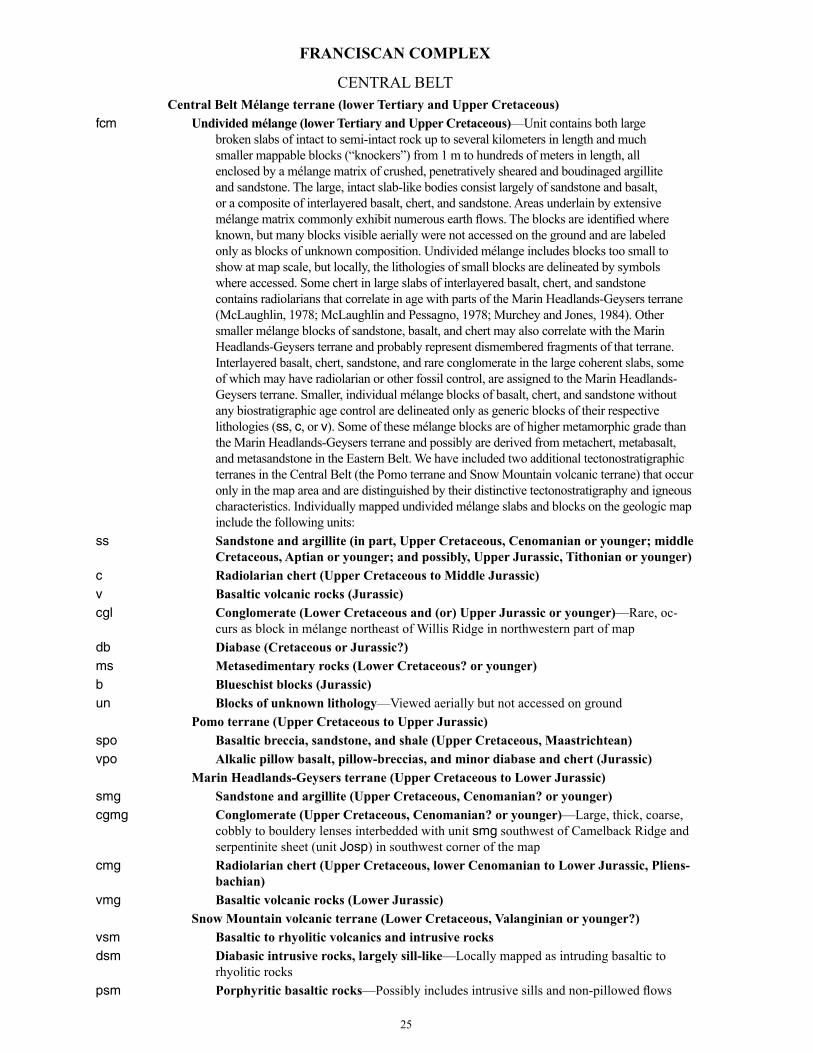
FRANCISCAN COMPLEX
CENTRAL BELT Central Belt Mélange terrane (lower Tertiary and Upper Cretaceous)fcm Undivided mélange (lower Tertiary and Upper Cretaceous)—Unit contains both large
broken slabs of intact to semi-intact rock up to several kilometers in length and much smaller mappable blocks (“knockers”) from 1 m to hundreds of meters in length, all enclosed by a mélange matrix of crushed, penetratively sheared and boudinaged argillite and sandstone. The large, intact slab-like bodies consist largely of sandstone and basalt, or a composite of interlayered basalt, chert, and sandstone. Areas underlain by extensive mélange matrix commonly exhibit numerous earth flows. The blocks are identified where known, but many blocks visible aerially were not accessed on the ground and are labeled only as blocks of unknown composition. Undivided mélange includes blocks too small to show at map scale, but locally, the lithologies of small blocks are delineated by symbols where accessed. Some chert in large slabs of interlayered basalt, chert, and sandstone contains radiolarians that correlate in age with parts of the Marin Headlands-Geysers terrane (McLaughlin, 1978; McLaughlin and Pessagno, 1978; Murchey and Jones, 1984). Other smaller mélange blocks of sandstone, basalt, and chert may also correlate with the Marin Headlands-Geysers terrane and probably represent dismembered fragments of that terrane. Interlayered basalt, chert, sandstone, and rare conglomerate in the large coherent slabs, some of which may have radiolarian or other fossil control, are assigned to the Marin Headlands-Geysers terrane. Smaller, individual mélange blocks of basalt, chert, and sandstone without any biostratigraphic age control are delineated only as generic blocks of their respective lithologies (ss, c, or v). Some of these mélange blocks are of higher metamorphic grade than the Marin Headlands-Geysers terrane and possibly are derived from metachert, metabasalt, and metasandstone in the Eastern Belt. We have included two additional tectonostratigraphic terranes in the Central Belt (the Pomo terrane and Snow Mountain volcanic terrane) that occur only in the map area and are distinguished by their distinctive tectonostratigraphy and igneous characteristics. Individually mapped undivided mélange slabs and blocks on the geologic map include the following units:
ss Sandstone and argillite (in part, Upper Cretaceous, Cenomanian or younger; middle Cretaceous, Aptian or younger; and possibly, Upper Jurassic, Tithonian or younger)
c Radiolarian chert (Upper Cretaceous to Middle Jurassic)v Basaltic volcanic rocks (Jurassic)cgl Conglomerate (Lower Cretaceous and (or) Upper Jurassic or younger)—Rare, oc-
curs as block in mélange northeast of Willis Ridge in northwestern part of mapdb Diabase (Cretaceous or Jurassic?)ms Metasedimentary rocks (Lower Cretaceous? or younger)b Blueschist blocks (Jurassic)un Blocks of unknown lithology—Viewed aerially but not accessed on ground Pomo terrane (Upper Cretaceous to Upper Jurassic)spo Basaltic breccia, sandstone, and shale (Upper Cretaceous, Maastrichtean)vpo Alkalic pillow basalt, pillow-breccias, and minor diabase and chert (Jurassic) Marin Headlands-Geysers terrane (Upper Cretaceous to Lower Jurassic)smg Sandstone and argillite (Upper Cretaceous, Cenomanian? or younger)cgmg Conglomerate (Upper Cretaceous, Cenomanian? or younger)—Large, thick, coarse,
cobbly to bouldery lenses interbedded with unit smg southwest of Camelback Ridge and serpentinite sheet (unit Josp) in southwest corner of the map
cmg Radiolarian chert (Upper Cretaceous, lower Cenomanian to Lower Jurassic, Pliens-bachian)
vmg Basaltic volcanic rocks (Lower Jurassic) Snow Mountain volcanic terrane (Lower Cretaceous, Valanginian or younger?)vsm Basaltic to rhyolitic volcanics and intrusive rocksdsm Diabasic intrusive rocks, largely sill-like—Locally mapped as intruding basaltic to
rhyolitic rockspsm Porphyritic basaltic rocks—Possibly includes intrusive sills and non-pillowed flows
25

ssm Metasandstone and argillite—Locally intercalated with volcanic rocks; lawsonite-bearing, with minor chert
EASTERN BELT Yolla Bolly terrane (Upper and Lower Cretaceous to Upper Jurassic, Tithonian)f ym Mélange of the Yolla Bolly terrane (Upper Cretaceous)—Includes the following blocks:by Blueschistcgy Conglomeratecy Metachert (Early Cretaceous, Albian or Aptian, to Middle Jurassic, Aelenian)—Also
structurally interlayered with unit vy in unit fys; inferred correlation of cy blocks to cy interlayered in fys is speculative
gy Gabbrolsy Limey mudstone—Mapped in one area of Mendocino National Forestvy Metavolcanic rocks (Middle Jurassic, Aelenian or older)—Also structurally
interlayered with unit cy in unit fys; inferred correlation of vy blocks to vy interlayered in fys is speculative
mspy Metaserpentinite blocks or lensesuny Unidentified blocksf ys Metasandstone and argillite, locally conglomeratic (Upper and Lower Cretaceous,
Cenomanian to Aptian, to Late Jurassic, Tithonian)—Rhythmically interbedded, thick- to thin-bedded, turbiditic, slaty metasandstone and argillite, reconstituted to high textural zone 1 to textural zone 2 (Blake and others, 1967), commonly displaying graded bedding. Metasandstone locally with interbedded, thin lenses of dark chert-pebble-rich metaconglomerate. Rocks generally are highly folded isoclinally, with a prominent axial planar cleavage at high to low angle to bedding. Petrographically, metasedimentary rocks that are reconstituted to textural zone 2 commonly contain neoblastic lawsonite and phengitic white mica growing parallel to platy partings and in places deformed along the parting. Very rarely, jadeitic pyroxene and (or) sodic amphibole is present in some lithic metasandstone with significant mafic igneous detritus. Structurally low, fine-grained metasedimentary rocks, reconstituted only to textural zone 1 in the Little Indian Valley area, do not contain lawsonite or other identifiable blueschist minerals; nevertheless, they still display a prominent slaty parting and have yielded numerous Lower Cretaceous and Late Jurassic (Tithonian–Valanginian) fossils (largely Buchia sp.)
cy Metachert (Lower Cretaceous, Albian to Aptian, to Middle Jurassic, Aalenian)—Red to green, tuffaceous radiolarian metachert with a prominent axial planar slaty parting, locally folded isoclinally. Overlies a thin unit of metabasaltic flows and breccias that is, in turn, faulted at the base. Analysis of radiolarians from the metachert have yielded somewhat different age relations. West of Covelo, along Hwy 162, a section of metachert studied by Isozaki and Blake (1994) was found to contain a Middle Jurassic (Aalenian) to Late Jurassic (Tithonian) fauna. Elsewhere, in the Sanhedrin Mountain area (Ohlin and others, 2010), along Hwy 20 north of Clear Lake, near Clear Lake Highlands, and near Borax Lake to the south (sheet 1), radiolarians range from Late Jurassic to Middle Cretaceous (Aptian or Albian) in Yolla Bolly terrane metacherts (this report and Ohlin and others, 2010). Although this unit is assigned the same unit symbol as metachert blocks in Mélange of the Yolla Bolly terrane (fym), direct correlation with cy blocks in unit fym is largely speculative
vy Metavolcanic rocks (Middle Jurassic, Aalenian or older)—As described in Ohlin and others (2010), mafic metavolcanic rocks of the Yolla Bolly terrane collectively mapped as greenstone include tuff, basaltic pillow flows, breccias, and diabase. In the Sanhedrin Mountain block, sparse lenses of metavolcanic rocks are locally interleaved structurally with thick lenses of metachert and metasandstone and argillite. We interpret these contacts of interleaved metasandstone, metachert, and metavolcanics rocks as probable faults. In the structurally lower part of the Sanhedrin Mountain block, adjacent to the Bartlett Springs Fault Zone, sheared lenses of tuffaceous greenstone are intersheared with lenses of conglomerate and feldspathic metasandstone. In the Hull Mountain block east of the Bartlett Springs Fault Zone, porphyritic pillow basalt and tuff are also locally present and well exposed in lower Mendenhall Creek, interlayered with metasandstone and folded at outcrop scale. Along Forest Service Road M1 north of Hull Mountain and south of Monkey Rock, a zone of metatuff is interlayered in metasandstone. The fine-grained metatuff locally contains blue sodic amphibole, light-green hornblende (edenite?), pumpellyite, and stilpnomelane, compatible with the metamorphic
26
grade of the enclosing metasandstone and argillite. Although this unit is assigned the same map symbol as blocks of metavolcanic rocks that occur in mélange of the Yolla Bolly terrane (unit f ym), the implied correlation of the metavolcanic blocks to the metavolcanic rocks interleaved with unit cy in unit f ys is highly speculative
miy Mafic intrusive rocks (Early Cretaceous)—Ohlin and others (2010) described gabbroic dikes and sills that intrude Cenomanian(?) and older metasandstone and argillite in the Hull Mountain block, near Monkey Rock, and at a locality along the Hull Mountain road 1 km to the southeast. The intrusive rocks were earlier shown to have well-preserved chilled contacts (Layman, 1977; Echeverria, 1980) and they trend northwest discontinuously for 1 km. The largest intrusive body is 20 m thick (Layman, 1977). The intrusives exhibit chilled margins and the adjacent metasandstone shows evidence of baking along contacts with metasedimentary rocks. Metamorphic minerals present in the metagabbro include lawsonite, pumpellyite, albite, sodic amphibole, carbonate minerals, stilpnomelane, chlorite, quartz, and white mica (Layman, 1977), indicating that intrusion predated blueschist-grade metamorphism
Pickett Peak terrane (Lower Cretaceous, Aptian to Barremian)fpp Undivided metasedimentary and metavolcanic rocks and metachertcpp Metachertvpp Basaltic metavolcanic rocks Mendocino Pass terrane (Lower Cretaceous, Valanginian)fmp Foliated metasandstone, argillite, and minor undivided metachert and greenstonecmp Metachert and greenstone blocks
27
References CitedBailey, E.H., Blake, M.C., Jr., and Jones, D.L., 1970, On-land
Mesozoic ocean crust in California Coast Ranges: U.S. Geological Survey Professional Paper 700–C, p. C70–C81.
Bailey, E.H., Irwin, W.P., and Jones, D.L., 1964, Franciscan and related rocks and their significance in the geology of western California: California Division of Mines and Geology Bulletin 183, 177 p.
Berkland, J.O., 1969, Late Mesozoic and Tertiary sequence near the proposed Garrett Tunnel, Mendocino and Lake Counties, California: Sacramento, Calif., U.S. Bureau of Reclamation, Region 2, unpublished file report and field sheets, 13 p.
Berkland, J.O., 1972, Paleogene “frozen” subduction zone in the Coast Ranges of northern California: International Geologic Congress, v. 24, sec. 3, p. 99–105.
Berkland, J.O., 1973, Rice Valley outlier—New sequence of Cretaceous–Paleocene strata in northern Coast Ranges, California: Geological Society of America Bulletin, v. 84, p. 2389–2406.
Berkland, J.O., 1978, Franciscan Complex-Great Valley Sequence relationships north of Clear Lake, California: American Association of Petroleum Geologists Pacific Section field trip guidebook, Castle Steam Field, p. 9–25.
Bishop, D.G., 1977, South Fork Mountain Schist at Black Butte and Cottonwood Creek, northern California: Geology, v. 55, p. 595–599.
Blake, M.C., Jr., Harwood, D.S., Helley, E.J., Irwin, W.P., Jayko, A.S., and Jones, D.L., 2000, Geologic map of the Red Bluff 30′ × 60′ quadrangle, California: U.S. Geological Survey Miscellaneous Investigations Series Map, I–2542, scale 1:100,000.
Blake, M.C., Jr., Helley, E.J., Jayko, A.S., Jones, D.L., and Ohlin, H.N., 1992, Geologic map of the Willows 1:100,000 quadrangle, California: U.S. Geological Survey Open-File Report 92–271, scale 1:100,000.
Blake, M.C., Jr., Howell, D.G., and Jones, D.L., 1982, Preliminary tectonostratigraphic terrane map of California: U.S. Geological Survey Open-File Report 82–593, 9 p., 3 sheets.
Blake, M.C., Jr., Irwin, W.P., and Coleman, R.G., 1967, Upside-down metamorphic zonation, blueschist facies, along a regional thrust in California and Oregon, in Geological Survey Research, 1967: U.S. Geological Survey Professional Paper 575–C, p. C1–C9.
Blake, M.C., Jr., and Jayko, A.S., 1983, Geologic map of the Yolla Bolly Middle Eel Wilderness and adjacent roadless areas: U.S. Geological Survey Miscellaneous Field Studies Map 1595–A, scale 1:62,500.
Blake, M.C., Jr., Jayko, A.S., Jones, D.L., and Rogers, B.W., 1987, Unconformity between Coast Range ophiolite and part of the lower Great Valley sequence, South Fork of Elder Creek, Tehama County, California, in Hill, M.L., ed., Centennial Field Guide Volume 1: Geological Society of America, Cordilleran Section, p. 279–282.
Blake, M.C., Jr., Jayko, A.S., and McLaughlin, R.J., 1985, Tectonostratigraphic terranes of northern California, in Howell, D.G., ed., Tectonostratigraphic terranes of the circum-Pacific region: Houston, Tex., Circum-Pacific Council for Energy and Mineral Resources, Earth Science Series, v. 1, p. 159–171.
Blake, M.C., Jr., Jayko, A.S., McLaughlin, R.J., and Underwood, M.B., 1988, Metamorphic and tectonic evolution of the Franciscan Complex, northern California, chap. 38 of Ernst, W.G. ed., Metamorphism and crustal evolution of the western United States (Rubey Volume VII): Englewood Cliffs, N.J., Prentice Hall, p. 1035–1060.

Blake, M.C., Jr., and Jones, D.L., 1974, Origin of Franciscan mélanges in northern California: Society of Economic Paleontologists and Mineralogists Special Publication 19, p. 345–357.
Bolt, B.A., and Oakeshott, G.B., 1982, Seismic and tectonic evaluation for Scott Dam and vicinity: San Francisco, Calif., unpublished report for Pacific Gas and Electric Company.
Brown, E.H., and Ghent, E.D., 1983, Mineralogy and phase relations in the blueschist facies of the Black Butte and Ball Rock areas, northern California Coast Ranges: American Mineralogist, v. 68, p. 365–372.
Brown, R.D., Jr., 1964, Geologic map of the Stonyford quadrangle, Glenn, Colusa and Lake Counties, California: U.S. Geological Survey Mineral Investigations Field Studies Map MF–279, scale 1:48,000, 3 pp.
Brown, R.D., Jr., Grimes, D.J., Leinz, R., Federspiel, F.E., Leszcykowsky, A.M., and Griscom, A., 1981, Mineral Resources of the Snow Mountain Wilderness Study Area, California: U.S. Geological Survey Bulletin 1495, 48 p., 2 map plates.
Bufe, C.G., Marks, S.M., Lester, F.W., Ludwin, R.S. and Stickney, M.C., 1981, Seismicity of The Geysers-Clear Lake region, in McLaughlin, R.J., and Donnelly-Nolan, J.M., eds, Research in the The Geysers-Clear Lake Geothermal area, northern California: U.S. Geological Survey Professional Paper 1141, p. 129–138.
Campbell, K.A., and Bottjer, D.J., 1995, Peregrinella; an Early Cretaceous cold-seep-restricted brachiopod: Paleobiology, v. 24, p. 461–478.
Campbell, K.A., Carlson, C., and Bottjer, D.J., 1993, Fossil cold seep limestones and associated chemosymbiotic macroinvertebrate faunas, Jurassic–Cretaceous Great Valley Group, California, in Graham, S.A., and Lowe, D.R., eds., Advances in the sedimentary geology of the Great Valley Group, Sacramento Valley, California: Los Angeles, Pacific Section of the Society of Economic Paleontologists and Mineralogists, p. 37–50.
Campbell, K.A., Farmer, J.D., and Des Marais, D., 2002, Ancient hydrocarbon seeps from the Mesozoic convergent margin of California; carbonate geochemistry, fluids and palaeoenvironments: Geofluids, v. 2, p. 63–94.
Campbell, K.A., Peterson, D., and Alfaro, A.C., 2008, Two new species of Retiskenea? (Gastropoda: Neomphalidae) from Lower Cretaceous hydrocarbon seep—carbonates of northern California: Journal of Paleontology, v. 82, p. 140–153.
Cardwell, 1965, Geology and ground water in Russian River valley areas: U.S. Geological Survey Water-Supply Paper 1548.
Carver, G.A., 1987, Late Cenozoic tectonics of the Eel River basin region, coastal northern California, in Schymiczek, H., and Suchland, R., eds, Tectonics, sedimentation, and evolution of the Eel River and coastal basins of northern California: San Joaquin Geological Society Miscellaneous Publication 37, p. 61–72.
CDWR, 1966, Engineering geology of Dos Rios-Grindstone Tunnel: California Department of Water Resources, unpublished office report.
CDWR, 1968, Areal geology Hayshed-Grindstone and Elk-Grindstone tunnels: California Department of Water Resources, unpublished map.
CDWR, 1969, Areal geology, Elk Creek tunnel: California Department of Water Resources, unpublished office report.
Chapman, A.D., Kidder, S., Saleeby, J.B., and Ducea, M.N., 2010, Extrusion of the Rand and Sierra de Salinas schists in Late Cretaceous extension and rotation of the southern Sierra Nevada and vicinity: Tectonics, v. 29, TC5006, https://doi.org/10.1929/2009TC002597.
28
Chapman, A.D., Saleeby, J.B., Wood, D.J., Piasecki, A., Kidder, S., Ducea, M.N., and Farley, K.A., 2012, Late Cretaceous gravitational collapse of the southern Sierra Nevada batholith, California: Geosphere, v. 8, p. 314–341, https://doi.org/10.1130/GES00740.1.
Clark, S.G., 1940, Geology of the Covelo District, Mendocino County, California: University of California Department of Geology Bulletin, v. 82, p. 119–142.
Clarke, S.H., Jr., 1990, Map showing geologic structures of the northern California continental margin: U.S. Geological Survey Miscellaneous Field Studies Map MF–2130, scale 1:250,000.
Clarke, S.H., Jr., and Carver, G.A., 1992, Late Holocene tectonics and paleoseismicity, southern Cascadia subduction zone: Science, v. 255, p. 188–192.
Coleman, R.G., and Lanphere, M.A., 1971, Distribution and age of the high-grade blueschists, associated eclogites, and amphibolites from Oregon and California: Geological Society of America Bulletin, v. 82, p. 2397–2412.
Colgan, J.P., McPhee, D.K., McDougall, Kristin, and Hourigan, J.K., 2012, Superimposed extension and shortening in the southern Salinas Basin and La Panza Range, California; A guide to Neogene deformation in the Salinian block of the central California Coast Ranges: Lithosphere, v. 4, no. 5, p. 411–429; GSA Data Repository Item 2012244; https://doi.org/10.1130/L208.1.
DePolo, C.M., and Ohlin, H.N., 1984, The Bartlett Springs Fault Zone—An eastern member of the California plate boundary system: Geological Society of America, Abstracts with Programs, v. 16, no. 6, p. 486.
Dickinson, W.R., Ingersoll, R.V., and Graham, S.A., 1979, Paleogene sediment dispersal and paleotectonics in northern California: Geological Society of America Bulletin, v. 90, p. 1458–1528, https://doi.org/10.1130/GSAB-P2-90-1458.
Donnelly-Nolan, J.M., Hearn, B.C., Jr., Curtis, G.H., and Drake, R.E., 1981, Geochronology and evolution of the Clear Lake volcanics: U.S. Geological Survey Professional Paper 1141, p. 47–60.
Dumitru, T.A., Ernst, W.G., Hourigan, J.K., and McLaughlin, R.J., 2015, Detrital zircon U-Pb reconnaissance of the Franciscan subduction complex in northwestern California: International Geology Review, v. 57, no. 5–8, p. 767–800, https://doi.org/10.1080/00206814.2015.1008060.
Dumitru, T.A., Wakabayashi, J., and Wright, J.E., 2009, Time-varying accretion, nonaccretion, and high-pressure metamorphism in the Franciscan subduction complex, from the initiation of subduction until ca. 80 Ma: Geological Society of America Abstracts with Programs, v. 41, no.7, p. 404.
Dumitru, T.A., Wright, J.E., Wakabayashi, J., and Wooden, J.L., 2010, Early Cretaceous transition from nonaccretionary behavior to strongly accretionary behavior within the Franciscan subduction complex: Tectonics, v. 29, TC5001, https://doi.org/10.1029/2009TC002542.
Eberhart-Phillips, D., 1988, Seismicity in the Clear Lake area, California, 1975–1983, in Sims, J.D., ed., Late Quaternary climate tectonism and sedimentation in Clear Lake, northern California Coast Ranges: Geological Society of America Special Paper 214, p. 195–206.
Echeverria, L.M., 1980, Oceanic basaltic magmas in accretionary prisms—The Franciscan intrusive gabbros: American Journal of Science, v. 280, p. 697–724.
Ernst, W.G., 1971, Petrologic reconnaissance of Franciscan metagraywackes from the Diablo Range, central California Coast Ranges: Journal of Petrology, v. 12, p. 413–437, https://doi.org/10.1093/petrology/12.2.413.
Ernst, W.G., and McLaughlin, R.J., 2012, Mineral parageneses, regional architecture, and tectonic evolution of Franciscan metagraywackes, Cape Mendocino-Garberville-Covelo 30° × 60° quadrangles, northwest California: Tectonics, v. 31, TC1001, https://doi.org/10.1029/2011TC002987V.E.
Ernst, W.G., Seki, Y., Onuki, H., and Gilbert, M.C., 1970, Comparative study of low-grade metamorphism in the California Coast Ranges and Outer Metamorphic Belt of Japan: Geological Society of America Memoir 124, 276 p.
Etter, S.D., 1979, Geology of the Lake Pillsbury area, northern Coast Ranges: Austin, University of Texas, Ph.D. dissertation, 275 p.
Gabb, W.M., 1869, Cretaceous and Tertiary fossils: Palaeontology, v. II., Geological Survey of California, p. 1–299.
Gaines, J.M., 2008, Fluvial strath terrace formation and soil development with tectonic implications along Cache Creek, California: Arcata, Calif., Humboldt State University, M.S. thesis, 113 p.
Geomatrix Consultants, 1986, Final report, geological assessment of the seismic potential of the Bartlett Springs shear zone for Scott Dam, Lake County, California: San Francisco, unpublished report for Pacific Gas and Electric Company.
Ghent, E.D., 1965, Glaucophane-schist facies metamorphism in the Black Butte area, northern Coast Ranges, California: American Journal of Science, v. 263, no. 5, p. 385–400.
Godfrey, N.J., 1997, Ophiolitic basement to the Great Valley forearc basin, California, from seismic and gravity data; Implications for crustal growth at the North American continental margin: Geological Society of America Bulletin, v. 108, no. 12, p. 1536–1562.
Graymer, R.W., Jones, D.L., and Brabb, E.E., 2002a, Geologic map and database of northeastern San Francisco Bay Region, California: U.S. Geological Survey Miscellaneous Field Studies Map MF–2403, scale 1:100,000, 28 p.
Graymer, R.W., Sarna-Wojcicki, A.M., Walker, J.P., McLaughlin, R.J., Fleck, R.J., 2002b, Controls on timing and amount of right-lateral offset on the East Bay fault system, San Francisco Bay region, California: Geological Society of America Bulletin, v. 114, no. 12, p. 1471–1479.
Hagstrum, J.T., and Murchey, B.L., 1993, Deposition of Franciscan Complex cherts along the paleoequator and accretion to the American margin at tropical paleolatitudes: Geological Society of America Bulletin v. 105, p. 766–778.
Hammersley, L., and DePaolo, D.J., 2006, Isotopic and geophysical constraints on the structure and evolution of the Clear Lake volcanic system: Journal of Volcanology and Geothermal Research, v. 153, p. 331–356.
Hayes, G.P., Johnson, C.B., and Furlong, K.P., 2006, Evidence for melt injection in the crust of northern California?: Earth and Planetary Science Letters, v. 248, p. 638–649, https://doi.org/10.1016/j.epsl.2006.05.008.
Hearn, B.C., Jr., Donnelly-Nolan, J.M., and Goff, F.E., 1995, Geologic map and structure sections of the Clear Lake volcanics, northern California: U.S. Geological Survey Miscellaneous Investigation Series I–2362, scale 1:24,000.
Hearn, B.C., Jr., McLaughlin, R.J., and Donnelly-Nolan, J.M., 1988, Tectonic framework of the Clear Lake basin, California, in Sims, J.D., ed., Late Quaternary climate, tectonism, and sedimentation in Clear Lake, northern California Coast Ranges: Geological Society of America Special Paper 214, p. 9–20.
Hepper, Kristin, 2004, A new hydrocarbon seep locality in the Mesozoic Great Valley Group, Guenoc Ranch, northern California: San Francisco State University, unpublished M.S. thesis, 154 p.
Herd, D.G., 1978, Intracontinental plate boundary east of Cape Mendocino, California: Geology, v. 6, p. 721–725.
Holway, R.S., 1914, Apparent limits of former glaciation in the northern coast ranges of California: Geological Society of America Abstracts with Programs, v. 25, p. 120–121.
Hopson, C.A., Mattinson, J.M., and Pessagno, E.A., Jr., 1981, Coast Range ophiolite, western California, in Ernst, W.G., ed., The geotectonic development of California, Rubey Volume I: Englewood Cliffs, N.J., Prentice-Hall, p. 418–510.
Hopson, C.A., Mattinson, J.M., Pessagno, E.A., Jr., and Luyendyk, B.P., 2008, California Coast Range ophiolite; Composite Middle and Late Jurassic oceanic lithosphere, in Wright, J.E., and Shervais, J.W., eds, Ophiolites, arcs, and batholiths—A tribute to Cliff Hopson: Geological Society of America Special Paper 438, p. 1–101, https://doi.org/10.1130/2008.2438(01).
Irwin, W.P., 1960, Geologic Reconnaissance of the northern Coast Ranges and Klamath Mountains, California: California Division of Mines Bulletin 179, 80 p., map plate, scale 1: 500,000.
Irwin, W.P., Wolfe, E.W., Blake, M.C., Jr., and Cunningham, C.G., Jr., 1974, Geologic map of the Pickett Peak quadrangle, Trinity County, California: U.S. Geological Survey Geologic Quadrangle Map GQ–1111, scale 1:62,500.
Isozaki, Y., and Blake, M.C., Jr., 1994, Biostratigraphic constraints on formation and timing of accretion in a subduction complex—An example from the Franciscan Complex of northern California: Journal of Geology, v. 102, p. 283–296.
Jachens, R.C., Griscom, Andrew, and Roberts, C.W., 1995, Regional extent of Great Valley basement west of the Great Valley, California; Implications for extensive tectonic wedging in the California Coast Ranges: Journal of Geophysical Research, v. 100, no. B7, p. 12769–12790.
Jayko, A.S., 1984, Structure and deformation of the eastern Franciscan belt, northern California: Santa Cruz, University of California, Ph.D. dissertation, 206 p.
Jayko, A.S., Blake, M.C., Jr., and Harms, Tekla, 1987, Attenuation of the Coast Range ophiolite by extensional faulting and nature of the Coast Range “thrust,” California: Tectonics, v. 6, p. 475–488.
Jayko, A.S., Blake, M.C., Jr., McLaughlin, R.J., Ohlin, H.N., Ellen, S.D., and Kelsey, H., 1989, Reconnaissance geologic map of the Covelo 30- by 60-minute quadrangle, northern California: U.S. Geological Survey Miscellaneous Field Studies Map MF–2001, scale 1:100,000, http://ngmdb.usgs.gov/Prodesc/proddesc_327.htm.
Jennings, C.W., 1977, Geologic map of California, updated version, 2010, Guttierrez, C., Bryant, W., Saucedo, G. and Wills, C., compilers: California Geological Survey, scale 1:750,000.
Jennings, C.W., and Strand, R.G., 1960, Geologic map of Ukiah quadrangle, California: California Division of Mines and Geology Regional Geologic Map Series, scale, 1:250,000.
29

Jones, D.E., Bailey, E.H., and Imlay, R.W., 1969, Structural and stratigraphic significance of the Buchia zones in the Colyear Springs-Paskenta area, California: U.S. Geological Survey Professional Paper 647–A, p. 1–24.
Kiel, S., and Campbell, K.A., 2005, Lithomphalus enderlini gen. et sp. nov. from cold-seep carbonates in California—A Cretaceous neomphalid gastropod?: Palaeogeography, Palaeoclimatology, Palaeoecology, v. 227, p. 232–241.
Kiel, S., Campbell, K.A., Elder, W.P., and Little, C.T.S., 2008, Jurassic and Cretaceous gastropods from hydrocarbon seeps in forearc basin and accretionary prism settings, California: Acta Palaeontologica Polonica, v. 53, no. 4, p. 679–703.
Kiel, S., Glodny, J., Birgel, D., Bulot, L.G., Campbell, K,A,, Gaillard, C., Graziano, R., Kaim, A., Lazar, I., Sandy, M.Rl, and Peckmann, J., 2014, The paleoecology, habitats, and stratigraphic range of the enigmatic Cretaceous brachiopod Peregrinella: PLos ONE, v. 9, no.10:e109260. https://doi.org/10.1371/journal.pone0109260.
Koski, R.A., Lamons, R.C., Dumoulin, J.A., and Bouse, R.M., 1993, Massive sulfide metallogenesis at a late Mesozoic sediment-covered spreading axis—Evidence from the Franciscan Complex and contemporary analogues: Geology, v. 21, p. 137–140, https://doi.org/10.1130/0091-7613(1993)021<0137:MSMAAL>2.3.CO;2.
Langenheim, V.E., Jachens, R.C., Morin, R.L. and McCabe, C.A., 2007, Preliminary gravity and magnetic data of the Lake Pillsbury region, northern Coast Ranges, California: U.S. Geological Survey Open-File Report 2007–1368, 22 p.
Langenheim, V.E., Jachens, R.C., Wentworth, C.M., and McLaughlin, R.J., 2011, Aeromagnetic and aeromagnetic-based geologic maps of the Coastal Belt, Franciscan Complex, northern California: U.S. Geological Survey Scientific Investigations Map 3188, pamphlet 20 p., 3 sheets, scales 1:100,000 and 1:250,000, and database, available at http://pubs.usgs.gov/sim/3188/.
Lanphere, M.A., 1971, Age of the Mesozoic oceanic crust in the California Coast Ranges: Geological Society of America Bulletin, v. 82, p. 3209–3211.
Lanphere, M.A., Blake, M.C., Jr., and Irwin, W.P., 1978, Early Cretaceous metamorphic age of the South Fork Mountain Schist in the northern Coast Ranges of California: America Journal of Science, v. 278, p. 798–815.
Lawton, J.E., 1956, Geology of the north half of the Morgan Valley quadrangle and the south half of the Wilbur Springs quadrangle, California: Stanford, Calif., Stanford University, Ph.D. dissertation, 223 p.
Layman, E.B., 1977, Intrusive rocks in the near-trench environment—Two localities in the northern California Franciscan complex: Stanford, Calif., Stanford University, M.S. thesis, 55 p.
Lehman, D.H., 1974, Structure and petrology of the Hull Mountain area, northern California Coast Ranges: Austin, University of Texas, Ph.D. dissertation, 126 p.
Lienkaemper, J.J., 2010, Recently active traces of the Bartlett Springs Fault, California; A Digital Database: U.S. Geological Survey Data Series 541, version 1.0, http://pubs.usgs.gov/ds/541/.
Lienkaemper, J.J., DeLong, S., McPherson, R.C., Mielke, J., Avdievitch, N., Pickering, A., and Lloyd, C., 2014, Characterizing recent slip on the Kuikui Fault, a link between the Green Valley and Bartlett Springs Fault Zones, Wilson Valley, northern California: American Geophysical Union, Fall Meeting, abstract T41C-4665.
Lozos, J.C., Harris, R.A., Murray, J.R., and Lienkaemper, J.J., 2015, Dynamic rupture models of earthquakes on the Bartlett Springs Fault, northern California: Geophysical Research Letters, v. 42, p. 4343–4349, https://doi.org/10.1002/2015GL063802.
Macpherson, G.J., 1983, The Snow Mountain Volcanic Complex—On-land seamount in the Franciscan terrain, California: Journal of Geology, v. 91, p. 73–92.
Macpherson, G.J., and Phipps, S.P., 1988, Geochemistry and petrology of mafic volcanic rocks from olistostromes in the basal Great Valley Group, northern California Coast Ranges: Geological Society of America Bulletin, v. 100, no. 11, p. 1770–1779, https://doi.org/10.1130/0016-7606(1988)100<1770:GAPOMV>2.3.CO;2.
Mattinson, J.M., and Echeverria, L.M., 1980, Ortigalita Peak gabbro, Franciscan complex—U-Pb dates of intrusion and high-pressure low-temperature metamorphism: Geology, v. 8, p. 589–593.
McFarland, F.S., Lienkaemper, J.J., and Caskey, S.J., 2016, Data from theodolite measurements of creep rates on San Francisco Bay Region faults, California: U.S. Geological Survey Open-File Report 2009–1119, ver. 1.8, 21 p. and data files, accessed September 24, 2018, at https://pubs.usgs.gov/of/2009/1119.
McLaren, M.K., Wooddell, K.E., Page W.D., van der Elst, N., Stanton, M.A., and Walter, S.R., 2007, The McCreary Glade earthquake sequence—Possible reactivation of ancient structures near Lake Pillsbury, northern Coast Ranges, Mendocino County, California: Eos, Transactions of the American Geophysical Union, v. 88, no. 52, Fall Meeting Supplement, abstract S21A-0245.
McLaughlin, R.J., 1978, Preliminary geologic map and structural sections of the central Mayacmas Mountains and The Geysers steam field, Sonoma, Lake, and Mendocino Counties, California: U.S. Geological Survey Open-File Map 78-389, scale 1:24,000, with structure sections and explanation, 2 sheets.
McLaughlin, R.J., Blake, M.C., Jr., Griscom, A., Blome, C.D., and Murchey, B., 1988, Tectonics of formation, translation, and dispersal of the Coast Range ophiolite of California: Tectonics, v. 7, no. 5, p. 1033–1056.
McLaughlin, R.J., Campbell, K.A. Lienkaemper, J.J., Graymer, R.W., Moring, B.C, Ohlin, H.N., and Enderlin, D.A., 2010, Long term displacement across the Bartlett Springs Fault Zone—Implications for evolution of the east San Francisco Bay Fault System and structural hooks in the northern Coast Ranges, California: Geological Society of America Abstracts with Programs, v. 42, no. 5, p. 478, https://gsa.confex.com/gsa/2010AM/finalprogram/abstract_177965.htm.
McLaughlin, R.J., Colgan, J.P., Elder, W.P., Enderlin, D.A., Dumitru, T.A., and Holm-Denoma, C., 2016, Maximum depositional ages and provenance from detrital zircons compared to paleontologic ages and implications for deformation timing, Lower Great Valley Sequence, Knoxville to Lake Berryessa, west of Sacramento Valley, CA: Geological Society of America Abstracts with Programs, v. 48, no. 4, https://doi.org/10.1130/abs/2016CD-27421.
McLaughlin, R.J., Ellen, S.D., Blake, M.C., Jr., Jayko, A.S., Irwin, W.P., Aalto, K.R., Carver, G.A., and Clarke, S.H., Jr., 2000, Geology of the Cape Mendocino, Eureka, Garberville, and southwestern part of the Hayfork 30- × 60-minute quadrangles and adjacent offshore area, northern California: U.S. Geological Survey Miscellaneous Field Studies Map MF–2336, scale 1:100,000, 6 sheets including maps, explanation, cross sections, pamphlet, http://geopubs.wr.usgs.gov/map-mf/mf2336/.
30

McLaughlin, R.J., and Moring, B.A., 2013, The Bartlett Springs Fault Zone—Long term multi-episodic deformation of an early Tertiary synformal down-warp in the northern California Coast Ranges: Geological Society of America Abstracts with Programs, v. 45, no. 7, p. 167.
McLaughlin, R.J., and Ohlin, H.N., 1984, Tectonostratigraphic framework of the Geysers-Clear Lake region, California, in Blake, M.C., Jr., ed., Franciscan geology of northern California: Pacific section, Society of Economic Paleontologists and Mineralogists, v. 43, p. 221–254.
McLaughlin, R.J., Ohlin, H.N., and Thormahlen, D.J., 1990, Geologic map and structure sections of the Little Indian Valley-Wilbur Springs geothermal area, northern Coast Ranges, California: U.S. Geological Survey Miscellaneous Investigations Map I–1706, scale 1:24,000, structure sections, explanation and interpretive text (2 sheets).
McLaughlin, R.J., and Pessagno, E.A., Jr., 1978, Significance of age relations above and below Upper Jurassic ophiolite in the Geysers-Clear Lake region, California: U.S. Geological Survey Journal of Research, v. 6, p. 715–726.
McLaughlin, R.J., Sliter, W.V., Sorg, D.H., and Russell, P.C., 1996, Large-scale right-slip displacement on the East San Francisco Bay Region fault system, California—Implications for location of late Miocene to Pliocene Pacific plate boundary: Tectonics, v. 15, no. 1, p. 1–18.
McPeak, A.J., Cloos, M., and Stockli, D.F., 2015, Seamount arrival into the Franciscan subduction complex at 100 Ma, Marin Headlands, San Francisco Bay, California: Geological Society of America Abstracts with Programs, v. 47, no. 4, p. 45.
Mertz, D.F., Weinrich, A.J., Sharp, W.D., and Renne, P.R., 2001, Alkaline intrusions in a near-trench setting, Franciscan Complex, California—Constraints from geochemistry, petrology and 40Ar/39Ar chronology: American Journal of Science, v. 301, p. 877–911, https://doi.org/10.2475/ajs.301.10.877.
Metro Engineering, 2011, California ARRA lidar: Open Topography, https://doi.org/10.5069/G9H70CRD.
Moore, D.E., McLaughlin, R.J., and Lienkaemper, J.J., 2015, Serpentinite in a creeping trace of the Bartlett Springs Fault, northern California: Geological Society of America Abstracts with Programs, v. 47, p. 774.
Moore, D.E., Rymer, M.J., McLaughlin, R.J., and Lienkaemper, J.J., 2011, Mineralogy of faults in the San Andreas System that are characterized by creep: American Geophysical Union, 2011 Fall Meeting, San Francisco, Calif., abstract V11A-2504 poster.
Murchey, B.L., 1984, Biostratigraphy and lithostratigraphy of chert in the Franciscan Complex, Marin Headlands, California, in Blake, M.C., Jr., ed., Franciscan geology of northern California: Society of Economic and Paleontologists and Mineralogists, Pacific Section, v. 43, p. 51–70.
Murchey, B.L., and Jones, D.L., 1984, Age and significance of chert in the Franciscan Complex, in the San Francisco region, in Blake, M.C., Jr., ed., Franciscan geology of northern California: Pacific Section Society of Economic Paleontologists and Mineralogists, Book 43, p. 23–30
Murray, J.R., Minson, S.E., and Svarc, J.L., 2014, Slip rates and spatially variable creep on faults of the northern San Andreas system inferred through Bayesian inversion of Global Positioning System data: Journal of Geophysical Research, Solid Earth, v. 119, p. 6023–6047, https://doi.org/10.1002/2014JB010966.
Nilsen, T.H., and Clarke, S.H., Jr., 1989, Late Cenozoic basins of northern California: Tectonics, v. 8, no. 6, p. 1137–1158.
Ohlin, H.N., McLaughlin, R.J., Moring, B.C., and Sawyer, T.L., 2010, Geologic map of the Bartlett Springs Fault Zone in the vicinity of Lake Pillsbury and adjacent areas of Mendocino, Lake, and Glenn Counties, California: U.S. Geological Survey Open-File Report 2010–1301, scale 1:30,000, 32 p., http://pubs.usgs.gov/of/2010/1301/.
Pessagno, E.A., Jr., 1977, Upper Jurassic radiolaria and radiolarian biostratigraphy of the California Coast Ranges: Micropaleontology, v. 23, p. 56–113.
Pitt, A.M., Hill, D.P., Walter, S.W., and Johnson, M.J.S., 2002, Midcrustal, long-period earthquakes beneath northern California volcanic areas: Seismological Research Letters, v. 73, no. 2, p. 144–152.
Platt, J.P., 1986, Dynamics of orogenic wedges and the uplift of high-pressure metamorphic rocks: Geological Society of America Bulletin, v. 97, p. 1037–1053.
Raymond, L.A., 2014, Designating tectonostratigraphic terranes versus mapping rock units in subduction complexes; perspectives from the Franciscan Complex of California, USA: International Geology Review, v. 57, p. 801–823, https://doi.org/10.1080/00206814.2014.911124.
Richmond, J.A., 2005, New paleontological data for Great Valley Group sediments in the Guenoc Ranch area, Lake County, California: Geological Society of America, Abstracts with Programs, v. 37, no. 4, p. 42.
Robertson, A.H.F., 1990, Sedimentology and tectonic implications of ophiolite-derived clastics overlying the Jurassic Coast Range ophiolite, northern California: American Journal of Science, v. 290, no. 2, p. 109–163.
Rymer, M.J., 1981, Stratigraphic revision of the Cache Formation (Pliocene and Pleistocene), Lake County, California: U.S. Geological Survey Bulletin 1502–C, 35 p.
Saleeby, J., 2003, Segmentation of the Laramide slab—Evidence from the southern Sierra Nevada region: Geological Society of America Bulletin, v. 115, p. 655–668, https://doi.org/10.1130/0016-7606(2003)115<0655:SOTLSF>2.0.CO;2.
Shervais, J.W., Choi, S.H., Sharp, W.D., Ross, J., Zoglman-Schuman, M., and Mukasa, S.B., 2011, Serpentinite matrix mélange—Implications of mixed provenance for mélange formation, in Wakabayashi, J., and Dilek, Y., eds., Mélanges—Processes of Formation and Societal Significance: Geological Society of America Special Paper 480, p. 1–30, https://doi.org/10.1130/2011.2480(01).
Shervais, J.W., Murchey, B.L., Kimbrough, D.L., Renne, P.R., and Hanan, B.B., 2005a, Radioisotopic and biostratigraphic age relations in the Coast Range ophiolite of northern California—Implications for the tectonic evolution of the Western Cordillera: Geological Society of America Bulletin, v. 117, no. 5–6, p. 633–653.
Shervais, J.W., Zoglman Schuman, M.M., and Hanan, B.B., 2005b, The Stonyford Volcanic Complex; a forearc seamount in the northern California Coast Ranges: Journal of Petrology, v. 46, no. 10, p. 2091–2128, https://doi.org/10.1093/petrology/egi048.
Sibson, R.H., 1985, Stopping of earthquake ruptures at dilatational fault jogs: Nature, v. 316 no. 6025, p. 248–251.
31

Sims, J.D., Adam, D.P., and Rymer, M.J., 1981, Stratigraphy and palynology of Clear Lake, California, in McLaughlin, R.J., and Donnelly-Nolan, J., eds., Research in the Geysers-Clear Lake geothermal area, northern California: U.S. Geological Survey Professional Paper 1141, p. 219–230.
Sims, J.D., and Rymer, M.J., 1976, Map of gaseous springs and associated faults in Clear Lake, California: U.S. Geological Survey Miscellaneous Field Investigations Map MF–721, scale 1:48,000.
Slowey, A.J., and Rytuba, J.J., 2008, Mercury release from the Rathburn Mine, Petray Mine, and Bear Valley saline springs, Colusa County, California 2004–2006: U.S. Geological Survey Open-File Report 2008–1179, 49 p.
Stanford, J.E., 1991, Geology of the Franciscan Complex Central Belt between Redwood Valley and Potter Valley, Mendocino County, California: Hayward, California State University, M.S. thesis, 149 p., 2 map plates.
Stanton, T.W., 1895, Contributions to the Cretaceous paleontology of the Pacific coast; the fauna of the Knoxville beds: U.S. Geological Survey Bulletin 133, p. 1–132.
Stinson, M.C., 1957, Geology of the Island Mountain Copper Mine, Trinity County, California: California Journal of Mines and Geology, v. 53, p. 9–33.
Suppe, John, 1973, Geology of the Leech Lake Mountain-Ball Mountain region, California: University of California Publications in Geological Sciences, v. 107, p. 1–81.
Suppe, John, 1979, Cross section of the southern part of the northern Coast Ranges and Sacramento Valley, California: Geological Society of America Map and Chart Series, MC–28B.
Suppe, John, and Armstrong, R.L., 1972, K-Ar dating of Franciscan metamorphic rocks: American Journal of Science, v. 272, p. 217–233.
Suppe, John, and Foland, K.A., 1978, The Goat Mountain Schists and Pacific Ridge Complex—A redeformed but still-intact late Mesozoic Franciscan schuppen complex, in Howell, D.G., and McDougall, Kristen, eds., Mesozoic paleogeography of the western United States: Society of Economic Paleontologists and Mineralogists, Pacific Section, Pacific Coast Paleogeography Symposium 2, p. 431–451.
Surpless, K.D., Graham, S.A., Covault, J.A., and Wooden, J.L., 2006, “Does the Great Valley Group contain Jurassic strata?” Reevaluation of the age and early evolution of a classic forearc basin: Geology, v. 34, p. 21–24, https://doi.org/10.1130/G21940.1.
Swe, Win, 1968, Stratigraphy and structure of late Mesozoic rocks south and southeast of Clear Lake, California: Stanford, Calif., Stanford University, unpublished Ph.D. dissertation, 75 p., 4 tables, 12 figures, 3 plates.
Swe, Win, and Dickinson, W.R., 1970, Sedimentation and thrusting of late Mesozoic rocks in the Coast Ranges near Clear Lake, California: Geological Society of America Bulletin, v. 81, no. 12, p. 3513–3536.
Thomas, A.M., Bergmann, R., and Dreger, D.S., 2013, Incipient faulting near Lake Pillsbury, California, and the role of accessory faults in plate boundary evolution: Geology, v. 41, no. 10, p. 1123–1126, https://doi.org/10.1130/G34588.1.
U.S. Geological Survey Geologic Names Committee, 2010, Divisions of geologic time—major chronostratigraphic and geochronologic units: U.S. Geological Survey Fact Sheet 2010–3059, 2 p.
Wagner, D.L., and Bortugno, E.B., 1982, Geologic map of the Santa Rosa quadrangle: California Division of Mines and Geology Regional Geologic Map Series Map 2A, scale 1:250,000.
Waldhauser, Felix, and Engebreth, Ben, 2017, Real-time double-difference earthquake locations for northern California [database]: U.S. Geological Survey National Earthquake Reduction Program (NEHRP) and Lamont-Doherty Earth Observatory (LDEO), accessed August 2016 and downloaded February 2017 from http://ddrt.ldeo.columbia.edu.
Waldhauser, F., and Schaff, D.P., 2008, Large-scale relocation of two decades of northern California seismicity using cross-correlation and double-difference methods: Journal of Geophysical Research, v. 113, no. B08311, https://doi.org/10.1029/2007JB005479.
Wentworth, C.M., Blake, M.C., Jr., Jones, D.L., Walter, A.W., and Zoback, M.D., 1984, Tectonic wedging associated with emplacement of the Franciscan assemblage, California Coast Ranges, in Blake, M.C., Jr., ed., Franciscan geology of northern California: Pacific Section, Society of Economic Paleontologists and Mineralogists Book 43, p. 163–173.
Wentworth, C.M., Blake, M.C., Jr., McLaughlin, R.J., and Graymer, R.W., 1999, Preliminary geologic map of the San Jose 30- × 60-minute quadrangle, California—A digital database: U.S. Geological Survey Open-File Report 98–795, scale 1:100,000, 2 plates, interpretive geologic map pamphlet 52 p., database pamphlet 13 p., map database, text files.
Wentworth, C.M., and Zoback, M.D., 1990, Structure of the Coalinga region and thrust origin of the earthquake, in Rymer, M.J., and Ellsworth, W.L., eds, The Coalinga earthquake of May 2, 1983: U.S. Geological Survey Professional Paper 1487, p. 41–68.
Worrall, D.M., 1981, Imbricate low-angle faulting in uppermost Franciscan rocks, south Yolla Bolly area, northern California: Geological Society of America Bulletin, v. 92, p. 703–729, https://doi.org/10.1130/0016-7606(1981)92<703:ILFIUF>2.0.CO;2.
32

33
Figure 14. Map showing locations and locality numbers of fossils listed in table 1 (https://doi.org/10.3133/sim3395) and plotted on the geologic map (sheet 1). The geology is shown in grayscale to provide a context for locating the fossil occurrences on the geologic map. Where fossil localities are numerous and closely spaced, locality numbers may be grouped. Some specific fossil localities or groups of localities cited in the text discussion are also labeled on the map.
19
1-18
20-21 22-23
24
28
29
30
2526-27
33
3536,40 38-39
41,45-46,48,57
60,62,69
43-44
61,6463,65-67,70
3147,52-54
49-51,56,59
80
68,7173
81
3234
37 42
92 95-97100,102
99101
113104,107-112
114,116,118,120,123
87
88
90 9193
94 98
76-78
8485
86
7274
7579
82
83
133
140162,163
166167
168-172,174-190
134-143,145-161
173
164-165
129-132
115,117,119,121,125-127
89
103 105,106
Round Valley
Wilbur Springs
Lower Lake
BoraxLake
Little Indian Valley
Stonyford
Snow Mountain
Lake Pillsbury
Pomoterrane
EstellCreek
RiceValley
ClearLake

Tabl
e 1.
Pa
leon
tolo
gica
l dat
a fro
m T
ertia
ry a
nd M
esoz
oic
rock
s of
the
map
are
a fro
m R
ound
Val
ley
to W
ilbur
Spr
ings
, nor
ther
n Co
ast R
ange
s, C
alifo
rnia
. Fig
ure
14 s
how
s th
e fo
ssil
loca
litie
s on
a p
age-
size
figu
re in
gra
ysca
le, t
o he
lp th
e us
er fi
nd fo
ssil
loca
litie
s on
the
map
(she
et 1
). So
me
loca
litie
s of
Mes
ozoi
c fo
ssils
that
plo
t on
the
geol
ogic
map
with
in o
r su
rrou
nded
by
Quat
erna
ry d
epos
its a
re in
isol
ated
are
as o
f bed
rock
und
erly
ing
allu
vium
that
are
too
limite
d to
sho
w a
t the
sca
le o
f the
geo
logi
c m
ap (f
or e
xam
ple,
sm
all b
edro
ck
win
dow
s in
stre
am b
otto
ms,
or b
edro
ck in
ters
pers
ed in
flig
hts
of g
roup
ed fl
uvia
l ter
race
s of
var
ying
age
). So
me
loca
litie
s m
ight
als
o be
ass
ocia
ted
with
Qua
tern
ary
eros
iona
l sur
face
s on
bed
rock
that
do
not i
nclu
de a
ctua
l dep
osits
and
inst
ead
are
only
geo
mor
phic
sur
face
s. W
e in
clud
e th
e co
ordi
nate
s fo
r som
e fo
ssil
loca
litie
s in
the
Fran
cisc
an C
ompl
ex a
nd G
reat
Va
lley
Com
plex
that
are
out
side
of t
he a
rea
of th
is m
ap (d
esig
nate
d as
map
no.
999
) but
are
in a
djac
ent o
r nea
rby
area
s of
the
north
ern
Coas
t Ran
ges.
Ref
er to
the
cite
d so
urce
s of
the
foss
il da
ta fo
r mor
e in
form
atio
n on
the
geol
ogy
of th
ese
area
s.
[Map
_No,
loca
tion
num
ber s
how
n on
the
geol
ogic
map
(she
et 1
) and
fig.
14,
as w
ell a
s inc
lude
d in
the
data
base
. ID
, fiel
d or
labo
rato
ry id
entifi
catio
n nu
mbe
r fro
m sa
mpl
e co
llect
or. L
at a
nd L
ong,
latit
ude
(N.)
and
long
itude
(W.).
Fos
sil a
nd a
ge, i
dent
ified
foss
ils a
nd a
ges.
Sour
ce, s
ourc
e of
foss
il da
ta. L
ith, l
ithol
ogy
of e
nclo
sing
rock
. Uni
t, lit
holo
gic
or g
eolo
gic
form
atio
nal s
ourc
e of
foss
il, w
here
kno
wn]
Map
_No.
IDLa
titud
eLo
ngitu
deFo
ssil
and
age
Sour
ceLi
thol
ogy
Uni
t
114
339
.742
0-1
23.2
809
Am
mon
ite: P
achy
disc
us; A
mm
onoi
d: N
osto
cera
s;
Mol
lusk
s: In
ocer
amus
; Upp
er C
reta
ceou
sC
lark
, 194
0Sa
ndst
one,
shal
e,
and
cong
lom
erat
e
214
439
.740
0-1
23.2
924
Am
mon
ite: P
achy
disc
us; A
mm
onoi
d: N
osto
cera
s;
Mol
lusk
s: In
ocer
amus
; Upp
er C
reta
ceou
sC
lark
, 194
0Sa
ndst
one,
shal
e,
and
cong
lom
erat
e
316
1A39
.733
2-1
23.2
775
Am
mon
ite: P
achy
disc
us; A
mm
onoi
d: N
osto
cera
s;
Mol
lusk
s: In
ocer
amus
; Upp
er C
reta
ceou
sC
lark
, 194
0Sa
ndst
one,
shal
e,
and
cong
lom
erat
e
416
139
.733
0-1
23.2
763
Am
mon
ite: P
achy
disc
us; A
mm
onoi
d: N
osto
cera
s;
Mol
lusk
s: In
ocer
amus
; Upp
er C
reta
ceou
sC
lark
, 194
0Sa
ndst
one,
shal
e,
and
cong
lom
erat
e
5~(
149,
148,
153)
39.7
293
-123
.254
6A
mm
onite
: Pac
hydi
scus
; Am
mon
oid:
Nos
toce
ras;
M
ollu
sks:
Inoc
eram
us; U
pper
Cre
tace
ous
Cla
rk, 1
940
Sand
ston
e, sh
ale,
an
d co
nglo
mer
ate
6~(
149,
150)
39.7
283
-123
.259
7A
mm
onite
: Pac
hydi
scus
; Am
mon
oid:
Nos
toce
ras;
M
ollu
sks:
Inoc
eram
us; U
pper
Cre
tace
ous
Cla
rk, 1
940
Sand
ston
e, sh
ale,
an
d co
nglo
mer
ate
714
639
.728
1-1
23.2
572
Mac
rofo
ssils
: Bra
chys
phin
gus l
irat
us G
abb;
Tur
-ri
tella
infr
agra
nula
ta G
abb;
Tel
lina
undu
lifer
a G
abb;
Eoc
ene
Cla
rk, 1
940
Sand
ston
e an
d sh
ale
8~1
0539
.726
8-1
23.2
619
Mac
rofo
ssils
: Bra
chys
phin
gus l
irat
us G
abb;
Tur
-ri
tella
infr
agra
nula
ta G
abb;
Tel
lina
undu
lifer
a G
abb;
Eoc
ene
Cla
rk, 1
940
Sand
ston
e an
d sh
ale
915
639
.726
6-1
23.2
530
Mac
rofo
ssils
: Bra
chys
phin
gus l
irat
us G
abb;
Tur
-ri
tella
infr
agra
nula
ta G
abb;
Tel
lina
undu
lifer
a G
abb;
Eoc
ene
Cla
rk, 1
940
Sand
ston
e an
d sh
ale
1089
39.7
265
-123
.260
2M
acro
foss
ils: B
rach
ysph
ingu
s lir
atus
Gab
b; T
ur-
rite
lla in
frag
ranu
lata
Gab
b; T
ellin
a un
dulif
era
Gab
b; E
ocen
e
Cla
rk, 1
940
Sand
ston
e an
d sh
ale
1185
,85A
39.7
257
-123
.262
9A
mm
onite
: Pac
hydi
scus
; Am
mon
oid:
Nos
toce
ras;
M
ollu
sks:
Inoc
eram
us; U
pper
Cre
tace
ous
Cla
rk, 1
940
Sand
ston
e, sh
ale,
an
d co
nglo
mer
ate
1215
839
.723
4-1
23.2
451
Am
mon
ite: P
achy
disc
us; A
mm
onoi
d: N
osto
cera
s;
Mol
lusk
s: In
ocer
amus
; Upp
er C
reta
ceou
sC
lark
, 194
0Sa
ndst
one,
shal
e,
and
cong
lom
erat
e
1392
,92-
139
.723
0-1
23.2
468
Mac
rofo
ssils
: Bra
chys
phin
gus l
iratu
s Gab
b; T
ur-
ritel
la in
frag
ranu
lata
Gab
b; T
ellin
a un
dulif
era
Gab
b; E
ocen
e
Cla
rk, 1
940
Sand
ston
e an
d sh
ale
34

Tabl
e 1.
—Co
ntin
ued
Map
_No.
IDLa
titud
eLo
ngitu
deFo
ssil
and
age
Sour
ceLi
thol
ogy
Uni
t
1449
39.7
221
-123
.259
5A
mm
onite
: Pac
hydi
scus
; Am
mon
oid:
Nos
toce
ras;
M
ollu
sks:
Inoc
eram
us; U
pper
Cre
tace
ous
Cla
rk, 1
940
Sand
ston
e, sh
ale,
an
d co
nglo
mer
ate
1516
839
.714
6-1
23.2
384
Mac
rofo
ssils
: Des
mos
tylu
s too
th; O
stre
a ap
pres
sa;
Ost
rea;
Nat
rica
sp.;
Cor
bicu
la (?
); P
ecte
n;
Mid
dle
(to E
arly
?) M
ioce
ne
Cla
rk, 1
940
Shal
low
mar
ine
to e
stua
rine
cong
lom
erat
e,
sand
ston
e, sh
ale,
an
d co
al
1616
9-c
39.7
126
-123
.283
7M
acro
foss
ils: D
esm
osty
lus t
ooth
; Ost
rea
appr
essa
; O
stre
a; N
atri
ca sp
.; C
orbi
cula
(?);
Pect
en;
Mid
dle
(to E
arly
?) M
ioce
ne
Cla
rk, 1
940
Shal
low
mar
ine
to e
stua
rine
cong
lom
erat
e,
sand
ston
e, sh
ale,
an
d co
al
1750
[~50
-1,5
0-3]
39.7
028
-123
.242
6M
acro
foss
ils: B
rach
ysph
ingu
s lir
atus
Gab
b; T
ur-
rite
lla in
frag
ranu
lata
Gab
b; T
ellin
a un
dulif
era
Gab
b; E
ocen
e
Cla
rk, 1
940
Sand
ston
e an
d sh
ale
1856
39.6
975
-123
.269
1M
acro
foss
ils: D
esm
osty
lus t
ooth
; Ost
rea
appr
essa
; O
stre
a; N
atri
ca sp
.; C
orbi
cula
(?);
Pect
en;
Mid
dle
(to E
arly
?) M
ioce
ne
Cla
rk, 1
940
Shal
low
mar
ine
to e
stua
rine
cong
lom
erat
e,
sand
ston
e, sh
ale,
an
d co
al
1916
439
.683
3-1
23.2
626
Mac
rofo
ssils
: Des
mos
tylu
s too
th; O
stre
a ap
pres
sa;
Ost
rea;
Nat
rica
sp.;
Cor
bicu
la (?
); P
ecte
n;
Mid
dle
(to E
arly
?) M
ioce
ne
Cla
rk, 1
940
Shal
low
mar
ine
to e
stua
rine
cong
lom
erat
e,
sand
ston
e, sh
ale,
an
d co
al
2012
039
.681
8-1
23.2
344
Mac
rofo
ssils
: Bra
chys
phin
gus l
irat
us G
abb;
Tur
-ri
tella
infr
agra
nula
ta G
abb;
Tel
lina
undu
lifer
a G
abb;
Eoc
ene
Cla
rk, 1
940
Sand
ston
e an
d sh
ale
2112
339
.681
1-1
23.2
317
Mac
rofo
ssils
: Bra
chys
phin
gus l
irat
us G
abb;
Tur
-ri
tella
infr
agra
nula
ta G
abb;
Tel
lina
undu
lifer
a G
abb;
Eoc
ene
Cla
rk, 1
940
Sand
ston
e an
d sh
ale
22M
6600
39.6
628
-122
.985
3Pe
lecy
pods
: Buc
hia
paci
fica
(Jel
etzk
y); E
arly
C
reta
ceou
s (m
iddl
e Va
lang
inia
n)C
olle
cted
by
J.C. M
axw
ell,
Uni
v. o
f Tex
as, A
ustin
, 197
6;
iden
tified
by
D.L
. Jon
es, 1
977
Shea
red
argi
llite
Fr
anci
scan
Com
-pl
ex, C
entra
l B
elt,
“Poi
son
Roc
k” m
élan
ge a
t H
ayde
n R
ock
35

Map
_No.
IDLa
titud
eLo
ngitu
deFo
ssil
and
age
Sour
ceLi
thol
ogy
Uni
t
23B
BH
-15
39.6
623
-122
.987
1R
adio
laria
: Lat
e Ju
rass
ic (T
ithon
ian)
Col
lect
ed b
y H
.N. O
hlin
; ide
nti-
fied
by C
.D. B
lom
eR
adio
laria
n ch
ert
bloc
k in
mél
ange
Fran
cisc
an C
om-
plex
, Cen
tral B
elt
(Poi
son
Roc
k m
élan
ge);
near
H
ayde
n R
ock
241
39.6
042
-122
.934
3M
ollu
sks:
Buc
hia,
Low
er C
reta
ceou
s, Va
lang
inia
nD
.L. J
ones
, in
Ohl
in a
nd o
ther
s, 20
10M
etas
ands
tone
Fran
cisc
an E
aste
rn
Bel
t, Yo
lla B
olly
te
rran
e25
M60
9039
.594
2-1
22.8
536
Pele
cypo
d: B
uchi
a; L
ate
Jura
ssic
(Tith
onia
n)
Col
lect
ed b
y C
alif.
Dep
t. of
W
ater
Res
ourc
es g
eolo
gist
s, as
list
ed in
Bla
ke a
nd Jo
nes,
1974
Mél
ange
Fran
cisc
an C
om-
plex
, Cen
tral B
elt
mél
ange
26M
6601
39.5
919
-122
.835
6Pe
lecy
pods
: Buc
hia
cf. B
. unc
itoid
es?
(Pav
low
), bi
valv
e fr
agm
ents
; Ear
ly C
reta
ceou
s (B
erria
-si
an?)
, Rad
iola
ria: s
pars
e, a
ppea
rs to
cor
rela
te
with
Ear
ly C
reta
ceou
s (up
per A
ptia
n or
low
er
Alb
ian
or y
oung
er) s
ectio
n of
Dry
Cre
ek
Mac
rofo
ssils
col
lect
ed b
y J.C
. M
axw
ell,
1976
; ide
ntifi
ed b
y D
.L. J
ones
, 197
7. R
adio
laria
re
porte
d in
D.H
. Leh
man
, 19
74 (t
able
7);
iden
tified
by
E.A
. Pes
sagn
o fr
om sa
me
loca
lity
Mac
rofo
ssils
and
ra-
diol
aria
, of m
ixed
ag
e, p
rese
nt in
th
in c
arbo
nate
be
ds a
nd c
oncr
e-tio
ns in
thin
be
dded
shal
ey
turb
idite
s in
stru
ctur
al w
indo
w
thro
ugh
Pick
ett
Peak
terr
ane
Prob
able
Gre
at
Valle
y se
quen
ce,
imbr
icat
ed b
e-tw
een
unde
rlyin
g ro
cks o
f Fra
ncis
-ca
n C
entra
l Bel
t m
élan
ge (a
nd
poss
ibly
, Eas
tern
B
elt Y
olla
Bol
ly
terr
ane)
and
ove
r-th
rust
rock
s of
Fran
cisc
an E
ast-
ern
Bel
t, Pi
cket
t Pe
ak te
rran
e27
M66
0339
.591
9-1
22.8
356
Sam
e lo
c. a
s M66
01—
Pele
cypo
d: B
uchi
a un
cito
i-de
s (Pa
vlow
); Ea
rly C
reta
ceou
s (B
erria
sian
), bu
t se
e M
6601
Col
lect
ed b
y J.C
. Max
wel
l, 19
76; i
dent
ified
by
D.L
. Jo
nes,
1977
Thin
car
bona
te b
eds
and
conc
retio
ns
in w
ell-b
edde
d sh
aley
turb
idite
s of
Est
ell C
reek
Prob
able
Gre
at V
al-
ley
sequ
ence
282
39.5
764
-122
.972
1R
adio
laria
: Par
vici
ngul
a(?)
pro
cera
, Pes
sagn
o;
Parv
icin
gula
sp.,
?Pod
ubur
sa sp
., Ps
eudo
dic-
tyom
itra
sp.;
Late
Jura
ssic
, Tith
onia
n
C.D
. Blo
me
in O
hlin
and
oth
ers,
2010
Che
rt in
mél
ange
Fran
cisc
an C
om-
plex
, Cen
tral B
elt
293
39.5
491
-122
.919
3M
ollu
sks:
Inoc
eram
us; L
ower
Cre
tace
ous,
Cen
o-m
ania
n (?
)B
lake
and
Jone
s, 19
74; c
ited
in
Ohl
in a
nd o
ther
s, 20
10M
etas
ands
tone
Fran
cisc
an E
aste
rn
Bel
t, Yo
lla B
olly
te
rran
e30
439
.530
8-1
23.0
112
Rad
iola
ria: A
rche
odic
tyom
itra
sp.,
aff.
A.si
mpl
ex
Pess
agno
; pse
udod
icty
omitr
a sp
.; Th
anar
la sp
.; Lo
wer
Cre
tace
ous,
prob
ably
Apt
ian-
Alb
ian
C.D
. Blo
me
in O
hlin
and
oth
ers,
2010
Met
asan
dsto
neFr
anci
scan
Eas
tern
B
elt,
Yolla
Bol
ly
terr
ane
36
Tabl
e 1.
—Co
ntin
ued

Map
_No.
IDLa
titud
eLo
ngitu
deFo
ssil
and
age
Sour
ceLi
thol
ogy
Uni
t
31M
R01
7139
.415
8-1
22.7
153
Rad
iola
ria: c
ones
, ver
y la
rge
squa
shed
sphe
res
with
stub
by sp
ines
; no
relia
ble
age
assi
gnm
ent
Col
lect
ed b
y R
.D. B
row
n; d
e-sc
ribed
in B
row
n an
d ot
hers
, 19
81. R
adio
laria
exa
min
ed b
y E.
A. P
essa
gno
Rad
iola
rian
cher
t at
base
of v
olca
nic-
rich
300-
to
500-
ft-th
ick
sedi
-m
enta
ry u
nit
Snow
Mou
ntai
n/St
. Jo
hn M
ount
ain
volc
anic
com
plex
of
Cen
tral B
elt
of F
ranc
isca
n C
ompl
ex32
Che
rtB39
.412
2-1
22.5
859
Rad
iola
ria: Z
ones
3-8
to 7
-10
Teth
yan
UA
Z of
B
aum
gartn
er a
nd o
ther
s 199
5; M
iddl
e an
d U
p-pe
r Jur
assi
c (lo
wer
Baj
ocia
n to
upp
er K
imm
er-
idge
an)
Col
lect
ed a
nd id
entifi
ed b
y B
.L.
Mur
chey
as r
epor
ted
in S
her-
vais
and
oth
ers,
2005
Rad
iola
rian
cher
t se
quen
ce in
St
onyf
ord
volc
a-ni
c co
mpl
ex
Ston
yfor
d vo
lcan
ic
com
plex
of C
oast
R
ange
oph
iolit
e
335
39.4
092
-122
.952
0M
ollu
sks:
Buc
hia
pioc
hii,
Late
Jura
ssic
, Tith
onia
n R
.W. I
mla
y in
W.P
. Irw
in, 1
960;
ci
ted
by O
hlin
and
oth
ers,
2010
Shal
e an
d sa
ndst
one
slab
Oph
iolit
ic m
élan
ge
34C
hertC
39.4
047
-122
.596
3R
adio
laria
: Zon
es 8
-10,
Tet
hyan
UA
Z of
B
aum
gartn
er a
nd o
ther
s 199
5; M
iddl
e to
Upp
er
Jura
ssic
(mid
dle
Cal
lovi
an-u
pper
Kim
mer
-id
gean
)
Col
lect
ed a
nd id
entifi
ed b
y B
.L.
Mur
chey
as r
epor
ted
in S
her-
vais
and
oth
ers,
2005
Rad
iola
rian
cher
t se
quen
ce in
St
onyf
ord
volc
a-ni
c co
mpl
ex
Ston
yfor
d vo
lcan
ic
com
plex
of C
oast
R
ange
oph
iolit
e
356
39.3
933
-122
.936
1M
ollu
sks:
Buc
hia
sp.,
Prob
ably
Lat
e Ju
rass
ic,
Tith
onia
n ba
sed
on p
roxi
mity
to B
. pio
chii
loc.
Ette
r, 19
79; c
ited
in O
hlin
and
ot
hers
, 201
0Sh
ale
and
sand
ston
e sl
abO
phio
litic
mél
ange
3633
39.3
791
-123
.083
8M
ollu
sks:
Pel
ecyp
ods;
Din
oflag
ella
tes;
U. C
reta
-ce
ous,
Cam
pani
an
J.O. B
erkl
and,
Cal
if. D
ept.
of
Wat
er R
esou
rces
Shal
e an
d th
ick
bed-
ded
sand
ston
e
37C
hertA
39.3
766
-122
.619
8R
adio
laria
: Zon
es 3
-6 to
6-6
, Tet
hyan
UA
Z of
B
aum
gartn
er a
nd o
ther
s 199
5; M
iddl
e Ju
rass
ic
(low
er B
ajoc
ian-
uppe
r Bat
honi
an)
Col
lect
ed a
nd id
entifi
ed b
y B
.L.
Mur
chey
as r
epor
ted
in S
her-
vais
and
oth
ers,
2005
Rad
iola
rian
cher
t se
quen
ce in
St
onyf
ord
volc
a-ni
c co
mpl
ex
Ston
yfor
d vo
lcan
ic
com
plex
of C
oast
R
ange
oph
iolit
e
3818
39.3
750
-123
.060
7M
icro
foss
ils: L
ower
Cre
tace
ous
J.O. B
erkl
and
Sand
ston
e an
d sh
ale,
th
in b
edde
d
3929
39.3
736
-123
.066
7M
icro
foss
ils: L
ower
Cre
tace
ous
Shel
l Oil
Co.
Gra
y sa
ndst
one
and
shal
e
4030
39.3
726
-123
.079
7A
rena
ceou
s for
amin
ifera
, non
diag
nost
ic
Shel
l Oil
Co.
Shal
e an
d th
ick
bed-
ded
sand
ston
e
4125
39.3
720
-123
.108
2M
ollu
sks:
oys
ters
, pec
tens
, U. C
reta
ceou
sJ.O
. Ber
klan
dVo
lcan
ic sa
ndst
one,
co
nglo
mer
ate
42C
hertD
39.3
713
-122
.603
2R
adio
laria
: Zon
es 9
-10,
Tet
hyan
UA
Z of
B
aum
gartn
er a
nd o
ther
s 199
5; U
pper
Jura
ssic
(m
iddl
e O
xfor
dian
to u
pper
Kim
mer
idge
an)
Orig
inal
ly c
olle
cted
and
de
scrib
ed b
y E.
A. P
essa
-gn
o, 1
977;
revi
sed
by B
.L.
Mur
chey
in S
herv
ais a
nd
othe
rs, 2
005
Rad
iola
rian
cher
t se
quen
ce in
St
onyf
ord
volc
a-ni
c co
mpl
ex
Ston
yfor
d vo
lcan
ic
com
plex
of C
oast
R
ange
oph
iolit
e
4319
39.3
696
-123
.047
9D
inofl
agel
late
s: A
scod
iniu
m, L
ower
Cre
tace
ous,
Alb
ian
J.O. B
erkl
and
Mas
sive
sand
ston
e an
d sh
ale
37
Tabl
e 1.
—Co
ntin
ued

Map
_No.
IDLa
titud
eLo
ngitu
deFo
ssil
and
age
Sour
ceLi
thol
ogy
Uni
t
4420
39.3
665
-123
.051
6D
inofl
agel
late
s: A
scod
iniu
m, L
ower
Cre
tace
ous,
Alb
ian
J.O. B
erkl
and
Mas
sive
sand
ston
e an
d sh
ale
4522
39.3
664
-123
.106
2A
mm
onite
: Gua
dryc
eras
, Mic
rofo
ssils
, , U
. Cre
ta-
ceou
s, M
aest
richt
ean
J.O. B
erkl
and
Volc
anic
sand
ston
e,
cong
lom
erat
e
4628
39.3
599
-123
.102
7M
ollu
sks:
Mee
kia,
U. C
reta
ceou
sJ.O
. Ber
klan
d, C
alif.
Dep
t. of
W
ater
Res
ourc
esVo
lcan
ic sa
ndst
one,
co
nglo
mer
ate
47M
4350
39.3
588
-122
.869
7Pe
lecy
pods
: Nuc
ulan
a sp
., Te
llina
?, u
ndet
. Fra
g-m
ents
; Age
inde
term
inat
eC
olle
cted
by
J.O. B
erkl
and,
19
70; i
deni
fied
by W
.O. A
ddi-
cot,
1970
Sand
ston
e in
bed
of
McL
eod
Cre
ek,
Ric
e Va
lley
Unn
amed
form
atio
n of
pre
sum
ed e
arly
Te
rtiar
y ag
e48
2339
.358
5-1
23.1
036
Mol
lusk
s: o
yste
rs, p
ecte
ns, U
. Cre
tace
ous
J.O. B
erkl
and
Volc
anic
sand
ston
e,
cong
lom
erat
e
49M
6765
39.3
558
-122
.825
6Pe
lecy
pods
: Ent
oliu
m (?
) sp;
Jura
ssic
or C
reta
-ce
ous
Col
lect
ed b
y J.
Supp
e, 1
977;
id
entifi
ed b
y D
.L. J
ones
, 197
7N
o lit
holo
gic
data
pr
ovid
edN
o in
form
atio
n
50M
6766
39.3
553
-122
.829
7Pe
lecy
pods
: Buc
hia
sp.,
stria
te fo
rm, s
ame
as
Buch
ia sp
. in
M65
64; L
ate
Jura
ssic
or E
arly
C
reta
ceou
s
Col
lect
ed b
y J.
Supp
e, 1
977;
id
entifi
ed b
y D
.L. J
ones
, 197
7N
o lit
holo
gic
data
pr
ovid
edN
o in
form
atio
n
51M
6767
39.3
550
-122
.831
1Pe
lecy
pods
: Buc
hia
cf. B
. fisc
heri
ana
(D’O
rbig
ny);
Late
Jura
ssic
(Tith
onia
n)C
olle
cted
by
J. Su
ppe,
197
7;
iden
tified
by
D.L
. Jon
es, 1
977
No
litho
logi
c da
ta
prov
ided
No
info
rmat
ion
52M
4304
39.3
547
-122
.868
8G
astro
pods
: Br
achy
sphi
ngus
mam
mila
tus (
Cla
rk
and
Woo
dfor
d), C
alyp
trae
a sp
., M
olop
opho
rus?
, N
ever
ita c
f. N
. glo
bosa
(Gab
b), T
urbo
nilla
sp.,
Turr
id-C
rass
ispi
ra-li
ke, T
urri
tella
sp.,
unde
t. in
tern
al m
olds
-sev
eral
taxa
; Pel
ecyp
ods:
Aci
la
deci
sa (C
onra
d), A
rcid
? fr
agm
ent,
Car
diid
-fr
agm
ent,
Dip
lodo
nta
cf. D
. cre
tace
a (G
abb)
, M
ytilu
s sp.
, Nuc
ulan
a ga
bbi (
Gab
b)?,
Ost
rea
sp.-f
ragm
ent,
Pita
r?, S
olen
cf.
S. st
anto
ni
(Wea
ver)
, Spi
sula
sp.,
Spis
ula
meg
anos
ensi
s (C
lark
and
Woo
dfor
d), T
ellin
a lo
nga
(Gab
b);
late
Pal
eoce
ne, “
Meg
anos
stag
e”
Col
lect
ed b
y J.O
. Ber
klan
d,
1970
; ide
ntifi
ed b
y W
.O. A
d-di
cot,
1970
Terti
ary
mar
ine
stra
ta, 4
-ft-t
hick
re
d-w
eath
erin
g si
lty li
mes
tone
Unn
amed
form
atio
n of
pre
sum
ed e
arly
Te
rtiar
y ag
e
53M
4351
39.3
544
-122
.866
9G
astro
pods
: Sca
phan
der c
osta
tus (
Gab
b); C
rust
a-ce
ans:
bro
ken
appe
ndag
es a
nd fr
agm
ent o
f cra
b ca
rapa
ce
Col
lect
ed b
y J.O
. Ber
klan
d,
1970
; ide
ntifi
ed b
y W
.O. A
d-di
cot,
1970
Terti
ary
mar
ine
sand
ston
e st
rati-
grap
hica
lly a
bove
(E
. of)
M43
03,
M43
04
Unn
amed
form
atio
n of
pre
sum
ed e
arly
Te
rtiar
y ag
e
54M
4352
39.3
544
-122
.867
5G
astro
pods
: Sca
phan
der?
, Tro
chid
-Bat
hybe
mbi
x-lik
e, U
ndet
. Int
erna
l mol
ds-2
taxa
; Pel
ecyp
ods:
un
det.
Mol
ds; A
ge in
det.
Col
lect
ed b
y J.O
. Ber
klan
d,
1970
; ide
ntifi
ed b
y W
.O. A
d-di
cot,
1970
Terti
ary
mar
ine
sand
ston
e st
rati-
grap
hica
lly a
bove
(E
. of)
M43
03,
M43
04
Unn
amed
form
atio
n of
pre
sum
ed e
arly
Te
rtiar
y ag
e
38
Tabl
e 1.
—Co
ntin
ued

Map
_No.
IDLa
titud
eLo
ngitu
deFo
ssil
and
age
Sour
ceLi
thol
ogy
Uni
t
55M
4303
39.3
542
-122
.869
3G
astro
pods
: Bra
chys
phin
gus m
amm
ilatu
s (C
lark
an
d W
oodf
ord)
, Cal
yptr
aea
cf. C
. die
goan
a,
Cry
ptoc
onus
inju
cund
us (H
anna
)?, F
icop
sis s
p.,
Nev
erita
cf.
N. g
lobo
sa (G
abb)
, Sca
phan
der
cost
atus
(Gab
b), T
urbo
nilla
sp.,
Turr
itella
m
agan
osen
sis (
Cla
rk a
nd W
oodf
ord)
, T. c
f. T.
m
erri
ami b
revi
tabu
lata
(Mer
riam
and
Tur
ner)
, W
hitn
eyel
la m
egan
osen
sis (
Turn
er);
Pele
cypo
ds:
Acila
sp.-f
ragm
ent,
Dip
lodo
nta
cret
acea
(Gab
b),
Nuc
ulan
a ga
bbi (
Gab
b), P
itar s
p., S
ched
ocar
dia
hart
leye
nsis
(Cla
rk a
nd W
oodf
ord)
, Sol
en c
f. S.
stan
toni
(Wea
ver)
, Sph
enia
meg
anos
ensi
s (C
lark
and
Woo
dfor
d)?,
Spi
sula
sp.,
Telli
na
long
a (G
abb)
, Ver
eric
ardi
a sp
.-fra
gmen
t; la
te
Pale
ocen
e, “
Meg
anos
Sta
ge”
of C
lark
and
Vo
kes,
1936
.
Col
lect
ed b
y J.O
. Ber
klan
d,
1970
; ide
ntifi
ed b
y W
.O. A
d-di
cot,
1970
Terti
ary
mar
ine
stra
ta, 4
-ft-t
hick
re
d-w
eath
erin
g si
lty li
mes
tone
Unn
amed
form
atio
n of
pre
sum
ed e
arly
Te
rtiar
y ag
e
56M
6769
,M67
69A
39.3
528
-122
.819
7Pe
lecy
pods
: Buc
hia
cf. B
. fisc
heri
ana
(D’O
rbig
ny),
Buch
ia p
ioch
ii (G
abb)
; Lat
e Ju
rass
ic (T
ithon
ian)
Col
lect
ed b
y J.
Supp
e, 1
977;
id
entifi
ed b
y D
.L. J
ones
, 197
7N
o lit
holo
gic
data
pr
ovid
edN
o in
form
atio
n
5724
39.3
526
-123
.100
9M
ollu
sks:
oys
ters
, pec
tens
, U. C
reta
ceou
sJ.O
. Ber
klan
dVo
lcan
ic sa
ndst
one,
co
nglo
mer
ate
58M
6771
39.3
525
-122
.859
4C
epha
lopo
d: P
hyllo
cera
s sp.
, Pel
ecyp
od: B
uchi
a sp
. Juv
. cf.
B. p
ioch
ii (G
abb)
; Lat
e Ju
rass
ic
(Tith
onia
n)
Col
lect
ed b
y J.
Supp
e, 1
977;
id
entifi
ed b
y D
.L. J
ones
, 197
7N
o lit
holo
gic
data
pr
ovid
edN
o in
form
atio
n
59M
6768
39.3
511
-122
.826
7Pe
lecy
pods
: Buc
hia
paci
fica
(Jel
etzk
y); E
arly
C
reta
ceou
s (ea
rly to
mid
dle
Vala
ngin
ian)
Col
lect
ed b
y J.
Supp
e, 1
977;
id
entifi
ed b
y D
.L. J
ones
, 197
7N
o lit
holo
gic
data
pr
ovid
edN
o in
form
atio
n
607,
2739
.347
1-1
23.0
587
Mol
lusk
s: In
ocer
amus
schm
idti,
Can
adoc
eras
, Ba
culit
es, U
. Cre
tace
ous,
Cam
pani
anJ.O
. Ber
klan
d, C
alif.
Dep
t. of
W
ater
Res
ourc
esLi
mes
tone
lens
6126
39.3
456
-123
.037
4M
icro
foss
ils L
ower
Cre
tace
ous
Shel
l Oil
Co.
Shal
e in
Buc
knel
l C
reek
bed
6227
39.3
455
-123
.058
6M
ollu
sks:
Inoc
eram
us, U
. Cre
tace
ous
J.O. B
erkl
and,
Cal
if. D
ept.
of
Wat
er R
esou
rces
Lim
esto
ne le
ns
63M
6770
39.3
436
-122
.850
3C
epha
lopo
d: A
mm
onite
-inde
t. he
tero
mor
ph,
Bele
mni
te-A
crot
euth
is sp
.; Pe
lecy
pods
: Ent
o-liu
m o
perc
ulifo
rmis
, cla
ms;
Ear
ly C
reta
ceou
s (H
aute
rivia
n or
Bar
rem
ian)
Col
lect
ed b
y J.
Supp
e, 1
977;
id
entifi
ed b
y D
.L. J
ones
, 197
7N
o lit
holo
gic
data
pr
ovid
edN
o in
form
atio
n
648
39.3
434
-123
.036
5M
icro
foss
ils, L
ower
Cre
tace
ous
J.O. B
erkl
and?
She
ll O
il C
o.Sh
ale
39
Tabl
e 1.
—Co
ntin
ued

Map
_No.
IDLa
titud
eLo
ngitu
deFo
ssil
and
age
Sour
ceLi
thol
ogy
Uni
t
65ki
el-r
ice.
vly
39.3
406
-122
.853
8B
rach
iopo
ds: P
ereg
rine
lla w
hitn
eyi;
Biv
alve
s:
Pect
en c
ompl
exic
osta
, “M
odio
la”
maj
or; G
as-
tropo
ds: P
aske
ntan
a pa
sken
taen
sis,
Retis
kene
a?
Tube
rcul
ata;
Ear
ly C
reta
ceou
s (pr
obab
ly la
te
Ber
riasi
an-e
arly
Hau
teriv
ian)
Col
lect
ed b
y J.O
. Ber
klan
d,
1973
; Cam
pbel
l and
oth
ers,
2008
; ide
ntifi
ed b
y C
ampb
ell
and
othe
rs, 2
008;
Kie
l and
ot
hers
, 200
8
Smal
l, is
olat
ed
carb
onat
e le
nses
in
sand
ston
e an
d sh
ale,
alo
ng m
ar-
gin
of R
ice
Valle
y ba
sin;
inte
rpre
ted
as fo
ssil
cold
- se
ep d
epos
its
Low
er G
reat
Val
ley
sequ
ence
66M
6395
39.3
406
-122
.853
1B
rach
iopo
ds: P
ereg
rine
lla w
hitn
eyi (
Gab
b); E
arly
C
reta
ceou
s (B
erria
sian
-Hau
teriv
ian)
Col
lect
ed b
y J.
Supp
e, 1
975;
id
entifi
ed b
y D
.L. J
ones
and
J.W
. Mill
er, 1
975
No
litho
logi
c da
ta
prov
ided
See
also
Kie
l and
ot
hers
, 200
8
67M
6396
39.3
397
-122
.854
2B
rach
iopo
ds: P
ereg
rine
lla w
hitn
eyi (
Gab
b); E
arly
C
reta
ceou
s (B
erria
sian
-Hau
teriv
ian)
Col
lect
ed b
y J.
Supp
e, 1
975;
id
entifi
ed b
y D
.L. J
ones
and
J.W
. Mill
er, 1
975
No
litho
logi
c da
ta
prov
ided
See
also
Kie
l and
ot
hers
, 200
8
68M
6763
39.3
394
-122
.796
4Pe
lecy
pods
: Buc
hia
cf. B
. fisc
heri
ana
(D’O
rbig
ny);
Cep
halo
pod:
Bel
emni
te- C
ylin
drot
euth
is sp
.; La
te Ju
rass
ic (T
ithon
ian)
Col
lect
ed b
y J.
Supp
e, 1
977;
id
entifi
ed b
y D
.L. J
ones
, 197
7N
o lit
holo
gic
data
pr
ovid
edN
o in
form
atio
n
699
39.3
387
-123
.066
7Po
llen,
U. C
reta
ceou
s, M
aast
richt
ian?
J.O. B
erkl
and
Thic
k-be
dded
sand
-st
one
and
shal
e
70M
6394
39.3
356
-122
.848
3Pe
lecy
pods
: Buc
hia
unci
toid
es (P
avlo
w);
Early
C
reta
ceou
s (B
erria
sian
)C
olle
cted
by
J. Su
ppe,
197
5;
iden
tified
by
D.L
. Jon
es a
nd
J.W. M
iller
, 197
5
No
litho
logi
c da
ta
prov
ided
71M
6764
39.3
350
-122
.796
9Pe
lecy
pods
: Buc
hia
pioc
hii (
Gab
b); L
ate
Jura
ssic
(T
ithon
ian)
Col
lect
ed b
y J.
Supp
e, 1
977;
id
entifi
ed b
y D
.L. J
ones
, 197
7N
o lit
holo
gic
data
pr
ovid
edN
o in
form
atio
n
7210
39.3
279
-123
.050
3M
ollu
sks:
Tur
itella
, Pal
eoce
neJ.O
. Ber
klan
d, C
alif.
Dep
t. of
W
ater
Res
ourc
esSa
ndst
one
73M
6987
39.3
181
-122
.856
1Pe
lecy
pods
: Buc
hia
sp.;
Late
Jura
ssic
or E
arly
C
reta
ceou
sC
olle
cted
by
S. E
tter,
Uni
v.
Texa
s, A
ustin
, 197
8; id
enti-
fied
by D
.L. J
ones
Con
glom
erat
ic sa
nd-
ston
e in
oph
iolit
ic
mél
ange
Low
er G
reat
Val
ley
sequ
ence
; Ette
rʻs
blue
slid
es fo
rma-
tion
(Ette
rʻs u
nit
Jbs)
; oph
iolit
ic
mél
ange
of t
his
repo
rt74
1139
.316
7-1
23.0
718
Mic
rofo
ssils
Lat
e C
reta
ceou
s, po
st C
enom
ania
nJ.O
. Ber
klan
dTh
ick-
bedd
ed S
and-
ston
e an
d sh
ale
7524
739
.286
1-1
23.1
625
Rad
iola
ria: i
n ov
ertu
rned
par
tial s
tratig
raph
ic
sequ
ence
: lat
e M
iddl
e or
ear
ly L
ate
Jura
s-si
c (~
MH
-4B
) to
Early
Cre
tace
ous (
prob
ably
A
lbia
n, ~
MH
-6 o
r MH
-7B
)
Col
lect
ed b
y J.
Stan
ford
(Sta
n-fo
rd, 1
991)
; Ide
ntifi
ed b
y Y.
Is
ozak
i, Ya
mag
uchi
Uni
v.,
Japa
n
28 m
of r
adio
laria
n ch
ert i
n m
élan
ge
terr
ane
of b
asal
t, ch
ert,
grey
wac
ke
Fran
cisc
an C
om-
plex
, Cen
tral B
elt
40
Tabl
e 1.
—Co
ntin
ued
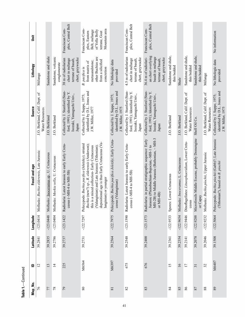
Map
_No.
IDLa
titud
eLo
ngitu
deFo
ssil
and
age
Sour
ceLi
thol
ogy
Uni
t
7612
39.2
841
-123
.041
4M
ollu
sks:
Buc
hia
elde
rens
is, L
ate
Jura
ssic
J.O. B
erkl
and,
Cal
if. D
ept.
of
Wat
er R
esou
rces
Mél
ange
7713
39.2
835
-123
.044
8M
ollu
sks:
Inoc
eram
us sp
., U
. Cre
tace
ous
J.O. B
erkl
and
Sand
ston
e an
d sh
ale
7814
39.2
786
-123
.040
4M
ollu
sks:
Mee
kia
sella
, U. C
reta
ceou
sJ.O
. Ber
klan
dSa
ndst
one,
vol
cani
c co
nglo
mer
ate
7922
539
.273
7-1
23.1
422
Rad
iola
ria: L
ates
t Jur
assi
c to
ear
ly E
arly
Cre
ta-
ceou
s (~M
H-4
to M
H-5
B)
Col
lect
ed b
y J.
Stan
ford
(Sta
n-fo
rd, 1
991)
; ide
ntifi
ed b
y Y.
Is
ozak
i, Ya
mag
uchi
Uni
v.,
Japa
n
38 m
of r
adio
laria
n ch
ert i
n m
élan
ge
terr
ane
of b
asal
t, ch
ert,
grey
wac
ke
Fran
cisc
an C
om-
plex
, Cen
tral B
elt
80M
6564
39.2
731
-122
.729
7Pe
lecy
pods
: Buc
hia
paci
fica
(Jel
etzk
y); s
triat
ed
Buch
ia (n
ew?)
sp.,
B. e
lder
ensi
s (A
nder
son)
; th
is is
a m
ixed
col
lect
ion-
Ear
ly C
reta
ceou
s (V
alan
gini
an) a
nd L
ate
Jura
ssic
(Tith
onia
n);
depo
sitio
nal a
ge is
thus
Ear
ly C
reta
ceou
s (Va
-la
ngin
ian)
or y
oung
er
Col
lect
ed b
y J.
Supp
e, 1
975;
id
entifi
ed b
y D
.L. J
ones
and
J.W
. Mill
er, 1
977
B. p
acifi
ca is
fr
om m
atrix
of
met
asan
dsto
ne;
othe
r Buc
hias
are
fr
om a
silic
ified
co
ncre
tion
Fran
cisc
an C
om-
plex
, Eas
tern
B
elt,
mél
ange
of
Yol
la B
olly
te
rran
e, G
oat
Mou
ntai
n ar
ea
81M
6397
39.2
564
-122
.797
5Pe
lecy
pods
: Buc
hia
paci
fica
Jele
tzky
; Ear
ly C
reta
-ce
ous (
Vala
ngin
ian)
Col
lect
ed b
y J.
Supp
e, 1
975;
id
entifi
ed b
y D
.L. J
ones
and
J.W
. Mill
er, 1
975
No
litho
logi
c da
ta
prov
ided
8267
539
.254
8-1
23.1
590
Rad
iola
ria: L
ates
t Jur
assi
c to
ear
ly E
arly
Cre
ta-
ceou
s (~M
H-4
to M
H-5
B)
Col
lect
ed b
y J.
Stan
ford
(Sta
n-fo
rd, 1
991)
; Ide
ntifi
ed b
y Y.
Is
ozak
i, Ya
mag
uchi
Uni
v.,
Japa
n
4.5
m o
f rad
iola
rian
cher
t in
mél
ange
te
rran
e of
bas
alt,
cher
t, gr
eyw
acke
Fran
cisc
an C
om-
plex
, Cen
tral B
elt
8367
639
.240
0-1
23.1
573
Rad
iola
ria: i
n pa
rtial
stra
tigra
phic
sequ
ence
: Ear
ly
Jura
ssic
(Plie
nsba
chia
n-B
ajoc
ian,
~MH
-1 to
M
H-2
B) t
o M
iddl
e Ju
rass
ic (B
atho
nian
, ~ M
H-3
or
MH
-4B
)
Col
lect
ed b
y J.
Stan
ford
(Sta
n-fo
rd, 1
991)
; Ide
ntifi
ed b
y Y.
Is
ozak
i, Ya
mag
uchi
Uni
v.,
Japa
n
36.4
m o
f rad
iola
ri-an
che
rt ov
erly
ing
basa
lt in
mél
ange
te
rran
e of
bas
alt,
cher
t, gr
eyw
acke
Fran
cisc
an C
om-
plex
, Cen
tral B
elt
8415
39.2
361
-122
.953
3Sp
ores
: Low
er C
reta
ceou
sJ.O
. Ber
klan
d Sa
ndst
one
and
shal
e,
thin
bed
ded
8516
39.2
354
-122
.965
4M
ollu
sks:
Inoc
eram
us, L
. Cre
tace
ous
J.O. B
erkl
and
Shal
e
8617
39.2
141
-122
.944
6D
inofl
agel
late
s: L
ituos
phae
ridi
um, L
ower
Cre
ta-
ceou
s J.O
. Ber
klan
d, C
alif.
Dep
t. of
W
ater
Res
ourc
esSa
ndst
one
and
shal
e,
thin
bed
ded
8731
39.2
078
-122
.928
8M
icro
foss
ils M
iddl
e Eo
cene
, pro
babl
y D
omen
gine
or
Cap
aySh
ell O
il C
o.Sa
ndst
one
and
shal
e,
thin
bed
ded
8832
39.2
046
-122
.923
2M
ollu
sks:
Buc
hia
pioc
hii,
Upp
er Ju
rass
icJ.O
. Ber
klan
d, C
alif.
Dep
t. of
W
ater
Res
ourc
esM
élan
ge
89M
6407
39.1
508
-122
.506
4Pe
lecy
pods
: Buc
hia
pioc
hii (
Gab
b)?;
Lat
e Ju
rass
ic
(Tith
onia
n?),
base
d on
B. p
ioch
iiC
olle
cted
by
J. Su
ppe,
197
5;
iden
tified
by
D.L
. Jon
es a
nd
J.W. M
iller
, 197
5
No
litho
logi
c da
ta
prov
ided
No
info
rmat
ion
41
Tabl
e 1.
—Co
ntin
ued

Map
_No.
IDLa
titud
eLo
ngitu
deFo
ssil
and
age
Sour
ceLi
thol
ogy
Uni
t
90O
G81
-57
39.1
427
-122
.983
2R
adio
laria
: Lat
e Ju
rass
ic (T
ithon
ian)
Col
lect
ed b
y H
.N. O
hlin
; ide
nti-
fied
By
C.D
. Blo
me
Rad
iola
rian
cher
t in
basa
ltic
volc
anic
ro
cks
Fran
cisc
an C
om-
plex
, Cen
tral B
elt
(pro
babl
y M
arin
H
eadl
ands
-Gey
-se
rs t
erra
ne)
91M
G81
-171
39.1
424
-122
.811
0R
adio
laria
: Lat
e Ju
rass
ic (T
ithon
ian)
to E
arly
C
reta
ceou
s (ea
rly V
alan
gini
an)
Col
lect
ed b
y R
.J. M
cLau
ghlin
; id
entifi
ed B
y C
.D. B
lom
eR
adio
laria
n ch
ert i
n m
élan
ge
92M
6398
39.1
417
-122
.639
4Pe
lecy
pods
: Buc
hia
cf. B
. pio
chii
(Gab
b) sp
. Juv
e-ni
le; L
ate
Jura
ssic
(Tith
onia
n)C
olle
cted
by
J. Su
ppe,
197
5;
iden
tified
by
D.L
. Jon
es a
nd
J.W. M
iller
, 197
5
No
litho
logi
c da
ta
prov
ided
93H
S-30
9(M
R10
76)
39.1
413
-122
.914
6R
adio
laria
: Lat
e Ju
rass
ic (l
ate
Kim
mer
idge
an/
early
Tith
onia
n-Em
iluvi
a H
opso
ni Z
one
2 of
Pe
ssag
no, 1
977)
Col
lect
ed b
y H
.N. O
hlin
; ide
nti-
fied
By
C.D
. Blo
me
Rad
iola
rian
cher
t in
mél
ange
Fr
anci
scan
Com
-pl
ex, C
entra
l Bel
t
94O
G81
-47
39.1
368
-122
.982
7R
adio
laria
: Lat
e Ju
rass
ic (T
ithon
ian)
Col
lect
ed b
y H
.N. O
hlin
; ide
nti-
fied
By
C.D
. Blo
me
Rad
iola
rian
cher
t in
basa
ltic
volc
anic
ro
cks
Fran
cisc
an C
om-
plex
, Cen
tral B
elt
(pro
babl
y M
arin
H
eadl
ands
-Gey
-se
rs t
erra
ne)
95M
6399
39.1
353
-122
.621
7Pe
lecy
pods
: Buc
hia
cf. B
. pio
chii
(Gab
b), I
noce
ra-
mus
sp.;
Late
Jura
ssic
(Tith
onia
n), b
ased
on
B.
pioc
hii
Col
lect
ed b
y J.
Supp
e, 1
975;
id
entifi
ed b
y D
.L. J
ones
and
J.W
. Mill
er, 1
975
No
litho
logi
c da
ta
prov
ided
96M
6400
39.1
333
-122
.612
8Pe
lecy
pods
: Buc
hia
cf. B
. eld
eren
sis (
And
erso
n);
Late
Jura
ssic
(Tith
onia
n)C
olle
cted
by
J. Su
ppe,
197
5;
iden
tified
by
D.L
. Jon
es a
nd
J.W. M
iller
, 197
5
No
litho
logi
c da
ta
prov
ided
97M
6401
39.1
325
-122
.609
7Pe
lecy
pods
: Buc
hia
pioc
hii (
Gab
b) o
r Buc
hia
elde
-re
nsis
(And
erso
n); L
ate
Jura
ssic
(Tith
onia
n)U
nkno
wn
No
litho
logi
c da
ta
prov
ided
No
info
rmat
ion
98O
G81
-29
39.1
305
-122
.955
3R
adio
laria
: Lat
e Ju
rass
ic (T
ithon
ian)
to E
arly
C
reta
ceou
s (ea
rly V
alan
gini
an)?
C
olle
cted
by
H.N
. Ohl
in; i
dent
i-fie
d B
y C
.D. B
lom
eR
adio
laria
n ch
ert i
n m
élan
geFr
anci
scan
Com
-pl
ex, C
entra
l Bel
t
99M
6404
39.1
297
-122
.631
9Pe
lecy
pods
: Buc
hia
elde
rens
is (A
nder
son)
or B
. pi
ochi
i (G
abb)
; Lat
e Ju
rass
ic (T
ithon
ian)
Col
lect
ed b
y J.
Supp
e, 1
975;
id
entifi
ed b
y D
.L. J
ones
and
J.W
. Mill
er, 1
975
No
litho
logi
c da
ta
prov
ided
No
info
rmat
ion
100
M64
0239
.126
1-1
22.5
933
Pele
cypo
ds: B
uchi
a pi
ochi
i (G
abb)
or B
uchi
a el
de-
rens
is (A
nder
son)
; Lat
e Ju
rass
ic (T
ithon
ian)
Col
lect
ed b
y J.
Supp
e, 1
975;
id
entifi
ed b
y D
.L. J
ones
and
J.W
. Mill
er, 1
975
No
litho
logi
c da
ta
prov
ided
No
info
rmat
ion
101
M64
0339
.124
4-1
22.6
219
Pele
cypo
ds: B
uchi
a sp
., in
dete
rmin
able
; Lat
e Ju
rass
ic o
r Ear
ly C
reta
ceou
sC
olle
cted
by
J. Su
ppe,
197
5;
iden
tified
by
D.L
. Jon
es a
nd
J.W. M
iller
, 197
5
No
litho
logi
c da
ta
prov
ided
No
info
rmat
ion
42
Tabl
e 1.
—Co
ntin
ued

Map
_No.
IDLa
titud
eLo
ngitu
deFo
ssil
and
age
Sour
ceLi
thol
ogy
Uni
t
102
LIS7
39.1
241
-122
.592
7M
ollu
sks:
Buc
hia
sp.,
Late
Jura
ssic
or E
arly
C
reta
ceou
sM
cLau
ghlin
and
oth
ers,
1990
; Id
entifi
ed b
y D
.L Jo
nes,
J.W.
Mill
er
Shal
e an
d sa
ndst
one
103
LIS2
339
.119
7-1
22.5
674
Mol
lusk
s: B
uchi
a pa
cific
a (J
elet
zky)
, Ear
ly C
reta
-ce
ous (
Vala
ngin
ian)
McL
augh
lin a
nd o
ther
s, 19
90;
iden
tified
by
D.L
Jone
s, J.W
. M
iller
Slat
e an
d m
etas
and-
ston
e, te
xtur
al
zone
s 1-2
, and
m
inor
met
avol
ca-
nic
rock
s
104
LIS1
439
.111
7-1
22.5
944
Mol
lusk
s: B
uchi
a sp
., La
te Ju
rass
ic o
r Ear
ly
Cre
tace
ous
McL
augh
lin a
nd o
ther
s, 19
90;
iden
tified
by
D.L
Jone
s, J.W
. M
iller
Shal
e an
d sa
ndst
one
105
LIS1
539
.111
5-1
22.5
240
Mol
lusk
:, Bu
chia
pio
chii
(Gab
b), L
ate
Jura
ssic
(T
ithon
ian)
McL
augh
lin a
nd o
ther
s, 19
90;
iden
tified
by
D.L
Jone
s, J.W
. M
iller
Slat
e an
d m
etas
and-
ston
e, te
xtur
al
zone
s 1–3
106
LIS1
639
.111
0-1
22.5
226
Mol
lusk
s: B
uchi
a el
dere
nsis
(And
erso
n), L
ate
Jura
ssic
(Tith
onia
n)M
cLau
ghlin
and
oth
ers,
1990
; id
entifi
ed b
y D
.L Jo
nes,
J.W.
Mill
er
Slat
e an
d m
etas
and-
ston
e, te
xtur
al
zone
s 1–2
107
M64
0539
.106
7-1
22.5
867
Pele
cypo
ds: B
uchi
a el
dere
nsis
(And
erso
n); L
ate
Jura
ssic
(Tith
onia
n)C
olle
cted
by
J. Su
ppe,
197
5;
iden
tified
by
D.L
. Jon
es a
nd
J.W. M
iller
, 197
5
No
litho
logi
c da
ta
prov
ided
No
info
rmat
ion
108
M64
0639
.106
7-1
22.5
867
Pele
cypo
ds: B
uchi
a el
dere
nsis
(And
erso
n); L
ate
Jura
ssic
(Tith
onia
n)C
olle
cted
by
J. Su
ppe,
197
5;
iden
tified
by
D.L
. Jon
es a
nd
J.W. M
iller
, 197
5
No
litho
logi
c da
ta
prov
ided
No
info
rmat
ion
109
LIS1
339
.105
5-1
22.5
808
Mol
lusk
s: B
uchi
a cf
. B. p
ioch
ii (G
abb)
; Lat
e Ju
ras-
sic
(Tith
onia
n)M
cLau
ghlin
and
oth
ers,
1990
; id
entifi
ed b
y D
.L Jo
nes,
J.W.
Mill
er
Shal
e an
d sa
ndst
one
110
LIS1
239
.105
4-1
22.5
791
Mol
lusk
s: B
uchi
a el
dere
nsis
(And
erso
n), L
ate
Jura
ssic
(Tith
onia
n)M
cLau
ghlin
and
oth
ers,
1990
; id
entifi
ed b
y D
.L Jo
nes,
J.W.
Mill
er
Shal
e an
d sa
ndst
one
111
LIS1
039
.104
1-1
22.5
802
Mol
lusk
s: B
uchi
a el
dere
nsis
(And
erso
n); B
. pio
chii
(Gab
b), L
ate
Jura
ssic
(Tith
onia
n)M
cLau
ghlin
and
oth
ers,
1990
; id
entifi
ed b
y D
.L Jo
nes,
J.W.
Mill
er
Shal
e, sa
ndst
one
112
LIS1
139
.103
8-1
22.5
788
Mol
lusk
s: B
uchi
a pi
ochi
i (G
abb)
, Lat
e Ju
rass
ic
(Tith
onia
n)M
cLau
ghlin
and
oth
ers,
1990
; id
entifi
ed b
y D
.L Jo
nes,
J.W.
Mill
er
Shal
e an
d sa
ndst
one
113
LIS3
139
.100
8-1
22.6
019
Mol
lusk
s: B
uchi
a el
dere
nsis
(And
erso
n); B
. pio
chii
(Gab
b), L
ate
Jura
ssic
(Tith
onia
n)M
cLau
ghlin
and
oth
ers,
1990
; id
entifi
ed b
y D
.L Jo
nes,
J.W.
Mill
er
Sand
ston
e an
d sh
ale
43
Tabl
e 1.
—Co
ntin
ued
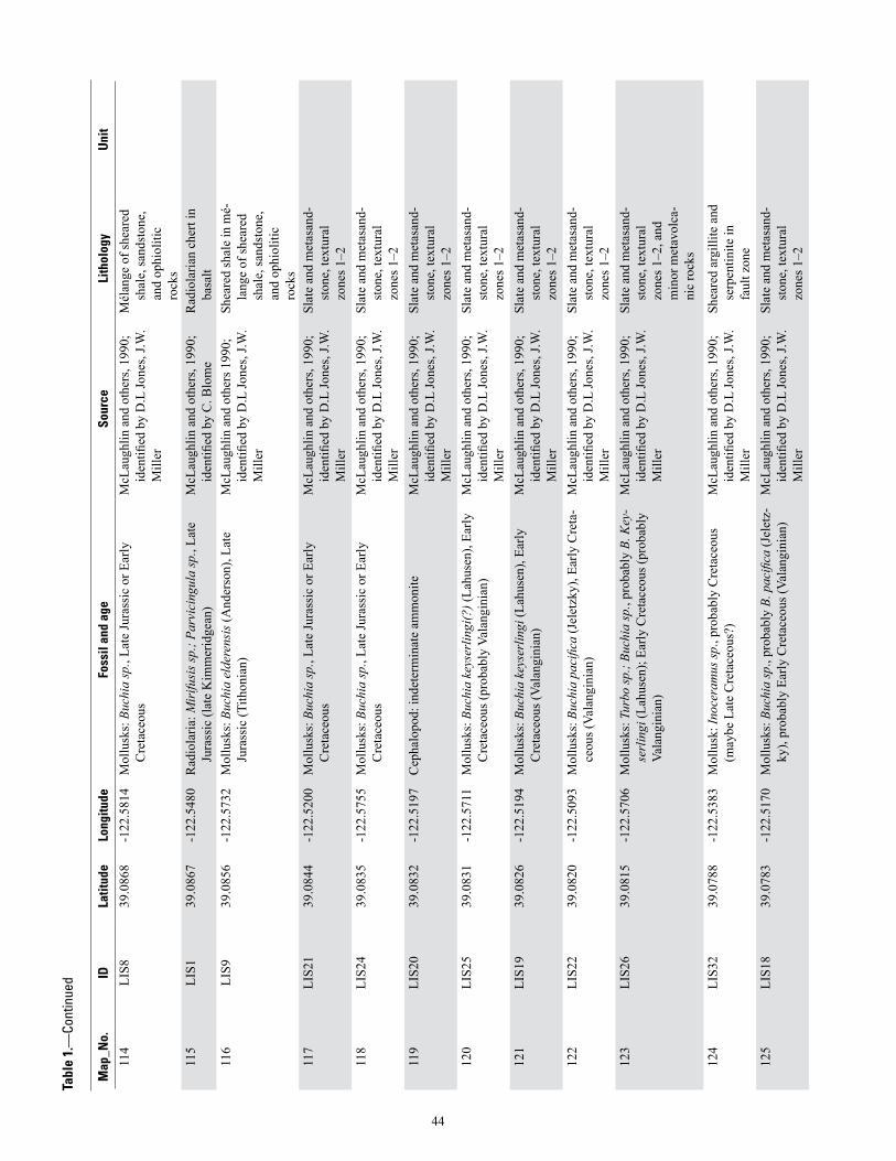
Map
_No.
IDLa
titud
eLo
ngitu
deFo
ssil
and
age
Sour
ceLi
thol
ogy
Uni
t
114
LIS8
39.0
868
-122
.581
4M
ollu
sks:
Buc
hia
sp.,
Late
Jura
ssic
or E
arly
C
reta
ceou
sM
cLau
ghlin
and
oth
ers,
1990
; id
entifi
ed b
y D
.L Jo
nes,
J.W.
Mill
er
Mél
ange
of s
hear
ed
shal
e, sa
ndst
one,
an
d op
hiol
itic
rock
s
115
LIS1
39.0
867
-122
.548
0R
adio
laria
: Mir
ifusi
s sp.
; Par
vici
ngul
a sp
., La
te
Jura
ssic
(lat
e K
imm
erid
gean
)M
cLau
ghlin
and
oth
ers,
1990
; id
entifi
ed b
y C
. Blo
me
Rad
iola
rian
cher
t in
basa
lt
116
LIS9
39.0
856
-122
.573
2M
ollu
sks:
Buc
hia
elde
rens
is (A
nder
son)
, Lat
e Ju
rass
ic (T
ithon
ian)
McL
augh
lin a
nd o
ther
s 199
0;
iden
tified
by
D.L
Jone
s, J.W
. M
iller
Shea
red
shal
e in
mé-
lang
e of
shea
red
shal
e, sa
ndst
one,
an
d op
hiol
itic
rock
s
117
LIS2
139
.084
4-1
22.5
200
Mol
lusk
s: B
uchi
a sp
., La
te Ju
rass
ic o
r Ear
ly
Cre
tace
ous
McL
augh
lin a
nd o
ther
s, 19
90;
iden
tified
by
D.L
Jone
s, J.W
. M
iller
Slat
e an
d m
etas
and-
ston
e, te
xtur
al
zone
s 1–2
118
LIS2
439
.083
5-1
22.5
755
Mol
lusk
s: B
uchi
a sp
., La
te Ju
rass
ic o
r Ear
ly
Cre
tace
ous
McL
augh
lin a
nd o
ther
s, 19
90;
iden
tified
by
D.L
Jone
s, J.W
. M
iller
Slat
e an
d m
etas
and-
ston
e, te
xtur
al
zone
s 1–2
119
LIS2
039
.083
2-1
22.5
197
Cep
halo
pod:
inde
term
inat
e am
mon
iteM
cLau
ghlin
and
oth
ers,
1990
; id
entifi
ed b
y D
.L Jo
nes,
J.W.
Mill
er
Slat
e an
d m
etas
and-
ston
e, te
xtur
al
zone
s 1–2
120
LIS2
539
.083
1-1
22.5
711
Mol
lusk
s: B
uchi
a ke
yser
lingi
(?) (
Lahu
sen)
, Ear
ly
Cre
tace
ous (
prob
ably
Val
angi
nian
)M
cLau
ghlin
and
oth
ers,
1990
; id
entifi
ed b
y D
.L Jo
nes,
J.W.
Mill
er
Slat
e an
d m
etas
and-
ston
e, te
xtur
al
zone
s 1–2
121
LIS1
939
.082
6-1
22.5
194
Mol
lusk
s: B
uchi
a ke
yser
lingi
(Lah
usen
), Ea
rly
Cre
tace
ous (
Vala
ngin
ian)
McL
augh
lin a
nd o
ther
s, 19
90;
iden
tified
by
D.L
Jone
s, J.W
. M
iller
Slat
e an
d m
etas
and-
ston
e, te
xtur
al
zone
s 1–2
122
LIS2
239
.082
0-1
22.5
093
Mol
lusk
s: B
uchi
a pa
cific
a (J
elet
zky)
, Ear
ly C
reta
-ce
ous (
Vala
ngin
ian)
McL
augh
lin a
nd o
ther
s, 19
90;
iden
tified
by
D.L
Jone
s, J.W
. M
iller
Slat
e an
d m
etas
and-
ston
e, te
xtur
al
zone
s 1–2
123
LIS2
639
.081
5-1
22.5
706
Mol
lusk
s: T
urbo
sp.;
Buch
ia sp
., pr
obab
ly B
. Key
-se
rlin
gi (L
ahus
en);
Early
Cre
tace
ous (
prob
ably
Va
lang
inia
n)
McL
augh
lin a
nd o
ther
s, 19
90;
iden
tified
by
D.L
Jone
s, J.W
. M
iller
Slat
e an
d m
etas
and-
ston
e, te
xtur
al
zone
s 1–2
, and
m
inor
met
avol
ca-
nic
rock
s
124
LIS3
239
.078
8-1
22.5
383
Mol
lusk
: Ino
cera
mus
sp.,
prob
ably
Cre
tace
ous
(may
be L
ate
Cre
tace
ous?
)M
cLau
ghlin
and
oth
ers,
1990
; id
entifi
ed b
y D
.L Jo
nes,
J.W.
Mill
er
Shea
red
argi
llite
and
se
rpen
tinite
in
faul
t zon
e
125
LIS1
839
.078
3-1
22.5
170
Mol
lusk
s: B
uchi
a sp
., pr
obab
ly B
. pac
ifica
(Jel
etz-
ky),
prob
ably
Ear
ly C
reta
ceou
s (Va
lang
inia
n)M
cLau
ghlin
and
oth
ers,
1990
; id
entifi
ed b
y D
.L Jo
nes,
J.W.
Mill
er
Slat
e an
d m
etas
and-
ston
e, te
xtur
al
zone
s 1–2
44
Tabl
e 1.
—Co
ntin
ued

Map
_No.
IDLa
titud
eLo
ngitu
deFo
ssil
and
age
Sour
ceLi
thol
ogy
Uni
t
126
LIS1
739
.077
4-1
22.5
169
Mol
lusk
s: B
uchi
a pa
cific
a (J
elet
zky)
, Ear
ly C
reta
-ce
ous (
Vala
ngin
ian)
McL
augh
lin a
nd o
ther
s, 19
90;
iden
tified
by
D.L
Jone
s, J.W
. M
iller
Slat
e an
d m
etas
and-
ston
e, te
xtur
al
zone
s 1–2
127
LIS2
839
.074
3-1
22.5
121
Mol
lusk
s: B
uchi
a sp
., po
ssib
ly B
. unc
itoid
es (P
av-
low
), La
te Ju
rass
ic o
r Ear
ly C
reta
ceou
s. If
B.
unci
toid
es, t
hen
Early
Cre
tace
ous (
Vala
ngin
ian)
McL
augh
lin a
nd o
ther
s, 19
90;
iden
tified
by
D.L
Jone
s, J.W
. M
iller
Floa
t; de
rived
fr
om sl
ate
and
met
asan
dsto
ne,
text
ural
zon
es 1
–2
128
LIS3
339
.069
7-1
22.5
273
Mol
lusk
s: B
uchi
a el
dere
nsis
(And
erso
n), L
ate
Jura
ssic
(Tith
onia
n)M
cLau
ghlin
and
oth
ers,
1990
; id
entifi
ed b
y D
.L Jo
nes,
J.W.
Mill
er
Shea
red
shal
e in
mé-
lang
e of
shea
red
shal
e, sa
ndst
one,
an
d op
hiol
itic
rock
s
129
LIS4
139
.062
2-1
22.4
420
Rad
iola
ria: P
arvi
cing
ula
altis
sim
a; P
. hsu
ii sp
.; P.
turr
ita; M
irifu
sus b
aile
yi sp
., M
.(?) m
edio
-di
litat
a; P
edob
ursa
sp.;
Saito
um p
agei
sp.,
Eucy
rtid
ium
(?) p
tyct
um; A
rcha
eodi
ctyo
mitr
a ri
gida
sp.;
Late
Jura
ssic
(Tith
onia
n, su
bzon
e 2B
of
Pes
sagn
o, 1
977)
Iden
tified
by
E.A
. Pes
-sa
gno
(Pes
sagn
o, 1
977;
loc.
N
SF99
7-A
,B,C
); ci
ted
in
McL
augh
lin a
nd o
ther
s, 19
90
Rad
iola
rian
cher
t in
basa
lt
130
LIS2
739
.058
1-1
22.4
835
Mol
lusk
s: B
uchi
a pa
cific
a (J
elet
zky)
, Ear
ly C
reta
-ce
ous (
Vala
ngin
ian)
McL
augh
lin a
nd o
ther
s, 19
90;
iden
tified
by
D.L
Jone
s, J.W
. M
iller
Shal
e an
d sa
ndst
one
131
LIS3
039
.057
0-1
22.4
937
Mol
lusk
s: B
uchi
a cr
assi
colis
(Lah
usen
) sen
su
lata
., La
te C
reta
ceou
s (Va
lang
inia
n)M
cLau
ghlin
and
oth
ers,
1990
; id
entifi
ed b
y D
.L Jo
nes,
J.W.
Mill
er
Sand
ston
e an
d sh
ale
132
kiel
-bea
r.ck
39.0
521
-122
.405
8B
ival
ves:
pro
babl
e Bu
chia
cra
ssic
ollis
solid
a,
“Mod
iola
” m
ajor
; Gas
tropo
ds: L
ithom
phal
us
ende
rlin
i, Pa
sken
tana
pas
kent
aens
is, fi
ssur
el-
lid li
mpe
t; Se
rpul
id w
orm
tube
s; so
lem
yids
; ar
coid
s; E
arly
Cre
tace
ous,
prob
ably
Val
angi
nian
Uni
v. o
f Cal
iforn
ia c
olle
ctio
ns
UC
MP
A-7
308
, UC
MP
D-2
725;
Loc
atio
n ex
amin
ed
by K
. Cam
pbel
l, 19
96, a
s re
porte
d in
Kie
l and
oth
ers,
2008
Thin
-bed
ded
silt-
ston
e tu
rbid
ites
with
in si
tu
carb
onat
e po
ds
(0.1
–1.5
m
diam
.); in
terp
ret-
ed a
s fos
sil c
old-
seep
dep
osits
Low
er G
reat
Val
ley
sequ
ence
133
MG
81-7
939
.048
6-1
22.7
364
Rad
iola
ria: L
ate
Jura
ssic
(Tith
onia
n) to
Ear
ly
Cre
tace
ous (
Vala
ngin
ian)
Col
lect
ed b
y R
.J. M
cLau
ghlin
; id
entifi
ed B
y C
.D. B
lom
eM
etac
hert,
ass
oci-
ated
with
slat
y m
etas
ands
tone
+m
etav
olca
nic
rock
s
Fran
cisc
an C
om-
plex
, Eas
tern
B
elt,
(Yol
la B
olly
te
rran
e)
45
Tabl
e 1.
—Co
ntin
ued

Map
_No.
IDLa
titud
eLo
ngitu
deFo
ssil
and
age
Sour
ceLi
thol
ogy
Uni
t
134
P439
.042
4-1
22.4
204
Bra
chio
pods
: Per
egri
nella
whi
tney
i Gab
b; M
ol-
lusk
s: M
odio
la m
ajor
; Pec
ten
com
plex
icos
ta;
Luci
na c
olus
aens
is; T
urbo
wilb
uren
sis;
Tur
bo
colu
saen
sis;
Tur
bo?
Hum
eros
us, L
ower
Cre
ta-
ceou
s, la
te B
erria
ssia
n-ea
rly H
aute
rivia
n, b
ased
on
P. w
hitn
eyi
J.E. L
awto
n, 1
956;
age
bas
ed o
n K
iel a
nd o
ther
s, 20
14D
etrit
al se
rpen
tinite
135
P139
.033
1-1
22.3
893
Bra
chio
pods
: Per
egri
nella
sp.;
Low
er C
reta
ceou
s, la
te B
erria
sian
-ear
ly H
aute
rivia
nJ.E
. Law
ton,
195
6; a
ge b
ased
on
Kie
l and
oth
ers,
2014
Det
rital
serp
entin
ite
136
LIS3
839
.033
1-1
22.4
156
Bra
chio
pods
: Per
egri
nella
whi
tney
i Gab
b; E
arly
C
reta
ceou
s, la
te B
erria
ssia
n-ea
rly H
aute
rivia
nM
cLau
ghlin
and
oth
ers,
1990
; id
entifi
ed b
y D
.L. J
ones
, J.W
. M
iller
Col
d-se
ep-r
elat
ed
limes
tone
lens
in
detri
tal s
erpe
n-tin
ite
137
LIS3
739
.032
2-1
22.4
162
Bra
chio
pods
: Per
egri
nella
whi
tney
i Gab
b; E
arly
C
reta
ceou
s, la
te B
erria
ssia
n-ea
rly H
aute
rivia
nM
cLau
ghlin
and
oth
ers,
1990
; id
entifi
ed b
y D
.L. J
ones
, J.W
. M
iller
Col
d-se
ep-r
elat
ed
limes
tone
lens
in
detri
tal s
erpe
n-tin
ite
138
P339
.031
6-1
22.4
063
Bra
chio
pods
: Per
egri
nella
sp.;
Low
er C
reta
ceou
s, la
te B
erria
sian
-ear
ly H
aute
rivia
nJ.E
. Law
ton,
195
6; a
ge b
ased
on
Kie
l and
oth
ers,
2014
Det
rital
serp
entin
ite
139
LIS3
639
.030
7-1
22.4
292
Bra
chio
pods
: Per
egri
nella
whi
tney
i Gab
b; E
arly
C
reta
ceou
s, la
te B
erria
ssia
n-ea
rly H
aute
rivia
nM
cLau
ghlin
and
oth
ers,
1990
; id
entifi
ed b
y D
.L. J
ones
, J.W
. M
iller
Det
rital
serp
entin
ite
140
P239
.030
7-1
22.3
875
Bra
chio
pods
: Per
egri
nella
sp.;
Low
er C
reta
ceou
s, la
te B
erria
sian
-ear
ly H
aute
rivia
nJ.E
. Law
ton,
195
6; a
ge b
ased
on
Kie
l and
oth
ers,
2014
Det
rital
serp
entin
ite
141
MG
81-9
639
.030
7-1
22.6
525
Rad
iola
ria: L
ate
Jura
ssic
(Tith
onia
n)C
olle
cted
by
R.J.
McL
augh
lin;
iden
tified
by
C.D
. Blo
me
Met
ache
rt, a
ssoc
i-at
ed w
ith sl
aty
met
asan
dsto
ne
+met
avol
cani
c ro
cks
142
M59
2939
.029
2-1
22.4
836
Pele
cypo
ds: B
uchi
a pi
ochi
i or B
. unc
itoid
es; L
ate
Jura
ssic
(Tith
onia
n or
Ber
riasi
an)
Col
lect
ed b
y J.C
. Max
wel
l, 19
72; i
dent
ified
by
D.L
. Jo
nes,
1972
Shal
e an
d m
inor
sa
ndst
one
Low
er G
reat
Val
ley
sequ
ence
143
M59
3139
.027
5-1
22.4
911
Pele
cypo
ds: B
uchi
a pi
ochi
i; La
te Ju
rass
ic (T
itho-
nian
)C
olle
cted
by
J.C. M
axw
ell,
1972
; ide
ntifi
ed b
y D
.L.
Jone
s, 19
72
Shal
e an
d m
inor
sa
ndst
one
Low
er G
reat
Val
ley
sequ
ence
144
kiel
-wlb
r39
.027
4-1
22.4
258
Biv
alve
s: “
Mod
iola
” m
ajor
, Sol
emya
stan
toni
, “L
ucin
a” c
olus
aens
is, P
ecte
n co
mpl
exic
osta
; G
astro
pods
: Pas
kent
ana
pask
enta
ensi
s, Re
tiske
-ne
a? tu
berc
ulat
a; B
rach
iopo
ds: P
ereg
rine
lla
whi
tney
i; Ea
rly C
reta
ceou
s (H
aute
rivia
n).
Col
lect
ed b
y K
. Cam
pbel
l.
Rep
orte
d in
Cam
pbel
l and
B
ottje
r, 19
95; C
ampb
ell a
nd
othe
rs, 2
008;
Kie
l and
oth
ers,
2008
Fibr
ous c
emen
ted
mic
ritic
car
bon-
ate,
with
in se
di-
men
tary
serp
en-
tinite
; int
erpr
eted
as
foss
il co
ld-s
eep
depo
sits
Sedi
men
tary
ser-
pent
inite
in lo
wer
G
reat
Val
ley
sequ
ence
46
Tabl
e 1.
—Co
ntin
ued

Map
_No.
IDLa
titud
eLo
ngitu
deFo
ssil
and
age
Sour
ceLi
thol
ogy
Uni
t
145
LIS2
939
.026
5-1
22.4
285
Bra
chio
pods
: Per
egri
nella
whi
tney
i Gab
b; L
ower
C
reta
ceou
s, la
te B
erria
ssia
n-ea
rly H
aute
rivia
nM
cLau
ghlin
and
oth
ers,
1990
; id
entifi
ed b
y D
.L. J
ones
, J.W
. M
iller
Shal
e, sa
ndst
one,
an
d de
trita
l ser
-pe
ntin
ite
146
LIS3
939
.026
1-1
22.3
891
Bra
chio
pods
: Per
egri
nella
whi
tney
i Gab
b; E
arly
C
reta
ceou
s, la
te B
erria
ssia
n-ea
rly H
aute
rivia
nM
cLau
ghlin
and
oth
ers,
1990
; id
entifi
ed b
y D
.L. J
ones
, J.W
. M
iller
Col
d-se
ep-r
elat
ed
limes
tone
lens
in
detri
tal s
erpe
n-tin
ite
147
M59
2839
.025
8-1
22.4
844
Pele
cypo
ds: p
roba
bly
Buc
hia
pioc
hii;
Late
Jura
ssic
(T
ithon
ian)
Col
lect
ed b
y J.C
. Max
wel
l, 19
72; i
dent
ified
by
D.L
. Jo
nes,
1972
Shal
e an
d m
inor
sa
ndst
one
Low
er G
reat
Val
ley
sequ
ence
148
M59
3239
.023
1-1
22.4
819
Pele
cypo
d: p
roba
bly
Buch
ia p
ioch
ii; L
ate
Jura
ssic
(T
ithon
ian)
C
olle
cted
by
J.C. M
axw
ell,
1972
; ide
ntifi
ed b
y D
.L.
Jone
s, 19
72
Shal
e an
d m
inor
sa
ndst
one
Low
er G
reat
Val
ley
sequ
ence
149
LIS4
39.0
231
-122
.474
4M
ollu
sks:
Buc
hia
cf. p
acifi
ca (J
elet
zky)
; Ear
ly
Cre
tace
ous (
Vala
ngin
ian)
McL
augh
lin a
nd o
ther
s, 19
90;
iden
tified
by
D.L
. Jon
es, J
.W.
Mill
er
Sand
ston
e an
d sh
ale
with
car
bona
te
lens
es
150
LIS6
39.0
228
-122
.483
4M
ollu
sks:
Buc
hia
elde
rens
is (A
nder
son)
, Lat
e Ju
rass
ic (T
ithon
ian)
McL
augh
lin a
nd o
ther
s, 19
90;
iden
tified
by
D.L
. Jon
es, J
.W.
Mill
er
Isoc
linal
ly fo
lded
sh
ale
in o
phio
litic
m
élan
ge
151
FL5
39.0
224
-122
.389
5B
rach
iopo
ds: P
ereg
rine
lla sp
.; un
iden
tified
m
acro
foss
ils; u
nide
ntifi
ed fo
ram
inife
rs; L
ower
C
reta
ceou
s
J.E. L
awto
n, 1
956
Det
rital
serp
entin
ite
152
LIS5
39.0
218
-122
.482
3M
ollu
sks:
Buc
hia
elde
rens
is (A
nder
son)
; B. p
ioch
ii (G
abb)
, Lat
e Ju
rass
ic (T
ithon
ian)
McL
augh
lin a
nd o
ther
s, 19
90;
iden
tified
by
D.L
. Jon
es, J
.W.
Mill
er
Isoc
linal
ly fo
lded
sh
ale
in o
phio
litic
m
élan
ge
153
M59
3339
.018
1-1
22.4
906
Pele
cypo
ds: B
uchi
a pi
ochi
i; La
te Ju
rass
ic (T
itho-
nian
)C
olle
cted
by
J.C. M
axw
ell,
1972
; ide
ntifi
ed b
y D
.L.
Jone
s, 19
72
Shal
e an
d m
inor
sa
ndst
one
Low
er G
reat
Val
ley
sequ
ence
154
M59
3639
.016
7-1
22.4
733
Pele
cypo
ds: B
uchi
a fis
cher
iana
; Lat
e Ju
rass
ic
(Tith
onia
n)C
olle
cted
by
J.C. M
axw
ell,
1972
; ide
ntifi
ed b
y D
.L.
Jone
s, 19
72
Shal
e an
d m
inor
sa
ndst
one
Low
er G
reat
Val
ley
sequ
ence
155
LIS3
439
.014
3-1
22.4
787
Mol
lusk
s: B
uchi
a pi
ochi
i (G
abb)
; Lat
e Ju
rass
ic
(Tith
onia
n)M
cLau
ghlin
and
oth
ers,
1990
; id
entifi
ed b
y D
.L. J
ones
, J.W
. M
iller
Shal
e an
d sa
ndst
one
156
LIS2
39.0
138
-122
.489
9M
ollu
sks:
Tur
bo sp
.; Bu
chia
pio
chii
( Gab
b); B
. el
dere
nsis
(And
erso
n), L
ate
Jura
ssic
(Tith
onia
n)M
cLau
ghlin
and
oth
ers,
1990
; id
entifi
ed b
y D
.L. J
ones
, J.W
. M
iller
Mél
ange
of s
hear
ed
shal
e, sa
ndst
one,
an
d op
hiol
itic
rock
s
47
Tabl
e 1.
—Co
ntin
ued

Map
_No.
IDLa
titud
eLo
ngitu
deFo
ssil
and
age
Sour
ceLi
thol
ogy
Uni
t
157
LIS3
539
.013
3-1
22.4
743
Mol
lusk
s: B
uchi
a pi
ochi
i (G
abb)
McL
augh
lin a
nd o
ther
s, 19
90;
iden
tified
by
D.L
. Jon
es,
Shal
e an
d sa
ndst
one
158
LIS4
039
.013
1-1
22.3
826
Bra
chio
pods
: Per
egri
nella
whi
tney
i Gab
b; E
arly
C
reta
ceou
s, la
te B
erria
ssia
n-ea
rly H
aute
rivia
nM
cLau
ghlin
and
oth
ers,
1990
; id
entifi
ed b
y D
.L. J
ones
, J.W
. M
iller
Col
d-se
ep-r
elat
ed
limes
tone
lens
in
detri
tal s
erpe
n-tin
ite
159
M59
3739
.011
1-1
22.4
903
Pele
cypo
d: B
uchi
a pi
ochi
i; La
te Ju
rass
ic (T
itho-
nian
) C
olle
cted
by
J.C. M
axw
ell,
1972
; ide
ntifi
ed b
y D
.L.
Jone
s, 19
72
Shal
e an
d m
inor
sa
ndst
one
Low
er G
reat
Val
ley
sequ
ence
160
M59
3539
.009
7-1
22.4
814
Pele
cypo
ds: B
uchi
a fis
cher
iana
; Lat
e Ju
rass
ic
(Tith
onia
n)C
olle
cted
by
J.C. M
axw
ell,
1972
; ide
ntifi
ed b
y D
.L.
Jone
s, 19
72
Shal
e an
d m
inor
sa
ndst
one
Low
er G
reat
Val
ley
sequ
ence
161
LIS3
39.0
094
-122
.491
4M
ollu
sks:
Buc
hia
elde
rens
is (A
nder
son)
; B. p
ioch
ii (G
abb)
, Lat
e Ju
rass
ic (T
ithon
ian)
McL
augh
lin a
nd o
ther
s, 19
90;
iden
tified
by
D.L
. Jon
es, J
.W.
Mill
er
Mél
ange
of s
hear
ed
shal
e, sa
ndst
one,
an
d op
hiol
itic
rock
s
162
MG
81-2
838
.999
5-1
22.7
049
Rad
iola
ria: E
arly
Cre
tace
ous (
Prob
ably
Apt
ian/
Alb
ian)
Col
lect
ed b
y R
.J. M
cLau
ghlin
; id
entifi
ed b
y C
.D. B
lom
eM
etac
hert,
ass
oci-
ated
with
slat
y m
etas
ands
tone
+m
etav
olca
nic
rock
s
Fran
cisc
an C
om-
plex
, Eas
tern
B
elt (
Yolla
Bol
ly
terr
ane)
164
P538
.997
3-1
22.3
917
Bra
chio
pods
: Per
egri
nella
sp.;
Low
er C
reta
ceou
s, la
te B
erria
sian
-ear
ly H
aute
rivia
nJ.E
. Law
ton,
195
6; a
ge b
ased
on
Kie
l and
oth
ers,
2014
Det
rital
serp
entin
ite
165
P638
.995
3-1
22.3
935
Bra
chio
pods
: Per
egri
nella
sp.;
Low
er C
reta
ceou
s, la
te B
erria
sian
-ear
ly H
aute
rivia
nJ.E
. Law
ton,
195
6; a
ge b
ased
on
Kie
l and
oth
ers,
2014
Det
rital
serp
entin
ite
166
MG
81-2
038
.994
5-1
22.6
773
Rad
iola
ria: L
ate
Jura
ssic
(Tith
onia
n) to
Ear
ly
Cre
tace
ous (
Vala
ngin
ian)
Col
lect
ed b
y R
.J. M
cLau
ghlin
; id
entifi
ed b
y C
.D. B
lom
eM
etac
hert,
ass
oci-
ated
with
slat
y m
etas
ands
tone
+m
etav
olca
nic
rock
s
Fran
cisc
an C
om-
plex
, Eas
tern
B
elt (
Yolla
Bol
ly
terr
ane)
167
MG
81-3
138
.993
7-1
22.6
983
Rad
iola
ria: L
ate
Jura
ssic
(Tith
onia
n) to
Ear
ly
Cre
tace
ous (
Vala
ngin
ian)
Col
lect
ed b
y R
.J. M
cLau
ghlin
; id
entifi
ed b
y C
.D. B
lom
eM
etac
hert,
ass
oci-
ated
with
slat
y m
etas
ands
tone
+m
etav
olca
nic
rock
s
48
Tabl
e 1.
—Co
ntin
ued
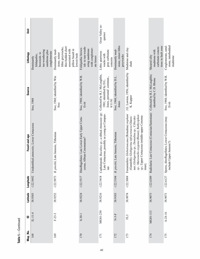
Map
_No.
IDLa
titud
eLo
ngitu
deFo
ssil
and
age
Sour
ceLi
thol
ogy
Uni
t
168
JL-1
1-4
38.9
303
-122
.569
2U
nide
ntifi
ed a
mm
onite
, Low
er C
reta
ceou
sSw
e, 1
968
Dom
inan
tly
feld
spat
hic,
br
owni
sh- t
o ta
n-w
eath
erin
g sa
ndst
one
plus
co
nglo
mer
ate
169
F-23
-338
.925
2-1
22.5
073
B. p
ioch
ii; L
ate
Jura
ssic
, Tith
onia
nSw
e, 1
968;
iden
tified
by
Win
Sw
eD
omin
antly
mud
-st
one,
min
or
lithi
c gr
eyw
acke
, th
in-b
edde
d ch
ert
asso
ciat
ed w
ith
pillo
w b
asal
t in
low
est b
eds
170
S-30
-138
.922
4-1
22.5
517
Din
oflag
ella
tes:
Lat
e Lo
wer
-Ear
ly U
pper
Cre
ta-
ceou
s, A
lbia
n-C
enom
ania
n?Sw
e, 1
968;
iden
tified
by
W.R
. Ev
itt
Feld
spat
hic
brow
n-is
h- to
tan-
wea
th-
erin
g sa
ndst
one
with
con
glom
er-
ate
lens
es
171
MG
81-2
3038
.921
6-1
22.5
418
Cep
halo
pods
: Bac
ulite
s sp.
; a ri
bbed
Am
mon
ite sp
; La
te C
reta
ceou
s, po
ssib
ly a
s you
ng a
s Cam
pan-
ian
Col
lect
ed b
y R
.J. M
cLau
ghlin
, 19
81; i
dent
ified
by
D.L
. Jo
nes,
pers
onal
com
mun
., 8/
11/8
1
Lith
ic q
uartz
ose
wac
ke w
ith
gray
car
bona
te
conc
rets
Gre
at V
alle
y se
-qu
ence
172
N-3
-F38
.918
3-1
22.5
184
B. p
ioch
ii; L
ate
Jura
ssic
, Tith
onia
nSw
e, 1
968;
iden
tified
by
D.L
. Jo
nes
Dom
inan
tly m
ud-
ston
e, m
inor
lith
ic
grey
wac
ke
173
FL3
38.9
074
-122
.308
4Fo
ram
inife
rs: G
lobo
trun
cana
(Rot
udin
a) st
epha
ni
(Gan
dolfi
); G
lobi
geri
na in
frac
reta
cea
Gla
ess-
ner;
Glo
bige
rina
sp.;
Den
talin
a sp
.; C
ibic
ides
sp
.; M
arso
nella
oxy
gona
(Reu
ss);
Bath
ysip
hon
sp.;
Upp
er C
reta
ceou
s (m
iddl
e-up
per C
enom
a-ni
an);
J.E. L
awto
n, 1
956;
iden
tified
by
K. K
uppe
rM
udst
one
and
clay
sh
ale
174
MG
81-1
1338
.907
3-1
22.6
389
Rad
iola
ria: L
ate
Cre
tace
ous (
Con
iaci
an/S
anto
nian
)C
olle
cted
by
R.J.
McL
augh
lin;
iden
tified
by
C.D
. Blo
me
Shea
red
silty
m
udst
one
with
ca
rbon
ate
conc
re-
tions
in fa
ult z
one
175
A-2
4-16
38.9
073
-122
.612
7Sp
ores
, din
oflag
ella
tes;
Low
er C
reta
ceou
s (m
ay
incl
ude
Upp
er Ju
rass
ic?)
Swe,
196
8; id
entifi
ed b
y W
.R.
Evitt
C
ongl
omer
ate,
sand
-st
one,
inte
rbed
ded
mud
ston
e
49
Tabl
e 1.
—Co
ntin
ued
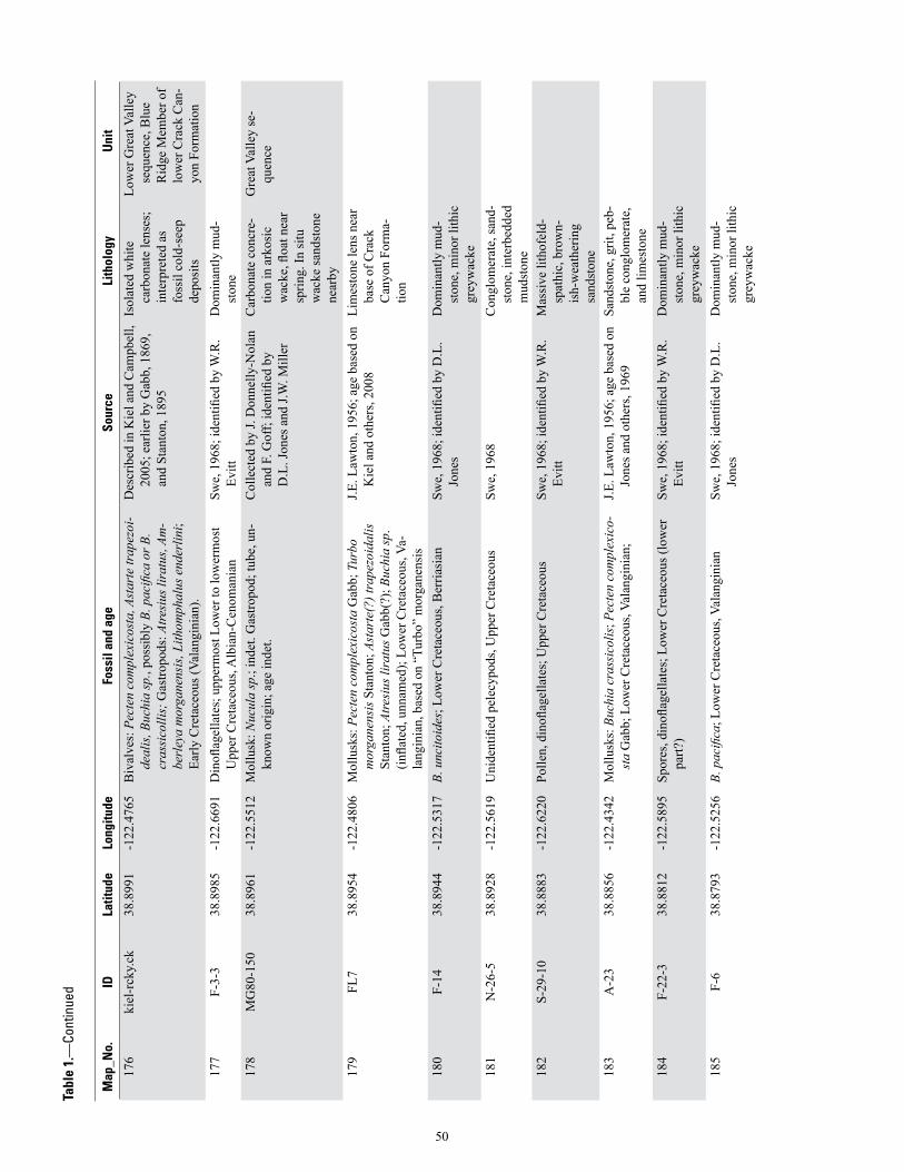
Map
_No.
IDLa
titud
eLo
ngitu
deFo
ssil
and
age
Sour
ceLi
thol
ogy
Uni
t
176
kiel
-rck
y.ck
38.8
991
-122
.476
5B
ival
ves:
Pec
ten
com
plex
icos
ta, A
star
te tr
apez
oi-
deal
is, B
uchi
a sp
., po
ssib
ly B
. pac
ifica
or B
. cr
assi
colli
s; G
astro
pods
: Atre
sius
lira
tus,
Am-
berl
eya
mor
gane
nsis
, Lith
omph
alus
end
erlin
i; Ea
rly C
reta
ceou
s (Va
lang
inia
n).
Des
crib
ed in
Kie
l and
Cam
pbel
l, 20
05; e
arlie
r by
Gab
b, 1
869,
an
d St
anto
n, 1
895
Isol
ated
whi
te
carb
onat
e le
nses
; in
terp
rete
d as
fo
ssil
cold
-see
p de
posi
ts
Low
er G
reat
Val
ley
sequ
ence
, Blu
e R
idge
Mem
ber o
f lo
wer
Cra
ck C
an-
yon
Form
atio
n17
7F-
3-3
38.8
985
-122
.669
1D
inofl
agel
late
s; u
pper
mos
t Low
er to
low
erm
ost
Upp
er C
reta
ceou
s, A
lbia
n-C
enom
ania
nSw
e, 1
968;
iden
tified
by
W.R
. Ev
itt
Dom
inan
tly m
ud-
ston
e
178
MG
80-1
5038
.896
1-1
22.5
512
Mol
lusk
: Nuc
ula
sp.;
inde
t. G
astro
pod;
tube
, un-
know
n or
igin
; age
inde
t.C
olle
cted
by
J. D
onne
lly-N
olan
an
d F.
Gof
f; id
entifi
ed b
y D
.L. J
ones
and
J.W
. Mill
er
Car
bona
te c
oncr
e-tio
n in
ark
osic
w
acke
, floa
t nea
r sp
ring.
In si
tu
wac
ke sa
ndst
one
near
by
Gre
at V
alle
y se
-qu
ence
179
FL7
38.8
954
-122
.480
6M
ollu
sks:
Pec
ten
com
plex
icos
ta G
abb;
Tur
bo
mor
gane
nsis
Sta
nton
; Ast
arte
(?) t
rape
zoid
alis
St
anto
n; A
tresi
us li
ratu
s Gab
b(?)
; Buc
hia
sp.
(infla
ted,
unn
amed
); Lo
wer
Cre
tace
ous,
Va-
lang
inia
n, b
ased
on
“Tur
bo”
mor
gane
nsis
J.E. L
awto
n, 1
956;
age
bas
ed o
n K
iel a
nd o
ther
s, 20
08Li
mes
tone
lens
nea
r ba
se o
f Cra
ck
Can
yon
Form
a-tio
n
180
F-14
38.8
944
-122
.531
7B.
unc
itoid
es; L
ower
Cre
tace
ous,
Ber
riasi
anSw
e, 1
968;
iden
tified
by
D.L
. Jo
nes
Dom
inan
tly m
ud-
ston
e, m
inor
lith
ic
grey
wac
ke
181
N-2
6-5
38.8
928
-122
.561
9U
nide
ntifi
ed p
elec
ypod
s, U
pper
Cre
tace
ous
Swe,
196
8 C
ongl
omer
ate,
sand
-st
one,
inte
rbed
ded
mud
ston
e
182
S-29
-10
38.8
883
-122
.622
0Po
llen,
din
oflag
ella
tes;
Upp
er C
reta
ceou
sSw
e, 1
968;
iden
tified
by
W.R
. Ev
itt
Mas
sive
lith
ofel
d-sp
athi
c, b
row
n-is
h-w
eath
erin
g sa
ndst
one
183
A-2
338
.885
6-1
22.4
342
Mol
lusk
s: B
uchi
a cr
assi
colis
; Pec
ten
com
plex
ico-
sta
Gab
b; L
ower
Cre
tace
ous,
Vala
ngin
ian;
J.E. L
awto
n, 1
956;
age
bas
ed o
n Jo
nes a
nd o
ther
s, 19
69Sa
ndst
one,
grit
, peb
-bl
e co
nglo
mer
ate,
an
d lim
esto
ne
184
F-22
-338
.881
2-1
22.5
895
Spor
es, d
inofl
agel
late
s; L
ower
Cre
tace
ous (
low
er
part?
)Sw
e, 1
968;
iden
tified
by
W.R
. Ev
itt
Dom
inan
tly m
ud-
ston
e, m
inor
lith
ic
grey
wac
ke
185
F-6
38.8
793
-122
.525
6B.
pac
ifica
; Low
er C
reta
ceou
s, Va
lang
inia
nSw
e, 1
968;
iden
tified
by
D.L
. Jo
nes
Dom
inan
tly m
ud-
ston
e, m
inor
lith
ic
grey
wac
ke
Tabl
e 1.
—Co
ntin
ued
50

Map
_No.
IDLa
titud
eLo
ngitu
deFo
ssil
and
age
Sour
ceLi
thol
ogy
Uni
t
186
F-5b
38.8
792
-122
.527
6B.
unc
itoid
es; L
ower
Cre
tace
ous,
Ber
riasi
anSw
e, 1
968;
iden
tified
by
Win
Sw
eD
omin
antly
mud
-st
one,
min
or li
thic
gr
eyw
acke
187
F-11
38.8
785
-122
.520
8B.
unc
itoid
es; L
ower
Cre
tace
ous,
Ber
riasi
anSw
e, 1
968;
iden
tified
by
D.L
. Jo
nes
Dom
inan
tly m
ud-
ston
e, m
inor
lith
ic
grey
wac
ke
188
D-1
1-4
38.8
781
-122
.592
8U
nide
ntifi
ed p
elec
ypod
s and
ech
inod
erm
Swe,
196
8 M
assi
ve li
thof
eld-
spat
hic,
bro
wn-
ish-
wea
ther
ing
sand
ston
e
189
F-10
(a,b
)38
.877
3-1
22.5
316
B. p
ioch
ii; L
ate
Jura
ssic
, Tith
onia
nSw
e, 1
968;
iden
tified
by
D.L
. Jo
nes
Dom
inan
tly m
ud-
ston
e, m
inor
lit
hic
grey
wac
ke,
thin
-bed
ded
cher
t as
soci
ated
with
pi
llow
bas
alt i
n lo
wes
t bed
s
190
F-10
a38
.877
3-1
22.5
316
Din
oflag
ella
tes;
Upp
er Ju
rass
ic
Swe,
196
8; id
entifi
ed b
y W
.R.
Evitt
D
omin
antly
mud
-st
one,
min
or
lithi
c gr
eyw
acke
, th
in-b
edde
d ch
ert
asso
ciat
ed w
ith
pillo
w b
asal
t in
low
est b
eds
999
M51
7139
.954
4-1
23.0
306
Cep
halo
pod:
Bel
emni
te fr
agm
ent;
Pele
cypo
ds:
scra
ps o
f lar
ge, c
oars
e-rib
bed
Buch
ia, p
ossi
bly
B. p
acifi
ca; p
roba
bly
Cre
tace
ous
Col
lect
ed b
y J.
Supp
e, 1
969;
id
entifi
ed b
y D
.L. J
ones
, 196
9N
o lit
holo
gic
data
pr
ovid
edN
o in
form
atio
n
999
M51
6939
.944
2-1
23.0
417
Pele
cypo
d: B
uchi
a pi
ochi
i; La
te Ju
rass
ic (T
itho-
nian
) C
olle
cted
by
J. Su
ppe,
196
9;
iden
tified
by
D.L
. Jon
es, 1
969
No
litho
logi
c da
ta
prov
ided
No
info
rmat
ion
999
M51
6839
.884
2-1
23.0
731
Pele
cypo
d: A
rca
teha
mae
nsis
? St
anto
n, A
mbe
r-le
ya d
iller
i Sta
nton
; Ear
ly C
reta
ceou
s (up
per
Vala
ngin
ian)
Col
lect
ed b
y J.
Supp
e, 1
969;
id
entifi
ed b
y D
.L. J
ones
, 196
9N
o lit
holo
gic
data
pr
ovid
edN
o in
form
atio
n
999
M51
7339
.808
1-1
22.9
878
Pele
cypo
d: p
roba
bly
Buch
ia c
f. B.
pio
chii;
pro
b-ab
ly L
ate
Jura
ssic
(Tith
onia
n), b
ut p
rese
rvat
ion
poor
Col
lect
ed b
y J.
Supp
e, 1
969;
id
entifi
ed b
y D
.L. J
ones
, 196
9N
o lit
holo
gic
data
pr
ovid
edN
o in
form
atio
n
999
M51
7239
.802
2-1
23.0
389
Pele
cypo
d: B
uchi
a cf
. B. p
acifi
ca; E
arly
Cre
ta-
ceou
s (Va
lang
inia
n?)
Col
lect
ed b
y J.
Supp
e, 1
969;
id
entifi
ed b
y D
.L. J
ones
, 196
9N
o lit
holo
gic
data
pr
ovid
edN
o in
form
atio
n
999
M51
7039
.800
6-1
23.0
344
Pele
cypo
d: B
uchi
a pi
ochi
i?; L
ate
Jura
ssic
(Tith
o-ni
an)?
C
olle
cted
by
J. Su
ppe,
196
9;
iden
tified
by
D.L
. Jon
es, 1
969
No
litho
logi
c da
ta
prov
ided
No
info
rmat
ion
Tabl
e 1.
—Co
ntin
ued
51

Map
_No.
IDLa
titud
eLo
ngitu
deFo
ssil
and
age
Sour
ceLi
thol
ogy
Uni
t
999
M65
6339
.773
6-1
22.7
278
Pele
cypo
ds: B
uchi
a pa
cific
a (J
elet
zky)
; Ear
ly
Cre
tace
ous (
early
mid
dle
Vala
ngin
ian)
Col
lect
ed b
y J.
Supp
e, 1
977;
id
entifi
ed b
y D
.L. J
ones
, 197
7 M
eta
argi
llite
and
m
etas
ands
tone
Fran
cisc
an C
om-
plex
, Eas
tern
B
elt,
mél
ange
of
Yol
la B
olly
te
rran
e, G
oat
Mou
ntai
n ar
ea99
9M
6598
39.7
628
-123
.068
6Pe
lecy
pods
: pos
sibl
y Bu
chia
sp.,
cf. B
. key
serl
ingi
(L
ahus
en);
poss
ibly
Ear
ly C
reta
ceou
s (la
test
Va
lang
inia
n)?
Col
lect
ed b
y J.C
. Max
wel
l, U
niv.
of T
exas
, Aus
tin, 1
976;
id
entifi
ed b
y D
.L. J
ones
, 197
7
Shea
red
argi
llite
Fr
anci
scan
Com
-pl
ex, C
entra
l Bel
t, “P
oiso
n R
ock”
m
élan
ge
999
M65
9939
.762
5-1
23.0
683
Pele
cypo
d: to
o po
orly
pre
serv
ed fo
r defi
nitiv
e id
ent,
but m
ay b
e B.
key
serl
ingi
C
olle
cted
by
J.C. M
axw
ell,
Uni
v. o
f Tex
as, A
ustin
, 197
6;
iden
tified
by
D.L
. Jon
es, 1
977
Shea
red
argi
llite
Fr
anci
scan
Com
-pl
ex, C
entra
l Bel
t, “P
oiso
n R
ock”
m
élan
ge
999
O-8
-238
.871
9-1
22.5
279
Din
oflag
ella
tes;
Upp
er Ju
rass
ic
Swe,
196
8; id
entifi
ed b
y W
.R.
Evitt
O
phio
litic
mél
ange
999
A-3
-838
.871
0-1
22.6
141
Turr
itella
pac
heco
ensi
s, Pa
leoc
ene
Swe,
196
8; id
entifi
ed b
y W
in
Swe
Mas
sive
, stru
ctur
e-le
ss sa
ndst
one,
m
udst
one,
and
co
nglo
mer
ate
999
O-2
5-5a
38.8
680
-122
.561
9B.
pac
ifica
; Low
er C
reta
ceou
s, Va
lang
inia
nSw
e, 1
968;
iden
tified
by
Win
Sw
eC
ongl
omer
ate,
sand
-st
one,
inte
rbed
ded
mud
ston
e
999
D-1
0-3
38.8
634
-122
.543
1Bu
chia
pio
chii,
rew
orke
d in
Low
er C
reta
ceou
sSw
e, 1
968;
iden
tified
by
D.L
. Jo
nes
Sand
ston
e, in
terb
ed-
ded
mud
ston
e
999
D-1
0-3(
1)38
.863
4-1
22.5
431
Din
oflag
ella
tes;
Low
er C
reta
ceou
s Sw
e, 1
968;
iden
tified
by
W.R
. Ev
itt
Con
glom
erat
e, sa
nd-
ston
e, in
terb
edde
d m
udst
one
999
D-1
0-3(
2)38
.863
4-1
22.5
431
Din
oflag
ella
tes;
Upp
er Ju
rass
ic re
wor
ked
into
Lo
wer
Cre
tace
ous
Swe,
196
8; id
entifi
ed b
y W
.R.
Evitt
Con
glom
erat
e, sa
nd-
ston
e, in
terb
edde
d m
udst
one
999
MG
81-1
6238
.861
6-1
22.6
694
Rad
iola
ria: L
ate
Jura
ssic
(Tith
onia
n)C
olle
cted
by
R.J.
McL
augh
lin;
iden
tified
by
C.D
. Blo
me
Rad
iola
rian
cher
t in
oph
iolit
ic
mél
ange
999
F-4-
338
.861
1-1
22.7
421
Polle
n, d
inofl
agel
late
s; U
pper
Cre
tace
ous
Swe,
196
8; id
entifi
ed b
y W
.R.
Evitt
Si
ltsto
ne a
nd in
ter-
bedd
ed m
assi
ve
fine-
grai
ned
whi
te
sand
ston
e
Tabl
e 1.
—Co
ntin
ued
52
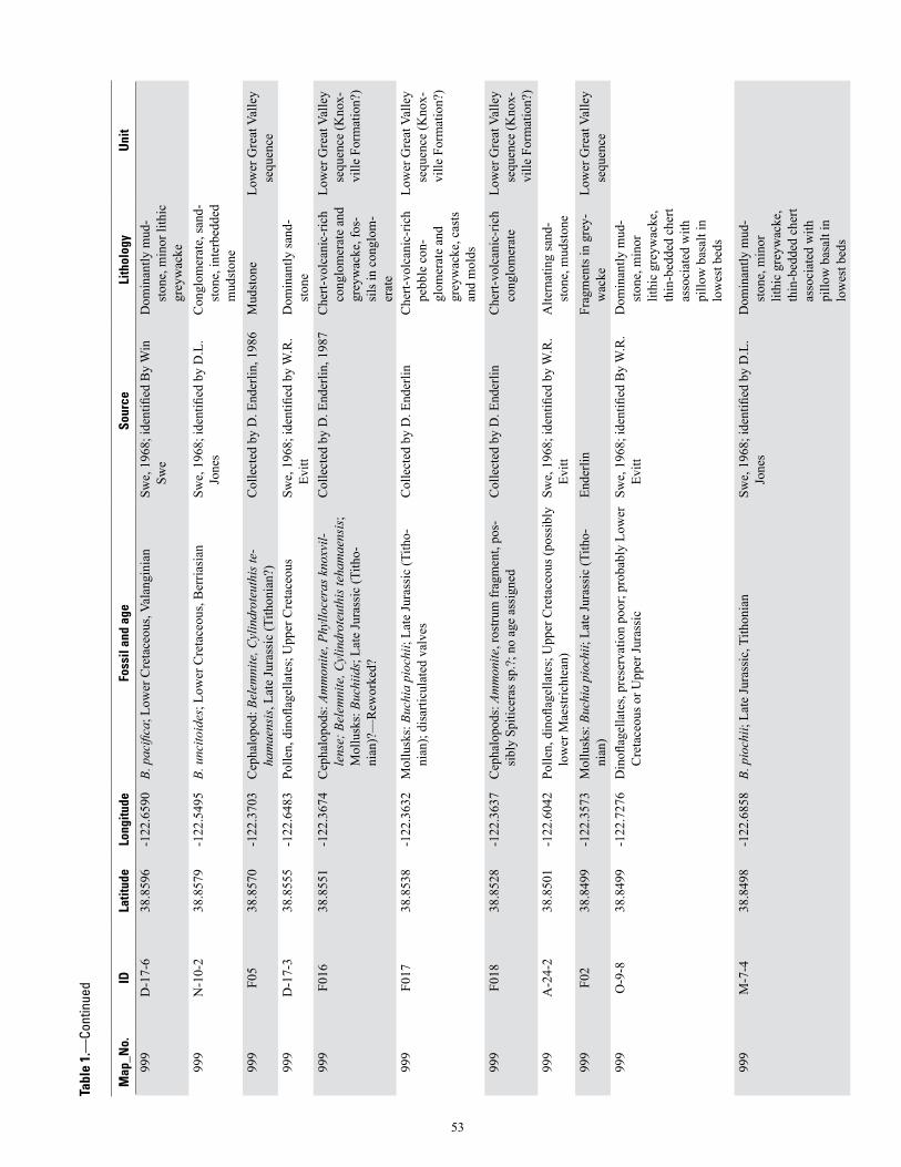
Map
_No.
IDLa
titud
eLo
ngitu
deFo
ssil
and
age
Sour
ceLi
thol
ogy
Uni
t
999
D-1
7-6
38.8
596
-122
.659
0B.
pac
ifica
; Low
er C
reta
ceou
s, Va
lang
inia
nSw
e, 1
968;
iden
tified
By
Win
Sw
eD
omin
antly
mud
-st
one,
min
or li
thic
gr
eyw
acke
999
N-1
0-2
38.8
579
-122
.549
5B.
unc
itoid
es; L
ower
Cre
tace
ous,
Ber
riasi
anSw
e, 1
968;
iden
tified
by
D.L
. Jo
nes
Con
glom
erat
e, sa
nd-
ston
e, in
terb
edde
d m
udst
one
999
F05
38.8
570
-122
.370
3C
epha
lopo
d: B
elem
nite
, Cyl
indr
oteu
this
te-
ham
aens
is, L
ate
Jura
ssic
(Tith
onia
n?)
Col
lect
ed b
y D
. End
erlin
, 198
6M
udst
one
Low
er G
reat
Val
ley
sequ
ence
999
D-1
7-3
38.8
555
-122
.648
3Po
llen,
din
oflag
ella
tes;
Upp
er C
reta
ceou
sSw
e, 1
968;
iden
tified
by
W.R
. Ev
itt
Dom
inan
tly sa
nd-
ston
e
999
F016
38.8
551
-122
.367
4C
epha
lopo
ds: A
mm
onite
, Phy
lloce
ras k
noxv
il-le
nse;
Bel
emni
te, C
ylin
drot
euth
is te
ham
aens
is;
Mol
lusk
s: B
uchi
ids;
Lat
e Ju
rass
ic (T
itho-
nian
)?—
Rew
orke
d?
Col
lect
ed b
y D
. End
erlin
, 198
7C
hert-
volc
anic
-ric
h co
nglo
mer
ate
and
grey
wac
ke, f
os-
sils
in c
ongl
om-
erat
e
Low
er G
reat
Val
ley
sequ
ence
(Kno
x-vi
lle F
orm
atio
n?)
999
F017
38.8
538
-122
.363
2M
ollu
sks:
Buc
hia
pioc
hii;
Late
Jura
ssic
(Tith
o-ni
an);
disa
rticu
late
d va
lves
Col
lect
ed b
y D
. End
erlin
Che
rt-vo
lcan
ic-r
ich
pebb
le c
on-
glom
erat
e an
d gr
eyw
acke
, cas
ts
and
mol
ds
Low
er G
reat
Val
ley
sequ
ence
(Kno
x-vi
lle F
orm
atio
n?)
999
F018
38.8
528
-122
.363
7C
epha
lopo
ds: A
mm
onite
, ros
trum
frag
men
t, po
s-si
bly
Spiti
cera
s sp.
?; n
o ag
e as
sign
edC
olle
cted
by
D. E
nder
linC
hert-
volc
anic
-ric
h co
nglo
mer
ate
Low
er G
reat
Val
ley
sequ
ence
(Kno
x-vi
lle F
orm
atio
n?)
999
A-2
4-2
38.8
501
-122
.604
2Po
llen,
din
oflag
ella
tes;
Upp
er C
reta
ceou
s (po
ssib
ly
low
er M
aest
richt
ean)
Swe,
196
8; id
entifi
ed b
y W
.R.
Evitt
A
ltern
atin
g sa
nd-
ston
e, m
udst
one
999
F02
38.8
499
-122
.357
3M
ollu
sks:
Buc
hia
pioc
hii;
Late
Jura
ssic
(Tith
o-ni
an)
Ende
rlin
Frag
men
ts in
gre
y-w
acke
Low
er G
reat
Val
ley
sequ
ence
999
O-9
-838
.849
9-1
22.7
276
Din
oflag
ella
tes,
pres
erva
tion
poor
; pro
babl
y Lo
wer
C
reta
ceou
s or U
pper
Jura
ssic
Sw
e, 1
968;
iden
tified
By
W.R
. Ev
itt
Dom
inan
tly m
ud-
ston
e, m
inor
lit
hic
grey
wac
ke,
thin
-bed
ded
cher
t as
soci
ated
with
pi
llow
bas
alt i
n lo
wes
t bed
s
999
M-7
-438
.849
8-1
22.6
858
B. p
ioch
ii; L
ate
Jura
ssic
, Tith
onia
nSw
e, 1
968;
iden
tified
by
D.L
. Jo
nes
Dom
inan
tly m
ud-
ston
e, m
inor
lit
hic
grey
wac
ke,
thin
-bed
ded
cher
t as
soci
ated
with
pi
llow
bas
alt i
n lo
wes
t bed
s
Tabl
e 1.
—Co
ntin
ued
53

Map
_No.
IDLa
titud
eLo
ngitu
deFo
ssil
and
age
Sour
ceLi
thol
ogy
Uni
t
999
M-7
-438
.849
8-1
22.6
858
Din
oflag
ella
tes;
Upp
er Ju
rass
ic
Swe,
196
8; id
entifi
ed B
y W
.R.
Evitt
D
omin
antly
mud
-st
one,
min
or
lithi
c gr
eyw
acke
, th
in-b
edde
d ch
ert
asso
ciat
ed w
ith
pillo
w b
asal
t in
low
est b
eds
999
N-1
0-3
38.8
489
-122
.524
7B.
fisc
heri
ana?
; Lat
e Ju
rass
ic, T
ithon
ian
Swe,
196
8; id
entifi
ed b
y D
.L.
Jone
sD
omin
antly
mud
-st
one,
min
or
lithi
c gr
eyw
acke
, th
in-b
edde
d ch
ert
asso
iate
d w
ith
pillo
w b
asal
t in
low
est b
eds
999
F01
38.8
489
-122
.356
5M
ollu
sks:
Buc
hia
pioc
hii;
Late
Jura
ssic
(Tith
o-ni
an)
Ende
rlin
Frag
men
ts in
gre
y-w
acke
Low
er G
reat
Val
ley
sequ
ence
999
F025
38.8
476
-122
.344
6Bu
chiid
s (in
flate
d fo
rms,
disa
rticu
late
d va
lves
) co
bble
in c
reek
; no
outc
rop;
Ear
ly C
reta
ceou
s?C
olle
cted
by
D. E
nder
linC
alca
reou
s san
d-st
one
Low
er G
reat
Val
ley
sequ
ence
(Cra
ck
Can
yon
Form
a-tio
n)99
9N
-10-
438
.847
6-1
22.5
216
B. p
ioch
ii; L
ate
Jura
ssic
, Tith
onia
nSw
e, 1
968;
iden
tified
by
D.L
. Jo
nes
Dom
inan
tly m
ud-
ston
e, m
inor
lith
ic
grey
wac
ke
999
F06
38.8
472
-122
.348
7M
ollu
sks:
Buc
hia
paci
fica?
; Ear
ly C
reta
ceou
s (V
alan
gini
an?)
Ende
rlin
“Mar
ly c
obbl
e” in
cr
eek;
no
outc
rop
Low
er G
reat
Val
ley
sequ
ence
(Cra
ck
Can
yon
Form
a-tio
n)99
9F0
738
.847
2-1
22.3
467
Mol
lusk
s: B
uchi
a pa
cific
a?; E
arly
Cre
tace
ous
(Val
angi
nian
?)En
derli
nC
alca
reou
s fine
-gr
aine
d sa
ndst
one
and
silts
tone
Low
er G
reat
Val
ley
sequ
ence
(Cra
ck
Can
yon
Form
a-tio
n)99
9F0
1938
.846
0-1
22.3
607
Mol
lusk
s: d
isar
ticul
ated
smal
l val
ves,
Buch
ia
pioc
hii;
Cep
halo
pods
: Am
mon
ite ro
stru
m fr
ag-
men
t, Ph
yllo
cera
s kno
xvill
ense
; Lat
e Ju
rass
ic
(Tith
onia
n)
Col
lect
ed b
y D
. End
erlin
Hyd
roth
erm
ally
bl
each
ed, l
ocal
ly
pyrit
ized
arg
illic
al
tera
tion
Low
er G
reat
Val
ley
sequ
ence
999
F026
38.8
454
-122
.353
8M
ollu
sks:
Buc
hia
pioc
hii,
valv
es a
nd fr
agm
ents
; La
te Ju
rass
ic?
(Tith
onia
n)?
Col
lect
ed b
y D
. End
erlin
Mas
sive
sand
ston
eLo
wer
Gre
at V
alle
y se
quen
ce (K
nox-
ville
For
mat
ion?
)99
9F-
18-1
638
.844
7-1
22.5
894
Des
mop
hylli
tes d
iphy
lloid
es; U
pper
Cre
tace
ous,
Cam
pani
an a
nd p
ossi
bly
Late
Maa
stric
htia
nSw
e, 1
968;
iden
tified
By
Win
Sw
eA
ltern
atin
g sa
nd-
ston
e, m
udst
one
Tabl
e 1.
—Co
ntin
ued
54

Map
_No.
IDLa
titud
eLo
ngitu
deFo
ssil
and
age
Sour
ceLi
thol
ogy
Uni
t
999
D-1
9-3
38.8
413
-122
.646
6D
inofl
agel
late
s; p
roba
bly
Upp
er Ju
rass
icSw
e, 1
968;
iden
tified
by
W.R
. Ev
itt
Dom
inan
tly m
ud-
ston
e, m
inor
lit
hic
grey
wac
ke,
thin
-bed
ded
cher
t as
soci
ated
with
pi
llow
bas
alt i
n lo
wes
t bed
s
999
F04
38.8
411
-122
.349
1M
ollu
sks:
Buc
hiid
val
ve; L
ate
Jura
ssic
or E
arly
C
reta
ceou
s E
nder
linSi
ltsto
ne-d
omin
ated
tu
rbid
ites,
over
-tu
rned
, dis
rupt
ed
Low
er G
reat
Val
ley
sequ
ence
999
F011
38.8
404
-122
.336
3M
ollu
sks:
Buc
hiid
s, sm
all v
alve
s (to
1 c
m),
infla
ted
form
(juv
enile
?) ;
rew
orke
d? N
o ag
e as
sign
ed
Col
lect
ed b
y D
. End
erlin
Mar
l and
gre
ywac
keLo
wer
Gre
at V
alle
y se
quen
ce (C
rack
C
anyo
n Fo
rma-
tion?
)
999
F021
38.8
381
-122
.343
5M
ollu
sks:
Buc
hiid
s (B.
pio
chii?
), La
te Ju
rass
ic?
(Tith
onia
n?)
Obs
erve
d by
End
erlin
; lef
t in
plac
eC
obbl
e of
mar
lLo
wer
Gre
at V
alle
y se
quen
ce (K
nox-
ville
For
mat
ion?
)99
9F0
1038
.837
6-1
22.3
342
Mol
lusk
s: B
uchi
a pa
cific
a?; E
arly
Cre
tace
ous
(Val
angi
nian
?)C
olle
cted
by
D. E
nder
linC
ongl
omer
ate,
bou
l-de
r on
ridge
top
trail
Low
er G
reat
Val
ley
sequ
ence
(Cra
ck
Can
yon
Form
a-tio
n)99
9F0
1538
.836
7-1
22.3
381
Mol
lusk
s: v
alve
frag
men
ts, B
uchi
a pa
cific
a?;
Early
Cre
tace
ous (
Vala
ngin
ian?
)C
olle
cted
by
D. E
nder
linO
rang
e, m
arly
gre
y-w
acke
Low
er G
reat
Val
ley
sequ
ence
(Cra
ck
Can
yon
Form
a-tio
n)99
9F0
1438
.835
5-1
22.3
274
Mol
lusk
s: M
odio
la sp
; Tur
bo sp
.(pos
sibl
y T.
pa
sken
tana
?); E
arly
Cre
tace
ous (
prob
ably
H
aute
rivia
n or
you
nger
?)
Col
lect
ed b
y D
. End
erlin
, R.J.
M
cLau
ghlin
, and
W. E
lder
, 20
07
Bou
lder
s and
ou
tcro
p in
Fol
ey
Cre
ek; a
ssoc
i-at
ed w
ith d
etrit
al
serp
entin
ite a
nd
cold
-see
p se
tting
Low
er G
reat
Val
ley
sequ
ence
(tra
n-si
tiona
l, C
rack
C
anyo
n an
d Li
ttle
Valle
y Fo
rma-
tions
)
999
F03
38.8
355
-122
.347
1M
ollu
sks:
Buc
hiid
frag
men
ts; L
ate
Jura
ssic
or
Early
Cre
tace
ous
Ende
rlin
Frag
men
ts in
5-f
t-th
ick
grey
wac
ke
bed
Low
er G
reat
Val
ley
sequ
ence
999
F09
38.8
345
-122
.340
3M
ollu
sks:
Buc
hia
pioc
hii?
; Cep
halo
pod:
pos
sibl
y C
ylin
drot
euth
is te
ham
aens
is?;
Lat
e Ju
rass
ic
(Tith
onia
n?)
Col
lect
ed b
y D
. End
erlin
Mar
ly m
udst
one
Low
er G
reat
Val
ley
sequ
ence
Tabl
e 1.
—Co
ntin
ued
55

Map
_No.
IDLa
titud
eLo
ngitu
deFo
ssil
and
age
Sour
ceLi
thol
ogy
Uni
t
999
F08
38.8
341
-122
.337
1M
ollu
sks:
Buc
hia
paci
fica?
; Ear
ly C
reta
ceou
s (V
alan
gini
an?)
Ende
rlin
Gre
ywac
ke fl
oat;
not a
bund
ant
Low
er G
reat
Val
ley
sequ
ence
(Cra
ck
Can
yon
Form
a-tio
n)99
9F0
2038
.832
4-1
22.3
423
Mol
lusk
s: B
uchi
a pi
ochi
i, di
sarti
cula
ted
valv
es;
Late
Jura
ssic
(Tith
onia
n)C
olle
cted
by
D. E
nder
linC
hert-
volc
anic
-ric
h pe
bble
con
glom
-er
ate;
bel
ow
basa
l con
tact
with
ba
salti
c an
desi
te
intru
sive
of C
lear
La
ke V
olca
nics
Low
er G
reat
Val
ley
sequ
ence
(Kno
x-vi
lle F
orm
atio
n?)
999
F012
38.8
321
-122
.323
3B
rach
iopo
ds: P
ereg
rine
lla w
hitn
eyi i
n bi
ocla
s-tic
deb
ris; E
arly
Cre
tace
ous (
prob
ably
late
B
erria
sian
-ear
ly H
aute
rivia
n)
Col
lect
ed b
y D
. End
erlin
Det
rital
serp
entin
ite,
mic
ritic
mud
-st
one,
and
bro
wn
sand
ston
e; c
old-
seep
dep
osit
Low
er G
reat
Val
ley
sequ
ence
(tra
n-si
tiona
l, C
rack
C
anyo
n an
d Li
ttle
Valle
y Fo
rma-
tions
)99
9ki
el-f
oley
.cyn
38.8
316
-122
.323
1B
ival
ves:
“M
odio
la”
maj
or, “
infla
ted”
Buc
hia
sp.;
Gas
tropo
ds: P
aske
ntan
a pa
sken
taen
sis,
Bra
chio
-po
ds: P
ereg
rine
lla w
hitn
eyi;
Early
Cre
tace
ous
(Val
angi
nian
-Hau
teriv
ian)
Des
crib
ed b
y D
. End
erlin
in
Kie
l and
oth
ers,
2008
Two
faul
t-bou
nded
pa
ralle
l len
ses o
f ca
rbon
ate
near
or
in se
dim
enta
ry
serp
entin
ite b
ody
with
in C
rack
C
anyo
n Fo
rma-
tion
sedi
men
tary
se
ctio
n; fo
rmer
ly
quar
ried
for l
ime;
in
terp
rete
d as
fo
ssil
cold
-see
p de
posi
ts
Low
er G
reat
Val
ley
sequ
ence
, Cra
ck
Can
yon
Form
a-tio
n
999
F013
38.8
316
-122
.322
8M
ollu
sks:
Tur
bo sp
., M
odio
la sp
., Pe
cten
sp.;
Early
Cre
tace
ous (
prob
ably
late
Ber
riasi
an-e
arly
H
aute
rivia
n) b
ased
on
F012
loc.
Col
lect
ed b
y D
. End
erlin
Lim
esto
ne m
arl a
nd
mic
ritic
mud
ston
e as
soci
ated
with
de
trita
l ser
pen-
tinite
Low
er G
reat
Val
ley
sequ
ence
(tra
n-si
tiona
l, C
rack
C
anyo
n an
d Li
ttle
Valle
y Fo
rma-
tions
)99
9Ja
-16-
538
.831
1-1
22.6
368
Polle
n, d
inofl
agel
late
s; U
pper
Cre
tace
ous
Swe,
196
8; id
entifi
ed b
y W
.R.
Evitt
D
omin
antly
sand
-st
one
999
D-1
6-5
38.8
311
-122
.636
8B.
pac
ifica
; Low
er C
reta
ceou
s, Va
lang
inia
nSw
e, 1
968;
iden
tified
by
D.L
. Jo
nes
Dom
inan
tly m
ud-
ston
e, m
inor
lith
ic
grey
wac
ke
Tabl
e 1.
—Co
ntin
ued
56

Map
_No.
IDLa
titud
eLo
ngitu
deFo
ssil
and
age
Sour
ceLi
thol
ogy
Uni
t
999
F024
38.8
308
-122
.336
9M
ollu
sks:
Buc
hia
pioc
hii,
wel
l pre
serv
ed e
xter
ior
cast
s; L
ate
Jura
ssic
(Tith
onia
n);
Col
lect
ed b
y D
. End
erlin
Gre
ywac
ke; a
ssoc
i-at
ed w
ith b
lack
fo
ssili
zed
plan
t re
mai
ns
Low
er G
reat
Val
ley
sequ
ence
(Kno
x-vi
lle F
orm
atio
n?)
999
F023
38.8
265
-122
.336
9M
ollu
sks:
Buc
hia
pioc
hii,
only
one
val
ve; L
ate
Jura
ssic
(Tith
onia
n);
Col
lect
ed b
y D
. End
erlin
Gra
y m
udst
one
Low
er G
reat
Val
ley
sequ
ence
(Kno
x-vi
lle F
orm
atio
n?)
999
F022
38.8
240
-122
.333
5M
ollu
sks:
Buc
hia
pioc
hii,
abun
dant
mol
ds; L
ate
Jura
ssic
(Tith
onia
n);
Obs
erve
d by
D. E
nder
linG
ray
mud
ston
e an
d si
ltsto
neLo
wer
Gre
at V
alle
y se
quen
ce (K
nox-
ville
For
mat
ion?
)99
9F-
438
.819
4-1
22.5
745
Inoc
eram
us sc
hmid
ti; U
pper
Cre
tace
ous,
Mid
dle-
Upp
er C
ampa
nian
Swe,
196
8; id
entifi
ed b
y D
.L.
Jone
sA
ltern
atin
g sa
nd-
ston
e, m
udst
one
999
WS-
F-4
38.8
194
-122
.574
5Po
llen,
din
oflag
ella
tes;
Upp
er C
reta
ceou
sSw
e, 1
968;
iden
tified
by
W.R
. Ev
itt
Alte
rnat
ing
sand
-st
one,
mud
ston
e
999
M-6
-138
.809
9-1
22.6
156
Nos
troce
ras ?
sp.;
Upp
er C
reta
ceou
s, C
ampa
nian
Swe,
196
8; id
entifi
ed b
y D
.L.
Jone
sD
omin
antly
sand
-st
one
999
Ja-1
4-8
38.8
090
-122
.637
1Fo
ram
inife
rs; B
athy
siph
on p
eram
pla(
?); U
pper
C
reta
ceou
sSw
e, 1
968;
iden
tified
by
Win
Sw
eSi
ltsto
ne a
nd in
ter-
bedd
ed m
assi
ve
fine-
grai
ned
whi
te
sand
ston
e
999
F-17
-138
.800
0-1
22.6
636
Spor
es, d
inofl
agel
late
s; p
roba
bly
Low
er C
reta
-ce
ous
Swe,
196
8; id
entifi
ed b
y W
.R.
Evitt
M
udst
one
with
th
in in
terb
ed-
ded
quar
tz-r
ich
sand
ston
e
999
Ja-1
3-8
38.7
968
-122
.677
4D
inofl
agel
late
s; U
pper
Jura
ssic
or L
ower
Cre
ta-
ceou
sSw
e, 1
968;
iden
tified
by
W.R
. Ev
itt
Dom
inan
tly m
ud-
ston
e, m
inor
lit
hic
grey
wac
ke,
thin
-bed
ded
cher
t as
soci
ated
with
pi
llow
bas
alt i
n lo
wes
t bed
s
999
F-7-
638
.791
8-1
22.6
245
Polle
n, d
inofl
agel
late
s; U
pper
Cre
tace
ous
Swe,
196
8; id
entifi
ed b
y W
.R.
Evitt
D
omin
antly
sand
-st
one
999
Ja-1
0-F
38.7
870
-122
.627
3U
nide
ntifi
ed p
elec
ypod
s, U
pper
Cre
tace
ous
Swe,
196
8 Si
ltsto
ne a
nd in
ter-
bedd
ed m
assi
ve
fine-
grai
ned
whi
te
sand
ston
e
Tabl
e 1.
—Co
ntin
ued
57

Map
_No.
IDLa
titud
eLo
ngitu
deFo
ssil
and
age
Sour
ceLi
thol
ogy
Uni
t
999
F-17
-13
38.7
854
-122
.650
5D
inofl
agel
late
s; L
ower
Cre
tace
ous (
Upp
er
Ber
riasi
an-V
alan
gini
anSw
e, 1
968;
iden
tified
by
W.R
. Ev
itt
Mud
ston
e w
ith
thin
inte
rbed
-de
d qu
artz
-ric
h sa
ndst
one
999
Ja-9
-12
38.7
832
-122
.608
2Sp
ores
, din
oflag
ella
tes;
Low
er C
reta
ceou
s (qu
es-
tiona
ble A
ptia
n?)
Swe,
196
8; id
entifi
ed b
y W
.R.
Evitt
M
udst
one
with
th
in in
terb
ed-
ded
quar
tz-r
ich
sand
ston
e
999
F-8-
238
.781
7-1
22.6
243
Cuc
ulla
ea sp
. and
stra
ight
con
ical
thin
-she
lled
ceph
alop
ods
Swe,
196
8; id
entifi
ed B
y A
. M
yra
Kee
nSi
ltsto
ne a
nd in
ter-
bedd
ed m
assi
ve
fine-
grai
ned
whi
te
sand
ston
e
999
F-8-
238
.781
7-1
22.6
243
Polle
n; U
pper
Cre
tace
ous
Swe,
196
8; id
entifi
ed b
y W
.R.
Evitt
Si
ltsto
ne a
nd in
ter-
bedd
ed m
assi
ve
fine-
grai
ned
whi
te
sand
ston
e
999
F-18
-14
38.7
762
-122
.624
7D
inofl
agel
late
s: p
roba
bly
Low
er C
reta
ceou
sSw
e, 1
968;
iden
tified
by
W.R
. Ev
itt
Mud
ston
e w
ith
thin
inte
rbed
-de
d qu
artz
-ric
h sa
ndst
one
999
F-18
-15
38.7
674
-122
.587
3D
inofl
agel
late
s; U
pper
Jura
ssic
Sw
e, 1
968;
iden
tified
by
W.R
. Ev
itt
Dom
inan
tly m
ud-
ston
e, m
inor
lit
hic
grey
wac
ke,
thin
-bed
ded
cher
t as
soci
ated
with
pi
llow
bas
alt i
n lo
wes
t bed
s
999
F-24
-638
.747
2-1
22.5
523
Polle
n, d
inofl
agel
late
s; U
pper
Cre
tace
ous
Swe,
196
8; id
entifi
ed b
y W
.R.
Evitt
D
omin
antly
sand
-st
one
999
M69
4738
.697
2-1
22.3
689
Cep
halo
pod:
Phy
lloce
ras
cf. P
. con
trar
ium
(Im
lay
and
Jone
s), L
ate
Jura
ssic
C
olle
cted
by
S.P.
Phi
pps a
nd
subm
itted
to U
SGS
in 1
978;
id
entifi
ed b
y D
.L. J
ones
and
J.W
Mill
er, 1
979
Not
giv
enLo
wer
Gre
at V
alle
y se
quen
ce
999
M69
4538
.693
1-1
22.3
658
Rad
iola
ria: L
ate
Jura
ssic
(Tith
onia
n)C
olle
cted
by
R.J.
McL
augh
lin;
iden
tified
by
C.D
. Blo
me
Rad
iola
rian
cher
t in
ophi
olitc
mel
ange
O
phio
litic
mel
ange
of
Low
er G
reat
Va
lley
sequ
ence
999
M69
4838
.689
5-1
22.3
555
Rad
iola
ria: L
ate
Cre
tace
ous (
Con
iaci
an/S
anto
nian
)C
olle
cted
by
R.J.
McL
augh
lin;
iden
tified
by
C.D
. Blo
me
Shea
red
silty
m
udst
one
with
ca
rbon
ate
conc
re-
tions
in fa
ult z
one
Gre
at V
alle
y se
-qu
ence
Tabl
e 1.
—Co
ntin
ued
58
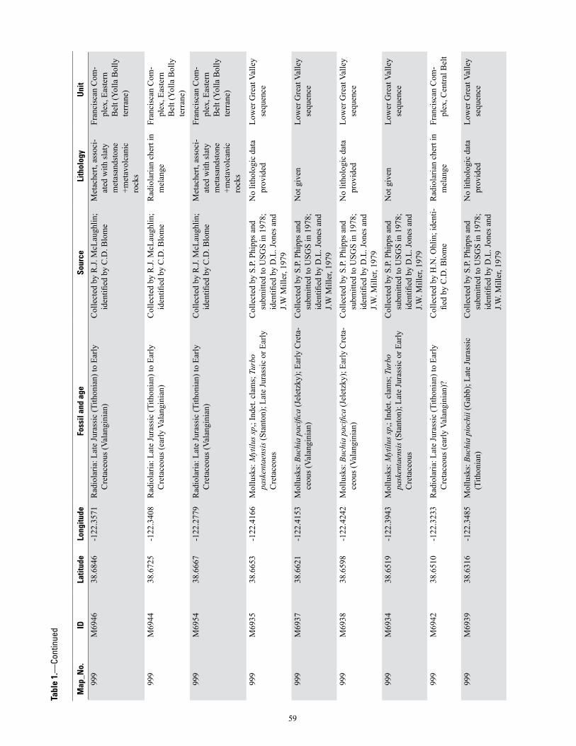
Map
_No.
IDLa
titud
eLo
ngitu
deFo
ssil
and
age
Sour
ceLi
thol
ogy
Uni
t
999
M69
4638
.684
6-1
22.3
571
Rad
iola
ria: L
ate
Jura
ssic
(Tith
onia
n) to
Ear
ly
Cre
tace
ous (
Vala
ngin
ian)
Col
lect
ed b
y R
.J. M
cLau
ghlin
; id
entifi
ed b
y C
.D. B
lom
eM
etac
hert,
ass
oci-
ated
with
slat
y m
etas
ands
tone
+m
etav
olca
nic
rock
s
Fran
cisc
an C
om-
plex
, Eas
tern
B
elt (
Yolla
Bol
ly
terr
ane)
999
M69
4438
.672
5-1
22.3
408
Rad
iola
ria: L
ate
Jura
ssic
(Tith
onia
n) to
Ear
ly
Cre
tace
ous (
early
Val
angi
nian
)C
olle
cted
by
R.J.
McL
augh
lin;
iden
tified
by
C.D
. Blo
me
Rad
iola
rian
cher
t in
mel
ange
Fran
cisc
an C
om-
plex
, Eas
tern
B
elt (
Yolla
Bol
ly
terr
ane)
999
M69
5438
.666
7-1
22.2
779
Rad
iola
ria: L
ate
Jura
ssic
(Tith
onia
n) to
Ear
ly
Cre
tace
ous (
Vala
ngin
ian)
Col
lect
ed b
y R
.J. M
cLau
ghlin
; id
entifi
ed b
y C
.D. B
lom
eM
etac
hert,
ass
oci-
ated
with
slat
y m
etas
ands
tone
+m
etav
olca
nic
rock
s
Fran
cisc
an C
om-
plex
, Eas
tern
B
elt (
Yolla
Bol
ly
terr
ane)
999
M69
3538
.665
3-1
22.4
166
Mol
lusk
s: M
ytilu
s sp,
; Ind
et. c
lam
s; T
urbo
pa
sken
taen
sis (
Stan
ton)
; Lat
e Ju
rass
ic o
r Ear
ly
Cre
tace
ous
Col
lect
ed b
y S.
P. P
hipp
s and
su
bmitt
ed to
USG
S in
197
8;
iden
tified
by
D.L
. Jon
es a
nd
J.W M
iller
, 197
9
No
litho
logi
c da
ta
prov
ided
Low
er G
reat
Val
ley
sequ
ence
999
M69
3738
.662
1-1
22.4
153
Mol
lusk
s: B
uchi
a pa
cific
a (J
elet
zky)
; Ear
ly C
reta
-ce
ous (
Vala
ngin
ian)
Col
lect
ed b
y S.
P. P
hipp
s and
su
bmitt
ed to
USG
S in
197
8;
iden
tified
by
D.L
. Jon
es a
nd
J.W M
iller
, 197
9
Not
giv
enLo
wer
Gre
at V
alle
y se
quen
ce
999
M69
3838
.659
8-1
22.4
242
Mol
lusk
s: B
uchi
a pa
cific
a (J
elet
zky)
; Ear
ly C
reta
-ce
ous (
Vala
ngin
ian)
Col
lect
ed b
y S.
P. P
hipp
s and
su
bmitt
ed to
USG
S in
197
8;
iden
tified
by
D.L
. Jon
es a
nd
J.W. M
iller
, 197
9
No
litho
logi
c da
ta
prov
ided
Low
er G
reat
Val
ley
sequ
ence
999
M69
3438
.651
9-1
22.3
943
Mol
lusk
s: M
ytilu
s sp,
; Ind
et. c
lam
s; T
urbo
pa
sken
taen
sis (
Stan
ton)
; Lat
e Ju
rass
ic o
r Ear
ly
Cre
tace
ous
Col
lect
ed b
y S.
P. P
hipp
s and
su
bmitt
ed to
USG
S in
197
8;
iden
tified
by
D.L
. Jon
es a
nd
J.W. M
iller
, 197
9
Not
giv
enLo
wer
Gre
at V
alle
y se
quen
ce
999
M69
4238
.651
0-1
22.3
233
Rad
iola
ria: L
ate
Jura
ssic
(Tith
onia
n) to
Ear
ly
Cre
tace
ous (
early
Val
angi
nian
)?
Col
lect
ed b
y H
.N. O
hlin
; ide
nti-
fied
by C
.D. B
lom
eR
adio
laria
n ch
ert i
n m
elan
geFr
anci
scan
Com
-pl
ex, C
entra
l Bel
t
999
M69
3938
.631
6-1
22.3
485
Mol
lusk
s: B
uchi
a pi
ochi
i (G
abb)
; Lat
e Ju
rass
ic
(Tith
onia
n)C
olle
cted
by
S.P.
Phi
pps a
nd
subm
itted
to U
SGS
in 1
978;
id
entifi
ed b
y D
.L. J
ones
and
J.W
. Mill
er, 1
979
No
litho
logi
c da
ta
prov
ided
Low
er G
reat
Val
ley
sequ
ence
Tabl
e 1.
—Co
ntin
ued
59

Map
_No.
IDLa
titud
eLo
ngitu
deFo
ssil
and
age
Sour
ceLi
thol
ogy
Uni
t
999
M69
4138
.621
1-1
22.2
887
Mol
lusk
s: B
uchi
a sp
., La
te Ju
rass
ic o
r Ear
ly
Cre
tace
ous
Col
lect
ed b
y S.
P. P
hipp
s and
su
bmitt
ed to
USG
S in
197
8;
iden
tified
by
D.L
. Jon
es a
nd
J.W. M
iller
, 197
9
No
litho
logi
c da
ta
prov
ided
Gre
at V
alle
y se
-qu
ence
999
M69
4038
.591
9-1
22.2
590
Mol
lusk
s: B
uchi
a pi
ochi
i (G
abb)
; Lat
e Ju
rass
ic
(Tith
onia
n)C
olle
cted
by
S.P.
Phi
pps a
nd
subm
itted
to U
SGS
in 1
978;
id
entifi
ed b
y D
.L. J
ones
and
J.W
. Mill
er, 1
979
No
litho
logi
c da
ta
prov
ided
Low
er G
reat
Val
ley
sequ
ence
999
M69
5338
.388
2-1
22.4
033
Rad
iola
ria: L
ate
Jura
ssic
(Tith
onia
n) to
Ear
ly
Cre
tace
ous (
Vala
ngin
ian)
Col
lect
ed b
y R
.J. M
cLau
ghlin
; id
entifi
ed b
y C
.D. B
lom
eM
etac
hert,
ass
oci-
ated
with
slat
y m
etas
ands
tone
+m
etav
olca
nic
rock
s
Fran
cisc
an C
om-
plex
, Eas
tern
B
elt (
Yolla
Bol
ly
terr
ane)
60
Tabl
e 1.
—Co
ntin
ued