fp7 theme 6 – environment assessment of the interaction
TRANSCRIPT

1
FP7 Theme 6 – Environment Assessment of the interaction between corals, fish and fisheries, in order to develop monitoring and predictive modelling tools for ecosystem based management in the deep waters of Europe and beyond
(CoralFISH)
Collaborative Project (Large-scale integrating project) ACTIVITY 6.2. SUSTAINABLE MANAGEMENT OF RESOURCES Sub-activity 6.2.2. Management of marine environments Topic: ENV.2007.2.2.1.3. Habitat-marine species interactions in view of ecosystem based management in the deep-sea Project coordinator: Dr. Anthony J. Grehan, Department of Earth and Ocean Sciences, National University of Ireland, Galway, IRELAND

2
Assessment of the interaction between corals, fish and fisheries, in order to develop monitoring and predictive modelling tools for ecosystem based management in the deep waters of Europe and beyond
(CoralFISH) Abstract In 2006, the UN General Assembly Resolution (61/105) called upon fisheries management organisations worldwide to: i) assess the impact of bottom fishing on vulnerable marine ecosystems, ii) identify/map vulnerable ecosystems through improved scientific research/data collection, and iii) close such areas to bottom fishing unless conservation and management measures were established to prevent their degradation. In European deep waters, in addition, there is now a need to establish monitoring tools to evaluate the effectiveness of closed areas for the conservation of biodiversity and fish and their impact on fisheries. Currently the tools necessary to achieve these management goals are wholly lacking. CoralFISH aims to support the implementation of an ecosystem-based management approach in the deep-sea by studying the interaction between cold-water coral habitat, fish and fisheries. CoralFISH brings together a unique consortium of deep-sea fisheries biologists, ecosystem researchers/modellers, economists and a fishing industry SME, who will collaborate to collect data from key European marine eco-regions. CoralFISH will: i) develop essential methodologies and indicators for baseline and subsequent monitoring of closed areas, ii) integrate fish into coral ecosystem models to better understand coral fish-carrying capacity, iii) evaluate the distribution of deepwater bottom fishing effort to identify areas of potential interaction and impact upon coral habitat, iv) use genetic fingerprinting to assess the potential erosion of genetic fitness of corals due to long-term exposure to fishing impacts, v) construct bio-economic models to assess management effects on corals and fisheries to provide policy options, and vi) produce as a key output, habitat suitability maps both regionally and for OSPAR Area V to identify areas likely to contain vulnerable habitat. The latter will provide the EU with the tools to address the issues raised by the UNGA resolution. Key Words: Deep-sea coral fish fisheries ecosystem-based-management MPA monitoring predictive-modelling

3
Table of Contents
4
List of participants:
Participant no. Participant organisation name Country 1 (Coordinator)
National University of Ireland Galway (NUIG) Ireland
2 Institute of Marine Research (IMR) Norway 3 Marine Research Institute (MRI) Iceland 4
Institut Français de Recherche pour l'Exploitation de la Mer (IFREMER) France
5
Instituto do Mar - Centro dos Acores (IMAR-Azores) Portugal
6 Hellenic Centre for Marine Research (HCMR) Greece 7
Consorzio Nazionale Interuniversitario per le Scienze del Mare (CoNISMa) Italy
8 Nederlands Instituut voor Ecologie (NIOO) Netherlands 9 Zoological Society of London (IOZ) UK 10 Tromso University (UIT) Norway 11 University of Aberdeen (UNIABDN) UK 12
The Royal Netherlands Institute for Sea Research (NIOZ) Netherlands
13 O'Malley Fisheries (OMALLEY_FISH) Ireland 14 Erlangen University (UNI-ERL) Germany 15 National University of Ireland Cork (NUIC) Ireland 16 Bremen University (UNI-BREMEN) Germany
5
Proposal 1: Scientific and/or technical quality, relevant to the topics addressed by the call 1.1 Concept and objectives The concept for this project came about through the identification of a major lack in knowledge by two current FP6 projects. Both the FP6 DG Fisheries STREP 'Marine Protected areas as a tool for ecosystem conservation and fisheries management' (PROTECT) and the DG Research Integrated Project 'Hotspot Ecosystem Research on the Margins of European Seas' (HERMES) have highlighted the paucity of information concerning the interaction between fish and cold-water coral habitats. A better understanding of the relationship between fish and deep-sea habitats is essential for the evaluation of the impact of marine protected areas on fisheries. CoralFISH will address these issues by bringing together for the first time a unique consortium of deep-sea fisheries biologists, ecosystem researchers/modellers, economists and a fishing industry SME, who will collaborate to collect data from key European marine eco-regions. The marine eco-regions identified by ICES (2004) will likely form the basis for regional cooperation among Member States in the implementation of the European Marine Strategy, the main environmental pillar of any future European Maritime Policy. CoralFISH in assessing the interaction of corals, fish and fisheries on a European wide scale has the following objectives:
i) the development of essential methodologies and indicators for baseline and subsequent monitoring of closed areas,
ii) the better understanding of coral habitat fish-carrying capacity through the integration of fish data into coral ecosystem models,
iii) the evaluation of the distribution of deepwater bottom fishing effort to identify areas of potential interaction and impact upon coral habitat,
iv) the use of genetic fingerprinting to assess the potential erosion of genetic fitness of corals due to long-term exposure to fishing impacts,
v) the construction of bio-economic models to assess the impact on fisheries o various management measures adopted to protect coral habitat.
In addition, during a HERMES technical meeting in March (this year) with Unit B1 (International Policy and Law of the Sea) and officers form DG RTD and DG ENV to discuss (1) UN Resolution 61/105 on bottom fishing impacts and (2) Marine genetic resources, it was clear that the management tools required to achieve sustainable fisheries in the High Seas are not yet available. The UNGA Resolution called upon fisheries management organisations worldwide to: i) assess the impact of bottom fishing on vulnerable marine ecosystems, ii) identify/map vulnerable ecosystems through improved scientific research/data collection, and iii) close such areas to bottom fishing unless conservation and management measures were established to prevent their degradation. CoralFISH also has a major objective of providing the EU with the tools to address the issues raised by the UNGA resolution. It will approach this by building on habitat suitability modelling studies undertaken at regional scale by NUIG (Wilson, 2006; Guinan, 2007) and globally by IOZ (Clarke et al., 2006). A key output will be the production of:
vi) habitat suitability maps both regionally and for OSPAR Area V to identify areas likely to contain vulnerable habitat.
1.2 Progress beyond the State of the Art
6
WP 1 Regional cold water coral settings Cold-water coral habitats including stony coral reefs and octocoral/antipatharian gardens (CWCH) live in cold oceanic water, inhabit hard substrates and feed on zooplankton or particulate organic matter in the water to meet their nutritional requirements. They harbor a diversity of associated species that rivals that of tropical coral reefs and may form important habitats for commercially important fish (Freiwald et al. 2004). Thanks to the advances in deep-sea exploration performed by the latest generation of acoustic devices and remotely operated vehicles, CWCHs have been located during extensive seafloor mapping along the Northern and Eastern Atlantic continental margins (from several recent and on-going National and International research programs, eg. Hermes, Echomound/Geomound, Exocet, MarBef, CoML, Censeam, Marov) and recent focused oceanographic expeditions in the Mediterranean (Taviani et al, 2005, Corselli et al., 2006, Freiwald 2007). These reef-building species (i.e. azooxanthellate Scleractinia) can occur on the seafloor as individual corals, isolated colonies, small to large reefs or three dimensional structures resulting in many shapes and sizes (from small scale low relief, a few metres high and tens of metres across, to prominent morphologies, hundreds of metres tall and a few kilometres across, called giant carbonate mounds). Where CWCH, including reefs and carbonate mounds tend to be found, the main associated environmental features include; some hard substrata (for the initial settlement of the coral larvae), nutrient enriched water masses (supplying food for coral growth) and strong bottom currents often topographically driven (keeping the polyps from sediment burial). Indeed, the most important reef development controlling factor seems to be the interplay between local hydrography and sedimentary dynamics that have a strong influence on their growth and therefore on the resultant morphologies occurring at the seafloor (De Mol et al, 2007; Huvenne et al., 2005; Wheeler et al., 2007; White et al. 2007, Sanchez et al. in press). In the Atlantic, Lophelia pertusa reefs and carbonate mound provinces have been recorded and studied (eg. Zibrowius, 1980, Freiwald 2002, Wheeler et al., 2007). The latter studies have dealt with habitat characterization and offer a base data set for comparison with different CWC assemblages, geomorphological and environmental settings. Octocoral and antipatharian habitats have not been extensively studied in the NE Atlantic, although recent investigations in the NW Atlantic and Pacific have identified these as having a significant affect on benthic biodiversity and are associated with commercial species of fish and shellfish (e.g. Stone, 2006). Within the Bay of Biscay, data on scleractinian CWC frame-building occurrences, anthipatharians, gorgonians and large sponges have come mainly from the demersal fishery, The corals are located primarily on the interfluves of the canyons (Joubin, 1922; Le Danois, 1948; Van Rooij et al, 2007); however, the distribution of the corals along the margin, their link with particular topography, the extension and spatial patterns of the coral communities (e.g. reefs, scattered colonies, etc.) is poorly known. The Bay of Biscay is a complex area, where important and numerous canyons bound the NE shelf edge, with consequent up and downwelling with important oceanographic features including: the North Atlantic Drift (NAD), the Mediterranean OverFlow (MOW), strong tidal currents, SW to NW swells and internal waves. In the south of the bay there have been past occurrences of over pressured fluids. The variability of both bottom currents and water masses, associated with the vast submarine canyon system, could play an important role in determining the benthic habitat distribution and development, as well as in shaping the associated geomorphological expression. Within Icelandic waters, CWCHs (predominately L. pertusa) are mainly confined to the Reykjanes Ridge and near the shelf break off the South Iceland coast, mostly within 500 - 600 m depth (Steingrimsson et al., 2006). So far, only relatively few potential coral grounds have been surveyed. Although there is evidence that large coral grounds have already been destroyed by fishing, unimpacted corals have been found in three locations, and these have been already protected by establishment of MPAs. Many more potential coral areas have been discovered

7
during multibeam surveys. It is urgent to investigate them in order to locate unimpacted coral grounds and subsequently ensure their protection. Large quantities of sponges (sponge grounds) are found mainly off north and east Iceland, at depths of 300-750 m. Sponges are likely to be important in providing habitats for a large number of species of invertebrates and possibly of fish as well. This offers an interesting comparison of habitat interactions for fish and invertebrates in CWC and sponge habitats. There is no information on the shelf break and on the Reykjanes ridge off south and south-west Iceland. For the Azores seamounts, available data on CWCH spatial distribution are scarce and fragmentary (Zibrowius, 1980). Large and dense gorgonian stands were revealed by a recent survey (Braga-Henriques et al., 2006) and at least 110 coral species have been recorded in the Azores, encompassing stony corals (Scleractinia), soft corals (Octocorallia), black corals (Antipatharia) and hydrocorals (Stylasteridae). Most of the available information comes from historical references, material stored in museum collections and coral pieces (sometimes entire specimens) towed up by bottom-fishing gears. Reports from local commercial fishermen often indicate the presence of corals around their fishing areas. A much more exhaustive exploration is required for the deep-sea benthic communities of the seamounts, in order to confirm if they host a distinct benthic fauna or occurrences of peculiar habitats due to their isolation (Rogers, 1994). A recent analysis of historical records of NE Atlantic corals from the continental margin, oceanic islands and seamounts has indicated that seamount communities are distinct but the occurrence of endemic species is lower than expected (Hall-Spencer et al., in press). The marine environment of the Azores Archipelago and its surrounding EEZ of more than 1 million square km is of high conservation and marine biological interest (Santos et al., 1995). A major goal is to assimilate conservation issues in societal development, whilst placing them in the political agenda and prompting a more integrated management of habitats and exploited species of the Azores. In the Mediterranean sea, the presence of living CWCH has been documented only in the last decade in Alboran sea, Straits of Gibraltar, Sicily Channel, Ionian Sea, and the Southern Adriatic Sea (Tursi, 2004, Taviani 2005, Freiwald 2007), although the only example of developed banks so far documented came from the Santa Maria di Leuca province, where a broad area (at least 400km2) affected by mass transport deposits, host CWC communities (L. pertusa and Madrepora oculata) on small scale clustered (and isolated) mound-like features. They are tens to few hundreds of meters length and no more than 25m high, located between 600-900 m water depth (Tursi et al. 2004, Taviani et al., 2005; Corselli et al., 2006). Here the biodiversity of associated fauna is lower than the Atlantic counterparts (Tursi et al., 2004), although still high. The study of such Mediterranean assemblage could develop a new insight into the relationship and differences between the Atlantic and Mediterranean. In addition the presence of scattered samples of octocorals also along the eastern side of the Ionian Sea indicates that the Ionian Sea is an important biological resource for the Eastern Mediterranean sea which is known to be characterized by far more oligotrophic conditions than the western basin. WP 2 Regional deep-water fish and fisheries It is often claimed or hypothesized that deep-water coral reefs and coral gardens (gorgonian forests) serve as feeding place, predator refuge and breeding and nursery habitats for fish, with higher density and diversity than in comparable non-coral fields (Husebo et al. 2002; Costello et al. 2005). Husebø et al. (2002) conducted experimental fishing with long-line and gillnets on the shelf off South-western Norway on and off deep-water coral reefs. The results showed that catches of redfish were significantly higher in coral habitats compared to other habitats. However, the food source was not supplied from the reef, but consisted of advected plankton. Catches of tusk and ling were also higher in the coral habitats compared to the surrounding areas, but not statistically significant. Costello et al. (2005) analysed the occurrence of fish from still photos and video at locations in Norway, north of Scotland and west of Ireland. They concluded that far more fishes

8
and more fish species are associated with Lophelia-reefs than the adjacent seabed. Most of the fish species and abundance in the reef habitat are of commercial importance. Fishermen also report that catches are high in coral areas and these habitats are therefore often targeted with long-lines and gillnets. Additional work that has recorded fish in a more general description of the faunal elements connected to deep-water reef systems include Mortensen et al. 2005, Fosså et al. 2002, and Freiwald et al. 2002. Density and often diversity is often higher also on mineral reefs (e.g. cliffs, rock beds, ship wrecks, artificial reefs). As mineral reefs, corals may primarily be significant as structural habitat elements, not as organisms. Relationship between CWCs and fish will undoubtedly change with depth and between geographical areas.
Deep water fisheries The main deep water fish species commercially exploited in the North East Atlantic are blue ling (Molva dypterygia), tusk (Brosme brosme), roundnose grenadier (Coryphaenoides rupestris), orange roughy (Hoplostethus atlanticus), black scabbardfish (Aphanopus carbo) and deep sea squalids (mainly Centroscymnus coelolepis and Centrophorus squamosus). Blue ling and tusk have been significantly exploited since the 1950s but the majority of fisheries for other deep-water species started in the late 1980s. In EU waters, deep-water fishing was largely unregulated up to the early 2000s. In the Mediterranean Sea, deep-water fishing targets red shrimps (Aristeus antennatus and Aristeomorpha foliacea), Norway Lobster and several fish species are significant by-catch. Fishing for all the above-mentioned species as well as additional species such as monkfish (Lophius spp.) and redfish (Sebastes spp.) may interact with CWC and other sensitive habitats. Fishing methods depend on different local socio-economical factors, resources and regulations, but primarily consist of long-lining, gillnets and trawling from large and small vessels depending on the locality (Holley and Marchal 2004). There are a number of control regulations directly and indirectly concerning deep-water fisheries. In EU waters, total Allowable Catches (TACs) for several species were introduced in 2003 (Council regulation (EC) N° 2340/2002 of 16 December 2002) together with a vessel licensing scheme, an aggregate power and capacity capped to levels observed in the years 1998-2002, and a sampling plan for on-board observers (Council regulation (EC) N° 2347/2002 of 16 December 2002). Further TACs were set for deep-water sharks in 2005 (Council regulation (EC) N° 2270/2004 of 2 December 2004). Deep-water fishing vessels are also now equipped with satellite-based vessel monitoring systems (VMS) in application of Council regulation (EC) N° 1489/97 of 29 July 1997. Vessels fishing in Icelandic waters have been obliged, from 1991, to keep logbook records of all their fishing locations to a spatial resolution of 1’ latitude and 1’ longitude. In the Azores, bottom trawling is forbidden (Council Regulation (EC) N°1568/2005 of 20 September 2005).
Impact of fishing on deepwater corals Impact of fishing on benthic communities on continental shelves has been extensively studied (e.g. Kaiser et al., 2002; Collie et al., 2000). In deep water, over a few past decades, the development of deep-water fishing worldwide has caused an extension of fishing grounds over unexploited areas and previously unimpacted benthic communities (Koslow et al. 2000, 2001; Fossa et al. 2002; Hall-Spencer et al. 2002; Clark et al. 2005). Not only towed gears, but longlines (which can be up to 70 km long) and gillnets are suspected to get entangled in corals and other vulnerable biogenic structures and generate damages. While effects of a single longline is minor compared to a trawl haul, the longterm impact of passive gears can be significant (Mortensen and Buhl-Mortensen 2004). Fisheries impact on CWCs may have started long before for the shallowest coral habitats (Joubin 1922). In the North East Atlantic, only in some areas off the Norwegian coast, quantitative estimates of the proportion of impacted CWC communities have been conducted (Fossa et al. 2002). In Icelandic waters, it is likely that many coral-areas have been destroyed by fishing (Steingrimsson et al. 2006). However no large scale, North East Atlantic wide, comprehensive
9
study of the impact of deep-water fishing on CWC has been attempted. Although some fisheries are still spreading over new fishing grounds (ICES 2006), the rate of expansion of impact on CWC is unknown. In the Mediterranean, there are areas where most corals have been swept out (Northern Ionian Sea) and areas where deep-water fishing is not developed, which pristine status remains to be confirmed. Work under this workpackage will synthetise the distribution of fishing effort and all data from the fishery that can contribute to assess the level of interaction between fishing and cold water corals. WP 3 Developing monitoring indicators: deep water fish occurrence and fisheries impacts Lophelia cold-water reefs offers habitats for a great diversity of other species. Much research effort has been assigned to study the distribution of such reefs especially off the coasts of Europe, where they occur in some places at high densities. It is often claimed or hypothesized that Lophelia reefs and coral gardens (gorgonian or antipatharian forests) serve as feeding places, predator refuges and breeding and nursery habitats for fish. Especially fishers report that catches are high in coral areas and these habitats are therefore often targeted with long-lines and gillnets. Even bottom trawl is used in coral habitats even if this is documented to be highly destructive. However, few studies have specifically addressed the association of fish species and their abundance with Lophelia in the Northeast Atlantic. We know of only two reports, namely Husebø et al. (2002) and Costello et al. (2005). In addition there is a number of papers that have incorporated fish in a more general description of the fauna elements connected to deep-water reef systems (e.g. Mortensen et al. 1995, Fosså et al. 2002, Freiwald et al. 2002). Elsewhere, such as in the Aleutian Islands, N Pacific, 97% of juvenile rockfish and 96% of juvenile golden king crabs have been observed as associated with emergent epifauna such as octocorals and sponges (Stone, 2006). Husebø et al. (2002) conducted experimental fishing with long-line and gillnets on the shelf off South-western Norway on and off deep-water coral reefs. The results showed that catches of redfish were significantly higher in coral habitats compared to other habitats. However, the food source was not supplied from the reef, but consisted of advected plankton. Catches of tusk and ling were also higher in the coral habitats compared to the surrounding areas, but not statistically significant. Costello et al. (2005) analysed the occurrence of fish from still photos and video at locations in Norway, north of Scotland and west of Ireland. They concluded that far more fishes and more fish species are associated with Lophelia-reefs than the adjacent seabed. Most of the fish species and abundance in the reef habitat are of commercial importance. Analysis of high resolution log-book data from the otter-trawl and long-line revealed that many commercially important species e.g. cod (Gadhus morhua), saithe (Pollachius virens) and haddock (Melanogrammus aeglefinus) are commonly caught in coral areas as well. For other species such as redfish (Sebastes marinus), tusk (Brosme brosme), ling (Molva molva) and blue ling (Molva dypterygia) there are indications that these are more common in coral habitats (Steingrimsson and Einarsson, 2004). Preliminary knowledge on bentho-pelagic fauna in the CWC province, Ionian Sea, has been reported in Tursi et al. (2005). During September-October 2005 experimental samplings were carried out with longlines and trawl nets inside the coral habitat and outside where fishery resource exploitation occurs. The depths examined were between 300 and 800 m. Large specimens of rockfish, Helicolenus dactylopterus, and blackspot seabream, Pagellus bogaraveo, were exclusively caught using longlines inside the coral habitat. Data from trawling revealed refuge effects in the coral habitat and fishing effects outside. Greater density and biomass values were obtained inside the coral area than outside. These papers confirm to a certain degree the fishers’ opinion that the deep-water reefs and other coral habitats are good fishing places. However, high densities of fishes on cold-water coral reefs,
10
or in similar habitats such as coral gardens and sponge aggregations, do not necessarily indicate that corals are important fish habitats when considering total stock size. Thus, it is essential to obtain quantitative information on how the distribution of fish is on and off reef habitats to assess the importance of the habitat use by the fish. Acoustics are routinely used for fish stock assessment by many fishery research institutions usually with hull-mounted echo sounders. This is an effective way to obtain medium- to large-scale information on fish distribution. Food is one of the most important governing factors related to the distribution and abundance of fish and most likely also for coral reefs. Experience from numerous dives with ROV indicates that there is high abundance of zooplankton in reef areas especially in shelf environments at 100-300 m depth. Lophelia eat zooplankton in situ (own observations) which is also supported by indirect evidence (Kiriakoulakis et al. 2005). Redfish caught in coral reef habitats also eat zooplankton (Husebø et al. 2002). Therefore we want to describe the zooplankton distribution in relation to the reef habitat. This will gain insight where in the food web the corals are placed and link the planktonic production to the benthic system. Fish and CWC are believed to co-occur but at the very least the interaction is that some fish species are more abundant in CWC habitats (Husebø et al. 2002; Costello et al. 2005), causing some fishers to deliberately target CWC regions. Not only towed gears, but long lines (which can be up to 70 km long) and gillnets are suspected to get entangled in corals and other vulnerable biogenic structures and generate damages. While effects of a single long line is minor compared to a trawl haul, the long-term impact of passive gears can be significant (Mortensen and Buhl-Mortensen 2004). Results from the studies performed under this work package will give new insights into which factors are important in controlling fish distribution patterns and habitat selection. Identifying such controlling factors is important for improved understanding of the ecological mechanisms relevant for fish species. The results will also answer the very topical question of whether or not the coral habitats are important for fish at the population level. WP 4 Developing monitoring indicators: genetic fingerprinting of cumulative long-term
effects of fishing impacts on corals The recovery of populations of coral habitat from the impacts of fishing depends on the severity of impacts, and on their consequences on the mating system, the frequency of recruitment, and genetic variability of the species. Damage to a reef or octocoral garden may be replenished through asexual production of new colonies through fragmentation (e.g. Lophelia) and/or through self-recruitment of sexually produced larvae. Evidence from early genetic studies on Lophelia indicated that in a site heavily impacted by trawling (Darwin Mounds, NE Atlantic) colonies failed to reach a size at which sexual reproduction could take place (Waller & Tyler, 2005) and the population was characterised by the presence of a low number of clones (Le Goff-Vitry et al., 2004) indicating maintenance by asexual reproduction by fragmentation, and implying a lower level of genetic diversity. Similar findings have be found in studies of fishing impacts on the hydroid Sertularia cupressina (Henry & Kenchington, 2004). Recovery and long-term persistence of populations may depend strongly on the evolutionary potential that has been demonstrated to be linked to the role of clonal reproduction and diversity in clonal marine organisms (Pearson et al., 2002; Hughes and Stachowicz, 2004; Reusch et al, 2005; Foster et al., 2007). and that is thought to be tightly linked to the level of genetic diversity present in the population (Pimm 1986, Willi et al. 2006, Allendorf 1986, O'Brien 1994). Finally, in cases where large-scale destruction of coral habitat has taken place, recovery will depend on long-distance dispersal of larvae from remote source populations. Workpackage 4 will, for the first time, explicitly investigate the relationship between fishing impacts and the genetic structure of coral populations. It will use state-of- the-art genetic methods to examine the prevalence of sexual vs asexual reproduction and whether fishing impacts can cause
11
erosion of the genetic variation in coral populations. Molecular phylogenetic methods will also be used to confirm the identification of coral species and to investigate regional and global patterns of coral evolution in deep water, through collaboration with other international programmes (e.g. Census of Seamounts). WP 5 Developing monitoring indicators: ecosystem function, modeling and metrics To understand and predict the dynamics of CWCH, an integrated and quantitative view of the energy flows within the coral system and associated fauna is required. To date, however, research on cold-water corals has been dominated by video transects to discover their distributions and associated biodiversity. Quantitative data on CWCs are scant (for example, there are no published records on the biomass of CWC in a reef!). A CWC reef typically consists of distinct layers. The top layer is formed by coral branches that are completely covered by living coral tissue (Freiwald et al. 2004), and harbors few other organisms. Below the living coral layer in the reef is a layer in which the coral has died or has been completely overgrown by fauna such as sponges (Freiwald et al. 2004, Van Soest and Lavaleye 2005) and on which mobile epifauna can be found. The coral structure enhances sediment accumulation and below the overgrown dead coral, the coral structure has been filled with sediment, again inhabited by different fauna. Deciphering the food web relations in such a complex system is a notorious problem in food web research, and it is often achieved by combining so-called inverse mathematical models with data. Traditionally, models that include fish use the ECOpath approach (Pauly et al., 2000; Sanchez and Olaso, 2004), which needs, for each of the groups, full specification of many parameters, such as diet composition, ingestion, production, etc. In many instances, these quantities are unknown or only partially known. Foodweb pathways can be reconstructed using linear inverse analysis based on mass balancing (Vezina and Platt, 1988; Oevelen et al., 2006). These inverse models are based on the same principles as ECOpath, but they are more general. They can cope with a larger variety of data types and they do not require as much input: where data are lacking, these models calculate uncertainty in the food webs. Although within the EU HERMES project, modeling of the food web within cold-water corals is being carried out, this does not include the fish component which is essential to understand the full reef dnamic. WP6 Developing tools for ecosystem management: habitat suitability modelling Over the last 50 years studies of the diversity and structure of the deep-sea communities of the continental margins have shown a number of common patterns, including (Gage & Tyler, 1991; Carney, 2005): a decrease in biomass and abundance of species with increasing depth; the zonation of species composition of communities with increasing depth; a parabolic pattern of species richness with depth, with a peak in diversity at between 1,000 – 3,000m, depending on location and the taxon studied. These studies were based on surface-deployed sampling equipment such as dredges, trawls and corers with little information on the specific habitat associations or environmental requirements of the fauna. Even in the present day only some 0.0001% of the deep-seafloor has been explored (Gjerde, 2006). In comparison, specific habitats in the deep sea such as cold-water coral reefs, seamounts and the slopes of oceanic islands have received almost no attention by researchers because of the difficulties in sampling rugged topography with surface-deployed gear. These environments are sometimes characterised by highly diverse benthic communities in which corals are often important ecosystem engineers (Rogers, 1999; Roberts et al., 2006). Over the past decade there has been increasing concern related to expanding deep-sea fisheries targeting deep-sea habitats (Koslow et al., 2001; Fossa et al., 2002; Freiwald et al., 2004; Clark et al., 2006; Morato et al., 2006). Management of fisheries to avoid damaging sensitive habitats is severely hampered by a lack of data on where these habitats are likely to occur with respect to fishing activities. The full geographical range of CWC is not known but known coral locations have been compiled (e.g. (Rogers 1999) and distribution can be predicted by habitat models whereby the observed distribution of a species or group of species is compared to the background distribution of environmental factors allowing the prediction of the general distribution
12
of the target species based on global or regional environmental datasets. This approach, known as habitat suitability modelling, has been in development since the 1970s (Guisan & Thuiller, 2005) and may be an ideal tool for managers and conservationists, especially for deep-water habitats where our knowledge on cold-water corals distribution is constrained by the expense and logistical challenges of any basic survey work. A variety of approaches are now used for habitat suitability modelling but the one that has been applied to deep-sea corals on a regional (Bryan & Metaxas, 2007) or global scale (Clark et al., 2006) is Environmental Niche Factor Analysis (ENFA; Hirzel et al., 2001). This model is ideal for datasets on distribution of deep-sea species as it requires presence data but does not require reliable absence data (Clark et al., 2006). In this workpackage, Habitat Suitability Modelling will be used to identify which environmental factors are important in determining the distribution of CWCs. Furthermore, these models will be used to predict the distribution of CWCs throughout OSPAR Area V and part of area I as a basis for future investigations of CWC ecology and as a tool for fisheries managers in application of ecosystem-based management of deep-sea fish resources. WP 7 Developing tools for ecosystem management: identification of sensitive and
essential/preferred fish habitat A challenge exists to optimise systems for the management of data generated and derived in the process of classifying CWC habitats. A variety of datasets will be generated and derived including high resolution multibeam bathymetric and backscatter imagery and other products, benthic and species data, high frequency side-scan sonar data, sub-bottom profile data, oceanographic data and video imagery. Information technology plays an important role in managing and adding value to these datasets and their derivatives in an integrated way. This work-package serves an important function in applying state of the art standards (e.g. ISO 19115 and 19139 metadata standards) and technologies (e.g. OGC compliant web mapping technologies) for data handling. It provides a means of offering the best available data in a format that is readily accessible to researchers. It also provides for testing and comparing a diversity of software environments for geo-statistical analysis of fisheries data.

13
Data access and processing: A key issue pertaining to data access relates to the availability of long term database environments for scientists to publish, retrieve and archive quality data and metadata. This issue is addressed in CoralFish by adopting PANGAEA (Publishing Network for Geoscientific and Environmental Data) as the core project repository framework for storing and distributing project generated geo-referenced data. Data can be retrieved by the PANGAEA search engine and a number of OGC and ISO compliant interfaces . The Advanced Retrieval Tool (ART) is designed for data discovery and to retrieve and download individually configured data sets. PANGAEA is designed to cater for the range of datasets that will be generated by CoralFish, including biological, geochemical and ship track data. It provides access to multiple complimentary data holdings such as data generated by the HERMES and EUR-OCEANS (FP6),), ECOMOUND and ACES (FP5) projects. Each dataset can be identified, shared and published by a persistent Digital Object Identifier (DOI). The system is operated in compliance with the Berlin Declaration on Open Access to Knowledge in the Sciences and Humanities which is a follow up to the Budapest Open Access Initiative. The policy of data management and archiving follows the Principles and Responsibilities of ICSU World Data Centres. GIS modelling: Geographic Information Systems (GIS) is an important tool for the integration, analysis and visualisation of marine data (Wright & Bartlett, 2000). GIS can facilitate dynamic links between different models and analytical processes. As such it is considered to hold the key to better management and of the numerous spatially related problems identified by fisheries scientists
Fisheries Habitats Model output data
Data
PANGAEA Catalogue
PANGAEA Repository
DBMS
QC
Fisheries & Habitat Portal /GIS model
ATLAS
Web GIS Engine
Geostatistical Tools (from T7.1 and 2.6)
T10.44
T7.2 7.4
T2.6 7.2
T7.3 7.4 T.7.3
Data
Fisheries and Habitats Data Output Data
Project Partner External User
14
(Hinds, 1992; Loayza & Sprague, 1992). Key issues to be dealt with in the application of GIS to fisheries management are summarised by Meaden (2000) as:
o The functional design of 4D databases and visualisations o The definition of fuzzy boundaries o Dealing with diverse temporal and spatial scales o The diversity and fragmentation of fisheries data
Opportunities presented by existing applications of GIS in general fisheries management include some specific areas that can be of relevance to CoralFish (Valavanis, 2002), e.g. integration of RS, surveyed, statistical and species life history data. Depending on the availability and quality of the latter this can lead to seasonal mapping of species population dynamics and in particular areas of habitat vulnerability. CoralFish provides an opportunity to make progress on many of these issues. In particular, advances will be made in simulating relationships between fish distribution and abundance and environmental parameters at the meso CWC habitat level. Geo-statistical analysis and techniques such as kriging and will be applied in CoralFish to fisheries data to analyse data distributed in the study areas and to estimate values of variables at non-sampled locations. Software such as GenStat 8.0 will be combined with ESRI’s ArcGIS Spatial Analyst to provide powerful predictive tools. Fisheries contour maps will be generated and innovative techniques will be indentified to integrate this data with habitat models to provide a basis for trend analysis. Such techniques can e.g. include geowieghted regression, Data visualisation: The CoralFish approach builds on a number of previous projects, which have made significant advances in the area of data sharing and integration for marine environmental datasets, as advocated by the INSPIRE Spatial Data Infrastructure (SDI) framework. CoralFish will incorporate the OGC Web Map Service (WMS), which was significantly advanced in the IST DISMAR project (Hamre et al., 2005) and which is being progressed in InterRisk through the application of Web Feature Service (WFS) and Web Coverage Service (WCS). WMS will be utilised here for data visualisation, facilitating the development of an online fisheries and habitat atlas. The webGIS envisioned from this work task will be targeted towards fisheries management applications and an end user community involving scientists and policy makers with an interest in ecosystem interactions. Novel geo-visualisation techniques will be incorporated e.g to assist in delineation of geomanagement areas. WP 8 Developing tools for ecosystem management: economic models and policy advice Currently there is insufficient knowledge of how fish species relate to deep water coral habitats in order to perform applied bioeconomic studies in these ecosystems. By inferring how coral is affected by fishing, and how commercial stocks again are affected by changes in the coral coverage, it is nonetheless possible to design models both theoretically and by statistical methods based on time series data (see for instance Barbier (2000) for examples with regard to mangroves). Theoretical models of interactions between resources such as fish stocks and renewable or non-renewable habitats show how vulnerable habitat can be when affected by fishing activity (Kahui and Armstrong 2007, Reithe and Armstrong, 2007). In Figure 1 and 2 we see examples of three different scenarios of fish interactions with habitat. The dashed line shows no interaction between fish and habitat, i.e. the two are independent, the grey line describes an interaction where the habitat has a positive effect upon the fish, i.e. there is commensalism, while the unbroken line illustrates the situation where both habitat and fish have some positive effect upon one another, i.e. there is symbiosis. In both figures there is an assumption of open access as regards fishing activity.

15
In this kind of management scenario, fishing effort keeps increasing as long as profits are positive. Furthermore, fishing effort is assumed to have some damaging effect upon the habitat.
Figure 1 shows how a renewable habitat develops over time for these three interaction scenarios: habitat declines for all three cases, moving towards a lower equilibrium level where no interaction between fish and habitat gives the highest habitat level, while commensialism gives the lowest. Habitat fluctuations also differ, with the independent case showing the lowest fluctuations, while symbiosis has the highest. Figure 2 shows how a non-renewable habitat develops over time for these three interaction scenarios: habitat is depleted over time for all three scenarios, with habitat in the cases with commensalism and symbiosis being depleted first.
Both non-renewable and renewable habitat, interactions between fish and habitat have a detrimental effect upon habitat coverage over time. This is because the open access nature of the fishery makes any positive effect that the habitat may have upon the fish stock, result in greater effort in the fishery, which again damages the habitat. Though open access in fisheries is not uncommon, it is of interest to study how other management regimes will affect habitat coverage, as well as fish stocks. The existing theoretical models focus on private property (Swallow 1990) or open access. In many fisheries, if not most, management is somewhere between these two outer limits. Choice of management may clearly have very varying consequences for coral coverage. Hence by studying more realistic management regimes in our bioeconomic models a greater understanding can be
Habitat development
0
0,2
0,4
0,6
0,8
1
1,2
1,4
1 5 9
13
17
21
25
29
33
37
41
45
49
53
57
Time
Independent
commensialism
Symbiosis
Habitat development
0
0,2
0,4
0,6
0,8
1
1,2
1,4
1
24
47
70
93
116
139
162
185
208
231
254
277
300
323
Time
Independent
commensialism
Symbiosis
Figure 1. Fishery effects upon renewable habitat over time.
Figure 2. Fishery effects upon non- renewable habitat over time.
16
obtained of how deep water coral has been affected by fishing activities. Furthermore inferences can be made with regard to reduction in deep water coral coverage historically, as well as into the future, given no change in management strategies. Alternative management options, such as restricted access, reference points and marine protected areas should be investigated, but have as of yet only received scant attention with regard to habitat-fisheries interactions (Armstrong, 2007). Other issues such as how subsidies affect the results is also of interest. Bioeconomic models have also traditionally been single species and non-spatial, though in recent years there has been a growing interest in spatial analysis, especially with regard to the analysis of marine protected areas (Smith and Wilen 2002, Sanchirico and Wilen, 1999, 2001, 2002). Opening for the inclusion of heterogeneous space is therefore desirable, and could be introduced via introducing habitats of different quality or type (Armstrong, 2007), which would expand the management analysis further to for instance transferable habitat quotas (see Holland and Schnier 2006 for some initial analysis). Heterogeneous space also allows for more inclusive models with regard to life-cycle interactions with different habitats. Hence there is a vast knowledge gap that can be reduced with theoretical modelling. Based on this theoretical modelling, initial applied analysis can be undertaken. Given sufficient data on the commercial species in question (coral coverage, biological parameters, biomass estimates, harvest data, cost and revenue data and more), simulation and analysis of how different management options (such as open and restricted access, property rights, reference points, spatial/time closures and transferable quota management schemes) affect fish stocks and coral will be forthcoming. The results can be fitted into a broader framework to investigate ecosystem management approaches from a theoretical and empirical perspective. Such an approach can then be evaluated against existing political and social structures for the respective study area. The integration of results can then be amalgamated into a concrete set of policy suggestions that give guidance and insights to policy makers and all relevant stakeholders. .
17
1.3 S/T methodology and associated work plan
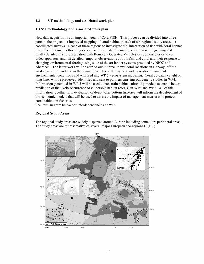
1.3 S/T methodology and associated work plan New data acquisition is an important goal of CoralFISH. This process can be divided into three parts in the project : i) improved mapping of coral habitat in each of six regional study areas, ii) coordinated surveys in each of these regions to investigate the interaction of fish with coral habitat using the the same methodologies, i.e. acoustic fisheries survey, commercial long-lining and finally detailed in situ observation with Remotely Operated Vehicles or submersibles or towed video apparatus, and iii) detailed temporal observations of both fish and coral and their response to changing environmental forcing using state of the art lander systems provided by NIOZ and Aberdeen. The latter work will be carried out in three known coral locations in Norway, off the west coast of Ireland and in the Ionian Sea. This will provide a wide variation in ambient environmental conditions and will feed into WP 5 - ecosystem modeling. Coral by-catch caught on long-lines will be preserved, identified and sent to partners carrying out genetic studies in WP4. Information generated in WP 5 will be used to constrain habitat suitability models to enable better prediction of the likely occurrence of vulnerable habitat (corals) in WP6 and WP7. All of this information together with evaluation of deep-water bottom fisheries will inform the development of bio-economic models that will be used to assess the impact of management measures to protect coral habitat on fisheries. See Pert Diagram below for interdependencies of WPs. Regional Study Areas The regional study areas are widely dispersed around Europe including some ultra peripheral areas. The study areas are representative of several major European eco-regions (Fig. 1)

18
Fig. 1. Map showing the major European eco-regions and the location of CoralFISH study
areas. (biogeographical provinces) and as such can be expected to yield a broad picture of the ways in which fish interact with corals in European waters. Below find an overview of each locality. 1. Northern Norway Study Area: Geology and Morphology
The Norwegian study sites are located in the Træna/Røst area off northern Norway. This area represents the eastern part of the Norwegian Sea, ICES biogeographical region D. The Norwegian Sea comprises a great range of benthic habitats and environmental conditions. At the large scale, fjords, open coast, continental shelf, shelf break, slope and the deep ocean floor are mega-habitats. The deep ocean floor covers the vast majority of the Norwegian Sea, whereas the continental shelf extends up to 200 km from the coast. Morainic deposits, pockmarks and ploughing marks from iceberg scouring are found on large parts of the shelf and soft-layered clay is commonly found in the deeper parts. Gravely and sandy bottoms are found near the shelf-break and on ridges where the currents are strong and the sedimentation rates low. Exposed crystalline bedrock is most frequent near the coast and in the fjords. Both morainic deposits and outcropping bedrock are suitable substratum for habitat forming organisms such as corals and sponges.
Hydrology Atlantic Water is the main heat source of the Norwegian Sea. This water follows the Norwegian Coastal Current (NCC) along the continental slope and splits in two branches into the Barents Sea. This water has a salinity above 35‰ and a temperature normally between 4 and 6 °C (see Skjoldal (2004) and Sætre (2007)).
Coral /reef habitat
Cold-water coral reefs formed by Lophelia pertusa are common in the mid Norwegian shelf (Mortensen et al. 2001). This area contains the highest density and the largest and most developed reefs that we know of. The largest reef-complex known the Røst Reef and the Træna reefs are located in this region. Thousands of reefs have been located and mapped which makes this area well suited for the proposed studies.
Commercial Fisheries and Fish fauna
Shelf fisheries in the study area include all-year or seasonal trawling, long line and gillnet exploitation of demersal resources. Target species include a wide range of gadoids and other benthic and benthopelagic species such as redfish (Sebastes), Greenland halibut (Reinhardtius hippoglossoides), and greater silver smelt (Argentina silus). Some of these fisheries are conducted in or near reef structures. On the coral reefs, redfish (Sebastes spp.), tusk (Brosme brosme) and ling (Molva molva) are common (Husebø et al. 2002). These are targeted by long line and gill net fishers.
MPA’s Bottom trawling has damaged many reefs in the Norwegian Sea and as a result the Norwegian government has issued regulations for the protection of coral reefs from bottom trawling (Fosså et al. 2002). At present there are three offshore coral MPAs in the region (Sula, Iverryggen, and Røst).
CoralFISH survey strategy
WP 3 Multi beam echosounder mapping; fisheries and plankton acoustic echosounder transects on and off reef; towed multi frequency acoustic plankton sampling on and off reef; ROV/tripod visual transects on and off reefs. NIOZ and Aberdeen lander small scale observations in reef habitat; Longline fishing in and off reef areas.
2. Iceland
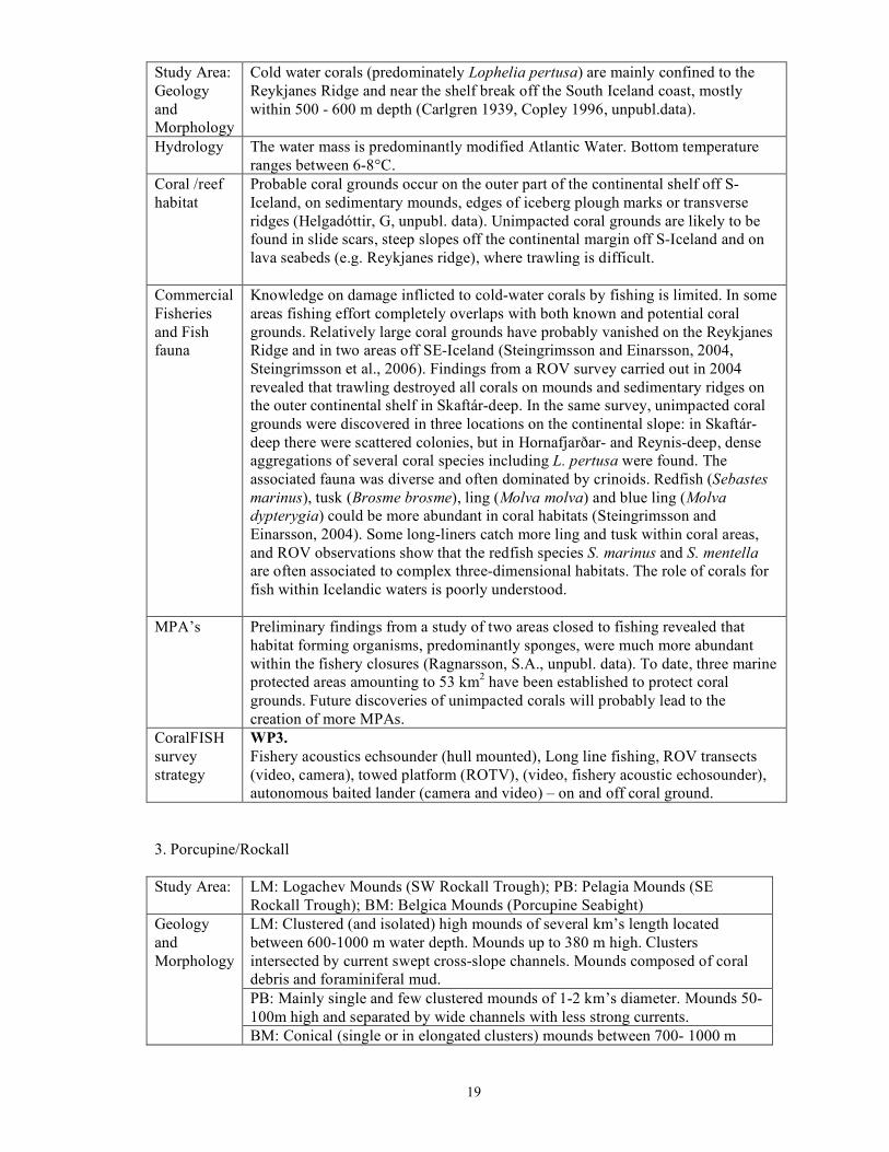
19
Study Area: Geology and Morphology
Cold water corals (predominately Lophelia pertusa) are mainly confined to the Reykjanes Ridge and near the shelf break off the South Iceland coast, mostly within 500 - 600 m depth (Carlgren 1939, Copley 1996, unpubl.data).
Hydrology The water mass is predominantly modified Atlantic Water. Bottom temperature ranges between 6-8°C.
Coral /reef habitat
Probable coral grounds occur on the outer part of the continental shelf off S-Iceland, on sedimentary mounds, edges of iceberg plough marks or transverse ridges (Helgadóttir, G, unpubl. data). Unimpacted coral grounds are likely to be found in slide scars, steep slopes off the continental margin off S-Iceland and on lava seabeds (e.g. Reykjanes ridge), where trawling is difficult.
Commercial Fisheries and Fish fauna
Knowledge on damage inflicted to cold-water corals by fishing is limited. In some areas fishing effort completely overlaps with both known and potential coral grounds. Relatively large coral grounds have probably vanished on the Reykjanes Ridge and in two areas off SE-Iceland (Steingrimsson and Einarsson, 2004, Steingrimsson et al., 2006). Findings from a ROV survey carried out in 2004 revealed that trawling destroyed all corals on mounds and sedimentary ridges on the outer continental shelf in Skaftár-deep. In the same survey, unimpacted coral grounds were discovered in three locations on the continental slope: in Skaftár-deep there were scattered colonies, but in Hornafjarðar- and Reynis-deep, dense aggregations of several coral species including L. pertusa were found. The associated fauna was diverse and often dominated by crinoids. Redfish (Sebastes marinus), tusk (Brosme brosme), ling (Molva molva) and blue ling (Molva dypterygia) could be more abundant in coral habitats (Steingrimsson and Einarsson, 2004). Some long-liners catch more ling and tusk within coral areas, and ROV observations show that the redfish species S. marinus and S. mentella are often associated to complex three-dimensional habitats. The role of corals for fish within Icelandic waters is poorly understood.
MPA’s Preliminary findings from a study of two areas closed to fishing revealed that habitat forming organisms, predominantly sponges, were much more abundant within the fishery closures (Ragnarsson, S.A., unpubl. data). To date, three marine protected areas amounting to 53 km2 have been established to protect coral grounds. Future discoveries of unimpacted corals will probably lead to the creation of more MPAs.
CoralFISH survey strategy
WP3. Fishery acoustics echsounder (hull mounted), Long line fishing, ROV transects (video, camera), towed platform (ROTV), (video, fishery acoustic echosounder), autonomous baited lander (camera and video) – on and off coral ground.
3. Porcupine/Rockall Study Area: LM: Logachev Mounds (SW Rockall Trough); PB: Pelagia Mounds (SE
Rockall Trough); BM: Belgica Mounds (Porcupine Seabight) LM: Clustered (and isolated) high mounds of several km’s length located between 600-1000 m water depth. Mounds up to 380 m high. Clusters intersected by current swept cross-slope channels. Mounds composed of coral debris and foraminiferal mud. PB: Mainly single and few clustered mounds of 1-2 km’s diameter. Mounds 50-100m high and separated by wide channels with less strong currents.
Geology and Morphology
BM: Conical (single or in elongated clusters) mounds between 700- 1000 m

20
water depth. Mounds have exposed steep western seaward flank and a sedimentary, buried eastern landward flank. Mounds between 70-190 m high LM: Average bottom temperature about 9°C with a diurnal temperature fluctuation of 2°C. Bottom currents on mound summit maximum ~30 cm/s with median ~10 cm/s. Residual current on summit directed SE. PB: Average bottom temperature of 9.5°C with semi-diurnal fluctuation of ~1°C. Bottom currents on summit maximum 30 cm/s with average between 10-20 cm/s. Residual current directed poleward.
Hydrology
BM: Bottom temperatures between 8.5-9.5°C. Bottom currents vary locally. Mostly exceeding 15 cm/s for only 7-15% of the time but locally 49 % of the measured time. Residual current direction variable but locally along-slope and poleward. LM: Summit of mounds (800 m depth) with a very dense and extensive coverage of (live and dead) coral framework ca 0.5-1 m high. Flanks of mound have no coral. PB: Summit of mounds (650 m depth) covered with relatively open (live and dead) coral framework.
Coral /reef habitat
BM: Corals (Lophelia and Madrepora) and associated fauna (sponges, bryozoans, octocorals) occur on seaward flank but not on landward side. Dense coverage of live corals so far only found on Galway Mnd. LM: Synaptobranchus kaupii and Moridae dominant fish on Porcupine and Rockall Banks PB: Synaptobranchus kaupii and Moridae dominant fish on Porcupine and Rockall banks
Fish fauna
BM: Moridae dominant fishes on the Porcupine Seabight LM: Blue ling, anglerfish, red crab fishery PB: Orange roughy along slope; spawning aggregations on some mounds in February
Commercial Fisheries
BM: Hake LM: NEAFC fisheries closures imminent PB: CFP closed area to prevent fishing roughy on mounds; candidate Special Area of Conservation to protect corals
MPA’s
BM: Candidate Special Area of Conservation to protect corals LM: WP3 Fisheries acoustic echosounder transects; Longline fishing;ROV transects - on and off mound; WP5 NOIZ and AberdeenLander studies continuing work begun previously in HERMES and other projects PB: WP3 Fisheries acoustic echosounder transept; Longline fishing, ROV transects - on and off mounds - one example where corals have been removed by trawling
CoralFISH survey strategy
BM: WP3 Fisheries acoustic echosounder transept; Longline fishing, ROV transects - on and off mounds - one example to establish a baseline in an SAC.
4. Bay of Biscay (BoB) Study Area: Geology and Morphology
Occurrences of scleractinian corals along the Bay of Biscay slope have been recorded since the 19th century (Studer 1879 in Zibrowius 1980; Joubin, 1922; Le Danois, 1948) but their distribution, biodiversity and ecosystem structure are not yet well known. The upper slope and the outer shelf of the BoB extend over 7 ICES divisions and the European Marine Strategy biogeographical region G. From the Goban spur to the Capbreton canyon, the succession of interfluves and

21
deep canyons (Bourillet and Loubrieu, 1995; Le Suavé et al., 2000; Bourillet et al., 2003) have shaped the passive margin (average slope of 5°) due to erosion processes. From there onwards to the Ortegal Terrace, the steeper slope (>8°) is bounded downward by the North Pyrenean overthrust responsible of past over pressured fluids (Bourillet et al., 2007). Corals occur all along the upper slope of the BoB but only on specific geomorphological landscapes.
Hydrology The BoB is a complex area with the North Atlantic Drift (NAD), the Mediterranean Overflow (MOW), seasonal surface currents, strong tidal currents especially at the outer shelf of the Western Approaches, SW to NW swells, internal waves and upwelling.
Coral /reef habitat
The occurrence of Lophelia pertusa randomly sampled by scientists or occasionally collected by fishermen (Van Rooij et al., 2007) suggests a bathymetric distribution between 200 and 1700m, morphological located on flat areas such as interfluves or summit of banks. Other associated engineer species are anthipatarians, gorgonians and large sponges. Yet, the distribution of the corals along the margin, their link with particular topography, the extension and spatial patterns of the coral communities (e.g. reefs, scattered colonies) is very poorly known. Recent studies revealed the co-occurrence of hard bottoms identified as carbonate-crusted banks with protrusions hosting dense communities of giant oysters (Huvenne et al., 2002).
Commercial Fisheries and Fish fauna
The BoB is not a major area for typical deepwater fishing because catch rates of several deepwater species (roundnose grenadier, blackscabbard fish and deepsea squalids) are small (Ehrich, 1983). However, over recent years, some targeted fishing for orange roughy has developed and generated significant landings. Evidence from unpublished information on the fisheries suggest that interfluves between two canyons are targeted areas for the orange roughy fishery and occasional collection of coral.
MPA’s There is not yet a MPA on the Bay of Biscay’s outer shelf or upper slope. The Spanish Environmental Ministry and the French Agency for MPAs plan to define sectors of development of the Natura 2000 network for June 2008 in the BoB: Le Danois Bank area as the first MPA of the Cantabrian Sea; the Avilés canyon and the Galicia Bank could be further candidates; targeted canyon heads and a large sector of the continental margin by the French Agency. CoralFISH results will contribute to the enhancement of the scientific knowledge of these areas and will be used to define the new MPAs.
CoralFISH survey strategy
WP1 Habitat mapping (MBES, video and sampling) at meso scale on 3 sites selected thanks to previous EEZ geophysical data.. WP1, WP2, WP3 & WP4 Habitat mapping (ROV, video and MBES, sampling) at micro scale on targets selected thanks to meso-scale work and VMS data analysis (WP2)
5. The Azores Study Area: Geology and Morphology
The Azores Archipelago (36-40ºN, 24-32ºW) is located in the North East Atlantic about 1,800 km from Portugal. The vast extension of the nine islands defines an immense exclusive economic zone (EEZ) of 1.1 million km². The archipelago forms the Autonomous Region of Azores, one of the ultra-peripheral regions of Europe. This region is located in a zone of complex geology, a junction where three major plates join. The seafloor is mostly deep but several seamounts, a fraction of the Mid Atlantic Ridge, and islands slopes comprise the shallowest part of the ocean.
Hydrology The Azores are strongly influenced by the Gulf Stream western boundary current,

22
which transports warm water of equatorial and tropical origin into the colder northern water. These current patterns result in high surface salinity in the open Ocean, and high temperature and low nutrient regimes, which typify the Azores (Santos et al., 1995). Upwelling phenomena are frequently observed around the Azores islands. The complex topography of the banks and seamounts also produces other oceanographic important phenomena, for example, jets or trapping currents around seamounts. Average surface sea temperature varies 15-20°C during winter and 20-25°C during summer (Martins et al., 2001).
Coral /reef habitat
Approximately 110 corals species have been recorded mainly in the steep volcanic biotopes of the insular slopes and offshore seamounts. However the knowledge of their distribution is very limited. Available data sources include historical records (Zibrowius, 1980), museum collections, interviews of fishermen and occurrence records from scientific missions. Multibeam and sidescan surveys have been carried out in few places (e.g. Mitchell et al., 2003, Luis et al., 2006, Stretch et al., 2006). In a recent survey at the Condor seamount, large and dense gorgonian stands were revealed. The community was dominated by Viminella flagellum and an unidentified Paramuriceidae species. These aggregations were patchily distributed over the seamount summit and showed substrate associations. The community included other less abundant gorgonians (e.g. Narella sp. and Callogorgia verticillata, sponges, hydrocorals, crabs and fishes) (Braga-Henriques, 2006).
Commercial Fisheries and Fish fauna
Fishing in the Azores is mainly semi-industrial and artisanal, operating with bottom longline and handline for demersal fish, pole and line for tuna, and pelagic longline for large pelagic species. The bottom longline fishery is a multispecies fishery targeting species down to 600 m depth. Pagellus bogaraveo is the main target, however Helicolenus dactylopterus, Conger conger, Beryx splendens, Lepidopus caudatus and Polyprion americanus are also caught. The annual landings of demersal species are about 4,000 tonnes and represent almost 50% of the revenues of Azorean fisheries. At present there is an increasing fishery interest for some deep-water resources and several exploratory fishing trips has been undertaken (Pinho et al., 2001; Melo and Menezes, 2002). Although fishing effort has increased in recent years, the emphasis remains on traditional techniques (Morato et al., 2001, Santos et al., 1995). The seabed fauna in the area, therefore, remain largely unaffected by the intensive trawling prevalent in other parts of the EU.
MPA’s MPAs in the Azores have been established since 1980 when seven small coastal areas were designated as marine or nature reserves. Within the Natura 2000 framework 17 SCI (mainly coastal) have been proposed as MPAs. Management plans have been created for most of them. After the Natura 2000 the Azores have made a tremendous effort to protect offshore and deep-sea habitats. For example, under the OSPAR convention the Azores declared two deepwater hydrothermal vents (Lucky Strike and Menez Gwen) has priority habitats for conservation. These 2 sites were the first protected hydrothermal vents in the world. The Azores are also creating a MPA in the Sedlo oceanic seamount. Other important legislation regarding limitations to fishing activities is the EC Council Regulation (No. 1568/2005) on the protection of deep-water coral reefs from the effects of fishing in certain areas of the Atlantic Ocean. In this regulation, deep water trawl was banned from a significant area of the Azores EEZ.
CoralFISH survey strategy
WP1 Multibeam and side-scan sonar surveys; Groudtruthing with submersible and ROV; Oceanographic surveys; WP3 Longline fishing experiments on and off coral habitats; Fish acoustic surveys; ROV transects (shallow and deep water); Submersible transects; Lander studies

23
6. Mediterranean: Ionian Sea Northern Ionian sea Eastern Ionian sea Study Area: Geology and Morphology
The Ionian Sea is the largest in volume and the deepest sea of the Mediterranean. The study area includes two sites, one in the N. Ionian Sea off Santa Maria di Leuca Cape (SML, Italy) along the upper slope of the Apulian continental margin and the other in the E. Ionian Sea, off the islands of Kephalonia and Zakynthos (Greece). The area is tectonically active and is a collision zone between the Apullian and Hellenic plates. Both sites are on the shelf slopes leading off into deep waters. The northern site is characterised by abrasion terraces and bioclastic calcareous deposits with prevalently roughed seafloor topography. Overall sedimentation is characterized by mass gravity-driven flows, often triggered by earthquakes.
Type of CWC occurrences
Clustered (and isolated) mound-like features 50-300s of metres length and up to 25m high, located 600-900 m depth within a broad area (at least 400km2) affected by down slope mass transport deposits. Surficial sediments of mound-like features are composed of coral debris, fossil colonies and fine sediments (silt and mud). Isolated and patchy distributed colonies are widespread on debris deposits on a nearly flat area facing the main bottom current flow and along narrow ridges along which hard substrata occur (Tursi et al., 2004; Taviani et al., 2005; Corselli et al., 2006).
A number of deep-water coral species have been recorded from incidental catches by experimental bottom trawls, including Caryophyllia smithi, Desmophyllum dianthus and many colonies of Isidella elongata (D’Onghia et al., 2003; Vafidis et al., 2006, Mytilineou, unpublished data). One important colony of the species Leiopathes glaberrima has also been recorded south-west of Kephalonia (Vafidis et al., 2006). The presence of reef forming corals is unknown.
Hydrology A core of cold (θ=12.92°C), less saline (38.64‰) and oxygenated water of Adriatic origin coming from the Otranto channel which moves in geostrophic balance along the isobaths at 600-1000m depth. During its flow toward the Ionian interior, the ADW mixes with the ambient water changing the thermoaline proprieties and becoming EMDW or bottom water (Manca et al., 2007; Budillon et al., submitted).
The three main water masses affecting the E. Ionian are Modified Atlantic Water, Levantine Intermediate Water and Eastern Mediterranean Deep Water. During winter, LIW and extends down to 800-900m. EMDW underlies the LIW (between 700 and 600m) and extends down to the bottom. The Adriatic is considered the main source of cold and less saline EMDW and is uniform with a temperature of 13.6o C and salinity of 38.7‰.
Coral /reef habitat
Top and NE flank of mounds with a nearly dense coverage of (live and dead-fossil) coral framework ca 0.5-1 m high. In other cases small colonies no more than 0.5m high, are patchily distributed (Savini et al., submitted; Vertino et al., submitted).
The coral habitats are characterized by muddy substrates, in depths ranging between 450-1050 m and temperatures between 13.3oC and 14.4oC. No direct observations have been made and the corals are probably scattered on the sediment surface.
Fish fauna Typical Atlanto-Mediterranean fauna with important species: Hake (Merluccius merluccius), rockfish (Helicolenus dactylopterus), greater forkbeard (Phycis blennoides) black spot sea bream, (Pagellus bogarevo), bluntnose six gill shark (Hexanchus, griseus), piper (Trigla lyra), tub gurnard (Trigla lucerna), European conger (Conger conger) silver scabbard fish (Lepidopus caudatus), red shrimps
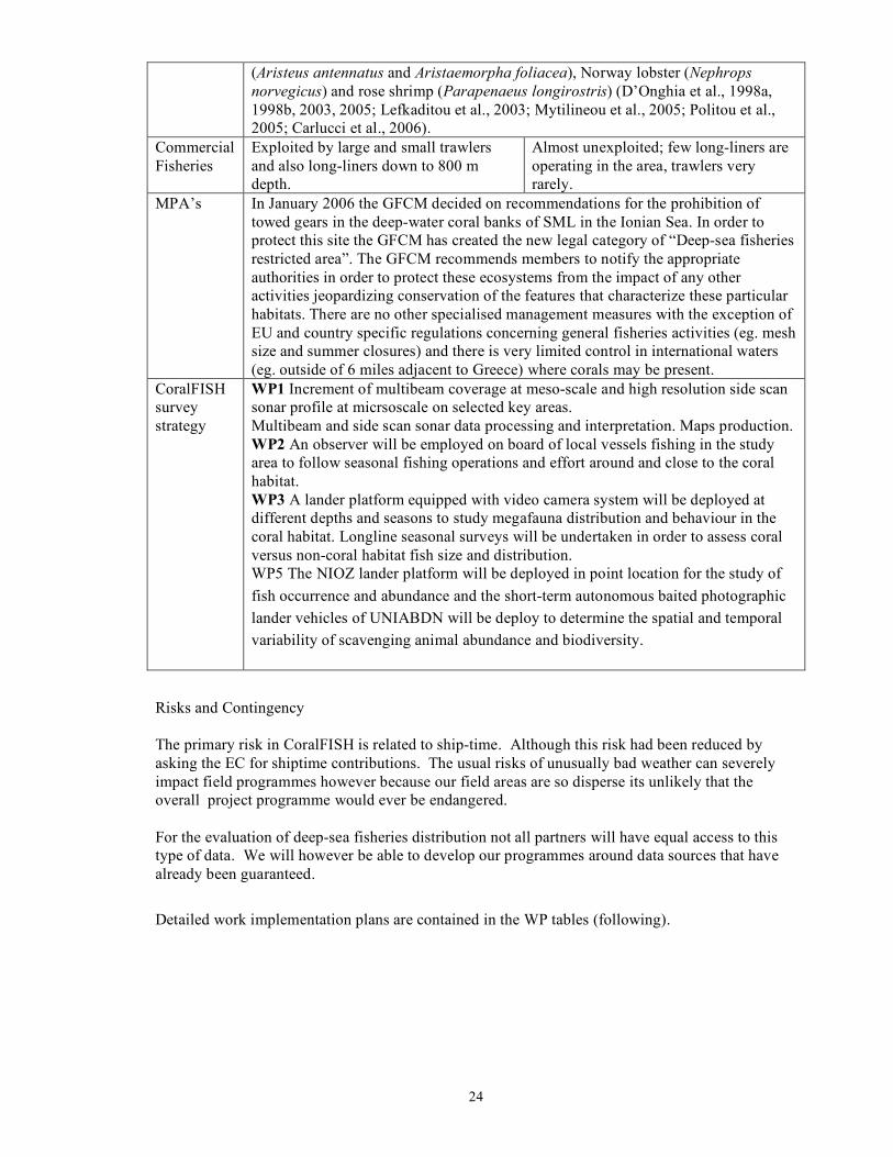
24
(Aristeus antennatus and Aristaemorpha foliacea), Norway lobster (Nephrops norvegicus) and rose shrimp (Parapenaeus longirostris) (D’Onghia et al., 1998a, 1998b, 2003, 2005; Lefkaditou et al., 2003; Mytilineou et al., 2005; Politou et al., 2005; Carlucci et al., 2006).
Commercial Fisheries
Exploited by large and small trawlers and also long-liners down to 800 m depth.
Almost unexploited; few long-liners are operating in the area, trawlers very rarely.
MPA’s In January 2006 the GFCM decided on recommendations for the prohibition of towed gears in the deep-water coral banks of SML in the Ionian Sea. In order to protect this site the GFCM has created the new legal category of “Deep-sea fisheries restricted area”. The GFCM recommends members to notify the appropriate authorities in order to protect these ecosystems from the impact of any other activities jeopardizing conservation of the features that characterize these particular habitats. There are no other specialised management measures with the exception of EU and country specific regulations concerning general fisheries activities (eg. mesh size and summer closures) and there is very limited control in international waters (eg. outside of 6 miles adjacent to Greece) where corals may be present.
CoralFISH survey strategy
WP1 Increment of multibeam coverage at meso-scale and high resolution side scan sonar profile at micrsoscale on selected key areas. Multibeam and side scan sonar data processing and interpretation. Maps production. WP2 An observer will be employed on board of local vessels fishing in the study area to follow seasonal fishing operations and effort around and close to the coral habitat. WP3 A lander platform equipped with video camera system will be deployed at different depths and seasons to study megafauna distribution and behaviour in the coral habitat. Longline seasonal surveys will be undertaken in order to assess coral versus non-coral habitat fish size and distribution. WP5 The NIOZ lander platform will be deployed in point location for the study of fish occurrence and abundance and the short-term autonomous baited photographic lander vehicles of UNIABDN will be deploy to determine the spatial and temporal variability of scavenging animal abundance and biodiversity.
Risks and Contingency The primary risk in CoralFISH is related to ship-time. Although this risk had been reduced by asking the EC for shiptime contributions. The usual risks of unusually bad weather can severely impact field programmes however because our field areas are so disperse its unlikely that the overall project programme would ever be endangered. For the evaluation of deep-sea fisheries distribution not all partners will have equal access to this type of data. We will however be able to develop our programmes around data sources that have already been guaranteed.
Detailed work implementation plans are contained in the WP tables (following).

25
Table 1.3 a: Work package list
Work package No
Work package title Type of activity
Lead participant No
Person-months
Start
month
End
month
1 Regional cold water coral settings
RTD 7 215.1 0 48
2 Regional deep-water fish and fisheries
RTD 4 118.3 0 48
3 Developing monitoring indicators: deep water fish occurrence and fisheries impacts
RTD 2 249.3 0 48
4 Developing monitoring indicators: genetic fingerprinting of cumulative long-term effects of fishing impacts on corals
RTD 4 52 0 48
5 Developing monitoring indicators: ecosystem function, modeling and metrics
RTD 8 97.5 13 48
6 Developing tools for ecosystem management: habitat suitability modelling
RTD 9 73.9 0 48
7 Developing tools for ecosystem management: identification of sensitive and essential/preferred fish habitat
RTD 15 64 0 48
8 Developing tools for ecosystem management: economic models and policy advice
RTD 10 49.5 0 48
9 Developing tools for ecosystem management: education, dissemination and outreach
RTD 11 40 0 48

26
10 Project coordination and data management
MGT 1 50 0 48
TOTAL 1000.6
Table 1.3a: Deliverables list
Del. no. Deliverable name WP no. Nature Diss
level Delivery date
D10.1 Project website for sharing of information between partners and to disseminate information to the wider community
10 1
D10.2 Project management handbook for regulations concerning data management, outputs 10 6
D10.4 Deliver six monthly progress, annual science and final report to the EC project office 10 6
D10.5 Design of the CoralFISH data archive 10 6
D3.1 Cruise protocols for standardised strategies and methodologies 3 6
D3.5 Strategic document and common protocols available to all relevant partners 3 6
D8.1
Report giving state of the art overview with regard to renewable and non-renewable habitat-fisheries interactions in bioeconomic modelling with different management regimes
8 6
D9.4 Distribution of a 6-monthly lay project newsletter 9 6
D1.1 Maps of CWC already documented occurrences within proper geomorphological chart 1 12
D10.3
Collate annual assessment and evaluation reports from all workpackages and present these for discussion at the annual Scientific Steering Committee meeting (M12)
10 12
D10.4 Deliver six monthly progress, annual science and final report to the EC project office 10 12
D10.6 Providing a data web site to all CoralFISH partners 10 12
D3.2 Annual assessment report by study area (M12 & M24), and final synthesis (M42) 3 12
D3.3 Post-cruise assessment report by study area (M12 & M24), and final synthesis (M42) 3 12
D3.4 Interim report on archived data (M12), and synthesis of new information (M42) 3 12
D7.1
A review of geostatistical approaches to integrated fisheries and habitat modelling with recommendations regarding best practice and approaches and how they can be optimised for application to the chose topical area
7 12
D9.1 Website with educational, public and scientific participant information sections 9 12
D9.3 Scientist placement with one school in each region 9 12
D10.4 Deliver six monthly progress, annual science and final report to the EC project office 10 18
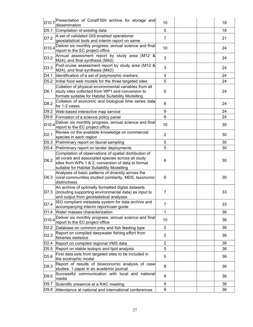
27
D10.7 Presentation of CoralFISH archive for storage and dissemination 10 18
D5.1 Compilation of existing data 5 18
D7.2 A set of validated GIS enabled operational geostatistical tools and interim report on same 7 21
D10.4 Deliver six monthly progress, annual science and final report to the EC project office 10 24
D3.2 Annual assessment report by study area (M12 & M24), and final synthesis (M42) 3 24
D3.3 Post-cruise assessment report by study area (M12 & M24), and final synthesis (M42) 3 24
D4.1 Identification of a set of polymorphic markers 4 24 D5.2 Initial food web models for the three targeted sites 5 24
D6.1 Collation of physical environmental variables from all study sites collected from WP1 and conversion to formats suitable for Habitat Suitability Modelling
6 24
D8.2 Collation of economic and biological time series data for 1-2 cases 8 24
D9.2 Web-based interactive map service 9 24 D9.6 Formation of a science policy panel 9 24
D10.4 Deliver six monthly progress, annual science and final report to the EC project office 10 30
D2.1 Review on the available knowledge on commercial species in each region 2 30
D5.3 Preliminary report on faunal sampling 5 30 D5.4 Preliminary report on lander deployments 5 30
D6.2
Compilation of observations of spatial distribution of all corals and associated species across all study sites from WPs 1 & 2, conversion of data to format suitable for Habitat Suitability Modelling
6 30
D6.3 Analyses of basic patterns of diversity across the coral communities studied (similarity, MDS, taxonomic distinctness
6 30
D7.3 An archive of optimally formatted digital datasets (including supporting environmental data) as input to and output from geostatistical analyses
7 33
D7.4 ISO compliant metadata system for data archive and accompanying interim report/user guide 7 33
D1.4 Water masses characterization 1 36
D10.4 Deliver six monthly progress, annual science and final report to the EC project office 10 36
D2.2 Database on common prey and fish feeding type 2 36
D2.3 Report on compiled deepwater fishing effort from fisheries statistics 2 36
D2.4 Report on compiled regional VMS data 2 36 D5.5 Report on stable isotopic and lipid analysis 5 36
D5.6 First data sets from targeted sites to be included in the ecotrophic model 5 36
D8.3 Report of results of bioeconomic analysis of case studies. 1 paper in an academic journal 8 36
D9.5 Successful communication with local and national media 9 36
D9.7 Scientific presence at a RAC meeting 9 36 D9.8 Attendance at national and international conferences 9 36
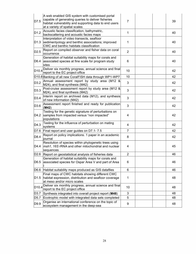
28
D7.5
A web enabled GIS system with customised portal capable of generating queries to deliver fisheries habitat vulnerability and supporting data to end users at a variety of spatial scales
7 39
D1.2 Acoustic facies classification, bathymetric, backscattering and acoustic facies maps 1 40
D1.3 Interpretation of video transects, seafloor sedimentyology and benthic associations; improved CWC and benthic habitats classification
1 40
D2.5 Report on compiled observer and fisher data on coral occurrence 2 40
D6.4 Generation of habitat suitability maps for corals and associated species at fine scale for program study sites
6 40
D10.4 Deliver six monthly progress, annual science and final report to the EC project office 10 42
D10.8 Banking of all new CoralFISH data through WP1-WP7 10 42
D3.2 Annual assessment report by study area (M12 & M24), and final synthesis (M42) 3 42
D3.3 Post-cruise assessment report by study area (M12 & M24), and final synthesis (M42) 3 42
D3.4 Interim report on archived data (M12), and synthesis of new information (M42) 3 42
D3.6 Assessment report finished and ready for publication (M42) 3 42
D4.2 Testing for the genetic signature of perturbations on samples from impacted versus “non impacted” populations
4 42
D4.3 Testing for the influence of perturbation on mating systems 4 42
D7.6 Final report and user guides on D7.1- 7.5 7 42
D8.4 Report on policy implications. 1 paper in an academic journal 8 42
D4.4 Resolution of species within phylogenetic trees using msh1, 16S rRNA and other mitochondrial and nuclear sequences
4 45
D2.6 Report on geostatistical analysis of fisheries data 2 46
D6.5 Generation of habitat suitability maps for corals and associated species for Ospar Area V and part of Area I
6 46
D6.6 Habitat suitability maps produced as GIS datafiles 6 46
D1.5 Final maps of CWC habitats showing different CWC habitat expression, distribution and seafloor coverage at meso and/or micro scales
1 48
D10.4 Deliver six monthly progress, annual science and final report to the EC project office 10 48
D3.7 Synthesis integrated into overall project report (M48) 3 48 D5.7 Ecotrophic model with integrated data sets completed 5 48
D9.9 Organise an international conference on the topic of ecosystem management in the deep-sea 9 48
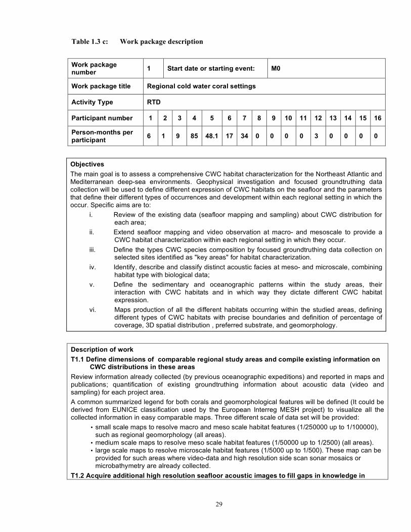
29
Table 1.3 c: Work package description
Work package number 1 Start date or starting event: M0
Work package title Regional cold water coral settings
Activity Type RTD
Participant number 1 2 3 4 5 6 7 8 9 10 11 12 13 14 15 16
Person-months per participant 6 1 9 85 48.1 17 34 0 0 0 0 3 0 0 0 0
Objectives The main goal is to assess a comprehensive CWC habitat characterization for the Northeast Atlantic and Mediterranean deep-sea environments. Geophysical investigation and focused groundtruthing data collection will be used to define different expression of CWC habitats on the seafloor and the parameters that define their different types of occurrences and development within each regional setting in which the occur. Specific aims are to:
i. Review of the existing data (seafloor mapping and sampling) about CWC distribution for each area;
ii. Extend seafloor mapping and video observation at macro- and mesoscale to provide a CWC habitat characterization within each regional setting in which they occur.
iii. Define the types CWC species composition by focused groundtruthing data collection on selected sites identified as "key areas" for habitat characterization.
iv. Identify, describe and classify distinct acoustic facies at meso- and microscale, combining habitat type with biological data;
v. Define the sedimentary and oceanographic patterns within the study areas, their interaction with CWC habitats and in which way they dictate different CWC habitat expression.
vi. Maps production of all the different habitats occurring within the studied areas, defining different types of CWC habitats with precise boundaries and definition of percentage of coverage, 3D spatial distribution , preferred substrate, and geomorphology.
Description of work T1.1 Define dimensions of comparable regional study areas and compile existing information on
CWC distributions in these areas Review information already collected (by previous oceanographic expeditions) and reported in maps and publications; quantification of existing groundtruthing information about acoustic data (video and sampling) for each project area. A common summarized legend for both corals and geomorphological features will be defined (It could be derived from EUNICE classification used by the European Interreg MESH project) to visualize all the collected information in easy comparable maps. Three different scale of data set will be provided:
• small scale maps to resolve macro and meso scale habitat features (1/250000 up to 1/100000), such as regional geomorphology (all areas).
• medium scale maps to resolve meso scale habitat features (1/50000 up to 1/2500) (all areas). • large scale maps to resolve microscale habitat features (1/5000 up to 1/500). These map can be
provided for such areas where video-data and high resolution side scan sonar mosaics or microbathymetry are already collected.
T1.2 Acquire additional high resolution seafloor acoustic images to fill gaps in knowledge in

30
regional study areas New seafloor mapping at meso- and micro- scales covering all the area where CWC occurrences have been documented, using multibeam echo sounder (bathymetry and backscattering), high frequency side-scan sonar (to acquire high quality backscatter images of the seafloor in selected areas) and Subbottom profiler. Video data performed by the manned submersible or the video footage acquired by a remotely-operated vehicle (ROV) operating in point locations for each area The bathymetry and backscatter data will be processed with the resulting bathymetry models and backscatter mosaics interpreted according to schemes of geological and biological habitat description. This task will fill gaps identified from Task 1.1, allowing a comprehensive characterization of the different geomorphologic units identified from the previous output for each area. Detailed maps of CWC distribution with precise boundaries and percentage of coverage, 3D spatial distribution, preferred substrate, and geomorphology will be produced. T1.3 Produce a classification of the different types of coral habitat in each regional study area This task will be performed by: The study of existing and newly acquired video data (for each area) to precisely define species habitat composition. Acquisition of detailed and focused ground truthing data (collected by sampling - corer, interface corer, grab) for micro-scale data interpretation, acoustic facies calibration and habitat characterization. Based on existing and new data, new information will be provided on: types of CWC occurrences, CWC species composition, resulting morphologies within the different geomorphologic units where they occur, sedimentary, benthic and oceanographic patterns. T1.4 Characterise near bottom water masses in each regional study area The study of existing data or the deployment of different oceanographic stations to characterize near-bottom variations of water temperature, salinity, level of light, current speed, throughout a yearly cycle T1.5 Quantify the importance by area of coral habitat to the total in each regional study area The identification of the sedimentological, biological and oceanographic interaction with CWC habitats and their resulting morphological expression, along with in situ observations and measurements, will be instrumental to developing our understanding of the variability of conditions cold-water coral assemblages are associated with. This data will help determine how sensitive these species may be to environmental changes. The observations will allow definition of the environmental parameters (substrate, geomorphology, bottom currents interactions) whose variability allow different CWC habitat expression.
Deliverables D1.1 Maps of CWC already documented occurrences within proper geomorphological chart (M12) D1.2 Acoustic facies classification, bathymetric, backscattering and acoustic facies maps (M40) D1.3 Interpretation of video transects, seafloor sedimentology and benthic associations; improved CWC and benthic habitats classification (M30) D1.4 Water masses characterization (M36) D1.5 Final maps of CWC habitats showing different CWC habitat expression, distribution and seafloor coverage at meso and/or micro scales (M48)
Milestones Complete the draft CWC legend & the review at the 3 scales (M9) Oceanographic cruise planning; completion of acoustic and video cruises; processing of the bathymetric and backscattering data (M40) Complete the sampling cruises and processing of the samples (M40) Complete the processing of benthic station data (M33) Complete the improved CWC legend and CWC habitat maps (M45)

31
Work package number 2 Start date or starting event: M0
Work package title Regional deep-water fish and fisheries review
Activity Type RTD
Participant number 1 2 3 4 5 6 7 8 9 10 11 12 13 14 15 16
Person-months per participant 5 10.5 11 12 50.8 5 12 0 0 0 3 0 1 0 0 0
Objectives
The overall objectives of the workpackage are to: i. Identify which commercial species are utilising reefs and to what extent fish interact with
coral habitats in the different regions. ii. Evaluate the distribution of deepwater bottom fishing effort in relation to coral habitats.
Description of work Information on deepwater fish and fishing effort will be compiled from existing data and new observations. The participants will undertake the tasks in consideration of data availability in each region. T2.1 Review the available knowledge on the distribution and ecology of commercial fish in each
regional study area This task will identify and compile information on commercial fish occurrence, distribution, ecology and behaviour in the regional coral reefs areas from a) previous studies (reports, papers, video material) and b) new information collected from ROV observations during WP1. T2.2 Build a database of existing and new commercial fish gut content analyses, identify the most
common prey by fish species and characterise their general feeding type Existing data to be identified and compiled concerning stomach content analysis of reef utilising commercial species. Data to be reinforced with any new information from commercial species fished from the reefs during WP3. Most common prey to be identified by fish species and fish species to be characterised by diet. Data to be entered into common format for use in model parameterisation in WP5. T2.3 Compile data on deepwater fishing effort in the NE Atlantic and Ionian Sea Fishery effort statistics, based on logbook data, will be used to compile an estimate of international fishing effort per ICES rectangle, fishing gear and year. ICES rectangles included in the database will be restricted to those where both CWC and bottom fishing may occur. Where fishery statistics are available at a finer resolution than ICES rectangles (e.g. Iceland), this resolution will be used. T2.4 Compile VMS data on fishing activity in regional study areas VMS data to be compiled for the study regions. This may provide a higher resolution assessment of effort. The geographical resolution of the analysis will be defined in relation to WP1. Technically a resolution of 100 n.m² is possible. Higher resolution may be used for some of the study sites and in these smaller locations the finest possible resolution according to data accuracy will be explored. T2.5 Compile observer and fisher data on coral occurrence Data from the observers program will be use to produce an alternative estimation of the distribution of fishing effort. This data will provide exact locations of the fishing operations and will allow the assessment of whether fishing gears are deployed on reefs and sensitive beds or on neighbouring sedimentary bottoms. Additional on-board observations will be undertaken in Iceland, the Northern Ionian Sea and the Azores, to collect data on the coral by-catch. In the Eastern Ionian Sea, a questionnaire will be carried out to assess the geographical distribution of fishing and interactions with CWC. T2.6 Review and apply geo-statistical analysis approaches to fisheries data Geostatistical models will be used to assess the relationships between fishing, fish and habitats by analytical comparison (autocorrelation) of the spatial distributions of commercial fish species, coral
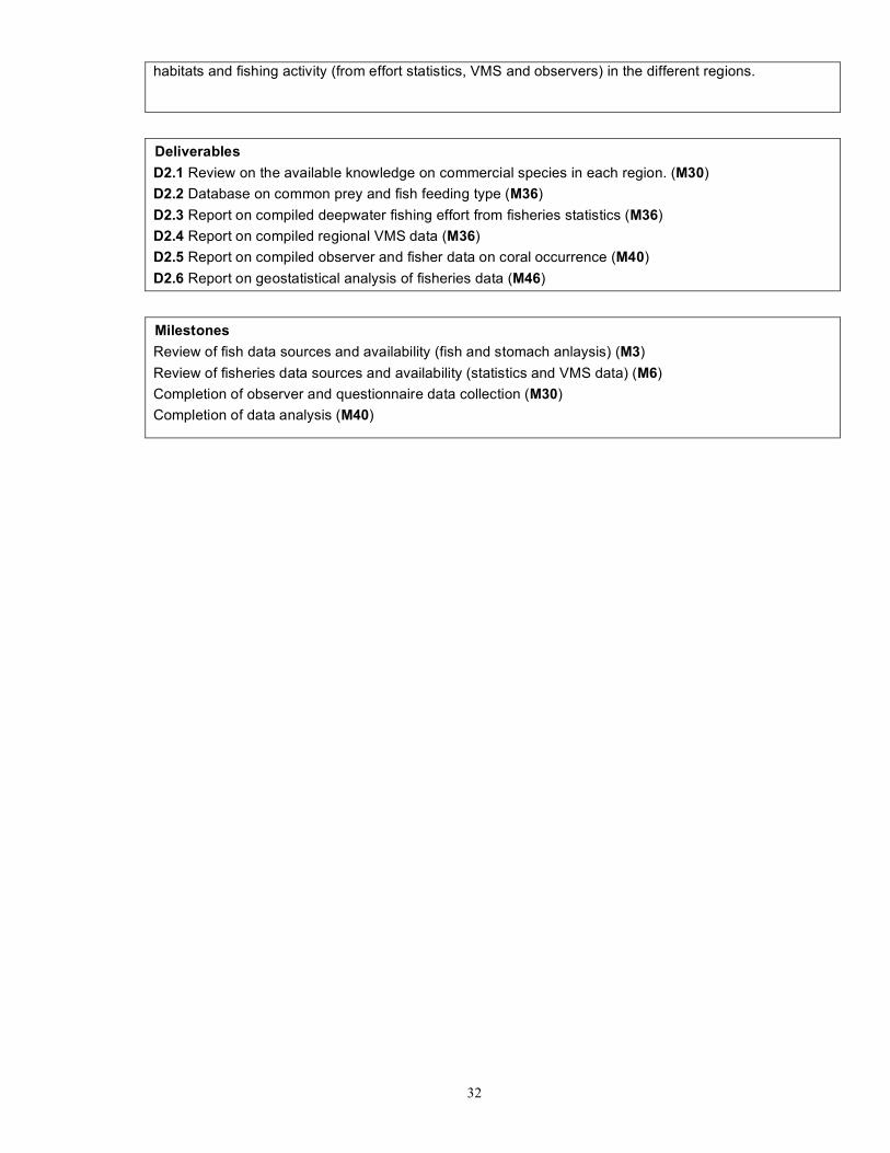
32
habitats and fishing activity (from effort statistics, VMS and observers) in the different regions.
Deliverables D2.1 Review on the available knowledge on commercial species in each region. (M30) D2.2 Database on common prey and fish feeding type (M36) D2.3 Report on compiled deepwater fishing effort from fisheries statistics (M36) D2.4 Report on compiled regional VMS data (M36) D2.5 Report on compiled observer and fisher data on coral occurrence (M40) D2.6 Report on geostatistical analysis of fisheries data (M46)
Milestones Review of fish data sources and availability (fish and stomach anlaysis) (M3) Review of fisheries data sources and availability (statistics and VMS data) (M6) Completion of observer and questionnaire data collection (M30) Completion of data analysis (M40)
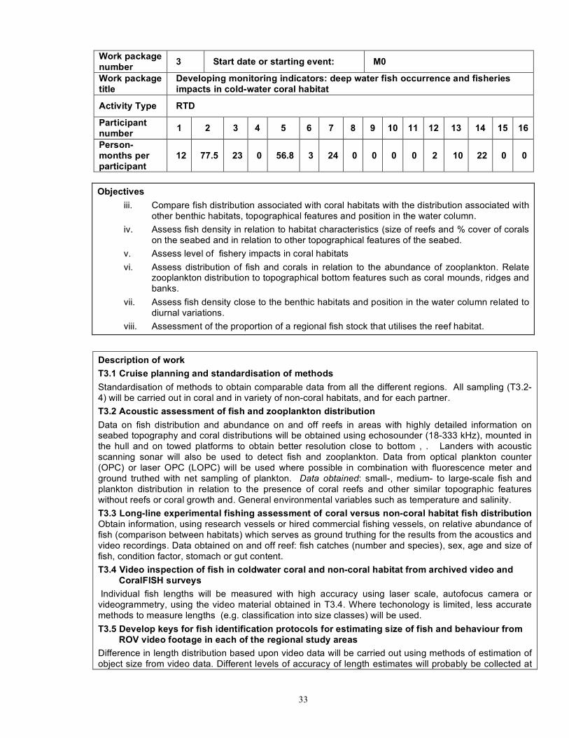
33
Work package number 3 Start date or starting event: M0
Work package title
Developing monitoring indicators: deep water fish occurrence and fisheries impacts in cold-water coral habitat
Activity Type RTD
Participant number 1 2 3 4 5 6 7 8 9 10 11 12 13 14 15 16
Person-months per participant
12 77.5 23 0 56.8 3 24 0 0 0 0 2 10 22 0 0
Objectives
iii. Compare fish distribution associated with coral habitats with the distribution associated with other benthic habitats, topographical features and position in the water column.
iv. Assess fish density in relation to habitat characteristics (size of reefs and % cover of corals on the seabed and in relation to other topographical features of the seabed.
v. Assess level of fishery impacts in coral habitats vi. Assess distribution of fish and corals in relation to the abundance of zooplankton. Relate
zooplankton distribution to topographical bottom features such as coral mounds, ridges and banks.
vii. Assess fish density close to the benthic habitats and position in the water column related to diurnal variations.
viii. Assessment of the proportion of a regional fish stock that utilises the reef habitat.
Description of work T3.1 Cruise planning and standardisation of methods Standardisation of methods to obtain comparable data from all the different regions. All sampling (T3.2-4) will be carried out in coral and in variety of non-coral habitats, and for each partner. T3.2 Acoustic assessment of fish and zooplankton distribution Data on fish distribution and abundance on and off reefs in areas with highly detailed information on seabed topography and coral distributions will be obtained using echosounder (18-333 kHz), mounted in the hull and on towed platforms to obtain better resolution close to bottom , . Landers with acoustic scanning sonar will also be used to detect fish and zooplankton. Data from optical plankton counter (OPC) or laser OPC (LOPC) will be used where possible in combination with fluorescence meter and ground truthed with net sampling of plankton. Data obtained: small-, medium- to large-scale fish and plankton distribution in relation to the presence of coral reefs and other similar topographic features without reefs or coral growth and. General environmental variables such as temperature and salinity. T3.3 Long-line experimental fishing assessment of coral versus non-coral habitat fish distribution Obtain information, using research vessels or hired commercial fishing vessels, on relative abundance of fish (comparison between habitats) which serves as ground truthing for the results from the acoustics and video recordings. Data obtained on and off reef: fish catches (number and species), sex, age and size of fish, condition factor, stomach or gut content. T3.4 Video inspection of fish in coldwater coral and non-coral habitat from archived video and
CoralFISH surveys Individual fish lengths will be measured with high accuracy using laser scale, autofocus camera or videogrammetry, using the video material obtained in T3.4. Where techonology is limited, less accurate methods to measure lengths (e.g. classification into size classes) will be used. T3.5 Develop keys for fish identification protocols for estimating size of fish and behaviour from
ROV video footage in each of the regional study areas Difference in length distribution based upon video data will be carried out using methods of estimation of object size from video data. Different levels of accuracy of length estimates will probably be collected at

34
the different study areas. Fine accuracy of individual length required dedicated devices such as laser scale, autofocus camera or videogrammetry. If such devices are not available to all surveys, less precise length data such as will be derived from robust length estimates (e.g. categorisation of individuals as large adults, medium size and small juveniles). T3.6 Estimate levels of fishing impact from ROV video transects At the scale of study sites, ROV transects will be used to assess the proportion of CWC (and other benthic communities) that have been impacted by fishing. This includes:
• the proportion of the surveyed area that has been (severely, moderately or not) impacted by towed gears ;
• the density of lost fishing gears ; • investigate the relative effect of passive (long-lines and nets) and towed gears on CWC and
other benthic communities. These data will be compared with archive data from submersibles and ROVs where available. T3.7 Synthesise all new fish/habitat data and relate to wider scale of regional study Patterns of distribution and abundance on a wider spatial scale will be analysed, i.e. in areas of sizes more relevant to regional fish stock assessments and fisheries management. This analysis will be based on the habitat-specific observations of fish density and abundance derived in Task 2-4, and a thorough mapping of the habitats in wider areas, e.g. ICES Statistical Rectangles or larger. Estimates of habitat-specific densities of fish derived from scientific sampling described above will be scaled up to estimates for the wider area by using high-resolution regional habitat maps from which sizes of different habitats can be calculated. The key underlying assumption is that the detailed sampling on and off local coral areas results in representative density estimates that can be used to derive regional assessments. Analysis of high resolution (1 x 1 nm) fishery catch data (logbook data from 1991 onwards) for both otter-trawl and long-line and data from stock-assessment surveys (otter-trawl; 1985 onwards) will be analysed to examine the level of association in distribution patterns of fish and cold-water corals. GIS methods will be used to compare the spatial and temporal distribution patterns in fish population parameters (e.g. abundance, age-at-size etc.) in and out of coral habitats. In addition, spatial and temporal distribution patterns of other environmental data (e.g. bathymetry, bottom type, temperature) will be analysed to assess the relative importance of these relative to the habitat itself in structuring fish communities.
Deliverables D3.1 Cruise protocols for standardised strategies and methodologies (M6) D3.2 Annual assessment report by study area (M12 & 24), and final synthesis (M42) D3.3 Post-cruise assessment report by study area (M12 & 24), and final synthesis (M42) D3.4 Interim report on archived data (M12), and synthesis of new information (M42) D3.5 Strategic document and common protocols available to all relevant partners (M6) D3.6 Assessment report finished and ready for publication (M42) D3.7 Synthesis integrated into overall project report (M48)
Milestones Corresponding cruise plans for all study areas (M3) Estimates of abundance and descriptions of identity and distributions of sound-scattering animals (M39) Estimates of abundance and descriptions of identity and distributions of fish caught on commercial long lines (M9, 21 & 39) Visual census and descriptions of identity and distributions of fish associated with coral for archived data (M9) and new data (M39) Common keys and protocols for present and future studies (M3) Documented assessment of human impacts based on comprehensive and standardised visual census (M39)

35
Improved and up-to-date synthesis of knowledge and state (M45)

36
Work package number 4 Start date or starting event: M0
Work package title Developing monitoring indicators : genetic fingerprinting of cumulative long-term effects of fishing impacts on corals
Activity Type RTD
Participant number 1 2 3 4 5 6 7 8 9 10 11 12 13 14 15 16
Person-months per participant 0 0 0 29 0 0 0 0 23 0 0 0 0 0 0 0
Objectives i. To use molecular tools to test for the occurrence of genetic erosion or bottleneck traces in
coral populations from impacted versus non impacted areas. ii. To investigate the influence of impacts on the reproductive mode (clonality, random
mating), that would be susceptible to affect the potential species in the long term. iii. To investigate population genetics of some species of corals in order to describe dispersal
patterns and to compare the connectivity of the system for the different species. iv. To use molecular phylogenetic approaches to assist the identification of coral species and
to study global patterns of evolution in deep-sea corals.
Description of work T4.1 Build and screen coral microsatellites Microsatellites libraries will be built for a set of corallian species distributed widely, in order to screen for polymorphic markers. Selection of markers will be based on two criteria:
• markers will have to be polymorphic, codominant, and respect the pattern expect under Mendelian inheritance;
• the set of several markers retained will have to be discriminant enough to allow the identification of clonemate on the basis of their multilocus genotype.
T4.2 Genotype natural populations sampled All samples collected will be genotyped with the markers developed, and the following parameters will be estimated:
• Clonal diversity (i.e. number of distinct multilocus genotypes compared to the number of samples analysed)
• Allelic richness within samples • Test for possible departure from Hardy Weinberg and linkage disequilibrium • Estimates of genetic structure, in order to estimate the dispersal scale for species, to make
inferences on the possible level of connection by gene flow of the different areas along the distribution range.
T4.3 Determine degree of genetic erosion in impacted versus non-impacted areas This will be done by comparing, among impacted versus non impacted sites :
• The clonal diversity (as an indirect measure of clonal versus sexual investment) • The indices of recent reduction of population size (i.e. bottleneck tests) • The allelic richness (as an indirect estimate of their potential for future adaptive changes)
T4.4 Bar code all coral species sampled All species sampled in the course of the project will be replaced in the Tree Of Life using nuclear and mitochondrial genes. Molecular phylogenetic analyses of corals for evolutionary studies will be performed using the same genes.
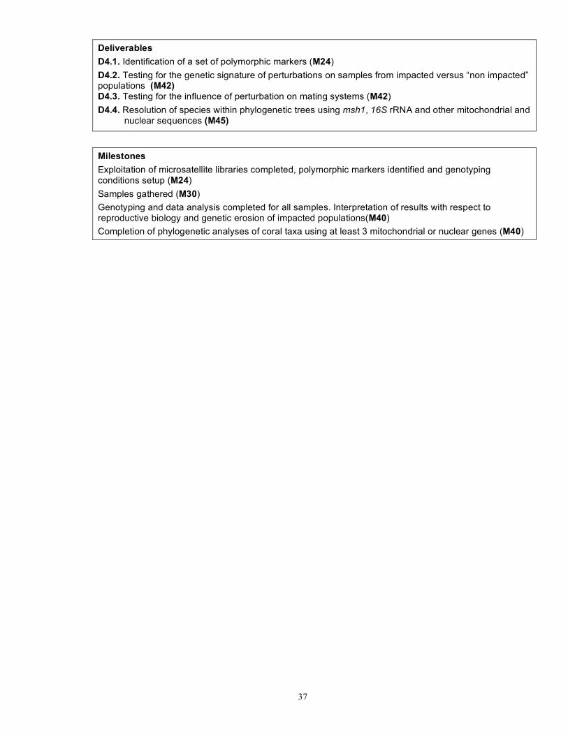
37
Deliverables D4.1. Identification of a set of polymorphic markers (M24) D4.2. Testing for the genetic signature of perturbations on samples from impacted versus “non impacted” populations (M42) D4.3. Testing for the influence of perturbation on mating systems (M42) D4.4. Resolution of species within phylogenetic trees using msh1, 16S rRNA and other mitochondrial and
nuclear sequences (M45)
Milestones Exploitation of microsatellite libraries completed, polymorphic markers identified and genotyping conditions setup (M24) Samples gathered (M30) Genotyping and data analysis completed for all samples. Interpretation of results with respect to reproductive biology and genetic erosion of impacted populations(M40) Completion of phylogenetic analyses of coral taxa using at least 3 mitochondrial or nuclear genes (M40)

38
Work package number 5 Start date or starting event: M12
Work package title Developing monitoring indicators: ecosystem function, modelling and metrics
Activity Type RTD
Participant number 1 2 3 4 5 6 7 8 9 10 11 12 13 14 15 16
Person-months per participant 0 5 0 0 0 16 0 24 0 0 33 36 0 0 0 0
Objectives To elucidate and model the energy transfers that exist between external food sources (algae, detritus, zooplankton), via the organisms inhabiting coral systems, from macrobenthos to larger megabenthos, and up to the fish for three reference sites: the Loften area (Norway), Rockall Trough (Ireland) and the Ionian Sea (Mediterranean).
Description of work T5.1 Build a comprehensive database of existing food web modelling useful data Existing data, from the HERMES project, together with literature information on coral systems will be compiled in a comprehensive data base. In addition to site-specific information, data not directly gathered at the focus sites will be used to derive relationships between quantities (e.g. respiration – size relationships). T5.2 Develop initial food web models for three contrasting regions After identifying the required complexity of the models, in close cooperation with the other partners, a set of preliminary models for the coral ecosystems will be set up, one for each of the three detailed sites. The models to be developed will be steady-state mass balance models, which allow reconstructing plausible food webs and their uncertainty, based on a limited data set. T5.3 Estimate standing stocks of main faunal compartments Undisturbed macrofauna samples will be collected quantitatively with a boxcorer at the three representative sites to estimate the density and biomass of the coral community. The density and biomass of the benthic megafauna (including fish) will be assessed from videotracks over the coral reefs, and if necessary compared with a nearby non-coral area, where ground-truthing with a quantitatively trawl is ethically and logically justified. Scavengers will be caught with baited traps. Faunal density and biomass will be measured using the classic methods. These data, together with the stable isotopic and lipid composition, will form the basis of the newly developed site-specific mathematical models, describing the flow of organic matter to the trophic food web. T5.4 Carry out lander deployments and rate measurements in three contrasting regions A fully equipped NIOZ lander (current meter, sediment trap, optical back scatter, fluorimeter, baited time-lapse video camera, scanning sonar system) will be used to measure in situ sediment mass fluxes, current direction and velocities, turbidity, temperature and fluorescence. At least 3 deployments of several days will be carried out at the 3 target sites. At Rockall Trough also seasonal information will be collected by a long-term deployment (months). On-board deck incubations of selected taxa and dead and living coral will provide estimates of oxygen consumption rates. T5.5 Measure stable isotope and lipids for major faunal compartments and potential food sources The stable isotope signatures of selected tissues of the major macro- and megafaunal components will be analyzed using Isotope Ratio Mass Spectrometry (13C, 15N) at all sites. Gas chromatography will be used to quantify and characterize lipids of selected taxa. The potential food sources (suspended particles, zooplankton and algae) will also be analyzed for their stable isotopes and lipid composition. Zooplankton will be caught with a plankton net; suspended matter will be sampled with SAPS.

39
T5.6 Synthesise modelling relevant fish data The linkage of the coral food webs with fishes will make use of data collated in workpackages 2 and 3. Diet specification based on gut contents, biomasses of the main fish groups, stable isotopic composition of fish tissue, visual observations (preys, fish preferred habitat) will be used as input to the model. T5.7 Finalise food-web models for three contrasting regions For each contrasting region, a mass balance model describing the flow of external food sources through the entire food web and up to fish will be made.
Deliverables D5.1 Compilation of existing data (M18) D5.2 Initial food web models for the three targeted sites (M24) D5.3 Preliminary report on faunal sampling (M30) D5.4 Preliminary report on lander deployments (M30) D5.5 Report on stable isotopic and lipid analysis (M36) D5.6 First data sets from targeted sites to be included in the ecotrophic model (M36) D5.7 Ecotrophic model with integrated data sets completed (M48)
Milestones Catalogue of available data (M18) First implemented ecotrophic models for three targeted sites (M24) Preliminary report on newly acquired faunal data at three targeted sites (M30) Preliminary report on lander deployments at three targeted sites (M30) Report on stable isotopic and lipid analysis (M36) New data set at three sites implemented in ecotrophic model (M42) Ecotrophic model completed (M48)

40
Work package number 6 Start date or starting event: M0
Work package title Developing tools for ecosystem management : habitat suitability modelling
Activity Type RTD
Participant number 1 2 3 4 5 6 7 8 9 10 11 12 13 14 15 16
Person-months per participant 24 0 3 0 24.9 0 0 0 22 0 0 0 0 0 0 0
Objectives To identify suitable habitat for cold-water coral species based on observations of environmental and morphological parameters and comparison of these to coral occurrences.
Description of work Task 6.1 – Collate environmental and hydrographic data at the OSPAR Region V scale and local
scale for project study areas Physical data, including bathymetry, substrate type and slope will be acquired from multibeam and side-scan data and in situ measurements (surface primary productivity, temperature and bottom current speed, seawater chemistry) where cold-water coral species are present or absent along with data on substrata and on evidence of fishing disturbance. Slope will be calculated from the bathymetry data, using ARCView software. Substrata will be categorized into classes based on the Lidden-Wentworth size classification for sediment grains. Oceanographic stations (AQUADOPP) will be deployed in situ within coral assemblages to measure bottom temperature, salinity, turbidity and current speed, throughout a yearly cycle. Long-term oceanographic data will also be extracted from datasets available. Task 6.2 – Biological data Data on the spatial distribution of corals and associated species will be assembled from across the project in a format suitable for use in Primer-E and Biomapper. Task 6.3 – Community diversity Basic patterns of the distribution of species within the communities targeted by this project will be undertaken using the statistical package PRIMER-E. Data arising from the present study will be used to generate a distance matrix will of between-site similarities based on data for all species and sites, employing the Bray-Curtis similarity coefficient. This distance matrix will be used to produce an ordination plot of between-site similarities using non-metric multidimensional scaling (n-MDS). To further characterise the biodiversity at the different sites we will calculate values of average taxonomic distinctness, D+ ('taxonomic breadth') and variation in taxonomic distinctness L+. We will then test whether values deviate from the expected values for an assemblage of known species richness drawn from the same regional fauna, using TAXDTEST. Task 6.4 – Habitat Suitability Modelling Habitat suitability modelling will be undertaken using two main approaches
• (i) Non-spatial statistical quantification of species-environment relationships • (ii) spatially explicit statistical modelling of species distribution.
For (i) the programme Canonical Community Ordination (CANOCO) will be used to relate species distribution and community structure to environmental variables measured. Moreover, relationships between environmental variables and multivariate community structure will be assessed using the BIO-ENV procedure within the PRIMER software. In this procedure rank correlations between a similarity matrix derived from the biotic data and matrices derived from various subsets of environmental data will be calculated. For (ii) statistical techniques will be used to generate habitat suitability maps using the modelling program

41
BioMapper. This is because most data available for coral distributions to date is presence data. Modelling will be undertaken at two scales (i) coarse resolution for regional scale analyses focusing on the influences of physical environmental parameters (limiting factors) on distribution, and (ii) fine-scale analyses, focusing on the influence of patchily distributed resources, such as elevated microtopography, in the Azores, Iceland and Mediterranean study sites. Data from species location, environmental and morphological parameters will be imported into the modelling program as a raster-based grid file. Marginality and specialization values will be used to identify the environmental parameters with the greatest influence (weight) on the distribution of each cold-water coral species. Depending on the data collected on this program, other methods for modelling habitat suitability will be. Task 6.5 –Develop habitat suitability maps for cold-water coral occurrence at the OSPAR Region
V and part of Region I (Iceland) scale Habitat suitability maps will be generated for OSPAR Region V and part of Region I using data arising from this project, existing datasets and data arising from other European or national programmes. Task 6.6 – Produce predicted cold-water coral distributions on maps as a GIS layer The habitat suitability maps and environmental data & species observations will be imported into GIS.
Deliverables D6.1 Collation of physical environmental variables from all study sites collected from WP1 and
conversion to formats suitable for Habitat Suitability Modelling (M24) D6.2 Compilation of observations of spatial distribution of all corals and associated species across all
study sites from WPs 1 & 2, conversion of data to format suitable for Habitat Suitability Modelling (M30)
D6.3 Analyses of basic patterns of diversity across the coral communities studied (similarity, MDS, taxonomic distinctness (M30)
D6.4 Generation of habitat suitability maps for corals and associated species at fine scale for program study sites (M40).
D6.5 Generation of habitat suitability maps for corals and associated species for Ospar Area V and part of Area I (M46).
D6.6 Habitat suitability maps produced as GIS datafiles (M46).
Milestones Final identification and collation of all available environmental datasets and of the environmental data collected by the project (M24) Identification of species and groups of species for which sufficient data has been collected / compiled for habitat suitability modelling (M30) Completion of basic diversity analyses, comparison with other studies, identification of further data requirements (M36) Production of habitat suitability maps for program study areas for corals and associated species identified in M6.2 (M40) Production of habitat suitability maps for OSPAR Area V and part of Area I for corals and associated species identified in M6.2 (M46) Provision of GIS-format data on physical parameters, species distribution and habitat suitability for GIS WP7 (M46).

42
Work package number 7 Start date or starting event: M0
Work package title Developing tools for ecosystem management: identification sensitive and essential/preferred fish habitat
Activity Type RTD
Participant number 1 2 3 4 5 6 7 8 9 10 11 12 13 14 15 16
Person-months per participant 11 2 0 0 0 0 1 0 0 0 0 0 0 0 49 0
Objectives ix. To identify, develop, optimise and apply integrated geostatistical and techniques within a
GIS framework as tools to facilitate ecosystem management x. To apply these tools to facilitate identification of essential and preferred fish habitats with
reference to cold water coral bioherms xi. To enable production and web dissemination of vulnerability atlases with utility at various
end user scales
Description of work T7.1 Review available geostatistical approaches to integrated fisheries and habitat modelling Undertake a comprehensive review of literature and ongoing pioneer research, and undertake pilot testing to confirm state of the art and practical/operational viability of geostatistical techniques for modelling and integrating fisheries and habitats data. T7.2 Integrate all relevant geostatistical protocols, habitat, fish and fisheries information, in GIS
model. Data acquisition (via Pangaea link) and incorporation of sample data into data models and software applications. Development and operational testing of options and techniques for statistical/spatial analysis. Prioritisation of approach to be adopted. Systematic application of selected methodology to comprehensive range of datasets; development and application of batch processing tools. Systematic archiving (locally and centrally via Pangaea) and cataloguing (ISO compliant metadata) of derived datasets and datalayers. T7.3 Optimise web GIS engine Customise and optimise web GIS operating framework and interfaces to facilitate intuitive enduser assess and optimal functionality. To be accomplished in compliance with state of the art standards (e.g. ISO 19115 and 19139 metadata standards) and technologies (e.g. OGC compliant web mapping technologies) for data handling. T7.4 Formulate processes and queries to produce a CoralFISH atlas at OSPAR Area V scale and
regional study area scale highlighting i) areas of vulnerable habitat and ii) essential fish habitat
Develop web compatible software applications/advanced queries and associated user-friendly protocols that enable scientific end-users to access/compile layers depicting (vulnerable/essential fish habitat). Through options testing this task will also scope the architecture, protocols and functionality required to enable end-users to create their own such layers in the future (e.g. for areas where existing requisite datasets may be sparse or lacking).
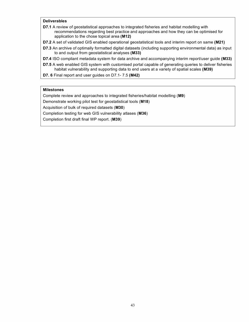
43
Deliverables D7.1 A review of geostatistical approaches to integrated fisheries and habitat modelling with
recommendations regarding best practice and approaches and how they can be optimised for application to the chose topical area (M12)
D7.2 A set of validated GIS enabled operational geostatistical tools and interim report on same (M21) D7.3 An archive of optimally formatted digital datasets (including supporting environmental data) as input
to and output from geostatistical analyses (M33) D7.4 ISO compliant metadata system for data archive and accompanying interim report/user guide (M33) D7.5 A web enabled GIS system with customised portal capable of generating queries to deliver fisheries
habitat vulnerability and supporting data to end users at a variety of spatial scales (M39) D7. 6 Final report and user guides on D7.1- 7.5 (M42)
Milestones Complete review and approaches to integrated fisheries/habitat modelling (M9) Demonstrate working pilot test for geostatistical tools (M18) Acquisition of bulk of required datasets (M30) Completion testing for web GIS vulnerability atlases (M36) Completion first draft final WP report. (M39)
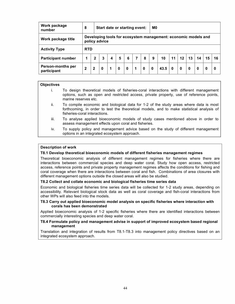
44
Work package number 8 Start date or starting event: M0
Work package title Developing tools for ecosystem management: economic models and policy advice
Activity Type RTD
Participant number 1 2 3 4 5 6 7 8 9 10 11 12 13 14 15 16
Person-months per participant 2 2 0 1 0 0 1 0 0 43.5 0 0 0 0 0 0
Objectives i. To design theoretical models of fisheries-coral interactions with different management
options, such as open and restricted access, private property, use of reference points, marine reserves etc.
ii. To compile economic and biological data for 1-2 of the study areas where data is most forthcoming, in order to test the theoretical models, and to make statistical analysis of fisheries-coral interactions.
iii. To analyse applied bioeconomic models of study cases mentioned above in order to assess management effects upon coral and fisheries.
iv. To supply policy and management advice based on the study of different management options in an integrated ecosystem approach.
Description of work T8.1 Develop theoretical bioeconomic models of different fisheries management regimes Theoretical bioeconomic analysis of different management regimes for fisheries where there are interactions between commercial species and deep water coral. Study how open access, restricted access, reference points and private property management regimes affects the conditions for fishing and coral coverage when there are interactions between coral and fish. Combinations of area closures with different management options outside the closed areas will also be studied. T8.2 Collect and collate economic and biological fisheries time series data Economic and biological fisheries time series data will be collected for 1-2 study areas, depending on accessibility. Relevant biological stock data as well as coral coverage and fish-coral interactions from other WPs will also feed into the models. T8.3 Carry out applied bioeconomic model analysis on specific fisheries where interaction with
corals has been demonstrated Applied bioeconomic analysis of 1-2 specific fisheries where there are identified interactions between commercially interesting species and deep water coral. T8.4 Formulate policy and management advise in support of improved ecosystem based regional
management Translation and integration of results from T8.1-T8.3 into management policy directives based on an integrated ecosystem approach.

45
Deliverables D8.1 Report giving state of the art overview with regard to renewable and non-renewable habitat-fisheries
interactions in bioeconomic modelling with different management regimes. (M6) D8.2 Collation of economic and biological time series data for 1-2 cases. (M24) D8.3 Report of results of bioeconomic analysis of case studies. 1 paper in an academic journal. (M36) D8.4 Report on policy implications. 1 paper in an academic journal. (M42)
Milestones State of the art overview report of renewable and non-renewable habitat-fisheries interactions in bioeconomic modelling. (M3) Collation of data and current knowledge of coral-fisheries interaction. Interim database finalised (M21) Theoretical and applied bioeconomic modelling papers on different management options and coral-fisheries interactions. (M33) Report on policy development. Paper on applied bioeconomic models of coral-fisheries interactions (M39)

46
Work package number 9 Start date or starting event: M0
Work package title Developing tools for ecosystem management: education, dissemination and outreach
Activity Type Public outreach and dissemination
Participant number 1 2 3 4 5 6 7 8 9 10 11 12 13 14 15 16
Person-months per participant 18 3 1 0 1.5 0 2 2 1.5 0 8 0.5 0 1 0 0
Objectives i. Development of a lay website with educational, public and scientific participant information
sections. ii. Development of web-based interactive map services to allow for visualisation and access to
the CoralFISH metadata. iii. Implementation of scientist placements within regional schools iv. Development of curriculum based lesson plans, activities and support for teachers within
networked schools. v. Development and implementation of a school’s network online “poster e-conference”. vi. Development and distribution of a 6-monthly lay project newsletter. vii. Management of press communications for promoting the project within local and national
media. viii. Development of a policy delivery mechanism through a science policy panel and science
policy working group. ix. Attendance at Regional Advisory Council forums x. Attendance of participants at national and international conferences xi. Organisation an international conference on the topic of ecosystem management in the
deep-sea.
Description of work T9.1 Attend national and international conferences and publish in the international literature Scientists and students involved within CoralFISH will disseminate their research through attendance at national and international scientific conferences, and publications within peer-reviewed journals. The CoralFISH participants will also communicate internally via attendance at 3 annual progress meetings with oral and poster presentation sessions. T9.2 Develop a policy delivery mechanism through the development of links with DG FISH and
Environment, representation on appropriate ICES and STECF working groups and supporting activities undertaken in FP6 projects, HERMES and PROTECT
A science policy panel will be formed to develop links with DG FISH and Environment and there will be sufficient CoralFISH representation on appropriate ICES and STECF working groups and supporting activities undertaken in FP6 projects, HERMES and PROTECT. T9.3 Present CoralFISH and results at Regional Advisory Council fora Results from the project will be disseminated to the fishing community via the presence of CoralFISH scientists at Regional Advisory Council meetings. T9.4 Establish local and national media links Media releases will be distributed in response to significant events and publications within the project by

47
the coordinating partner. Conisma will also contribute a video documentary on Santa Maria di Leuca CWC ecosystem. T9.5 Develop a publicly accessible project website and WebGIS The website will be managed by the coordinating partner and will be split into three sections, each of which will be individually discussed below. All partners will be expected to contribute material. 9.5.1 Education
The education area of the website will provide information in accessible language with interesting and eye-catching formats to promote the use of information on fish, marine habitats, the deep ocean and CWC in school classroom activities. These activities can be arts or science based. The education area itself will be further subdivided into an outreach area for school age pupils and teachers, and a tuition area for postgraduate students linked with the CoralFISH project. Pupils and teachers • General information on deep-sea fish and CWC. A series of information sheets will be provided
to inform pupils about the different aspects of deep-water fish and CWC biology, ecology and habitats.
• E-poster conference. Pupils will be able to submit their electronic CoralFISH posters to an “online” poster conference area. The posters will be available for viewing by other pupils. Posters can be split into subject areas and ideas for posters will be present for following cohorts of pupils.
• E-classroom. An electronic password protected classroom will be available for students to upload work that they have developed in relation to the CoralFISH project e.g. scientific reports, poems. Other schools within the network will be able to view the work.
• Provision of curriculum based lesson plans for teachers aimed at specific age groups. Plans will include a list of materials and approximate cost per head for each student. Notes will be present in the footer of each plan to indicate the curricular area which is addressed. Worksheets for students to complete can also be developed. The lesson plan will address not only the sciences, but also art and language materials which can be used to communicate to pupils about the marine environment.
Postgraduate • The postgraduate area of the website will provide information on cruise participation, skill sheets
(e.g. tips on oral presenting), a password protected discussion forum, lecture material for taught postgraduates relating to deep-sea fish and CWC, a list of CoralFISH related students, their research area and geographic location, bibliographies of useful CoralFISH related references and the names and contact details of academic mentors to be contacted if advice and information is required.
9.5.2 General • The general or lay area of the website will have information about the project, news, activities,
cruise plans, articles on current research themes, video and image galleries, scientist biographies, the biannual newsletter, and a cruise diary for each cruise. The cruise diary would be updated with a daily “blog” by individual cruise participants. This area would also be the main media portal for press releases related to the project.
9.5.3 Academic • The academic, or science area, of the website will be used to provide scientists with an area to
share research news in more technical language, such items would include administrative documents, bibliographies, cruise participation information, risk assessments, an ftp area to transfer documents, meeting calls and diaries. The website can also act as the registration and information interface for the International deep-sea ecosystem management conference (see task 9.8).
T9.6 Produce a 6 monthly information newsletter A lay newsletter will be produced on a biannual basis with news about the project, lay articles describing results and data, and feature articles submitted by scientists within the project itself. In each newsletter will also include a section on education with additional lesson plan ideas for teachers. The newsletter will have an informal feel with colloquial language and attractive and colourful presentation. T9.7 Foster links and activities with secondary schools
48
Each partner will develop and foster links with a local school. The type of interaction will include scientist visits and talks, advice to teachers on lesson ideas, and provide laboratory tours if feasible. The majority of this networking will be conducted by project associated postgraduate students and post doctoral research fellows. Via direct contact with scientists teachers can influence lesson plan ideas Arts and science teachers will be included in this process. T9.8 Organise an international conference on the topic of ecosystem management in the deep-sea A dedicated international conference on the topic of ecosystem management in the deep-sea will be organised. The conference will allow networking of international scientists, fostering collaborations and encouraging future research.
Deliverables 9.1 Website with educational, public and scientific participant information sections (M12).
9.2 Web-based interactive map service (M24).
9.3 Scientist placement with one school in each region (M12).
9.4 Distribution of a 6-monthly lay project newsletter (M6).
9.5 Successful communication with local and national media (M36).
9.6 Formation of a science policy panel (M24).
9.7 Scientific presence at a RAC meeting (M36).
9.8 Attendance at national and international conferences (M36).
9.9 Organise an international conference on the topic of ecosystem management in the deep-sea (M48).
Milestones First published version of the website (M3) Identification of schools for scientist placements (M12) Workshop for postgraduate students (M12) Initial newsletter publication (Issue 1) (M6) Science policy panel meeting (M12) Attendance at a RAC (M36) CoralFISH presence at international conferences (M18). Organisation of an international conference on the topic of ecosystem management in the deep-sea (M48).

49
Work package number 10 Start date or starting event:
Work package title Project co-ordination and data management
Activity Type MGT
Participant number 1 2 3 4 5 6 7 8 9 10 11 12 13 14 15 16
Person-months per participant 20 2 3 2 1.5 1 2 2 0.5 0.5 2 1 1 1 1 12
Objectives
xii. To facilitate communication and integration between the partners and disseminate information about the project to the wider community
xiii. To identify and resolve disputes between partners xiv. To keep the project on track and ensure all deliverables are met on time xv. Set up project office with finance and admin support xvi. Carry out annual audits of all partners xvii. Liaise with the EC . xviii. Implement the CoralFISH data archive as a sub-archive of one of the world’s largest data
information systems (WDC-MARE/PANGAEA). This will allow a rapid set up, ensure technical assistance for the implementation and guarantee the CoralFISH sub-archive to be maintained beyond the duration of the project. WDC-MARE/PANGAEA will be responsible for the information management of the project. Data will be stored in diverse formats: figures, satellite pictures, numerical data, seismic line drawings, maps, core data, and also data sets as a whole (like Arcview-formatted GIS data).
Description of work T10.1 Establish a project website The website will be designed to for have both public and password protected partner only access. It will be hosted by the coordinator. T10.2 Set up project office with finance and administrative support A part-time administrator will be hired and trained by the Environmental Change Institute research administrative team to support the coordinator. T10.3 Organise kick-off, six monthly steering committee and annual partner workshops The project office will organise all partner meetings. In addition, partners will use SKYPE video conferencing to maintain regular contact between meetings. T10.4 Produce a CoralFISH data management protocol and partner data delivery schedule The CoralFISH archive will support the general project goals by integrating existing data, storing new project data, linking to a larger community that is dealing with marine environmental research and biodiversity, and disseminating integrated data to the interested public and scientific community. It will permit all CoralFISH partners to have a common platform for archiving, use and exchange of their data and interpretations. A schedule for delivery of data will be established. T10.5 Deliver new data to Pangaea. All new data produced by CoralFISH partners will be archived using common tools. These will be implemented in the archive platform for visualisation, presentation, and evaluation of large, regionally distributed, comprehensive datasets T10.6 Carry out annual audits of all partners as required and monitor partner performance to
identify potential problems at an early stage Regular communication with partners will allow the coordinator to keep abreast of progress.
50
T10.6 Act as liaison for the project with the European Commission and ensure delivery of all deliverables on time
Regular communication with partners will keep them informed of developments at EC level and will regular reminders of reporting obligations well in advance of due date.
T10.7 Develop and main links with related projects within the EU and internationally The coordinator is already a member of the science steering committee's of PROTECT and HERMES, two important projects for CoralFISH. Links with other relevant studies will be developed through contacts established in European and international fora.
Deliverables D10.1 Project website for sharing of information between partners and to disseminate information to the wider community (M1) D10.2 Project management handbook for regulations concerning data management, outputs (M6) D10.3 Collate annual assessment and evaluation reports from all workpackages and present these for discussion at the annual Scientific Steering Committee meeting (M12) D10.4 Deliver six monthly progress, annual science and final report to the EC project office (M6, 12,18,24,30,36,42 and 45) D10.5 Design of the CoralFISH data archive (M6) D10.6 Providing a data web site to all CoralFISH partners (M12) D10.7 Presentation of CoralFISH archive for storage and dissemination (M18) D10.8 Banking of all new CoralFISH data through WP1-WP7 (M42)
Milestones Kick-off meeting to provide all partners with full background scientific information and leading to detailed planning of the first year’s cruises, sharing of equipment and interchange of personnel between partners (M1) Meetings of the Scientific Steering Committee to monitor progress and plan implementation (M6, M12, M18, M24, M30, M36, M42, M48) Annual meeting of all partners to present scientific results. Followed by the General Assembly where partners can raise management issues and the Implementation Advisory Panel forum (M12, M24, M36, M48) Design of CoralFISH sub-archive (M6) Collection of meta-data information and data from all WPs (M15) Archiving of CoralFISH meta-data and analytical data (M21)
51
Table 1.3d: Summary of staff effort
A summary of the staff effort is useful for the evaluators. Please indicate in the table the number of person months over the whole duration of the planned work, for each work package, for each participant. Identify the work-package leader for each WP by showing the relevant person-month figure in bold.
Summary of Staff Effort
Partner WP1 WP2 WP3 WP4 WP5 WP6 WP7 WP8 WP9 WP10 pm pm pm pm pm pm pm pm pm pm
Total pm
1 NUIG 6 5 12 0 0 24 11 2 18 20 98
2 IMR 1 10.5 77.5 0 5 0 2 2 3 2 103
3 MRI 9 11 23 0 0 3 0 0 1 3 50
4 IFREMER 85 12 0 29 0 0 0 1 0 2 129
5 IMAR-Azores 48.1 50.8 56.8 0 0 24.9 0 0 1.5 1.5 183.6
6 HCMR 15 7 14 0 0 0 0 0 1.5 0.5 38
7 CoNISMa 48 18 32 0 0 0 1 1 2 1 103
8 NIOO 0 0 0 0 24 0 0 0 2 2 28
9 IOZ 0 0 0 23 0 22 0 0 1.5 0.5 47
10 UIT 0 0 0 0 0 0 0 43.5 0 0.5 44
11 UNIABDN 0 3 0 0 33 0 0 0 8 2 46
12 NIOZ 3 0 2 0 35.5 0 0 0 0.5 1 42
13 OMALLEY_ FISH 0 1 10 0 0 0 0 0 0 1 12
14 UNI-ERL 0 0 22 0 0 0 0 0 1 1 24
15 NUIC 0 0 0 0 0 0 50 0 0 1 50
16 UNI-BREMEN 12 12 TOTAL 215.1 118.3 249.3 52 97.5 73.9 33 49.5 40 50 1009.6

52
Table 1.3e List of milestones
Milestones are control points where decisions are needed with regard to the next stage of the project. For example, a milestone may occur when a major result has been achieved, if its successful attainment is required for the next phase of work. Another example would be a point when the consortium must decide which of several technologies to adopt for further development.
Table 1.3e: List of milestones
Milestone no. Milestone name WP(s)
involved Expected date
Means of verification
M10.1
Kick-off meeting to provide all partners with full background scientific information and leading to detailed planning of the first year’s cruises, sharing of equipment and interchange of personnel between partners
10 1
M3.5 Common keys and protocols for present and future studies 3 3
M3.1 Corresponding cruise plans for all study areas 3 3 M9.1 First published version of the website 9 3
M2.1 Review of fish data sources and availability (fish and stomach anlaysis) 2 3
M8.1 State of the art overview report of renewable and non-renewable habitat-fisheries interactions in bioeconomic modelling
8 3
M10.4 Design of CoralFISH sub-archive 10 6 M9.4 Initial newsletter publication (Issue 1) 9 6
M10.2 Meetings of the Scientific Steering Committee to monitor progress and plan implementation 10 6
M2.2 Review of fisheries data sources and availability (statistics and VMS data) 2 6
M7.1 Complete review and approaches to integrated fisheries/habitat modelling 7 9
M1.1 Complete the draft CWC legend & the review at the 3 scales 1 9
M3.3 Estimates of abundance and descriptions of identity and distributions of fish caught on commercial long lines
3 9
M3.4 Visual census and descriptions of identity and distributions of fish associated with coral for archived data (M9) and new data (M39)
3 9
M10.3
Annual meeting of all partners to present scientific results. Followed by the General Assembly where partners can raise management issues and the Implementation Advisory Panel forum
10 12
M9.2 Identification of schools for scientist placements 9 12 M10.2 Meetings of the Scientific Steering Committee to 10 12
53
monitor progress and plan implementation M9.5 Science policy panel meeting 9 12 M9.3 Workshop for postgraduate students 9 12
M10.5 Collection of meta-data information and data from all WPs 10 15
M5.1 Catalogue of available data 5 18 M9.7 CoralFISH presence at international conferences 9 18 M7.2 Demonstrate working pilot test for geostatistical tools 7 18
M10.2 Meetings of the Scientific Steering Committee to monitor progress and plan implementation 10 18
M10.6 Archiving of CoralFISH meta-data and analytical data 10 21
M8.2 Collation of data and current knowledge of coral-fisheries interaction. Interim database finalised 8 21
M3.4 Estimates of abundance and descriptions of identity and distributions of fish caught on commercial long lines
3 21
M10.3
Annual meeting of all partners to present scientific results. Followed by the General Assembly where partners can raise management issues and the Implementation Advisory Panel forum
10 24
M4.1 Exploitation of microsatellite libraries completed, polymorphic markers identified and genotyping conditions setup
4 24
M6.1 Final identification and collation of all available environmental datasets and of the environmental data collected by the project
6 24
M5.2 First implemented ecotrophic models for three targeted sites 5 24
M10.2 Meetings of the Scientific Steering Committee to monitor progress and plan implementation 10 24
M7.3 Acquisition of bulk of required datasets 7 30
M2.3 Completion of observer and questionnaire data collection 2 30
M6.2 Identification of species and groups of species for which sufficient data has been collected / compiled for habitat suitability modelling
6 30
M10.2 Meetings of the Scientific Steering Committee to monitor progress and plan implementation 10 30
M5.4 Preliminary report on lander deployments at three targeted sites 5 30
M5.3 Preliminary report on newly acquired faunal data at three targeted sites 5 30
M4.2 Samples gathered 4 30 M1.4 Complete the processing of benthic station data 1 33
M8.3 Theoretical and applied bioeconomic modelling papers on different management options and coral-fisheries interactions
8 33
M10.3
Annual meeting of all partners to present scientific results. Followed by the General Assembly where partners can raise management issues and the Implementation Advisory Panel forum
10 36
M9.6 Attendance at a RAC 9 36
M6.3 Completion of basic diversity analyses, comparison with other studies, identification of further data 6 36

54
requirements
M7.4 Completion testing for web GIS vulnerability atlases 7 36
M10.2 Meetings of the Scientific Steering Committee to monitor progress and plan implementation 10 36
M5.5 Report on stable isotopic and lipid analysis 5 36 M7.5 Completion first draft final WP report 7 39
M3.6 Documented assessment of human impacts based on comprehensive and standardised visual census
3 39
M3.5 Estimates of abundance and descriptions of identity and distributions of fish caught on commercial long lines
3 39
M3.2 Estimates of abundance and descriptions of identity and distributions of sound-scattering animals 3 39
M8.4 Report on policy development. Paper on applied bioeconomic models of coral-fisheries interactions 8 39
M3.4 Visual census and descriptions of identity and distributions of fish associated with coral for archived data (M9) and new data (M39)
3 39
M1.3 Complete the sampling cruises and processing of the samples 1 40
M2.4 Completion of data analysis 2 40
M4.4 Completion of phylogenetic analyses of coral taxa using at least 3 mitochondrial or nuclear genes 4 40
M4.3
Genotyping and data analysis completed for all samples. Interpretation of results with respect to reproductive biology and genetic erosion of impacted populations
4 40
M1.2 Oceanographic cruise planning; completion of acoustic and video cruises; processing of the bathymetric and backscattering data
1 40
M6.4 Production of habitat suitability maps for program study areas for corals and associated species identified in M6.2
6 40
M10.2 Meetings of the Scientific Steering Committee to monitor progress and plan implementation 10 42
M5.6 New data set at three sites implemented in ecotrophic model 5 42
M1.5 Complete the improved CWC legend and CWC habitat maps 1 45
M3.7 Improved and up-to-date synthesis of knowledge and state 3 45
M6.5 Production of habitat suitability maps for OSPAR Area V and part of Area I for corals and associated species identified in M6.2
6 46
M6.6 Provision of GIS-format data on physical parameters, species distribution and habitat suitability for GIS WP7
6 46
M10.3
Annual meeting of all partners to present scientific results. Followed by the General Assembly where partners can raise management issues and the Implementation Advisory Panel forum
10 48
M5.7 Ecotrophic model completed 5 48
M10.2 Meetings of the Scientific Steering Committee to monitor progress and plan implementation 10 48

55
M9.8 Organisation of an international conference on the topic of ecosystem management in the deep-sea 9 48

56
Work-package Interdependencies
57
Bibliography Aboim MA, Menezes GM, Pinho MR, Schlitt T, Rogers AD (2005) Genetic structure and history of populations of the
deep-sea fish Helicolenus dactylopterus (Delaroche 1809) inferred from mtDNA sequence analysis. Molecular Ecology 14:1343-1354.
Akhmetzhanov AM, Kenyon NH, Ivanov MK, Wheeler AJ, Shashkin PV, van Weering TCE (2003) Giant carbonate mounds and current-swept seafloors on the slopes of the southern Rockall Trough. In: Mienert J, Weaver P (eds) European margin sediment dynamics: side-scan sonar and seismic images. Springer, Berlin Heidelberg New York, p 203-209
Allendorf FZ (1986) Genetic Drift and the Loss of Alleles Versus Heterozygosity. Zoological Biology 5:181-190 Alverson DL, Freeberg MG, Murawsky SA, Pope JG (1994) A global assessment of fisheries bycatch and discards FAO
Fisheries Technical Paper Anon (2001) Exploration of the renewable marine biological resources in the deep waters. (INTERREG II Greece-Italy)
Final Report IV:281pp Anon (2006) Report of the working group on biology and assessment of deep-sea fisheries resources (WGDEEP), 2-11
May 2006, Vigo, Spain. Report No. ICES CM 2006/ACFM:28, International Council for the Exploration of the Sea, Copenhagen
Armstrong CW (1999) Sharing a fish resource - bioeconomic analysis of an applied allocation rule. Environmental and Resource Economics 13:75-94
Armstrong CW (2000) Cannibalism and the optimal sharing of the North-East Atlantic cod stock: A bioeconomic model (w/ U. R. Sumaila). Journal of Bioeconomics 2(2):99-115
Armstrong CW (2001) Optimal allocation of TAC and the implications of implementing an ITQ management system for the North-East Arctic cod (w/ U. R. Sumaila). Land Economics 77(3):350-359
Armstrong CW (2007) A note on the ecological-economic modelling of marine reserves. Ecological Economics 62:242-250
Armstrong CW (in press) Using history dependence to design a dynamic tradeable quota system under market imperfections. Environmental and Resource Economics
Armstrong CW, Reithe S (2001) Marine Reserves - will they accomplish more with management costs? A comment to Hannesson’s (1998) paper. Marine Resource Economics 16(2):165-175
Armstrong CW, Skonhoft A (2006) Marine reserves: A bio-economic model with asymmetric density dependent migration. Ecological Economics 57(3):466-476
Armstrong CW, Sumaila UR (2004) The Namibian-South African Hake Fishery - Costs of non-cooperative management. In: Sumaila UR, Boyer D, Skogen MD, Steinshamn SI (eds) Ecological, Economic and Social Aspects of Namibian Fisheries. Eburon Academic Publishers, Delft, p 231-243
Arnaud-Haond S, Teixeira S, Massa S, Billot CP, Saenger P, Coupland G, Duarte CM, Serrao EA (2006) Genetic structure at range-edge: low diversity and high inbreeding in SE Asia mangrove (Avicennia marina) populations. Molecular Ecology 15:3515-3525
Auster PJ (2005) Are deep-water corals important habitats for fishes? In: Freiwald A, Roberts JM (eds) Cold-Water Corals and Ecosystems. Springer, Berlin Heidelberg, p 747-760
Baco A, Shank TM (2005) Population genetic structure of the Hawaiian precious coral Corallium laauense (Octocorallia: Coralliidae) using microsatellites. In: Freiwald A, Roberts JM (eds) Cold-Water Corals and Ecosystems. Springer-Verlag, Berlin Heidelberg, p 663-678
Bagley PM, Priede IG (1997) An autonomous free-fall acoustic tracking system for investigation of fish behaviour at abyssal depths. Aquatic Living Resources 10:67-74
Bagley PM, Priede IG, Jamieson AD, Bailey DM, Battle EJV, Henriques C, Kemp KM (2005) Lander techniques for deep-ocean biological research. Underwater Technology 26:3-12
Bailey DM, Priede IG (2002) Predicting fish behaviour in response to abyssal food falls. Marine Biology 141:831-840 Barbier EB (2000) Valuing the environment as input: review of applications to mangrove-fishery linkages. Ecological
Economics 35:47-61 Barcellos LJP, Peres MB, Wahrlich R, Barison MB (1991) Relatório sobre a otimização bioeconômica dos recursos
pesqueiros marinhos do Rio Grande do Sul, Museu Oceanográfico - Fundação Universidade do Rio Grande, Publicação Avulsa
Beck T, Foubert A (2005) Distribution of Benthic Species Associations in the Belgica Mound Province, Porcupine Seabight - Ecological Aspects and Relation to Facies and Benthic Habitat Features. Third International Symposium on Deep-Sea Corals – science and management, Miami (FL)
Bergstad OA, Bjelland O, Gordon JDM (1999) Fish communities on the slope of the eastern Norwegian Sea. Sarsia 84:67-78
Bergstad OA, Wik ÅD, Hildre Ø (2003) Predator-prey relationships and food sources of the Skagerrak deep-water fish assemblage. Journal of Northwest Atlantic Fishery Science 31:165-180
Beuck L, Freiwald A, Taviani M, Le Gouilloux E, Savini A, Verdicchio G, Ceramicola S (2007) Meteor Expedition M70-1: Discovery of cold-water coral communities in the Central Mediterranean. HERMES meeting, Faro - Prtugal
Bourillet J-F, Reynaud J-Y, Baltzer A, Zaragosi S (2003) The “Fleuve Manche”: the sub-marine sedimentary features from the outer shelf to the deep-sea fans. Journal of Quaternary Science 18:261-282
58
Bourillet J-F, Zaragosi S, Mulder T (2006) The French Atlantic margin and the deep sea submarine systems. Geo-Marine Letters 26:311-315
Braga-Henriques A, Cardigos F, Menezes G, Ocaña O, Porteiro FM, Tempera F, Gonçalves J (2006) Recent observations of cold-water coral communities on the “Condor de Terra” seamount, Azores. 41st European Marine Biology Symposium, Cork, Ireland
Bryan TL, Metaxas A (2007) Predicting suitable habitat for deep-water gorgonian corals on the Atlantic and Pacific continental margins of North America. Marine Ecology Progress Series 330:113-126
Cadiou B, Riffaut L, McCoy KD, Cabelguen J, Fortin M, Gélinaud G, A LR, Tirard C, Boulinier T (2004) Ecological impact of the "Erika" oil spill: Determination of the geographic origin of the affected common guillemots. Aquatic Living Resources 17:369-377
Cairns SD (1979) The deep-water Scleractinia of the Caribbean Sea and adjacent waters. Studies on the Fauna of Curaçao 57(1980):1-341
Cairns SD (1995) The Marine Fauna of New Zealand: Scleractinia (Cnidaria: Anthozoa), New Zealand Oceanographic Institute Memoirs 103
Carlgren O, Einarsson ST (1939, 2004) Actiniaria, Zoantharia,and Madreporaria. The Zoologyof Iceland II; Kóralsvæði á Íslandsmiðum: Mat á ástandi og tillaga um aðgerðir til verndar þeim, Reports of the Marine Research Institute 110 (with English summary), Reykjavík
Carlucci R, D’Onghia G, Sion L, Maiorano P, Tursi A (2006) Selectivity parameters and size at maturity in deep-water shrimps, Aristaeomorpha foliacea (Risso, 1827) and Aristeus antennatus (Risso, 1816), from the North-Western Ionian Sea. Hydrobiologia 557:145-154
Carney RS (2005) Zonation of deep biota on continental margins In: Gibson RN, Atkinson RJA, Gordon JDM (eds) Oceanography and Marine Biology: An Annual Review Vol 43, p 211-278
Castro CB, Pires DO, Medeiros MS, Loiola LL, Arantes RCM, Thiago CM, Berman E (2005) Cnidaria: Corais. In: Lavrado HP, Ignácio BL (eds) Biodiversidade Bêntica na Costa Central Brasileira. Museu Nacional, Rio de Janeiro, p 147-192
Cheung WWL, Watson R, Morato T, Pitcher TJ, D P (2007) Intrinsic vulnerability in the global fish catch. Marine Ecology Progress Series 333:1-12
Clark MR, Rowden AA, O'Shea S (2005) Effects of fishing on the benthic habitat and fauna of seamounts on the Chatham Rise, New Zealand. In: American Fisheries Society Symposium Vol 41, p 593
Clark MR, Tittensor D, Rogers AD, Brewin P, Schlacher T, Rowden A, Stocks K, Consalvey M (eds) (2006) Seamounts, deep-sea corals and fisheries: vulnerability of deep-sea corals to fishing on seamounts beyond areas of national jurisdiction. Cambridge, UK
Clarke KR, Warwick RM (2001) Change in marine communities: an approach to statistical analysis and interpretation. PRIMER-E, Plymouth, UK
Clarke KR, Warwick RM (2001) A further biodiversity index applicable to species lists: variation in taxonomic distinctness. Marine Ecology Progress Series 216:265-278
Cochrane NA, Melvin GD (1997) Scanning sonar as a supplement to conventional acoustic fish stock assessment in Atlantic Canada. OCEANS 1:551 – 556
Collie JS, Hall SJ, Kaiser MJ, Poiner IR (2000) A quantitative analysis of fishing impacts on shelf-sea benthos. Journal of Animal Ecology 69:785-798
Copley JT, Tyler PA, Sheader M, Murton BJ, R GC (1996) Megafauna from sublittoral to abyssal depths along the Mid-Atlantic Ridge south of Iceland. Oceanologica Acta 19:549–559
Corselli C, Favali P, Rosso MA, Spezie G, Taviani M, Savini A, Etiope G, Tursi A, Mastrototaro F, Remia A, Aplabes Consortium (2006) The Santa Maria di Leuca Lophelia reefs of the Mediterranan sea: A research in progress. EGU General Assembly, Vienna, p 05714
Corselli C, Taviani M, Tursi A (2005) The ‘Santa Maria di Leuca’ Lophelia Reef of the Mediterranean Basin: A Case for Total Protection. 3rd International Symposium on Deep-water corals, Miami, Florida, p 243
Costa PAS, Braga AC, Melo MRS, Nunan GWA, Martins AS, Olavo G (2007) Assembléias de teleósteos demersais no talude da costa central brasileira. In: Costa P, Olavo G, Martins A (eds) Biodiversidade da fauna marinha profunda na costa central brasileira Vol Série Livros 24. Museu Nacional, Rio de Janeiro, p 87-107
Costa PAS, Martins AS, Olavo G, Haimovici M, Braga AC (2005) Pesca exploratória com arrasto de fundo no talude continental da região central da costa brasileira entre Salvador-BA e o Cabo de São Tomé-RJ. In: Costa PAS, Martins AS, Olavo G (eds) Pesca e potenciais de exploração de recursos vivos na região central da Zona Econômica Exclusiva brasileira Vol Série Livros 13. Museu Nacional, Rio de Janeiro, p 145-165
Costello MJ, McCrea M, Freiwald A, Lundälv T, Jonsson L, Bett BJ, van Weering TCE, de Haas H, Roberts JM, Allen D (2005) Role of cold-water Lophelia pertusa coral reefs as fish habitat in the NE Atlantic. In: Friewald A, Roberts JM (eds) Cold-water Corals and Ecosystems, Erlangen Earth Conference Series. Springer-Verlag, Berlin, Heidelberg, p 771-805, 1243pp
Costello MJ, McCrea M., Freiwald A, Lundälv T, Jonsson L, Bett BJ, van Weering TCE, de Haas H, Roberts JM, Allen D (2005) Role of cold-wtaer Lophelia pertusa coral reefs as fish habiata in the NE Atlantic. In: Friewald A, Roberts JM (eds) Cold-water Corals and Ecosystems. Springer-Verlag, Berlin, Heidelberg, p 771-805
Cushing DH (1990) Hydrographic containment of a spawning group of plaice in the Southern Bight of the North Sea. Marine Ecology Progress Series 58:287-297
D’Onghia G, Basanisi M, Tursi A (2000) Population structure, age and growth of macrourid fish from the upper slope of the Eastern-Central Mediterranean. Journal of Fish Biology 56 (5):1217-1238

59
D’Onghia G, Carlucci R, Maiorano P, Panza M (2003) Discards from deep-water bottom trawling in the Eastern-Central Mediterranean Sea and effects of mesh size changes. Journal of Northwest Atlantic Fishery Science 31:245-261
D’Onghia G, Tursi A, Maiorano P, Matarrese A, Panza M (1998) Demersal fish assemblages from the bathyal grounds of the north-western Ionian Sea. Italian Journal of Zoology 65:287-292
D’Onghia G, Tursi A, Marano CA, Basanisi M (1998) Life history traits of Hoplostethus mediterraneus (Pisces: Berycomorphi) from the north-western Ionian Sea (Mediterranean Sea). Journal of the Marine Biological Association of the United Kingdom 78:321-339
Diepenbroek M, Grobe H, Reinke M, Schindler U, Schlitzer R, Sieger R, Wefer G (2001) PANGAEA - an Information System for Environmental Sciences. Computer and Geoscience 28:1201-1210.
Diepenbroek M, Grobe H, Reinke M, Schlitzer R, Sieger R (1999) Data management of proxy parameters with PANGAEA. In: Fischer G, Wefer G (eds) Use of Proxies in Paleoceanography - Examples from the South Atlantic. Springer, Berlin, Heidelberg, p 715-727.
Dittert N, Diepenbroek M, Grobe H (2001) Scientific data must be made available to all. Nature 414:393 Dittert N, Diepenbroek M, Grobe H (2002) Archiving, publishing and distributing of data sets from Global Change
research using a scientific information system (PANGAEA) and a data center (WDC-MARE) that both are available online. EOS, Transactions. AGU, p 333
D'Onghia G, Capezzuto F, Mytilineou C, Maiorano P, Kapiris K, Carlucci R, Sion L, Tursi A (2005) Comparison of the population structure and dynamics of Aristeus antennatus (Risso, 1816) between exploited and unexploited areas in the Mediterranean Sea. Fisheries Research 76:22-38
D'Onghia G, Lloris D, Politou C-Y, Sion L, Dokos J (2004) New records of deep-water teleost fish in the Balearic Sea and Ionian Sea (Mediterranean Sea). Scientia Marina 68:171-183
D'Onghia G, Lloris D, Sion L, Capezzuto F, Labropoulou M (2004) Observations on the distribution, population structure and biology of Bathypterois mediterraneus Bauchot, 1962 in three areas of the Mediterranean Sea. Scientia Marina 68:163-170
D'Onghia G, Maiorano P, Matarrese A, Tursi A (1998) Distribution, biology and population dynamics of Aristaeomorpha foliacea (Risso, 1827) (Crustacea, Decapoda) from the north-western Ionian Sea (Mediterranean Sea). Crustaceana 71:518- 544
D'Onghia G, Maiorano P, Sion L, Giove A, Capezzuto F, Carlucci R, Tursi A (submitted) Effects of the deep-water coral banks on the abundance and size structure of the megafauna in the Mediterranean Sea. Deep-Sea Research
D'Onghia G, Mastrototaro F, Matarrese A, Politou C-Y, Mytilineou C (2003) Biodiversity of the upper slope demersal community in the eastern Mediterranean: preliminary comparison between two areas with and without trawl fishing. Journal of Northwest Atlantic Fishery Science 31:263-273
D'Onghia G, Politou C-Y, Bozzano A, Lloris D, Rotlant G, Sion L, Mastrototaro F (2004) Deep-water fish assemblages in the Mediterranean Sea. Scientia Marina 68:87-99
D'Onghia G, Sion L, Maiorano P, Mytilineou C, Dalessandro S, Carlucci R, Desantis S (2006) Population biology and life strategies of Chlorophthalmus agassizii Bonaparte, 1840 (Pisces: Osteichthyes) in the eastern-central Mediterranean Sea. Marine Biology 149:435-446
Dorschel B, Hebbeln D, Rüggeberg A, Dullo W-C, Freiwald A (2005) Growth and erosion of a cold-water coral covered carbonate mound in the Northeast Atlantic during the Late Pleistocene and Holocene. Earth and Planetary Science Letters 233:33-44
Duineveld G, Lavaleye M, Berghuis E, de Wilde P (2001) Activity and composition of the benthic fauna in the Whittard canyon and the adjacent continental slope (Goban Spur, NE Atlantic). Oceanologica Acta 24:69-83
Duineveld G, Lavaleye M, Bergman M, de Stigter H, Mienis F (2007) Trophic structure of a cold water coral mound community (Rockall Bank, NE Atlantic) in relation to the near bottom particle supply and current regime. Bulletin of Marine Science:in press
Duineveld G, Tselepides A, Witbaard R, Bak R, Berghuis E, Nieuwland G, van der Weele J, Kok A (2000) Benthic-pelagic coupling in the oligotrophic Cretan Sea Progress in Oceanography 46:457-481
Duineveld GCA, Lavaleye MSS, Berghuis EM (2004) Particle flux and food supply to a seamount cold-water coral community (Galicia Bank, NW Spain). Marine Ecology Progress Series 277:13-23
Dullo W-C (2005) Coral growth and reef growth: A brief review. Facies 51:33-48 Dunne D (2007) The Use of Data Mining Techniques for the Quality Control of Scientific Data, NDP Marine RTDI Desk
Study Series, Marine Institute, Ireland Dunne D, Sutton G (2006) 3D Web-mapping: Integrating Marine Data into Google Earth. In: Hydro International, Vol
10. RBI, The Netherlands Eckelbarger KJ, Watling L, Fournier H (2005) Reproductive biology of the deep-sea polychaete Gorgoniapolynoe
caeciliae (Polynoidae), a commensal species associated with octocorals. Journal of the Marine Biological Association of the United Kingdom 85:1425-1433
Fosså JH, Mortensen L, B, Christensen O, Lundälv T, Svellingen I, Mortensen PB, Alvsvåg J (2005) Mapping of Lophelia reefs in Norway: experiences and survey methods. In: Freiwald A, Roberts JM (eds) Cold-water corals and ecosystems. Springer-Verlag, Berlin Heidelberg, p 359-391
Fosså JH, Mortensen PB, Furevik DM (2002) The deep-water coral Lophelia pertusa in Norwegian waters: distribution and fishery impacts. Hydrobiologia 471:1-12
Foster NL, Baums IB, Mumby P (2007) Sexual vs. asexual reproduction in an ecosystem engineer: the massive coral Montastraea annularis. Journal of Animal Ecology 76:384-391

60
Foubert A, Beck T, Wheeler AJ, Opderbecke J, Grehan A, Klages M, Thiede J, Henriet J-P, Polarstern ARK-XIX/3a Shipboard Party (2005) New view of the Belgica Mounds, Porcupine Seabight, NE Atlantic: preliminary results from the Polarstern ARK-XIX/3a ROV cruise. In: Friewald A, Roberts JM (eds) Cold-water Corals and Ecosystems, Erlangen Earth Conference Series. Springer-Verlag, Berlin, Heidelberg, p 403-415, 1243pp
Freiwald A (2002) Reef-forming cold-water corals. In: Wefer G, Billett D, Hebbeln D, Jorgensen BB, Schlüter M, van Weering T (eds) Ocean Margin Systems. Springer Verlag, Berlin Heidelberg, p 365-385
Freiwald A, Fossa� JH, Grehan A, Koslow T, Roberts JM (2004) Cold-water Coral Reefs - Out of sight no longer out of mind. UNEP-WCMC, Cambridge, UK UNEP-WCMC Biodiversity Series No 22 1-88
Freiwald A, Hühnerbach V, Lindberg B, Wilson J, Campbell J (2002) The Sula Reef Complex, Norwegian Shelf. Facies 47:179-200
Freiwald A, Roberts M (eds) (2005) Cold-water corals and ecosystems. Springer Verlag, Berlin Heidelberg Freiwald A, Shipboard Party (2007) Coral ecosystems in the central Mediterranean Sea, Meteor Cruise Reports, Hamburg Freiwald A, Wilson JB, Henrich R (1999) Grounding icebergs shape deep-water coral reefs. Sedimentary Geology 125:1-
8 Fulton B, T. Morato and T.J. Pitcher ((in press)) Seamount ecosystem models, application and data requirements . . In:
Pitcher TJ, Morato T, Hart PJB, Clark M, Haggan N, Santos R (eds) Seamounts: Ecology, Fisheries and Conservation, Fish and Aquatic Resources Series. Blackwell, Oxford, UK
Fusi N, Savini A, Corselli C (2006) High resolution (chirp) survey in the ionian sea (Italy, central Mediterranean): seismic evidence of mud diapirism and coral mounds. Annals of Geophysics 49:751-765
Gage JD, Tyler PA (1991) Deep-Sea Biology: A Natural History of Organisms at the Deep-Sea Floor. Cambridge University Press, Cambridge, UK
Gjerde KM (ed) (2006) Ecosystems and Biodiversity in Deep Waters and High Seas, Vol 178. UNEP/IUCN, Switzerland Greene HG, Yoklavich MM, Starr RM, O'Connell VM, Wakefield WW, Sullivan DE, McRea Jr. JE, Cailliet GM (1999)
A classification scheme for deep seafloor habitats. Oceanologica Acta 22(6) 663-678 Grehan AJ, Unnithan V, Olu K, Opderbecke J (2005) Fishing impacts on Irish deep-water coral reefs: making a case for
coral conservation. In: Thomas J, Barnes P (eds) Proceeding from the Symposium on the Effects of Fishing Activities on Benthic Habitats: Linking Geology, Biology, Socioeconomics and Management. American Fisheries Society, Bethesda, Maryland, USA, p in press
Guénette S, Morato T (2001) The Azores archipelago in 1997. In: Pauly SGVCaD (ed) Fisheries impacts on North Atlantic ecosystems: models and analyses, Fisheries Centre Research Reports Vol 9(4). University of British Columbia, p 241-270
Guijarro Garcia E, Ragnarsson SA, Eiríksson H (2006 ) Effects of Scallop dredging on macrobenthic communities in West Iceland. Journal of Marine Science 63:434-443
Guinan JC (2006) Mapping and modelling benthic habitat in the Rockall Trough and Porcupine Bank with special reference to cold-water corals. PhD, National Universiity of Ireland Galway
Guinotte JM, Orr J, Cairns S, Freiwald A, Morgan L, George R (2006) Will human-induced changes in seawater chemistry alter the distribution of deep-sea scleractinian corals? Frontiers in Ecology and the Environment 4:141-146
Guisan A, Thuiller W (2005) Predicting species distribution: offering more than simple habitat models. Ecology Letters 8:993-1009
Haimovici M (1998) Present state and perspectives for the southern Brazil shelf demersal fisheries. Fisheries Management and Ecology 5:277-289
Haimovici M, Castello JP, Vooren CM (1997) Fisheries. In: Seeliger U, Odebrecht C, Castello J (eds) Subtropical Convergence Environments The Coast and Sea in the Southwestern Atlantic. Springer-Verlag, Berlin, p 183–196
Hall-Spencer J, Allain V, Fossa JH (2002) Trawling damage to northeast Atlantic ancient coral reefs. Proceedings of The Royal Society of London Series B-Biological Sciences 269:507-511
Hall-Spencer JM, Rogers AD, Davies J, Foggo A (in press) Historical deep-sea coral distribution on seamounts, oceanic islands and continental shelf slope habitats in the Northeast Atlantic. Bulletin of Marine Science.
Hamre T, O Tuama E (2005) Data Integration System for Marine Pollution & Water Quality. Deliverable D5.2 Final Report on Data Harmonisation and Metadata DISMAR Report No. 13. Report No. “Information Society Technology” Programme (1998-2002). Contract Number: IST-2001-37657, European Community
Harden-Jones FRBSM (1962) The use of electronic sector-scanning sonar for following the movements of fish shoals: sea trials on RRS "Discovery II". Journal Conseil International pour l'Exploration de la Mer (ICES journal of Marine Science) 27:141-149
Harrisson P (2007) Developing Management Measures for the Biologically Sensitive Area. M.Sc., University College Cork, Ireland
Heger A, King NJ, Wigham BD, Jamieson AJ, Bagley PM, Allan L, Pfannkuche O, Priede IG (2007) Benthic bioluminescence in the bathyal North East Atlantic: luminescent responses of Vargula norvegica (Ostracoda: Myodocopida) to predation by the deep-water eel (Synaphobranchus kaupii). Marine Biology 151:1471-1478
Heip CHR, Duineveld G, Flach E, Graf G, Helder W, Herman PMJ, Lavaleye M, Middelburg JJ, Pfannkuche O, Soetaert K, Sotlwedel T, de Stigter H, Thomsen L, Vanaverbeke J, de Wilde PAWJ (2001) The role of benthic biota in sedimentary metabolism and sediment-water exchange processes in the Goban Spur area (NE Atlantic). Deep-Sea Research II 48:3223-3243

61
Henriques C (2004) In situ lander observations of deep-sea megafauna in the eastern Atlantic Ocean: latitudinal and bathymetric patterns. University of Aberdeen
Henriques C, Priede IG, Bagley PM (2002) Baited camera observations of deep-sea demersal fishes of the northeast Atlantic Ocean at 15-28 degrees N off West Africa. Marine Biology 141:307-314
Henry LA, Kenchington ELR (2004) Ecological and genetic evidence of impaired sexual reproduction and induced clonality in the hydroid Sertularia cupressina (Cnidaria: Hydrozoa) on commercial scallop grounds in Atlantic Canada. Marine Biology 145:1107-1118
Hinds L (1992) World Marine Fisheries - Management and Development Problems. Marine Policy 16:394-403 Hirzel A, Hausser J, Chessel D, Perrin N (2002) Ecological-niche factor analysis: how to compute habitat-suitability
maps without absence data? Ecology Letters 83:2027-2036 Hirzel A, Hausser J, Perrin N (2004) Biomapper 3.0. Laboratory for Conservation Biology, Inst Ecol, Univ. Lausanne Hirzel A, Helfer V, Métral F (2001) Assessing habitat-suitability models with a virtual species. Ecological Modelling
145:111-121 Holland DS, Schnier KE (2006) Individual habitat quotas for fisheries. Journal of Environmental Economics and
Management 51(1):72-92 Holley JF, Marchal P (2004) Fishing strategy development under changing conditions: examples from the French
offshore fleet fishing in the North Atlantic. Ices Journal of Marine Science 61:1410-1431 Hughes AR, Stachowicz JJ (2004) Genetic diversity enhances the resistance of a seagrass ecosystem to disturbance.
Proceedings of the National Academy of Sciences of the United States of America 101:8998-9002 Husebø Å, Nøttestad L, Fosså JH, Furevik DM, Jørgensen SB (2002) Distribution and abundance of fish in deep-sea
coral habitats. Hydrobiologia 471:91-99 Huvenne VAI, Beyer A, de Haas H, Dekindt K, Henriet JP, Kozachenko M, Olu-Le Roy K, Wheeler AJ, TOBI/Pelagia,
197 CARACOLE cruise participants (2005) The seabed appearance of different coral bank provinces in the Porcupine Seabight, NE Atlantic: results from sidescan sonar and ROV seabed mapping. In: Freiwald A RJ (ed) Cold-water corals and ecosystems. Springer, Berlin Heidelberg New York, p 535–569
ICES (2006) Report of the working group on biology and assessment of deep-sea fisheries resources (WGDEEP), 2-11 May 2006, Vigo, Spain. Report No. ICES CM 2006/ACFM:28, International Council for the Exploration of the Sea, Copenhagen
ICES (2006) Report of the Working Group on Deep-water Ecology (WGDEC), 4-7 December 2005. Report No. ICES CM 2006/ACE:04, International Council for the Exploration of the Sea, Miami, USA
Jamieson AJ, Bagley PM (2005) Biodiversity survey techniques: ROBIO and DOBO landers. Sea Technology 46:52-54 Jamieson AJ, Bagley PM (2005) The ROBIO and DOBO landers: Deep-sea biodiversity surveys in areas of
anthropogenic activity. Sea Technology 46(1):54-57 Jamieson AJ, Bailey DM, Wagner HJ, Bagley PM, Priede IG (2006) Behavioural responses to structures on the seafloor
by the deep-sea fish Coryphaenoides armatus: Implications for the use of baited landers. Deep-Sea Research Part I-Oceanographic Research Papers 53:1157-1166
Jaworski AJ, Ragnarsson SA (2006) Feeding habits of demersal fish in Icelandic waters: a multivariate approach. ICES Journal of Marine Science 63:1682-1694
Jaworski AJ, Solmundsson J, Ragnarsson SÁ (2006) The effect of area closures on the demersal fish community off the east coast of Iceland. ICES Journal of Marine Science 63:897-911
Jones EG (1999) "Burial at sea": consumption and dispersal of large fish and cetacean food-falls by deep-sea scavengers in the northeast Atlantic and eastern Mediterranean Sea. University of Aberdeen
Joubin ML (1922) Les coraux de mer profonde nuisibles aux chalutiers. Office Scientifique et Technique des Peches Maritimes, Notes et Memoires 18:5-16
Kahui V, Armstrong CW (2007) A bioeconomic model of habitat-fisheries linkages, Mimeo, Norwegian College of Fishery Science, University of Tromsø, Norway
Kaiser MJ, Collie JS, Hall SJ, Jennings S, Poiner IR (2002) Modification of marine habitats by trawling activities: prognosis and solutions. Fish and Fisheries 3:114-136
Kaiser MJ, Hill AS, Ramsay K, Spencer BE, Brand AR, Veale LO, Prudden K, Rees EIS, Munday BW, Ball B, Hawkins SJ (1996) Benthic disturbance by fishing gear in the Irish Sea: A comparison of beam trawling and scallop dredging. Aquatic Conservation-Marine and Freshwater Ecosystems 6:269-285
Kenyon NH, Akhmetzhanov AM, Wheeler AJ, van Weering TCE, de Haas H, Ivanov MK (2003) Giant carbonate mud mounds in the southern Rockall Trough. Marine Geology 195:5-30
King NJ, Bagley PM, Priede IG (2006) Depth zonation and latitudinal distribution of deep-sea scavenging demersal fishes of the Mid-Atlantic Ridge, 42°-53°N. Marine Ecology Progress Series 319:263-274
Kitahara MV (2005) Aspectos biogeográficos e sistemáticos dos bancos de corais da Plataforma e Talude continental do sul do Brasil, com ênfase para a identificação de áreas potenciais para a exclusão. Dissertação de Mestrado, UFSC
Kones JK, Soetaert K, van Oevelen D, Owino JO, Mavuti K (2006) Gaining insight into food webs reconstructed by the inverse method. Journal of Marine Systems 60:153-160
Koslow JA, Boehlert G, Gordon JDM, Haedrich RL, Lorance P, Parin N (2000) Continental slope and deep-sea fisheries: implications for a fragile ecosystem. ICES Journal of Marine Science 57:548-557
Koslow JA, Gowlett Holmes K, Lowry JK, O'Hara T, Poore GCB, Williams A (2001) Seamount benthic macrofauna off southern Tasmania: community structure and impacts of trawling. Marine Ecology Progress Series 213:111-125

62
Koslow JA, Gowlett Holmes K, Lowry JK, T OH, Poore GCB, Williams A (2001) Seamount benthic macrofauna off southern Tasmania: community structure and impacts of trawling. Marine Ecology Progress Series 213:111-125
Lavaleye MSS, Duineveld GCA, Berghuis EM, Kok A, Witbaard R (2002) A comparison between the megafauna communities on the N.W. Iberian and Celtic continental margins-effects of coastal upwelling? Progress in Oceanography 52:459-476
Le Danois (1948) Les profondeurs de la mer, trente ans de recherches sur la faune sous-marine au large des côtes de France. Payot, Paris
Le Goff-Vitry MC, Pybus OG, Rogers AD (2004) Genetic structure of the deep-sea coral Lophelia pertusa in the North East Atlantic revealed by microsatellites and ITS sequences. Molecular Ecology 13:537-549
Le Goff-Vitry MC, Rogers AD, Baglow D (2004) A deep-sea slant on the molecular phylogeny of the Scleractinia. Molecular Phylogenetics and Evolution 30:167-177
Le Guilloux E, Olu-Le Roy K, Lorance P, Lecornu F, Sinquin J-M, Opderbecke J, Allais AG, Grehan A (2005) Development of new methods for mound-scale habitat mapping and invertebrate and fish community structure analysis, coupling microbathymetry, mosaïcking and GIS: exemple of the Theresa mound off Ireland. 3rd International Symposium on Deep-Sea Corals (3rd ISDSC), Miami, Florida, USA
Lefkaditou E, Maiorano P, Mytilineou C (2003) Cephalopod species captured by deep-water exploratory trawling in the Northeastern Ionian Sea. Journal of Northwest Atlantic Fishery Science 31:431-440
Leverette T, Metaxas A (2005) Predicting habitat for two species of deep-water coral on the Canadian Atlantic continental shelf and slope. In: Freiwald A, Roberts J (eds) Cold-water corals and ecosystems. Springer-Verlag, Berlin Heidelberg, p 467-479
Lindberg B, Berndt C, Mienert J (2006) The Fugløy Reefs on the Norwegian-Barents continental margin: cold-water corals at 70°N, their acoustic signature, geologic, geomorphologic and oceanographic setting. International Journal of Earth Sciences 96
Loayza EA, Sprague LM (1992) A Strategy for Fisheries Development, World Bank Discussion Paper - Fisheries Series No. 135, Washington DC: The World Bank
Long R, Grehan A (2002) Marine Habitat protection in a coastal Member State of the European Union: the case of deep-water coral conservation in Ireland. International Journa ofl Marine and Coastal Law 17:241-269
Lorance P, Large PA, Bergstad OA, Gordon JDM (in press) Grenadiers in the North East Atlantic - distribution, biology, fisheries and their impacts, and developments in stock assessment and management. In: Grenadiers of the world's oceans. American Fisheries Society
Lorance P, Lespagnol P (2000) Deepwater fleet and landings of deepwater species in French ports in 1999, Working Document submitted to ICES Study Group on the Biology and Assessment of Deep Sea Fisheries Resources, Copenhagen
Lorance P, Trenkel VM (2006) Variability in natural behaviour, and observed reactions to an ROV, by mid-slope fish species. Journal of Experimental Marine Biology and Ecology 332:106-119
Luis J, Lourenço N, Mata J, Madureira P, Goslin J, Perrot J, Brachet C, Simão N (2006) The "STRIPAREA" cruise: Highly detailed Multibeam Bathymetry Survey of Azores Triple Junction Area. InterRidge News 15:16-18
Lundblad E, Chojnacki J, Weiss J, Rooney J (2006) Habitat Characterization Using a Bathymetric Position Index. EOS Transactions. AGU, Ocean Sciences Meeting Supplement, p OS12B-05
Lykousis V, Sakellariou D, Moretti I, Kaberi H (2007) Late Quaternary basin evolution of the Gulf of Corinth: Sequence stratigraphy, sedimentation, fault-slip and subsidence rates. Tectonophysics:in press
Lykousis V, Sakellariou D, Rousakis G (2003) Prodelta slope stability and associated coastal hazards in tectonically active margins: Gulf of Corinth (NE Mediterranean). In: Locat J, Mienert J (eds) Submarine Mass Movements and their Consequences First International Symposium, Advances in Natural and Technological Hazards Research Vol 19. Kluwer Academic Publishers, p 433-440, 540pp
Machias A, Maiorano P, Vassilopoulou V, Papaconstantinou C, Tursi A, Tsimenides N (2004) Sizes of discarded commercial species in the eastern-central Mediterranean Sea. Fisheries Research 66:213-222
Martins A, Borges MF, Pinho MR, Porteiro C, Santos M (2001) 2.4.2 The Azores. In: Ulltang Ø, Blom G (eds) Sustainable fisheries How can the scientific basis for stock assessments and predictions be improved? Final project report, Part II, Reports on Tasks 2, 3 and 5, FAIRCT 97-3805. University of Bergen, p 248pp
Martins AS, Olavo G, Costa PAS (2005) Recursos demersais capturados com espinhel de fundo no talude superior da região entre Salvador (BA) e o Cabo de São Tomé (RJ). In: Costa PASM, A.S.; Olavo, G. (ed) Pesca e potenciais de exploração de recursos vivos na região central da Zona Econômica Exclusiva brasileira Vol Série Livros n.13. Museu Nacional, Rio de Janeiro, p 109-128
Meaden G (2000) GIS & Fisheries Management. In: Wright D, Bartlett D (eds) Marine & Coastal Geographic Information Systems. Taylor & Francis, p 205-226
Melo O, Menezes GM (2002) Exploratory fishing of the orange roughy (Hoplostethus atlanticus) in some seamounts of the Azores archipelago, ICES Doc. CM 2002/M:26
methods Paaoflmowtvu, pg:1 SFbotFaWS-Ryvi Mienis F, de Stigter H, White M, Duineveld G, de Haas H, van Weering T (2007) Hydrodynamic controls on carbonate
mound development: long term in-situ seabed BOBO-lander observations and CTD casts at the SW and SE Rockall Trough Margin. Deep-Sea research I:in press
Mienis F, van Weering T, de Haas H, de Stigter H, Huvenne V, Wheeler A (2006) Carbonate mound development at the SW Rockall Trough margin based on high resolution TOBI and seismic recording. Marine Geology 233:1-19
63
Mincarone MM, Consulim CEN, Kitahara MV, Lima AT, Lima e Silva CM, Neves RD, Soto JMR, Souza Filho MB (2004) Report on the demersal fishes sampled by onboard observers off southern Brazil. Mare Magnum 2 (1-2):127-144
Mitchell NC, Schmitt T, Isidro E, Tempera F, Cardigos F, Nunes JC, Figueiredo J (2003) Multibeam sonar survey of the central Azores volcanic islands. InterRidge News 12(2):30-32
de Mol B, Kozachenko M, Wheeler A, Alvares H, Henriet JP, Olu-Le Roy K (2007) Thérèse Mound: a case study of coral bank development in the Belgica Mound Province, Porcupine Seabight. International Journal of Earth Sciences 96:103-120
de Mol B, Taviani M, Canals M, Remia A, Alvarez G, Busquets P, Teixido N, Gilli JM (2005) Environmental and spatial distribution of Mediterranean cold-water corals. 3rd International Symposium on Deep-water corals, Miami, Florida, p 179
de Mol B, van Rensbergen P, Pillen S, van Herreweghe K, van Rooij D, McDonnell A, Huvenne V, Ivanov M, Swennen R, Henriet JP (2002) Large deep-water coral banks in the Porcupine Basin, southwest of Ireland. Marine Geology 188:193–231
Morato T, Bulman C, Pitcher TJ (in press) Modelled effects of primary and secondary production enhancement by seamounts on local fish stocks. Deep-Sea Research Part II
Morato T, Cheung WWL, Pitcher TJ (2006) Vulnerability of seamount fish to fishing: fuzzy analysis of life history attributes. Journal of Fish Biology 68:209-221
Morato T, Clark M (in press) Seamount fishes: ecology and life histories. In: Pitcher TJ, Morato T, Hart PJB, Clark M, Haggan N, Santos R (eds) Seamounts: Ecology, Fisheries and Conservation, Fish and Aquatic Resources Series. Blackwell, Oxford, UK
Morato T, Guénette S, Pitcher TJ (2001) Fisheries of the Azores, 1982-1999. In: Zeller D, Watson R, Pauly D (eds) Fisheries Centre Research Reports, 9 (3). Fisheries Centre, Vancouver, p 214-220
Morato T, Machete M, Kitchingman A, Tempera F, Lai S, Menezes G, Santos RS, Pitcher TJ (in press) Abundance and distribution of seamounts in the Azores. Marine Ecology Progress Series
Morato T, Pauly D (2004) Seamounts: Biodiversity and Fisheries, Fisheries Centre Research Report Morato T, Pitcher TJ (2005) Ecosystem simulations in support of management of data-limited seamount fisheries. In:
Kruse GH, Gallucci VF, Hay DE, Perry RI, Peterman RM, Shirley TC, Spencer PD, Wilson B, Woodby D (eds) Fisheries assessment and management in data-limited situations, Lowell Wakefield Fisheries Symposium Series Vol 21. Alaska Sea Grant, University of Alaska, Fairbanks, p 467-486
Morato T, Pitcher TJ (in press) Reconciling fisheries with conservation on seamounts. Proceedings of the fourth World Fisheries Congress. American Fisheries Society
Morato T, Varkey DA, Dâmaso C, Machete M, Santos M, Prieto RS, Santos RS, Pitcher TJ (in press) Testing a seamount effect on aggregating visitors. Marine Ecology Progress Series
Morato T, Watson R, Pitcher TJ, Pauly D (2006) Fishing down the deep. Fish and Fisheries 7(1):24-34 Mortensen PB (2001) Aquarium observations on the deep-water coral Lophelia pertusa (L., 1758) (Scleractinia) and
selected associated invertebrates. Ophelia 54:83-104 Mortensen PB, Buhl-Mortensen L (2004) Distribution of deep-water gorgonian corals in relation to benthic habitat
features in the Northeast Channel (Atlantic Canada). Marine Biology 144:1223-1238 Mortensen PB, Fosså JH (2006) Species diversity and spatial distribution of invertebrates on Lophelia reefs in Norway.
Proceedings of the 10th International Coral Reef Symposium, Okinawa, Japan, p 1849-1868 Mortensen PB, Hovland MT, Fosså JH, Furevik DM (2001) Distribution, abundance and size of Lophelia pertusa coral
reefs in mid-Norway in relation to seabed characteristics. Journal of the Marine Biological Association of the United Kingdom 81:581-597
Mortensen PB, M. Hovland M, T. Brattegard T, R. Farestveit R (1995) Deep water bioherms of the scleractinian coral Lophelia pertusa (L.) at 64◦ N on the Norwegian shelf: structure and associated megafauna. Sarsia 80:145-158
Myers AA, Hall-Spencer J (2004) A new species of amphipod crustacean, Pleusymtes comitari sp. nov., associated with gorgonians on deep-water coral reefs off Ireland. Journal of the Marine Biological Association of the United Kingdom 84:1029-1032
Mytilineou C (2006) Description of the deep-water fishery and fishing resources in the Greek seas, ICES WGDEEP Report, Vigo, Spain
Mytilineou C, Kapiris K, Politou C-Y, D'Onghia G, Kavadas S, Maiorano P (2006) Essential habitats for unexploited deep-water resources in the Ionian Sea: should they be protected areas? Proc 41st EMBS, Cork, Ireland, p 65
Mytilineou C, Kavadas S, Politou C-Y, Kapiris K, Tursi A, Maiorano P (2006) Catch composition in red shrimp (Aristaeomorpha foliacea and Aristeus antennatus) grounds in the eastern Ionian Sea. Hydrobiologia 557:155-160
Mytilineou C, Maiorano P, Kavadas S, D’Onghia G, Kapiris K, Capezzuto F (2001) Size structure comparison in some demersal species between two areas of different fishing impact in the deep waters of eastern-central Mediterranean (Ionian Sea). NAFO SCR, Deep-sea Fisheries Symposium Doc 01/125: 17
Mytilineou C, Politou C-Y, Papaconstantinou C, Kavadas S, D’Onghia G, Sion L (2005) Deep-water fish fauna in the Eastern Ionian Sea. Belgian Journal of Zoology 135(2):229-233
Mytilineou C, Tursi A, Kavadas S, D’Onghia G, Kapiris K, Politou C-Y, Maiorano P, Lefkaditou E, Sion L, Dogrammatzi K, Dokos J, Fourtouni A, Papaconstantinou C, Bekas P, Christidis G, Karkani A, Chilari A, Carlucci R, Capezzuto F, Panza M (2003) Exploration of pristine red shrimp resources and comparison with exploited ones in the Ionian Sea (RESHIO) Final report
64
Nodder SD, Duineveld GCA, Pilditch CA, Sutton PJ, Probert PK, Lavaleye MSS, Witbaard R, Hoe Chang F, Hall JA, Richardson KM (2007) Focusing of phytodetritus deposition beneath a deep-ocean front, Chatham Rise, New Zealand. Limnology and Oceanography 52:299-314
Noé S, Titschack J, Freiwald A, Dullo W-C (2006) From sediment to rock: Diagenetic processes of hardground formation in deep-water carbonate mounds of the NE Atlantic. Facies 52:183-208
O’Dea L, Dwyer N, Cummins V, Perales í Giménez D, Dunne D (in press) Harmonising Marine Information Exchange in Ireland. Coastal and Marine Geospatial Technologies. In: Green D (ed) Coastal Systems and Continental Margins. Springer, Berlin
O'Brien S (1994) A role for molecular genetics in biological conservation. Proceedings of the National Academy of Sciences of the United States of America 91:5748-5755
Olu-Le Roy K, Sibuet M, Fiala-Médioni A, Gofas S, Salas C, Mariotti A, Foucher JP, Woodside J (2004) Cold seep communities in the deep eastern Mediterranean Sea: composition, symbiosis and spatial distribution on mud volcanoes. Deep-Sea Research I 51:1915-1936
Pauly D, Christensen V, Walters C (2000) Ecopath, Ecosim and Ecospace as tools for evaluating ecosystem impact of fisheries. ICES Journal of Marine Science 57:697-706
Pearson CVM, Rogers AD, Sheader M (2002) The genetic structure of the rare lagoonal sea anemone, Nematostella vectensis Stephenson (Cnidaria; Anthozoa) in the UK based on RAPD analysis. Molecular Ecology 11:2285-2293
Peres MB, Haimovici M (1998) A pesca dirigida ao chernepoveiro Polyprion americanus (Polvprionidae. Teleostei) no sul do Brasil. Atlantica. Rio Grande 20:141–162
Perez JAA, Wahrlich R (2005) A bycatch assessment of the gillnet monkfish Lophius gastrophysus fishery off southern Brazil. Fisheries Research 72 81–95
Perez JAA, Wahrlich R, Pezzuto PR, Schwingel PR, Lopes FRA, Rodrigues-Ribeiro M (2003) Deep-sea fishery off southern Brazil: recent trends of the Brazilian fishing industry. Journal of Northwest Atlantic Fishery Science 31:1–18
Pettijohn F, Potter P, Siever R (1972) Sand and Sandstone. Springer, New York Pfeiffer M, Timm O, Dullo W-C, Garbe-Schönberg D (2006) Paired coral Sr/Ca and d18O records from the Chagos
Archipelago: Late 20th century warming affects rainfall variability in the tropical Indian Ocean. Geology 34(12):1069–1072
Pimm SL (1986) Community Stability and Structure. In: Soulé ME (ed) Conservation Biology: The Science of Scarcity and Diversity. Sinauer Associates, Sunderland, Massachusets, p 308-329, 584pp
Piñeiro CG, Casas M, Bañon R (2001) The deep-water fisheries exploited by Spanish fleets in the Northeast Atlantic: a review of the current status. Fisheries Research 51:311-320
Pinho MR, Gonçalves JM, Martins HR, Menezes GM (2001) Some aspects of the biology of the deep-water crab, Chaceon affinis (Milne-Edwards and Bouvier, 1894) off the Azores. Fisheries Research 51:283 - 295
Pitcher TJ, Morato T, Hart P, Clark M, Haggan N, Santos RS (2007) The Depths of Ignorance: An Ecosystem Evaluation Framework for Seamount Ecology, Fisheries and Conservation. In: Pitcher TJ, Morato T, Hart PJB, Clark M, Haggan N, Santos R (eds) Seamounts: Ecology, Fisheries and Conservation, Fish and Aquatic Resources Series. Blackwell Publishing, Oxford, UK
Pitcher TJ, Morato T, Hart PJB, Clark M, Haggan N, Santos R (eds) (in press) Seamounts: Ecology, Fisheries and Conservation. Blackwell, Oxford, UK
Politou C-Y, Kavadas S, Mytilineou C, Tursi A, Carlucci R, Lembo G (2003) Fisheries resources in the deep waters of the Eastern Mediterranean (Greek Ionian Sea). Journal of Northwest Atlantic Fishery Science 31:35-46
Politou C-Y, Maiorano P, D’Onghia G, Mytilineou C (2005) Deep-water decapod crustacean fauna in the Eastern Ionian Sea. Belgian Journal of Zoology 135(2):235-241
Politou C-Y, Mytilineou C, D'Onghia G, Dokos J (2006) Demersal faunal assemblages in the deep waters of the eastern Ionian Sea. 10th ICZEGAR, Patra, Greece, p 197
Populus J, Loubersac L, Le Roux J, Dumas F, Sutton G, Cummins V (2004) Decision making in the coastal zone using hydrodynamic modelling with a GIS interface. In: Bartlett D (ed) GIS for Coastal Zone Management. Taylor & Francis, p 125-140
Porteiro FM, Sutton T (in press) Midwater fish assemblages and Seamounts. In: Pitcher TJ, Morato T, Hart PJB, Clark M, Haggan N, Santos R (eds) Seamount fishes: ecology and life histories, Fish and Aquatic Resources Series. Blackwell, Oxford, UK
Premke K, Muyakshin S, Klages M, Wegner J (2003) Evidence for long-range chemoreceptive tracking of food odour in deep-sea scavengers by scanning sonar data. Journal of Experimental Marine Biology and Ecology 285/286:283-294
Priede I, Froese R, Bailey D, Bergstad O, Collins M, Dyb J, Henriques C, Jones E, King N (2006) The absence of sharks from abyssal regions of the world's oceans. Proceedings of the Royal Society B-Biological Sciences 273:1435-1441
Priede IG, Bagley PM (2000) In situ studies on deep-sea demersal fishes using autonomous unmanned lander platforms. Oceanography and Marine Biology, Vol 38 38:357-392
Priede IG, Bagley PM, Armstrong JD, Smith KL, Merrett NR (1991) Direct Measurement of Active Dispersal of Food-Falls by Deep-Sea Demersal Fishes. Nature 351:647-649

65
Priede IG, Bagley PM, Smith A, Creasey S, Merrett NR (1994) Scavenging Deep Demersal Fishes of the Porcupine Seabight, Northeast Atlantic - Observations by Baited Camera, Trap and Trawl. Journal of the Marine Biological Association of the United Kingdom 74:481-498
Priede IG, Bagley PM, Smith KL (1994) Seasonal Change in Activity of Abyssal Demersal Scavenging Grenadiers Coryphaenoides-(Nematonurus)-Armatus in the Eastern North Pacific-Ocean. Limnology and Oceanography 39:279-285
Priede IG, Froese R, Bailey DM, Bergstad OA, Collins MA, Dyb JE, Henriques C, Jones EG, King N (2006) The absence of sharks from abyssal regions of the world's oceans. Proceedings of the Royal Society B-Biological Sciences 273:1435-1441
Priede IG, Merrett NR (1996) Community studies .2. Estimation of abundance of abyssal demersal fishes; A comparison of data from trawls and baited cameras. Journal of Fish Biology 49:207-216
Priede IG, Merrett NR (1998) The relationship between numbers of fish attracted to baited cameras and population density: Studies on demersal grenadiers Coryphaenoides (Nematonurus) armatus in the abyssal NE Atlantic Ocean. Fisheries Research 36:133-137
Probert PK, Christiansen S, Gjerde KM, Gubbay S, Santos RS (in press) Management and conservation of seamounts. In: Pitcher TJ, Morato T, Hart PJB, Clark M, Haggan N, Santos R (eds) Seamounts: Ecology, Fisheries and Conservation, Fish and Aquatic Resources Series. Blackwell, Oxford, UK
Ragnarsson SA, Steingrímsson SA (2003) Spatial distribution of otter trawl effort in Icelandic waters: comparison of measures of effort and implications for benthic community effects. ICES Journal of Marine Science 60:1200-1215
Reithe S, Armstrong CW (2007) On habitat and fisheries, Mimeo, Norwegian College of Fishery Science, University of Tromsø, Norway
Reusch TBH, Ehlers A, Hammerli A, Worm B (2005) Ecosystem recovery after climatic extremes enhanced by genotypic diversity. Proceedings of the National Academy of Sciences of the United States of America 102:2826-2831
Richmond RH (1996) Reproduction and recruitment in corals: Critical links in the persistence of reefs. In: Birkeland C (ed) Life and Death of Coral Reefs. Chapman and Hall, New York, p 175-197
Roberts J, Wheeler AJ, Freiwald A (2006) Reefs of the Deep: The Biology and Geology of Cold-Water Coral Ecosystems. Science 312:543-547
Roberts JM (2005) Reef-aggregating behaviour by symbiotic eunicid polychaetes from cold-water corals: Do worms assemble reefs? Journal of the Marine Biological Association of the United Kingdom 85:813-819
Rochet M-J, Cadiou J-F, Trenkel VM (2006) Precision and accuracy of fish length measurements obtained with two visual underwater methods. Fisheries Bulletin 104:1-9
Rogers AD (1999) The biology of Lophelia pertusa (Linnaeus 1758) and other deep-water reef-forming corals and impacts from human activities. International Review of Hydrobiology 84:315 – 406
Rogers AD, Morley S, Fitzcharles E, Jarvis K, Belchier M (2006) Genetic structure of Patagonian toothfish (Dissostichus eleginoides) populations on the Patagonian Shelf and Atlantic and western Indian Ocean Sectors of the Southern Ocean. Marine Biology 149:915-924
Rüggeberg A, Dorschel B, Dullo W-C, Hebbeln D (2005) Sedimentary patterns in the vicinity of a carbonate mound in the Hovland Mound Province, northern Porcupine Seabight. In: Freiwald A, Roberts M (eds) Cold-water Corals & Ecosystems. Springer-Verlag, Berlin Heidelberg, p 87-112
Rüggeberg A, Dullo W-C, Dorschel B, Hebbeln D (2007) Environmental Changes and growth history of a cold-water carbonate mound (Propeller Mound, Porcupine Seabight). International Journal of Earth Sciences - Geologische Rundschau 96:57-72
Rühlemann C, Mulitza S, Müller PJ, Wefer G, Zahn R (1999) Warming of the tropical Atlantic Ocean and slowdown of thermohaline circulation during the last deglaciation. Nature 402:511-514
Sætre R (ed) (2007) The Norwegian Coastal Current. Tapir Academic Press, Trondheim Sánchez F, Serrano A, Parra S, Ballesteros M, Cartes JE (2007) Habitat characteristics as determinant of the structure and
spatial distribution of epibenthic and demersal communities of Le Danois Bank (Cantabrian Sea, N. Spain). Journal of Marine Systems:in press
Sanchirico J, Wilen J (2001) A Bioeconomic Model of Marine Reserve Creation. Journal of Environmental Economics and Management 42:257-276
Sanchirico J, Wilen J (2002) The impacts of marine reserves on limited-entry fisheries. Natural Resource Modeling 15:291-310
Sanchirico JN, Wilen JE (1999) Bioeconomics of spatial exploitation in a patchy environment. Journal of Environment Economics and Management 37:129-150
Santos RS, Hawkins S, Monteiro LR, Alves M, Isidro EJ (1995) Case studies and reviews. Marine research, resources and conservation in the Azores. Aquatic Conservation: Marine and Freshwater Ecosystems 5:311-354
Santos RS, Hawkins S, Monteiro LR, Alves M, Isidro EJ (1995) Marine research, resources and conservation in the Azores. Aquatic conservation: Marine and Freshwater Ecosystems 5 (4):311-354
Savini A, Corselli C (submitted) High resolution bathymetry and acoustic geophysical investigation on Santa Maria di Leuca cold water coral reefs (northern Ionian sea - Apulian continental slope). Deep Sea Research Part II
Savini A, Corselli C, Tessarolo C, Daffonchio D, Bellanca A, Danovaro R, Etiope G (2007) Seafloor mapping and acoustic geophysical data of a shallow likely mud-volcanoes province offshore Sicily (eastern Sicily Channel - Hyblean-Malta plateau). 38° CIESM Congress, Istanbul

66
Savini A, Lo Bue N, Malinverno E, Corselli C, Di Geronimo I, Rosso A, Tursi A (2004) Carbonate mounds on the Apulian continental slope: morphology, distribution and their relation with dead and living deep water corals. 23° National Congress GNGTS, Rome, p 371-374
Savini A, Malinverno E, Lo Bue N, Corselli C (2005) Geophysical survey on carbonate mounds area in the northern Ionian Sea (Apulian continental slope): multibeam and high resolution seismic data. EGU General assembly, Vienna, p 09409
Shester G, Ayers J (2005) A cost effective approach to protecting deep-sea coral and sponge ecosystems with an application to Alaska’s Aleutian Islands region. In: Freiwald A, Roberts J (eds) Deep-water corals and ecosystems. Springer-Verlag, Berlin. , p 1151-1169
Sion L, Bozzano A, D'Onghia G, Capezzuto F, Panza M (2004) Chondrichthyes species in deep waters of the Mediterranean Sea. Scientia Marina 68:153-162
Skjoldal HR (ed) (2004) The Norwegian Sea Ecosystem. Tapir Academic Press, Trondheim Skonhoft A, Armstrong CW (2005) Conservation of wildlife. A bio-economic model of a wildlife reserve under the
pressure of habitat destruction and harvesting outside the reserve. Natural Resource Modeling 18(1):69-90 Smith CJ, Marrs SJ, A ARJ, Papadopoulou K-N, Hills JM (2003) Evaluation of the underwater television technique for
fisheries-independent stock assessment of Nephrops norvegicus from the Aegean (Eastern Mediterranean). Marine Ecology Progress Series 256:161-170
Smith CJ, Papadopoulou K-N, Diliberto S (2000) Impact of Otter trawling on an eastern Mediterranean commercial fishing ground. ICES Journal of Marine Science 57:1340-1351
Smith MD, Wilen JE (2003) Economic impacts of marine reserves: the importance of spatial behavior. Journal of Environmental Economics and Management 46:183-206
Smith PJ, McVeagh SM, Mingoia JT, France SC (2004) Mitochondrial DNA sequence variation in deep-sea bamboo coral (Keratoisidinae) species in the southwest and northwest Pacific Ocean. Marine Biology 144:253-261
Soetaert K, deClippele V, Herman P (2002) Femme, a flexible environment for mathematically modelling the environment. Ecological Modelling 151:177-193
Soetaert K, Middelburg J, Herman PMJ, Buis K (2000) On the coupling of benthic and pelagic biogeochemical models. Earth-Science Reviews 51:173-201
Solmundsson J, Karlsson H, Palsson J (2003) Sexual differences in spawning behaviour and catchability of plaice (Pleuronectes platessa) west of Iceland. Fisheries Research 61:57-71
Solmundsson J, Palsson J, Karlsson H (2005) Fidelity of mature Icelandic plaice (Pleuronectes platessa) to spawning and feeding grounds. ICES Journal of Marine Science 62:189-200
Soltwedel T, Bauerfeind E, Bergmann M, Budaeva N, Hoste E, Jaeckisch N, von Juterzenka K, Matthiessen J, Mokievsky V, Nöthig E, Quéric N-V, Sablotny B, Sauter E, Schewe I, Urban-Malinga B, Wegner J, Wlodarska-Kowalczuk M, Klages M (2005) Hausgarten, multidisciplinary investigations at a deep-sea, long-term observatory in the Arctic Ocean. Oceanography 18:1-61
Steingrímsson SA, Einarsson ST (2004) Kóralsvæði á Íslandsmiðum: Mat á ástandi og tillaga um aðgerðir til verndar þeim, Reports of the Marine Research Institute 110 (with English summary), Reykjavík, pp 39
Steingrimsson SA, Fosså JH, Tendal OS, Ragnarsson SÁ (2006) Vulnerable habitats in arctic waters. In: Guijarro Garcia E (ed) Bottom trawling and dredging in the Arctic Impacts of fishing on target and non-target species, vulnerable habitats and cultural heritage. TemaNord, Copenhagen, p 247-285
Steingrimsson SA, Fosså JH, Tendal OS, Ragnarsson SÁ (2006) Vulnerable habitats in arctic waters. In: Guijarro Garcia E (ed) Bottom trawling and dredging in the Arctic Impacts of fishing on target and non-target species, vulnerable habitats and cultural heritage. TemaNord, Copenhagen, p 247-285
Stewart B (1998) Can a snake star earn its keep? Feeding and cleaning behaviour in Astrobrachion constrictum (Farquhar) (Echinodermata: Ophiuroidea), a euryalid brittle-star living in association with the black coral, Antipathes fiordensis (Grange, 1990). Journal of Experimental Marine Biology and Ecology 221:173-189.
Stockley BM, Menezes G, Pinho MR, Rogers AD (2005) Genetic population structure of the black-spot sea bream (Pagellus bogaraveo) from the NE Atlantic. Marine Biology 146:793-804
Stone RP (2006). Coral habitat in the Aleutian Islands of Alaska: depth distribution, fine-scale species associations, and fisheries interactions. Coral reefs, 25, pp. 229-238
Stretch R, N.C. Mitchell A, R.A. Portaro (2006) A morphometric analysis of the submarine volcanic ridge of Pico Island. Journal of Volcanology and Geothermal Research 156:35-54
Sumaila UR, Armstrong CW (2006) Distributional effects of Marine Protected Areas: A study of the North-East Atlantic cod fishery. Land Economics 82(3):321-332
Sumida PYG, Yoshinaga MY, Madureira LAS, Hovland DM (2004) Seabed pockmarks associated with deepwater corals off SE Brazilian continental slope, Santos Basin. Marine Geology 207(1-4):159-167
Taviani M, Corselli C, Freiwald A, Malinverno E, Mastrototaro F, Remia A, Savini A, Tursi A (2003) Rise, decline and resurrection of deep-coral banks in the Mediterranean Basin: Results of CORAL Mission in the Ionian Sea. Vortrag auf dem 2nd International Symposium on Deep Sea Corals, Erlangen - Germany
Taviani M, Corselli C, Freiwald A, Malinverno E, Mastrototaro F, Remia A, Savini A, Tursi A. (2003) Pleistocene to recent deep-coral growth on peri-Ionian escarpments, Mediterranean basin. EGS-AGU-EUG, Nice, p 10916
Taviani M, Remia A, Corselli C, Freiwald A, Malinverno E, Mastrototaro F, Savini A, Tursi A (2005) First geo-marine survey of living cold-water Lophelia reefs in the Ionian Sea (Mediterranean basin). Facies 50:409-417
ter Braak C, Smilauer P (2002) CANOCO, Reference manual and user's guide to CANOCO for Windows: software for canonical community ordination (version 4.5). Microcomputer Power, Ithaca, New York
67
Tursi A, Corselli C, Etiope G, Savini A (2005) White corals in Santa Maria di Leuca (Ionian Sea, southern Italy). 3rd Port-Cros Conference, Porquerolles, France
Tursi A, Mastrototaro F, Matarrese A, Maiorano P, D’Onghia G (2004) Biodiversity of the white coral reefs in the Ionian Sea (Central Mediterranean). Chemistry and Ecology 20 (Suppl. 1):107-116
Uiblein F, Lorance P, Latrouite D (2002) Variation in locomotion behaviour in northern cutthroat eel (Synaphobranchus kaupi) on the Bay of Biscay continental slope. Deep-Sea Research I 49 1689–1703
Uiblein F, Lorance P, Latrouite D (2003) Behaviour and habitat utilisation of seven demersal fish species on the Bay of Biscay continental slope, NE Atlantic. Marine Ecology-Progress Series 257:223-232
Vafidis D, Mytilineou C, Mastrototaro F, D'Onghia G (2006) First records of Leiopathes glaberrima (Esper, 1792) and Isidella elongata (Esper, 1788) (Cnidaria:Anthozoa) in the Ionian Sea. Proc 10th ICZEGAR, Patra, Greece, p 220
Valentini H, D’Incao F, Rodrigues LF, Rebelo Neto JE, Rahn E (1991) Análise da pesca do camarão-rosa (Penaeus brasiliensis e Penaeus paulensis) nas regiões sudeste e sul do Brasil. In: Castello JP, Haimovici M (eds) Simpósio da FURG de Pesquisa Pesqueira, 13. Rio Grande, Atlântica, p 143–158
van Oevelen D, Moodley L, Soetaert K, Middelburg JJ (2006) The trophic significance of bacterial carbon in a marine intertidal sediment: results of an in situ stable isotope labelling study. Limnology and Oceanography 51:2349-2359
van Oevelen D, Soetaert K, Middelburg JJ, Herman PMJ, Moodley L, Hamels I, Moens T, Heip CHR (2006) Carbon flows through a benthic food web: Integrating biomass, isotope and tracer data. Journal of Marine Research 64:453-482
Van Rooij D, de Mol L, Le Guilloux E, Huvenne V, Foubert A, Wheeler A, Staelens P, Henriet J-P (2007) Deep-water oyster cliffs at La Chapelle continental slope (Armorican Margin). HERMES Annual meeting, Faro, Portugal
van Soest RWM, Lavaleye MSS (2005) Diversity and abundance of sponges in bathyal coral reefs of Rockall Bank, NE Atlantic, from boxcore samples. Marine Biology Research 1:338-349
Vertino A, Savini A, Rosso A, Di Geronimo I, Sanfilippo R, Gay G (submitted) SML coral province: habitat characterization and distribution in relation to morphological features. Deep Sea Research Part II
Veuger B, van Oevelen D, Middelburg JJ, Boschker HTS (2006) Fate of 13C labeled bacterial proteins and peptidoglycan in an intertidal sediment. Limnology and Oceanography 51:1572-1580
Vezina AF, Platt T (1988) Food web dynamics in the ocean. I. Best-estimates of flow networks using inverse methods. Marine Ecology Progress Series 42:269-287
Viana AR (1994) Deep-water coral mounds along southeastern Brazilian continental slope. 14th International Sedimentological Congress, D-86
Viana AR, Faugères JC, Kowsmann RO, Lima JAM, Caddah L, Rizzo JG (1998) Hydrology, morphology and sedimentology of the Campos continental margin, offshore Brazil. Sedimentary Geology 115:133-157
Viana AR, Kowsmann RO, Caddah L (1994) Architecture and oceanographic controls on the sedimentation of Campos Basin continental slope. 14th International Sedimentological Congress, D-87-88
Waller RG, Tyler PA (2005) The reproductive biology of two deep-water, reef-building scleractinians from the NE Atlantic Ocean. Coral Reefs 24:514-522.
Waller RGIe (2005) Deep-water Scleractinia (Cnidaria: Anthozoa): current knowledge of reproductive processes. In: Freiwald A, Roberts JM (eds) Cold-Water Corals and Ecosystems. Springer-Verlag, Berlin Heidelberg, p 691-700
Watzold F, Drechsler M, Armstrong CW, Baumgartner S, Grimm V, Huth A, Perrings C, Possingham HP, Shogren JF, Skonhoft A, Verboom-Vasiljev J, Wissel C (2006) Ecological-economic modeling for biodiversity management: potential, pitfalls, and prospects. Conservation Biology 20:1034-1041
Wheeler AJ, Beck T, Thiede J, Klages M, Grehan A, Monteys FX, Polarstern ARK XIX/3a shipboard party (2005) Deepwater cold-water coral carbonate mounds on the Porcupine Bank, Irish margin: preliminary results from Polarstern ARK-XIX/3a ROV cruise. In: Freiwald A, Roberts JM (eds) Cold-water corals and ecosystems. Springer, Berlin Heidelberg New York, p 323-333
Wheeler AJ, Beyer A, Freiwald A, de Haas H, Huvenne VAI, Kozachenko M, Olu-Le Roy K, Opderbecke J (2007) Morphology and environment of cold-water coral carbonate mounds on the NW European margin. International Journal of Earth Sciences 96:37-56
Wheeler AJ, Kozachenko M, Beyer A, Foubert A, Huvenne VAI, Klages M, Masson DG, Olu-Le Roy K, Thiede J (2005) Sedimentary processes and carbonate mounds in the Belgica mound province, Porcupine seabight, NE Atlantic. In: Freiwald A, Roberts JM (eds) Cold-water corals and ecosystems. Springer, Berlin Heidelberg New York, p 533-564
White M (2007) Benthic dynamics at the carbonate mound regions of the Porcupine Sea Bight continental margin. International Journal of Earth Sciences 96(1):1-9
White M, Mohn C, de Stigter H, Mottram G (2005) Deep water coral development as a function of hydrodynamics and surface productivity around the submarine banks of the Rockall Trough , NE Atlantic. In: Freiwald A, Roberts JM (eds) Cold-water corals and Ecosystems. Springer-Verlag, Berlin Heidelberg, p 503-514
White M, Roberts JM, van Weering T (2007) Do bottom-intensified diurnal tidal currents shape the alignment of carbonate mounds in the NE Atlantic? Geo-Marine Letters:in press
Willi Y, Van Buskirk J, Hoffmann AA (2006) Limits to the Adaptive Potential of Small Populations. Annual Review of Ecology, Evolution, and Systematics 37:433-458
68
Wilson JB (1979) ‘Patch’ development of the deep-water coral Lophelia pertusa (L.) on Rockall Bank. Journal of the Marine Biological Association of the United Kingdom 59:165-177
Wilson MFJ (2006) Deep sea habitat mapping using a remotely operated vehicle: mapping and modelling seabed terrain and benthic habitat at multiple scales in the Porcupine Seabight, SW Ireland. PhD, National University of Ireland Galway
Wilson MFJ, O’Connell B, Brown C, Guinan JC, Grehan AJ (in press) Multi-scale terrain analysis of multibeam bathymetry data for habitat mapping on the continental slope. Marine Geodesy: 5th Spec Issue on Marine and Coastal Geographic Information Systems, 30
Witbaard R, Duineveld GCA, van der Weele J, Berghuis EM, Reyss JP (2000) The benthic response to the seasonal deposition of phytopigments at the porcupine abyssal plain in the North East Atlantic Journal of Sea Research 43:15-31
Wright D, Bartlett D (eds) (2000) Marine & Coastal Geographic Information Systems. Taylor & Francis Yakimov MM, Cappello S, Crisafi E, Tursi A, Savini A, Corselli C, Scarfi S, Giuliano L (2006) Phylogentic survey of
metabolically active microbial communities associated with the deep-sea coral Lophelia pertusa from the Apulian plateau, Central Mediterranean Sea. Deep Sea Research Part I: Oceanographic Research Papers 53(1):62-75
Zibrowius H (1980) Les scléractiniaires de la Méditerranée et de l'Atlantique nord-oriental, Vol 11. Musée océanographique de Monaco: Monaco
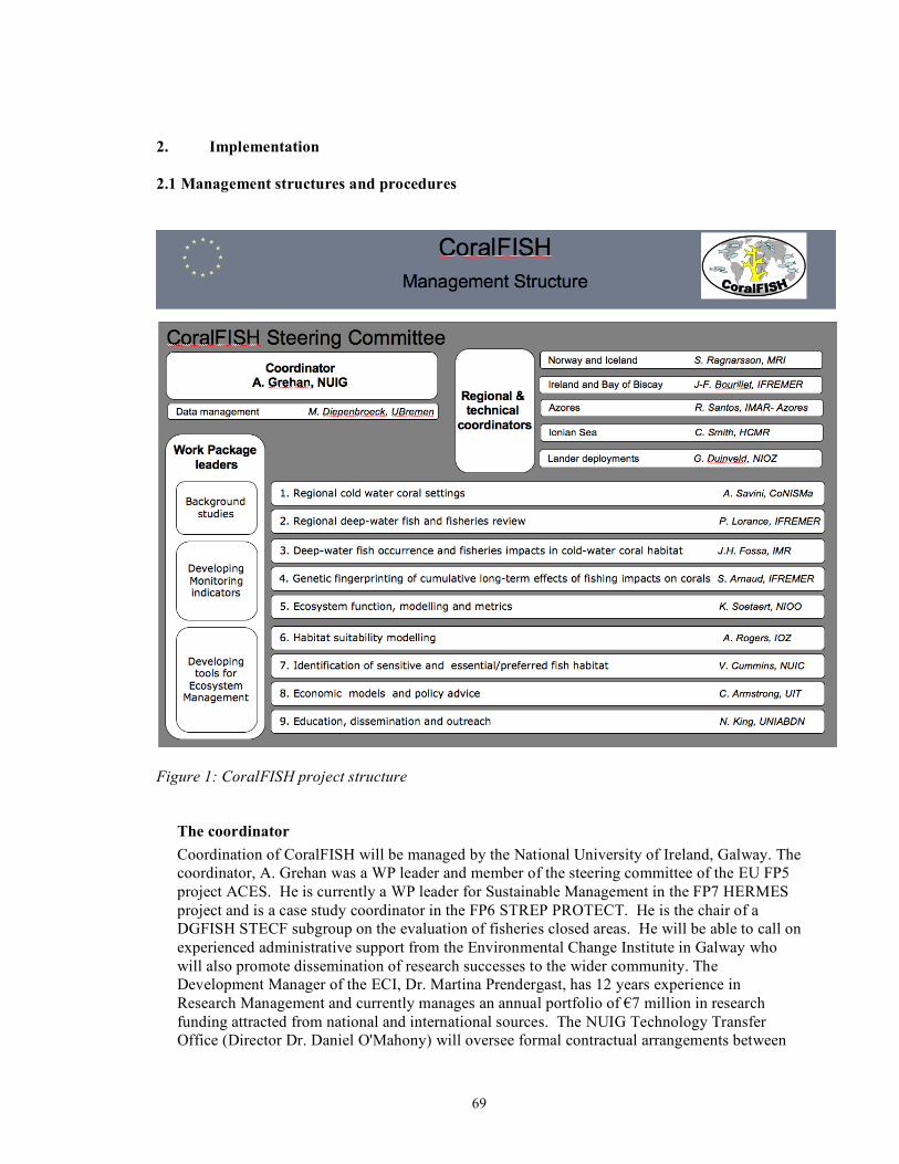
69
2. Implementation 2.1 Management structures and procedures
Figure 1: CoralFISH project structure
The coordinator Coordination of CoralFISH will be managed by the National University of Ireland, Galway. The coordinator, A. Grehan was a WP leader and member of the steering committee of the EU FP5 project ACES. He is currently a WP leader for Sustainable Management in the FP7 HERMES project and is a case study coordinator in the FP6 STREP PROTECT. He is the chair of a DGFISH STECF subgroup on the evaluation of fisheries closed areas. He will be able to call on experienced administrative support from the Environmental Change Institute in Galway who will also promote dissemination of research successes to the wider community. The Development Manager of the ECI, Dr. Martina Prendergast, has 12 years experience in Research Management and currently manages an annual portfolio of €7 million in research funding attracted from national and international sources. The NUIG Technology Transfer Office (Director Dr. Daniel O'Mahony) will oversee formal contractual arrangements between

70
the project and the Commission, and for all payments made by the Commission and for allocations to partners. The coordinator will oversee the preliminarily contract negotiation between partners and prepare the Consortium Agreement.
The partners The sixteen partners from 10 European countries are made up of 8 major marine institutes, 7 universities and one fishing industry SME (O'Malley Fisheries).
The work is organized into 1 project management WP (#10) and 9 scientific WPs covering background studies (two WPs), the development of monitoring indicators (three WPs) and the development of tools for ecosystem based management (four WPs).
The project encompasses a large geographical area covering several major European eco-regions. CoralFISH plans to carry out data acquisition in 6 contrasting study area. These case studies are clustered into 4 regions with one coordinator for each to oversee logistics. The clusters are:
- Nordic region including the reefs off Norway and the sponge beds off Iceland, - Mid-latitude NE Atlantic with the reefs on giant carbonates mounds (Porcupine Seabight,
Porcupine and Rockall Banks) and on interfluves and canyons on a passive margin (Bay of Biscay),
- The tropical Atlantic with the reefs on volcanic seamounts off the Azores - Mediterranean corals in the Ionian Sea.
The regional coordinators will be responsible for overseeing the development of standard data acquisition methodologies for survey of coral habitat and census of fish populations.
The CoralFISH Steering Committee The Steering Committee will assist the coordinator to monitor the progress of the work and manage the deliverables, to take decisions at milestones by bringing scientific points of view,
The Steering Committee will be chaired by the coordinator and is composed of the scientific WP leaders, the 4 regional coordinators and a technical coordinators for lander deployments. The final member of the committee will be the Pangaea data management. The 16 members represent 13 of the 16 partners. Meetings will be held every six months. Members have already successfully adopted SKYPE video conferencing during the formulation stages of the project proposal and this technology will continue to play a role in promoting contact between face to face meetings.
71
2.2 Individual participants Partner 1: National University of Ireland Galway (NUIG) The National University of Ireland, Galway, has traditionally played a major role in marine research in Ireland due to its strategic location as a gateway to the North Atlantic. The Department of Earth and Ocean Sciences (EOS) has a complement of 17 full-time academic staff including several with long experience of participation in European marine collaborative research projects. The Department is also involved in national marine research projects, particularly in oceanography and in geo-habitat mapping. The Department is affiliated with the Environmental Change Institute (ECI), an interdisciplinary and cross-faculty centre at NUI Galway. The ECI have managed numerous national projects and provided administration support for NUIG researchers co-ordinating FP6 projects such as BioMedNano and EUSAAR. Dr. Anthony Grehan Position: Senior Research Fellow in EOS Interests: Irish deep-water corals and their protection; habitat mapping with ROV's and
habitat prediction from acoustic remote sensing and environmental data; promotion of integrated ocean management.
Experience: 15 years experience in deep-sea ecological research. Involvement in several EU projects (including ECOMARGE-NB, BENGAL, ACES, ECOMOUND, AMASON). Currently member of scientific steering committee and WP leader in HERMES and cold-water coral case study coordinator in PROTECT, FP6 projects. He is a member of ICES WGMHM and WGDEC. Chair of STECF subgroup on evaluation of CFP fisheries closed areas. 20 peer-reviewed papers.
Dr. Martin White Position: College Lecturer in EOS Interests: Hydrographic processes at the shelf edge. The relationships between hydrography
and various ecosystems such as fisheries, deep water cold corals, and other benthic systems.
Experience: 19 years experience in physical oceanography (12 as a Post-Doc) and has been involved in several EU programs (including OMEX, ACES, ECOMOUND, OASIS). Currently participating in HERMES and a number of national projects. 21 peer-reviewed papers.
Dr. Colin Brown Position: Senior Lecturer in EOS and an Honorary Professor at the Dublin Institute for Advanced Studies. Interests: Developing quantitative methods to infer the composition and physical properties
of sediment from swath acoustic and single channel seismic reflection data; acoustic classification of sediments and prediction of habitats from acoustic remote sensing and environmental data.
Experience: 25 years as a permanent staff member. He is a member of the American Geophysical Union, European Geophysical Union, Royal Astronomical Society, Society of Exploration Geophysicists, the Irish Geological Association and is Editor of Geophysical Prospecting. 25 peer-reviewed papers.
Selected Publications Grehan AJ, Unnithan V, Olu K, Opderbecke J (2005) Fishing impacts on Irish deep-water coral
reefs: making a case for coral conservation. In: Thomas J, Barnes P (eds) Proceeding from the Symposium on the Effects of Fishing Activities on Benthic Habitats: Linking Geology,
72
Biology, Socioeconomics and Management. American Fisheries Society, Bethesda, Maryland, USA, p in press
Long R, Grehan A (2002) Marine Habitat protection in a coastal Member State of the European Union: the case of deep-water coral conservation in Ireland. International Journal of Marine and Coastal Law 17:241-269
White M (2007) Benthic dynamics at the carbonate mound regions of the Porcupine Sea Bight continental margin. International Journal of Earth Sciences 96(1):1-9
White M, Mohn C, de Stigter H, Mottram G (2005) Deep water coral development as a function of hydrodynamics and surface productivity around the submarine banks of the Rockall Trough , NE Atlantic. In: Freiwald A, Roberts JM (eds) Cold-water corals and Ecosystems. Springer-Verlag, Berlin Heidelberg, p 503-514
Wilson MFJ, O’Connell B, Brown C, Guinan JC, Grehan AJ (in press) Multi-scale terrain analysis of multibeam bathymetry data for habitat mapping on the continental slope. Marine Geodesy: 5th Spec Issue on Marine and Coastal Geographic Information Systems, 30
73
Partner 2: Institute of Marine Research (IMR) IMR is the principal research and advisory body for fisheries, marine resources and environment and aquaculture in Norway (www.imr.no). IMR located in Norway has excellent facilities for both experimental and survey studies and is one of the largest and most comprehensive Marine Research Institutes in Europe owning some of the most advanced marine research vessels and laboratories in the world. Its facilities, that extend from the southern to the northern part of the country, include a chain of research and field stations, laboratories and over 10 research vessels, ROVs and AUVs. In total the institute employs 650 persons and has an annual budget of €80 million (www.imr.no). IMR has first-class expertise and experience in performing studies in the ecology and genetics of marine species and organisms. The Institute has had long years of experience with coordinating and administering large-scale research projects both at national and international levels, with the most recent being the MAR-ECO project. Jan Helge Fosså Position: Senior scientist in the Benthic Habitats and Shellfish Research Group, IMR. Interests: Ecology of cold-water coral reefs, effects of fisheries, management of benthic
ecosystems. Experience: Leader of the deep-water coral research project at IMR since the start in 1997.
Research spans from studies of carrying capacity of fjords, ecology of kelp beds, plankton and hyperbenthos. Has been a member of the steering board for the National Research Programme on Biodiversity of the Research Council of Norway. Presently the main advisor on coral ecosystems to the Norwegian authorities and a member of the steering committee of HERMES (Hot Spot Ecosystem Research on the Margins of European Seas). Awarded the "Biodiversity Prize" for 2006 by SABIMA. The prize is awarded to "a person, organization or institution performing an exceptional contribution for the preservation of biological diversity".
Odd Aksel Bergstad Position: Senior scientist in the Deep-water Species Research Group, IMR. Interests: Fish population biology and community ecology. Impacts of fisheries on structure
and dynamics of communities. Experience: Leader of several national and international fish ecology projects, 1984-present.
From 2001 to 2005, chair of the ICES Working Group on the Biology and Assessment of Deep-sea Fisheries Resources. Since 2000, leader of the international and multidisciplinary MAR-ECO project, a field project of the Census of Marine Life programme (www.mar-eco.no) in the mid-Atlantic. PI of many cruises on Norwegian research vessels, 1985-. In 2004, winner of the Norwegian Research Council Award for Excellence in Communication of Science. In 2006, EU Descartes Prize Laureate for Excellence in Science Communication.
Pål B. Mortensen Posistion: Senior scientist in the Benthic Habitats and Shellfish Research Group, IMR. Interests: Coral ecology, benthic biodiversity, community structure, effects of fisheries. Experience: PhD on the distribution, ecology and growth of Lophelia pertusa. Participant on
various Norwegian deep-water coral research projects by the University of Bergen, The Norwegian State Oil Company, and the Institute of Marine Research. Principal scientist on a project on Coral Ecosystems in Atlantic Canada at Bedford Institute of Oceonography. Ten years of experience from deep-water coral research.
Selected Publications Bergstad OA, Bjelland O, Gordon JDM (1999) Fish communities on the slope of the eastern
Norwegian Sea. Sarsia 84:67-78

74
Bergstad OA, Wik ÅD, Hildre Ø (2003) Predator-prey relationships and food sources of the Skagerrak deep-water fish assemblage. Journal of Northwest Atlantic Fishery Science 31:165-180
Fosså JH, Mortensen L, B, Christensen O, Lundälv T, Svellingen I, Mortensen PB, Alvsvåg J (2005) Mapping of Lophelia reefs in Norway: experiences and survey methods. In: Freiwald A, Roberts JM (eds) Cold-water corals and ecosystems. Springer-Verlag, Berlin Heidelberg, p 359-391
Fosså JH, Mortensen PB, Furevik DM (2002) The deep-water coral Lophelia pertusa in Norwegian waters: distribution and fishery impacts. Hydrobiologia 471:1-12
Mortensen PB, Fosså JH (2006) Species diversity and spatial distribution of invertebrates on Lophelia reefs in Norway. Proceedings of the 10th International Coral Reef Symposium, Okinawa, Japan, p 1849-1868
Mortensen PB, Hovland MT, Fosså JH, Furevik DM (2001) Distribution, abundance and size of Lophelia pertusa coral reefs in mid-Norway in relation to seabed characteristics. Journal of the Marine Biological Association of the United Kingdom 81:581-597

75
Partner 3: Marine Research Institute (MRI) The Marine Research Institute (MRI), established in 1965, is a government institute under the auspices of the Ministry of Fisheries with an annual turnover rate of 21 million euros. The institute has five branches and a mariculture laboratory, and it employs 170 people. It also operates two research vessels of 56 m and 70 m length. The main research activities of the MRI involve collection of environmental data (oceanography, nutrients, primary and secondary production) on a variety of temporal and spatial scales, as well as data on the distribution and abundance of economically exploitable fish species. Much of this research forms the basis for the advice provided to the Ministry of Fisheries for stock management. The MRI has long experience in marine ecosystem research, mainly in the continental shelf waters of Iceland but also in deeper offshore waters. MRI conducts research in collaboration with foreign institutes and international scientific organisations including ICES, NEAFC, NAFO, NAMMCO and ICCAT. Stefán Áki Ragnarsson Position: Benthic ecologist Interests: Fishing impacts, cold-water corals, role of area closures for benthic and fish
communities and vulnerable habitats, MPA considerations, habitat mapping, ecosystem approach
Experience: Gear impact studies (otter-trawl, hydraulic and scallop dredge), ecosystem approach to fisheries, analysis of fishing effort, by-catch and fish diet data, underwater observations (camera and ROV).
Jón Sólmundsson Position: Fishery scientist Interests: Distribution, migration and stock fluctuations of groundfish species, area closures,
ecosystem based fishery management and seabird feeding ecology. Experience: Analysis of fish diets, project leader of the annual Icelandic groundfish survey Guðrún Helgadóttir Position: Marine geologist Interests: Multibeam mapping of the seabed and marine geology Experience: Analysis of multibeam data shallow seismic data and palaeoceanography Selected Publications Guijarro Garcia E, Ragnarsson SA, Eiríksson H (2006 ) Effects of Scallop dredging on macrobenthic communities in West Iceland. Journal of Marine Science 63:434-443 Jaworski AJ, Ragnarsson SA (2006) Feeding habits of demersal fish in Icelandic waters: a
multivariate approach. ICES Journal of Marine Science 63:1682-1694 Jaworski AJ, Solmundsson J, Ragnarsson SÁ (2006) The effect of area closures on the demersal
fish community off the east coast of Iceland. ICES Journal of Marine Science 63:897-911 Ragnarsson SA, Steingrímsson SA (2003) Spatial distribution of otter trawl effort in Icelandic
waters: comparison of measures of effort and implications for benthic community effects. ICES Journal of Marine Science 60:1200-1215
Solmundsson J, Karlsson H, Palsson J (2003) Sexual differences in spawning behaviour and catchability of plaice (Pleuronectes platessa) west of Iceland. Fisheries Research 61:57-71
Solmundsson J, Palsson J, Karlsson H (2005) Fidelity of mature Icelandic plaice (Pleuronectes platessa) to spawning and feeding grounds. ICES Journal of Marine Science 62:189-200
76
Partner 4: Institut Français de Recherche pour l'Exploitation de la Mer (IFREMER ) IFREMER, a public body created in 1984, is the only French research organisation with an entirely maritime purpose. It operates under the joint auspices of the Ministries of Research, Agriculture and Fisheries, Amenities and Transport, and Ecology and Sustainable development. Being involved in all the marine science and technology fields, IFREMER has the capability of solving different problems with an integrated approach. IFREMER’s scope of actions can be divided into four main areas, each of them including different topics as described hereunder:
1. Understanding, assessing, developing and managing the ocean resources 2. Improving knowledge, protection and restoration methods for marine environment 3. Production and management of equipment of national interest 4. Supporting the socio-economic development of the maritime world
Jean-François Bourillet Position: Leader of the IFREMER project 'Exploration and Mapping of Margins' Interests: Marine geologist specialist of passive margin sedimentation and geomorphology Experience: 15 years in the Bay of Biscay for geomorphological and ecosystemic studies Dr Karine Olu Position: Permanent scientist Interests: Deep-sea biologist, cold-seep ecosystem, habitat, stock and biodiversity assessment Experience: ICES working group, HERMES, NoE MARBEF & Census of Marine Life Dr Pascal Lorance Position: Leader of the IFREMER project 'Ecosystem Approach to Fisheries in the Bay of
Biscay' Interests: Fisheries ecology, fish biodiversity, stock assessment. Experience: ICES working groups and NoE MARBEF Dr Sophie Arnaud-Haond Position: Permanent scientist Interests: Marine ecologist, population genetics, biogeography of species from deep sea Selected Publications Arnaud-Haond S, Teixeira S, Massa S, Billot CP, Saenger P, Coupland G, Duarte CM, Serrao EA (2006) Genetic structure at range-edge: low diversity and high inbreeding in SE Asia mangrove (Avicennia marina) populations. Molecular Ecology 15:3515-3525 Bourillet J-F, Reynaud J-Y, Baltzer A, Zaragosi S (2003) The “Fleuve Manche”: the sub-marine
sedimentary features from the outer shelf to the deep-sea fans. Journal of Quaternary Science 18:261-282
Bourillet J-F, Zaragosi S, Mulder T (2006) The French Atlantic margin and the deep sea submarine systems. Geo-Marine Letters 26:311-315
Lorance P, Trenkel VM (2006) Variability in natural behaviour, and observed reactions to an ROV, by mid-slope fish species. Journal of Experimental Marine Biology and Ecology 332:106-119
de Mol B, Kozachenko M, Wheeler A, Alvares H, Henriet JP, Olu-Le Roy K (2007) Thérèse Mound: a case study of coral bank development in the Belgica Mound Province, Porcupine Seabight. International Journal of Earth Sciences 96:103-120
Olu-Le Roy K, Sibuet M, Fiala-Médioni A, Gofas S, Salas C, Mariotti A, Foucher JP, Woodside J (2004) Cold seep communities in the deep eastern Mediterranean Sea: composition, symbiosis and spatial distribution on mud volcanoes. Deep-Sea Research I 51:1915-1936

77
Partner 5: Institute for Marine Research (IMAR-Azores) Centre of IMAR of the University of the Azores - Department of Oceanography and Fisheries (IMAR/UAz) is involved in research and educational activities related to the ecology and ecosystem-based management of island, open ocean and deepwater marine ecosystems. It focuses primarily on study of the biology, genetics and population dynamics of fishing resources including pelagic, inshore, demersal and deep-sea fish with commercial interest in the Mid-Atlantic region., The unit is currently developing ecosystem models for the region. This research unit supports some 50 research fellows, including several postdoctoral researchers, PhD and MSc students and visiting international scientists. Members of the unit have participated as partners or coordinators in several previous EU projects. The group has long been involved with governmental and non-governmental partners, at the international, European and national levels, in the implementation of Marine Protected Areas, fisheries monitoring programs and research for biodiversity conservation. IMAR /UAz has 30 years of experience based on detailed research in shallow, deep-sea and oceanic ecosystems that formed the basis for the creation of both existing and proposed regional and offshore MPAs. The study of the adverse impacts of fisheries in target and non-target species and ecosystems has been one of the major objectives of the Institution’s research, including several years of international projects on longline turtle by-catch mitigation and tuna fisheries monitoring. Both research and technological development are being conducted under close cooperation with international and national institutions involved in marine sciences and technologies. IMAR/UAz will participate in workpackages 1, 2, 3, 5 and 8. Dr Ricardo Serrão Santos Position: Principal Investigator (UAz), Director of DOP, Pro-Rector of the UAC, President
of IMAR Interests: Marine conservation of habitats and biodiversity of shallow and deep-sea
ecosystems, implementation of MPAs and experimental evaluation of their benefits, and experimental studies of deepsea organisms.
Experience: Member of several international Steering Committees including MarBEF, and participated in two Census of Marine Life programs. Member of the Scientific Council for Marine Sciences and Environment, Portuguese Delegate at the Committee of Research Infrastructures at the EC-DG Research. Member of ICES WGMHM, co-chair of the WG Monitoring and Observatories of InterRidge and co-chair of the WG on Deep Sea Research. Member of the Intersectorial Oceanographic Commission, and co-ordinator and/or partner of several national, European and international scientific projects. Experienced in ocean scientific cruises including those involving submersibles. Coordinated the research and management proposals for the network of Natura 2000 in the Azores. In 2002 he was awarded a Gift to the Earth by WWF for his involvement in the designation of Lucky Strike and Menez Gwen as MPAs.
Dr Telmo Morato Position: Post-Doc fellow Interests: Developing ecosystem-based tools for fisheries management Experience: Marine Fisheries Biologist involved in several research projects focusing on deep-
sea and seamounts fisheries management and ecosystem modelling. Has recently demonstrated that global landings of marine fish have shifted to deeper water species over the last 50 years. He has identified the deep-sea as the new candidate for conservation during the 21st century. Scientific output mainly dedicated to fisheries management, ecosystem modelling, and aspects of the Azores ecosystems. Publications include 20 contributions to peer-reviewed journals and many other papers and reports. Currently editing a book on “Seamounts Ecology, Fisheries and Conservation”.
Selected Publications
78
Morato T, Cheung WWL, Pitcher TJ (2006) Vulnerability of seamount fish to fishing: fuzzy analysis of life history attributes. Journal of Fish Biology 68:209-221
Morato T, Pitcher TJ (2005) Ecosystem simulations in support of management of data-limited seamount fisheries. In: Kruse GH, Gallucci VF, Hay DE, Perry RI, Peterman RM, Shirley TC, Spencer PD, Wilson B, Woodby D (eds) Fisheries assessment and management in data-limited situations, Lowell Wakefield Fisheries Symposium Series Vol 21. Alaska Sea Grant, University of Alaska, Fairbanks, p 467-486
Morato T, Watson R, Pitcher TJ, Pauly D (2006) Fishing down the deep. Fish and Fisheries 7(1):24-34
Pitcher TJ, Morato T, Hart PJB, Clark M, Haggan N, Santos R (eds) (in press) Seamount fishes: ecology and life histories. Blackwell, Oxford, UK
Porteiro FM, Sutton T (in press) Midwater fish assemblages and Seamounts. In: Pitcher TJ, Morato T, Hart PJB, Clark M, Haggan N, Santos R (eds) Seamount fishes: ecology and life histories, Fish and Aquatic Resources Series. Blackwell, Oxford, UK
Santos RS, Hawkins S, Monteiro LR, Alves M, Isidro EJ (1995) Case studies and reviews. Marine research, resources and conservation in the Azores. Aquatic Conservation: Marine and Freshwater Ecosystems 5:311-354
79
Partner 6: Hellenic Centre for Marine Research (HCMR) HMCR is a highly active centre for marine research, created in 2003 from the merger of the National Centre for Marine Research with the Institute of Marine Biology of Crete. HCMR consists of 5 institutes concerning oceanography, fisheries, aquaculture, marine biology and genetics and inland waters. The Centre has been extremely active in all the EU framework programmes, involved in numerous projects as coordinator or partner. The Centre has modern well-equipped facilities including two research vessels (61 m R/V Aegaeo and 26 m R/V Philia) equipped with a large suite of geophysical sampling equipment (Multibeam, side scan, sub-bottom profiler along with advanced acquisition and processing software, CTDs and sediment samplers). The centre also has a 600 m 2-man submersible and a 2000 m ROV system. Dr Chris Smith Position: Senior researcher (Marine Biologist) Interests: Invertebrate fisheries, fishing impacts, underwater vehicles Experience: Involved a variety of EU projects on fisheries-environment interactions and the
application of new technologies over the last 18 years. Responsible for the HCMR ROV systems. Workpackage leader in a number of EU-Projects: AMADEUS, ARAMIS, AMASON, COST-IMPACT, NECESSITY.
Chryssi Mytilineou Position: Researcher (Fisheries Biologist) Interests: Fisheries biology, ecology and dynamics Experience: Involved in research related to "New Fisheries Resources" for the last 10 years,
particularly deep-water resources and fisheries, through participating in and coordinating research projects funded by the EU, collaborating with other experienced scientific teams in this activity, participating in symposia and publishing scientific papers.
Dr. Vassilis Lykousis Position: Research Director (Geologist) Interests: Downslope sedimentological processes, biogeochemical cycles, slope stability,
sediment mass gravity processes, quaternary sediment sequences and sedimentary facies
Experience: Co-ordinator or workpackage leader of several important EU projects including INTERPOL, EURODOM, MTP-II-MATER CINCS, ASSEM, EURODELTA, ANAXIMANDER (RTN).
Dr. Dimitris Sakellariou Position: Senior Researcher (Geologist) Interests: Geodynamics, neotectonics, active faults, geological hazards, seismic stratigraphy,
quaternary sediment sequences, sea-floor imaging, applications for underwater archaeology
Experience: Chief scientist in most of the cruises devoted to deep-water archaeological surveys, responsible for side-scan-sonar and sub-bottom profiling interpretation and principal investigator in ASSEM, SEISCANEX, ANAXIMANDER, 3HAZ, HERMES, TRANSFER.
Selected publications Lykousis V, Sakellariou D, Moretti I, Kaberi H (2007) Late Quaternary basin evolution of the
Gulf of Corinth: Sequence stratigraphy, sedimentation, fault-slip and subsidence rates. Tectonophysics:in press
Lykousis V, Sakellariou D, Rousakis G (2003) Prodelta slope stability and associated coastal hazards in tectonically active margins: Gulf of Corinth (NE Mediterranean). In: Locat J,
80
Mienert J (eds) Submarine Mass Movements and their Consequences First International Symposium, Advances in Natural and Technological Hazards Research Vol 19. Kluwer Academic Publishers, p 433-440, 540pp
Mytilineou C, Kavadas S, Politou C-Y, Kapiris K, Tursi A, Maiorano P (2006) Catch composition in red shrimp (Aristaeomorpha foliacea and Aristeus antennatus) grounds in the eastern Ionian Sea. Hydrobiologia 557:155-160
Mytilineou C, Politou C-Y, Papaconstantinou C, Kavadas S, D’Onghia G, Sion L (2005) Deep-water fish fauna in the Eastern Ionian Sea. Belgian Journal of Zoology 135(2):229-233
Smith CJ, Marrs SJ, A ARJ, Papadopoulou K-N, Hills JM (2003) Evaluation of the underwater television technique for fisheries-independent stock assessment of Nephrops norvegicus from the Aegean (Eastern Mediterranean). Marine Ecology Progress Series 256:161-170
Smith CJ, Papadopoulou K-N, Diliberto S (2000) Impact of Otter trawling on an eastern Mediterranean commercial fishing ground. ICES Journal of Marine Science 57:1340-1351

81
Partner 7: Consorzio Nazionale Interuniversitario per le Scienze del Mare (CoNISMa) The CoNISMa (Consorzio Nazionale Interuniversitario per le Scienze del Mare) was established in February, 1994; it is a non-profit research organisation (public body) established as a legal entity, having an administrative board whose members are appointed by the Italian Ministry of Universities and Scientific Research. Today, 29 Italian Universities are linked to CoNISMa and more than 600 researchers and university technicians participate in the Local Research Unit of CoNISMa activities. CoNISMA aims to promote and co-ordinate multidisciplinary research and other scientific and related activities in the field of Marine Sciences, favouring the co-operation of the associated Universities with other Universities, and with public and private Research Centres. CoNISMa owns the UNIVERSITATIS, a modern 45m long research vessel built in 2003 and equipped for a complete interdisciplinary study of the marine environment in the Mediterranean Sea, covering geophysical, oceanographic and biological purposes: the vessel is equipped with a range of geophysical devices for seafloor mapping (Side Scan Sonar, MultiBeam echosounders, SingleBeam echosounders, Magnetometer, Parametric Sediment Echo Sounder) and sediment sampling can be performed by gravity corer, box-corer, mini-corer, grab and experimental fishing gears to lower environmental impact. In the past 10 years CoNISMa has participated in more than 20 U.E. research projects as coordinator or partner (SYNDEM, HAKE, EUROROCK, MEDLAND, CODEPASS, GENHAKE, MECO, SAP, EMMA, DESEAS, ADIOS, INTEREPOL, BIODEEP, NOMIRACLE, CORALZOO, EPICA, EUROCEANS, HERMES, BIOTOX, ALARM, SYNDEM, MARBEF, MERSEA, REEFRES, JASON, SESAME). Prof. Gianfranco D’Onghia Position: Associate Professor of Ecology – University of Bari (Italy). Interests: Life strategies and population dynamics of deep-water species, community
ecology and marine biodiversity. Experience: Involved in scientific research programs for over 20 years (e.g. MEDITS-EC-DGXIV
94/057; DEEP-FISHERIES-EC-DGXIV-FAIR CT95-0655; HAKE-EC-DGXIV 95/031; DESEAS-EC-DGXIV 2000/39). Co-ordinator and scientist responsible for study projects regarding living marine resources in the Ionian Sea. Invited as expert to national and international commissions regarding deep-water resources and sensitive habitats. He has (co)-authored over 100 scientific publications in national and international journals. Co-editor of the volume “Mediterranean deep-sea biology”, Scientia Marina, 68 (suppl.3).
Dr. Alessandra Savini Position: Researcher (Marine Geologist) Interests: Seafloor mapping, processes of sedimentation and interaction with deep sea
ecosystems. Experience: Involved in seagoing scientific research programs and industry-related applied
scientific projects since 1999. Was chief scientist on 10 cruises in the private sector and on 2 scientific research cruises. Seabed data interpretation refers mainly to the identification of sediment dynamics and to habitat mapping. Co-project coordinator of the National Italian projects APLABES (2004 to 2006) and MESC (2006 to 2008). University lecturer in marine geology. Has (co)-authored 4 peer-reviewed publications.
Selected Publications D’Onghia G, Basanisi M, Tursi A (2000) Population structure, age and growth of macrourid fish
from the upper slope of the Eastern-Central Mediterranean. Journal of Fish Biology 56 (5):1217-1238
D'Onghia G, Politou C-Y, Bozzano A, Lloris D, Rotlant G, Sion L, Mastrototaro F (2004) Deep-water fish assemblages in the Mediterranean Sea. Scientia Marina 68:87-99

82
D'Onghia G, Sion L, Maiorano P, Mytilineou C, Dalessandro S, Carlucci R, Desantis S (2006) Population biology and life strategies of Chlorophthalmus agassizii Bonaparte, 1840 (Pisces: Osteichthyes) in the eastern-central Mediterranean Sea. Marine Biology 149:435-446
Fusi N, Savini A, Corselli C (2006) High resolution (chirp) survey in the ionian sea (Italy, central Mediterranean): seismic evidence of mud diapirism and coral mounds. Annals of Geophysics 49:751-765
Taviani M, Remia A, Corselli C, Freiwald A, Malinverno E, Mastrototaro F, Savini A, Tursi A (2005) First geo-marine survey of living cold-water Lophelia reefs in the Ionian Sea (Mediterranean basin). Facies 50:409-417
Yakimov MM, Cappello S, Crisafi E, Tursi A, Savini A, Corselli C, Scarfi S, Giuliano L (2006) Phylogentic survey of metabolically active microbial communities associated with the deep-sea coral Lophelia pertusa from the Apulian plateau, Central Mediterranean Sea. Deep Sea Research Part I: Oceanographic Research Papers 53(1):62-75

83
Partner 8: Nederlands Instituut voor Ecologie (NIOO) The Netherlands Institute of Ecology is the largest research institute of the Royal Netherlands Academy of Arts and Sciences. It consists of three centres, one of them (CEME) dealing with the ecology of estuaries and marine systems, including the deep sea. The expertise of the CEME is in benthic microbiology, geochemistry and biology including deep-sea experiments, modelling of benthic food webs and diagenetic processes. The CEME plays a major role in EU projects, co-ordinating many projects, including the Network-of-Excellence MARBEF (FP6). Prof. Karline Soetaert Position: Senior Scientist, professor Interests: Food webs, Ecological modelling, Biogeochemistry Experience: Involved in FP4, FP5 (OMES, ORFOIS), FP6 projects (HERMES, ecosystem
modelling workpackage leader). Has extensive experience in biogeochemical and ecological modelling, including the mathematical aspects. Has (co)-authored more than 70 peer-reviewed publications, is part-time professor in the Universities of Ghent and the Free University of Brussels (Belgium).
Dr. Dick van Oevelen Position: Post-doctoral fellow Interests: Modelling marine benthic food webs Experience: Experienced in the modelling of marine benthic food webs, ranging from intertidal
and coastal sediments to abyssal plains. Hands-on experience in in-situ experimentation, protein and stable isotope biogeochemistry. Actively involved in FP6 project (HERMES), responsible for the modelling of sedimentary, coldwater coral and cold seep food webs. Principal investigator in the Statoil funded research program CORAMM (Coral Risk Assessment, Monitoring and Modelling). Has (co)-authored 6 peer-reviewed papers and one book chapter.
Selected Publications Kones JK, Soetaert K, van Oevelen D, Owino JO, Mavuti K (2006) Gaining insight into food
webs reconstructed by the inverse method. Journal of Marine Systems 60:153-160 Soetaert K, deClippele V, Herman P (2002) Femme, a flexible environment for mathematically
modelling the environment. Ecological Modelling 151:177-193 Soetaert K, Middelburg J, Herman PMJ, Buis K (2000) On the coupling of benthic and pelagic
biogeochemical models. Earth-Science Reviews 51:173-201 van Oevelen D, Moodley L, Soetaert K, Middelburg JJ (2006) The trophic significance of
bacterial carbon in a marine intertidal sediment: results of an in situ stable isotope labelling study. Limnology and Oceanography 51:2349-2359
van Oevelen D, Soetaert K, Middelburg JJ, Herman PMJ, Moodley L, Hamels I, Moens T, Heip CHR (2006) Carbon flows through a benthic food web: Integrating biomass, isotope and tracer data. Journal of Marine Research 64:453-482
Veuger B, van Oevelen D, Middelburg JJ, Boschker HTS (2006) Fate of 13C labeled bacterial proteins and peptidoglycan in an intertidal sediment. Limnology & Oceanography 51:1572-1580

84
Partner 9: Institute of Zoology (IOZ) The Institute of Zoology (IoZ) is the research division of the Zoological Society of London. The Institute is based at ZSL's Regent’s Park site, in London. It is a government-funded research institute specialising in scientific issues relevant to the conservation of animal species and their habitats. Research is organized into six thematic areas which span evolutionary biology, genetics, ecology, reproductive biology and wildlife epidemiology. A senior research fellow in the Institute leads each one of these, but staff are not restricted to working within any one theme. The Institute of Zoology was graded 4 in the 1997-2001 UK Research Assessment Exercise and published more than 100 papers in 2005/6 including 5 in Nature or Science. In 2000 the institute formed a new strategic partnership with the Department of Zoology, the University of Cambridge. The Institute currently has approximately 35 academic, post-doctoral and veterinary staff, 24 research assistants and technicians, and 9 administrative and support staff. It also runs a high-quality postgraduate training programme with 14 PhD students, plus 17 MSc students and other visitors. Core funding comes from the Higher Education Funding Council for England, the same body that supports universities. Additional research funding for specific projects comes from UK research councils (e.g. NERC, BBSRC, EPSRC) and research charities (e.g. Wellcome and Leverhulme trusts), the European Union and private funding sources, as in university departments. Facilities at the IOZ include fully-equipped molecular genetics laboratories, reproductive biology laboratories and general laboratory facilities including low temperature freezers. There are also excellent holding facilities for aquatic animals through collaboration with the ZSL’s aquarists. The site also maintains the Zoological Society’s Library, an excellent resource for research. Dr. Alex David Rogers Position: Senior Research Fellow Interests: Marine ecology, deep-sea ecology, molecular ecology and phylogenetics. Experience: 15 years experience in marine biology and molecular ecology. Special expertise in
deep-sea ecology, especially of seamounts and cold-water coral ecosystems. Particularly interested in the relationships between animal life history and genetic structure of populations and in the evolution of marine species. Also experience of polar ecology (Antarctic). 45 papers in peer-reviewed journals, 7 book chapters, 2 thematic volumes edited, 1 book published and 23 Reports, including for several NGOs (WWF, Greenpeace), the UN International Seabed Authority, UN Environmental Programme and the UN Secretary General for the Law of the Sea.
Selected Publications Aboim MA, Menezes GM, Pinho MR, Schlitt T, Rogers AD (2005) Genetic structure and history
of populations of the deep-sea fish Helicolenus dactylopterus (Delaroche 1809) inferred from mtDNA sequence analysis. Molecular Ecology 14:1343-1354.
Le Goff-Vitry MC, Pybus OG, Rogers AD (2004) Genetic structure of the deep-sea coral Lophelia pertusa in the North East Atlantic revealed by microsatellites and ITS sequences. Molecular Ecology 13:537-549
Le Goff-Vitry MC, Rogers AD, Baglow D (2004) A deep-sea slant on the molecular phylogeny of the Scleractinia. Molecular Phylogenetics and Evolution 30:167-177
Rogers AD (1999) The biology of Lophelia pertusa (Linnaeus 1758) and other deep-water reef-forming corals and impacts from human activities. International Review of Hydrobiology 84:315 – 406
Rogers AD, Morley S, Fitzcharles E, Jarvis K, Belchier M (2006) Genetic structure of Patagonian toothfish (Dissostichus eleginoides) populations on the Patagonian Shelf and Atlantic and western Indian Ocean Sectors of the Southern Ocean. Marine Biology 149:915-924
85
Stockley BM, Menezes G, Pinho MR, Rogers AD (2005) Genetic population structure of the black-spot sea bream (Pagellus bogaraveo) from the NE Atlantic. Marine Biology 146:793-804

86
Partner 10: University of Tromsø, (UIT) The Norwegian College of Fishery Science (NCFS), situated at 70 degrees north and close to the Barents Sea, has a particular responsibility for the development of fundamental and scientific expertise within all areas of fisheries and aquaculture research in Norway. NCFS is also responsible for educating candidates for employment in the fishing industry and fisheries management. NCFS has four departments: Department of Aquatic Biosciences, Department of Marine Biotechnology, Department of Economics and Management, Department of Social Science and Marketing. The number of students at NCFS is steadily increasing, and is expected to reach 700 in a year or two. The College offers a number of BSC, MSC, and PHD degree programmes. NCFS has a permanent staff of 130, 60 of these engaged in teaching and research activities. Additionally, externally funded contract staff includes c. 50 people, the majority performing research. The breadth of professional competence provides the NCFS with exclusive opportunities for basic and applied research in natural and social sciences. A co-operative partnership with R&D institutions in Norway and other countries gives NCFS a solid foundation for conducting teaching and research within fisheries sciences. Dr. Claire W. Armstrong Position: Professor of Resource Economics and Management at the Norwegian College of
Fisheries Science, University of Tromsø. Interests: Bioeconomic modelling, Marine ecosystem management and fisheries economics Experience: Defended her PhD in 1998 on bioeconomic modelling and fisheries management,
and has published widely in international journals. Involved in several EU projects in marine research, such as HERMES, PROTECT and INCOFISH; a has managed a project financed by the Norwegian Research Council on the economics of marine protected areas.
Selected Publications Armstrong CW (2007) A note on the ecological-economic modelling of marine reserves. Ecological Economics 62:242-250 Armstrong CW (in press) Using history dependence to design a dynamic tradeable quota system
under market imperfections. Environmental and Resource Economics Armstrong CW, Skonhoft A (2006) Marine reserves: A bio-economic model with asymmetric
density dependent migration. Ecological Economics 57(3):466-476 Skonhoft A, Armstrong CW (2005) Conservation of wildlife. A bio-economic model of a wildlife
reserve under the pressure of habitat destruction and harvesting outside the reserve. Natural Resource Modeling 18(1):69-90
Sumaila UR, Armstrong CW (2006) Distributional effects of Marine Protected Areas: A study of the North-East Atlantic cod fishery. Land Economics 82(3):321-332
Watzold F, Drechsler M, Armstrong CW, Baumgartner S, Grimm V, Huth A, Perrings C, Possingham HP, Shogren JF, Skonhoft A, Verboom-Vasiljev J, Wissel C (2006) Ecological-economic modeling for biodiversity management: potential, pitfalls, and prospects. Conservation Biology 20:1034-1041

87
Partner 11: University of Aberdeen (UNIABDN) The University was founded by Bishop William Elphinstone in 1495 and now with 11,000 students and nearly 3,000 staff, it is at the forefront of teaching and research in medicine, the humanities and sciences. Four Nobel prizes have been awarded to researchers at the University. Aberdeen is an international university built on serving one of the most dynamic regions in Europe with a major activity in offshore and sub sea technology. The Oceanlab opened in September 2001 is a unique facility designed for development testing and servicing of deep ocean autonomous vehicles and other instrumentation. With over 1100m2 of working space there is a chilled pressure vessel rated to 800bar, an immersion tank 5m deep, and environmental and vibration test chambers. The Oceanlab team has been responsible for over 500 deployments of autonomous platforms at depths from 500m to 5900m in the Atlantic and Pacific Oceans and in the Mediterranean Sea. Professor I.G. (Monty) Priede Position: Head of Oceanlab, University of Aberdeen Experience: Has co-ordinated several EU research programmes in the Fisheries and Marine
Science and Technology Sector including ALIPOR (Autonomous Lander Instrument Packages for Oceanographic Research) and the FP5 programme, ESONET European Sea Floor Observatory Network. He has extensive experience of sea-going research and was principal scientist on two cruises of the RRS Discovery during which up to 15 landers were deployed from the research vessel. Professor Priede has a PhD from the University of Stirling and DSc from University of Aberdeen. He is a Fellow of the Royal Society of the Edinburgh, Scotland’s national academy.
Dr. Phil M. Bagley Position: Engineering manager of Oceanlab, University of Aberdeen Interests: Engineering for deep sea research. Experience: Over 15 years of experience in underwater systems engineering, with field
experience in the Atlantic and Pacific Oceans, and Mediterranean Sea. His speciality is low power robust logging systems and underwater acoustic telemetry.
Dr. Nicola J. King Position: Postdoctoral Research Fellow, Oceanlab, University of Aberdeen Interests: Deep-sea scavenging fish ecology and distribution. Experience: Abundance, distribution and species composition of deep-sea demersal fish,
specialising in scavenging fish ecology. She has worked with baited landers for over 3 years and has field experience in Atlantic and Sub Antarctic deep-sea systems. In addition she has experience in image analysis techniques, deep-sea fish taxonomy, public outreach, science education and project administration.
Selected Publications Bagley PM, Priede IG, Jamieson AD, Bailey DM, Battle EJV, Henriques C, Kemp KM (2005)
Lander techniques for deep-ocean biological research. Underwater Technology 26:3-12 Heger A, King NJ, Wigham BD, Jamieson AJ, Bagley PM, Allan L, Pfannkuche O, Priede IG
(2007) Benthic bioluminescence in the bathyal North East Atlantic: luminescent responses of Vargula norvegica (Ostracoda: Myodocopida) to predation by the deep-water eel (Synaphobranchus kaupii). Marine Biology 151:1471-1478
Jamieson AJ, Bailey DM, Wagner HJ, Bagley PM, Priede IG (2006) Behavioural responses to structures on the seafloor by the deep-sea fish Coryphaenoides armatus: Implications for the use of baited landers. Deep-Sea Research Part I-Oceanographic Research Papers 53:1157-1166

88
King NJ, Bagley PM, Priede IG (2006) Depth zonation and latitudinal distribution of deep-sea scavenging demersal fishes of the Mid-Atlantic Ridge, 42°-53°N. Marine Ecology Progress Series 319:263-274
Priede I, Froese R, Bailey D, Bergstad O, Collins M, Dyb J, Henriques C, Jones E, King N (2006) The absence of sharks from abyssal regions of the world's oceans. Proceedings of the Royal Society B-Biological Sciences 273:1435-1441
Priede IG, Bagley PM, Armstrong JD, Smith KL, Merrett NR (1991) Direct Measurement of Active Dispersal of Food-Falls by Deep-Sea Demersal Fishes. Nature 351:647-649

89
Partner 12: The Royal Netherlands Institute for Sea Research (NIOZ) The Royal Netherlands Institute for Sea Research (NIOZ) is an independent research institute primarily funded by the Netherlands Organisation for Scientific Research (NWO). NIOZ is one of the major European oceanographic institutes with a history of 125 yrs. Its mission is to pursue multidisciplinary and integrated marine research in coastal and shelf seas as well as on the continental margin and in the open ocean. Over the last decades NIOZ has been involved as (sub)coordinator or partner in a large number of EU funded projects. At present NIOZ employs 250 staff, 160 of them in permanent positions. NIOZ has close contacts with universities and other marine institutes, and offers training to students and young scientists in all fields of marine research. NIOZ operates its own research vessels, of which RV "Pelagia" (66m long) has been involved in many international and European research projects. The institute also contains a division of marine engineering and construction, and has extensive technical expertise. Dr Gerard C.A. Duineveld Position: Researcher - permanent staff Interests: Structure and functioning of benthic ecosystems in relation with environmental
dynamics Experience: 25 years experience in benthic ecology, part of which in development of
autonomous instrumentation for deep sea ecology. Successfully applied innovative equipment in multidisciplinary projects funded by the EU (CINCS, MATER, BENGAL, OMEX I and II, ACES, HERMES) and by other sources (FROGS). Experience with ocean going research cruises in diverse settings, and was chief scientist on a number of cruises. Has (co)-authored over 60 peer-reviewed publications.
Dr Marc S.S. Lavaleye Position: Post-Doc Interests: Marine taxonomy and biodiversity with specialization deep-sea Experience: more than 20 years experience in marine research specifically in the biodiversity
and taxonomy of deep-sea organisms (meio - megafauna). Has been co-worker in major EU funded projects (DORA, OMEX I and II, ACES, HERMES). Participated in numerous research cruises, in some as chief scientist. Has (co)-authored over 10 peer-reviewed publications.
Selected Publications Duineveld G, Lavaleye M, Berghuis E, de Wilde P (2001) Activity and composition of the benthic
fauna in the Whittard canyon and the adjacent continental slope (Goban Spur, NE Atlantic). Oceanologica Acta 24:69-83
Duineveld G, Lavaleye M, Bergman M, de Stigter H, Mienis F (2007) Trophic structure of a cold water coral mound community (Rockall Bank, NE Atlantic) in relation to the near bottom particle supply and current regime. Bulletin of Marine Science:in press
Duineveld GCA, Lavaleye MSS, Berghuis EM (2004) Particle flux and food supply to a seamount cold-water coral community (Galicia Bank, NW Spain). Marine Ecology Progress Series 277:13-23
Heip CHR, Duineveld G, Flach E, Graf G, Helder W, Herman PMJ, Lavaleye M, Middelburg JJ, Pfannkuche O, Soetaert K, Sotlwedel T, de Stigter H, Thomsen L, Vanaverbeke J, de Wilde PAWJ (2001) The role of benthic biota in sedimentary metabolism and sediment-water exchange processes in the Goban Spur area (NE Atlantic). Deep-Sea Research II 48:3223-3243
Lavaleye MSS, Duineveld GCA, Berghuis EM, Kok A, Witbaard R (2002) A comparison between the megafauna communities on the N.W. Iberian and Celtic continental margins-effects of coastal upwelling? Progress in Oceanography 52:459-476

90
Nodder SD, Duineveld GCA, Pilditch CA, Sutton PJ, Probert PK, Lavaleye MSS, Witbaard R, Hoe Chang F, Hall JA, Richardson KM (2007) Focusing of phytodetritus deposition beneath a deep-ocean front, Chatham Rise, New Zealand. Limnology and Oceanography 52:299-314

91
Partner 13: O'Malley Fisheries (OMALLEY_FISH) The company was established by Patrick O'Malley in 1975. The company specialises in offshore fishing and has a fleet of two longliners and one trawler. Mr. O'Malley is vastly experienced and has fished extensively in the North Atlantic, off Ireland, Iceland, Norway, France, Spain and south of the Azores (off Madeira). Mr. O'Malley has also conducted a feasibility study into establishing a fishing presence in Brazil and has met with the Brazilian Minister of Fisheries and Brazilian fisheries experts in this regard. The longliner that will be used in CoralFISH is the Capall Oir, a 36m (519 tonne) purpose built longliner, that carries a combination of pelagic and demersal fishing gear. It is also equipped with a state of the art Furuno fisheries echo sounder (50 and 200kHz) with a range down to 1500m. Patrick O’Malley Position Company director, O’Malley Fisheries Interests Offshore fishing, fisheries management Experience Over 30 years experience in the deep-water fishing industry, particularly in the
North Atlantic. Has also worked regularly with BIM (Bord Iascaigh Mhara, Irish Sea Fisheries Board), NUI Galway and with an Icelandic team on deep-water fisheries research projects. He has also participated in a number of fisheries management foresight groups.

92
Partner 14: Friedrich-Alexander University of Erlangen-Nuremberg (UNI-ERL) The Friedrich-Alexander University is one of largest Universities in southern Germany. It is organised in Institutions and Interdisciplinary Centres. One of these institutions is the Institute of Paleontology (IPAL) that consists of 25 researchers plus technicians and administrative personnel. The IPAL is the leading institute in Germany of deep-water coral ecosystem research and successfully co-ordinated the FP5 project ACES (Atlantic Coral Ecosystem Study (2000-2003). The main focus of coral research is related to GIS-habitat classification, coral growth studies, dating and the biodiversity aspect over a latitudinal gradient. IPAL uses state-of-the-art techniques like microdrilling machines for high precision and high resolution sampling of otoliths for stable isotopes and has access to large-scale facilities for CORAL-FISH such as research vessels. Prof. Dr. André Freiwald Position: Head and Director of the Institute of Paleontology, University of Erlangen-
Nuremberg. Editor-in-Chief of the international geobiological Journal FACIES. Interests: Evolution of deep-water coral ecosystems and global change-related biodiversity
variability. Experience: Former co-ordinator of the ACES-RTD-Project (EVK3-CT199-00008), Partner of
the EURODOM-RTN (HPRN-CT2002-00212), OASIS-RTD-Project (EVK3-CT2002-00073) and of the OMARC-Network (EVK3-CT2002-80012). Workpackage leader in FP VI HERMES-IP (GOCE-CT-2005-511234). PI of 5 national research projects and actively involved in 30 offshore cruises, 39 scientific papers. Authoring several popular scientific articles (Scientific American, Dive), coral-related textbooks and responsible Author of the UNEP Foundation Document on Cold-water Coral reefs.
Selected Publications Freiwald A (2002) Reef-forming cold-water corals. In: Wefer G, Billett D, Hebbeln D, Jorgensen
BB, Schlüter M, van Weering T (eds) Ocean Margin Systems. Springer Verlag, Berlin Heidelberg, p 365-385
Freiwald A, Hühnerbach V, Lindberg B, Wilson J, Campbell J (2002) The Sula Reef Complex, Norwegian Shelf. Facies 47:179-200
Freiwald A, Roberts M (eds) (2005) Cold-water corals and ecosystems. Springer Verlag, Berlin Heidelberg
Freiwald A, Wilson JB, Henrich R (1999) Grounding icebergs shape deep-water coral reefs. Sedimentary Geology 125:1-8
Guinotte JM, Orr J, Cairns S, Freiwald A, Morgan L, George R (2006) Will human-induced changes in seawater chemistry alter the distribution of deep-sea scleractinian corals? Frontiers in Ecology and the Environment 4:141-146
Roberts J, Wheeler AJ, Freiwald A (2006) Reefs of the Deep: The Biology and Geology of Cold-Water Coral Ecosystems. Science 312:543-547

93
Partner 15: National University of Ireland Cork (NUIC) The Coastal & Marine Resources Centre (CMRC) is a multidisciplinary research group in University College Cork, involving 22 researchers with a range of specialist backgrounds e.g. biologists, computer scientists, hydrographers, geographers and engineers. Basic and applied research in the CMRC is organised according to four specialist areas of interest: Marine geomatics, Coastal processes and seabed mapping, Coastal governance and Marine mammal and seabird studies. Significant synergies exist between each of the four areas. Knowledge and information management have been core activities in the CMRC since it was established in 1994. The Geomatics team focus on knowledge and information management including: Geographic Information Systems (GIS) & WebGIS for data management and geo-spatial analysis; remote sensing; Internet technologies & services; data integration; semantic interoperability; open source standards and software (e.g. OGC and ISO standards); data mining; data visualisation; data quality; metadata; high powered computing and data modelling (e.g. ArcMarine Data Model). The CMRC forms part of UCC’s Environmental Research Institute (ERI), where it receives strong institutional support for its research and teaching activities. Valerie Cummins M.Sc Position: Director, CMRC Interests: Links between the science/policy interface; systems approach; governance isues;
the application of data and technology for environmental decision making specialising in the coastal zone.
Experience: 12 years experience in coastal management and application of GIS as decision support tool. Director of 22 research staff working on 19 EU and nationally funded projects. Co-ordinator of the EU Interreg IIIB Corepoint project and a member of the Scientific Steering Committee for the FP6 SPICOSA, Encora and Conscience projects.
D. Dunne M. Sc Position: Team leader & academic researcher Interests: Data integration & visualisation. 3D web-mapping GIS for visualising large
geographic/scientific datasets using OpenGIS standards, UMN Mapserver, Java/Java3D, Google Earth, and NASA World Wind technologies.
Experience: Development of a 2D web-mapping GIS engine and database for the Marine Irish Digital Atlas (MIDA) using PHP/Mapscript, PostgreSQL, HTML, JavaScript technologies. Project leader- use of data mining techniques for the quality control of data contained in the Marine Institute’s Marine Data Repository. Ongoing participation in FP 6 projests InterRisk, Monruk and ECOOP.
P. Harrison M. Sc, HDip Position: Research assistant Interests: Application of geostatistics techniques, kriging and Geographical Information
Systems in fisheries research Experience: Development of Atlas of spatial abundance and distribution of Fish in the Irish
Sea using geostatistical techniques as part of IMAGIN (Irish Sea Marine Aggregates Initiative). Specialised training in IFREMER in GenStat8.0 and geostatistical techniques. Participation in ICES fisheries stock assessments including ship based and lab work.
Selected Publications Dunne D (2007) The Use of Data Mining Techniques for the Quality Control of Scientific Data,
NDP Marine RTDI Desk Study Series, Marine Institute, Ireland Dunne D, Sutton G (2006) 3D Web-mapping: Integrating Marine Data into Google Earth. In:
Hydro International, Vol 10. RBI, The Netherlands
94
Harrisson P (2007) Developing Management Measures for the Biologically Sensitive Area. M.Sc., University College Cork, Ireland
O’Dea L, Dwyer N, Cummins V, Perales í Giménez D, Dunne D (in press) Harmonising Marine Information Exchange in Ireland. Coastal and Marine Geospatial Technologies. In: Green D (ed) Coastal Systems and Continental Margins. Springer, Berlin
Populus J, Loubersac L, Le Roux J, Dumas F, Sutton G, Cummins V (2004) Decision making in the coastal zone using hydrodynamic modelling with a GIS interface. In: Bartlett D (ed) GIS for Coastal Zone Management. Taylor & Francis, p 125-140
95
Partner 16: Universitaet Bremen (UNI-BREMEN) Under the auspices of MARUM, the World Data Center for Marine Environmental Sciences (WDC-MARE) is aimed at collecting, scrutinizing, archiving, disseminating, and publishing data related to Global Change in the fields of environmental oceanography, marine geosciences, and marine biology. WDC-MARE focuses on geo-referenced data (numeric, text, and any kind of binary objects) using the PANGAEA information system as its long-term archive and publication unit. WDC-MARE works under the umbrella of the ICSU panel on World Data Centers. According to ICSU’s rules, WDC-MARE/PANGAEA are both operating on a long-term basis; they are partner in some 50 mono-, multi- and international projects. Core services include data and information infrastructure development and management; development of data policy and data implementation plan in co-operation with other data centers; project data management of space-time geo-coded data. Prof. Gerold WEFER Position: Director of MARUM Interests: Scientific coordination and communication; networking, education & outreach Experience: Prof. Gerold WEFER is an active researcher, chief scientist of sea-going missions,
member of several international committees, holds several scientific awards, and is a reviewer for several national and international organisations, among them funding organisations and the National Geographic Society. He actively and successfully promotes Public Relations in science and is the editor of several well renowned scientific journals.
Dr. Michael DIEPENBROEK Position: Senior Researcher Interests: Data and Information Management Experience: Dr. Michael DIEPENBROEK elaborated the conception and implementation of
the scientific information system PANGAEA. At MARUM he is the expert for scientific information systems and responsible for the operation of WDC-MARE and PANGAEA. He took a leading role in the initiation of the ISCU World Data Center for Marine Environmental Sciences (WDC-MARE), founded in 2000. He has been at the Centre for Marine Environmental Sciences (MARUM) in Bremen since 1998.
Selected Publications Diepenbroek M, Grobe H, Reinke M, Schindler U, Schlitzer R, Sieger R, Wefer G (2001)
PANGAEA - an Information System for Environmental Sciences. Computer and Geoscience 28:1201-1210.
Diepenbroek M, Grobe H, Reinke M, Schlitzer R, Sieger R (1999) Data management of proxy parameters with PANGAEA. In: Fischer G, Wefer G (eds) Use of Proxies in Paleoceanography - Examples from the South Atlantic. Springer, Berlin, Heidelberg, p 715-727.
Dittert N, Diepenbroek M, Grobe H (2001) Scientific data must be made available to all. Nature 414:393
Dittert N, Diepenbroek M, Grobe H (2002) Archiving, publishing and distributing of data sets from Global Change research using a scientific information system (PANGAEA) and a data center (WDC-MARE) that both are available online. EOS, Transactions. AGU, p 333
Rühlemann C, Mulitza S, Müller PJ, Wefer G, Zahn R (1999) Warming of the tropical Atlantic Ocean and slowdown of thermohaline circulation during the last deglaciation. Nature 402:511-514
2.3 Consortium as a whole

96
The CoralFISH consortium comprises 15 partners and 1 SME. A total of 10 countries are involved included a number from Europe's ultra peripheral regions including the Azores. The partners number 8 of the major research institutes in Europe along with 7 university groups with well developed marine capabilities. CoralFISH brings together for the first time, a unique consortium of deep-sea fisheries biologists, ecosystem researchers/modellers, economists and a fishing industry SME. Two of the fisheries biologists are former chairs of ICES WGDEEP, several of the coral ecosystem researchers are co-authors of two recent United Nations Environment Programme (UNEP) reports that provide global reviews on: i) Cold-water Coral Reefs: out of sight but no longer out of mind (Freiwald et al. 2004), ii) Seamounts, deep-sea corals and fisheries: vulnerability of deep-sea corals to fishing on seamounts beyond areas of national jurisdiction (Clarke et al. 2006). In addition, we have ecosystem and bioeconomic modelers who are cooperating closely and a fisherman with over 30 years experience as a full partner. We look forward to learning from him in the years ahead. Many of our group have already worked together in ICES Working Groups. Several are also members of HERMES and PROTECT. The regional partnerships are already well established. No additional partners will be asked join the project. Below we list the particular skills and facilities that the individual partners will bring to CoralFISH: Partner 1: NUIG Co-ordinator; leader of WP10; participant in WP 1, 2,3,6,7,8 and 9. NUIG will provide overall management of the project. The coordinator will be supported by a dedicated half time adminstrator with the backing of the Environmental Change Institute project administrative team. NUIG will work closely with Partner 13 OMalley Fish to carry out acoustic and longliner surveys at the proposed Irish sites. The hire of two experienced deep-water fisheries observers for the surveys will be facilitated by the Irish Sea Fisheries Board (BIM) who regularly run national observer programmes. NUIG will contribute with multi-beam maps and archived ROV video from a number of the target sites. Analysis of fish and habitat interactions will be done with this material and also on video acquired during the RV Pourquoi Pas Victor ROV survey cruise planned for the Bay of Biscay and Ireland during the project. NUIG will contribute to the development of habitat suitability modelling through the integration of geophysical (terrain analysis) and oceanographic data with coral presence. NUIG have experience of the application of two habitat suitability modelling approaches, Environmental Niche Factor Analysis (ENFA) and Genetic Algorithm for Rule-set Production (GARP), having just completed two PhD theses on the subject. NUIG will provide oceanographic data and oceanographic model output (one of the strengths of the group) as required in both WP1 and WP6. NUIG will devote resources to attending appropriate policy fora in support of WP8 and appoint a part-time science educator to work in WP9. Partner 2: IMR Leader of WP3; participant in WP 1, 2, 5, 7, 8, 9 and 10 IMR will perform collection of new data with R/V G.O. Sars and long line boats in Norwegian waters. The research vessel is equipped with e.g. multi-beam and multi-frequency scientific fishery echosounders as well as sonars and towed acoustical equipment, ROV and camera tripod. We will contribute with multi-beam maps of survey area and description, classification and ecological information on coral habitats. Fishery acoustics, long-line fishing and video surveys in and off coral habitats to gain information on co-occurrence of fish and habitat, impacts from fisheries, data on fish such as size, sex and feeding. Assess distribution of fish in relation to plankton and assess the proportion of a regional fish stock that utilises the reef habitat. IMR will play an active role in the WPs on ecosystem modelling and management, outreach and education.
97
Partner 3: MRI Participant in WPs 1,2,3,6, 9 and 10 Regional co-ordinator for Norway and Iceland. MRI will contribute with the expertise of its specialised research staff, ship-time on research vessel r/s Árni Fridriksson, and equipment that includes ROV and towed platform (ROTV), both with video, underwater camera, portable echo-sounder, positioning devices and other specialised sampling gears (WP3). In addition, MRI will supply expertise and data on corals, seabed and habitat mapping (WP1) and high-resolution fishing effort data (WP2). MRI will also fund a separate project on habitat suitability modelling (WP6) that will be carried out by a PhD student and will in effect increase the overall impact from the MRI efforts within CoralFISH. Finally, MRI will take part in dissemination and management tasks (WP9 and 10).
Partner 4: IFREMER Leader of WP's 2 and 4; participants in WP 1, 2, 4, 9 and 10. Regional Coordinator for the west of Ireland and Bay of Biscay studies. IFREMER will contribute high quality ship-time and equipment to WP1 in Biscay and Ireland. The team plans to use the acoustic equipment of the R/V Pourquoi pas? and the video and geophysical modules of ROV Victor and several seafloor sampling devices. IFREMER will contribute expertise in upper slope geomorphology, deep-sea ecosystem and acoustic processing to WP1, in fisheries ecology and stock assessment to WP2 (leader) and in population genetics to WP4 (leader). IFREMER will take part in dissemination and management tasks (WP9 and 10). Partner 5: IMAR-Azores Regional Coordinator for the Azores, participants in WP 1, 2, 3, 6, 9 and 10. IMAR will contribute with equipment, expertises and databases to several workpackages. The team will work close to several partners such as IOZ, UNIABDN and HCMR. The proposed project will initiate the in situ study of cold-water corals in the Azores. The team will use remote sensing technologies for mapping the seafloor, groundtruthing of the different acoustic facies with video footage acquired by a ROV and the manned submersible “Lula”. The team will also assess the abundance and diversity of cold-water corals and associated fauna. The functional role of these ecosystems as habitats for fishes will also be explored. In addition, the team will also contribute to quantify the impact of longline fishing in CWC habitats. We expect that this multidisciplinary study will broaden the understanding of deep-sea areas with conservation importance, such as those inhabited by cold-water coral communities. IMAR team will contribute with fisheries landings statistics, and several other databases. The team will make available to the project the R/V “Arquipélago”, the smaller vessel “Águas-Vivas”, the ROV Seabotix LBV300S6-2 and several other infrastructures. The team will also use a three man submersible from Fundação Rebikoff-Niggeler. Partner 6: HCMR Participant WP1, 2, 3 and 9. Regional Coordinator for the Ionian Sea studies. HCMR will be coordinating the regional work in the Ionian Sea and will be responsible for the work carried out in the Eastern Ionian. Participants from the Centre’s Institute of Marine Biological Resources (fishery biologists) and the Institute of Oceanography (geologists, marine biologists) will be involved. Within WP1, HCMR will support the local new area mapping west of the Greek Ionian islands, providing ship and ROV facilities as well as geophysical equipment and expertise. WP2 work will entail primarily a desktop study, searching out and collating local information from the study area and additionally completing a questionnaire survey amongst the local fishermen. In WP3 HCMR will again provide ship and ROV facilities for studying the fish fauna and fishery impacts in coral areas. Long line fishing will be carried out to investigate fish communities present. The ROV will be used to identify fauna, assess abundance, species-specific behaviour and

98
document/quantify other features (eg fishing damage, lost gears, etc.). During all shiptime, watches will be kept to record fishing activities in the area. In WP9 HCMR will be involved using its established links (media, educational, etc.) in local outreach activities. Partner 7: CoNISMa Leader of WP1, participant in WP 2,3,7,8,9 and 10 CoNISMa will contribute ship-time and equipment to WP1 (leader) and to WP5 supporting the deployment of both the NIOZ and the UNIABDN landers within the Mediterranean CWC province of Santa Maria di Leuca (northern Ionian sea). The team plans to use the acoustic equipment of the R/V Universitatis. and water and seafloor sampling devices. CoNISMa will contribute expertise in upper slope geomorphology, deep-sea ecosystem, acoustic processing to WP1 and in the study of Mediterranean megafauna as well as the fishing impact on this habitat. CoNISMa will upgrade a proper underwater video camera system equipped with currentmeter, acoustic sonar and CTD probe, that will be deployed at different depths and seasons to study fauna distribution and behaviour in the coral habitat. Two seasonal surveys will be undertaken using longlines in order to sample benthopelagic species (fish and cephalopods) within the coral habitat and in an area outside (on fishing grounds). An observer will be employed on board local vessels fishing in the study area to follow fishing operations and effort around and close to the coral habitat. Available data on fish/invertebrate communities, fishery resources and fishing techniques where corals are, and are not, present will be reviewed. CoNISMa will collaborate in WP7 and 8 and will take part in dissemination and management tasks (WP9 and 10). Partner 8: NIOO Leader of WP5; participant in WP 9, 10. NIOO will focus on the modelling of trophic flows in the coral community and up to the fishes (workpackage 5). Ecotrophic models will be made for three reference sites, the reefs off Norway, Ireland, and in the Mediterranean. NIOO will also be responsible for analysing lipid composition of the main groups and food sources and will participate in the data acquisition at the three reference sites. There will be close cooperation with NIOZ who are responsible for measuring biomass and energy transfer in these three systems. NIOO has extensive experience in modelling, both the development of process models representing the coupled physical, chemical and biological processes in sediments, and the water column, and in the application of data assimilation techniques, including linear inverse food web modelling for process quantification. The centre also has an outstanding tradition in the use of stable isotopes, both at natural abundance and as deliberate tracers. This combined expertise in modelling and isotope geochemistry is paramount to WP5. Partner 9: IOZ The Institute of Zoology will contribute expertise on deep-water coral ecology, molecular ecology and phylogenetics. The laboratories in London are fully equipped for all aspects of genetics studies outlined in the proposal, including isolation of polymorphic markers (microsatellites), genotyping and DNA sequencing. In addition, the laboratory will also contribute facilities for analyses of reproductive biology of coral species. Additional support for the present proposal will also be contributed through an existing grant from the Lighthouse Foundation (approx. 120,000 euros) supporting submersible dives in the Azores and additional experimental work on coral dispersal and settlement. Finally the IOZ provides a link to the Census of Marine Life Census of Seamounts programme that has published and and is undertaking further development of methods for habitat prediction for deep-sea corals on a global scale. The institute will also provide full support for students and postdoctoral staff working on the project and will also facilitate meetings in London through existing scientific meetings programmes. Partner 10: UIT
99
Leader of WP8; participant in WP 9, 10. UIT will contribute with expertise in bio-economic modelling, and will work on theoretic and applied models of coral-fish interactions combined with different management options. UIT will collate economic and biological time series data relevant for 1-2 specific fisheries, and incorporate knowledge emanating from other work packages in order to design applied models. Analysis of these models will lead to management and policy recommendations. Partner 11: UNIABDN Leader of WP9, participant in WP 2, 5 and 8. UNIABDN will contribute techniques, expertise and data to work packages 5, 8 and 9. The main techniques in WP 5 to be used during research cruises will be the deployment of two short-term autonomous baited photographic lander vehicles. Deployment durations of between 2 and 24 hours will be used to determine the spatial and temporal variability of scavenging animal abundance and biodiversity in deep-water coral reef ecosystems in comparison with their surrounding environment. Historical data from 195 trawls in the Porcupine region of the northeast Atlantic will be analysed to compare areas adjacent to coral mound provinces and non-coral areas as a contribution to WP8. An archived dataset of fish stomach content from non-coral areas in the Rockall Trough will also be made available by Dr. John Gordon and Janet Duncan at the Scottish Association of Marine Science (SAMS) as a contribution to WP 2 & 5. In addition Dr. King has extensive public outreach experience and can coordinate a program of outreach and education for WP9. Partner 12: NIOZ Participant in WP 1, 3, 5, 9 and 10 NIOZ will contribute technological means (autonomous benthic landers) and expertise for the study of fish occurrence and abundance in the three target regions, and will contribute to the data required for the trophic model such as respiration rates and biomass of the fauna. NIOZ has extensive experience in field studies conducted in the deep-sea and in particular in coral habitats. NIOZ has a leading position in the development and implementation of deep-sea technology. The NIOZ team plans to use R/V Pelagia for a cruise to Rockall Bank in 2008-2009, during which gaps in the existing multi-beam and video records of this coral habitat will be filled. NIOZ will take part in dissemination and management tasks (WP9 and 10). Partner 13: OMALLEY-FISH Participant in WP 2, 3 and 10 OMALLEY-FISH will provide a fully crewed long-liner the Capall Oir, a 36 m (519 tonne) purpose built fishing vessel, that carries a combination of pelagic and demersal fishing gear. It is also equipped with a state of the art Furuno fisheries echo sounder (50 and 200kHz) with a range down to 1500m. The Capall Oir will be used to conduct acoustic fisheries surveys and longline groundtruthing at 3 Irish study sites. OMALLEY-FISH will also make available electronic fishing charts marking the position of known coral grounds that will contribute to WP2. Partner 14: UNI-ERL Participant in WP 3, 9 and 10 UNI-ERL will contribute GIS maps for the study of fish occurrence and abundance in specific coral and non-coral habitats with examples from Norway, the Porcupine Sea Bight and the central Mediterranean Sea. For this purpose, UNI-ERL has developed a terminology of coral habitats and sedimentary facies in former coral-related EU-Framework Programmes. We further will bring in a fish behaviour study from coral reefs. UNI-ERL has extensive experience in coral habitat mapping, coral life-history studies and species composition of the benthic coral-associated community. UNI-ERL will also take part in dissemination and management tasks (WP9 and 10).

100
Partner 15: NUIC Leader of WP7; participant in WP 2 and 10. The National University of Cork (NUIC) will be responsible for geographic information modelling and visualisation, contributing specialist geomatics and environmental science technological means and expertise. Of particular relevance and value will be NUIC capacity for integrating diverse data types and specialist applications e.g. geostatistical modelling in GIS frameworks in order to visualise and deliver outputs that are widely and intuitively accessible whilst remaining rigorously conformant with international standards. NUIC will work closely with UNI-BREMEN ensuring integrated and synergistic approaches to data architecture management and processing are maintained throughout the project. NUIC will also contribute datasets and leading expert knowledge (including frontline fieldwork) as well as conceptual and analytical experience concerning coral mound distribution and evolution, oceanographic and geological settings. Partner 16: UNI-BREMEN Participant in WP10 UNI-BREMEN with the World Data Center for Marine Environmental Sciences (WDC-MARE) will be responsible for the overall data management. This comprises data acquisition from partners, quality check of data and metadata, long term archiving, publication, and dissemination of data to project partners and the wider community. The base tool for data management will be Publishing Network for Geoscientific and Environmental Data (PANGAEA). The editorial system in PANGAEA guarantees a high degree of consistency and completeness of metadata which is an important prerequisite for compiled data products as needed in CoralFISH. To assure persistent reference and citation all data sets will furnished with Digital Object Identifiers. PANGAEA supplies various standardized interfaces, including Web Feature Services (WFS - OGC) and a data warehouse, which will be very helpful for data compilations and migration of data into GIS modelling environments. In addition to newly produced data in CoralFISH, PANGAEA will assure full access to legacy data from HERMES, EUR-OCEANS, and many other relevant projects. All data will be available through a CoralFish specific portal.
CoralFISH subcontractors will be employed in the main to support field operations and include deep-sea fisheries observers who will work with the long-liners during fish surveys.
101
2.4 Resources to be committed
Most of the Other Direct Costs relate to field work especially ship-time. Please see below for major categories.
Partner 1: NUIG The other direct costs consist of hire of two fisheries observers to go during the long-lining surveys and for data mining fisheries statistics. Partner 3: MRI The other direct costs consist of rental of a commercially longlining fishing vessel (56.25k€) maintenance on ROV (23.75k€) and shiptime (106k€). MRI requests 100% of this amount.
Partner 4: IFREMER The other direct costs consist of ship time (903k€ for 6 weeks of R/V Pourquoi pas?), on board equipments (ROV, MBES, sub-bottom profiler, CTDs, corer, video frame for 460k€), maintenance, analysis and printing (165k€) and 1 thermocycler to amplify ADN sequences (13k€). Ifremer will contribute 74% of the total budget and EC fundings represent 26%. Partner 5: IMAR-Azores The other direct costs consist of shiptime (52k€ for 6 weeks of R/V Arquipélago and 12k€ for 3 weeks of L/V Aguas Vivas), on board equipments (MBES, Sonar and ROV for 106k€) and software (9k€). IMAR contribution is for ROV rental (24k€). (Staff for 159k€) Partner 6: HCMR The other direct costs consist of shiptime (63k€ for 10 days of R/V Aegaeo, 52k€ for 20 days of R/V Philia), on board equipments (ROV for 28.5k€). HCMR contribution is for geophysical equipments (MBES, side scan sonar sub-bottom profiler, CTDs), ROV preparation and video analysis. Partner 11: UNIABN The other direct costs consist of shiptime and MBES (180k€ for R/V Pelagia), equipments for landers (40k€ for fish and plankton monitor; 20 k€ for mammonths ???; 115k€ for UW video camera, sediment trap, fluorometer, OBS, current meter), deployments of landers (60k€ for benthic landers; 111k€ for baited photographic landers), landers maintenance and facilities (100k€), database (10k€). 3. Impact 3.1 Expected impacts listed in the work programme The project will provide an important contribution to the knowledge of the relationship between cold-water coral, fish and fisheries in the North Atlantic and the Mediterranean. The project will supply researchers and decision makers with tools to better determine ecological status of these ecosystems, as well as to predict and monitor the impacts of anthropogenic activities. Furthermore, valuable information will be available to better manage and protect areas of conservation importance. The project will also promote information exchange within the scientific community that will improve their networking capabilities and benefit their integration in relevant international efforts to manage areas of conservation importance. This research project will not only provide exciting novel information, but intends also to increase awareness on this emerging subject. In relation to the work programme we anticipate the following outputs:

102
• Compilation of all existing data on the occurrence of habitat-forming cold water corals in the NE Atlantic, and Mediterranean.
• Compilation of existing deep-water fisheries effort data for the study areas including the use of VMS data.
• New survey work identifying the specific environmental requirements and physical settings in which habitat-forming corals occur. A combination of multibeam bathymetry, and measurements of physical parameters will be undertaken at study sites.
• Non-spatial and spatially explicit habitat suitability modelling will be undertaken to identify which environmental factors are important in determination of the distribution of cold water corals. Habitat suitability models will be used to predict where corals are likely to occur in OSPAR areas V and part of area I. This will address fundamental scientific questions underlying the factors influencing the distribution of deep-water corals. It will also provide fisheries managers with an invaluable new tool to aid the ecosystem-based management of deep-water fisheries
• The importance of cold water coral habitat to fish, particularly commercial species, and other organisms will be specifically investigated. This will not only reveal the importance of cold-water coral habitat to other species but will also identify the mechanistic relationships underlying such associations, a question of global interest at the present time. Foci will include behavioural associations, common environmental factors determining distribution and the importance of trophic relationships.
• The impacts of fishing on the genetic population structure and life history attributes of cold water corals will be specifically investigated, confirming the significance of both direct mortalities and sub-lethal effects resulting from fishing.
• For the study areas important base-line surveys will be undertaken. Data will be managed so as to enable follow-on studies to monitor and manage future impacts of fishing.
• The economic factors underlying deep-sea fishing will be specifically investigated and incorporated into scenarios generated for ecosystem-based management of such fisheries in the future.
• In addition, Coralfish will generate an enormous body of data on the species diversity associated with cold-water corals communities in the NE Atlantic. This work will be of intrinsic value especially considering the potential impacts of climate change (increasing temperature, decreasing pH, changes in circulation and productivity patterns) as outlined in the recent Fourth Assessment on Climate Change by the IPCC.
3.2 Dissemination and/or exploitation of project results, and management of intellectual property Web based communication and learning resources Web-based communication is a highly efficient method of disseminating information to general audiences. Previously scientific consortia which have successful accessible and interactive general-audience and academic websites are the MAR-ECO project and HERMES FP6 programme. The MAR-ECO website has also enabled online interaction between pupils at international schools by the provision of an e-classroom with discussion forums and areas where pupil work can be uploaded. Ship-to-shore diaries are a popular current general-interest addition to academic websites and this communication method was successfully implemented through the Crozet Benthic, and Carlsberg Ridge cruises. These programmes have been proven to be highly successful and the CoralFISH outreach programme will develop a state of the art website incorporating interactive components for public contact with scientists but it will also strive to improve on previous projects and push the boundaries of web-based science communication. Outreach for school-age pupils and the public

103
School visits and public lectures have been the main method by which scientists have direct contact with the general public and school-age pupils. Supplementary and improved science education in schools has also been called for, therefore improved lesson plan material and guidance from scientists will be beneficial to all associated schools. Public lectures will also act to inform the public on the current status of our deep-water fisheries and marine ecosystem resource management. Ultimately, a better-informed public have been shown to make rational decisions concerning policy and public funding of research. Policy CoralFISH will develop a science delivery mechanism through forming appropriate links with DG Fish and Environment and building on inititatives already developed in the FP7 projects 'HERMES' and 'PROTECT' in which the coordinator is heavily involved. In addition there will be CoralFISH representation on appropriate ICES and STECF working groups. CoralFISH will be presented to the fishing community. Coral FISH will engage with stakeholders through attendance at Regional Advisory Council meetings. The coordinator is an observer on the North-western waters Regional Advisory Council (NWWRAC). The work undertaken on habitat mapping will provide output that should be of major interest to the international community particularly the United Nations and in particular the Food and Agriculture Organisation (FAO). International Conference CoralFISH intends to broaden the standard academic dissemination by organising an international deep ocean ecosystem resource management conference. The conference will incorporate dedicated sessions on specific topics but will also incorporate broader sessions and discussion forums to encourage communication between fields, and to address issues regarding policy and legislation. One area which is currently breaking ground in America is the incorporation of undergraduate conference delegates with dedicated poster sessions. The CoralFISH conference will push boundaries in Europe incorporating undergraduates as conference delegates and providing them with several discussion forums and poster sessions in which to communicate their undergraduate projects. Intellectual Property Management We regard management of data as a critical component of CoralFISH that will allow us to collect data to verifiable standards, house data in easily accessible locations and share data within the partnership and ultimately with the broader community. For this reason data management is included in the coordination workpackage and PANGAEA will be the global database we use for our data. Both the WP 7 Leader and PANGAEA are partners in HERMES and we deliberately chose this partnership to create strong links with that project. Data will be definitely archived, after 6 months of the end of the project and will be made available to the public within the limitations imposed by the European Commission and the members of the consortium themselves. A CD-ROM will be produced at the same time containing a description of the project, partner list, principal results, core parameters data and metadata of all work. This CD-ROM will be distributed to all interested scientists, government bodies, industrial companies and other relevant organisations. We do not expect any IPR issues from the scientific partners as they are all committed to publication of results as soon as is practicable. The main aim of this project is to gather data and disseminate information using the best available equipment and resources in order to contribute to policy development and ecosystem management. It is intended that the project Consortium Agreement, to be put in place during the contract negotiation phase, will detail the project’s IPR approach, with particular concentration on issues such as publication, confidentiality, joint ownership of knowledge and pre-existing know-how. The Consortium Agreement is based on the French Public Research Bodies Model Agreement, adapted for the requirements of the CoralFISH. Responsibility for the management of IPR issues and the implementation of the terms of the

104
Consortium Agreement will rest with the project Steering Committee. The Committee will have access to the advice and expertise of specialist staff at the NUIG Technology Transfer Office.
4. Ethical Issues CoralFISH will adhere to the ethical rules described in the Guide for Proposers. The proposed research raises no sensitive ethical questions related to human beings, human biological samples, personal data or genetic information. Experiments with endangered and protected species will be avoided and will only be carried out in exceptional cases where there is no direct harmful effect on the plants or animals. Experiments where the risk of accidental release of specimens is zero. In all these cases, the rules and recommendations of international bodies such as IUCN and ICES will be strictly followed. During fieldwork the disturbance to species and habitats will be restricted to the minimum required. For marine protected areas, permission for fieldwork will be requested where necessary. CoralFISH will make use of Vessel Monitoring System (VMS) data as one of the methods of evaluating the distribution of deep-water bottom fisheries. This data is electronic and nominal and therefore it's use raises ethical issues regulated by EU and national regulation, e.g. Data Processing and Freedom Law (Loi Informatique et Liberté) in France. Rules are currently being developed for such data to be accessible and processed by accredited scientific staff at European level. This will ensure that data is only made available to other scientists in forms that do not convey individual information. CoralFISH will follow the formulation of these rules and contribute with advice relating to the practical application of the such rules. ETHICAL ISSUES TABLE YES PAGE Informed Consent Does the proposal involve children? Does the proposal involve patients or persons not able to give consent?
Does the proposal involve adult healthy volunteers? Does the proposal involve Human Genetic Material? Does the proposal involve Human biological samples? Does the proposal involve Human data collection? Research on Human embryo/foetus
Does the proposal involve Human Embryos? Does the proposal involve Human Foetal Tissue / Cells? Does the proposal involve Human Embryonic Stem Cells? Privacy
Does the proposal involve processing of genetic information
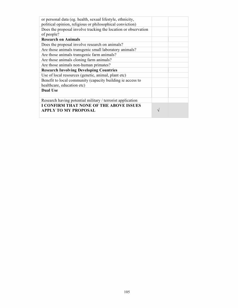
105
or personal data (eg. health, sexual lifestyle, ethnicity, political opinion, religious or philosophical conviction) Does the proposal involve tracking the location or observation of people?
Research on Animals Does the proposal involve research on animals? Are those animals transgenic small laboratory animals? Are those animals transgenic farm animals? Are those animals cloning farm animals? Are those animals non-human primates? Research Involving Developing Countries Use of local resources (genetic, animal, plant etc) Benefit to local community (capacity building ie access to healthcare, education etc)
Dual Use
Research having potential military / terrorist application I CONFIRM THAT NONE OF THE ABOVE ISSUES APPLY TO MY PROPOSAL
√

106
5. Consideration of gender aspects All participant institutions are equal opportunity employers (Articles 2 and 3 of the Treaty of Amsterdam, and COM(98)122 final). It is recognised that women are a key human resource for science in Europe, but that they are still under-represented. In this project, we will implement a series of actions and procedures in accordance with recommended good practices, intended to balance the gender representation within the project and, through the project, within Europe. This has already started during the formulation of the proposal and it should be noted that five out of the ten work-package leaders are female. Indeed, the work-package leader for Education, Dissemination and Outreach is female and this will help to promote a positive image of the role of women in science. Furthermore we will explicitly welcome women in any advertised position and ensure that female participants are aware of current “Family Friendly Laws” that set out regulations for parental leave and pay as well as the right to flexi-time for parents and availability of relevant facilities (eg crèches). Women participants will be encouraged to join women networks linked to the “European Platform of Women Scientists” as it develops. Networking is indeed recognised as an essential tool empowering women scientists in Europe. In its 1999 Communication COM(99)76 “Women and Science: mobilising women to enrich European research:, the Commission recognised that networks of women scientists have a key role to play in ensuring a better integration of the gender dimension in research policy. CoralFISH will gather statistics to show the role of women in the project and their participation in events such as training and project conferences. The project also undertakes to contribute this data to surveys and investigations instigated by the EC.