four creeks state forest · lease/management agreement: # 4507 use: single multiple x management...
TRANSCRIPT

TEN-YEAR RESOURCE MANAGEMENT PLAN
FOR THE
FOUR CREEKS STATE FOREST
NASSAU COUNTY
PREPARED BY
DIVISION OF FORESTRY
FLORIDA DEPARTMENT OF AGRICULTURE AND CONSUMER SERVICES
APPROVED ON
FEBRUARY 19, 2010


FOUR CREEKS STATE FOREST TEN-YEAR RESOURCE MANAGEMENT PLAN
TABLE OF CONTENTS
LAND MANAGEMENT PLAN EXECUTIVE SUMMARY ............................................................ 1 I. INTRODUCTION ............................................................................................................................ 2
A. General Mission, Goals for Florida State Forests, & Management Plan Direction .............. 2 B. Past Accomplishments ................................................................................................................. 3 C. Future Goals and Objectives for the Next Ten-Year Period ................................................... 3
II. ADMINISTRATIVE SECTION ..................................................................................................... 9 A. Descriptive Information ............................................................................................................ 9
1. Common Name of Property .................................................................................................. 9 2. Location, Boundaries, and Improvements ............................................................................. 9 3. Legal Description and Acreage ............................................................................................. 9 4. Degree of Title Interest Held by the Board ...........................................................................10 5. Proximity to Other Public Resources .................................................................................... 10 6. Aquatic Preserve/Area of Critical State Concern .................................................................. 10
B. Acquisition Information ............................................................................................................ 11 1. Land Acquisition Program .................................................................................................... 11 2. Legislative or Executive Constraints ..................................................................................... 11
3. Purpose for Acquisition ......................................................................................................... 11 4. Designated Single or Multiple Use Management .................................................................. 11 5. Alternate Uses Considered .................................................................................................... 12 6. Additional Land Needs .......................................................................................................... 12 7. Adjacent Conflicting Land Uses ........................................................................................... 12 8. Surplus Land Assessment ...................................................................................................... 13
C. Agency and Public Involvement ............................................................................................... 13 1. Responsibilities of Managing Agencies ................................................................................ 13
2. Public and Local Government Involvement .......................................................................... 13 3. Compliance with Comprehensive Plan ................................................................................. 13
III. RESOURCE SECTION ................................................................................................................... 13 A. Past Uses ..................................................................................................................................... 13 B. Renewable and Non-Renewable Resources ............................................................................. 13
1. Soil Types .............................................................................................................................. 13 2. Archaeological and Historical Resources .............................................................................. 143. Water Resources .................................................................................................................... 14 4. Fish and Wildlife ................................................................................................................... 14 5. Endangered and Threatened Species ..................................................................................... 14 6. Beaches and Dunes ................................................................................................................ 15 7. Swamps, Marshes, and Other Wetlands ................................................................................ 15 8. Mineral Resources ................................................................................................................. 169. Unique Natural Features ........................................................................................................ 1 610. Outstanding Native Landscapes ............................................................................................ 16 11. Timber Resource ................................................................................................................... 1 6
IV. MANAGEMENT CONCEPTS BY NATURAL COMMUNITIES AND PROPOSED MANAGEMENT ACTIVITIES ......................................................................................... 17 A. Existing and Planned Uses ........................................................................................................ 17

1. Property Boundaries Establishment and Preservation .......................................................... 17 2. Soil and Water Protection ...................................................................................................... 17
3. Roads and Bridges ................................................................................................................. 18 4. Recreation Management ........................................................................................................ 18
a. Existing Facilities/Infrastructure/Recreational Activities ............................................... 18 b. Planned Recreational Activities ...................................................................................... 19
i. Public Access ........................................................................................................... 19 ii. Parking ..................................................................................................................... 19 iii. Recreational Trails ................................................................................................... 19 iv. Primitive Campgrounds ............................................................................................ 19 v. Canoe/ Boat Launch .................................................................................................20
5. Fire Management ...................................................................................................................20 6. Silvicultural Guidelines & Forest Resource Management Objectives .................................. 21
a. Objectives ....................................................................................................................... 21 b. Silvicultural Operations .................................................................................................. 22 c. Timber Inventory Control ............................................................................................... 22 d. Timber Sales ................................................................................................................... 23
7. Research Projects/Specimen Collection ................................................................................ 23 8. Law Enforcement .................................................................................................................. 24 9. Wildlife and Fish Management ............................................................................................. 24
a. Timber Management ....................................................................................................... 24 b. Prescribed Burning ......................................................................................................... 24 c. Managing Non-Game Species ........................................................................................ 25d. Hunter and Public Access ............................................................................................... 25 e. Food Plots ....................................................................................................................... 2 5f. Law Enforcement ............................................................................................................ 25 g. Future Projects ................................................................................................................ 2 6
10. Non-Native Invasive Species ................................................................................................ 26 11. Insects and Disease and Forest Health .................................................................................. 2612. On-Site Housing .................................................................................................................... 27 13. Utility Corridors and Easements ........................................................................................... 27 14. Ground Disturbing Activities ................................................................................................ 28 15. Apiaries ................................................................................................................................. 2 816. Cattle Grazing........................................................................................................................ 2 817. Ground Cover ....................................................................................................................... 28 18. Restoration ............................................................................................................................ 28
a. Fire .................................................................................................................................. 29 b. Hydrology ....................................................................................................................... 29 c. Species Composition ....................................................................................................... 29d. Adaptive Management Monitoring Area ........................................................................30
B. Description of Natural Communities and Proposed Management Activities .......................30 1. Mesic Flatwoods.................................................................................................................... 31 2. Wet Flatwoods ....................................................................................................................... 32 3. Bottomland Hardwoods ......................................................................................................... 34 4. Estuarine Tidal Marsh ........................................................................................................... 35 5. Floodplain Swamp ................................................................................................................. 36 6. Dome Swamp ........................................................................................................................ 37 7. Mesic Hammock.................................................................................................................... 38 8. Floodplain Marsh .................................................................................................................. 39 9. Hydric Hammock .................................................................................................................. 39 10. Wet Prairie ............................................................................................................................. 40

11. Baygall .................................................................................................................................. 40 C. Impact of Planned Uses on Resources of the Property ............................................................ 41 1. Timber ................................................................................................................................... 41 2. Wildlife .................................................................................................................................. 41
3. Water ..................................................................................................................................... 42 4. Historical/Archaeological ...................................................................................................... 42
V. MANAGEMENT SUMMARY ......................................................................................................... 42 A. Operations Infrastructure .......................................................................................................... 42 B. Management Needs, Priority Schedule and Cost Estimates .................................................. 42 C. Plans to Locate Fragile, Non-Renewable Natural and Cultural Resources ........................ 45
1. Archaeological Resources ...................................................................................................... 45 2. Soil and Water Resources ...................................................................................................... 45 3. Other Resources………… ..................................................................................................... 46
D. Conformation to State Lands Management Plan .................................................................... 46 E. Multiple-Use Potential - Income Producing Activities ........................................................... 46 F. Potential Use of Private Land Managers ................................................................................ 47 VI. REFERENCES ................................................................................................................................. 47

FOUR CREEKS STATE FOREST
TEN-YEAR RESOURCE MANAGEMENT PLAN
EXHIBITS Location Map ........................................................................................................................ Exhibit A Regional Significance Map ................................................................................................... Exhibit B Optimal Boundary Map ........................................................................................................ Exhibit C Management Plan Advisory Group Meeting Summary ........................................................ Exhibit D Compliance with Local Comprehensive Plan ....................................................................... Exhibit E Soil Map and Legend ............................................................................................................ Exhibit F Management Procedures for Archaeological and Historic Sites
and Properties On State-Owned Controlled Lands ......................................................... Exhibit G Wetlands Map ....................................................................................................................... Exhibit H Road Map .............................................................................................................................. Exhibit I Existing and Planned Facilities ............................................................................................. Exhibit J Historical Natural Communities Map ................................................................................... Exhibit K Current Natural Communities Map ....................................................................................... Exhibit L FNAI Rare Species Occurrence Records / Four Creeks SF & Nassau Co. Summary ......... Exhibit M
TABLES
Table 1- Management Accomplishment Summary FY 2004-2009 Four Creeks State Forest .............................................................. Page 3
Table 2- Natural Communities Found on Four Creeks State Forest ..................................... Page 30 Table 3- Estimated Expenditures Organized by Uniform
Cost Accounting Council Categories .................................................................... Page 44
1
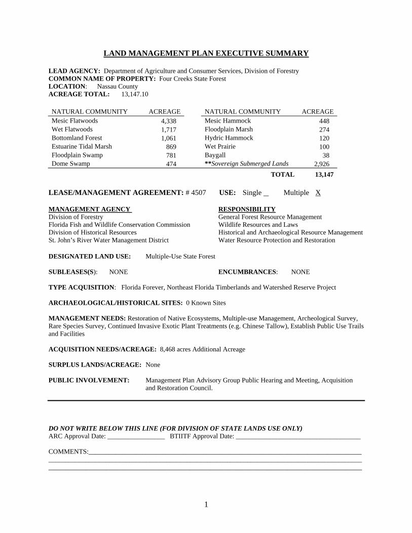
LAND MANAGEMENT PLAN EXECUTIVE SUMMARY LEAD AGENCY: Department of Agriculture and Consumer Services, Division of Forestry COMMON NAME OF PROPERTY: Four Creeks State Forest LOCATION: Nassau County ACREAGE TOTAL: 13,147.10 NATURAL COMMUNITY ACREAGE NATURAL COMMUNITY ACREAGE Mesic Flatwoods 4,338 Mesic Hammock 448 Wet Flatwoods 1,717 Floodplain Marsh 274 Bottomland Forest 1,061 Hydric Hammock 120 Estuarine Tidal Marsh 869 Wet Prairie 100 Floodplain Swamp 781 Baygall 38 Dome Swamp 474 **Sovereign Submerged Lands 2,926
TOTAL 13,147 LEASE/MANAGEMENT AGREEMENT: # 4507 USE: Single Multiple X MANAGEMENT AGENCY RESPONSIBILITY Division of Forestry General Forest Resource Management Florida Fish and Wildlife Conservation Commission Wildlife Resources and Laws Division of Historical Resources Historical and Archaeological Resource Management St. John’s River Water Management District Water Resource Protection and Restoration DESIGNATED LAND USE: Multiple-Use State Forest SUBLEASES(S): NONE ENCUMBRANCES: NONE TYPE ACQUISITION: Florida Forever, Northeast Florida Timberlands and Watershed Reserve Project ARCHAEOLOGICAL/HISTORICAL SITES: 0 Known Sites MANAGEMENT NEEDS: Restoration of Native Ecosystems, Multiple-use Management, Archeological Survey, Rare Species Survey, Continued Invasive Exotic Plant Treatments (e.g. Chinese Tallow), Establish Public Use Trails and Facilities ACQUISITION NEEDS/ACREAGE: 8,468 acres Additional Acreage SURPLUS LANDS/ACREAGE: None PUBLIC INVOLVEMENT: Management Plan Advisory Group Public Hearing and Meeting, Acquisition
and Restoration Council. DO NOT WRITE BELOW THIS LINE (FOR DIVISION OF STATE LANDS USE ONLY) ARC Approval Date: _________________ BTIITF Approval Date: _____________________________________ COMMENTS:___________________________________________________________________________________________________________________________________________________________________________________________________________________________________________________________________________

2
I. INTRODUCTION
Four Creeks State Forest (FCSF) is comprised of 13,147 acres located in south-central Nassau County (Exhibit A). This property was acquired as part of the Northeast Florida Timberlands and Watershed Reserve Project using Florida Forever funds.
FCSF was named after the four water systems that transverse its boundaries. These systems include all or portions of Alligator (Mills), Thomas, Boggy and Plummer Creeks. The four creeks join together to form the headwaters of the Nassau River, which borders the southeastern portion of the property. In addition to the waterways, major natural communities found on the forest include wet flatwoods, mesic flatwoods, floodplain swamp, tidal marsh, strand swamp, dome swamp and baygall. Prior to state ownership the upland communities, which account for approximately 60% of FCSF, were intensely managed for timber production by various industrial forest companies.
A. General Mission, Goals for Florida State Forests, and Management Plan Direction
The primary mission of the Division of Forestry (DOF) in managing FCSF is to protect and manage the unique resources of the forest through a stewardship ethic to assure these resources will be available for future generations. This will be accomplished by implementing sound ecosystem management principles. The goals of which will be to:
• Restore, maintain, and protect all native ecosystems into perpetuity;
• Ensure long-term viability of populations and species considered rare,
endangered, threatened, or of special concern; • Restore, maintain, and protect hydrological functions related to the quality and
quantity of water resources and the health of associated wetland and aquatic natural communities;
• Integrate human use through the multiple-use concept; • Protect known archaeological and historical resources; • Practice sustainable forest management utilizing sound silvicultural techniques.
This management plan is provided according to requirements of Sections 253.034, 259.032 and 373, Florida Statutes, and was prepared utilizing guidelines outlined in Section 18-2.021 of the Florida Administrative Code. This is the initial plan for this state forest. It is not an annual work plan or detailed operational plan but provides general guidance for the management of FCSF for the next ten years and outlines the major concepts that will guide management activities on the forest.
The property was acquired jointly by the St. Johns River Water Management District (SJRWMD) and Board of Trustees of the Internal Improvement Trust Fund using Florida Forever funds on April 27, 2005 from Three Rivers Land LLC, who had previously

3
purchased the property from Rayonier Inc. On November 29, 2007 this lease was amended to include all submerged sovereign lands within and contiguous to the boundaries of FCSF. The major land use of the property up to the time of acquisition had been for intensive silviculture. The majority of the pine plantations are less than 20 years old. The use of prescribed fire by previous landowners was limited to site preparation burns when weather permitted. Previous landowners used silvicultural techniques such as bedding, fertilizer applications, herbicides and timber harvesting to control and manipulate vegetation on the property.
The previous landowners maintained an extensive network of forest roads which reduces the need for future road building projects, but will require regular upkeep and maintenance.
B. Past Accomplishments
FCSF was purchased during the 2004-2005 fiscal year. Since the acquisition, DOF has worked diligently to achieve various accomplishments, including posting boundaries, installing gates, and the implementation of a prescribed burning program. The following is a summary of past accomplishments permitted under the Acquisition and Restoration Council (ARC)/Division of State Lands (DSL) Approved Interim Management Activities.
Table 1. Management Accomplishment Summary FY 2004-2009 Four Creeks State Forest
Program Activity 2004/05 2005/06 2006/07 2007/08 2008/09
Reforestation/ Restoration
Tree Planting (Acres/Species) 0 592/Slash pine*
25/Slash pine* 0 0
Timber Harvest (Thinned) 0 0 773 610 691 Fire
Wildfire (No./Acres) 0/0 0/0 1/12 acres 0 1/4acres
Prescribed Burning (Acres/Month) 0 277/Jan 65/Jan 678/Dec 466/Dec
132/Feb 457/Feb 160/Jan 5/Jan 500/Feb 556/Feb
Total No. Acres Prescribed Burning 0 409 522 1,338 1,027
Boundary Maintenance
Miles Marked or Maintained 14 2 0 1 3 Perimeter Firelines Installed (miles) 0 3 0 0 0
Road Maintenance
Roads Rebuilt/Repaired (miles) 0 0 1 4 2 Culverts Installed/Replaced 0 4 2 1 5
Exotic Species Control Herbicide Chinese Tallow (acres) 0 0 7 72 124
Visitation Day Use (no. visitors/year) 0 0 0 0 3,400 Miscellaneous Gates Installed/Repaired 5 7 0 0 1
*Acreage replanted by Rayonier Inc.
C. Future Goals and Objectives for the Next Ten-Year Period
The following goals and objectives provide direction and focus for management resources for the next 10-year planning period. This section should be used to measure management accomplishments. Funding, agency program priorities and the

4
wildfire/major weather events during the planning period will determine the degree to which these objectives can be met.
GOAL 1: Habitat restoration and improvement
OBJECTIVE 1: The Four Creek State Forest contains approximately 6,200 acres of fire type natural communities. Approximately 1,500 to 3,000 acres will be prescribed burned each year. Due to the large acreage of pre-merchantable pine stands and heavy fuel loading, annual acreage accomplishments may be lower during the first half of this planning period, allowing those stands to mature. (Ongoing- 2 year/10 year)
PERFORMANCE MEASURE: Number of acres burned per year, during the dormant season and growing season. (Acreage should increase as dense plantations are thinned over the ten-year period.)
OBJECTIVE 2: Achieve and maintain 1,500 acres within target fire return interval. (2 year)
PERFORMANCE MEASURE: Number of acres within fire return interval target.
OBJECTIVE 3: Achieve and maintain 3,000 acres within target fire return interval. (10 year)
PERFORMANCE MEASURE: Number of acres within fire return interval target.
OBJECTIVE 4: Develop a fire management plan that addresses the prevention, detection, and suppression of wildfires, and prescribed burning operations. (2 year)
PERFORMANCE MEASURES: Complete FCSF Fire Management Plan and update the plan annually.
OBJECTIVE 5: Develop a plan for the restoration of the FCSF natural communities with emphasis on ground cover. The plan should map areas with remnant ground cover or areas of ground cover that can be recovered with prescribed fire alone and areas where more intensive restoration efforts will be needed, such as reseeding or replanting of native grasses. Develop a plan for the restoration of ground cover in at least one stand identified in the plan where the native ground layer has been heavily impacted from historical land use, including areas that had been previously managed with intensive silvicultural practices. (2 year).
PERFORMANCE MEASURES: Completion of ground cover assessment. Completion of restoration plan.
OBJECTIVE 6: Implementation of ground cover restoration plan. Acreage to be determined as part of assessment identified in Objective 5. Areas identified in the plan as being most likely to be restored with prescribed fire alone will be given highest priority to prevent further degradation. Due to high costs, total acreage treated for areas identified as needing more intensive restoration efforts may be limited by amount of available funding (10 year).

5
PERFORMANCE MEASURE: Total number of acres of areas of intact groundcover burned. Total number of acres with other restoration efforts underway, such as seeding or planting with native grasses or herbaceous groundcover, if planting or seeding is prescribed. Total number of acres treated with prescribed fire in the growing season within the designated ground cover restoration area.
GOAL 2: Public Access and Recreational Opportunities
OBJECTIVE 1: Maintain public access and recreational opportunities, including hunting, to allow for a recreational carrying capacity of approximately 155 visitors per day. (2 year)
PERFORMANCE MEASURE: Number of visitor opportunities/day.
OBJECTIVE 2: Develop additional public access and recreational opportunities to allow for a carrying capacity of approximately 210 visitors/day (10 year).
PERFORMANCE MEASURE: Number of visitor opportunities/day OBJECTIVE 3: Develop and implement a 5-Year Outdoor Recreation Plan and update annually. (2 year/10 year)
PERFORMANCE MEASURE: Completion of the 5-Year Outdoor Recreation and annual updates.
OBJECTIVE 4: Coordinate with surrounding landowners and recreational user groups to promote appropriate recreational opportunities on the forest. (10 year)
PERFORMANCE MEASURE: Number of access points and trail heads installed along boundaries bordering developments, subdivisions, or other public lands.
OBJECTIVE 5: Develop a public information program that includes the development of a FCSF brochure, installation of two informational kiosks, and continue performing three informative programs per year for local schools, groups, and communities. (2 year/10 year)
PERFORMANCE MEASURE: Completion of FCSF brochure, number of kiosks installed, and number of environmental programs completed annually.
OBJECTIVE 6: Within one year of adoption of the ten-year management plan, develop a liaison panel composed of representatives from various user groups to establish communication and seek constructive feedback regarding the management of Four Creeks State Forest. (2 year)
PERFORMANCE MEASURE: Formation of liaison group and hold first meeting.
6
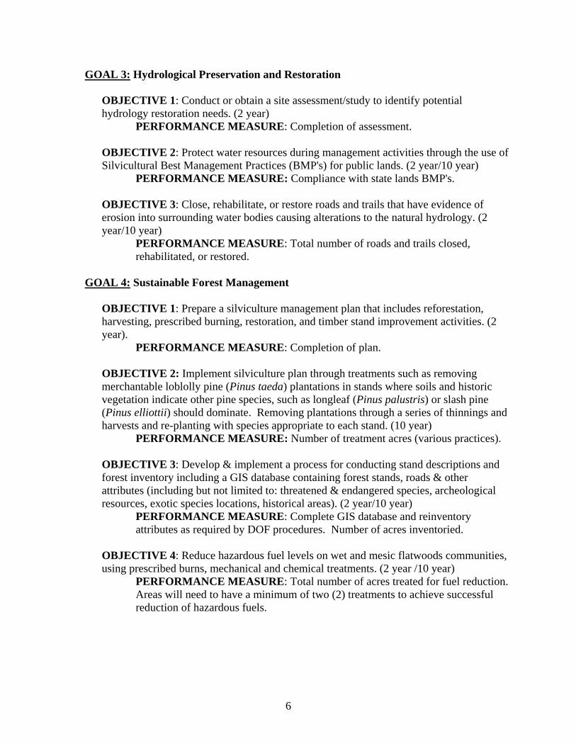
GOAL 3: Hydrological Preservation and Restoration OBJECTIVE 1: Conduct or obtain a site assessment/study to identify potential hydrology restoration needs. (2 year)
PERFORMANCE MEASURE: Completion of assessment. OBJECTIVE 2: Protect water resources during management activities through the use of Silvicultural Best Management Practices (BMP's) for public lands. (2 year/10 year)
PERFORMANCE MEASURE: Compliance with state lands BMP's. OBJECTIVE 3: Close, rehabilitate, or restore roads and trails that have evidence of erosion into surrounding water bodies causing alterations to the natural hydrology. (2 year/10 year)
PERFORMANCE MEASURE: Total number of roads and trails closed, rehabilitated, or restored.
GOAL 4: Sustainable Forest Management
OBJECTIVE 1: Prepare a silviculture management plan that includes reforestation, harvesting, prescribed burning, restoration, and timber stand improvement activities. (2 year).
PERFORMANCE MEASURE: Completion of plan.
OBJECTIVE 2: Implement silviculture plan through treatments such as removing merchantable loblolly pine (Pinus taeda) plantations in stands where soils and historic vegetation indicate other pine species, such as longleaf (Pinus palustris) or slash pine (Pinus elliottii) should dominate. Removing plantations through a series of thinnings and harvests and re-planting with species appropriate to each stand. (10 year)
PERFORMANCE MEASURE: Number of treatment acres (various practices). OBJECTIVE 3: Develop & implement a process for conducting stand descriptions and forest inventory including a GIS database containing forest stands, roads & other attributes (including but not limited to: threatened & endangered species, archeological resources, exotic species locations, historical areas). (2 year/10 year)
PERFORMANCE MEASURE: Complete GIS database and reinventory attributes as required by DOF procedures. Number of acres inventoried.
OBJECTIVE 4: Reduce hazardous fuel levels on wet and mesic flatwoods communities, using prescribed burns, mechanical and chemical treatments. (2 year /10 year)
PERFORMANCE MEASURE: Total number of acres treated for fuel reduction. Areas will need to have a minimum of two (2) treatments to achieve successful reduction of hazardous fuels.
7
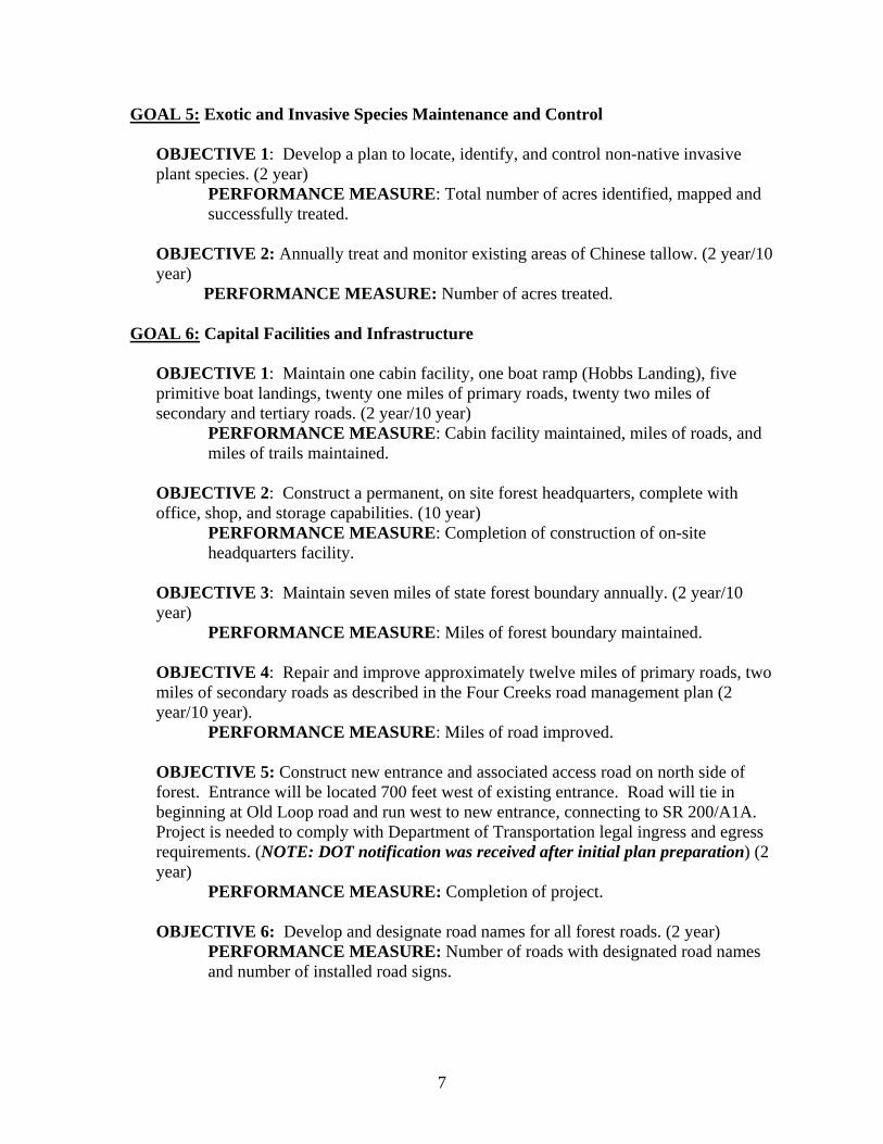
GOAL 5: Exotic and Invasive Species Maintenance and Control OBJECTIVE 1: Develop a plan to locate, identify, and control non-native invasive plant species. (2 year)
PERFORMANCE MEASURE: Total number of acres identified, mapped and successfully treated.
OBJECTIVE 2: Annually treat and monitor existing areas of Chinese tallow. (2 year/10
year) PERFORMANCE MEASURE: Number of acres treated.
GOAL 6: Capital Facilities and Infrastructure
OBJECTIVE 1: Maintain one cabin facility, one boat ramp (Hobbs Landing), five primitive boat landings, twenty one miles of primary roads, twenty two miles of secondary and tertiary roads. (2 year/10 year)
PERFORMANCE MEASURE: Cabin facility maintained, miles of roads, and miles of trails maintained.
OBJECTIVE 2: Construct a permanent, on site forest headquarters, complete with office, shop, and storage capabilities. (10 year)
PERFORMANCE MEASURE: Completion of construction of on-site headquarters facility.
OBJECTIVE 3: Maintain seven miles of state forest boundary annually. (2 year/10 year)
PERFORMANCE MEASURE: Miles of forest boundary maintained. OBJECTIVE 4: Repair and improve approximately twelve miles of primary roads, two miles of secondary roads as described in the Four Creeks road management plan (2 year/10 year).
PERFORMANCE MEASURE: Miles of road improved. OBJECTIVE 5: Construct new entrance and associated access road on north side of
forest. Entrance will be located 700 feet west of existing entrance. Road will tie in beginning at Old Loop road and run west to new entrance, connecting to SR 200/A1A. Project is needed to comply with Department of Transportation legal ingress and egress requirements. (NOTE: DOT notification was received after initial plan preparation) (2 year)
PERFORMANCE MEASURE: Completion of project. OBJECTIVE 6: Develop and designate road names for all forest roads. (2 year)
PERFORMANCE MEASURE: Number of roads with designated road names and number of installed road signs.
8
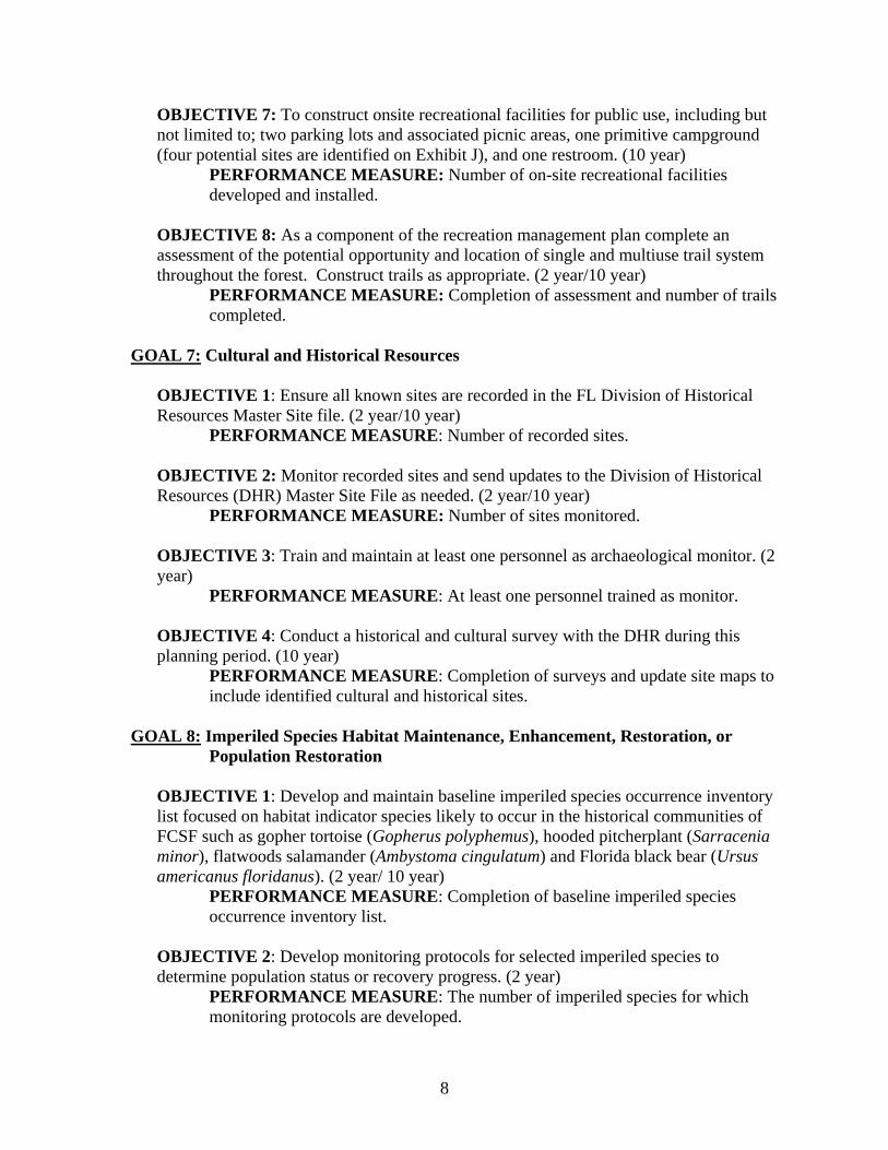
OBJECTIVE 7: To construct onsite recreational facilities for public use, including but not limited to; two parking lots and associated picnic areas, one primitive campground (four potential sites are identified on Exhibit J), and one restroom. (10 year)
PERFORMANCE MEASURE: Number of on-site recreational facilities developed and installed.
OBJECTIVE 8: As a component of the recreation management plan complete an assessment of the potential opportunity and location of single and multiuse trail system throughout the forest. Construct trails as appropriate. (2 year/10 year)
PERFORMANCE MEASURE: Completion of assessment and number of trails completed.
GOAL 7: Cultural and Historical Resources
OBJECTIVE 1: Ensure all known sites are recorded in the FL Division of Historical Resources Master Site file. (2 year/10 year)
PERFORMANCE MEASURE: Number of recorded sites. OBJECTIVE 2: Monitor recorded sites and send updates to the Division of Historical Resources (DHR) Master Site File as needed. (2 year/10 year)
PERFORMANCE MEASURE: Number of sites monitored. OBJECTIVE 3: Train and maintain at least one personnel as archaeological monitor. (2 year)
PERFORMANCE MEASURE: At least one personnel trained as monitor. OBJECTIVE 4: Conduct a historical and cultural survey with the DHR during this planning period. (10 year)
PERFORMANCE MEASURE: Completion of surveys and update site maps to include identified cultural and historical sites.
GOAL 8: Imperiled Species Habitat Maintenance, Enhancement, Restoration, or
Population Restoration OBJECTIVE 1: Develop and maintain baseline imperiled species occurrence inventory list focused on habitat indicator species likely to occur in the historical communities of FCSF such as gopher tortoise (Gopherus polyphemus), hooded pitcherplant (Sarracenia minor), flatwoods salamander (Ambystoma cingulatum) and Florida black bear (Ursus americanus floridanus). (2 year/ 10 year)
PERFORMANCE MEASURE: Completion of baseline imperiled species occurrence inventory list.
OBJECTIVE 2: Develop monitoring protocols for selected imperiled species to determine population status or recovery progress. (2 year)
PERFORMANCE MEASURE: The number of imperiled species for which monitoring protocols are developed.

9
OBJECTIVE 3: Implement monitoring protocols for imperiled species. (2 year/10 year)
PERFORMANCE MEASURE: The number of species for which monitoring is ongoing.
OBJECTIVE 4: In cooperation with FWC, develop a Wildlife Management Plan that addresses all appropriate fish and wildlife species, including appropriate imperiled species, their habitats, and their sustainability based on site-specific population data. In conjunction with this plan, institute a continuous monitoring program to ensure the viability of these populations. (10 year)
PERFORMANCE MEASURE: Completion of the wildlife management plan.
OBJECTIVE 5: Revise the current map of ecological communities to include information on rare species diversity, such as high quality hardwood swamps, high quality flatwoods, ephemeral wetlands, rookeries, nests, etc using data from the 2007 Florida Natural Areas Inventory (FNAI) survey. (2 year) PERFORMANCE MEASURE: Completion of the revised map.
OBJECTIVE 6: Protect environmentally sensitive communities such as wetlands and ecotones when carrying out forest management activities. (2 year/10year)
PERFORMANCE MEASURE: Map environmentally sensitive areas. Number of staff trained in protection of sensitive areas.
II. ADMINISTRATIVE SECTION
A. Descriptive Information
1. Common Name of Property The common name of the property is Four Creeks State Forest (FCSF).
2. Location, Boundaries, and Improvements FCSF is located in south-central Nassau County, approximately one mile east of Callahan, Florida. Forest boundaries are identified on the attached map (Exhibit A). Two structures, a small wooden hunting cabin with electricity and one small wood shed without electricity, exist on the property.
3. Legal Description and Acreage
FCSF is 10,221 acres. The property is located in all or part of Sections 7-9, 13-14, 27, 28, 40-43, 45, Township 02 North, Range 26 East; and Sections 13-15, 22-24, 27, 37, 43, 44, 46-52, Township 02 North, Range 25 East, Nassau County, Florida.
PARCEL NAME DEED DATE
FUNDING SOURCE COUNTY ACRES
Sovereign Submerged ---- ---- NASSAU 2,926 E FL Timberlands 4/25/2005 FL FOREVER NASSAU 10,221.10
10
4. Degree of Title Interest Held by the Board The Board of Trustees of the Internal Improvement Trust Fund and St John’s River Water Management District (SJRWMD) each hold 50% of the 10,221.10 acres of FCSF (lease agreement #4507). Pursuant to section 259.032(9)(e), F.S., staff recommends that the Board of Trustees designate the Department of Agriculture and Consumer Service’s Division of Forestry as the managing agency for this site. In November of 2007, the lease agreement was amended to include 2,926 acres of sovereign submerged lands contiguous with the existing boundary bringing the total acreage to 13,147. The lease agreement can be viewed at the offices of the Department of Environmental Protection (DEP), Division of State Lands and FCSF Headquarters. The acquisition of this property was funded with monies from SJRWMD and DEP’s Florida Forever Program.
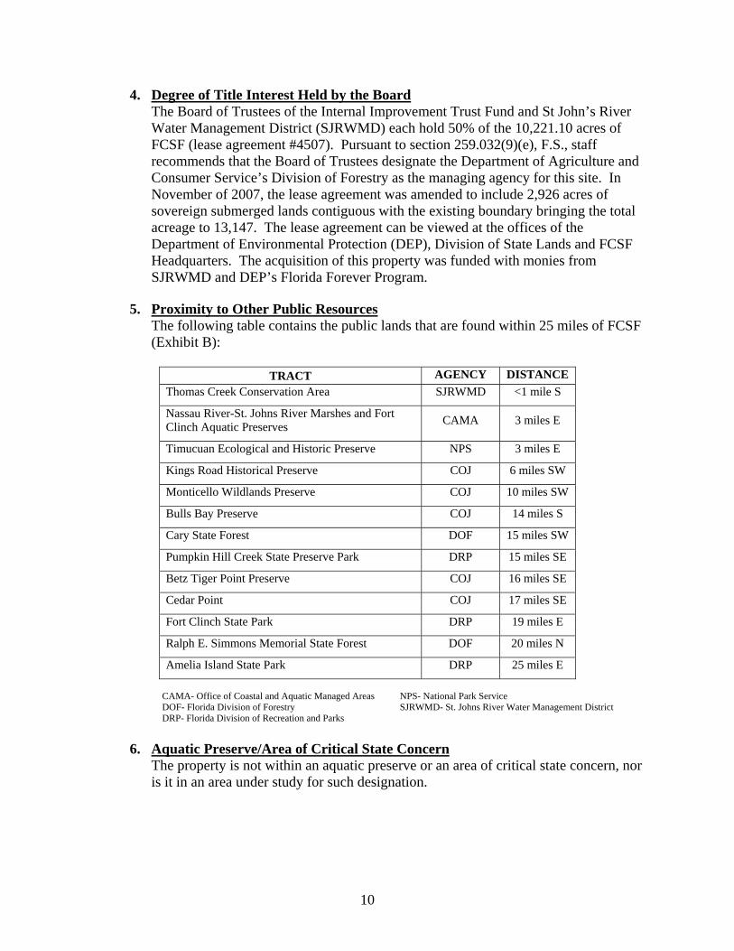
5. Proximity to Other Public Resources The following table contains the public lands that are found within 25 miles of FCSF (Exhibit B):
TRACT AGENCY DISTANCE
Thomas Creek Conservation Area SJRWMD <1 mile S
Nassau River-St. Johns River Marshes and Fort Clinch Aquatic Preserves CAMA 3 miles E
Timucuan Ecological and Historic Preserve NPS 3 miles E
Kings Road Historical Preserve COJ 6 miles SW
Monticello Wildlands Preserve COJ 10 miles SW
Bulls Bay Preserve COJ 14 miles S
Cary State Forest DOF 15 miles SW
Pumpkin Hill Creek State Preserve Park DRP 15 miles SE
Betz Tiger Point Preserve COJ 16 miles SE
Cedar Point COJ 17 miles SE
Fort Clinch State Park DRP 19 miles E
Ralph E. Simmons Memorial State Forest DOF 20 miles N
Amelia Island State Park DRP 25 miles E CAMA- Office of Coastal and Aquatic Managed Areas NPS- National Park Service DOF- Florida Division of Forestry SJRWMD- St. Johns River Water Management District DRP- Florida Division of Recreation and Parks
6. Aquatic Preserve/Area of Critical State Concern
The property is not within an aquatic preserve or an area of critical state concern, nor is it in an area under study for such designation.

11
B. Acquisition Information
1. Land Acquisition Program FCSF was purchased under the Northeast Florida Timberlands and Watershed Reserve Project using Florida Forever funds.
2. Legislative or Executive Constraints
There are no known legislative or executive restraints on the forest. As part of the acquisition of FCSF, a timber agreement made between Rayonier, SJRWMD, and DEP, states that Rayonier maintained the harvesting rights to approximately 1,006 acres of timber for three years. These areas were clear-cut, raked, bedded and replanted with slash pine by Rayonier. Reforestation of these areas concluded in the spring of 2007.
3. Purpose for Acquisition
The main objectives for the acquisition of this property are:
• To conserve and protect, through sustainable forest management practices, environmentally unique and irreplaceable lands that contains native flora and fauna that represent a natural area unique to, or scarce within, a region of this state or a larger geographical area.
• To conserve and protect native species habitat and endangered and threatened species.
• To conserve, protect, manage, or restore important ecosystems, landscapes, and forests, if the protection and conservation of such lands is necessary to enhance or protect significant surface water, ground water, coastal, recreational, and timber resources, or to protect fish or wildlife resources which cannot otherwise be accomplished through local and state regulatory programs.
• To provide amenities that support natural resource-based recreation. • To preserve archaeological or historical sites.
4. Designated Single or Multiple Use Management
FCSF is designated for multiple-use management with the DOF as the lead agency as stated in Multiple Agency Lease Agreement #4507. Authority for multiple-use management is given under Chapters 253 and 589, Florida Statutes. Sustainable multiple-use management is the overall goal for the property. Multiple-use management includes, but is not limited to, the following activities: silvicultural management, recreation, wildlife management, archaeological and cultural resource management, ecosystem restoration, environmental education, and watershed management. The goals of the DOF are to protect and manage ecosystems, restore and maintain biological diversity, and integrate public use through multiple-use of the forest resources. Multiple-use resource management and the practice of sustainable forestry will provide for the greatest public benefit in perpetuity, while at the same time protecting all the values and resources of the land. Local demands and geographic factors influence the array of uses to be applied to any area of the forest.
12
Only uses compatible with the forest and its ecosystems will be implemented. Forest management practices should ensure that all resources of the forest are sustained for the future. Sustainable forest management will be practiced to ensure long-term forest health.
5. Alternate Uses Considered
No alternate uses are being considered at this time. Other uses will be considered as requests are made and will be accommodated as appropriate, if they are determined to be compatible with other uses and with the management goals and objectives of the forest. The following uses were considered and determined not compatible: water resource development projects, water supply development projects, storm-water management projects, linear facilities, communication towers and antennas, except as otherwise outlined in this plan.
6. Additional Land Needs There are several parcels of land adjacent to and within FCSF boundaries that should be considered for acquisition. The DOF will work with property owners, on a willing seller basis, in an effort to acquire these parcels. Parcels located adjacent to forest boundaries that should be considered for acquisition include the Stoddard Tract located along Boggy Creek and the Stokes Tract located at the southeastern edge of the forest. Additional properties to review for acquisition which are adjacent to the forest include: the Rayonier Tract to the north that contains the north branches of Boggy and Plummer Creeks (also a portion of the Nassau Wildlife Management Area) as well as several smaller parcels of land adjacent to the forest that are held be several landowners. Furthermore, procurement of lands located to the south of FCSF on the southern side of Thomas Creek would also aid in protecting natural resources in this area. Any acquisition, within the optimal management boundary (Exhibit C) would facilitate restoration, protection, maintenance, and management of the natural resources on FCSF as well as improve public access to the forest.
7. Adjacent Conflicting Land Uses During the development of this management plan, DOF staff identified and evaluated adjacent land uses; reviewed current comprehensive plans and future land use maps in making the determination that there are currently no known conflicting adjacent land uses. Additionally, DOF staff met with adjacent land owners and maintains liaison with those land owners to ensure that any conflicting future land uses may be readily identified and addressed.
We welcome the opportunity to meet with any adjacent property owner(s), prospective owner(s), or prospective developer(s) to discuss methods to minimize negative impacts on management, resources, facilities, roads, recreation, etc. We also look forward to hearing/sharing ideas on how the property owner(s)/developer(s) may develop the property adjacent to the shared property line, and perhaps provide buffers to minimize encroachment into the forest and to reduce any management impacts.

13
8. Surplus Land Assessment All of the property within the current boundaries of FCSF is important for management and none should be declared surplus.
C. Agency and Public Involvement
1. Responsibilities of Managing Agencies
The Florida Department of Agriculture and Consumer Services, DOF is responsible for the overall management of the forest. The Florida Fish and Wildlife Conservation Commission (FWC) will assist the DOF in providing technical advice on the management of wildlife populations (game and non-game), setting hunting seasons, establishing bag limits, and enforcing rules and regulations related to the management of the wildlife resources. The DHR cooperates with the DOF regarding appropriate management practices on historical or archaeological sites on the forest as stated in Section 267.061(2) (d), Florida Statutes.
2. Public and Local Government Involvement This plan was prepared with input from the FCSF Management Plan Advisory group. They conducted a public hearing on October 28th, 2009 and held a public meeting on October 29th, 2009 to review the draft plan, submit comments and suggestions to DOF staff (Exhibit D). The Acquisition and Restoration Council (ARC) public hearing and public meeting serve as an additional forum for public input and review. The DOF also responds to public involvement through communication with individuals, user groups, and government officials. This forest has not been subject to a Land Management Review.
3. Compliance with Comprehensive Plan This plan was submitted to the Board of County Commissioners of Nassau County for review of compliance with their local comprehensive plans (Exhibit E).
III. RESOURCE SECTION
A. Past Uses FCSF was primarily managed for timber production through the majority of the last
century. In addition to timber production, the forest was also used for turpentine production. Hunting, fishing, and water-based recreation were also common uses of the property.
B. Renewable and Non-Renewable Resources
1. Soil Types
The dominant soils present on FCSF are the Chaires fine sand series and Goldhead fine sand series. The Goldhead series is found in slightly lower elevations and sloughs. Both series consist of nearly level, poorly drained soils. Additional soils series present on FCSF include the Buccaneer clay series and the Croatan muck.

14
These soils are the dominant series in the wetland communities. See Exhibit F for soils information from the USDA Soil Survey of Nassau County, Florida.
2. Archaeological and Historical Resources The Bureau of Archaeological Research will conduct an Assessment of Cultural Resources on FCSF within this ten year planning period. The DOF will comply with guidelines outlined in “Management Procedures for Archaeological and Historical Sites and Properties on State-Owned or Controlled Lands” (Exhibit G), which will protect known archaeological and historical sites, and will also utilize the expertise of the DHR Public Lands Archaeologists for detecting unknown resources.
3. Water Resources There are four main waterways that flow through FCSF that form a network of
navigable waterways. Thomas Creek forms the southern boundary of the forest and serves as the county divide between Nassau and Duval counties. Alligator Creek is a manmade canal that flows for one and a half miles across the forest before turning into Mills Creek. Mills Creek then flows for approximately two before joining with Boggy Creek. Boggy Creek flows in from the north for about two miles before forming the headwaters of the Nassau River. A third system, Plummer Creek, also flows into the Nassau River. Thomas Creek also joins with the Nassau River, which then flows east to the Atlantic Ocean. All the creeks are navigable by small water craft. Thomas, Mills, Plummer, and Boggy Creek are all considered to be a mix of freshwater and brackish systems. All water bodies on FCSF are classified as Class III Surface Waters-Recreation, Propagation, and Maintenance of a Healthy Well-balanced Population of Fish and Wildlife in accordance with Rule 62-302.400, Florida Administrative Code.
4. Fish and Wildlife Management of FCSF will focus on the development of biological diversity and
species composition. These goals will be accomplished through proven land management techniques, such as prescribed fire, pine thinnings, etc. All biological resources will be managed to maintain and enhance diversity. During this 10-year planning period, a list of species observed on FCSF will be compiled.
5. Endangered and Threatened Species At this time, several rare or threatened species have been observed on FCSF. These
include the American alligator (Alligator mississippiensis), gopher tortoise (Gopherus polyphemus), and painted bunting (Passerina ciris), blueflower butterwort (Pinguicula caerulea) and hooded pitcherplant (Sarracenia minor). These were identified in the field during a 2007 FNAI natural communities survey (Exhibit M). It is possible that due to its size and proximity to other forested areas, FCSF may act as a corridor for such species as Florida black bear. Also in Exhibit M is an FNAI list of rare species documented and reported as occurring in Nassau County and which might be expected to occur in FCSF. A rare species survey should be conducted within this ten-year period to determine population data for species previously

15
observed and evaluate if other rare or threatened species, such Florida black bear, may occur as well.
6. Beaches and Dunes There are no beaches or dune systems on FCSF. 7. Swamps, Marshes, and Other Wetlands In addition to the waterways, FCSF contains nine historical wetland communities,
listed in the following table. These communities were delineated from aerial photographs during the FNAI survey.
FNAI Communities Current Acreage
Bottomland Forest 1,131 Floodplain Swamp 981 Estuarine Tidal Marsh 802 Dome Swamp 320 Hydric Hammock 140 Baygall 38 Wet Flatwoods 36 Floodplain Marsh 13 Wet Prairie 2
TOTAL 3,463
An assessment should take place over the course of this ten-year planning period to confirm that the proper natural communities were assigned, verify acreage, and examine the effects of forest management activities, including prescribed fire on baygalls and seepage slopes. The preliminary wetland delineations for this project are shown in Exhibit H.
The water resources on FCSF perform essential roles in the protection of water
quality, groundwater recharge, flood control and aquatic habitat preservation. In the interest of maintaining these valuable resource functions, state forest management personnel will work with the DOF Hydrology Section to incorporate wetland restoration into the overall resource management program. Emphasis will be placed on wetland systems that have been impaired or negatively impacted by previous management activities or natural disasters.
Wetland restoration objectives on the forest include erosion control, restoration of
hydrology and/or hydro-period and restoration of wetland plant and animal communities. To achieve these objectives, restoration activities may involve road and soil stabilization, water level control structure removal or installation, exotic species control, site preparation and re-vegetation with native wetland species, and project monitoring. These activities will be implemented by DOF personnel, non-DOF personnel or grant contractual agreements. Where practical wetland restoration

16
projects should be conducted in conjunction with other restoration activities indicated elsewhere in this plan.
To the extent possible, FCSF staff, with assistance from the Division’s Hydrology Section staff, will develop a list of specific wetland restoration projects in order to facilitate the process of procuring funding for restoration projects. In addition, cooperative research among the DOF, other state agencies, and the federal government will provide valuable information in determining future management objectives of wetland restoration.
8. Mineral Resources No mineral resources are known to exist on this property. 9. Unique Natural Features Thomas Creek, Alligator Creek, Mills Creek, and Plummer Swamp Creek merge at
the east end of the forest to form the Nassau River. This complex system of creeks on FCSF is considered to be a unique natural feature.
10. Outstanding Native Landscapes The creek systems on FCSF drain into nearly intact bottomland hardwood
communities. These areas are considered to be outstanding native landscapes and provide necessary forging areas for wildlife.
11. Timber Resource The DOF will implement silvicultural practices, including harvesting, prescribed
burning, and reforestation, in order to establish a healthy forest with an age distribution that best duplicates natural systems. Well-timed and executed timber harvests play an integral role in the health of forest ecosystems. Thinning dense forest stands improves understory habitat and allows for a more natural regime. Timber harvesting is also used in re-establishing native species by creating an opening for either artificial or natural regeneration of desired species. Of the total non-submerged acreage on FCSF (10,221), approximately 60 percent is in planted pines (6,280 acres), ranging in age from 1 year to 24 years old. Approximately 3,560 acres are planted in slash pine and 2,720 acres are planted in loblolly pine. Good stewardship and resource sustainability are essential goals for any proposed silvicultural activity and will guide all management decisions regarding the timber resources on FCSF. The management of the timber resources will not seek to maximize short-term economic revenue, but rather to achieve a wide array of long-term public benefits.
The DOF practices sustainable timber management in the state forest system, which
means annual harvest volume on each state forest will not exceed the annual growth rate. This is accomplished by periodically obtaining accurate estimates of standing timber volumes in order to ensure that the timber resource will not be depleted.
Currently, the timber inventory program is on a ten-year cycle, with 10 percent of the land base inventoried annually, resulting in a stand being inventoried once every ten

17
years. In addition, any timber stands that are thinned will be re-inventoried once the harvesting operation is complete. This inventory information will be an aid in determining growth rates, stocking information and assist with short and long-term resource planning. Initial inventory data for FCSF will be based upon field assessments as well as information obtained from the acquisition timber cruise and timber appraisal. This information will be used to develop stand maps as well as determine initial timber stand information (i.e. stocking density, products, etc). This information will be used to assess the current timber resource and develop sustainable timber harvesting plans as well as monitor forest health. Initial inventory data collection for every stand is scheduled to be completed during the fiscal year 2009-2010. Upon completion of the initial inventory, FCSF managers will then assume the ten-year inventory update cycle.
IV. MANAGEMENT CONCEPTS BY NATURAL COMMUNITIES AND PROPOSED MANAGEMENT ACTIVITIES
A. Existing and Planned Uses
The tract will be managed under the multiple-use concept. As previously stated, Florida Statutes describe the general management philosophy on public land; specifically Florida Forever lands, in order to achieve the greatest combination of benefits to the people of the state. Activities to occur on FCSF will include: forest resource management; restoration, maintenance, and protection of all native ecosystems; integration of appropriate human uses; and insuring long-term viability of populations and species considered endangered, threatened, or of special concern. Activities that will be integrated into these goals include: timber management, recreation management, wildlife management, and watershed management.
1. Property Boundary Establishment and Preservation Approximately 95 percent of the forest boundary has been established and marked
with signage, except along wetland boundaries. The remaining area to be posted is along Thomas Creek, was completed in 2008.
2. Soil and Water Protection
The acquisition and management of public land often has several objectives, including maximizing ecological restoration, protecting and managing existing natural resources and facilitating optimum public use. Concern over water quality in North Florida requires that emphasis be placed on protecting FCSF water resources. The creek systems are not the only water resources on FCSF. There are also numerous flatwoods ponds, floodplain swamps, and cypress domes scattered throughout the forest. These wetland areas are not conducive to recreation development; however they do provide vital habitat for numerous wildlife species as well as flood protection to surrounding areas.

18
To prevent soil erosion and to protect water resources on the forest, all management activities will strictly adhere to the current Silviculture BMP manual. Copies of this publication are available upon request from the DOF Forest Hydrology Section.
3. Roads and Bridges FCSF has an extensive network of roads. There is public access on the northern and
southwestern sides of the property (Exhibit I). Pacetti Road provides access to the southern edge of the property while A1A/S.R. 200 runs along the northern edge of the forest.
Interior forest roads are composed of sand or clay and have a variety of
classifications. They are relatively intact; however several roads along the southern half of the forest are currently closed to administrative access due to hazardous conditions. Closed roads are clearly marked road closed signs. These roads will need to be repaired prior to opening for public use. A five year road plan for FCSF was completed in 2008. This plan will include a complete road assessment, road naming system, and plans for rehabilitation, closure or construction of roads. Plans for the establishment of new roads will be reviewed by the DOF, DHR, FNAI, and ARC.
4. Recreation Management The demand for resource-based outdoor recreation within the Nassau County area
will continue to grow as urbanized growth increases in the nearby cities of Callahan, Yulee, and Jacksonville. Due to the increased population and proximity to a major inter-state highway (I-95), FCSF will be in a position to provide unique recreational experiences to numerous citizens and visitors of Florida. The primary recreation objective on FCSF will be to provide visitors with quality outdoor recreational opportunities that are dependent on the natural environment. Recreational activities may include, but are not limited to, hiking, hunting, fishing, canoeing, kayaking, nature study, bicycling, horseback riding, and primitive camping. a. Existing Facilities/Infrastructure/Recreational Activities There is a small cabin located on the northern half of the property. It is a former
hunting cabin with electricity and plumbing. This facility may serve as a small meeting room as well as provide space for educational materials such as pamphlets and exhibits regarding Florida’s natural heritage as well as other educational elements. In addition, this cabin may be used as a special use area for small group camping. The need for, and construction of, additional facilities will be examined by DOF staff. If a need is determined, requests will be submitted through the proper channels at that time.
In addition to the cabin, there is an old hunt camp on the southern side of the
forest that could be used as a camping and/or picnic area. Public access to this site will need to be addressed prior to determining its use. Existing roads and fire lines surrounding the site could also be used for a trail system.

19
There are two main entrances to FCSF, on the north side of the forest located off of A1A and the Pacetti Road entrance on the south side of the property.
There is currently one concrete boat landing located along Mills Creek on the
southern portion of the property. This area could provide space for primitive camping as well as a canoe launch site. It is possible to launch small motorized boats from this landing. Forest roads leading into and out of the area would need to be assessed to determine the level of traffic they can safely accommodate. There are five unimproved landings located on FCSF (See Exhibit J for a map of unimproved boat ramps). These areas are also suitable for primitive camping and/or canoe outposts. The DOF will work in cooperation with FWC to ensure all rules and regulations regarding navigable waterways are enforced. In addition, the DOF would need to assess the need for and develop a plan for fee assessment and collection. See Exhibit J for a map of all existing facilities.
b. Planned Recreational Activities
i. Public Access Public access to the southern half of the forest is currently through
Pacetti Road. The north half of the forest is accessible from S.R. A1A. Forest roads are generally in good condition but need improvement to facilitate public access. Entrances and some roads will have to be widened to allow two-way traffic. Public ingress/egress should be limited to a few designated sites to limit disturbance and to increase safety. Public access points will be developed with input from user groups and other interested members of the general public.
ii. Parking Sites for parking areas will be determined as the need arises. Areas
should be large and stable enough to allow easy maneuvering by large vehicles such as fire control transports and horse trailers. These areas should also be assessed for the need of additional amenities such as picnic tables and garbage cans.
iii. Recreational Trails As previously stated, forest roads and firelines are available for
conversion into recreational trails. In addition, forest managers will focus on assessing the need for additional trails and possible routes that will highlight FCSF natural attributes in this 10-year planning period. Trails will be designated and developed with user-group input to the greatest extent possible.
iv. Primitive Campgrounds At least five sites have been identified for the creation of primitive
campsites. Other sites will be examined for suitability as well.

20
Proposals for at least one primitive camping area should be initiated within this planning period.
v. Canoe/Boat Launch As mentioned above, FCSF currently contains one boat ramp and five
primitive landings. Canoe trails and maps should be developed to provide recreational users the opportunity to experience FCSF unique water resources.
5. Fire Management The DOF utilizes a total fire management program on state forests that includes
wildfire prevention, detection, suppression, and prescribed burning. Primary detection and suppression of wildfires are the responsibility of the DOF under the direction of the Jacksonville District (District -7); particularly forest rangers assigned to the Hilliard Work Center and Yulee and Tisonia tower sites. Nassau County has four tractor-plow units; two stationed at Hilliard Work Center, and one each at the Yulee and Tisonia sites. To help reduce wildfire occurrence on FCSF, emphasis will be placed on prescribed burning, fire prevention, and education. The Incident Commander responding to wildfires on FCSF has three paramount considerations, listed in order of priority: protection of human lives, including the public and the firefighters, protection of improvements, and protection of natural resources.
The FCSF prescribed burning program produces multiple benefits and is considered
to be one of the primary management tools used on the forest. The purpose of prescribed burning on FCSF is to reduce dangerous wildland fuel loadings and restore, maintain, and protect in perpetuity all native ecosystems, ecotones, and their ecological processes.
Except for site preparation burns, prescribed fire has been absent from the FCSF
landscape for at least the last decade. This lack of fire has resulted in heavy fuel loads within both merchantable and pre-merchantable pine plantations.
Burn units that have had at least two prescribed burns will be considered in the
maintenance phase and will be concentrated on more than areas that have not been burned. This is to ensure that progress in those units will not be lost in the interim. With an average two to four year fire return interval over approximately 6,200 acres of uplands, the goal is to burn 1,500 to 2,100 acres annually. However, given the amount of pre-merchantable stands mentioned above, average annual acreage burned per year may be lower during the first half of this planning period, allowing those stands to mature.
As fuel loads are reduced, burn units may be combined, reducing the number of
interior lines and ultimately improving hydrologic functions and ecosystem processes. Natural firebreaks should be used whenever possible to reduce disturbance in transition areas. Aerial ignition should be considered as a viable firing technique in hydric areas. This practice will help achieve the goal of burning across transitions to maintain ecotones and reduce hardwood encroachment. These hydric areas

21
periodically will burn naturally. Due to the lack of a prescribed fire regime the duff layers may be abnormally thick. If these areas are burned when dry, timber losses and smoke problems may outweigh the restoration benefits.
In using prescribed fire in the various pyric communities on this forest, it is important
to understand the ecological richness of the ecotones that divide them - especially those margins between wetland and upland communities. Every effort will be made to avoid the construction and/or maintenance of fire lines in these environmentally sensitive areas. The biological diversity of these ecotones will benefit from prescribed fire being allowed to burn uninterrupted into the edges of the adjacent hydric communities. In this manner fire also serves to limit the invasion of less fire-adapted, hydric species (e.g. loblolly-bay) into the adjacent, more mesic communities.
Wetland communities, such as fresh water marshes and seasonal ponds, benefit from
occasional fire which serves to limit peat accumulation and invasion of woody vegetation and helps to prevent undesired transition to plant species associated with more mesic conditions. In addition, moderately intense fire in swamps can benefit cypress and retard invasion of less fire-adapted hardwood species. Where these wetland communities are not sufficiently hydrated to prevent undesirable fire intensity and smoke management problems, consideration will be given to delaying prescribed fire. When proceeding with burning in these conditions, and fire lines are required, these exclusion lines should be located well out of the ecotone up in the more mesic community type. These exclusion lines will be used only in areas highly susceptible to muck fires. Pre-suppression or prescribed fire control lines should avoid, at all costs, sensitive seepage slopes adjacent to swamps and in any other area that would disrupt the natural hydrology or areas of sensitive plants (e.g. hooded pitcherplants)
To determine the effects of the fire management program, good monitoring is needed.
Monitoring should include pre and post-burn evaluations. In addition, establishing a series of photo points and permanent vegetation plots will increase the effectiveness of the monitoring process. Some indices of the effectiveness of burns are percent needle scorch, amount of timber mortality, percent fuel consumed, percent stem char, and no net loss of the organic layer. Forestry field staff will evaluate the effects of the burning program.
Established perimeter and interior firebreaks will be used when possible. Additional
firebreaks will be installed to ensure safe burning conditions when and where deemed appropriate by staff. Placement of new firebreaks will be carefully reviewed by field staff and will be developed so as to avoid sensitive areas. A five year fire management plan will be completed in 2010.
6. Silvicultural Guidelines and Forest Resource Management Objectives
a. Objectives The objectives of these silvicultural management guidelines are:

22
i. To restore health and vigor to the forest ecosystem through prescribed burning
and through reforestation, both naturally and artificially with species native to the site, including longleaf, slash, and loblolly pine.
ii. To maintain the forest over the long-term through natural regeneration,
uneven-aged and even-aged management.
iii. To create a naturally regenerating forest with old growth characteristics that provides sustainable economic, ecological, and social benefits while managing for ecological restoration.
b. Silvicultural Operations Detailed silvicultural prescriptions will be developed at the stand level outlining
the proper species for the stand based upon soils and historic vegetation. For reforestation activities the preferred method of site preparation will be
prescribed fire. To address vegetative competition it may be necessary to utilize chemical and mechanical methods in conjunction with prescribed fire. Initially, for artificial stand establishment, even-aged management will be employed. Through a series of timed thinnings of these slash and loblolly pine stands will be carried for a rotation of sixty to eighty years. Eventually, stand structure will be converted to a mixture of even-aged and uneven-aged management by utilizing natural regeneration methods, where appropriate. In stands where uneven aged management is not appropriate, even-aged management will continue.
Thinning, group selection, shelterwood, and clear-cutting will all be necessary to
ensure proper maintenance and overall health of timber stands and communities. A detailed five-year timber resource plan will be completed that will outline specific silvicultural treatments for each timber stand.
c. Timber Inventory Control
An acquisition timber cruise and timber appraisal was completed, in November 2003, by the consulting firm Jowett and Wood, Inc. Their survey gives a total merchantable pine forest volume of approximately 14,977 tons of pine pulpwood, 18,325 tons of pine chip-n-saw, 10,338 tons of pine saw timber, and 339 tons of pine poles located on 1,637 acres. Approximately 6,146 acres of pre-merchantable pine plantations were not assigned volumes. Hardwood volumes were also computed in the pre-sale cruise. Approximately 1,497 acres of the 1,637 acres of merchantable pine is classified as natural pine-hardwood areas. Total merchantable hardwood forest volume is approximately 72,311 tons of hardwood pulpwood, 13,566 tons of hardwood saw timber, 4,227 tons of cypress mulch, and 3,199 tons of cypress saw timber.

23
Initial stand delineation has been completed for FCSF. An initial total of 156 stands have been delineated within the forest boundaries. All stand numbers and information in this plan reflect the new stand delineation. Volume information is based upon the pre-acquisition timber cruise and timber appraisal. As inventory data is collected and updated, stand delineations may change. All stands will be re-inventoried within the first year after the approval of this plan. Once the initial cruise is completed, portions of the forest will be re-inventoried each year, with each stand re-inventoried at least once every ten years. Upon completion of the initial inventory, stands may be merged or broken apart based upon gathered information. In addition, any stand that is thinned will be re-inventoried once the harvesting operation is completed.
d. Timber Sales Timber sales will be conducted in accordance with procedures outlined in the
State Forest Handbook. Timber sales are advertised for competitive bids and sold on either per unit or lump sum basis. A sealed minimum acceptable bid is set prior to bids being opened. This price is based on the particular class of timber for sale, local stumpage prices, and logging conditions. Salvage sales, for situations such as insect infestations, wildfire, or weather events may be sold through a competitive bid process as well, but the sale process will be expedited to move the damaged timber rapidly. All timber sale operations on FCSF will be harvested under the supervision of a certified master logger.
7. Research Projects/Specimen Collection Research projects may be performed on certain areas of the forest on a temporary or
permanent basis for the purpose of obtaining information which furthers the knowledge of forestry, ecology and related natural resource fields. The DOF currently cooperates with the U.S. Forest Service, educational institutions, governing agencies, and non-profit organizations in the accumulation of this research information. The DOF will consider assisting with research projects when funds and manpower are made available.
In order for any research project or specimen collection to occur, they must first be
approved by DOF’s Forest Ecologist. All requests for research projects or specimen collections should be submitted in writing to the field forester in charge of the state forest. The forester will then forward requests to the DOF Forest Ecologist for approval as stated in the State Forest Handbook. Requests must include a letter outlining the scope, methodology, and location of the proposed project. Requests are subject to review by DOF foresters, biologists, Forest Entomologist/Pathologist, and Forest Hydrology Section as appropriate. Permission to conduct research will require that the investigator provide copies of any reports or studies generated from research projects to the FCSF staff. The status of existing projects will be subject to periodic review by state forest staff annually.

24
8. Law Enforcement Law enforcement responsibilities will be handled by forest staff, Department of
Agriculture and Consumer Services, Office of Agriculture Law Enforcement (OALE), and FWC wildlife officers. Additional assistance is offered by the Nassau County Sheriff’s Office as needed.
9. Wildlife and Fish Management Wildlife and fisheries management will play an important role in the management of
resources on FCSF. FCSF is open for regulated hunting, with DOF providing land management and general supervision following the multiple-use management concept and the FWC will provide technical assistance as a cooperator in managing the wildlife and fish populations, setting seasons, establishing bag and season limits, and overall wildlife and fish law enforcement. Hunters and fishermen will be subject to the same game and fish laws as those on private lands, with the exception of any special stipulations for FCSF. These exceptions and stipulations may include, but are not limited to, antler restrictions; and regulated doe harvest.
In order to enhance wildlife habitat, the following general management guidelines are
observed to best meet the needs of both the wildlife and resources of FCSF: a. Timber Management Timber management will be conducted in a manner specified in above sections to
this plan. The DOF recognizes the importance of snags for wildlife value. As a general rule, snags will be left alone in their natural environment unless they are deemed to be a potential safety hazard.
Areas of significant pine timber mortality will be harvested as directed by the
severity of the situation. In areas with tree density basal areas less than 50 ft2 per acre, a portion of this habitat should be left open to promote ground-nesting bird species such as northern bobwhite quail (Colinus virginianus). Other options for increased wildlife habitat use are to encourage the growth of known native plant species preferred by wildlife such as hairy cowpeas (Vigna luteola) and trailing fuzzybean (Strophostyles helvola). In areas already disturbed and lacking native ground cover, food plots may be installed to provide a supplemental source of nutrients for wildlife species. Food plots will follow guidelines in the State Forest Handbook.
b. Prescribed Burning Prescribed burning will be conducted in a manner specified in above sections to
this plan. Prescribed burning provides numerous benefits to the forest. Many plant and wildlife species are not only adapted to frequent fires but require fire to promote seed production and germination. Burning improves wildlife habitat by promoting the growth of tender new vegetation, encouraging herbaceous ground cover and helping to break down coarse woody debris for use by herpetofauna and invertebrates. The new growth of vegetation is utilized directly by deer, rabbits, and many other small animals, while quail and other birds prefer the seeds

25
produced by recently burned plants. Prescribed burning opens up the forest, helps control competing vegetation, and reduce nuisance insects such as deer ticks (Ixodes scapularis) that transmit Lyme disease. Prescribed burning also reduces the chance of detrimental wildfires by reducing the buildup of fuels.
c. Managing Non-Game Species Non-game species, including rare and sensitive species, will be managed and
protected through the maintenance of the native ecosystems found on the property. Research done by DOF, other state agencies, educational institutions, and the federal government will provide valuable information in determining the management objectives for non-game wildlife species.
Initial species surveys will be conducted by a DOF biologist, another state
agency, or a contracted organization depending on funding and other conditions at the time.
d. Hunter and Public Access FWC, in cooperation with the DOF, will establish the hunting area, seasons, bag
limits, harvest regulations, and hunter quotas. Monitoring of the impacts of these regulations and quotas will be the primary responsibility of the DOF in cooperation with the FWC. Modifications to regulations and limits, as mentioned above, may be made at the request of DOF based on harvest and monitoring data. The FWC will regulate hunting activities and FWC law enforcement will enforce game laws. Public access will be limited to designated entrances, roads, and trails on the forest.
e. Food Plots FCSF has an existing network of wildlife food plots that were maintained by
private hunting clubs prior to state purchase. These food plots were a key component of the hunting club’s Quality Deer Management Program. These food plots will be evaluated to determine if they should be maintained as a supplemental food source and combined with habitat improvement methods mentioned earlier in order to provide quality hunting and wildlife viewing experiences for the public. Additional food plots should be limited to previously disturbed areas, such as logging ramps and closed roads. The location of food plots should be agreed upon by both DOF and FWC personnel. All food plots will follow the guidelines in the State Forest Handbook.
f. Law Enforcement The primary law enforcement responsibilities are handled by the OALE and FWC
Wildlife Law Enforcement Officers. Additional assistance will be provided by the Nassau County Sheriff’s Office as needed. FWC will enforce all hunting and fishing rules and regulations governing harvest of game species. FWC law enforcement will routinely patrol the area to enforce the existing laws. Illegal game harvest may be a concern, along with destruction of signage, vandalism,

26
illegal operation of all-terrain vehicles and operation of motor vehicles in closed areas.
g. Future Projects The DOF managers will determine what future projects and management
activities will be implemented. These projects may include, but are not limited to boundary maintenance, facilities construction, and the establishment of recreational and educational programs.
10. Non-Native Invasive Species DOF employees continually monitor the forest for non-native invasive species while
conducting management activities. The policy of the DOF is to locate, identify, and eradicate non-native invasive species. A preliminary survey for non-native invasive plant species, conducted by DOF, revealed the presence of several invasive species on FCSF, including Chinese tallow (Sapium sebiferum), torpedo grass (Panicum repens) and Japanese climbing fern (Lygodium japonicum). Field staff is currently working with local volunteers and DEP to apply control efforts to the Chinese tallow population. A long-term control and/or eradication plan will be developed and implemented for all non-native invasive species based upon the severity of infestations and availability of personnel and funding. This plan will be developed in coordination with the Forest Health Section staff as well as local field staff.
Feral hogs (Sus scrofa) have been observed in multiple areas within FCSF. At this
time, the official status of their populations is unknown. A plan for control and eradication of these animals will be included in the wildlife management plan that is to be completed within this ten-year planning period and will be based upon information obtained in coordination with FWC.
11. Insects, Disease, and Forest Health Currently, there are no known insect or disease problems on FCSF. Should
unexpected insect/disease outbreaks occur, state forest staff will consult with the Forest Health Section to develop scientifically sound responses and/or management prescriptions.
In compliance with Florida Statute 388.4111, all lands contained within this lease
have been evaluated and subsequently designated as environmentally sensitive and biologically highly productive. Such designation is appropriate and consistent with the previously documented natural resources and ecosystem values and affords the appropriate protection for these resources from arthropod control practices that would impose a potential hazard to fish, wildlife, and other natural resources existing on this property. Upon approval of this plan, the local arthropod control agency will be contacted and will be provided a description of the management objectives for FCSF. The local arthropod control agency must then prepare a public lands control plan that must subsequently be approved by the DOF prior to conducting any arthropod control activities for FCSF.

27
12. On-Site Housing DOF may establish on-site housing (mobile/manufactured home) on FCSF if deemed
necessary to alleviate security and management issues. The need and feasibility specific for the state forest will be evaluated and established if considered appropriate by the Center/District manager and approved by the DOF Director. On-site housing will only be available to individuals approved by the Director. This type of housing will not exceed three homes per location with the possibility of more than one on-site housing location occurring if considered necessary by the center/district manager and approved by the Director.
Prior to the occurrence of any ground disturbing activity for the purpose of
establishing on-site housing, a notification will be sent to the Division of State Lands as well as packages to the DHR and FNAI for review and recommendations. The package will contain a description of the project (location, number of units, type and amount of ground disturbance, affected natural community type and nearby known archaeological or historical sites), maps (topographic and aerial) and photographs of the area.
13. Utility Corridors and Easements The use of state forest property for utility lines, pipelines, linear facilities, and
transportation corridors will be discouraged to the greatest extent possible. The placement of these linear facilities in a forest fragments the natural communities. Requests for linear facility uses will be handled according to the Governor and Cabinet’s Linear Facility Policy which can be found in Chapter 2 of the State Forest Handbook.
Currently, there are no established utility corridors on FCSF. The DOF does not
consider FCSF suitable for any new linear facilities. The DOF does not favor the fragmentation of natural communities, which includes the installation of utility corridors. Therefore, easements or transfer of ownership for such uses will be discouraged to the greatest extent possible.
In the event that installation of a utility corridor is unavoidable; the preferred
locations will be areas of previous disturbance. When identifying possible locations for new linear facilities, managers should use the following objectives to determine the most suitable location. Those objectives are to cause no damage to sensitive resources (e.g., listed species and archaeological sites), to avoid habitat fragmentation, and to limit disruption of management activities and resource-based multiple-use activities, such as recreation.
The DOF will encourage the use of underground cable where scenic considerations
are desirable. Easements for utilities and other right of ways are subject to the review and approval of the Board of Trustees of the Internal Improvement Fund, and will follow the procedures outlined in Chapter 18-2.010, Florida Administrative Code covering easements.

28
14. Ground Disturbing Activities Although the DOF’s approach to handling ground disturbing activities is identified in
various sections in this plan, the DOF’s overall approach to this issue is summarized here. The DOF recognizes the importance of managing and protecting sensitive resources and will take all necessary steps to ensure that ground disturbing activities will not adversely impact these resources. This includes areas such as archaeological and historic sites, ecotones, wetlands, and sensitive species.
The construction of new pre-suppression fire lines will be limited to the greatest
extent practical. When new pre-suppression fire lines, recreational trails, or other low-impact recreational site enhancements are necessary, their placement will be carefully monitored by state forest field staff and they will be developed so as to avoid sensitive areas. DOF biological staff will be consulted. For other ground disturbing activities such as construction of buildings, parking lots and new roads, the DOF will consult with the FNAI, DHR, and when necessary the ARC.
15. Apiaries There are currently no apiary leases on FCSF. The feasibility of pursuing and
establishing apiary leases on FCSF in areas where appropriate will be evaluated in accordance with guidelines stated in Chapter 9.1 of the State Forest Handbook (DOF 2004).
16. Cattle Grazing Cattle grazing can be a useful tool in fuel reduction planning and will be evaluated
where appropriate. 17. Ground Cover Due to intensive silvicultural management, few areas of undisturbed native ground
cover exist on FCSF. Management activities will be conducted to protect what ground cover exists as well as work to enhance the condition and integrity of native ground cover. Management techniques, such as prescribed fire in the growing season, will be used to rejuvenate ground cover to the greatest extent practical.
18. Restoration Like many other areas in the Southeastern Coastal Plain, fire and hydrology represent
the key ecosystem processes. Thus, the FCSF restoration vision focuses on thinning and burning to reestablish fire and hydrological patterns.
This restoration philosophy has produced three classes of restoration goals: restoring
fire, restoring hydrology, and restoring species composition. These goals often interact and build upon each other. The management actions to achieve these goals are detailed further in this plan under the desired future conditions section of this plan.

29
a. Fire Prior to European settlement, fires in Florida generally burned on a landscape
scale until stopped by rain, a body of water, or other natural barriers. These fires were frequent and burned most often in the lightning season. The combination of strong wet/dry seasonality and nutrient poor soils produced a pyrogenic flora rich in one-hour and waxy fuels.
Management techniques to mimic ancient fire processes include: prescribing fire
in both the growing season and dormant seasons at frequent intervals, burning across transition zones, and restoring native vegetative fuels where the understory has been eliminated and controlling non-native invasive plant species which may alter the fire regime.
b. Hydrology A marked wet and dry season coupled with permeable soils and karst topography
results in great and frequent extremes of flooding and drought in Florida. Flat topography only magnifies these conditions. Urban construction has disrupted the natural sheet flow of water across the landscape.
Due to its wet nature and the intensive silvicultural practices historically used on
FCSF, bedded pine plantations cover almost all of the uplands landscape. Bedding can hinder hydrology restoration efforts in addition to altering the native species composition of the forest. When reforestation activity is planned for a specific area, the previous site preparation effects (i.e. bedding) will be evaluated as to whether they can enhance new stand establishment, or whether some additional measures/ methods are employed to negate their impact on restoration.
c. Species Composition The primary restoration priority is to ensure that species vital to ecosystem
processes are in place on FCSF. By maintaining a short prescribed fire return interval on FCSF, management should promote a fire tolerant vegetative community including: longleaf pine, wiregrass (Aristida stricta), and broomsedge species (Andropogom spp.)
Monitoring for sensitive species, such as the Florida black bear and the flatwoods
salamander (Ambystoma cingulatum), will be conducted as restoration progresses. Areas on FCSF that contain potential habitat for these species will be managed as though these species were present, or managed to improve habitat so that it may support these species. As restoration progresses and habitat improves, it is possible that some species may migrate back to the forest.
No current plans exist during this ten-year period to reintroduce any species likely
extirpated from FCSF. Habitat conditions for key species will be monitored over time and reintroductions may be attempted if it makes sense ecologically and is in the best interest of overall species recovery efforts.

30
Restoration also includes the control of non-native invasive species. Non-native fauna populations, such as the feral hog population, should be monitored and control efforts enacted based on available information. Aggressive herbicide control will minimize and eventually eliminate invasive plant infestations. Long-term monitoring and control is vital to restoration success and will be conducted as staffing and funding allow.
d. Adaptive Management Monitoring Area This ten-year resource management plan represents the best knowledge of the
DOF at this time. Since restoration, a key management goal is inherently experimental, it is important to periodically monitor and re-evaluate land management’s results to ensure they are achieving desired goals and milestones. Re-evaluation will both highlight unsatisfactory management practices and practices that have succeeded enough to be de-emphasized or discontinued.
B. Description of Natural Communities and Proposed Management Activities
In 2007, the FNAI completed a report titled “The Current and Historic Natural Communities at FCSF.” The purpose of this survey was to identify and delineate the historic natural communities that comprised Four Creeks (Exhibit K), as well as delineate current community types present on FCSF (Exhibit L). FNAI accomplished this through the use of geo-rectified aerial photographs from the 1940’s as well as the use of ground-truth points across the forest. The results of this survey are summarized in the table below and explained in more detail in the following paragraphs. The information provided in those paragraphs includes a description of the desired future condition, a description of the current condition, and a brief overview of the management actions needed to achieve the desired future conditions for each community (FNAI 1990).
Table 2. Natural Community Types Found on FCSF.
Vegetation Type Acres Mapped (Historic)
Acres Mapped (Current)
Burn Interval (Years)
Mesic Flatwoods 4,338 79 2-4
Wet Flatwoods 1,717 36 3-10
Bottomland Hardwoods 1,061 1,131 100-300
Estuarine Tidal Marsh 869 802 1-5
Floodplain Swamp 781 981 Rare
Dome Swamp 474 320 3-5 (edge)
Mesic Hammock 448 227 1-8
Floodplain Marsh 274 13 1-5
Hydric Hammock 120 140 Rare
Wet Prairie 100 2 1-3
Baygall 38 38 50-100

31
1. MESIC FLATWOODS Desired Future Conditions The mesic flatwoods community is found on moderately well-drained sandy substrates and will often contain a clay hardpan layer. These sites are also typically flat, and may grade up into a sandhill, xeric hammock or scrubby flatwoods or grade down into a baygall, strand swamp, or a basin swamp. The most influential natural process within this landscape is the fire regime. Fires typically occurred from every 2 to 4 years and therefore, nearly all species inhabiting the flatwoods community have adapted to fire, with some species dependent upon fire for continued survival. The overstory should consist of an open canopy of widely spaced pines species such as longleaf pine and slash pine with a basal area ranging from 40-80ft2 per acre. Shrub species typically do not exceed 5 feet tall and cover less than 75 percent. These shrub species include saw palmetto (Serenoa repens), gallberry (Illex glabra), dwarf pawpaw (Asimina pygmea), staggerbush (Lyonia spp.), wax myrtle (Myrica cerifera), and fetterbush (Lyonia lucida). The herbaceous layer is dominated by wiregrass with a variety of additional species including several blueberries species (Vaccinium spp.), Elliot’s milkpea (Galactia elliottii), and bracken fern (Pteridium aquilinum).
Current Conditions On FCSF, nearly all of the flatwoods areas have been converted to commercial slash pine and loblolly pine plantations. Historically, the mesic flatwoods community was the dominant component of the landscape on FCSF; however few areas of natural mesic flatwoods remain due to the long history of silviculture on the property. Presently, areas of mesic flatwoods that are closest to the desired future condition can be found on the small isolated islands in the tidal marsh. The remaining areas were converted to plantations. The previous owners used a variety of silvicultural practices including raking, burning, bedding, herbicide applications and row planting when establishing the plantations. Plantation age classes range from 1 to 22 years. All areas are considered heavily stocked with densities ranging from 552 trees per acre (tpa) to 975 tpa, and basal area averaging between 125 and 200 sq. ft/ac. Fire suppression has resulted in heavy fuel loading in the plantation areas and unnatural densities of hardwoods species such as red bay (Persea borbonia), water oak (Quercus nigra), and live oak (Quercus virginiana) to build up. The dominant shrub component is saw palmetto, with gallberry, titi (Cyrilla racemiflora), and wax myrtle. Due to the intensive silvicultural practices, remnant native herbaceous ground cover is sparse and consists of broomsedge bluestem, sawgrass (Cladium hieraciifolius), and bracken fern. In most areas the overstory is so dense that it has prevented sunlight from penetrating through the canopy, resulting in the groundcover consisting primarily of pine straw.
Restoration The first goal in the restoration process will focus on reintroduction of fire to the landscape. The native fire regime in this community type would have been a low to moderately intense fire every one to eight years with the majority of these fires occurring during the growing season. Due to heavy fuel loads, extreme pine density, large acreages of young pine stands and the prolonged absence of fire, managers will utilize dormant season fires to reintroduce fire into the landscape with a gradual shift towards growing

32
season fires. The targeted fire interval will be two to four years, with burning across transition zones to occur whenever possible. As pine stands mature or are thinned out, the frequent fire interval will aid in promoting groundcover restoration efforts as well as keep fuel loading at a manageable level. Existing remnant groundcover will be rejuvenated using a combination of dormant and growing season burns. In areas where the herbaceous groundcover is not responding to prescribed fire, alternative methods such as replanting and reseeding will be evaluated. In areas where the hardwoods have become too dense to allow fire to work effectively hardwood removal, both mechanical and chemical treatments, will be considered.
Silviculture Stands will be managed at the individual stand level and will focus on creating even and uneven-aged mixture of both slash and longleaf pines. Managers will weigh all management options in conjunction with individual stand characteristics to determine whether an uneven-aged or even-aged approach is the most appropriate prescription for that stand. Areas will be reforested either through natural seeding or planting, depending on stand characteristics. Reforestation efforts will utilize native species, primarily longleaf, loblolly and slash pine. Plantations will be thinned to a target basal area of 60-70 sq. ft/ac to promote stand health, increase biodiversity and improve overall forest health. Merchantable plantations and extremely high density stands will be targeted for thinning first. In areas where species conversion is necessary, multiple thinnings or clear-cuts will be will be utilized. All activities will be monitored to ensure soil and ground cover impacts are minimized and there are no negative hydrological manipulations.
Recreation The flatwoods communities offer a multitude of recreational opportunities. Proposed recreational infrastructure will support activities such as hiking, biking, fishing, horseback riding, hunting, bird watching, and many other activities. Most forms of passive recreation have little adverse impact; however, trails and other high-use areas, such as picnic and parking areas, should be placed in areas that will minimize erosion and other impacts and should be installed with the smallest ecological footprint possible.
2. WET FLATWOODS
Desired Future Conditions Topography and soils play an important role in the location of wet flatwoods. They are found on relatively flat, poorly drained lands with an organic hardpan or clay layer that significantly reduces percolation. Wet flatwoods communities tend to be inundated during the rainy season for one or more months a year. The overstory of wet flatwoods can be characterized as relatively open canopy pine forest with a mix of pond pine (Pinus serotina) and slash pines. The understory can vary from a dense shrub layer with little ground cover to areas with a sparse shrub layer and dense groundcover. Common shrub species include: fetterbush, gallberry, and saw palmetto. Groundcover species include species such as wiregrass, broomsedge, deer tongue, beakrush, and pitcher plants. Hardwoods will be interspersed through the area and

33
include sweetbay (Magnolia virginiana), red maple (Acer rubrum) and sweet gum (Liquidambar styraciflua). Hardwood and shrub density will be dependent upon the fire interval, with density increasing as the fire interval lengthens. As with most Florida ecosystems, fire is extremely important in the wet flatwoods community. Natural fires occur every three to ten years depending on the hydroperiod. Frequent fire reduces needle drape and midstory density thereby lowering the probability of catastrophic wildfires in this community and increase vegetative diversity.
Current Conditions As with the mesic flatwoods, nearly all of the wet flatwoods areas have been converted to commercial slash pine and loblolly pine plantations. Through the use of intensive silvicultural practices such as raking, bedding and fire suppression, little native groundcover remains intact. The subcanopy includes red maple, dahoon holly (Ilex cassine), swamp tupelo (Nyssa sylvatica var. biflora), swamp bay (Persea palustris), and cabbage palm (Sabal palmetto). Shrub species include wax myrtle, eastern poison ivy (Toxicodendron radicans). Herbaceous species include purple bluestem (Andropogon glomeratus var. glaucopsis), spadeleaf (Centella asiatica), sawgrass, velvet witchgrass (Dichanthelium scoparium), Virginia iris (Iris virginica), cinnamon fern (Osmunda cinnamomea), royal fern (Osmunda regalis var. spectabilis), longleaf panicum (Panicum longifolium), and sugarcane plumegrass (Saccharum giganteum).
Restoration Due to the buildup of fuels and thick duff layer, dormant season fire will be used in much of the wet flatwoods areas until fuel loads are reduced. As pine stands mature and/or are thinned and fuels are reduced, burning will shift towards growing season fires on a target rotation of two to four years. Frequent burning is needed to create and maintain an open mid-story while providing nutrients and allowing sunlight to reach the forest floor to stimulate groundcover growth. In areas where remnant groundcover is lacking and fire will not carry, chemical or mechanical means may be used to control hardwoods and stimulate more native pyrogenic species. Due to the low number of seed providers for wet flatwoods grasses, local field staff will work with the staff ecologist to determine the feasibility of ground cover restoration through native seeding or plantings where appropriate. Hydrology Wet flatwoods are extremely vulnerable to alterations of hydrological regimes. Existing fire lines should be rehabilitated where possible and future fire line construction should be limited to those necessary to complete prescribed burn operations in one burn period. All management activities will strictly adhere to guidelines as described in the Silviculture BMP manual.
Silviculture As with the mesic communities, individual stand characteristics should dictate management choices. Harvesting will be used to reduce fuel loads as well as reduce basal area while opening the canopy. Opening up the over-story should promote ground

34
cover growth. As with the mesic flatwoods, various thinning or clear-cut techniques will be applied to create a diverse pineland landscape. Recreation Wet flatwoods offer similar opportunities for recreation as mesic flatwoods areas. Therefore, proposed recreational opportunities for this community will be combined with the mesic flatwoods community. However, in the wet flatwoods area care will be taken to avoid placing trails and other high-use areas, such as picnic and parking areas, in areas that are frequently inundated where erosion and soils impacts may be magnified.
3. BOTTOMLAND HARDWOODS
Desired Future Conditions Bottomland hardwoods are a forested community with a closed canopy of species that occur on slightly drier soils near riverine floodplains. Bottomland hardwoods may be inundated with water for a portion of the year, but usually dries out during the dry season. The diverse over-story is dominated by red maple, sweetgum, sweetbay and swamp tupelo, and slash pine. Other trees which may be found in this system include red cedar (Juniperus virginiana), live oak, bald cypress and cabbage palm. The mid-story consists of scattered trees and shrubs, such as American hornbeam (Carpinus caroliniana), hackberry (Celtis laevigata), dahoon holly, hawthorn, gallberry, fetterbush, and common buttonbush. Ground cover is sparse and consists of sedges, ferns, and various grass species. The outside of this community should be surrounded by herbaceous grasses. The composition of this forest is heavily influenced by the hydroperiod and the absence of frequent fire.
Current Conditions Bottomland hardwoods are widespread at FCSF and are generally considered to be of high quality in most areas. It can be found on both the north and south sides of the forest along the upper edges of larger creek floodplains and their tributaries. It is sometimes interwoven with the floodplain swamp community. Several small areas have been recently clear-cut and while the majority of the bottomland hardwoods remain intact, there is evidence of logging by previous landowners. Currently, intact areas of bottomland hardwoods are dominated by a diverse over-story of various hardwoods including red maple, green ash (Fraxinus pennsylvanica), laurel oak, swamp tupelo, slash pine, loblolly pine and sweet bay. The mid-story consists of many of the same species as in the canopy as well as American hornbeam, loblolly bay, common buttonbush, hawthorn (Crataegus spp.) and titi. The understory ranges from open to dense and generally consists of scattered sedges, sawgrass, prairie iris (Iris hexagona), ferns, saw palmetto and cabbage palms. Fuel loads are relatively low, with the exception of a thick layer of duff and peat.
Restoration Despite past logging, the majority of the bottomland hardwoods at FCSF currently exist close to the desired condition. However, Chinese tallow has invaded in areas where recent clear-cuts and disturbances have occurred. Some areas consist of expansive stands of tallow. Management should focus on eradicating this invasive. Prescribed fires from

35
the upland communities should be allowed to burn into the bottomland hardwoods and extinguish themselves when weather conditions permit to maintain this community.
Hydrology Hydrological patterns play an important role in the bottomland forest. All road and trail crossings will need to be installed so as not to alter the natural flow. Trails, firebreaks and roads should also have the proper sedimentation controls to avoid any erosion problems. Fire lines installed along transition zones should be rehabilitated to prevent any hydrological alterations. Any significant hydrological changes made to this community prior to state ownership will be addressed and where feasible will be restored. All management activities will strictly adhere to silvicultural guidelines found in the BMP manual.
Silviculture No silvicultural activities are planned for this community.
4. ESTUARINE TIDAL MARSH
Desired Future Condition Tidal marshes are generally characterized as great expanses of salt tolerant grasses, rushes and sedges along coastline communities. Typical plant species include black needlerush (Juncus roemerianus), saltmarsh cordgrass (Spartina alterniflora), saltgrass (Distichlis spicata), salt myrtle and other grasses. Tidal marshes are extremely important due to their storm buffering capacity and pollutant filtering capabilities.
Current Condition The tidal marshes located within FCSF boundary appear to be relatively intact. Marine influences have resulted in the marsh being dominated by wide expanses of needle rush, and saltmarsh cordgrass. Sawgrass dominates the areas of estuarine tidal marsh near Plummer Creek. This area is suffering from hardwood encroachment from the surrounding floodplain swamp. There is an open canopy of red maple, and occasionally some red cedar and loblolly pine.
Restoration The woody encroachment is likely the result fire suppression. It is believed that the sawgrass dominated areas would burn on roughly a five year cycle, similar to the floodplain marsh. To prevent this area from succeeding into hydric hammock or floodplain swamp, the estuarine marsh areas dominated by sawgrass should be prescribed burn during the spring and summer to reduce or eliminate the woody vegetation as conditions permit. Chemical applications may also be applied as necessary to aid in reducing or eliminating woody competition. In addition, management activities on FCSF will be carried out so as to maintain and enhance water quality within the area in order to preserve this system. Silvicultural guidelines from the BMP manual will be utilized during all management actions to avoid producing sedimentation. All water based recreation within the boundaries of FCSF should be closely monitored for impacts to the tidal marsh. Limited human access will be provided so as to avoid any future impacts from human use or management.

36
5. FLOODPLAIN SWAMP
Desired Future Conditions Floodplain swamps occur on flooded soils along stream channels and low spots vegetated with hydrophytic trees and shrubs that can withstand prolonged periods of flooding. Soils and hydroperiod are the two factors that determine species composition. These communities are extremely sensitive to hydrological alterations and support a diverse array of plant and animals. The over-story consists of a closed canopy of mostly deciduous species dominated by cypress, and including swamp tupelo, red maple, green ash, and American elm (Ulmus americana). The mid-story consists of scattered trees and shrubs including cabbage palm, wax myrtle, dahoon holly, and swamp bay. The understory is sparse due to periodic flooding and lack of light penetrating the canopy. Understory species are generally diverse, but present in scattered clumps concentrated in open areas. Species present include scattered grasses, sedges, sawgrass, maidencane, pickerelweed (Pontederia cordata L.), ferns, and vines such as earleaf greenbrier (Smilax auriculata), and eastern poison ivy.
Current Conditions This community can be found along the banks of Alligator, Thomas, Mills, and Boggy Creeks. It remains relatively intact and in fair to good condition; however there is evidence of past harvesting of both hardwoods and cypress from these areas. This disturbance explains the lack of old growth hardwoods in this community. Dominant trees include bald cypress, red maple, sweetgum, and tupelo. Other trees present include red bay, loblolly-bay, laurel oak, water oak, live oak. The understory varies from dense to very open with small shrubs, such wax myrtle, saw palmetto and holly scattered throughout, as well as young hardwoods. The understory is also highly variable consisting of open patches of leaf litter to scattered clumps of fern, grasses, as well as other species such as panic grass, prairie iris, sedges, and lizard’s tail. Bedding and other silvicultural practices in the uplands have likely altered hydrology, however the extent of the effects on this community are unknown. There are several smaller areas along Alligator Creek that have been recently clear-cut where Chinese tallow has invaded.
Restoration The primary emphasis on restoration will be protecting and maintaining hydrological integrity, restoring a natural fire regime and eradicating exotic invasive species.
Hydrology Roads that are currently present in these communities should be stabilized, rehabilitated or abandoned where possible to avoid erosion and alterations to the natural flow. Future trails, firebreaks or roads should be limited to designated areas. Firebreak installation along the edge of these communities should be avoided so as not to alter the hydrology. Since this is one of the most diverse areas on FCSF, trails would enhance the recreational user’s experience; however they should be limited in size and installed so as to produce the least amount of disturbance, with preference given to already disturbed areas. Future

37
management may also investigate the possibility and effects of restoring the channelized portion of Alligator Creek. Restoration Historically, fire rarely burned in these communities due to the extended hydroperiod. Prescribed fire should be used to maintain transition zones between this community and bordering communities to prevent hardwood encroachment into the uplands. The increase in current acreage as compared to historical acreage is likely due to the lack of fire in the transition areas. Lack of fire would allow the hardwood component of floodplain swamp to creep out and allow floodplain marsh areas to succeed to floodplain swamp. Establishing a prescribed fire regime in the floodplain marsh systems will prevent this community from expanding beyond its historical niche.
Silviculture No timber harvesting is planned for this community type.
6. DOME SWAMP
Desired Future Conditions This community is characterized as shallow, forested, usually circular depressions present as a domed profile. This dome profile is a result of hydroperiod and fire frequency. Younger trees grow in the shallower waters of the edge of these swamps where fire is more frequent, while larger, taller trees grow in the deeper waters where fire is less frequent. Dome swamps derive much of their water from surrounding uplands. They may also be connected with underground channels. Dome swamps without fire will transition into bottomland hardwoods or bogs. Dome swamps that are dominated by bays are close to this transition. The dome swamp canopy is dominated by mature pond cypress, and includes red maple, sweetgum, sweetbay, and infrequent slash pine. The mid-story is a shrub layer consisting of fetterbush, wax myrtle, and highbush blueberry. An herbaceous layer can be found within the dome swamp and consists of sedges, sawgrass, longleaf woodoats (Chasmanthium laxum var. sessiliforum) and ferns.
Current Conditions The dome swamp community can be found scattered throughout FCSF. These communities are in poor to fair condition, with evidence of previous harvesting, fire suppression and hydrological changes. Intensive silvicultural practices in the surrounding flatwoods communities have altered the hydrology and fire exclusion has resulted in lowered species diversity. Fuel loads are moderate to high, with duff and peat buildup as well as a thick shrub mid-story in several of the swamps. Pond cypress is present in some of the domes, but due to the disturbances, slash pine, loblolly pine, and hardwoods such as red maple, sweet gum, and sweet bay have become the dominant species in most areas. The decrease in historic acreage is likely due to the swamps being harvested and pines planted along the edges or through the swamps. Several areas of dome swamp have an herbaceous layer that resembles more of a depression marsh or wet

38
prairie. It is difficult to determine if this is the natural condition or the result of disturbance from the surrounding uplands.
Restoration Fire is essential in maintaining the integrity of this community. Fire should burn the fringes frequently (every 3 to 5 years), with the internal components of these communities burning every 50 to 100 years. Prescribed fire from the surrounding communities should be allowed to burn along the periphery and into the dome swamp when weather conditions permit. Frequent fire along the edges should reduce hardwood encroachment while helping to reduce peat accumulation. Ideally, a fire regime that alters between dormant to growing season will help favor the herbaceous species. Efforts should also be made to eradicate infestations of Chinese tallow from this community. Hydrology Fire lines adjacent to these communities should be rehabilitated and installation of future fire lines adjacent to these areas should be avoided. Future restoration efforts should evaluate the potential to fill drainage ditches that have been installed by previous landowners that connect many of the dome swamps to various creeks. Silviculture No timber harvesting is planned for this community type.
7. MESIC HAMMOCK Desired Future Conditions
Mesic hammock consists of an upland forest community of evergreen trees. These areas are generally found in areas of infrequent fire and are dominated by oaks, particularly live oak and palms. Other species commonly found in this community should include southern magnolia (Magnolia grandiflora), red bay, loblolly pine, sweetgum and swamp chestnut oak (Quercus michauxii).
Current Conditions
This community exists in a few scattered locations on FCSF. The majority of the acreage has been lost due to conversion of the areas to pine plantation. Existing pockets of mesic hammock are currently dominated by mature live oaks, and also include loblolly bay, southern magnolia, loblolly pine and other oak species. Restoration Fires occurred infrequently in these communities. Fire from the uplands is believed to have spread into these communities every one to eight years; however leaf litter and mesic conditions likely suppressed most fire activity. As fire is reintroduced into the surrounding uplands it should be allowed to move into this community as well. As pine plantations are thinned and harvested, pines should be removed from historical areas of this community. Hardwoods from the surrounding bottomland hardwoods should be allowed to reforest this area naturally. Firebreaks surrounding this community should be rehabilitated. Infestations of exotic plants, such as tallow should be eradicated as they are discovered.

39
8. FLOODPLAIN MARSH Desired Future Conditions
Floodplain marsh is a wetland consisting of herbaceous vegetation and low shrubs found in river floodplains often with considerable peat accumulation. It is generally flooded 250 days out of the year. Dominant grasses and herbs include sawgrass, soft rush (Juncus effuses subsp. solutus), royal fern, and sand cordgrass (Spartina bakeri). These areas are maintained as an open herbaceous community due to frequent fires that restrict shrub invasion. Current Conditions There is little floodplain marsh left on FCSF. One small area was observed south of the Alligator Creek Canal area. This site is dominated by sawgrass, with red maple, red cedar and loblolly pine encroaching upon the area. Other species present include wax myrtle, false indigobush (Amorpha fruticosa), and soft rush. The decline of acreage is attributed to the lack of fire in this system. Restoration Fire suppression has allowed this area to succeed to floodplain swamp. Shrub and woody vegetation encroachment may alter the hydroperiod, thereby reducing the number of days flooding occurs, allowing the system to succeed to floodplain swamp. Historically, this area would have burned every one to five years during the growing season, with the shallow marsh burning more frequently than the deep water marsh areas. Prescribed fires in the upland should be allowed to burn into the marsh where possible during times of low water (common in late winter to mid-summer). Prescribed fire should be focused in areas where there is substantial shrub cover. Reintroduction of fire will help eliminate woody encroachment while reducing fuel loads to help prevent muck fires which may occur during drought periods.
9. HYDRIC HAMMOCK Desired Future Conditions
Hydric hammock is generally characterized as a low-lying, closed canopy forest. It occurs on generally low, flat sites that are periodically flooded throughout the year. Cabbage palm is present at all levels of the canopy. In addition, red maple, red cedar, sweetgum, slash pine, and live oaks are present in the diverse canopy. Herbaceous species include ferns, lizard’s tail and sweetscent (Pluchea odorata). Current Conditions Hydric hammock is present in small pockets scattered along the upper edges of the floodplains. The canopy exists very close to the desired future condition. It is dominated by cabbage palms with red maple, live oak, red cedar and slash pine all present. Hydrology Fire lines adjacent to these communities should be rehabilitated and installation of future fire lines adjacent to these areas should be avoided. Maintenance of the hydrological

40
functions of surrounding communities will be important to the vitality of this community type.
Silviculture No timber harvesting is planned for this community type.
10. WET PRAIRIE Desired Future Conditions
Wet prairie is an open, treeless area dominated by herbs. These areas are maintained by frequent, low intensity fires and are generally found in low, depressional areas connecting dome swamps or intermixed throughout the flatwoods. Many of the species found in this diverse community are adapted to frequent fire and include wiregrass, blue maidencane (Amphicarpum muhlenbergianum), toothache grass (Ctenium aromaticum), and sedges. Current Conditions The wet prairie areas have been converted to pine plantation. There are several, small, isolated pockets of wet prairie scattered throughout FCSF, however due to fire suppression, draining by ditching, and pine encroachment they are in poor condition. Currently, most wet prairie areas are dominated by slash or loblolly pines and have a strong mid story component of various hardwoods, including red maple, swamp tupelo, and pond cypress. Restoration Wet prairie typically burns every one to three years during the growing season. Fire should slowly be reintroduced into this community, with several dormant season fires precluding a shift towards growing season fires. This will allow for the safe removal of duff over time. When burning the surrounding upland communities, fire should be allowed to burn across these areas. Fire lines, planting beds, and ditches adjacent and located within the prairie areas should be rehabilitated. As surrounding areas are harvested, care should be taken to remove the pines from the wet prairie areas where feasible. Harvesting near these areas should be handled with care so as to minimize soil disturbance and protect hydrological sheet flow. Silviculture Harvesting will focus on removing off-site pine species and other over-story trees. Upon completion of the over-story removal, no future harvesting is planned for this community.
11. BAYGALL
Desired Future Conditions A baygall is a forested wetland consisting of a peat substrate and is typically found in low lying areas where water seepage from surrounding communities maintains a high water table. Soils are typically composed of organic matter and are highly acidic. The over-story is made up of dense evergreen bay trees, including loblolly-bay, sweet bay and red bay. The mid-story would range from sparse to dense and consist of shrubs such as fetterbush, titi, wax myrtle, and gallberry. The understory consists of a sparse herbaceous

41
layer of cinnamon fern, beaksedges (Rhynchospora spp.), sphagnum moss, and Virginia chain fern. Current Conditions Baygall communities are currently scattered throughout the flatwoods and are considered a minor component of the FCSF landscape. The over-story is dominated by loblolly bay, and due to previous fire suppression, loblolly bay also dominates the mid and understory. Other species found in the baygalls on FCSF include sweetbay, sweetgum, swamp tupelo, swamp bay, slash pine, dahoon holly, myrtleleaf dahoon (Ilex cassine var. myrtifolia), swamp tupelo, fetterbush, common buttonbush (Cephalanthus occidentalis), and highbush blueberry. Herbaceous cover is mainly cinnamon fern, sphagnum moss, netted chain fern (Woodwardia areolata), and Virginia chain fern, along with infrequent beakrush and sugarcane plumegrass. The non-native invasive tree Chinese tallow is present in several of the baygall communities.
Restoration The primary goal for the baygall communities is to reduce fuel loading in these stands while maintaining their natural position on the landscape. Baygall communities burn infrequently (every 50-100 years). As the uplands that surround these low areas are burned, fire should be allowed to burn up to the edges of these systems in order to maintain the biologically rich transition zones. Any fire lines present along these edges should either be removed or rehabilitated in order to encourage a more natural fire pattern. This will be accomplished by alternating patterns of growing season and dormant season burning and maintaining the natural hydrology wherever possible. Additionally, Chinese tallow will be eradicated where feasible through mechanical removal and herbicides.
Hydrology There are currently few water altering structures directly surrounding these communities. Future management should continue this trend by avoiding construction of fire lines through the baygall communities.
Silviculture No timber harvesting is planned for these communities.
C. Impact of Planned Uses on Property Resources
1. Timber Guidelines outlined in Section IV.A.6 of this plan will ensure a sustainable timber
resource and the diversity of ecological resources.
2. Wildlife By implementing ecosystem management and sound silvicultural techniques, DOF
will improve and protect wildlife resources. DOF, in conjunction with FWC, will further ensure the protection of wildlife resources through the enforcement of hunting

42
and fishing regulations. Wildlife will be managed through the enhancement and maintenance of native ecosystems and the control of non-native invasive species.
3. Water Guidelines outlined in Sections III.B.3 and IV.A.2 of this plan will ensure protection
of water resources. Strict adherence to the Silviculture BMP manual during all activities will further enhance the protection of FCSF water resources.
4. Historical/ Archaeological The DOF will follow management procedures outlined in “Management Procedures
of Archaeological and Historical Sites and Properties on State-Owned or Controlled Lands” (Exhibit G) and will comply with all appropriate provisions of Section 267.061, Florida Statues. DHR and FNAI will be contacted for all significant ground disturbing activities.
V. MANAGEMENT SUMMARY
A. Operations Infrastructure The current annual budget (2008/09 FY) for FCSF is $150,930; however, annual appropriations change. This amount includes salaries, expenses, and operating capital outlay; and is broken down as follows:
Expenses (fill dirt, rock slag, exotics control) $63,475.00 Operating Budget (general costs for fuel, supplies, etc.) $36,705 Operating Capital Outlay (equipment) $3,750.00
Salaries and Benefits $47,000.00
The following equipment has been assigned to FCSF, to carry out resource management work and maintain forest improvements.
• 2006 Ford F-250 Super Duty 4x4 Pick-Up • 2006 16ft John Boat with 50hp Yamaha engine • New Holland 4x4 Farm Tractor with Bush Hog attachment
A forester has been assigned to FCSF. The Forest Area Supervisor and FCSF forester will work in coordination to achieve the goals outlined in this management plan. Day to day resource management (timber cruising, planning, etc) will be the responsibility of the FCSF forester, under the direction of the Jacksonville resource section. Day to day forest operations (road maintenance, prescribed burning, etc) will be the responsibility of the Nassau County fire control personnel, under the direction of the Forest Area Supervisor. Additional assistance will be provided by staff of the Jacksonville District as needed.
B. Management Needs, Priority Schedule and Cost Estimates
Management activities on FCSF must serve to conserve and protect the natural and historical resources and manage resource-based public outdoor recreation. A priority schedule for conducting management activities and their average estimated cost is listed

43
below. The majority of management activities will be conducted by the DOF. DOF may contract services out to the private sector when they are deemed appropriate.
FIRST PRIORITY
1. To prevent destructive wildfires and to reduce dangerous fuel loads, an aggressive
prevention, detection, and suppression program has been initiated. Prescribed burning will reduce fuel loading, facilitate timber management, restore and maintain native communities, ecotones and their ecological processes. The annual burning goal is between 1,600 and 2,200 acres. Based upon the DOF’s contracted burning rate, the average estimated annual cost (including fuel and maintenance) rate is $16,000 to $22,000 per year.
2. Develop and implement a comprehensive five year timber resource plan. This
plan will outline detailed silvicultural prescriptions for all stands on FCSF, and include harvest schedules and reforestation goals. This plan will be completed within one year.
3. The road system on FCSF has been well maintained by previous landowners. In
order to facilitate resource management, public access and fire response, these roads should continue to be maintained and improved where necessary. Primary roads on the south and north sides of the forest need major improvements in the form of capping extremely sandy roads with limerock. Several road improvements have already begun, with more projects to come as the five year road plan is finalized. Implementation of the Road Management Plan will facilitate safe public access and resource protection. Establishment of a five year road plan will be completed within one year. Implementation, maintenance and improvement costs average $35,000 per year with higher annual costs during the first half of this planning period.
4. Administrative facilities should be constructed on-site. This facility would
support state lands staff, as well as fire control staff relocated to the forest from the Yulee and Tisonia tower sites. Plans should include an equipment/maintenance shop and pole barn for equipment storage. Mobile home sites should be included pending site specifics. Total estimated costs, which includes construction of the facility, site development, outside utilities, and other contingencies, is approximately $450,000.
5. Develop and implement a wildlife management plan that addresses such resource
issues as hunting, endangered species monitoring, feasibility and installation of check stations, collections of harvest data, monitoring population data. This plan will be written in cooperation with FWC and will be completed by 2011.
6. Develop a five-year recreation plan within one year. Plan will address facilities
needed for recreation, construction of facilities, trail locations, signage, etc. Cost of implementing this plan will average $20,000 per year.

44
7. Perimeter lines will be harrowed to clearly define property boundaries and
maintain fire breaks. SECOND PRIORITY
1. A rare plant species inventory and monitoring program will be conducted in accordance with FNAI, FWC, and the DOF guidelines. Monitoring should be the responsibility of the DOF. Costs will depend upon sampling intensity.
2. A rare animal species survey will be implemented. Monitoring will be conducted
by DOF, with survey work contracted out. Costs will vary depending upon sampling intensity.
3. Implement a comprehensive non-native invasive species monitoring and control
plan. Costs will vary depending on species, but should average approximately $10,000 per year.
4. Complete archaeological and historical survey by the DHR. Estimated cost is to
be determined (TBD).
5. A surface and ground water analysis and water quality monitoring program will be planned and implemented within this planning period. This plan should be designed in cooperation with the agencies that have statutory responsibility such as the SJRWMD and DEP.
THIRD PRIORITY
1. The forest boundary must be maintained. The entire boundary will be reworked
every five years, including repairing fence, harrowing, and reposting signage. Total estimated cost of boundary maintenance for this planning period is $10,000.
Table 3. Estimated Annual Expenditures Organized by Uniform Cost Accounting
Council Categories
CATEGORY PRIORITY 1
PRIORITY 2
PRIORITY 3 TOTAL
Resource Management:
-Exotic Species Control $10,000 $10,000
-Restoration
-Prescribed burning $22,000 $22,000
-Timber Management -Hydrological Management
-Other TBD

45
CATEGORY PRIORITY 1
PRIORITY 2
PRIORITY 3 TOTAL
-Biological surveys In kind services
Administration:
- Units/Projects
Capital Improvements: -New Facility Construction $450,000 $450,000
-Facility Maintenance $35,000 $1,000 $36,000 Visitor Services/Recreation:
-Information/Education Programs
-Operations $20,000 $20,000
TOTAL $527,000 $10,000 $1,000 $538,000
C. Plans to Locate Fragile, Non-Renewable Natural and Cultural Resources Representatives of the DHR and FNAI will be consulted prior to the initiation of any proposed significant ground disturbing activity by the DOF or any other public agency. The DOF will make every effort to protect known archaeological and historical resources. Ground disturbing activities not specifically covered by this plan will be conducted under the parameters of the “List of ARC/Division of State Lands Approved Interim Management Activities”.
1. Archaeological Resources The DOF has state forest personnel trained as archaeological monitors. Trained
monitors will oversee ground disturbing activities in which the DHR recommends monitoring. The DOF will utilize the services of the DHR Public Lands archaeologists to locate and evaluate unknown resources and to make recommendations in the management of known resources. Known archaeological and historical sites have been identified on maps to aid state forest and law enforcement personnel in patrolling and protecting sites.
As previously mentioned, all significant ground disturbing projects that are not
specifically identified in an approved management plan will be sent to the DHR for review. Recommendations outlined in the “Management Procedures for Archaeological and Historical Sites and Properties on State Owned or Controlled Lands” (Exhibit G) will be followed whenever and wherever appropriate.
2. Soil and Water Resources Most of the natural communities have moderate to heavy disturbance caused by
intensive forestry operations. The flatwoods communities are the most disturbed with

46
native groundcover almost non-existent and the swamp and wetland communities in fair condition. Creek access areas have the highest restoration priority. Planned projects will restore ecological integrity while allowing controlled recreational access. Management activities will be executed in a manner to minimize the potential for soil erosion. All activities planned for the forest will be conducted in accordance with the Silviculture BMP manual and/or other appropriate measures as deemed necessary by the DOF’s Forest Hydrologist and/or Watershed Specialist, and will meet or exceed standards for public lands as stated in the BMP manual. In addition, if future soil and water resource problems should arise, they will be immediately assessed and the appropriate action will be proposed and implemented under the direction of the DOF’s Forest Hydrologist and/or Watershed Specialist. As previously stated, the DOF, through its Forest Hydrology Section, will work with the SJRWMD to monitor levels and quality of ground and surface water resources.
3. Other Resources Applicable surveys will be conducted by DOF staff or others during the process of
planning and implementing ecosystem management activities. DOF personnel will remain alert for any environmentally significant resources and protective actions will be taken as necessary.
D. Conformation to State Lands Management Plan Management of the forest under the multiple-use concept complies with the State Lands Management Plan and provides optimum balanced public utilization of the property. Specific authority for the DOF’s management of public land is derived from Chapters 589 and 253, Florida Statutes.
E. Multiple-Use Potential - Income Producing Activities
Multiple-use management allows for a variety of activities to occur on the state forest, with some of these activities having income producing potential. Several of these activities are listed below:
Timber sales – FCSF has the potential for one or more timber sales averaging 4,000 to 5,000 tons in size. Depending on tonnage, product class being sold and future market prices this could generate an annual income anywhere from $40,000 to $70,000 per year. Recreation and Camping Fees – FCSF has the potential to develop a quality recreational program within the timeframe of this planning period. Activities including hiking, horseback riding, picnic and camping areas could all provide an annual income for the state. In addition, it may be possible to collect fees for recreational water access from FCSF boat ramps. Income would vary depending on facilities offered and staff available for collection. Miscellaneous Forest Products – There is the potential for minor income for the sale of miscellaneous forest products such as palmetto fronds and berries, pine cones, pine straw, and firewood.

47
Environmental Education Tours – There exists the potential to receive income from the ecotourism activities associated with visiting natural habitats. Examples of these activities currently popular in North Florida include kayak tours, fishing tours, birding expeditions and overnight camping.
F. Potential Use of Private Land Managers
The forest manager continuously evaluates the need for the use of private land managers, consultants, and contractors to facilitate the total resource management activities of this state forest. Potential resource management activities for FCSF may include:
Restoration Activities- Due to years of intensive silviculture, little good quality native groundcover exists on FCSF. As a result there is potential for restoration activities involving the return of native herbs and grasses as restoration efforts progress. Tree Planting – There are large tracts of loblolly pine plantation present on FCSF. It is the goal of the DOF to return these areas to a more natural state, including restoring native species. FCSF has the potential for one or more tree plantings per year in which private contractors would be employed.
VI. REFERENCES
Florida Division of Forestry. Revised 2004. “The Silviculture Best Management Practices
Manual” Florida Department of Agriculture and Consumer Services, Division of Forestry. Tallahassee, Florida
Florida Division of Forestry. December 2004. State Forest Handbook. Florida Department of
Agriculture and Consumer Services, Division of Forestry. Tallahassee, Florida. Florida Division of Historical Resources. February 2007. “Management Procedures for
Archaeological and Historical Sites and Properties on State-Owned or Controlled Lands”. Bureau of Historic Preservation, Division of Historical Resources.
Florida Natural Areas Inventory. 1990. “Guide to the Natural Communities of Florida”.
Florida Natural Areas Inventory and the Florida Department of Natural Resources. Florida Natural Areas Inventory. 2007. “The Current and Historical Natural Communities at
Four Creeks State Forest”. Florida State University. Tallahassee, Florida.