founder’s landing pier redevelopment summary report · founder’s landing pier redevelopment...
TRANSCRIPT
Consulting Engineers and
Scientists
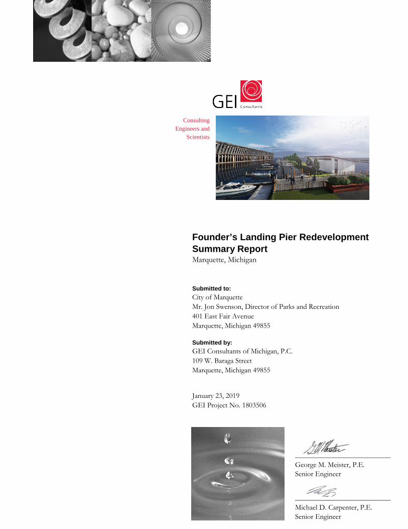
Founder’s Landing Pier Redevelopment Summary Report Marquette, Michigan
Submitted to: City of Marquette Mr. Jon Swenson, Director of Parks and Recreation 401 East Fair Avenue Marquette, Michigan 49855
Submitted by: GEI Consultants of Michigan, P.C. 109 W. Baraga Street Marquette, Michigan 49855
January 23, 2019 GEI Project No. 1803506
__________________________ George M. Meister, P.E. Senior Engineer
__________________________ Michael D. Carpenter, P.E. Senior Engineer

Founder’s Landing Pier Redevelopment Summary Report Marquette, Michigan Project #1803506 January 23, 2019
GEI Consultants of Michigan, P.C. i
Table of Contents
1. Introduction ................................................................................................... 1
1.1 Background ............................................................................................................. 1
1.1.1 Brief History – Spear Merchandise Dock............................................................ 1
1.1.2 Brief History – DSS&A Ore Dock Number 1 ..................................................... 1
1.1.3 Early 1900’s to Now. ........................................................................................... 2
1.2 Project Description and Purpose ............................................................................. 2
2. Field Inspections ........................................................................................... 3
2.1 Substructure Inspection ........................................................................................... 3
2.2 Level I – Visual & Tactile Inspection ..................................................................... 3
2.3 Level II – Up-Close & Detailed Inspection ............................................................ 4
2.4 Level III – Detailed Inspection and Coring ............................................................. 4
2.5 Lake Bottom ............................................................................................................ 4
3. Inspection Findings ...................................................................................... 5
3.1 Below Water ............................................................................................................ 5
3.2 Lake Bottom ............................................................................................................ 7
4. Dock Reuse .................................................................................................... 8
4.1 Structural Assessment ............................................................................................. 8
4.2 Hydrodynamic Assessment ..................................................................................... 9
4.3 Concept Development ........................................................................................... 11
4.4 Cost Opinion ......................................................................................................... 14
Appendices Appendix A: Founder’s Landing Dock Redevelopment Project – Existing and Conceptual Drawings Appendix B: Founder’s Landing Dock Redevelopment Project – Conceptual Cost Opinion
GMM:jp:mdc:lmc W:\Marquette_City\1803506_Marquette_City_Founders_Landing\Final_PDFs\Final Report to City\Founder's Assessment Report_DRAFT_gmm_jp_mdc_lmc.docx

Founder’s Landing Pier Redevelopment Summary Report Marquette, Michigan Project #1803506 January 23, 2019
GEI Consultants of Michigan, P.C. 1
1. Introduction
1.1 Background
The abandoned piers at Founder’s Landing immediately south of the existing DSS&A Number 6 Ore Dock in Marquette may be repurposed by the City. The remains are remnants of Marquette’s historic past along the Lake Superior working waterfront. The piers formerly supported the Duluth, South Shore, and Atlantic Railroad Company (DSS&A) Ore Dock Number 1 on the south and the Spear’s Merchandise Dock on the north pier.
1.1.1 Brief History – Spear Merchandise Dock
In 1855, the Cleveland Iron Mining Company built a dock at the termination of Baraga Avenue. At the time, the pile supported dock was one of the first ore specific docks ever constructed. For ore boats to be loaded, wagons proceeded onto the level dock where the ore was transferred to ships by wheelbarrow. In 1858, the Cleveland dock was reconstructed with 29 elevated pockets with a total capacity of 2,300 tons. The Spear Merchandise Dock was built on the former location of the Cleveland Ore Dock in 1904.
1.1.2 Brief History – DSS&A Ore Dock Number 1
In the 1880’s, the Detroit, Mackinac and Marquette (DM&A) Railroad constructed Ore Dock Number 1 to the south of the Cleveland Ore Dock. In 1886, the DM&A railroad declared bankruptcy before its assets were sold and folded into the consolidated DSS&A Railroad. In the early 1900’s the dock was expanded further into the harbor.
Photo 1 – Spear Dock and DSS&A Ore Dock No. 1 circa 1905
DSS&A Ore Dock #1
Spear Merchandise Dock
Founder’s Landing Pier Redevelopment Summary Report Marquette, Michigan Project #1803506 January 23, 2019
GEI Consultants of Michigan, P.C. 2
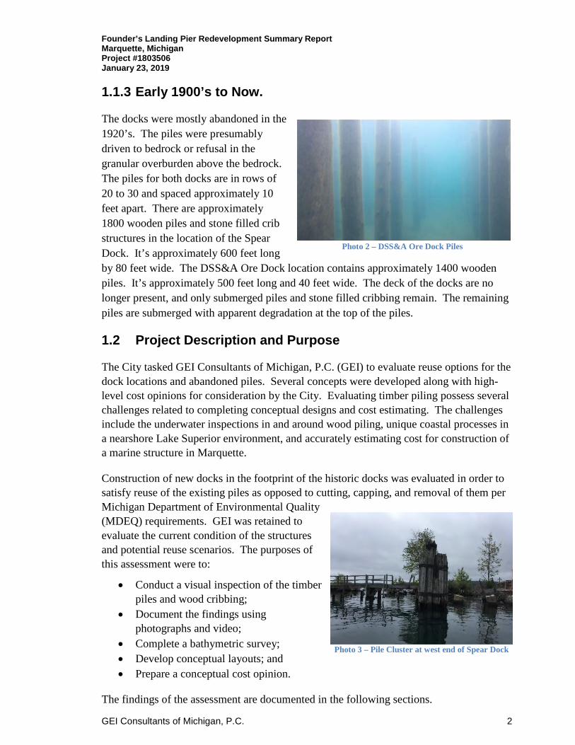
1.1.3 Early 1900’s to Now.
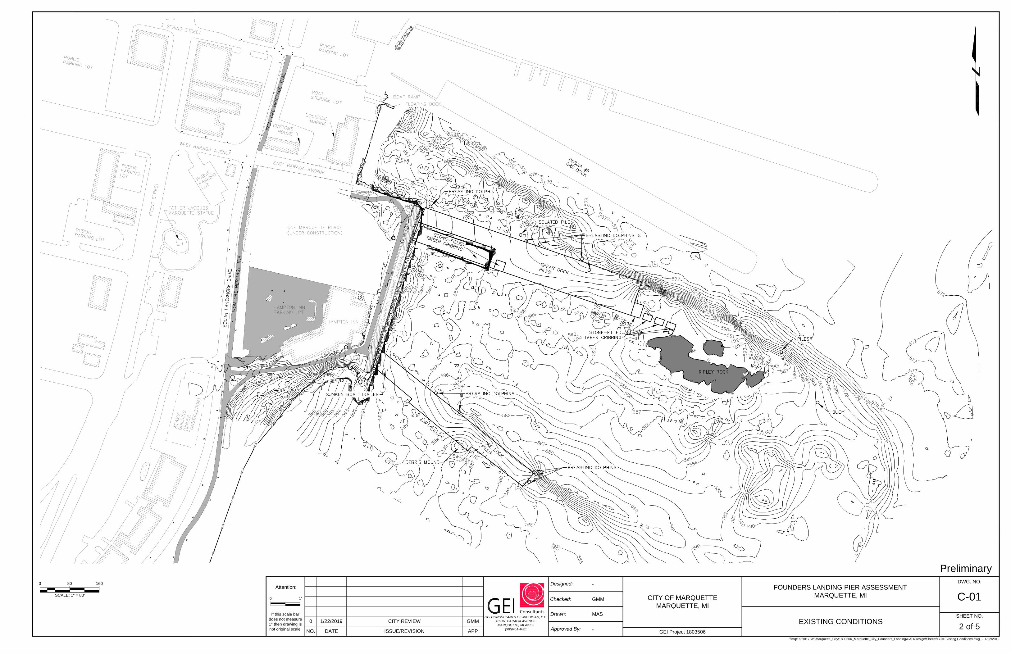
The docks were mostly abandoned in the 1920’s. The piles were presumably driven to bedrock or refusal in the granular overburden above the bedrock. The piles for both docks are in rows of 20 to 30 and spaced approximately 10 feet apart. There are approximately 1800 wooden piles and stone filled crib structures in the location of the Spear Dock. It’s approximately 600 feet long by 80 feet wide. The DSS&A Ore Dock location contains approximately 1400 wooden piles. It’s approximately 500 feet long and 40 feet wide. The deck of the docks are no longer present, and only submerged piles and stone filled cribbing remain. The remaining piles are submerged with apparent degradation at the top of the piles.
1.2 Project Description and Purpose
The City tasked GEI Consultants of Michigan, P.C. (GEI) to evaluate reuse options for the dock locations and abandoned piles. Several concepts were developed along with high-level cost opinions for consideration by the City. Evaluating timber piling possess several challenges related to completing conceptual designs and cost estimating. The challenges include the underwater inspections in and around wood piling, unique coastal processes in a nearshore Lake Superior environment, and accurately estimating cost for construction of a marine structure in Marquette.
Construction of new docks in the footprint of the historic docks was evaluated in order to satisfy reuse of the existing piles as opposed to cutting, capping, and removal of them per Michigan Department of Environmental Quality (MDEQ) requirements. GEI was retained to evaluate the current condition of the structures and potential reuse scenarios. The purposes of this assessment were to:
• Conduct a visual inspection of the timber piles and wood cribbing;
• Document the findings using photographs and video;
• Complete a bathymetric survey; • Develop conceptual layouts; and • Prepare a conceptual cost opinion.
The findings of the assessment are documented in the following sections.
Photo 2 – DSS&A Ore Dock Piles
Photo 3 – Pile Cluster at west end of Spear Dock
Founder’s Landing Pier Redevelopment Summary Report Marquette, Michigan Project #1803506 January 23, 2019
GEI Consultants of Michigan, P.C. 3
2. Field Inspections
GEI mobilized to the Founder’s Landing docks during the month of September 2018. The three-person professional engineer/diver team utilized a 16-foot aluminum boat to complete the inspections. George M. Meister, P.E. conducted the substructure inspection with assistance from Sam Prentice, P.E., Josh Paquet, P.E. and Michael Size, EIT. Video documentation was conducted during the inspections. The inspection approach is summarized in the following sections.
2.1 Substructure Inspection
The dive inspection completed by GEI included checking selected piles and cribbing for weathering, alignment, diameter, and decay. The dive inspection was documented on logs during the inspection, and with underwater video recordings. A description of each type of dive is included in the following sections.
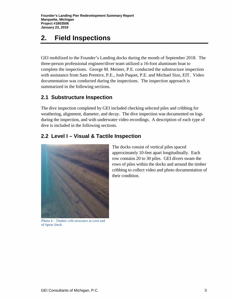
2.2 Level I – Visual & Tactile Inspection
The docks consist of vertical piles spaced approximately 10-feet apart longitudinally. Each row contains 20 to 30 piles. GEI divers swam the rows of piles within the docks and around the timber cribbing to collect video and photo documentation of their condition.
Photo 4 – Timber crib structure at west end of Spear Dock

Founder’s Landing Pier Redevelopment Summary Report Marquette, Michigan Project #1803506 January 23, 2019
GEI Consultants of Michigan, P.C. 4
2.3 Level II – Up-Close & Detailed Inspection
Accessible pile and crib structures were inspected and measured by cleaning marine growth and utilizing picks or awls to determine the soundness of the timber. Approximately 10 percent of the piles were assessed for soundness.
A visual and tactile inspection was completed on the substructure of the Spear Dock beginning at the west end progressing easterly along the north side. The divers swam in a north/south pattern within dock pilings, inspecting select piles and collecting video. The same procedure was repeated for the DSS&A Dock starting from the east end moving to the west. The inspection included up close visual inspection of
the dock footprints, along with timber soundness testing by picks on selected areas of the dock.
2.4 Level III – Detailed Inspection and Coring
GEI divers advanced an 1/8-inch wood core borer into 24 piles at each location. for a total of 48 cores. Samples were collected from the outside of the piles to approximately six to eight inches in depth of these piles. Samples were obtained at a depth below the water surface ranging from 3 feet to 15 feet. This provided a representative sample of the piles. The core samples were then sent to Wood Advisory Services for laboratory testing. Laboratory testing included species identification and bacterial decay
assessment.
2.5 Lake Bottom
The lake bottom was assessed for types of material and depth. Soundings were taken by a SonarMite Hydrolite echosounder and Trimble RTK-GPS unit. A contour map based off the data collected is included in Appendix A. According to the National Oceanic and Atmospheric Administration (NOAA), the average water surface elevation of Lake Superior was 602.75 feet during the inspection.
Photo 5 - Dive inspector measuring timber pile
Photo 6 - Dive inspector boring pile core

Founder’s Landing Pier Redevelopment Summary Report Marquette, Michigan Project #1803506 January 23, 2019
GEI Consultants of Michigan, P.C. 5
3. Inspection Findings
Overall, the structures below water were in good condition and reusable; however, specific elements are noted in the sections below. Structures above water were in generally poor condition.
3.1 Below Water
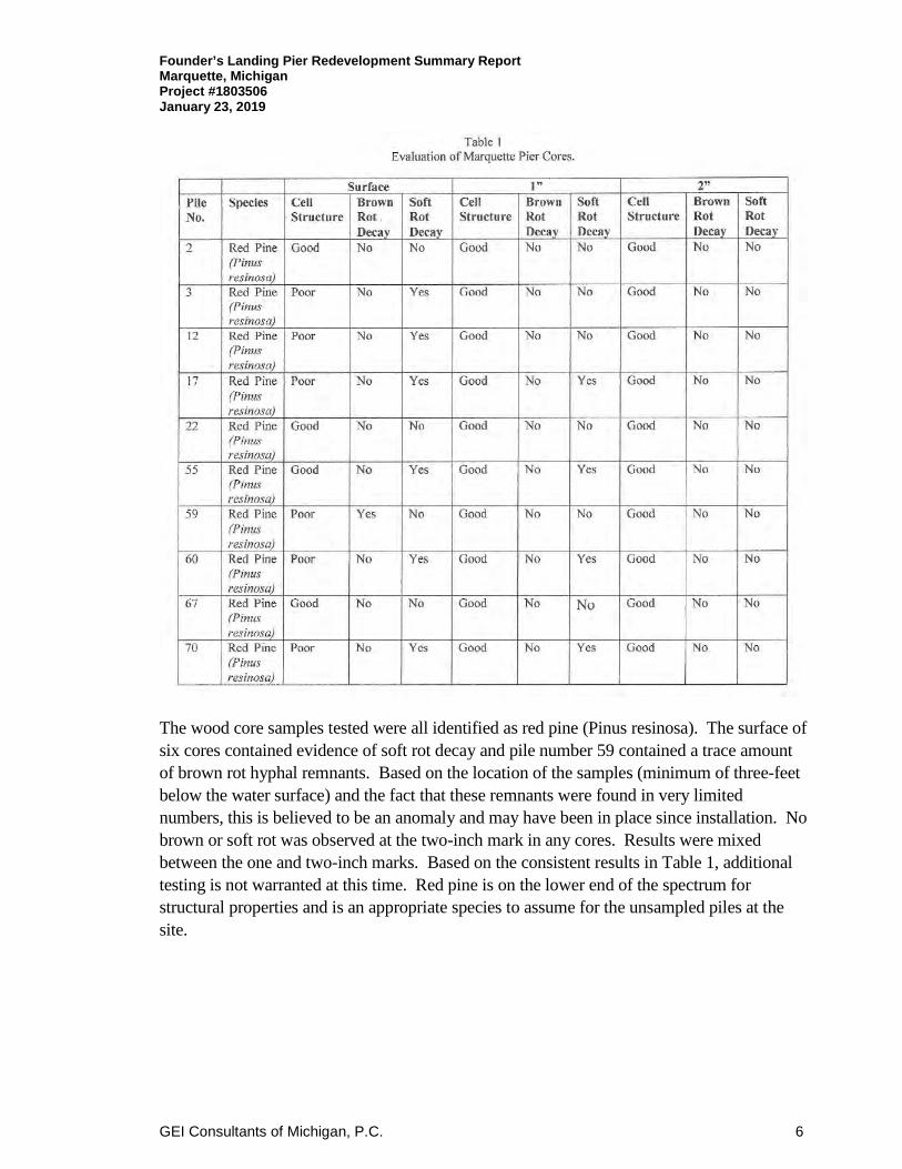
The piles were found to be sound with degradation at the top two to three feet from ice action and decay. The remainder of the piles from roughly three feet below the water surface to the lake bottom were observed to be sound. Five random core samples from each dock were obtained and evaluated. An integer random number generator was used to select the five cores locations from the samples. Each of those randomly selected were evaluated for species identification, presence of brown
rot decay, and the presence of evidence of soft rot decay. The term “evidence of soft rot” is used because soft rot hyphae are so fine they often cannot be seen at the normal magnifications of a light microscope, however, their presence can be determined by viewing cavities and cell wall damage caused by the soft rot. The results of this analysis are presented in Table 1.
Photo 7 - Pile degradation due to ice action and air exposure
Founder’s Landing Pier Redevelopment Summary Report Marquette, Michigan Project #1803506 January 23, 2019
GEI Consultants of Michigan, P.C. 6
The wood core samples tested were all identified as red pine (Pinus resinosa). The surface of six cores contained evidence of soft rot decay and pile number 59 contained a trace amount of brown rot hyphal remnants. Based on the location of the samples (minimum of three-feet below the water surface) and the fact that these remnants were found in very limited numbers, this is believed to be an anomaly and may have been in place since installation. No brown or soft rot was observed at the two-inch mark in any cores. Results were mixed between the one and two-inch marks. Based on the consistent results in Table 1, additional testing is not warranted at this time. Red pine is on the lower end of the spectrum for structural properties and is an appropriate species to assume for the unsampled piles at the site.

Founder’s Landing Pier Redevelopment Summary Report Marquette, Michigan Project #1803506 January 23, 2019
GEI Consultants of Michigan, P.C. 7
The cribbing located in the Spear Dock was also inspected by the divers. The timber was tested for soundness by pick or awl. The large crib structure on the west end of the dock is near the water surface. Due to the top of the structure lying in the ice interface zone, and potentially being exposed to air, it has degraded near the surface. The crib structure from approximately two-feet below the surface was sound. The timber cribbing structures at
the east end of the dock to Ripley Rock were sound and in generally good condition. Iron spikes connecting the timbers were observed to be in good condition.
3.2 Lake Bottom
The lake bottom consists of a fine to medium sand with a covering of silt material. There were occasional deposits of debris within the docks that generally consisted of bricks and lumber. Some miscellaneous debris was found within the piers consisting of lumber, steel rails, rubbish, electrical conduit, and other such items. The bottom is mostly bare with sparse vegetation growth.
GEI mobilized a boat to the site to conduct bathymetric survey of the lake bottom. The survey was completed using a Trimble RTK-GPS and SonarMite HydroLite single beam sonar unit. A grid pattern was travelled while collecting sonar and location data throughout the project area. The information collected was processed in AutoCAD Civil 3D software to create a cad based base map with one-foot contours of the lake bottom.
Photo 9 - Typical lake bottom within docks
Photo 8 - Typical crib structure
Founder’s Landing Pier Redevelopment Summary Report Marquette, Michigan Project #1803506 January 23, 2019
GEI Consultants of Michigan, P.C. 8
4. Dock Reuse
4.1 Structural Assessment
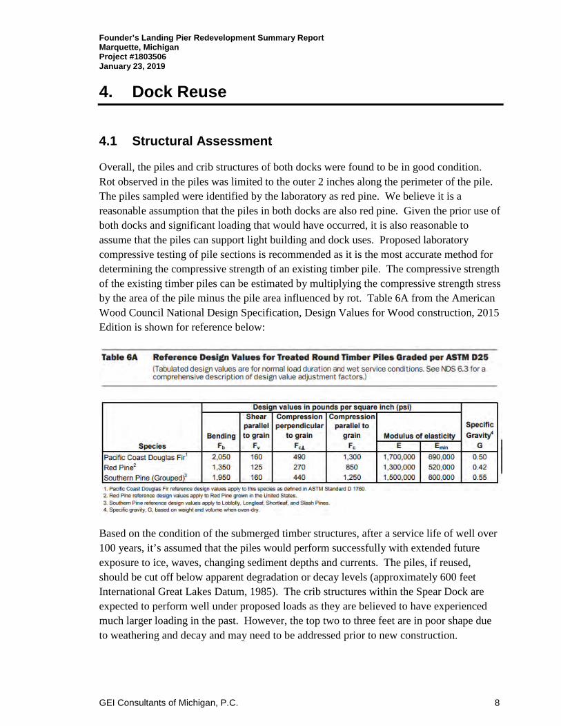
Overall, the piles and crib structures of both docks were found to be in good condition. Rot observed in the piles was limited to the outer 2 inches along the perimeter of the pile. The piles sampled were identified by the laboratory as red pine. We believe it is a reasonable assumption that the piles in both docks are also red pine. Given the prior use of both docks and significant loading that would have occurred, it is also reasonable to assume that the piles can support light building and dock uses. Proposed laboratory compressive testing of pile sections is recommended as it is the most accurate method for determining the compressive strength of an existing timber pile. The compressive strength of the existing timber piles can be estimated by multiplying the compressive strength stress by the area of the pile minus the pile area influenced by rot. Table 6A from the American Wood Council National Design Specification, Design Values for Wood construction, 2015 Edition is shown for reference below:
Based on the condition of the submerged timber structures, after a service life of well over 100 years, it’s assumed that the piles would perform successfully with extended future exposure to ice, waves, changing sediment depths and currents. The piles, if reused, should be cut off below apparent degradation or decay levels (approximately 600 feet International Great Lakes Datum, 1985). The crib structures within the Spear Dock are expected to perform well under proposed loads as they are believed to have experienced much larger loading in the past. However, the top two to three feet are in poor shape due to weathering and decay and may need to be addressed prior to new construction.
Founder’s Landing Pier Redevelopment Summary Report Marquette, Michigan Project #1803506 January 23, 2019
GEI Consultants of Michigan, P.C. 9
4.2 Hydrodynamic Assessment
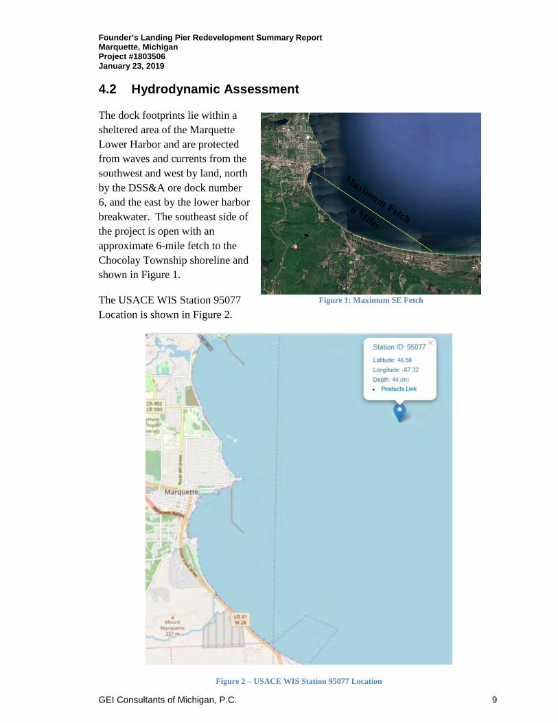
The dock footprints lie within a sheltered area of the Marquette Lower Harbor and are protected from waves and currents from the southwest and west by land, north by the DSS&A ore dock number 6, and the east by the lower harbor breakwater. The southeast side of the project is open with an approximate 6-mile fetch to the Chocolay Township shoreline and shown in Figure 1.
The USACE WIS Station 95077 Location is shown in Figure 2.
Figure 2 – USACE WIS Station 95077 Location
Figure 1: Maximum SE Fetch
Founder’s Landing Pier Redevelopment Summary Report Marquette, Michigan Project #1803506 January 23, 2019
GEI Consultants of Michigan, P.C. 10
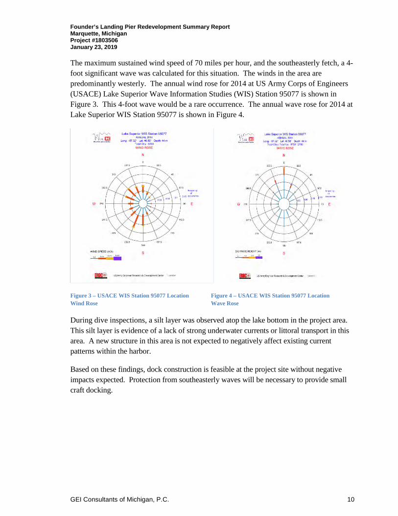
The maximum sustained wind speed of 70 miles per hour, and the southeasterly fetch, a 4-foot significant wave was calculated for this situation. The winds in the area are predominantly westerly. The annual wind rose for 2014 at US Army Corps of Engineers (USACE) Lake Superior Wave Information Studies (WIS) Station 95077 is shown in Figure 3. This 4-foot wave would be a rare occurrence. The annual wave rose for 2014 at Lake Superior WIS Station 95077 is shown in Figure 4.
Figure 3 – USACE WIS Station 95077 Location Figure 4 – USACE WIS Station 95077 Location Wind Rose Wave Rose
During dive inspections, a silt layer was observed atop the lake bottom in the project area. This silt layer is evidence of a lack of strong underwater currents or littoral transport in this area. A new structure in this area is not expected to negatively affect existing current patterns within the harbor.
Based on these findings, dock construction is feasible at the project site without negative impacts expected. Protection from southeasterly waves will be necessary to provide small craft docking.
Founder’s Landing Pier Redevelopment Summary Report Marquette, Michigan Project #1803506 January 23, 2019
GEI Consultants of Michigan, P.C. 11
4.3 Concept Development
GEI worked with the City Parks and Recreation Department, Harbor Advisory Committee (HAC) and several citizen groups to develop the final conceptual layout. GEI presented the project to the HAC and citizen groups at their regular meeting on October 4, 2018.
Some of the groups who provided input included; Marquette Dock Association, UP Rowing Club, Marquette Arts and Culture Advisory Committee, Public Arts Commission, and the Marquette Regional History Center. Generally, input received from the public included interest in the following features:
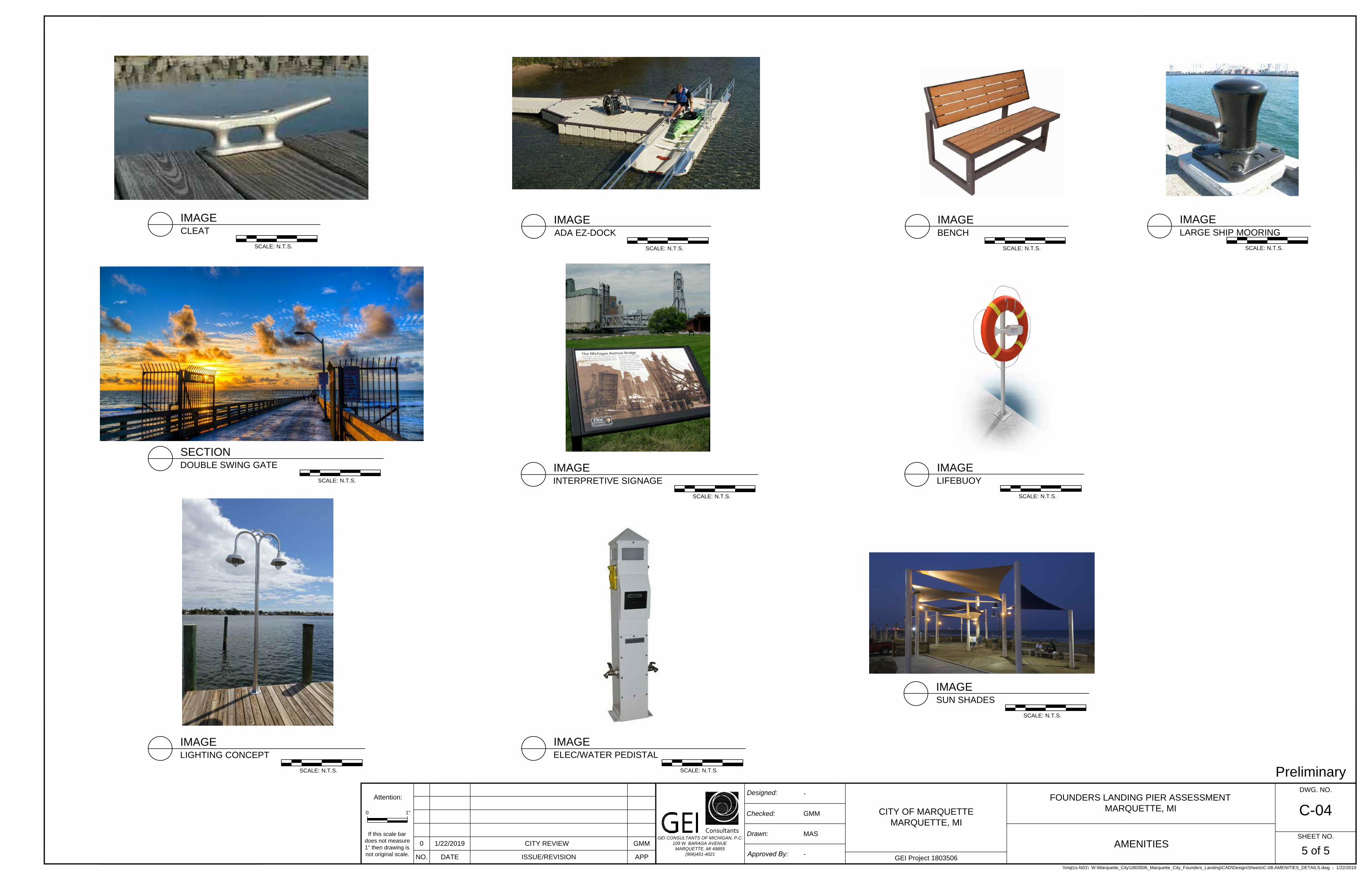
• Transient Boat Dockage with electricity and water hookups; • Tiered Dockage for multiple size boats; • Open pavilions for multiple uses; • Rowing club/community boat storage and launching; • Public space; • Interpretive Signage; • Fishing access; • Picnic facilities; • Spaces for marriages and photos; • Universal access; • Public art; and • Bike racks.
Conversely, public input received did not support:
• Connection to Ripley Rock; • Retail or food services that would compete with downtown businesses; and • Marina use like existing City facilities.
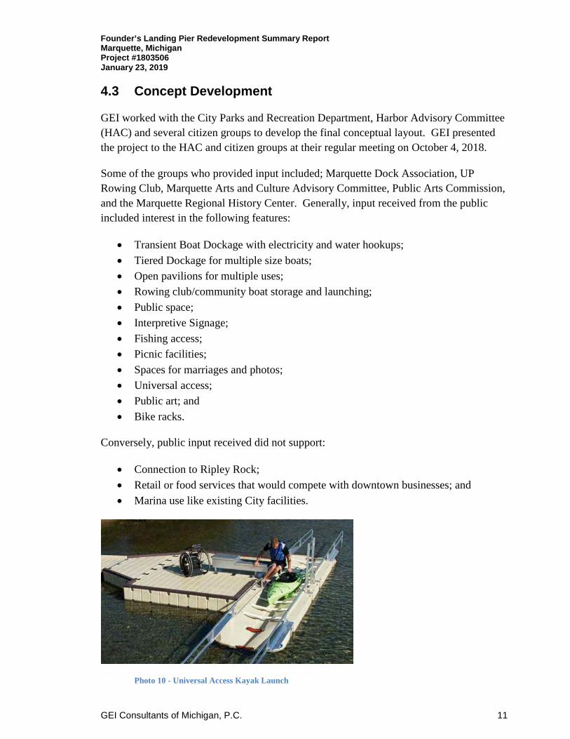
Photo 10 - Universal Access Kayak Launch
Founder’s Landing Pier Redevelopment Summary Report Marquette, Michigan Project #1803506 January 23, 2019
GEI Consultants of Michigan, P.C. 12
Preliminary concepts were presented to the Harbor Advisory Committee at their December 11, 2018 meeting. These concepts included several potential options that could be included as part of the final project such as; full dock reconstruction with timber decking, fishing decks, fish habitat structures, pavilions, wave attenuation devices, along with other amenities. The concepts were presented along with concept level cost opinions to further inform recommendations. Construction, or features, that require underwater work is, generally, significantly more expensive than conventional construction. Based on this information, additional direction was received from the committee and included in the final concept.
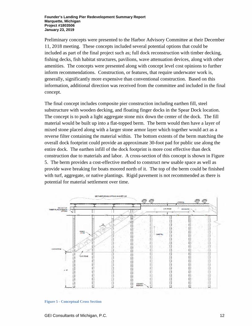
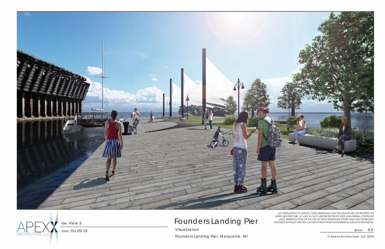
The final concept includes composite pier construction including earthen fill, steel substructure with wooden decking, and floating finger docks in the Spear Dock location. The concept is to push a light aggregate stone mix down the center of the dock. The fill material would be built up into a flat-topped berm. The berm would then have a layer of mixed stone placed along with a larger stone armor layer which together would act as a reverse filter containing the material within. The bottom extents of the berm matching the overall dock footprint could provide an approximate 30-foot pad for public use along the entire dock. The earthen infill of the dock footprint is more cost effective than deck construction due to materials and labor. A cross-section of this concept is shown in Figure 5. The berm provides a cost-effective method to construct new usable space as well as provide wave breaking for boats moored north of it. The top of the berm could be finished with turf, aggregate, or native plantings. Rigid pavement is not recommended as there is potential for material settlement over time.
Figure 5 - Conceptual Cross Section
Founder’s Landing Pier Redevelopment Summary Report Marquette, Michigan Project #1803506 January 23, 2019
GEI Consultants of Michigan, P.C. 13
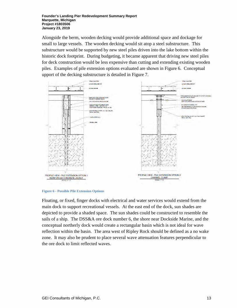
Alongside the berm, wooden decking would provide additional space and dockage for small to large vessels. The wooden decking would sit atop a steel substructure. This substructure would be supported by new steel piles driven into the lake bottom within the historic dock footprint. During budgeting, it became apparent that driving new steel piles for deck construction would be less expensive than cutting and extending existing wooden piles. Examples of pile extension options evaluated are shown in Figure 6. Conceptual upport of the decking substructure is detailed in Figure 7.
Figure 6 - Possible Pile Extension Options
Floating, or fixed, finger docks with electrical and water services would extend from the main dock to support recreational vessels. At the east end of the dock, sun shades are depicted to provide a shaded space. The sun shades could be constructed to resemble the sails of a ship. The DSS&A ore dock number 6, the shore near Dockside Marine, and the conceptual northerly dock would create a rectangular basin which is not ideal for wave reflection within the basin. The area west of Ripley Rock should be defined as a no wake zone. It may also be prudent to place several wave attenuation features perpendicular to the ore dock to limit reflected waves.

Founder’s Landing Pier Redevelopment Summary Report Marquette, Michigan Project #1803506 January 23, 2019
GEI Consultants of Michigan, P.C. 14
Figure 7 - Deck Substructure Construction (Existing Piles vs. New Piles)
The DSS&A dock location concept includes a boardwalk with railings extending over the water to an observation deck at the end of the dock. The budget for this construction also includes new steel piles for the boardwalk and deck construction with steel substructure and wooden decking. The south dock was determined by the HAC to be better utilized by constructing minimal improvements to conserve budget for the Spear Dock. Conceptual renderings are included Appendix C.
4.4 Cost Opinion
Durocher Marine, a marine contractor based in Cheboygan, Michigan assisted GEI in conceptual budget development. The conceptual budget is based on current marine construction costs that should be expected in the Marquette area. Much could change from the conceptual construction assumptions during the final design process. The cost opinion provided is very preliminary at this time and should be expected to fluctuate as construction details are finalized and amenities selected. The budget is broken down to the significant proposed improvements and included in Appendix B. A high-level cost opinion was developed for the concept discussed above in section 5.3. The anticipated budget necessary to complete the project is approximately $5,000,000. A $10,000,000 budget could be expected to reconstruct wooden docks covering the entire historic footprints.
GEI Consultants of Michigan, P.C.
Appendix A
Appendix A: Founder’s Landing Dock Redevelopment Project – Existing and Conceptual Drawings
\\mqt1s-fs01\ W:\Marquette_City\1803506_Marquette_City_Founders_Landing\CAD\Design\Sheets\G-01-COVER.dwg - 11/29/2018
COUNTY MAP
(NOT TO SCALE)
SITE LOCATION MAP
(NOT TO SCALE)
FOUNDERS LANDING PIER REDEVELOPMENT
CITY OF MARQUETTE
MARQUETTE, MICHIGAN
GEI PROJECT NO. 1803506
January 23rd, 2019
SITE
SOURCE:
BINGMAPS
SOURCE:
ON THE WORLD MAP
PREPARED FOR:
CITY OF MARQUETTE
300 W BARAGA AVE
MARQUETTE, MI
(906)228-0435
Consultants
PREPARED BY:
GEI CONSULTANTS OF MICHIGAN, P.C.
109 W. BARAGA AVENUE
MARQUETTE, MI 49855
(906)451-4021
Preliminary
DRAFT
DWG. NO.DWG. NO.
SHEET NO.
REV NO.
G-01
1 OF 5
0
THIS DOCUMENT, AND THE IDEAS AND DESIGNS INCORPORATED
HEREIN, IS AN INSTRUMENT OF PROFESSIONAL SERVICE, IS THE
PROPERTY OF GEI CONSULTANTS AND IS NOT TO BE USED, IN WHOLE
OR IN PART, FOR ANY OTHER PROJECT WITHOUT THE WRITTEN
AUTHORIZATION OF GEI CONSULTANTS.
SITE
SHEET INDEX
SHEET NO. DRAWING NO. TITLE
1 G-01 COVER SHEET
2 C-01 EXISTING CONDITIONS
3 C-02 CONCEPTUAL OPTION NO.1
4 C-03 CONCEPTUAL OPTION NO.2
5 C-04 AMENITIES
Consultants
W
T
R
W
T
R
W
T
R
W
T
R
W
T
R
W
T
R
W
T
R
W
T
R
WT
R
W
T
R
W
T
R
WT
R
W
T
R
W
T
R
W
T
R
U
U
U
U
U
U
U
U
U
MH
MH
MH
MH
MH
MH
MH
MH
MH
W
T
R
W
T
R
W
T
R
W
T
R
W
T
R
W
T
R
W
T
R
W
T
R
W
T
R
W
T
R
W
T
R
W
T
R
W
T
R
W
T
R
W
T
R
U
U
U
U
U
U
U
U
MH
MH
MH
MH
MH
MH
MH
MH
MH
MH
U
U
U
MH
MH
MH
MH
MH
MH
MH
MH
MH
MH
MH
MH
MH
MH
MH
MH
MH
U
U
U
U
U
U
U
U
U
U
U
MH
U
U
U
U
MH
MH
MH
\\mqt1s-fs01\ W:\Marquette_City\1803506_Marquette_City_Founders_Landing\CAD\Design\Sheets\C-01Existing Conditions.dwg - 1/22/2019
CITY OF MARQUETTE
MARQUETTE, MI
GEI Project 1803506
If this scale bar
does not measure
1" then drawing is
not original scale.
Attention:
FOUNDERS LANDING PIER ASSESSMENT
MARQUETTE, MI
EXISTING CONDITIONS
GEI CONSULTANTS OF MICHIGAN, P.C.
109 W. BARAGA AVENUE
MARQUETTE, MI 49855
(906)451-4021
Consultants
0 1"
NO. DATE ISSUE/REVISION APP
0 1/22/2019 CITY REVIEW GMM
Designed:
Checked:
Drawn:
-
GMM
MAS
Approved By: -
Preliminary
SHEET NO.
DWG. NO.
2 of 5
C-01
0
SCALE:
80 160
1" = 80'

W
T
R
W
T
R
W
T
R
W
T
R
W
T
R
W
T
R
W
T
R
W
T
R
WT
R
W
T
R
W
T
R
WT
R
W
T
R
W
T
R
W
T
R
W
T
R
W
T
R
W
T
R
W
T
R
W
T
R
W
T
R
W
T
R
W
T
R
WT
R
W
T
R
W
T
R
WT
R
W
T
R
W
T
R
W
T
R
U
U
U
U
U
U
U
U
U
MH
MH
MH
MH
MH
MH
MH
MH
MH
W
T
R
W
T
R
W
T
R
W
T
R
W
T
R
W
T
R
W
T
R
W
T
R
W
T
R
W
T
R
W
T
R
W
T
R
W
T
R
W
T
R
W
T
R
U
U
U
U
U
U
U
U
MH
MH
MH
MH
MH
MH
MH
MH
MH
MH
U
U
U
MH
MH
MH
MH
MH
MH
MH
MH
MH
MH
MH
MH
MH
MH
MH
MH
MH
U
U
U
U
U
U
U
U
U
U
U
MH
U
U
U
U
MH
MH
MH
---- W:\Marquette_City\1803506_Marquette_City_Founders_Landing\CAD\Design\Sheets\C-02-CONCEPTUAL OPTION No.1.dwg - 1/22/2019
CITY OF MARQUETTE
MARQUETTE, MI
GEI Project 1803506
If this scale bar
does not measure
1" then drawing is
not original scale.
Attention:
FOUNDERS LANDING PIER ASSESSMENT
MARQUETTE, MI
CONCEPTUAL OPTION
(PLAN 1)
GEI CONSULTANTS OF MICHIGAN, P.C.
109 W. BARAGA AVENUE
MARQUETTE, MI 49855
(906)451-4021
Consultants
0 1"
NO. DATE ISSUE/REVISION APP
0 1/22/2019 CITY REVIEW GMM
Designed:
Checked:
Drawn:
-
GMM
MAS
Approved By: -
Preliminary
SHEET NO.
DWG. NO.
3 of 5
C-02
0
SCALE:
80 160
1" = 80'
Rowing/Kayak Storage

W
T
R
W
T
R
W
T
R
W
T
R
W
T
R
W
T
R
W
T
R
W
T
R
W
T
R
W
T
R
WT
R
W
T
R
W
T
R
WT
R
W
T
R
W
T
R
W
T
R
U
U
U
U
U
U
U
U
U
MH
MH
MH
MH
MH
MH
MH
MH
MH
W
T
R
W
T
R
W
T
R
W
T
R
W
T
R
W
T
R
W
T
R
W
T
R
W
T
R
W
T
R
W
T
R
W
T
R
W
T
R
W
T
R
W
T
R
U
U
U
U
U
U
U
U
MH
MH
MH
MH
MH
MH
MH
MH
MH
MH
U
U
U
MH
MH
MH
MH
MH
MH
MH
MH
MH
MH
MH
MH
MH
MH
MH
MH
MH
U
U
U
U
U
U
U
U
U
U
U
MH
U
U
U
U
MH
MH
MH
---- W:\Marquette_City\1803506_Marquette_City_Founders_Landing\CAD\Design\Sheets\C-03-CONCEPTUAL OPTION No.2.dwg - 12/3/2018
CITY OF MARQUETTE
MARQUETTE, MI
GEI Project 1803506
If this scale bar
does not measure
1" then drawing is
not original scale.
Attention:
FOUNDERS LANDING PIER ASSESSMENT
MARQUETTE, MI
CONCEPTUAL OPTION
(PLAN 2)
GEI CONSULTANTS OF MICHIGAN, P.C.
109 W. BARAGA AVENUE
MARQUETTE, MI 49855
(906)451-4021
Consultants
0 1"
NO. DATE ISSUE/REVISION APP
0 1/22/2019 CITY REVIEW GMM
Designed:
Checked:
Drawn:
-
GMM
MAS
Approved By: -
Preliminary
SHEET NO.
DWG. NO.
4 of 5
C-03
0
SCALE:
80 160
1" = 80'
\\mqt1s-fs01\ W:\Marquette_City\1803506_Marquette_City_Founders_Landing\CAD\Design\Sheets\C-08-AMENITIES_DETAILS.dwg - 1/22/2019
If this scale bar
does not measure
1" then drawing is
not original scale.
Attention:
AMENITIES
GEI CONSULTANTS OF MICHIGAN, P.C.
109 W. BARAGA AVENUE
MARQUETTE, MI 49855
(906)451-4021
Consultants
0 1"
NO. DATE ISSUE/REVISION APP
0 1/22/2019 CITY REVIEW GMM
Designed:
Checked:
Drawn:
-
GMM
MAS
Approved By: -
Preliminary
SHEET NO.
DWG. NO.
5 of 5
C-04CITY OF MARQUETTE
MARQUETTE, MI
GEI Project 1803506
FOUNDERS LANDING PIER ASSESSMENT
MARQUETTE, MI
SCALE: N.T.S.
CLEAT
IMAGE
SCALE: N.T.S.
DOUBLE SWING GATE
SECTION
SCALE: N.T.S.
LIGHTING CONCEPT
IMAGE
SCALE: N.T.S.
INTERPRETIVE SIGNAGE
IMAGE
SCALE: N.T.S.
LIFEBUOY
IMAGE
SCALE: N.T.S.
ELEC/WATER PEDISTAL
IMAGE
SCALE: N.T.S.
BENCH
IMAGE
SCALE: N.T.S.
ADA EZ-DOCK
IMAGE
SCALE: N.T.S.
SUN SHADES
IMAGE
SCALE: N.T.S.
LARGE SHIP MOORING
IMAGE
GEI Consultants of Michigan, P.C.
Appendix B
Founder’s Landing Dock Redevelopment Project – Conceptual Cost Opinion
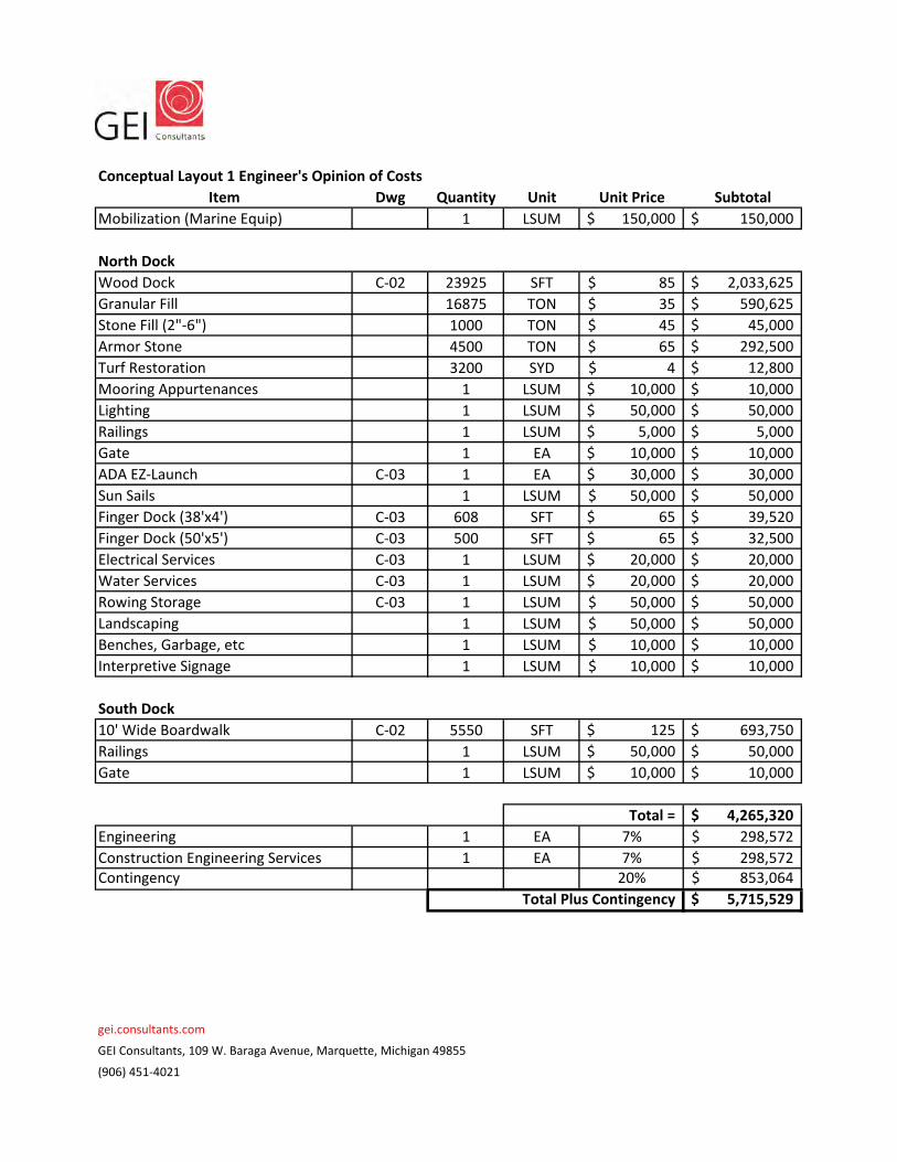
Conceptual Layout 1 Engineer's Opinion of Costs
Item Dwg Quantity Unit Unit Price Subtotal
Mobilization (Marine Equip) 1 LSUM 150,000$ 150,000$
North Dock
Wood Dock C‐02 23925 SFT 85$ 2,033,625$
Granular Fill 16875 TON 35$ 590,625$
Stone Fill (2"‐6") 1000 TON 45$ 45,000$
Armor Stone 4500 TON 65$ 292,500$
Turf Restoration 3200 SYD 4$ 12,800$
Mooring Appurtenances 1 LSUM 10,000$ 10,000$
Lighting 1 LSUM 50,000$ 50,000$
Railings 1 LSUM 5,000$ 5,000$
Gate 1 EA 10,000$ 10,000$
ADA EZ‐Launch C‐03 1 EA 30,000$ 30,000$
Sun Sails 1 LSUM 50,000$ 50,000$
Finger Dock (38'x4') C‐03 608 SFT 65$ 39,520$
Finger Dock (50'x5') C‐03 500 SFT 65$ 32,500$
Electrical Services C‐03 1 LSUM 20,000$ 20,000$
Water Services C‐03 1 LSUM 20,000$ 20,000$
Rowing Storage C‐03 1 LSUM 50,000$ 50,000$
Landscaping 1 LSUM 50,000$ 50,000$
Benches, Garbage, etc 1 LSUM 10,000$ 10,000$
Interpretive Signage 1 LSUM 10,000$ 10,000$
South Dock
10' Wide Boardwalk C‐02 5550 SFT 125$ 693,750$
Railings 1 LSUM 50,000$ 50,000$
Gate 1 LSUM 10,000$ 10,000$
4,265,320$
Engineering 1 EA 7% 298,572$
Construction Engineering Services 1 EA 7% 298,572$ Contingency 20% 853,064$
5,715,529$
gei.consultants.com
GEI Consultants, 109 W. Baraga Avenue, Marquette, Michigan 49855
(906) 451‐4021
Total =
Total Plus Contingency

GEI Consultants of Michigan, P.C.
Appendix C
Founder’s Landing Dock Redevelopment Project – Conceptual Development Rendering

APEXARCHITECTURE, LLC
Founders Landing Pier
Founders Landing Pier, Marquette, MI
Visualizationdate: 01/25/19 sheet: A1
AS INSTRUMENTS OF SERVICE, THESE DRAWINGS AND THE DESIGN ARE THE PROPERTY OF APEXX ARCHITECTURE, LLC AND AS SUCH ARE PROTECTED BY STATE AND FEDERAL COPYRIGHT
LAWS. REPRODUCTION OR THE USE OF THESE DRAWINGS OTHER THAN FOR THE PROJECT INTENDED WITHOUT WRITTEN CONSENT FROM FINLEY ENGINEERING GROUP IS PROHIBITED.title: View 1
© Apexx Architecture, LLC 2019

APEXARCHITECTURE, LLC
Founders Landing Pier
Founders Landing Pier, Marquette, MI
Visualizationdate: 01/25/19 sheet: A2
AS INSTRUMENTS OF SERVICE, THESE DRAWINGS AND THE DESIGN ARE THE PROPERTY OF APEXX ARCHITECTURE, LLC AND AS SUCH ARE PROTECTED BY STATE AND FEDERAL COPYRIGHT
LAWS. REPRODUCTION OR THE USE OF THESE DRAWINGS OTHER THAN FOR THE PROJECT INTENDED WITHOUT WRITTEN CONSENT FROM FINLEY ENGINEERING GROUP IS PROHIBITED.title: View 2
© Apexx Architecture, LLC 2019
APEXARCHITECTURE, LLC
Founders Landing Pier
Founders Landing Pier, Marquette, MI
Visualizationdate: 01/25/19 sheet: A3
AS INSTRUMENTS OF SERVICE, THESE DRAWINGS AND THE DESIGN ARE THE PROPERTY OF APEXX ARCHITECTURE, LLC AND AS SUCH ARE PROTECTED BY STATE AND FEDERAL COPYRIGHT
LAWS. REPRODUCTION OR THE USE OF THESE DRAWINGS OTHER THAN FOR THE PROJECT INTENDED WITHOUT WRITTEN CONSENT FROM FINLEY ENGINEERING GROUP IS PROHIBITED.title: View 3
© Apexx Architecture, LLC 2019

APEXARCHITECTURE, LLC
Founders Landing Pier
Founders Landing Pier, Marquette, MI
Visualizationdate: 01/25/19 sheet: A4
AS INSTRUMENTS OF SERVICE, THESE DRAWINGS AND THE DESIGN ARE THE PROPERTY OF APEXX ARCHITECTURE, LLC AND AS SUCH ARE PROTECTED BY STATE AND FEDERAL COPYRIGHT
LAWS. REPRODUCTION OR THE USE OF THESE DRAWINGS OTHER THAN FOR THE PROJECT INTENDED WITHOUT WRITTEN CONSENT FROM FINLEY ENGINEERING GROUP IS PROHIBITED.title: View 4
© Apexx Architecture, LLC 2019

APEXARCHITECTURE, LLC
Founders Landing Pier
Founders Landing Pier, Marquette, MI
Visualizationdate: 01/25/19 sheet: A5
AS INSTRUMENTS OF SERVICE, THESE DRAWINGS AND THE DESIGN ARE THE PROPERTY OF APEXX ARCHITECTURE, LLC AND AS SUCH ARE PROTECTED BY STATE AND FEDERAL COPYRIGHT
LAWS. REPRODUCTION OR THE USE OF THESE DRAWINGS OTHER THAN FOR THE PROJECT INTENDED WITHOUT WRITTEN CONSENT FROM FINLEY ENGINEERING GROUP IS PROHIBITED.title: View 5
© Apexx Architecture, LLC 2019

APEXARCHITECTURE, LLC
Founders Landing Pier
Founders Landing Pier, Marquette, MI
Visualizationdate: 01/11/19 sheet: A6
AS INSTRUMENTS OF SERVICE, THESE DRAWINGS AND THE DESIGN ARE THE PROPERTY OF APEXX ARCHITECTURE, LLC AND AS SUCH ARE PROTECTED BY STATE AND FEDERAL COPYRIGHT
LAWS. REPRODUCTION OR THE USE OF THESE DRAWINGS OTHER THAN FOR THE PROJECT INTENDED WITHOUT WRITTEN CONSENT FROM FINLEY ENGINEERING GROUP IS PROHIBITED.title: View 6
© Apexx Architecture, LLC 2019

APEXARCHITECTURE, LLC
Founders Landing Pier
Founders Landing Pier, Marquette, MI
Visualizationdate: 01/25/19 sheet: A7
AS INSTRUMENTS OF SERVICE, THESE DRAWINGS AND THE DESIGN ARE THE PROPERTY OF APEXX ARCHITECTURE, LLC AND AS SUCH ARE PROTECTED BY STATE AND FEDERAL COPYRIGHT
LAWS. REPRODUCTION OR THE USE OF THESE DRAWINGS OTHER THAN FOR THE PROJECT INTENDED WITHOUT WRITTEN CONSENT FROM FINLEY ENGINEERING GROUP IS PROHIBITED.title: View 7
© Apexx Architecture, LLC 2019