formaming survey manuscripts for review and editing … · · 2012-07-06formaming survey...
TRANSCRIPT

FORMAmING SURVEY MANUSCRIPTS FOR REVIEW AND EDITING
T HIS SECTION TELLS HOW GENERAL GU~DEL~NES to format a Survey manu- script for technical review, editing, FOR THE ENTIRE and Director's approval, whether MAN USCR~ PT formatted by a typist or by you yourself. General guidelines that 1. Use S1/2- by 11-inch white apply to the entire manuscript are paper; continuous-feed com- listed first, followed by details puter paper is acceptable, specific to particular parts. Few but you should set the page manuscripts are likely to have ,length so that copy does not every part listed here. Most of the print on or close to the bot- information applies to any techni- tom or side perforations. cal manuscript; information that is 2, Leave a margin of at least specific to formal USGS series 1 inch all around each page. books or maps is so indicated. 3. Number pages consecutively;
if there is a break, indicate in the following manner which
WHERE TO BEGIN page follows:
Before you begin work on your 18 (p. 34 follows) manuscript, gather all needed materials. You will need a recent This kind of notation assures sample of the publication, publish- a reader that no pages are er's instructions, pertinent style missing. Letters can be added manuals (such as this book), pub- to page numbers (when lished examples of particular items material is inserted, for ex- (such as measured sections), and ample), but the page follow- any specialized dictionaries or ing the last lettered number reference books. Of course for should be indicated in the checking spelling and word usage same way: you will have access to a diction- ary (USGS and GPO recommend 18d (p. 34 follows)
"~ebs t e r ' s Third New Interna- tional Dictionary" for spelling), and "The Glossary of Geology, third edition" (Bates and Jackson, 1987). If your manuscript is to be published by the USGS, your local manuscript processing office will have guidelines for you. Take a
Double space all text, tables, and figure captions. Avoid dividing ,words at the end of a line; use the wrap- around feature on word processor or computer (so there are no carriage returns at the ends of sentences
few minutes to look through what within a paragraph). is appropriate in those instructions 6. Complete paragraphs on a and books so that your keyboard- page, for easier review and ing session will be efficient and editing, even if the page runs fruitful. short.
7. Rank of heading is indicated by number of spaces the heading is indented in the table of "Contents."
Professional Papers.
CENTER AND CAPITALIZE ALL HEADINGS
Bulletins, Circulars, and Water-Supply Papers. Type headings flush left for first three ranks and center head- ings of lower rank; capitalize or lowercase letters as follows:
FIRST-RANK HEADING ALL CAPS,
flush left
Second-Rank Heading Cap and
Lowercase, flush left
Third-Rank Heading Cap and
Lowercase, flush left
Fourth-Rank Heading Cap and
Lowercase, center
8. Leave right margins ragged (not right-justified)-copy is easier to read.
9. Underline letters or words that are to be typeset in italic if your word processor does not have an italic typeface.
10. CapitJize and abbreviate ac- cording to guides in this book and in the GPO Style Manual for reports to be published by the USCS. Follow publisher's guide for reports to be pub- lished outside the USGS.
250 Formatting Survey manuscripts for review and editing
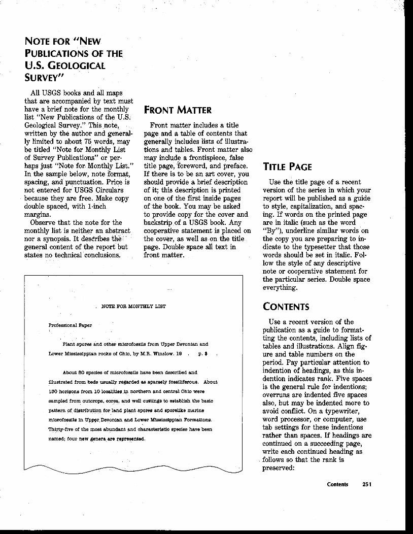
NOTE FOR "NEW PUBLICATIONS OF THE U.S. GEOLOGICAL SURVEY"
All USGS books and all maps that are accompanied by text must have a brief note for the monthly list "New Publications of the U.S. Geological Survey." This note, written by the author and general- ly limited to about 75 words, may be titled "Note for Monthly List of Survey Publications" or per- haps just "Note for Monthly List." In the sample below, note format, spacing, and punctuation. Price is not entered for USGS Circulars because they are free. Make copy double spaced, with l-inch margins.
Observe that the note for the monthly list is neither an abstract nor a synopsis. I t describes 'the general content of the report but states no technical conclusions.
Front matter includes a title page and a table of contents that generally includes lists of illustra- tions and tables. Front matter also may include a frontispiece, false title page, foreword, and preface. If there is to be an art cover, you sho$dd provide a brief description of it; this description is printed on one of the first inside pages of the book. You may be asked to provide copy for the cover and backstrip of a USGS book. Any cooperative statement is placed on the coKer, as well as on the title page. Double space all text in front mattef.
Professional Paper
NOTE FOR MONTHLY LIST
Plant spores and other miorofoseile from Upper Devonian and
Lower Mississippian rocks of Ohio, by M.R. Winslow. 19 . p. $ .
About 80 species of miorofossils have been described and
illustrated from beds usually regarded as sparsely foeeiliferoue. About
130 horizons from 10 looallties in northern and central Ohio were
sampled from Outorops, ooree, and well outtings to establish the basic
pattern of dietribution for land plant spores and sporelike marine
miorofossils in Upper Devonian and Lower Missiesippian Formations.
Thirty-five of the most abundant and oharaoterietio speoiee have been
named; four new genera are represented.
Use the title page of a recent version of the series in which your report will be published as a guide to style, capitalization, and spac- ing. If words on the printed page are in italic (such as the word "By"), underline similar words on the copy you are preparing to in- dicate to the typesetter that those words should be set in italic. Fol- low the style of any descriptive note or cooperative statement for the particular series. Double space everything.
Use a recent version of the publication as a guide to format- ting the contents, including lists of tables and illustrations. Align fig- ure and table numbers on the period. Pay particular attention to indention of headings, as this in- dention indicates rank. Five spaces is the general rule for indentions; overruns are indented five spaces also, but may be indented more to avoid conflict. On a typewriter, word processor, or computer, use tab settings for these indentions rather than spaces. If headings are continued on a succeeding page, write each continued heading as follows so that the rank is preserved:
Contents 251

Beoond-rank heading (indented five spaoe8)--Continued
I New third-rank headtng (indented five spaces) ----------------- 1 I
Either dot or dash leaders are ac- LIST OF ILLUSTRATIONS ceptable. Run the leader from the last line of the entry (see sample The list of illustrations, which "Illustrations" page). Some publi- follows the "Contents," consists of cations, such as the S1/2- by 11-inch short titles (not necessarily the USGS Bulletin, have no leaders at entire caption), in which the illus- all. Type page numbers at the end trations are identified as to kind, of the leaders to indicate to the such as map, diagram, or photo- reviewer or editor the page in the graph. Four or more similar kinds manuscript on which the item of illustrations listed consecutively (such as a figure) appears or the may be grouped and indented page on which it is first men- under one descriptor (see 3-6 in tioned. Double space all entries, sample on facing page). Plates are and leave 1-inch margins. listed before figures, regardless of
[Sample of contents page]
Page
[Ehd sample contents page]
where plates appear in the manu- script. Numbers are aligned on the period. Overruns are indented five spaces. A copy of the publication is your best guide to capitalization of "figure" and "plate." Double space all entries. Leave 1-inch margins.
Type the list of tables the same way as the list of illustrations. Tables also can have short titles and be grouped according to kind. Overruns are indented five spaces, numbers are aligned on the deci- mal, and all entries are double spaced.
Title, authorship, and abstract generally go on the first page, but a recent copy of the publication will be your best guide. A long abstract may continue for several pages.l Page numbering begins with Arabic 1 on the first page and continues to the end of the report. (See also item 3 under "General Guidelines for the En- tire Manuscript.") Leave at least 1-inch margin on all sides.
'A footnote before the end of the
abstraot (such a8 for an author's affiliation)
is double spaoed at the end of the abstract
under a line about 16 spaoes long. The foot-
note number is a supersoript, the first line of
the footnote is indented five spaoes (use a
tab), and any overruns are flush left. Foot-
notes are numbered ooneeoutively throughout
the text. Footnotes in tables are independent
of those in text.
252 List of illustrations

[Sample list of illustrations page]
ILLUSTRATIONS
Page
Plate 1. ~08811s found in the Santa Rita quadrangle .................... 46 \
[If p l a thpre an oversize map, it would be shown as follows:]
2. Qeologio map of the Santa Pita quadrangle ------------- In pocket
Figure 1. Index map of New Mexico [this entry is being extended
to show that overrun is indented five spaoes
and that entries are leadered from the last
line] ---.---------.--------.----------------------------.----------------- 6
2. Columnar eeotion of layered rooks ---------.--------.-----.-------- 10
3-6. Photographs:
3. Peroha Shale-Lake Valley Limestone oontaot---- 18
4. Box Member of peroha, Shale .-.-----.-. .-----.--------- 23
8. Oswaldo Formation -------------------.---.-..----.--.--.--- 28
6. Syrena Formation -.------------.---------------------------- 31
7. Diagram showing Larsen plot of volcanic rooks-----.-------- 34
8. Map showing internal structure of rhyolite plug ------------ 36
iii
[End sample list of illustrations page]
Double space all text. Allow at least 1-inch margins all around each page. Indent paragraphs five spaces (use a tab). Try to complete each paragraph on a page.
ParagraDh heading.--Type the paragraph heading as shown here--
indent as for a paragraph, undersoore, period, hyphen, hyphen (in
print the hyphens will be replaoed by a long solid line called a one-em
dash). This heading is used for topics that require only a paragraph or
two, suoh as the desoription of a series of minerals found in a oertain
rook unit. Paragraph headings may be a subheading under any order
of heading and usually are omitted from "Contents."
Body of text 253

FIGURE AND TABLE REFERENCES IN TEXT
After the paragraph that has the principal reference to a figure or table, insert a note indicating where the figure or table is to be placed in the printed text as shown in the following sample:
[blank line]
[blank line]
[blank line]
[blank line]
Leave a blank line above and below the insert, as shown. Note that the insert is typed in bold- face (but plain capitals are accept- able if your machine won't accom- modate bold). No such insert is needed for a plate reference, because plates are either at the end of the book or in a pocket. In a USGS series publication, figure and table references in the text are not capitalized, and "table" is never abbreviated. "Figure" and "plate" are abbreviated (fig. and pl.) only where they appear inside parentheses or in tables.
[Sample text pages]
254 Figure and table references in text
HISTORY OF THE VOLCANO
Mount St. Helene is a symmetrioal voloanic oone in southwestern
Washington about 75 km northeast of Portland, Oreg. (fig. 1). Most of
the visible part of the oone has been formed within the last thousand
years, but it overlies an older voloania center that evidently came into
existenoe before 36,000 years ago (Hyde, lQ75, p. B10). Mount St.
Helens has had a long history of spasmodic explosive aotivity, and we
believe it to be an espeoially dangerous voloano beaause of its past
behavior and the relatively high frequency of its eruptions during the
last 4,800 years (table 1).
<

In the future, Mount 0t. Helens probably will erupt violently and I intermittently just as it has in the reoent geologio past,' and these I future eruptions will affeot human life and health, property, I agrioulture, and general eoonomio welfare over a broad area. I
'plaoe a footnote under a rule about 16 spaoee long at the end of
the pwagraph in whioh the footn~te is first used, The footnote
number is a supersoript, the fipet line of the footnote is indented
(tabbed) five sp86es, any overrQne are flush left, and oopy is double
spaoed.
[End sample text pages]
~LLUSTRAT~ONS AND THEIR TITLES (CAPTIONS) Each illustration (figure, plate,
map) has a title or caption. An ' illustration can also have text, such as an explanation or description of map units. All captions and any text that is part of a figure or plate should be typed double spaced for reviewing and editing.
Each illustration must be referred to in the text.
Number illustrations consecutively in the order of their principal reference. If illustrations ,are added, combined, or deleted during review or editing, do not renumber at this stage (which might introduce errors). Use the following scheme and indicate changes in the short list of illustrations in "Contents."
1. Illustration added-Add letter to number of previ- ous figure. Thus, an illus- tration added after figure 2 would be numbered figure 2A.
2. Illustrations combined- Use lowest figure number of illustrations combined. Thus, combined figures 3, 5, and 6 would be num- bered figure 3.
3. Illustration deleted-Show deletion in "Contents" list.
Formatting illustrations and their titles (captions) 255

Show these transactions in the "Contents" short list of illustra tions as follows:
Figure 1 ....................
Figure 2 ------------------------.
Figure 2A (added)----------
Figure 3 ------------------------.
Figure 4 (deleted)
Figure 5 (combined with
figure 3)
Figure 6 (combined with
Illustrations are renumbered before Director's approval.
A duplicate of the illustrations list is a useful inventory item to accompany the illustrations themselves in the mill copy of your report during further processing.
The mode of publication deter- mines placement of figure and caption in the draft copy of the manuscript, as follows:
USGS book and map series only. Each figure caption is on a page by itself. Attach figure caption page to the mill copy of the figure; also attach a completed "Author's Check List" to the mill copy of the figure or map. The "Author's Check List" is the yellow sheet-Form 9-1517 (revised March 1987). Do not interleave the illustrations themselves in the manuscript; place them at the end of the mill copy of the report (with the figure caption and the "Author's Check List").
USGS Open-File Reports only. Place caption below illustration on the same page,
Reports for outside publica- tion. Follow instructions from journal or publisher.
SAMPLE FIGURE CAPTIONS Use the following styles for
figure captions in USGS book reports. Note capitalization, punc- tuation, and spacing. Underline letters that represent parts of the figure (A,B) to indicate italic. The caption for fossil photographs that will be plates in a USGS book has a different style. A good general rule is to follow the style of a recent publication.
USGS Professional Paper and Techniques of Water-Resources Investigations FIGURE 13.--Fort Union Formation, east side
of Crooks Gap, Wyo.. in NW1/4NW1/4
sec. 17, T. 28 N., R. 92 W. A, Localities
from which pollen samples were
collected (open circles); B, Uranium
prospects (solid circles).
If more than two lines, the first line of caption is flush left and overruns are indented five spaces.
USGS Bulletin, Circular, and Water-Supply Paper Figure 1. Fort Union Form8tiOn. east side of
Cmoks Gap. Wyo., in NW1/4NW1/4 sac. 17,
T. 28 N., R. 92 W. A. Localities from which
pollen samples were collected (open circles);
B, Uranium prospects (solid circles). -
Note that this format differs slightly in that "Figure" is cap and lowercase, no dash follows period, and first line and overruns are flush left; all other elements remain the same.
Short Title The following example shows
how to condense the long caption to a short title for the "Contents" list of illustrations (indention depends on style of publication).
Maps showing localities of pollen samples
and uranium prospects in the Fort
Union Formation near Cmoh Gap,
Wyo.
FORMATTING AND TYPING TABLES
Tables for review or editing should be typed double spaced, ex- cept for column heads, which may be single spaced. If tables are long and time is of the essence, legible handwritten copy is acceptable. Keep in mind, however, that the tables will have to be keyboarded and proofed at some stage, so you must plan time for that. Follow the style and format of the book or map in which the table will be published. (See also section on tables, p. 216.)
Margins on the table must be adequate-at least 1 inch, and preferably as much as 1% inches-on all four sides. Fold oversize tables to page size if possible using accordian-type folds so that the table number and at least part of the title appear at the top and the page number ap- pears at the bottom. Make folds between columns to avoid damage to the typed matter. (Extremely large tables may need to be rolled instead of folded, and camera-copy originals should not be folded.)
At the end of the paragraph that contains the first principal reference to a table, insert a note indicating where the table is to be printed (see preceding section on figure and table references). The table itself is the next page of text (except for tables so large that they must be rolled instead of folded), and each sheet of the table is given a sequential text page number. (If you are prepar- ing camera-ready tables, talk first to an editor.)
PARTS OF A TABLE Title
All tables, like figures, should stand alone-that is, a reader should be able to get the gist of a table without having to refer to
256 Formatting and typing tables

any other part of the report. The title, therefore, should include as much information as is necessary for comprehension, including the geographic location. No ending period follows the title in USGS publications (unless the last word is abbreviated). Some titles should be underlined for italic. If a table is continued from one sheet to another, repeat (1) the title fol- lowed by "-Continued," (2) any explanatory material, either inside or outside brackets, between the title and the body of the table, and (3) any column headings. Follow the style of the book or map series in which you plan to publish the table. Use sample figure captions as guides for typing titles of various lengths.
Bracketed Headnote
Include qualifying or explanatory information relevant to the table in a bracketed headnote. Brackets are the preferred punctuation mark for indicating such supplied information.
[A bracketed headnote follows the title and is
typed double spaced. Use sample figure
captions as guide to placement of lines and
indentions. Headnote can be written in
telegraphic style (as is a figure caption).
Headnote contains such items as the
definition of any abbreviations or acronyms
used in the table: ppm, parts per million; Tr.,
trace; m, meters. Analysts: Dorothy Cove1 and
Benton Curtis. Internal punctuation can be
used, but no period at the end (unless the last
word is abbreviated)]
Leaders
Leaders in a table serve (1) to carry the eye from a reading col- umn to the next column and (2) to indicate something within a column. Use dot or dash leaders for the first type and three hyphens, ---, for the second. Define
the second type in the bracketed headnote.
Horizontal and Vertical Rules
Place a rule the width of the table at the beginning and end of the table; if the table is 10 pages long, the end rule goes only at the end of the table on page 10, not at the end of each page of the table. The GPO style manual describes use of rules within the table. Use vertical rules sparingly.
CAMERA-READY TEXT AND TABLES
Because of the cost savings in- volved, camera-ready text and tables (those that can be photo- graphed onto a printing plate for reproduction) are becoming in- creasingly popular. They are used in many Survey reports and maps (for example, USGS Professional Papers 852 and 1052, and Circular 827). Many outside publishers require camera-ready copy, par- ticularly for abstracts. Camera- ready text and tables must be typed perfectly because the copy is the final one required for reproduction.
Print text or tables on a letter-quality printer after final corrections and formatting. Use good-quality bond paper; continu- ous form paper is not recom- mended but is acceptable if nothing else is available (do not print on perforations).
Text or tables stored in a com- puter can be transmitted elec-
tronically to another system and printed out on any good qual- ity printer linked to the system. Printing terminals allow different print fonts, line spacing, 10 or 12 characters per inch (pitch), and even fine touches such as justification with incremental wordletter spacing and line mea- sures (number of picas). Copy from a line printer or from dot matrix printers generally does not make good camera-ready COPY.
The following guidelines are useful for typing camera-ready tables:
Width is the most important dimension of the table. For best results, type tables at least 10 percent larger than publication size, but not larger than 50 percent. Use all the horizontal space. To arrange the data neatly within the allotted space, try this method: Select the longest line from each column and type all the words on one line. Check to see if the line will reduce to column width, page width, or broad measure. Then divide the space remaining between the end of this line and the right-hand margin for the re- quired width into equal parts and apportion this space be- tween the columns. Be sure to separate columns by at least two spaces.
2. Type all material in camera- ready tables single spaced, with the following exceptions:
2.1 Use half-spaces above and below all horizontal rules (except above the top horizontal rule).
Camera-ready text and tables 257

To make tables easier to read, insert a blank line after every four or five lines of data. To decide when to skip a line, add up the number of lines, and then determine what number the total is most easily divided by-four, five, or six-and place blank lines accordingly.
2.3 If subscripts or super- scripts overlap adjacent lines, allow more space between lines. The method for doing this varies with the machine.
If titles and bracketed head- notes of tables in USGS books will be set by the typesetter, type the title on a separate page. At the top of camera- ready copy of the table, type the table number and title, and the name and typeface of the element (or the name of the print wheel or program) you used, so that corrections can be made if necessary.
4 Center column headings hori- zontally above the columns and vertically between the cross rules or as close to vertical as is possible.
5. Type horizontal rules if your printer makes a smooth, neat line. If not, mark the rules in blue pencil and have them drafted. If vertical rules are necessary (they seldom are) have them drafted.
6. Type footnote numbers within and at the bottom of the table as superscript numbers. The shelf (-I), which sometimes is marked on manuscript copy to indicate footnote numbers, should not be typed on camera- ready copy. If a Greek-math typing element, print wheel,
or program is available, the small numerals on it should be EQUATIONS used instead of full-size superscripts.
Avoid underlining (to indicate italic) in tabular matter. If italic type is required in a table, use an italic print wheel or typing element that makes a crisp, dark imprint. Paleon- tologic names may be under- lined, however, if italic is unavailable.
MAXIMUM, MINIMUM, AND IDEAL WIDTHS FOR CAMERA-READY TABLES PREPARED FOR USGS PUBLICATIONS
Widths are herein listed in inches. Widths are based on readable reductions of standard 12-pitch type (12 characters per inch). Tables typed in 10-pitch type (10 characters per inch) can be about 20 percent wider (table 15).
Equations can be typed or hand- written legibly for review and editorial purposes. Most letter symbols in equations are set in italic; logarithmic and trigono- metric functions, chemical sym- bols, and units of measure are not italic. Indicate italic to the typeset- ter by underlining each letter. Underlining can be done by hand on typed copy, if it is too difficult or time consuming to do on a machine. Center equation on the manuscript page and place the equation number in parentheses at the right margin.
In text, reference is to equa- tion l (no parentheses around number). The equations on the facing page show format, spacing, and usage (U.S. GPO Style Man- ual, p. 155-156). If you need to prepare camera copy of equations, your local editor may have current advice.
Table 15. Widths, in inches, for camera-ready tables
of ublication and Ype o m o P presentation
Professional Pa r: column w i g ------------------- py wid: ::I-------------------. Si e title ....................
Bulletin, Circular, Water-Supply Paper:
Column width -------------------
Techniques of Water- Resources Investigations
Column width ------------------- P y wid? :I:-------------------- Si e title ....................
MF map: Column width2------- Other maps: Column width2--
T ~ r v l - mrncn.cuyy widths -. -
'Tables wider than the sug ested maximums may be unavoidable, but be aware that every extra fraction of an in% over the maximum decreases the legibility and quality - ~
of re reduction of the table. ?l'&les ma be designed to span any number of text columns. To find recommended
size for t dlcop multi ly the column-width figure by the number of text columns to be spannzand tten ada0.5 in. for each column more than one.

General directions for preparing measured sections are given on page 54. Instructions for key- boarding follow:
Measured sections are similar in format to tables in many ways. For example, the title of a section is underlined for italic, and the final period in the title is omitted (unless the
list word is abbreviated). Ab- breviate units of measurement, such as m and cm, when used with a value. Double space all entriks in manuscript.
Repeat the title of a measured section (followed by "-Con- tinued") and the column headings on continued pages. This repetition helps the type- setter and reader maintain correct stratigraphic ordering. To avoid excessive repetition,
especially if the title is long, use paper longer than regular manuscript paper. Do not repeat the bracketed headnote.
Do not break the description of in- dividual stratigraphic units at the bottom of a page. How- ever, the section may be broken between units, with the proper headings repeated on the next page followed by "-Continued" as shown on the sample measured section.
Measured sections 259

If description requires more than one line, indent overruns at least two spaces. Indent total lines about three or four spaces more than the spaces allowed for overruns so as to emphasize the total. In decid- ing whether to put rules above or below the total values, much depends on what is being totaled throughout the section. Look at published sections, use judgment, and perhaps seek the advice of an editor. The annotated section that follows may be useful.
Some reports contain many measured sections, which may be scattered through the text or grouped at the end of the report. If many sections are grouped together, you may number the sections ("Section 1,'' "Section 2," and so on) to facilitate cross reference (see sample).
[Sample measured section]
The Geological Survey has a longstanding policy of avoiding the use of trade, product, industry, or firm names in its reports. The pur- pose of this policy is to maintain the Survey's unbiased objectivity in the eyes of its readers. At times, however, the Survey must and company (product) names use trade or product names to disclaimer on the back of the title identify particular things that bave page of all Survey book reports, unique pro~erties. Indw6ry w regardless of whether or not any firm names rarely must be used such name@ are ysed in a given to aid in identifying~sanpliqg or report. Use the wording given in study si$es, especial& if 4tbs+ sites the footnotesl.& right (but without have been publicly identified. !@he the fwtpote number and end use of iadustry or fb nemepirin period). In Survey,pap series connectian with s t a t e w n t ~ b o u t reports, place the same disclaimer source8 of .pol&u:hnts o r $mfiorn@j in the lower right corner of the causing~chaw$s h,imWd yr+stl.. mag, above the f o r ~ a l e note. tificial tspiteme! b&%t&vw been : S w e y , ~ u k h ~ r s publishing outside permit4ed. Bind l@@Jbi&w~ + tbq, $uwgy shsyld foAqtgote the policy ,has been to PUG@) first, yswe of, 8uoh s~ gqme apd
S e c t i o n 1 . - - T h r e e F o r k a , J e f f e r e o n , and Maywood F o r m a t i o n s , and
D e v i l s G l e n D o l o m i t e a l o n g r i d g e on w e s t a i d e o f G e o r g e G u l c h
[SW1/4 s e c . 3 1 , T . 22 N . , R . 9 W.; measured by M . R. Mudge,
Augus t 19741
T h i c k n e s s
place the disclaimer at the end of that paragraph as you would any footnote, as follows:
' ~ n ~ use of trade, product, or firm
@
@
names is for descriptive purposes only and
does not imply endorsement by the U.8.
Government.
The following disclaimer may oc- casionally be appropriate, and the same guidelines apply:
3 3
( m e t e r a )
A l l a n Mounta in L i m e s t o n e .
T h r e e Forka F o r m a t i o n :
a 1 2 ! o L i m e s t o n e , v e r y f i n e g r a i n e d , g r a y i s h - b r o w n .
v e r y t h i c k bedded; w e a t h e r s g r a y ; b r a c h i o p o d I fragments--------------------------------------- 2 5 . 9
1 1 . 0 E v a p o r i t e - s o l u t i o n b r e c c i a c o n t a i n i n g f r a g m e n t s
U o f l i m e s t o n e and magnesium l i m e s t o n e , l i g h t -
y e l l o w i s h - b r o w n , m a s s i v e ; forms p r o m i n e n t l e d g e - 18.5
m ~ o t a l T h r e e Forka Format ion- - - - - - - - - - - - - - - - - 44.4 - J e f f e r s o n F o r m a t i o n :
m ~ i r d b e a r Member:
@ d o .a L i m e s t o n e , d o l o m i t i c , v e r y p a l e o r a n g e , t h i c k
a bedded; f o r m a ledge-------- - - - - - - - - - - - - - - - - - - - - - 1 2 . 2
$ 9 . D o l o m i t e , c a l c i t i c , l i g h t - b r o w n i s h g r a y ; v e r y t h i n
0 bedded; weathers platy-------------------------- 6 . l - ' l a T o t a l B i r d b e a r Member-------- - - - - - - - - - - - - - - - 18 . 3 - - m ~ o w e r member:
[1) 6 8 . O D o l o m i t e , f i n e l y c r y s t a l l i n e , d a r k - y e l l o w i s h - b r o w n ; I I O w e a t h e r s y e l l o w i s h g r a y ; c a l c i t e - l i n e p i t a - - - - - - 8 .2

S e c t i o n 1 . T h r e e F o r k s , J e f f e r s o n , a n d Maywood F o r m a t i o n s , a n d
D e v e l s G l e n D o l o m i t e a l o n g r i d g e on w e s t s i d e o f B i g G e o r g e
G u l c h - - C o n t i n u e d
T h i c k n e s s
d a r k - b r o w n ; w e r t h e s e b l o c k y ,
14 .6
~ ~ t ~ l lower member------------------------- 2 2 . 8 - T o t a l J e f f e r s o n Formation------------------ 41 .1 - -
l n c o , n f o r m , t y .
MayQood F o r m a t i o n :
@ ~ p p e r member:
a a 6 . D ~ i r n e s t o n e , magnes ium, b r o w n i s h - g r a y , t h i n - b e d d e d - - 1 8 . 3
I b. ~ l ~ o l o m i t e , p a l e - y e l l o w , t h i n - b e d d e d ; w e a t h e r s b l o c k y 15.2 1 1 1 alTOtal u p p e r me;be1------ ------------------- 3 3 . 5 - - @Lower member:
I a p. O $ u d s t o n e , g r a y , i r o n - s t a i n e d ; w e a t h e r s o l i v e g r e e n - 6 . 1
I I* . ~ & i m e s t o n e , d o l o m i t i c , g r a y i s h - b r o w n ; f i n e
I ( 1 n l a m i n a c e d i n u p p e r part---------- --------------- 9 .1
( I I l ~ o t a l Maywood Formation--------------------- 56.3 -
[End of sample measured section]
'The use of trade, Product, induetry, or parts of the disclaimer that actual- firm names in thie report is for descriptive or ly apply to the report. location purposes only and does not
constitute endorsement of products by the 1. For reports generated within U.S. c3overnment nor impute responsibility the Survey:
for any present or potentisll effects on the This report (map) is preliminary and has natural reeowoes. not been reviewed for conformity with
Two other types of disclaimers U.S. Geological Survey editorial
also are used by the Survey. The standards or with the North American
first generally is used on Open- Stratlgraphio ,Code.
File Reports, but either may be appropriate for other types ,of 2. For reports prepared by con- reports as well. Use only those tractors or grantees:
This report (map) was prepared under
(contract to) (a grant from) the U.S.
Geological Survey and has not been
reviewed for conformity with US08
editorial standards or with the North
American Stratigraphic Code. Opinions
and conclusions expressed herein do not
neoesearily represent those of the USG8.
If you plan to publish a computer program, you may want to include a disclaimer either on the title page or in the introduction. There is no formal wording for such a disclaimer, but what you want to tell readers is that the program runs on your machine but might not run on theirs.
The reference list in Survey publications generally is called "References Cited." Basic guide- lines for formatting references are summarized here. Detailed instruc- tions for preparing references in USGS style are given in the sec- tion "Preparing References for Survey Reports," page 234.
All entries are double spaced. Overruns in a reference are indented five spaces. References are arranged alpha- betically by author and chrono- logically under each author's name, the earliest publication first. A dash about six typewritten spaces long (use underline) can take the place of exactly the same name(s) in the previous citation. If there is more than one reference by the same author (or exactly the same group of authors) in the same year, letters are added to the year to make the distinction.
References cited 261

Authors' initials have periods, but no spaces, between them. All journal names are spelled out. Only first words and proper names are capitalized. Generally, only one colon per reference is used-after the title. Brackets indicate supplied information [translation of a title, for example].
The following generalized format is used for each citation in the reference list, depending on type of publication:
Author, Initial,Initial, year, Title: City, State, publisher, pagina-
tion (for book); Journal name, volume,
pagination; Series name and number,
pagination.
Unless approved for publication, a report "in preparation" is not listed under "References Cited"- to do so would mislead your reader. Such material is cited in text as unpublished data or un- published mapping. Information acquired from other workers is also cited only in text and as a written or oral communication.
If the name is a logical part of the sentence, cite in text as follows:
The cave was explored by P.C. Noble
P.C. Noble (unpub. mapping, 1979). or
P.C. Noble (oral commun.. 1980). or
P.C. Noble (written commun., 1981)
If the name is not a logical part of the sentence, put the citation at the end, as in the following example:
The cave walls are mainly limestone (P.C.
Noble, unpub. mapping, 1979).
Add an affiliation and an address after the name, if such informa- tion would be useful to the reader.
References in text of Survey publications are cited as follows: If a paper has one or two authors, both authors' names should be used-in and out of parentheses. If the paper has three or more authors and if only one reference can be cited in that way, the reference should be to the first author "and others."
Samples of References Cited in Typed Text
Some of the pyrite with the uranium
minerals is frarnboidal, according to Daniels
and Gilbert (1968). According to Wilson and
others (1973). however, the pyrite *.
This report was prepared on the basis of
earlier work in the area (Turner and
Verhwgen, 1960; Wilson and others, 1973;
SON. 1978; J.E. Hogan. written COmmun..
1973).
Two papers by exactly the same author (or exactly the same group of authors) in the same year are cited in text as "* * * according to Smith (1979a, b)."
Note punctuation (semicolons, commas, ellipses) and spacing. See section "Preparing References for Survey Reports" for more detailed instructions (p. 234).
A halftitle page is used in a USGS book report before a group of items (tables or fossil plates, for example) at the end of a report to designate what follows. Double space this material and center it vertically on the page with a double rule before and after the typed material. (See facing page.)
Appendixes are placed at the end of a USGS report and gener- ally are preceded by a halftitle page. For more than one appen- dix, number (not letter) them con- secutively. Type them in the same manner as text or tables and follow the same general rules for format, style, and spacing. List them in "Contents" after "References Cited."
FORMATTING ABSTRACTS FOR SCIENTIFIC MEETINGS
Prepare double-spaced copy for review and editing as you would any manuscript. Send all technical review copies with the mill copy. You can print the abstract on a copy of the society's form to check the fit and ensure that you've made the best possible use of the space, but wait until Director's ap- proval to print out the final copy.
The USGS asks authors to list their government mail address (as well as affiliation) so that readers know where to direct inquiries.
You'll need to be aware of how the society will process your abstract. Will the abstract be reduced from your camera-ready copy? If so, resist squeezing too much into too little space. Leave the right margin ragged because it's easier to read than right- justified text. Avoid ornate typefaces. Past programs are a source of both good and bad ideas. Copy from a proportional-space printer looks more typeset than that from other printers. An im- pact printer produces sharper copy than a thermal or dot-matrix printer. A reducing copier will help you see how your abstract looks when reduced.
262 Halftitle page

I [Sample halftitle page]
PLATES 2-7
Contact photographs of the plates [here, photographs of foeeile] in this
report are available, at oost, from the U.S. Oeologioal Survey
Photograph10 Library, Denver Federal Center, Denver, CO 80228. [The number of lines in the title determinee plaoement; follow guides in
preoeding section "Sample Figure Captions." The statement about
oontaot photographs should aooompany any fossil plates.]
[End of sample halftitle page]
If your abstract is past deadline, CHECKLISTS please write a note to reviewers and editors explaining the circum- stances. If they don't know it's late, they probably will assume you have already submitted it and will see little point in spend- ing their time in offering suggestions.
See section "Abstracts for Talks at Scientific Meetings" (p. 23) for information about writing the abstract.
General Guidelines
C o p y is on 8l/2- by 11-inch white paper.
C o v e r and title page are in style of publication.
C o o p e r a t i v e note is on both cover and title page.
A u t h o r affiliation and address are given, if appropriate.
T o p of first page of text has ll/z-inch margin.
E a c h succeeding page has 1-inch margin all around.
P a g e s are numbered consecutively.
A l l textual material, including tables and figure captions, is double spaced. Wrap-around feature on word processor is used.
W o r d s are not divided at the end of a line.
P a r a g r a p h s are indented five spaces using a tab. >
P a r a g r a p h s are complete on a page if possible.
A l l headings in a USGS Pro- fessional Paper are centered and all words are capitalized.
H e a d i n g s in a USGS Bulletin, Circular, or Water-Supply Paper are flush left for first three ranks and centered for lower ranks. Ca~italization follows scheme shown on page 250 in section "General Guidelines for the Entire Manuscript."
R i g h t margin is ragged (not right justified).
Abbrev ia t ion and capitalization follow publisher's style.
W o r d s to be set in italic are underlined.
N o t e for USGS monthly list is in correct format.
Contents, Lists of Illustrations, and Tables O v e r r u n s in "Contents,"
"Illustrations," and "Tables" are indented five spaces.
R a n k of heading is identified by indention.
I l l u s t r a t i o n s list (in "Con- tents") identifies figures as to kind.
S h o r t titles of figures are used in list of illustrations.
F i g u r e and table numbers are aligned on period in "Contents."
Checklist for completed manuscript ' 263

Footnotes
F o o t n o t e s are placed under a rule about 16 typewritten spaces long a t the end of the paragraph in which they first appear. The first line of a footnote is indented five spaces and overruns are flush left. .Footnotes are numbered con- secutively throughout text. .Footnote numbers are superscripts.
Figure and Table Citations in Text
T h e following notation is made at the end of the first para- graph that contains the prin- cipal citation to the figure or table, and a blank line pre- cedes and follows each such notation.
FIGURE X.--NEAR HERE
TABLE X.--NEAR HERE
.Figure and table citations in text are capitalized and ab- breviated according to pub- lisher's style. USGS style is figure 1 and table 1 outside parentheses (and fig. 1 and table 1 inside parentheses).
Illustrations and Their Captions
n l u s t r a t i o n s are numbered oonsecutively.
F i g u r e caption is in proper place in manuscript.
Tables
T a b l e s are numbered consecu- tively and are interleaved in text.
T a b l e s have margins of at least 1 inch all around.
B r a c k e t e d headnote in table or measured section has no period at the end.
T a b l e s have one top (head) and one bottom (end) rule.
.Entries in table are centered under column head. .Entries in table are aligned on decimal point or hyphen (denoting range).
Equations
E q u a t i o n number is in paren- theses at right margin.
R e f e r e n c e to equation in text is not parenthesized.
L e t t e r s are properly under- lined for italic.
Measured Sections
M e a s u r e d sections are in for- mat and style of publisher.
.Each stratigraphic unit in a measured section is complete on a page. .Ordering is maintained in measured sections by re- peating headings and "-Continued" at the top of the following page. .Overruns are consistently spaced in measured sections.
Disclaimers
A p p r o p r i a t e disclaimers are used, if needed.
References
R e f e r e n c e citations are in correct format in both text and list.
Appendixes
A p p e n d i x e s are numbered consecutively and are at the end of the report.
C o p y is double spaced. S u r v e y author's affiliation and
address are given. R i g h t margin is ragged. T e c h n i c a l review copies are
with mill copy.
264 Checklist for comoleted manuscriot