fork of the and itawamba counties, mississippi · miscellaneous paper el-88-8 mussels of the easf...
TRANSCRIPT

MISCELLANEOUS PAPER EL-88-8
MUSSELS OF THE EASF FORK OF THETOMBIGBEE RIVER, MONROE ANDITAWAMBA COUNTIES, MISSISSIPPI
by
Andrew C. Miller
-- --- I m ] E nviro nm ental Labo rato ry - " .
DEPARTMENT OF THE ARMY '5 "? - - -
Waterways Experiment Station, Corps of Engineers -:,." '-PO Box 631, Vicksburg, Mississippi 39180-0631-- .and,.
~~Paul D. Hartfield _
\4 r Mississippi Museum of Natural Scien es111 N. Jefferson St..,.
Jackson, Mississippi 39202
DTICrELECTL\ JUL 2 71988k
- - R A. 1f. "
P -,.~y-
June 1988 ,,
_ ., 4 ' Final Report
, ,,.P,,.. ,,US Army Engineer District, Mobile*. A-1 1)r'Mobile, Alabama 366 r r8-0001 ,,,r,

% ..A. t-3$
'N
-
I i r I i I li- - '

- * , , . . . ~,.,.- : -- ,, ,.
Unclassified
SECURITY CLASSIFICATION OF THIS PAGE SForm ApprovedREPORT DOCUMENTATION PAGE 0MB No 0704 0788 N ,Evp Date Jun30 7986.
la REPORT SECURITY CLASSIFICATION b RESTRICTIVE MARKINGS
Unclassified
2a SECURITY CLASSIFICATION AUTHORITY 3 DISTRIBUTION /AVAILABILITY OF REPORTApproved for public relcase; distribution
2b DECLASSIFICATION/DOWNGRADING SCHEDULE unlimited.
4 PERFORMING ORGANIZATION REPORT NUMBER(S) S MONITORING ORGANIZATION REPORT NUMBER(S)
Miscellaneous Paper EL-88-8
6a NAME OF PERFORMING ORGANIZATION 6b OFFICE SYMBOL 7a NAME OF MONITORING ORGANIZATIONSee (Ifapplicable)reverse.
6c. ADDRESS (City, State, and ZIP Code) 7b ADDRESS (City, State, and ZIP Code)
See reverse.
aa NAME OF FUNDING/SPONSORING Bb OFFICE SYMBOL 9 PROCUREMENT INSTRUMENT IDENTIFICATION NUMBERORGANIZATION (if applicable)
USAED, Mobile
Bc. ADDRESS (City, State, and ZIP Code) 10 SOURCE OF FUNDING NUMBERS
Mobile, AL 36628-0001 PROGRAM PROJECT TASK WORK UNITKNOELEMENT NO NO NO ACCESSION NO ,.I. -
71 TITLE (include Security ClassfIor)
Mussels of the East Fork of the Tombigbee River, Monroe and Itawamba Counties, Mississippi
12 PERSONAL AUTHOR(S)Miller, Andrew C.; Hartfield, Paul D.
13a TYPE OF REPORT 13b TIME COVERED 14 DATE OF REPORT (YeaS PAGE COUNTFinal report FROM TO June 1988 29"i,
16 SUPPLEMENTARY NOTATION . v',
Available from National Technical Information Service, 5285 Port Royal Road, Springfield,VA 22161.
17 COSATI CODES 18. SUBJECT TERMS (Continue on reverse if necessary and identify by block number)FIELD GROUP SUB-GROUP Endangered species Mussels
Gravel bars Tombigbee RiverMississippi
19 ABSTRACT (Continue on reverse if necessary and identify by block number)
Twenty-eight species of mussels, in addition to the exotic Asiatic clam CorbiculaftZuminea, were collected in nine reaches of the East Fork of the Tombigbee River, Monroeand Itawamba Counties, Mississippi, in September 1987. Seventeen species, including C.f7uminea, were collected alive, and 12 species were found only as shells. Evidence ofrecent recruitment was found for 19 species. The substratum in the upper reaches consistedof sand and mud, species richness and numbers of mussels were reduced, and the fauna wasdominated by !cptodea fragil s and Lamfpaslis teres. The mid and lower reaches were charac-terized by pool-riffle sequences, exposed gravel shoals, and a rich fauna dominated byAnmblema plil'ata and ,egalonaias gigcrntea. A fresh shell of Epiobiasma penito, listed asendangered by the US Fish and Wildlife Service, was found near the confluence of Bull Moun-tain Creek. Although this river provided excellent mussel habitat, settled sediments andreduced flows had negatively affected some of the fauna in the mid and lower reaches.'. -
20 DISTRIBUTION/AVAILABILITY OF ABSTRACT 21 ABSTRACT SECURITY CLASSIFICATION %IM LJNCLASSIFIED,IJNLIMITED [ SAME AS RPT C3 OTIC USFRS Unclassified
22a NAME OF RESPONSIBLE INDIVIDUAL 22b TELEPHONE (include Area Code) 22c OFFICE SYMBOL
DO FORM 1473,84 MAR 83 APR editnon may be used untl exhausted SECURITY CLASSIFICATION OF THIS PAGELAll other editions are obsolete Unclassified
.; -% r. % v % e , , ,
JAR4 P-- 4'- 4.

Unclassified
•CURaTY CLASSIFICATION OF THIS PADS
6a. NAME OF PERFORMING ORGANIZATION (Continued).
USAEWES, Environmental Laboratory;
Mississippi Museum of Natural Science
6c. ADDRESS (Continued).
PO Box 631, Vicksburg, MS 39180-0631;III N. Jefferson St., Jackson, MS 39202 "
,%
1-
|" Unclassified
SEC URI Y CLASSIFICATION OF "THIS PA'GE
- ,
'. .l Z .
%. %. % %

PREFACE
In September 1987, freshwater mussels (Mollusca:Unionidae) were col-
lected in the East Fork of the Tombigbee River, Monroe and Itawamba Counties, 'k
Mississippi. The US Army Engineer District, Mobile (SAM), Mobile, AL, will
use this information to evaluate the effects of various proposed water manage-
ment measures on the freshwater mussels. This report was prepared by
Dr. Andrew C. Miller, US Army Engineer Waterways Experiment Station (WES), and
Mr. Paul D. Hartfield, Curator of Invertebrates, Mississippi Museum of Natural . ,
Science, Jackson, MS. The report was edited by Ms. Lee T. Byrne of the WES p.,
4 .
Information Products Division, Information Technology Laboratory.
Mr. Edwin A. Theriot was Chief, Aquatic Habitat Group; Dr. Conrad J.
Kirby was Chief, Environmental Resources Division; and Dr. John Harrison was
Chief, Environmental Laboratory, WES, during the conduct of this study.
Commander and Director of WES was COL Dwayne G. Lee, CE. Technical
Director was Dr. Robert W. Whalin.
This report should be cited as follows:
Miller, A. C., and Hartfield, P. D. 1988. "Mussels of the East Fork of OL
the Tombigbee River, Monroe and Itawamba Counties, Mississippi," Miscel- 6
laneous Paper EL-88-8, US Army Engineer Waterways Experiment Station,Vicksburg, MS.
A
OTIC
INS PECT ED)
*Accession For-
. TI C•,.A . ,-
Uup ,.'u wd, % d[-
....t I , -t
An In tity Cod(3_3
jAvQ!1 end!or'Ut 1 Spe,!1al
vI IX-1
CONTENTS
Page
PREFACE ................................................................. I
PART I: INTRODUCTION ................................................. 3
Background ........................................................... 3Purpose and Scope ................................................. 4
PART II: STUDY AREA AND METHODS ....................................... 5
Study Area........................................................ 5Methods .......................................................... 6
PART III: RESULTS AND DISCUSSION ....................................... 7
Community Composition and Distribution ............................... 7Endangered Species ................................................ 8Condition of the Existing Mussel Fauna ............................. 9Effects of Water Removal .......................................... . iRecommendations ..................................................... 11
REFERENCES ................................. ............................ 13
TABLES 1-2 0
FIGURES 1-6 KAPPENDIX A: STUDY SITES ON THE EAST FORK OF THE TOMBIGBEE RIVER ........ Al
4.4
% I?
2S
.484
MUSSELS OF THE EAST FORK OF THE TOMBIGBEE RIVER,
MONROE AND ITAWAMBA COUNTIES, MISSISSIPPI
PART I: INTRODUCTION MOIL
Background
1. Freshwater mussels are a renewable resource with economic, cultural,
and ecological value. Native Americans collected mussels for food and used
their shells as ornaments. Before the development of plastics, pearl buttons
were made from the shells of many species. Today, shells of certain species 0
(i.e. Amblema plicata and Megalonaias gigantea) are processed into spheres
that are inserted into oysters to make cultured pearls. Because they are
long-lived and practically nonmotile, their presence at a site provides evi-
dence of previous habitat conditions. Freshwater mussels can be used for bio- A-4
assay studies and research on sublethal and lethal stress. Thirty species of 0
mussels are now listed as endangered in North America (US Fish and Wildlife.
Service (USFWS) 1987). Five of these are restricted to the Tombigbee water-
shed in eastern Mississippi and western Alabama.
2. Freshwater mussels are found in streams, rivers, ponds, and lakes., , . ' :
Frequently they dominate the benthic fauna, both in numbers and biomass. They
inhabit a variety of substrata including mud, silt, sand, and gravel, or they 4can be found between and under large rocks. Most thick-shelled species (A.
plicata, M. gigantea, Quadrula spp., and ElZliptio spp.) are usually found in
gravel bars in medium- to large-sized rivers. Thin-shelled species (Anodonta
spp.) are most frequently collected in finer grained sediments in ponds,
lakes, or sloughs. Although mussels can tolerate brief periods of desicca- " hJ#
tion, turbidity, and reduced oxygen, they require reasonably stable water -
levels and firm substratum that is free of rapid and excessive sedimentation.
3. The immature forms of most mussels (glochidea) are obligate para-
sites on the gill filaments, fins, or body surface of fishes. Some mussels
can use a large number of host species, whereas others appear to require a
single fish. Fuller (1974) lists 15 species as hosts for A. plicata, although
only the skipjack herring is a host for Fusconaia ebena. Because of their
unusual reproductive strategy, mussel distribution and population structure
are related to the presence and behavior of fishes.
3
Purpose and Scope
4-- The purpose of this study was to collect freshwater mussels and
shells (Mollusca:Unionidae) in the East Fork of the Tombigbee River between
the Lock E Spillway Exit Channel and the Tennessee-Tombigbee Waterway. The
US Army Engineer District (USAED), Mobile, Mobile, AL, will use this infor-
matior'to evaluate the effects of various proposed water management measures
on the freshwater mussels.\The East Fork of the Tombigbee River supports a
diverse and dense mussel fauna and is within the range of Epioblasma penita,
Pleurobema curtum, and P. taitianwn, listed as endangered by the USFWS (1987).
4S
%
/,/
0
'S., ..
.

* A.. . A.- -
PART II: STUDY AREA AND METHODS .
Study Area
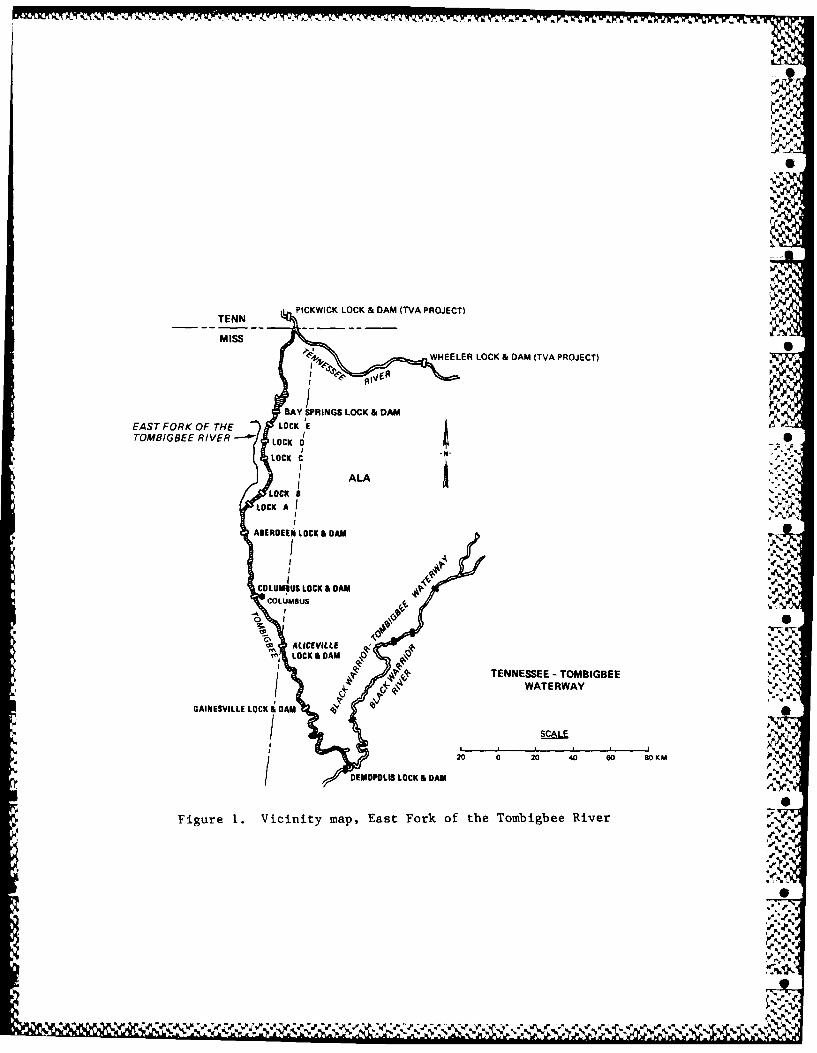
5. From its headwaters in Prentiss and Tishomingo Counties in northeast
Mississippi, the Tombigbee River flows in a southeasterly direction into Ala-
bama. It joins the Black Warrior River at Demopolis and then the Alabama 1River in southern Alabama to form the Mobile River (Figure 1). In December - .
1984, the Tennessee-Tombigbee Waterway, which connects the Tennessee and
Tombigbee Rivers, became operational. The waterway, which includes 10 locks
and dams and a canal, provides a shortened route between the central United
States and the eastern gulf coast. The East Fork of the Tombigbee River orig-
inates at the confluence of Mackeys and Brown Creeks, near river mile (RM) 403
on the waterway (Figure 2b). It flows south through Itawamba and Monroe Coun-
ties and joins the waterway near Amory at RM 366.3 (Figure 2c).
6. The substratum in the lower portion of the river (between Highway 6
and Bull Mountain Creek) consists of pool-riffle habitat with coarse gravel
(D 1 10 mm*). Upstream of Bull Mountain Creek, the river is characterized50 *
by long runs and sediments consisting mainly of fine sands (Dso = 0.25 mm). 5'
Between 1929 and 1980, sediment accumulation at Fulton (the upper section of %
the river) was 5.3 ft (1.615 cm) (USAED, Mobile 1988). The section downriver
of Bull Mountain Creek has experienced little or no sediment accumulation in %
the same period. Both sections of the river have been exposed to the same A
sedimuent inputr-; the lower soction of the river has a higher transport capa- ¢ _
bility. The thalweg slopes of selected portions of the East Fork of the
Tombigbee River are as follows: 2.38 ft/mile (45.3 cm/km) between Town Creek 5,.
and Boguefala Creek, 1.44 ft/mile (27.4 cm/km) between Boguefala Creek and
Bull Mountain Creek, 1.32 ft/mile (25.1 cm/km) between Bull Mountain Creek and
Mantachie Creek, 1.72 ft/,nile (32.8 cm/km) between Mantachie Creek and High-
way 78, and 1.77 ft/mile (33.7 cm/km) between Highway 78 and Walkers Bridge
Road (USAED, Mobile 1988).
7. Prior to completion of the Tennessee-Tombigbee Waterway, the 7-day
3 3at Fulton, MS (57 years of record) was 26 ft /sec (0.736 m /sec). The .".,.%
The diameter of 50 percent of the material is less than 10 mm, and the
diameter of 50 percent of the material is greater than 10 mm. S
'.,,
55

record 1-day low flow was 12 ft 3/sec (0.339 m 3/sec) and the record 7-day low
flow was 15 ft3 /'sec (0.425 m3 /sec). Flow is now augmented in the East Fork of
the Tombigbee River by release structures located in the reservoirs of Locks
A, B, D, and E. These structures (and the volume of water they are designed
to release) are at Mackeys Creek (50 ft 3/sec, 1.416 m 3/sec), Red Bud Creek
(20 ft 3/sec, 0.566 m 3/sec), Mud Creek (20 ft 3/sec, 0.566 m 3/sec), Bull Moun-
tain Creek (100 ft 3/sec, 2.832 m 3/sec), and Turner Branch (20 ft 3/sec,3
0.566 m /sec). It was intended that these structures should release approxi-
mately four times the 7-day Q 10" The release structures at Red Bud and Mud %
Creeks were not operating at the time of the survey. Mud Creek will be used
when a channel is built to carry water to the East Fork of the Tombigbee
River. As soon as the problems of clogging at Red Bud Creek have been solved, V.I
this structure will be operational (Figure 2a). Excess flow in the Tennessee- , ..
Tombigbee Waterway can also be shunted into the East Fork of the Tombigbee
River via spillway structures located at Locks B and E.
Methods
8. A small boat with motor was used to traverse the study area. Shells
were collected by two Individuals at exposed gravel bars and along shorelines.
Intensive searches for live mussels were conducted at sites where fresh shells
were found. Lve mussels were collected by hand in shallow water and by
snorkeling in deeper water. Because visibility was usually less than 15 cm,
live mussels were recognized mainly by touch. The survey was conducted on 2-4
and 9-11 September 1987.
9. Following completion of the survey, the river was divided into nine'.
reaches (Figure 2). This was done to facilitate analysis of data ;indt discus-
sion of results. See Appendix A and Figures 3-6 for information on each river
reach.
6
..= '".
4.-4A%
-. 9

PART III: RESULTS AND DISCUSSION-J %.' .
Community Composition and Distribution 0
10. Approximately 50 species of mussels have been reported from the
Tom),igbee River (Hinkley 1906, van der Schalie 1939, Crossman et al. 1975, '.
.:illiams 1982). At least 34 species have been collected in the East Fork _ 2
between Town and Mill creeks (Schultz 1981, Stansbery 1983a) and are exhibited ..-.
in the Mississippi Museum of Natural Science Mussel Collection, Jackson, MS.
In 1974, J. D. Williams and Randall Grace found abundant mussels below but
very few specimens above Mill Creek.* C. A. Schultz and M. Pierson found
similar conditions in 1980.** Both Williams and Schultz described the upper
reaches as very sandy, with little gravel and very few mussels. Paul D.
Hartfieldt noted similar conditions in 1984 and again in August 1986.-\,.
11. In addition to the exotic Asiatic clam CorbicuZa fZwninea, 28 spe-
cies of freshwater mussels were collected in the East Fork of the Tombigbee
River during this survey (Table 1). Of these, 17 species were found alive,
and 12 species were represented only as shells. Evidence of recent recruit-
ment (i.e. presence of individuals with less than 30- to 40-cm total shell
length) was found for 19 species. It should be noted that many of the species
with no evidence of recent recruitment were also uncommon. It is less likely
to find immature specimens of rare species as compared with abundant species. '.'. .
A recently dead E. penita, listed as endangered by the USFWS (1987), was found
near the mouth of Bull Mountain Creek. This specimen was 68 mm long, and the
valves were in good condition.
12. The greatest number of mussel species, considering live specimens
and shells, was found in Reaches 1 to 6. From 11 to 14 species were collected
in the lower three reaches, and from 16 to 22 species were collected in
Reaches 4 to 6. These lower six reaches, characterized by moderate to steep
gradient and exposed gravel shoals, provided the best habitat for freshwater
Personal Communication, 1987, J. D. Williams, US Fish and Wildlife Ser-vice, Washington, DC.
** Personal Communication, 1988, C. A. Schultz, Mississippi Department ofWildlife Conservation, Amory, MS.Unpublished information, 1986-87, Mississippi Department of WildlifeConservation, Jackson, MS. 0
7
%,4 q >.'
p.. .., 4 ~ %*%% %**~* .'.. '**~** ..-p~x ~ 4 4 * W~ W * ~
WIVi*~~~~~~~~~~1 - ,-. % a =a t= - .
mussels. In Reach 7 two species were collected alive, and seven species were
represented only by shells. In Reach 8 only two species of mussels were
found, and in Reach 9 only C. flwninea (a nonnative bivalve) was collected.
13. Thick-shelled species (Tritogonia verrucosa, Obliquaria reftexa, ,.m
and Quadrula asperata) were abundant to common in Reaches I to 6, the lower
section of the river. Megalonaias gigantea, a thick-shelled species that is
common in large rivers, was abundant only in Reaches 5 and 6. Lwapsilis
crnata, a moderately thick-shelled species, was common to abundant in the
lower six reaches of the river. Potcanilus purpuratus, which has a moderately
thick shell and usually inhabits fine-grained sediments, was rare in the lower
five reaches and uncommon in Reach 6. The most ubiquitous mussel in the river •
was Lampsiiis teres (found in eight reaches), followed by Leptodea fragilis
(found in seven reaches). These two species were the only live mussels col-
lected in Reach 8, which was characterized by sand with little or no gravel.
Both species have relatively thin shells and tolerate sand and fine-grained •
sediments. Thick-shelled species, such as those that were common to abundant
in the lower river, are not usually commcn in fine-grained sediments (Parmalee
1967) .
Endangered Species
14. Five species of mussels recently placed on the Federal List of
Endangered Species (USFWS 1987) [E. penita (Conrad, 1834), P. curtum (Lea,
1859), P. marshalli (Frierson, 1927), P. taitianum (Lea, 1834), and Quadrula
stapes (Lea, 1831)] occur in the Mobile Basin. An examination of historical
records reveals that three of these five species have been reported from the
East Fork of the Tombigbee River. •
15. During 1974, J. D. Williams and Randall Grace collected one
recently dead E. penita and three recently dead P. curtum from the East Fork
of the Tombigbee River just above the Itawamba-Monroe county line (Reach 5).
They also found one complete specimen and one valve of p. curtum about 1 km
below the county line, and 17 recently dead E. penita approximately 2.5 km
below the county line (Stansbery 1983a, 1983b). In 1980, C. A. Schultz and "..
M. Pierson collected six recently dead E. penita and one P. taitianum at a
gravel bar just above the Itawamba-Monroe county line (Schultz 1981).
8% h a'
0 .,.J.
16. In 1984, Paul D. Hartfield, J. D. Williams, and J. Stewart surveyed
the river between the Itawamba-Monroe county line and the confluence of Mill ,
Creek. No endangered mussels were found. In 1986, P. Hartfield surveyed
between Smithville Landing and Mill Creek but did not find any endangered mus- .
sels. In the present survey, a single specimen of E. penita was collected in
the vicinity of Bull Mountain Creek.
17. Based on the results of this survey and those of earlier workers,
the East Fork of the Tombigbee River provides habitat for three species of
endangered mussels. Endangered mussels have been collected in Reaches 5 and
6, between Bull Mountain Creek and the Lock B Spillway Exit Channel. It is
difficult to estimate the total number of living endangered mussels in the
East Fork of the Tombigbee River. However, the authors feel that finding a
fresh shell of E. penita indicates that this species still exists in the
river. Many endangered species are extremely uncommon (i.e. less than I per-
cent of the community); therefore, it is not easy to find live specimens.
Condition of the Existing Mussel Fauna
18. Mussel distribution, abundance and species richness in a river is '
related to the physical conditions of the habitat. A variety of suitable
habitat for mussels exists in the East Fork of the Tombigbee River below the
mouth of Mill Creek (Reaches I to 6). Fresh shells were common along most of
these reaches, and live mussels were locally abundant. Above Mill Creek -
(Reaches 7 to 8), sand and silt accumulations provide marginal habitat for
mussels.
19. Many recently dead mussels were observed between Mill Creek and the
Itawamba-Monroe county line (Reaches 5 and 6). The majority of these were
adults of large species and were either in shallow water or along the margins
of gravel bars. Estimated mortalities, based upon observations made during
this and a previous survey in 1986, were between 50 and 90 percent (Paul D.
Hartfield*). The probable cause of the high mortality in Reaches 5 and 6 is -
the cumulative effect of low water and sediment deposition. Rainfall in the
basin has been lower than normal for the past 4 years. Annual precipitation
* Unpublished information, Mississippi Department of Wildlife Conservation, ....... '
op. cit._ _
9
1
X,
Y -. V % V r 7.
was 50.3, 49.7, 48.3, and 42.8 in. (127.8, 126.2, 122.7, and 108.7 cm), for .".',.
1984-87, respectively, which is less than the 50-year average of 54.6 in.
(138.7 cm) (USAED, Mobile 1988). Reduced water levels caused many mussels to
be stranded on gravel bars and exposed to the drying effects of the atmo-
sphere. As a result of the placement of the five minimum-flow release struc- S.
tures, low-flow augmentation in the East Fork of the Tombigbee River has
alleviated the situation to some extent. The 1985 and 1986 21-day low flows
were greater than that which historically had a 50-percent probability of non-
exceedance. This has occurred despite lower than average rainfall. An exami-
nation of average annual precipitation for the period of record indicates that
extended periods of drought occur at 10- to 15-year intervals in the basin.
20. Accumulations of sediment (5 to 25 cm) were found in deposition
areas in Reaches 1, 2, 5, and 6. Sediment from channelized tributaries in the
western section of the drainage has been entering the East Fork of the Tombig-
bee River since the early 1900s and has caused localized filling of the
floodplain and channel. Typically, these sediments are flushed from gravel .N
bars by periods of high flow, However, the lower than normal precipitation
during the last 4 years has also reduced the incidence of high flows that
typically flush gravel bars of recently settled sediments. An undetermined
amount of mussel mortality could have resulted from deposition of these fine
sediments in the lower river.
21. The Tennessee-Tombigbee Waterway will not appreciably affect the
sedimentation process in the East Fork of the Tombigbee River. An exception
is the reach between the Lock B Spillway Exit Channel and the mouth of Bull -
Mountain Creek (Reaches 5 and 6). Flood flows from Bull Mountain Creek that
originally shaped and sized this channel have now decreased by about 15 per-
cent at the peak. (Actually these flows have now been shifted about 5.4 miles
(8.6 km) downstream and enter the East Fork of the Tombigbee River via theLock B Spillway). Following many cycles of flooding and low flows, this
decrease in flow downstream of Bull Mountain Creek will create a new channel
configuration. The new channel will experience increased aggradation of sedi- .""
ments and a decrease in median grain size of settled particles (USAED, Mobile
S'. .1988).
100
-' %
Effects of Water Removal
22. Water removal for domestic and industrial purposes during normal
low-water periods can expose freshwater mussels to the atmosphere and cause
mortality. However, many species can survive extended periods of exposure
(Simpson 1891; Frierson 1903, 1923; Strecker 1908; Isely 1914; Coker et al.
1921; Haas 1939; Matteson 1955; White 1979). Death of exposed mussels is not
due to desiccation per se, but from the cessation of water currents through
the mantle cavity needed for feeding, respiration, and excretion. Payne and
Miller (in preparation) studied the effects of desiccation on three species of
thick-shelled mussels. Megalonaias gigantea, Q. pustulosa, and F. flava
experienced 12.3-, 5.8-, and 4.6-percent reductions in wet weight and mortali-
ties of 58, 42, and 33 percent after being held for 21 days in dry sand.
Incomplete shell closure by M. gigantea was responsible for its high water
loss. Quadrula pustulosa formed a better seal than did the former species,
and F. ebena had the most complete shell closure. Many thick-shelled riverine .
unionids are virtually immune to water loss when their shell valves are
tightly sealed.
Recommendations % _..
23. The following recommendations are made to assist in the protection
of common and endangered freshwater mussels in the East Fork of the Tombigbee
River. V',
Effects of water removal
24. Any proposed plans for water removal in the East Fork should take
into account the need to protect freshwater mussels. Based upon the technical
literature and experiments conducted by Payne and Miller (in preparation), it St.
is estimated that a 21-day exposure period could cause substantial mortality
(i.e., 33 to 58 percent) in thick-shelled mussels. During periods of low
flow, any water removed from the East Fork of the Tombigbee River should be
augmented by increasing flows at the Lock B and E Spillways.
Determining effectsof increased sedimentation .%..
25. At least four sediment ranges should be established in the section
of the river between the Lock B Spillway and the mouth of Bull Mountain Creek.
. , %
*..,-._,.,, .. ,... %,

These should be monitored annually, and changes in sediment depth should be
correlated to discharge data.
Localized sedimentation
26. At each range, depth of recently deposited sediments should be mea-
sured. Samples should be collected to determine particle size distribution.
Augmenting flow fromrelease structures at Locks E and B
3327. Presently, excessive flow that is less than 1,000 ft3/sec
(28.3 m3 /sec) at Locks E and B is routinely shunted into the canal via exist-
ing bypass structures. If these moderate flows are not required in the water-
way, it is recommended that they be passed into the East Fork of the Tombigbee
River through the existing spillways.
12.
i0
6
S'
''.,re ' - ,, ',"' .3~c'e~C#,,,'' '' #'- ," '," " #' ".""-' "'.' .'',-.''.,".-'"'.)-,-'-;€,,..''. ,'",[ S'
REFERENCES
Coker, R. E., Shira, A. F., Clark, H. W., and Howard, A. D. 1921. "Natural
History and Propagation of Freshwater Mussels," Bulletin of the US Bureau of F
Fisheries, Vol 37, pp 75-182. ..
Crossman, J., Strickler, R. H., Yokley, P., and Gooch, C. 1975. "APreimpoundment Study of Macrobenthos on the River Section of the Tennessee-Tombigbee Waterway," Final Report No. EE-CoE-1862 by Teledyne Brown Engineer-ing, Huntsville, AL, submitted to the US Army Engineer District Mobile,Mobile, AL.
Frierson, L. S. 1903. "The Specific Value of Unio declivis Say," TheNautilus, Vol 17, pp 49-51. .6
• 1923. "Inhabitants of a Natural Aquarium," The Nautilus, Vol 26,pp 126-129.
Fuller, S. L. H. 1974. "Clams and Mussels (Mussels:Bivalvia)," pp 215-273 inPollution Ecology of Freshwater Invertebrates, C. Hart and S. Fuller, eds.,Academic Press, New York and London.
Haas, F. 1939. "On the Life Habits of Some Tropical Freshwater Mussels," TheNautilus, Vol 53, pp 53-56. 0
Hinkley, A. A. 1906. "Some Shells from Mississippi and Alabama," The \%
Nautilus, Vol 20, pp 52-55.
Isely, F. B. 1914. "Experimental Study of the Growth and Migration of Fresh-water Mussels," US Commercial Fisheries Report, 1913, Washington, DC.
Matteson, M. R. 1955. "Studies of the Natural History of the Unionidae,"American Midland Naturalist, Vol 53, pp 126-145."'V
Parmalee, P. W. 1967. "The Freshwater Mussels of Illinois," Popular Science ". %
Series, Vol 8, The Illinois State Museum, Springfield, IL.
Payne, B. S., and Miller, A. C. "Tolerance of Freshwater Mussels to Aerial
Exposure," Miscellaneous Paper in preparation, US Army Engineer Waterways V
Experiment Station, Vicksburg, MS.
Schultz, C. A. 1981. "Tombigbee River Basin Preimpoundment Studies," Missis-sippi Department of Wildlife Conservation, Project F-47, North MississippiFisheries Investigation.
Simpson, C. T. 1891. "On the Means of Distribution of Unionidae in the
Southeastern United States," The Nautilus, Vol 5, pp 15-17.
Stansbery, D. H. 1983a. "The Status of Epioblasma penita (Conrad, 1834) .(Mollusca:Bivalvia:Unionoidea)," Status Survey, Office of Endangered Species,US Fish and Wildlife Service, Jackson, MS.
• 1983b. "The Status of Pleurobema cutun (Lea, 1859) (Mollusca:•Bivalvia:Unionoidea)," Status Survey, Office of Endangered Species, US Fish .and Wildlife Service, Jackson, MS.
Strecker, J. K., Jr. 1908. "The Mollusca of McLennan County, Texas," TheNautilus, Vol 22, pp 63-67.
13
'4"' '"N
US Army Engineer District, Mobile. 1988. "Final Report: Tombigbee River(East Fork) Study; Attachment 1: Freshwater Mussel Habitat Investigation,"Mobile, AL.
US Fish and Wildlife Service. 1987. "Endangered and Threatened Wildlife and 6
Plants," Federal Register, 10 April 1987, 50 CFR 17.11 and 17.12.
van der Schalie, H. 1939. "Medionidu mcglameriae, a New Naiad from theTombigbee River, with Notes on Other Naiads of That Drainage," OccasionalPapers of the Museum of Zoology, University of Michigan, Vol 407, pp 1-6.
White, D. S. 1979. "The Effect of Lake-Level Fluctuations on Corbicula andOther Pelecypods in Lake Texoma, Texas and Oklahoma," Proceedings of the FirstInternational Corbicula Symposium, pp 82-88.
Williams, J. D. 1982. "Distribution and Habitat Observations of SelectedMobile Basin Unionid Mollusks," pp 61-85 in Report of Freshwater MollusksWorkshop, A. C. Miller, compiler, US Army Engineer Waterways Experiment Sta-tion, Vicksburg, MS.
1- J.@
. .',.
N 'I149

Table 1
Bivalves Collected from the East Fork of the Tombigbee River, Monroe
and Itawamba Counties, Mississippi, September 1987
Species Condition* Recruitment**
Amblema plicata (Say, 1817) L YArcidens confraqosus (Say, 1829) 5 YEliptio arctata (Conrad, 1834) S NE7liptio crassidens crassidens (Lamarck, 1819) L NEllipsaria lineolata (Rafinesque, 1820) S YEpioblasma penita (Conrad, 1834) S NFusconaia cerina (Conrad, 1838) L YFusconaia ebena (Lea, 1813) 5 NLampsiliis ornata (Conrad, 1835) L YLainpsitis stramninea cZaibornensis (Lea, 1834) L NLcwrsilis teres (Rafinesque, 1820) L YLasmigona conrplanata (Barnes, 1823) L YLeptodea f'raqilis (Rafinesque, 1820) L YLigumia recta (Lamarck, 1819) 5 NMegalonaias qiqantea (Rafinesque, 1820) L YObZiquaria reflexa (Rafinesque, 1820) L Y-0Obovaria unicolor (Lea, 1845) 5 YPlectomerus dombeyanus (Valenciennes, 1833) L NPleurobema decisum (Lea, 1831) 5 NPotamilus purpuratus (Lamarck, 1819) 5 YQadruia asperata (Lea, 1861) L YQuadruia runrphiana (Lea, 1852) L YvStrophitus subvexus (Conrad, 1834) 5 NToxolasma parvus (Barnes, 1823) L YTritogonia verrucosz (Rafinesque, 1820) L YTruncill-a donaciformis (Lea, 1828) L YVillosa Zienosa (Conrad, 1834) 5 NVillosa vibex (Conrad, 1834) 5 YCorbicuta flwninea (Muller, 1774) L Y
Total species of bivalves =29Total species collected alive =17Total species exhibiting evidence of recent recruitment =19
*Condition: '8
L - collected alive.S - collected as shells only.
**Recruitment:
Y - evidence of recruitment.N = no evidence of recruitment.
w
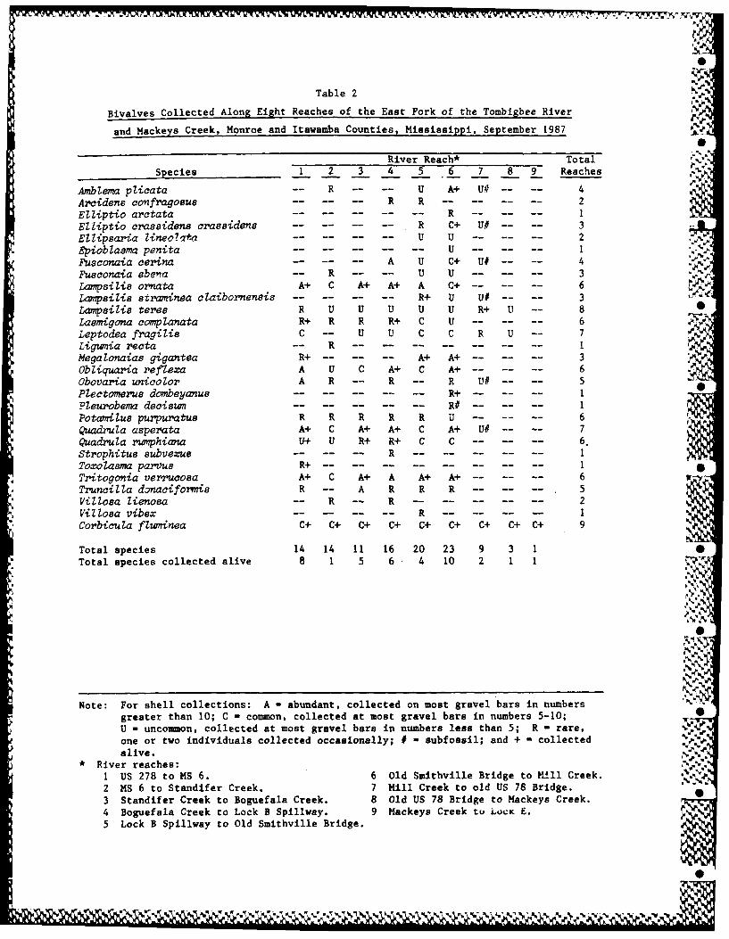
Table 2 .4.
Bivalves Collected Along Eight Reaches of the East Fork of the Tombigbee River
and Mackeys Creek, Monroe and Itawamba Counties, Mississippi, September 1987
River Reach* Total
Species 1 2 3 4 5 6 7 8 9 Reaches
Amblema plicata -- R -- -- U A+ U# -- 4 4Arcidens confragosue -- R R ---------- 2Elliptio arctata .. .. .. ..- R -- .-- .--Elliptio crassidens crassidens .. .. .. ..- R C+ U# .. .. 3Ellipsaria Zineoa*,.. U U- .. .. .. 2Epiobiasma penita U .. .1Fusconaia cerina A U C+ U# . . 4Fusconaia ebea -- R - -- U U .. .. .. 3
Lampsilieornata A+ C A+ A+ A C+-.. .. .. 6- --Lampsilis straminea claibornensis .. .. .. ..- R+ U U# .. .. 3Lampsilis terse R U U U U U R+ U -- 8Lasmigona complanata R+ R R R+ C U- .. .. .. -6 Leptodea fragili8 C -- U U C C R U - 7Ligumia recta -- R --.-- ----- -- -- I
Megalonaias gigantea R+ .. .. ..- A+ A+-.. .. .. 3Obliquaria reflexa A U C A+ C A+-.. .. .. 6Obovaria unicolor A R R - R U# .. .. 5Plectomerus dombeyanus -- R+----------1Ple robema deciswn .. .. .. .. .. R# .. .. .. -1Potamilus purpuratus R R R R R U- .. .. .. 6
Quadrula asperata A+ C A+ A+ C A+ U# . . 7Quadrula rwnphiana U+ U R+ R+ C C .. .. ..- 6.Strophitus aubvexue R---- -.. .. .. 1Toxolasma parvus R+ --------------- 1 •
Tritogonia verrucosa A+ C A+ A A+ A+-.. .. .. 6Truncilla donaciformis R -- A R R R- .. .. .. 5illosa lienosa R R -- ---------- 2
Villosa vibex R -------- --Corbicula fluminea C+ C+ C+ C+ C+ C+ C+ C+ C+ 9
Total species 14 14 11 16 20 23 9 3 1 0Total species collected alive 8 1 5 6 4 10 2 1 1
Ilk
Note: For shell collections: A - abundant, collected on most gravel bars in numbersgreater than 10; C - common, collected at most gravel bars in numbers 5-10;U - uncommon, collected at most gravel bars in numbers less than 5; R - rare,one or two individuals collected occasionally; # - subfossil; and + - collectedalive. "'
River reaches:
1 US 278 to MS 6. 6 Old Smithville Bridge to MIll Creek. '
2 MS 6 to Standifer Creek. 7 Mill Creek to old US 78 Bridge. .___3 Standifer Creek to Boguefala Creek. 8 Old US 78 Bridge to Mackeys Creek. 04 Boguefala Creek to Lock B Spillway. 9 Mackeys Creek to LocK E.
5 Lock B Spillway to Old Smithville Bridge.
!0
('4*. .0
PIWI LOCK & DAM (APOET
WHEELE LO&DM(TAPOET
BAYK 8PIG OCEASTORK THE LOCKE
ALA
ABERDEEN LOCK & DAM.
COUBSLOCK S DAM %
TENNESSEE - TOMBIGBEE/ WATERWAYGAINESVILLE LOCK &DAM '
20 0 20 40 6 80 KM
DEMOPOLIS LOCK & DAM
Figure 1. Vicinity map, East Fork of the Tombigbee River
-N
4F.~
%
1p% p

SCALE mfs
0 1 2 KM Mi. 410
M IS S IS S I I,.- f ;CREEK. cEE
SAUCER"
.. PRNTISSCOUNTCREEKl
i ~-. t
WAT E WABYCOUNTY, 4
-o-
L~a Pool E
Figre .eacesseachd fr ussel]s onthe East Fork of the Tombigbee
River, Monroe and Itawamba Counties, Mississippi, September 1987
... .. .TE NESE - TOMBIGBEE , ) . , i,(Sheet 1 of 3)
40
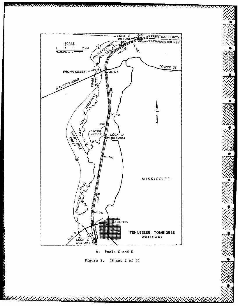
----- LOCK E * PENTISS COUNTY
SCAL MIL 4O~. A.ITAWAMBA COUNTYSAE9
rcqp0 1 2KM
O4'.
cl,~~~1 7-AL .9.
k .
%
MISSISSIPPI
4'4
'4--..'.
Figure~~~*N 2. (he .f3
V4*~

L OCK CMILE 391.0TO
SCALE -
0 1 2KM
MANTACHIE 0CREEKN
M. 385
0
MississIipi3~ /.MILL CREEK "
BULL MOUNTAINCREEK
SMITH VILLE "
ITAWAMBA COUNTY BRIDGE - "
MONROE COUNTY 4
*, -" S ,
BOGUEFALA CREEK SMT\ILL ,
LOCK 8 SMITVILLMILE 376.3
CREEK E CEE
* "
TURNER BRANCH r--
• -S,..-,.
de'.
F~gure2. (Seet53 f.3)
2S
.,,,,, .. .,,
TENNESSEE - TOMBIGBEE367 WATERWAY
C. Pools A and B pp
Figure 2. (Sheet 3 of 3)
5%S
.5!%-.. ., 7mm %,,+ " "'w. .P w ,, +. ' "."" ",. ". -I' " k . . . . +.. ",,,- , - - - -#. . . . -,-'.,,,% %

- V - -: -" .-. ~ ~t ~ 0 ,q.. ~ - -
0%
~ A
0*
SN 4
-p
A0
0%
~00 *~. ~
0~~
--- 0%.'9 -- - - -%
S.4.
~0%
0%* St N
S
"'fl.
Figure 3. A sand and gravel operation was observed inReach 3
SWA
Jo
'Jo
N'
*0 O5
A' ~~0%A'
Yb
dvV.
pS4.'
I01
No '0 %
I Figure 4. A very productive gravel bar was found in Reach 5,below the Smithville Bridge
*54.0
0%
A' "N?of. 9b..5
00~------- 0 0 *~o ~A A A* *5 N N >YVV't.~..V' A~9b'0'0 ~?;tt~

~!h.YE
V
NS
V
4..~* ,
4.
4.
S..
(..
Figure 5. An exposed gravel bar in Reach 6
S.
4.4.4.
I
* 4.* 4.4.
.4 4.I,. - *%
S
*db *~4
I-..4.-.'I.-.
S
I,
.5.
.5.
*.5%~
Figure 6. Moderate currents, sand substratum, and lack ofexposed gravel bars characterized Reach 8 0
4.. 4.V.~w.
5 .lS.~.
APPENDIX A: STUDY SITES ON THE EAST FORK OF THE TOMBIGBEE RIVER
1. Mussels were collected in nine reaches of the East Fork of the
Tombigbee River (Figure 2*). Characteristics of each reach are described
below. .M•
Reach 1: US 278 to Highway 6
2. Between the US 278 Bridge and the entrance of Town Creek, the river
was wide and deep (>2 to >3 m), and the current was less than 30 cm/sec. The
first exposed gravel bars were found upriver of Town Creek. Between Town
Creek and Highway 6, gravel bars were long and narrow and located in river 0
bends. The current was moderate (30 to 50 cm/sec) over the bars and usually
less than 30 cm/sec adjacent to the gravel bars. Substrata consisted of sand
and gravel in the bends and mud along the banks. Many shells were found in Vmuskrat middens, and live mussels were found in runs (depth >1.0 m) and on the
outside of bends where currents kept the gravel sediment free.
Reach 2: Highway 6 to Standifer Creek
3. This reach of the river was mainly pool-riffle habitat, with gravel
bars in the bends and mud in depositional areas. The current was swift "t0
(>50 cm/sec) over the shoals and moderate (>25 cm/sec) in other reaches. Only
a few shells were encountered, and no live mussels were found.
% 4. Immediately upriver of the Highway 6 Bridge, a gravel operation had
used a dragline to remove gravel from the main river. Fresh shells were found
in the dredged material.
Reach 3: Standifer Creek to Boguefala Creek
5. Many large gravel and sand bars were in this section of the river.
% The effects of gravel removal were noted at three or four of the bars (Fig- -
ure 3). Many fresh shells and a few live mussels were on a gravel shoal about
* See figures at the end of the main text.
Al ..
6* % v "'~ . ~
3.2 km upstream of Standifer Creek. This was the only site in this reach
where live mussels were found, although shells were common.
SReach 4: Boguefala Creek to Lock B Spillway
6. Many shells in muskrat middens and a few live mussels were found at
the first gravel riffle about 2 km upriver of Boguefala Creek. Shells were
found upriver of this shoal. Fine-grained sediments had settled in deposi-
tional areas. Water velocity was high (>50 cm/sec) in the bends and moderate
(25 to 50 cm/sec) in the runs.
Reach 5: Lock B Spillway to Old Smithville Bridge
7. The lower section of this reach was similar to Reach 4. No live
mussels were found, although shells were common on exposed gravel bars. Near
river mile (RM) 278, many fresh shells were found on a large gravel bar that
constricted the channel (Figure 4). Live mussels were collected on the
upriver portion of the bar. Live mussels were found between this gravel bar
and the Smithville Bridge. Current in the upper section of this reach was
moderate (25 cm/sec), and substrata consisted of sand, gravel, and fine-
grained sediments in depositional areas. With the exception of occasional .-..
deep holes, water was I to 2 m deep.
Reach 6: Old Smithville Bridge to Mill Creek
8. In this reach, the river was narrow, and water velocity was high
(>75 cm/sec) over shoals, around gravel bars (Figure 5), and in the bends.0
Thick deposits of mud were often noted in depositional areas. Many mussels
and fresh shells were found along the peripheries of the bars. A few mussels V.:
were found along these bars, but a significant portion of the population had
recently died. Most of the recently dead individuals were adults.
Reach 7: Mill Creek to Old US 78 Bridge 'A.
9. This reach of the river was narrow, shallow, and meandering, with
stable mud banks, small sandbars, and mud and sand substratum. The only
A2
0
% -V ~ ~ V '~
gravel bars in this reach were above the channelized section of the river
(between RM 384 and 385). Small patches of gravel were often covered with
recently deposited mud and sand. Subfossil shells were found on the gravel
bars, but no live mussels or fresh shells were collected. Live mussels ... .
included the yellow sand shell (Lampsilis teres) and the Asiatic clam
(Corbicula fluminea). The channelized portion was shallow (<0.5 m) with a
clay and mud bottom. Mantachie Creek, which is channelized, appears to
deposit a heavy sediment load into this reach.
Reach 8: Old US 78 Bridge to Mackeys Creek V..
10. This reach had well-defined narrow banks and many meanders. Sub-
stratum consisted of mud and sand, with accumulations of sand below channel-
ized tributaries (Figure 6). Snags and natural obstructions had formed deep
holes in some bends. A desnagging crew was clearing the channel. No live
mussels and only a few shells were found.
Reach 9: Mackeys Creek to Lock E
11. Mackeys Creek was very narrow* well defined, meandering, with mud
and sand substratum. Hard clay and rocky outcrops formed shoals in the vicin-
ity of Lock E. Asiatic clams were common to abundant In depressions in these ,
shoals. No live mussels or shells were collected.
%
A3* Ak%