for the new find my school bus stop - school district of ... guide for the new find my school &...
TRANSCRIPT

1
Guide for the New Find My School & Bus Stop
The PBCSD Department of Transportation, in conjunction with the Department of Real Estate & Intergovernmental Relations, is excited to announce the release of several new and improved online features to help students and parents not only find their school, but provide help in getting to school too!
It is the intention of this guide to provide users thorough but brief instructions on utilizing the improved legacy features, as well as acquaint the user to the new features.
The new “Find My School & Bus Stop” website combines the existing features of the legacy Find My School web application with new features for identifying the closest bus stop for those students who are eligible for Transportation. Additionally, the ability to register students for Transportation, and the ability to track the bus for the route your student is on, is explained below. This guide will provide step‐by‐step instructions for the following features:
1. Find the zoned school for any address 2. Find the zoned school for a new development 3. Find the zoned schools for any point in Palm Beach County 4. Find the closest bus stop from my address 5. Find the closest bus stop from my address for a Choice School 6. Register my student for transportation at the closest bus stop to my address 7. Track the bus for the route my student is on 8. View Attendance Zone, Walk Zone and Potential Hazardous Area 9. View the Public Officials for your address, and provide contact information for these Officials

2
1. Find the zoned school for any address a. To find the schools zoned for an address in Palm Beach County go to FindMySchool.info

3
b. In the Boundary Information window, next to Address, enter the address for which you want to find zoned schools, then select the Search button.
c. Select the address from the results. There may be multiple options due to homes in the unincorporated county having various mailing addresses. The actual location is the same for addresses that have the same zip code, and the zoned schools will be the same. Select the magnifying glass icon
next to the address that you want to see the zoned schools for. The SAC number and zoned schools will appear in the window. (see below)
4
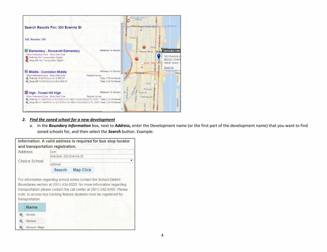
2. Find the zoned school for a new development a. In the Boundary Information box, next to Address, enter the Development name (or the first part of the development name) that you want to find
zoned schools for, and then select the Search button. Example:
5
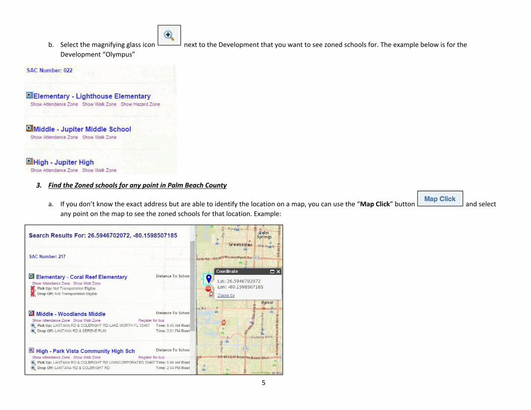
b. Select the magnifying glass icon next to the Development that you want to see zoned schools for. The example below is for the Development “Olympus”
3. Find the Zoned schools for any point in Palm Beach County
a. If you don’t know the exact address but are able to identify the location on a map, you can use the “Map Click” button and select any point on the map to see the zoned schools for that location. Example:

6
4. Find the closest bus stop from my address for a Choice School a. When you enter an address in the Boundary Information window, the information returned with the zoned school also includes the distance from
the address to the school. If your address is more than 2 miles from the school, you are eligible for transportation and the closest bus stop will be shown. Example:

7
5. Find the closest bus stop from my address for a Choice School a. After you enter your address and the zoned school information appears, you can select the attending Choice School from the drop down list to the
right of the text “Choice School”.
Make you selection from the list of schools featuring Choice programs, and then select the Search button. Example:

8
b. The program returns the list of addresses again. Select the address that you want to find the closest bus stop for by clicking the magnifying glass
icon. Example:
c. The closest bus stop will be displayed for that Choice School. 303 Evernia St, West Palm Beach, FL, 33401 was selected for this example as well as BAK Middle School of the Arts. Example:
6. Register my student for Transportation at the closest bus stop to my address
Benefits of registering your student for Transportation include the ability to track your child’s school bus in real time. Additionally, registration helps Transportation Administrators plan more effectively, and reduce the chances of overcrowded buses.
a. In the Boundary Information window, when a bus stop is indicated for a school associated with your address, you now have the opportunity to register your student for Transportation directly from this website. See below for example of Conniston Middle and Forest Hill High.

9
b. Select the text “Register for Bus” . You will be asked to register for AM or PM (you will be able to register for both on the form if you would like). Once you select AM or PM the registration form will pop up.

10
c. You will have to enter the student ID and then the student’s date of birth to fill out the form for Grades 1 – 12. If you are registering a Kindergarten student you will not need a student ID. Follow the directions in the form and check the “I agree Box”. The student is now registered for Transportation at that bus stop.

11
7. Track the bus for the route my student is on
a. Using the same schools as the previous example, you will see that for Conniston there is also a route number listed to the right of the bus stop.
b. If your student is registered, you can track the bus from this link. Click on the text for the route number (C123 in the example above) and a form will appear. Again you will have to enter the Student ID and date of birth for the password to access the Bus Tracking feature.
8. View Attendance Zone, Walk Zone and Potential Hazardous Area a. In the Boundary Information window, after you have entered an address you can click on any of the text that appears, such as Show Attendance
Zone, Show Walk Zone and/or Show Hazard Area to see the areas on the map. Example:

12
Example of walk zone:
9. Viewing & Connecting with Public Officials a. On the bottom of the Boundary Information Window, after you have entered an address there will be a list of public officials for that address.