for sale 430 west pike street, lawrenceville, ga 30046...apr 05, 2018 · attractive, one-story,...
TRANSCRIPT

FOR SALE
430 WEST PIKE STREET, LAWRENCEVILLE, GA 30046
Presented by:
Angela Moore 404-816-1600, ext. 131
c) 404-514-0664 [email protected]

430 W. Pike Street
Lawrenceville, GA 30046
Table of Contents
I. Executive Summary ◦ Demographic Summary ◦ Traffic Count Summary ◦ Flyer/ Aerial/ Survey
II. Location Map ◦ Proximity to Gwinnett Medical Center Lawrenceville and Briscoe Field Airport ◦ Subject Property Photographs
III. Lawrenceville Redevelopment Plan ◦ Lawrenceville Redevelopment Map ◦ Atlanta Journal Constitution Articles
IV. Gwinnett County Transit ◦ Plans for Gwinnett County Transit
V. Proforma- Jan 2020 Rent Roll- Jan 2020
VI. Tax Assessment Property Report
VII. Zoning ◦ BG- General Business ◦ Zoning Map
VIII. Demographics ◦ Traffic Count Report ◦ Traffic Count Map

Address: 430 West Pike Street Lawrenceville, Georgia 30046 Gwinnett County Attractive, one-story, stone, and glass retail/office building. Best suited for owner occupancy or investment. Excellent visibility. Monument signage at entrance and street level. Within walking distance to Mixed-Use Mega Project planned for Downtown Lawrenceville.
Building Size/Acres:
Building Size: 4,600 Square feet Acres: 24,829 square feet / .58 Acres
2018 Taxes:
$7,203.00
Price: $750,000.00/$163.05 PSF
Occupancy/ Availability:
75% Suite A: 2,100 SF Available for Lease Rate: $19.00 PSF, NNN
Year Built: Year Renovated:
2002 2019
Construction: Masonry (construction plans available upon request)
Parking:
25 Spaces
Frontage: 194 feet along West Pike Street
Traffic Count: GA Hwy 120 /West Pike Street: 44,464 cars per day (see summary on following page)
Zoning: BG- General Business
Tenant List: Vacant: 2,100 SF Paige Beni Photography: 1,250 SF TrendiEmage Hair Salon: 1,250 SF
430 W. Pike Street Lawrenceville, GA 30046
Executive Summary

430 W. Pike Street Lawrenceville, GA 30046
Collection Street Cross Street Traffic Vol Year Distance
W Pike St Buchanan St NW W 44,640 2016 0.03 mi
W Pike St Langley Dr E 44,370 2016 0.22 mi
Langley Dr Huff St NW 13,160 2016 0.35 mi
W Pike St Honeysuckle Cir W 20,972 2016 0.36 mi
Duluth Hwy 120 John B Wilson Ct NW 35,719 2015 0.41 mi
1 Mile 3 Mile
Population 6,178 76,830
Households 2,476 25,772
Average Age 34.20 34.40
Median HH Income $35,352 $55,711
Daytime Employees 27,269 54,456
Population Growth '17-'22 ↑8.1%
↑9.5%
Household Growth '17-'22 ↑8.0%
↑9.4%
Demographics Summary
Traffic Count Summary

430 W. Pike Street Lawrenceville, GA 30046
Location Map
430 W. Pike Street
Gwinnett Medical Center, Lawrenceville
Briscoe Field Airport
Downtown
Lawrenceville
Mega Mixed Use
Development
Project

430 W. Pike Street Lawrenceville, GA 30046
Subject Photo

430 W. Pike Street Lawrenceville, GA 30046
Subject Photo

430 W. Pike Street Lawrenceville, GA 30046
Subject Photo

430 W. Pike Street Lawrenceville, GA 30046
Subject Property Proximity to Major Locations in Gwinnett County
• 430 West Pike Street is in close proximity to a major hospital and airport in Gwinnett County. It is also located one mile from GA 316, a major East/West traffic artery connecting Athens to Atlanta. • The subject is located less than one mile from a major hospital. As the flagship hospital, Gwinnett Medical Center–Lawrenceville is more than just a full-service hospital featuring the latest medical technology and treatments. Located in the heart of Gwinnett, Gwinnett Medical Center–Lawrenceville is accessible from areas across north metro Atlanta via I-85 and GA-316. Gwinnett Medical Center–Lawrenceville offers nationally recognized and renowned services at several facilities on campus. • The subject is located 2.5 miles from the County Airport Briscoe Field. Gwinnett County Airport is located on approximately 500 acres northeast of the city of Lawrenceville. The airport has a single 6,000-foot-long by 100-foot-wide grooved asphalt runway, capable of handling all light general aviation aircraft and most corporate jet aircraft in operation today. Gwinnett County Airport is serviced by two Fixed Base Operators (FBOs). Gwinnett Aero is located on the north side of the field and Aircraft Specialists Jet Center is located on the south side. The airport has an Air Traffic Control Tower that is in operation from 7:00 am to 9:00 pm year-round. At the airport, there are more than 50 aviation-related tenants, almost 200 hangars, and about 300 aircraft that are based there.
• Located directly on GA-120, a major East-West artery connecting Gwinnett, North Fulton, Cobb and Paulding counties • Highly visible with direct road frontage and lighted marquee signage.

430 W. Pike Street Lawrenceville, GA 30046
Mixed Use Mega Project Planned for Downtown Lawrenceville The development, which will go up on about 35 acres just south of the Gwinnett County seat’s downtown square, is slated to include about 15,000 square feet of commercial space in addition to apartments, townhomes, detached homes and “age-targeted” residences. Officials believe the $200 million project is the largest redevelopment project in Gwinnett County, if not all of suburban Atlanta. The new renderings — which can be seen below — were released by developer Novare Group during a Monday evening meeting of the Lawrenceville planning commission. 430 W. Pike Street is approximately 1 mile NE of this project.
Site plan of the $200 million mixed-use, “urban-style” development planned near downtown Lawrenceville.
Updated Nov 23, 2017 By Tyler Estep, The Atlanta Journal-Constitution
430 W. Pike Street Lawrenceville, GA 30046
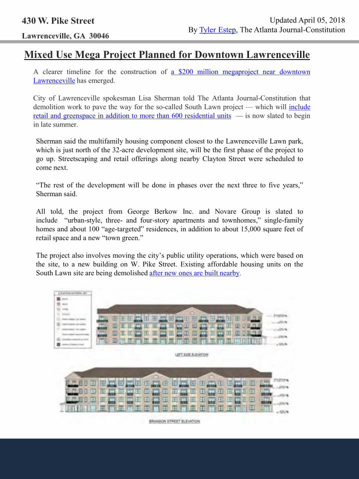
Mixed Use Mega Project Planned for Downtown Lawrenceville A clearer timeline for the construction of a $200 million megaproject near downtown Lawrenceville has emerged. City of Lawrenceville spokesman Lisa Sherman told The Atlanta Journal-Constitution that demolition work to pave the way for the so-called South Lawn project — which will include retail and greenspace in addition to more than 600 residential units — is now slated to begin in late summer.
Updated April 05, 2018 By Tyler Estep, The Atlanta Journal-Constitution
Sherman said the multifamily housing component closest to the Lawrenceville Lawn park, which is just north of the 32-acre development site, will be the first phase of the project to go up. Streetscaping and retail offerings along nearby Clayton Street were scheduled to come next. “The rest of the development will be done in phases over the next three to five years,” Sherman said. All told, the project from George Berkow Inc. and Novare Group is slated to include “urban-style, three- and four-story apartments and townhomes,” single-family homes and about 100 “age-targeted” residences, in addition to about 15,000 square feet of retail space and a new “town green.” The project also involves moving the city’s public utility operations, which were based on the site, to a new building on W. Pike Street. Existing affordable housing units on the South Lawn site are being demolished after new ones are built nearby.

430 W. Pike Street Lawrenceville, GA 30046
Mixed Use Mega Project Planned for Downtown Lawrenceville
Updated April 05, 2018 By Tyler Estep, The Atlanta Journal-Constitution
New renderings were released Monday of the megaproject being planned for downtown Lawrenceville. (City of Lawrenceville/Novare Group) More renderings released for megaproject near downtown Lawrenceville

430 W. Pike Street Lawrenceville, GA 30046
Gwinnett County Transportation Press Release
A A
For one of the first times since its inception in 2001, Gwinnett County Transit has initiated a Comprehensive Transit Development Plan to review all fixed route and paratransit services. The Connect Gwinnett planning team has developed draft recommendations for short-, medium- and long-term plans for identified current and future funding sources. In order to vet these plans through a broad community outreach effort, the team has held public open houses across the county and is now conducting an online survey and a scientifically valid phone survey. Take the 10-minute Gwinnett County Transit survey about the future of public transportation in Gwinnett. Information provided will help the Connect Gwinnett planning team understand the needs of Gwinnett residents and business owners.
Updated May 7, 2018, By Karen Huppertz, For the AJC
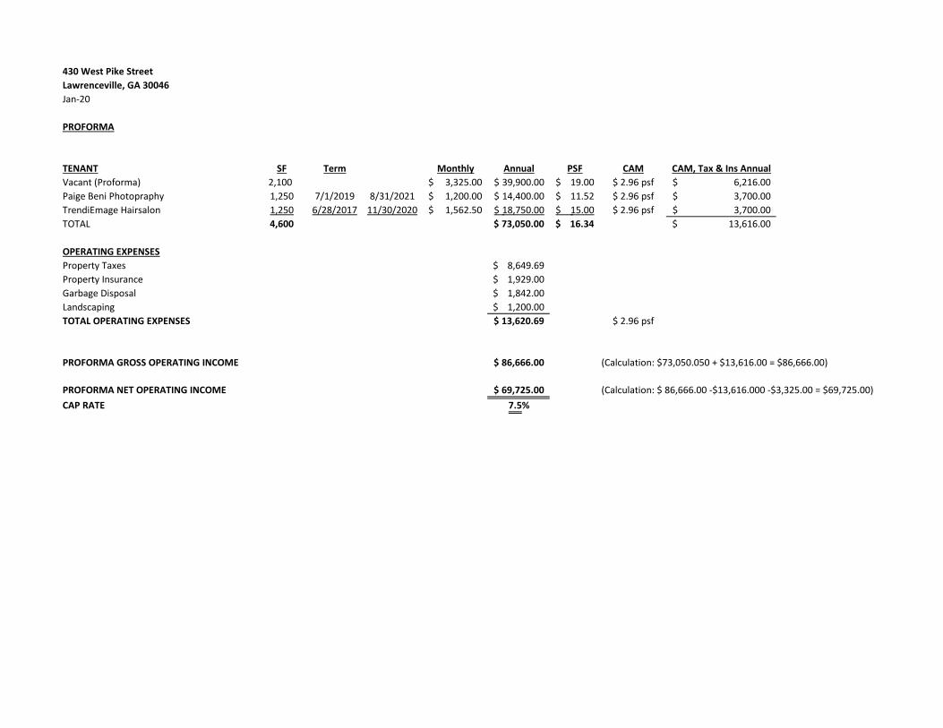
430 West Pike Street
Lawrenceville, GA 30046
Jan-20
PROFORMA
TENANT SF Term Monthly Annual PSF CAM CAM, Tax & Ins Annual
Vacant (Proforma) 2,100 3,325.00$ 39,900.00$ 19.00$ $ 2.96 psf 6,216.00$
Paige Beni Photopraphy 1,250 7/1/2019 8/31/2021 1,200.00$ 14,400.00$ 11.52$ $ 2.96 psf 3,700.00$
TrendiEmage Hairsalon 1,250 6/28/2017 11/30/2020 1,562.50$ 18,750.00$ 15.00$ $ 2.96 psf 3,700.00$
TOTAL 4,600 73,050.00$ 16.34$ 13,616.00$
OPERATING EXPENSES
Property Taxes 8,649.69$
Property Insurance 1,929.00$
Garbage Disposal 1,842.00$
Landscaping 1,200.00$
TOTAL OPERATING EXPENSES 13,620.69$ $ 2.96 psf
PROFORMA GROSS OPERATING INCOME 86,666.00$ (Calculation: $73,050.050 + $13,616.00 = $86,666.00)
PROFORMA NET OPERATING INCOME 69,725.00$ (Calculation: $ 86,666.00 -$13,616.000 -$3,325.00 = $69,725.00)
CAP RATE 7.5%

430 West Pike Street
Lawrenceville, GA 30046
4,600 RSF
Jan-20
Rent Roll
Square Rent Monthly Annual
Tenant Footage PSF Rent Rent CAM
Suite A Vacant (Proforma) 2,100 19.00$ 3,325.00$ 39,900.00$ $2.96 psf
Suite B Trendi Image Hair Salon 1,250 12/1/2017 11/30/2020 15.00$ 1,562.50$ 18,750.00$ $2.96 psf
Suite C Paige Beni Photography 1,250 7/1/2018 8/31/2021 11.52$ 1,200.00$ 14,400.00$ $2.96 psf
73,050.00$
CAM: $2.96 PSF
Escalation: 3%
Term

RIV
ER
DALE CRES
T
CHANDLER ROAD
BU
FO
RD
DR
LAWR
ENCEVILLE
SUW
ANE
E R
OA
D
LA
WRENC
EVIL
LE SU
WA
NE
E R
OA
D
MO
NF
OR
T R
OA
D
LAKES PARKW
AY
PRO
VIDEN
CE W
AY
PROVIDEN
C
E WAY
RIVER
S IDE PARKWAY
MC
CA
RT
RO
AD
REG
AL DR
REG
AL DR
WATER
CR
EST
CIR
WATERCREST CIR
WAYSIDE DR
WAYSIDE DR
PARK
PL
DR
PARK PL DR
SUNDALE DR
SUNDALE DR
BOW
MAN
ROAD
SUMMIT RIDGE DR
S UMMIT RIDGE DR
LEACH DR
LEACH
DR
JOH
NS
ON
RO
AD
FOREST PL
FORE
ST PL
DOW
NEYS
HIR
E D
R
DOWNEYSHIRE DR
DAV
IS R
OAD
DAV
IS R
OAD
MEP
HISTO CIR
CANTERBURY LN
CANTERBURY LNCH
ARLE
STO
N LN
CHARLESTO
N LN
STONE
MILL
RUN
STONE MILL RUN
CEDA
R RID
GE
TRAIL
CEDAR RIDGE TRAIL
HI-
HO
PE
RO
AD
HI- H
OP
E R
OA
D
PIN
E F
OR
ES
T D
R
P I NE
FOR
ES
T D
R
DANIEL
LN
DANIEL LN
FIRST ST
CEDARHURST ROAD
DRAYTO
N M
ANOR
RUN
WIM
BERLY
WA
Y
PARC RIVER BLVD
PARC RIVER BLVD
CLARIDGE LN
LIVERY CIR
LIVERY
CIR
SIMONTO
N
CREST
DR
CEDARS RO
AD
MAPLEW
OO
D D
R
JAM
ES R
IDG
E D
R
DOG
WO
OD
PAR
K DR
CHANNINGS LAKE D
R
RALEIGH WAY
RALEIGH
WAY
SPRIN
GBO
TTO
M DR
JOHN'S LANDING WAY
SHOAL C IR
SHOAL CIR
MILLE NI AL LN
SU
MM
ER
VIL
LE D
R
LAWRENCEVILLE IND PARK
CIR
Georgia Highway 316
Georgia Highway 316
BRID
LE P
ATH
DR
APPIAN
WAY
AP
P
IA N WAY
CO
T TONPATCH
ROAD
MADISON CHASE DR
WI ND
SOR
BROOK L N
WINDSOR BROOK LN
REBEC
CA
ST
REBECCA ST
HILLCREST G
REEN
DR
GRAYLAND HILLS DR
TANNERS PT DR
TANN
ERS PT DR
PE
T TY
RO
AD
PET
TY RO
AD
SARAH LN
CIT
Y LAKE
OAK STOA
K S
T
BROO
KVIEW TR
AIL
JACKSON ST
KESWICK
PL DR
TOW
NE PARK DR
TOWNE PARK DR
POST HORN RUN
COO
L
WEATHER DR
FAIRVIEW TRAIL
LEWIS RIDGE
CIR
LEWIS
RIDG
E
CIR
RUSSELL RIDGE DR
MEDITERRANEAN LN
ASHLAN
D PARK
WAY
VILLAGE W
AY
VILLAGE WAY
MC
KEN
DR
EE LAK
E D
R
HA NARRY DR
HILLARY LN
A SHLEY LAINE WALK
COLO
NY
CR
EE
K DR
CONGRESS
PARKWAY
COOPER W
AY
SUNSET
RIDGE
LN
BE
NS
ON
ST
BEN
SO
N ST
HUNTERS RIDGE D R
MO
RNINGSIDE DR
WIN
DALE DR
WINDALE
DR
MERRITT
DR
ME
RRITT DR
KENIMER PL
KENIMER
PL
MERCURY DR
TRAVERS CIR
HEL ENS MANOR DR
FERNSTONE TRAIL
LANGLEY DR
STAMPM
ILL W
AY
BO
WM
AN R
OA
D
PATT
ERSON
PARK DR
SHERWOOD DR
L
A NCASTER CLOSE
S K IDMORE
CIR
SIMON
IVE DR
FAIRFAX
PL
FAIRFAX PL
HUNTERS COVE
DR
BLAIR CIR
AMELIA
GAR
DEN W
AY
M ELODY
LN
MELODY LN
PATTERSON CT
JOSH LN
RUSTIC RIDGE CIR
A DAMS
LAK
E D
R
ASHBROOK DR
EDG
ELEY
LNCASTLEBR
OO
KE D
R
FIELDSTREAM W
AY
ALCO
VY HILLS
DR
LAKE ROAD
LAKE
ROAD
RAC
K RO
AD
BRIA
RHURST C
T
W
OODHAVEN DR
CHANDL ER ROAD
OLD JOHN SO N ROAD
TIMBERCREST DR
SEABOARD IND
BEDFORD BAY
LN
CHASE W
ALK LN
WEST BLAZING RIDGE
ELEAH DR
CH
APEL
WALK
LN
ED
GEL
EY W
AY
BEE CHWOOD
CIR
WALTH
ER R
OA
D
EUGENIA TERR
ACE
LAKEVIEW D R
PATTERSON CIR
BE
LLBR
OO
K LN
SCHOLAR DR
SCH
OLAR
DR
NEWLIN CT
SOM
ERS
ET VALE DR
SPRIN
G FALLS
DR
SIMONTON
GLEN
WAY
MILL RUN PL
APPLEWOO
D DR
SURREY HILL CIR
ALLENS
LANDIN
G CT
WIN
DIN
G R
IVE
R D
R
MART IN C
IR
RIVER MA
IN C
T
SOUTHE
RN
WAY
TOWN SQ
CT
FIRECREST L N
SYDNEY POND
CIR
SYDNEY PON
D CIR
PEC
AN G
ROVE
PL
ME
R CURY
DR
CARVER CIR
SHOAL CIR
HON
EYS
UC
KLE
CIR
SAN LACINTO L N
GA
BR
IEL
DR
MO
NO
POLY
DR
GORDON ST
MEADOWSONG CIR
BEXH
ILL DR
DAISY
M
EADOW TRAIL
GARD
EN
G R OVE DR
FARMER
CT
LUDW
ICK W
AY
COTTAGE W
AY
PO NDW
EED
DR
L
AVAL BLV
D
BAY
WI LLO
W PL
YUBA
WALK
REGINA CT
JAMI CT
EXAM C
T
OVERLOO
K C
IR
TIPTON IND
DR
HABER
SHAM
LN
STANLEY CT
MIC
HAE
L DR
COALVILLE DR
HARR
IS C
IR
TIMBER ROAD
ROBERTS ST
TH
OR
NBUSH
LN
BASS WAY
CONSTITUTION BLVD
JESSICA
CT
PE
NNSYLVAN
IA RU N
BRIGHTON DR
BRIG
HTON
DR
PARKS
ST
PINE VALLEY CIR
PIN
E H
ILL
CIR
PINE VALLEY CIR
WATER
STON
E D
R
DOGWOOD DR
LEIGH
KAY DR
NORTHDALE PL
HURRICANE SHOALS ROAD
SIMONTON ROAD
HURRICANE SHOALS ROAD
LAWRENCEVILLE HIGHWAY
DULUTH HIGHWAY
FIVE FORKS TRICKUM
ROAD
NOR
TH C
LAYT
ON
ST
RAFINGTON DR
RIDGEWAY DR
HARRIS DR
BIRCH LN
HOWARD WAY
DOG
WO
OD
DR
WATE
RBUR
Y DR
SO
UT
H P
ER
RY
ST
VICTOR
ST
LEXING
TON
DR
HUSTO
N D
R
FIVE
FOR
KS TR
ICKU
M R
OAD
HICKORY VIEW DR
BLAZ
ING RIDGE
PIN
E H
ILL
CIR
WILLOW ROAD
FAIR
INGTO
N PL
SUPREME CT
SPRINGBOTTOM CT
HARO
LD W
AY
ACADEMIC CT
KRISTEN JANE CT
SANDERINGHAM LN
WATERBURY COVE BLVD
SPRING ROAD
HEARTWOOD CIR
PATTERSON CLOSE CT
BROADWAY DR
KATHERINE OAK CT
STONE
WOOD W
AY
LUDWICK
LN
NEW ENGLAND WAY
BRAMDEN CIRJO
HN B WILSON CT
CLARIDGE OAK CT
MEAD
OW
FARM
LN
PATTERSON ST
SADDLEBACK WAY
GRAYLAND CREEK PL
JULES
CREST CT
WA
LDW
ICK
DR
OV
ER
LOO
K C
LIF
F
CLEERMONT CT
DEAN
NA CT
MAR
TIN G
LEN W
AY
CASTLE TO
P CT
PAR
C M
AIN
ST
RICH MARTIN
ST
CARO
L-EL
IZAB
ETH
CT
CAMBRIDGE DR
MITCHELL ST
GRADUATE DR
TANNER ST
SPRINGHAVEN
ROAD
LAKEVIEW
LN
POPLAR
WO
OD
LN
PIN
E
VALL
EY
CT
TILFORD PT
BRAN
DY
CREE
K CIR
ASHWOOD CIR
TEXTBO
OK C
T
GR
AYLA
ND
HILLS
CT
OMIE W
AY
SITTER
S DR
BRAN
D SOU
TH TRAIL
STOKE
SAY DR
THREE
OA
KS
DR
HUFF ST
LISA KAY DR
WIL DWO OD LN
MONFORT ROAD
LONGLEAF DR
BLAC
KLA
ND TRAIL
CLARED
ON
DR
HI HOPE LN
GREE
N
ST
MICHAEL LEE WAY
MARATHON BLV
D
YO RKTOWN DR
CHARTER CT
DAVIS MILL CT
MIL L
ST AT IO
N D
R
MORNINGSIDE DR
PIKE B LVD
HE
MLO
CK
DR
LAWRENCEV
ILLE
SU
WA
NE
E R
OA
D
PECAN
G
R O VE
PL
TOW
ERIN
G PI
NE
TRAI
L
SIMO
NTO
N O
AK LN
VILLAGE RUN
RIDGECREST DR
JOHNSON CIR
MILLEN
IAL LN
CHARTER OAKS LN
R EY N OLDS ROAD
WES
T CRO
GAN ST
GLENVALE ROAD
DUN
AGAN
FOR
EST
DR
CASTLE TOP LN
SILVA FOX CT
SHYREWOOD
DR
CA
MD
EN PA
RK
DR
STILL LAKE DR
BAILEY ST
SADDLE B OW DR
ROC
KLAND
WAY
HUNTSMAN TR
ADAMS FARM LN
SPANISH
MO SS CT
KAREN CT
STEVE CT
CO
UNT
RYSIDE PL
MILL
LOO
P PATH
PLA
INV
IEW
W
AY
RED OAK LN
CON
STITUTION
BLVDD
IXIE
CT
BANK ST
FOREST WAY
MO
NA C
T
LEIGH KAY
DR
VILL A
GE
WAY
LAWTO
N R
IDG
E D
R
MAPLEWOO D DR
CHRISTIAN A DR
PAPER RIDG
E LN
OLD NORCROSS ROAD
BERNICE DR
NASH ST
SIM
ON
PAR
K C
IR
SWEETG
UM RO
AD
SUGARLOAF PARKWAY
JOHN
SON
ROAD
NEW HOPE
ROAD
PAPER MILL ROAD
RIVERSIDE PARKW
AY
PATTERSO
N RO
AD
WEST CROGAN ST
MCKENDREE CHURCH
ROAD
EAST CROGAN ST
CEDARS R
OA
D
OLD WINDER ROAD
PAP
ER
MILL
RO
AD
HOSEA ROAD
STO
NE
MO
UN
TAIN
ST
WINDER HIGHWAY
New Hope Road
LAWRENCEVILLE
SUWANEE
ROAD
MALTBIE ST
SUG
ARLOAF
PARKW
AY
BRISCOE BLVD
SUGARLOAF PARKWAY
GREEN OAK
CIR
MOON ROAD
LAWRENCEVILLE NEW HOPE ROAD
OLD NORCROSS ROAD
GATES MILL DR
CHARTER
CL
UB
DR
GWINNETT DR
MARANATHA TRAIL
SWEE
TGUM
ROAD
R
A C O DR
SUGARLOAF PARKWAY
IND PARK DR
THOR
NB
US
H T R
PROGRESS CENTER AVENUE
LONGMONT
DR
WALTHER BLVD
CRUSE LN
OLD NORCROSS ROAD
SWANSON DR
RUSSELL ROAD
MAR
TIN
FIEL
D DR
SAVANNAH ROSE WAY
SO
UT
H C
LAYTO
N S
T
PR
ESTONWOO
D D
R
INDIAN BRANCH WAY
CRANE DR
SUGARLOAF PARKW
AY
Scen
ic H
wy/
Hw
y 12
4
City Hall
CREEKWOOD
CO
VE
STEEPLE CHASE DR
NO
RTH
DA
LE R
OA
D
LAWRENCEVILLE NEW HOPE ROAD
PAPER CREEK D R
PLANTATION ROAD
LYLE CIR
BU
FOR
D D
R
NE
AL B
LVD
ASHBRO OK DR
EZZ
AR
D S
T
OAK
RIDGE
TR
LON
GM
ON
T D
R
SPRUC
E C
REEK LN
COLLINS IND WAY
SUGARLOAF PARKWAY
LA MANCHA DR
CEDARS RO
AD
GWINNETT DR
LAZ
Y W
ILLOW
LN
COLLIN
S HILL R
OAD
SWANSON DR
ME
DIC
AL CE
NTER BLVD
CHEROKEE TRAIL
OLD NORCROSS ROAD
COLLINS HILL ROAD
GEY
SER TR
MOHAWK DR
GEORGIAN HILLS DR
ALBEMARLE WAY
WAR
REN
MO
RR
OW
RO
AD
PAPER MILL ROAD
HI HOPE
ROAD
NO
RT
H C
L A YT O
N S
T
LOCKRIDGE LN
PAP
ER MILL DR
GEORGIAN HILLS DR
SENIO
R D
R
CE
DA
RS
RO
AD
KING
ARTH
UR
DR
PHILIP BLVD
WINDSOR FARMS DR
SIMONTON ROAD
WEST PIKE ST
WATSON RID
GE
T RA
I L
BILLY MCGEE ROAD
CU
RTI
S R
OA
D
CARR
IAGE STATIO
N D
R
Georgia Highway 316
Georgia Highway 316
RIVERLANDI NG CIR
PIN OAK W
AY
KING
SPORT D
R
LENDON LN
VICTORIA
STA
TIO
N B
LVD
LANC
ELOT W
AY
CHANDLER RIDGE D R
CLARIDGE LN
DALLAS W
AY
VALLEY CLUB DR
CRIPPLE CREEK DR
TROPHY
TRAIL
APPIAN WAY
C
OTT ON PATCH
RO
AD
HILLANDALE
RO
AD
MCKENDREE PARK LN
FLO
YD
ST
DO
W NIN G ST
CH
ES
TNU
T ST
GRAYLAND HILLS TRAIL
TOWLER
ROAD
EAST PIKE ST
BELMO
NT
DR
BAGGETT ST
DUNAGAN DR
SILVERSTON
E D
R
CALDWELL
RO
AD
NO
RTH
PE
RR
Y S
T
HENR
Y TERR
ACE
OVERLOOK DR
CHA
THAM PARK D
R
ALCOVY IND BLVD
OAK WAY
FOREST RID
GE
CT
RADNER RUN
CUM LAUDE WAY
BELMO
NT LN
LUTHER WAY
SHAKE
R FA
LLS LN
SA NDAL
W
OOD CIR
SO
UT H
CU
LVE
R S
T
WAVER
LY DR
OLD NORCROSS ROAD
HALIBURTON AVENUE
WAT
ER
WORKS
RO
AD
STARK ST
EAST ROC K HOUSE ROAD
SUMMER POND TRAIL
PAPE
R C
REEK
DR
DOG
WO
OD
LN
LUCKIE ST
S IM
ON
PAR
K C
IR
SANCHO DR
SHORT ST
MUDDY RIVER ROAD
PINEV
IEW D
R
FREEPO
RT DR
HUR
RIC
ANE TR
AIL
ROCK
OAK
LN
QUAIL RUN
NEST
LE T
RAI
L
WIN
DIN
G TR
AI L
PHILLIPS ST
WIN
ER
I ND
WAY
MILLENNIAL CT
EUGE NIA TERRACE
WATERC
OV
E LN HURRICANE SHOALS ROAD
BRANDY CREEK ROAD
SIM
ON
WAY
C
OTTON GIN C
T
FERN CREST DR
PROVIDENCE RUN WAY
POPLAR CREEK
ROAD
SWE
ET
BAY
TR
TURNBRIDGE LN
WALDWICK CT
SIMMONS CIR
PLAI
NVIEW
DR
AUSTIN CT
FAIRH
AVEN C
T
LON
GLE
AF CT
ARBOR GATE DR
ARBOUR G
L ENN DR
SAINT
CH
AR
LES
CT
SLETTEN DR
LEILA LN
HURRICANE S
HOALS RD
LOO
KO
UT PO
INTE
FOREST
VALLEY R
D
HAY
DE
N M
ILL
WA
Y
HA
MP
TON
SQ
RO
AD
MISSION
WALK
JOH
N'S LAN
DING
CT
STONELAND PL
LYNN KATIE CT
Grayson Hw
y / Hwy 20
HILL
ARY
COVE
TERR
ACE
OXFORD BROOK WAY
POST OAK CIR
MILL RIDGE W
AY
SP
RIN
GLE
AF C
T
NICK
EL
PLAT
E RU
N
SPRINGMONT CT
SP
RIN
G C
IR
MEM
OR
IAL
ST
NUM
BER
2
CHANDLER WAY
SANDALWOOD CIR
HU
NTE
RS
GLE
N C
T
CE
DA
RH
UR
ST
RO
AD
CHARTER
CLUB CT
TUXED
O R
OAD
CT
SHAD
Y VIEW PL
Scen
ic H
wy
/ Hw
y 12
4
Five
For
ks T
ricku
m R
oad
Sugarloaf Parkway
US Highway 29 / W. C
rogan St.
CO
VE
NT
RY
DR
MELAN
IE
ROSE LN
MC
AR
THU
R S
T
BU
TTE
RC
UP
TR
AIL
BACCHUS DR
SH
YR
ETO
N P
L
NO
RTH
DA
LE C
T
ALBE
MAR
LE C
T
OV
ER
LOO
K C
T
BE
NJA
MIN
PL
WINDSOR CIR
AMBERGLEN LN
MAR
TIN
MEAD
OW
LN
SPRUCE WOOD CT
ALA
MO
SA
CT DA
LEY RIDG
E CT
OM
EGA S
T
Hwy 120 / W. Pike St.
LON
GLE
AF B
LVD
PRESTONWOOD DR
DO
VE
CR
EE
K C
IR
TOW
N S
Q W
AY
RIV
ER
FALL
LN
STO
NE
MO
UN
TAIN
ST
WEST OAK ST
GLE
NR
OS
EC
T
GR
AYLA
ND
PL
NO
TTIN
GH
AM
CIR
TELL
ER
WA
Y
Hwy 2
9 / E
. Cro
gan
St.
Briscoe Field
Hwy 20 / Buford D
rive
l
Paper Mill Rd
GWINNETT JUSTICE AND ADMINISTRATION CENTER
GROVELAND
PAR
KWAY
PARK G RO
VE D
R
WO
ODLA
ND
VALL
EY RD
PENDLETON PARK D
R
WO
OD
LAND
VIEW
RO
AD
FOUNTAINMIST TRAIL
Collins Hill Rd
Lawrenceville-Suwanee Rd
Old Norcross Rd
Police Dept
HIGHG
ATEDR
GATEVIEW DR
HIG
HGATE
PL
WA
RR
EN
MO
RR
OW
RD
SAV
AN
NA
H
RO
SE
PL
CAVESSON TER
MA
DIS
ON
CH
AS
E D
R
SIMO
NTO
N PEAK W
AY
SAD
DLE
SH
OAL
TR
AIL
SIMONTON
VIEW LN
CEDA
RGAT
ECO
MM
ON
S
HIGHLAND
RIDGE POINTE
CAMDEN HILL RD
BURWOOD
PARK DR
AMELIA
GR
OVE W
AY
SIMONTON
RIDGE
TRAIL
WALLING
TON
WAYBRIGHTON PARK PL
TIMBER
RID
GE C
T
SADDLE
RIDGE D
R
WALLACE HILL RIDGE
WALLACE HILL CT
TOW
NE
PAR
K C
T
SYDN
EY WALK
LN
NEW
YOR
K
AVENU
E
RIDGEM
ONT W
AY
CLARID
GE ELM
CR
OSSIN
GBO
STON
IAN W
AYCLAR
IDG
E OAK C
RO
SSIN
G
SPRING HEAD DR
LOCKWOOD TRAIL
MEADOWFIELD TRAIL
COAST OAK CIR
MEADOWBROOK D
R
BROOK KNOLL PL
SUMMITRIDGE CT
CREEKSIDE IND CT
MC
KE
ND
RE
E
PAR
K C
T
BED
FOR
D BA
Y TR
L
KINGSTON WAY
RIVERVIEW COVE
FELDRIDGE D
R
PATTERSON PARK PL
ADAMS LAKE CT
OLD AT
HENS ROAD
WELLNESS W
AY
OVE
RLO
OK
WO
OD
WAY
OLD TOWNE TRAIL
BAY LAKE
PASS
BRIARWOOD
COVE
CO
LLINS
HILL R
OA
D
GREGORY TRAIL
THORNCLIFF CT
DARNELL TER
LEAR
NIN
G CT
TRAI
L RI
DGE
CT
COLONY
CREEK CT
SWEET MILL CT
BRO
WN
DU
CK
TRAI
L
SPRING HEAD CT
BUCHANAN ST
ARBOUR
GLENN CT
HIGHLAND CT
TILFORD CT
BA
ILEY
AVE
NU
E
KE
LDR
ON
CT
MATTIE FARM CT
CLAREDON CT
GU
ER
NS
EY
DR
DU
NA
GA
N W
AY
GR
AYLAND
CREE
K CT
DANA PO
INTE C
T
DONS WAY
KIRTLEY CT
SA
GE
BR
OO
K C
T
LAUREL
BLOSSOM
WALK
ADAMS
LANDINGCT
SONNY DR
COPPER
LEAF
TRL
SPRINGHAVEN
WAY
CROWN POINTE WAY
RECESS COVE
LIVE
OA
K C
T
WATERLOCH CT
NICK
ELPL
ATE
CT
MOSSCROFT LN
SUNRISE WAY
DIXIE BELLE C
TSIMONTON
CREST WAY
MCKENDREE
LAKE WAY
CRES
T CT
TIMBERLY W
AY
CHAPEL STATION LN
BRIG
HTO
N CT
RIVERCIR ROAD
CH
ES
TNU
T OA
K C
T
JAMES CIR
BRAN
DY CT
BROOKE
MANOR CT
SUTTER
S WALK
LON
GW
OO
D D
R
WILS
ON
ST
DOW
NEYSHIR
E CT
JARMAN ST
ALEXANDER CT
GATESHEAD
LN
LIVERPOOL
POINTE
STONE HOLLOW PL
ADAMS LANDING DR
BLAZING RIDGE WAY
DELLWOOD DR
GR
ASSLAND
CT
MAU
DE W
AY
ASHTON CIR
CRABAPPLE
COVE
STONELAND CT
PAPER CREEK CT
FIRECREEK CT
VILL
AGE
BLUF
F DR
FIRECREEK
RIDGE
CR
EE
DM
OO
RM
ILL
RO
AD
OAK RIDGE CT
MU
NIC
IPAL
TRACY CT
ONYX CT
GROVEHURST
COVE
TOWER PL
MAR
TIN
GLEN
CT
MARTIN
CREEK WAY
CARB
ON
DALE LN
CHRISTI
NE CT
CANDLER CT
WHITHERS DR
CR
EE
KW
OO
D P
L
SIMONTONOAK WAY
BU
RY
CO
VE
CIR
SEABOARD CT
OVERLOOK
COTTO
N
COVE W
AY
KINGS ARM CT
PAPER
STREAM CT
DARL
EY W
ALK
BOTTOM
LAND CIR
TALL TIMBER CT
VILLAGE
OVERLOOK DR
HILLARY CT
FLAN
IGAN
CT
MEMORIAL ST
NUMBER 1
MADISONTR CT
ALMEDA CIR
OLD TOWNE CIR
DA
ISY
TR
AIL
ALD
ER
NE
Y
CO
VE
SHAD
OW
OO
D C
T
CHADBORN WAY
VILLAGE
KNOLL DR
RIVERLANDING DR
HO
LLY O
AK
CT
BURR OAK LN
LINDSEY
RENEE LN
COTTONWOODCOVE
LIVERPO
OL C
T
MAG
NO
LIA
WAY
BE
NJA
MIN
CT
BEV CT
PECAN
GROVE CT
PRO
VIDEN
CE
OAK C
T
TRUDY CT
KINSEY
LN
CHARLESTON CT
GEORGIAN
HILLS WAY
WIC
KERY
WAY
LAN
CE
CIR
WHITE FOX RUN
WHITEHAVEN LN
PRO
VIDEN
CE
RUN
CT
BERNICE CT
GROVEHURST
WALK
SUMMIT CLIFFDR
FOREST WAY
PRO
VIDEN
CE
OAK LN
MARTIN MEADOW WAY
CANFIELD GLEN
CROSSCREEK
WAY
CHADBORN CT
LITT
LE R
OC
K C
T
ALDERNEY BRANCH
HAYGOO
D CT
TIM
BER
VALL
EY
CT
AMELIA
CREEK CT
JAMES RIDGE CT
COLEWOOD CT
PACIFIC C
T
LAKE OVERLOOK CT
SAINT
CHARLES CT
MATTHEW C
T
CLARIDGE CROSSING
MADISON
VIEW LN
PIKE FOREST CT
BRIDGE W
AY
COBURN CT
WYNG
ATE PL
LAMDEN CT
CLEFTSTONE
TRAIL
VILLAGE
BLUFF C
T
COLONY BEND CT
BOTT
OM
LA
ND
CT
HARLEE LN
REDLAN
D C
T
WILD
WO
OD
CT
CHAPEL
WALK CT
WINCHELSEA CT
SOUTHSTARCIR
MATT C
T
MO
UNT
WATER CT
MAR
TIN
CREE
K CT
MADISON
CREST CT
DOGWOOD FERRY CT
SADDLE
TRAIL
PAPER RIDGE CT
WAY
NE
RID
GE
LN
KE
ATS C
T
THORNBUSH
COVE
SOUTHERN RUN
RADIO
CT
KA
CIE
LEA C
T
FLER
Y W
AY
MAR
GIN
ALS
DR
WHITEHAVEN CT
TYBE
E C
T
JUNIPER CT
MOSSCROFT CT
MAG
GIE
MAE LN
HARDY LILLIES
DR
CLAIRMONT CT
RIVER O
VERLO
OK C
T
APRIL RIDGE LN
HEMLOCK CIR
DUMBARTON
COURT
THATCHER WAY
SPIN
DLE
CT
WILLISTON CT
WINDALE CT
ADAMS
FARM CT
WATER
CANNA CT
STONE WOOD CT
GILPIN CT
SHORT
LINE
CT
HI JINX DR
CHANNINGS
LAKE CT
HUNTERS WALK CT
BEXHILL CT
RIV
ER
BR
IDG
E D
R
GAT
ESH
EAD
CT
LAU
RE
N K
AY C
T
DOGWOOD PARK TR
BRISTOL CT
SAM
PLES
CT
KA
LEY
CT
CREST
VALLEY RD
WALTMAN PT
RIVERGATE C
OVE
VICTORY CT
GR
AYLAND
CT
DENVER CT
STAMPMILL CT
RIVERBROOK CT
CARRIAGE
RUN CT
NOR
HILL LN
CALICO LN
CARRIAGE
POST CT
PRESTO
NWO
OD C
T
MARTIN FIELD CT
WO
OD
LEA
F C
T
KENIMER CT
ALEX LN
HILLARY COVE CT
HARROWOOD LN
WA
LNU
T H ILL CIR
FOREST LAKE ROAD
BROOMFIEL D W
AY
OLD JOHNSON ROAD
RIDGEMO
NT
DR
HERBERT HAYES DR
LAWR
ENC
EVILLE H
IGH
WAY
CAMDEN HILL CT
CU
LVE
R
ST
CHERINGTON LN
MAYBELL TRAIL
CASTLEBROOKE WAY
DARREL LN
SIMO
NTON
G
L E N DR
EAST PIKE LN
MATTIE FARM PL
BRIDGESTONE DR
KIRTLEY WAY
ROCK HOUSE ROAD
ISHAM DR
CLARIDGE ELM TRAIL
STONE W
OOD
LN
DUNAGAN DR
SHOAL CT
RIVER OVERLOOK DR
ASHTON
LN
HO
NEY
SUCKLE AVENU E
BROO K MEADOW
CT
KELDRON DR
COTTON GIN LN
NOTTINGHAM DR
CEDARS ROAD
NASH ST
SOMERSET DR
WH
ITE O
AK
CT
ALLENS LAN
DING
DR
ATHA ST
ANNLETTE
DR
PIKE FOR
ES
T D
R
AMELIA C
REEK W
AY
ROCKY MILL DR
SADDLE SHOALS DR
AR
BO
R G
ATE LN
BISHOPS LN
SPRINGLAKE DR
BILLY MCGEE ROAD
GA
ME
TRA
IL
HENSON ST
GAINSBOROUGH W
AY
MCCONNELL DR
COL
ONY BE
ND D
R
MILL RUN CT
ASHLAN
D CR
EEK C
T
MEADOWFIELD CT
CORLEY BROOK WAY
AMELIA GROVE LN
NAT
UR
AL B
RO
OK
TR
AIL
HAYMARKET LN
MARLTON CHASE DR
DAVI
S RO
AD
MCDOWELL C T
SIMM
ONS ST
BRA
SS
KEY
CT
B U RYCOVE LN
CAR ITHERS ROAD
CAMDEN HILL
ROAD
PROFESSIONAL DR
GR
AYLAND
CREE
K DR
FOREST PL
MADDOX ST
REID ST
SCAR LETT WAY
MARTIN FOREST LN
CA
RA
ME
L W
AY
MILL
GLE
N C
T
MO
UNT WATER LN
ASHLAND
PARK
CT
SIMO
NTO
N H
ILL CT
LEWIS
RID
GE
CIR
TURNER DR
PINETREE DR
MEDICA
L CE
NTER BLVD
FLAGLER CT
BORN ST
CHAPEL STATION DR
AN
NE
CH
ANDL
ER
TRAIL
DUN
A
GAN CHASE D
R
EQ
U
IPMENT CT
SILVER FALLS DR
CHER
RY W
OO
D LN
SA
NFO
RD
CR
EEK LN
LAKE RUN
BRAD
Y W
ALK
RU TH ST
RACO PL
PAPER WOODS DR
DOVIE PL
MARSH LAKE ROA
D
DUKE DR
SO
UT
HE
R N WAY
SPR
ING
CR
EST
TRAI
L
BAILING ROAD
MILLR
IDGE C
T
PARK ACCESS DR
SPRING RIDG
E D
R
SHELTON WAY
CANNONBALL CT
JUSTIN
DR
LA
K EVIEW DR
PIK
E P A
RK
GRAYLAND DR
GLE
NN
EDGE
DR
ROBERT POIN
TE W
AY
STONE
MILL WAY
PETTY ROAD
AUTU
MN
BLAZE LN
ASHLAND
MA
NO
R D
R
LAKESIDE D
R
SAN
MARCOS COVE
ASHWOOD
DR
LA
URELWOODCT
HARRINGTON LN
CAMPBELL ST
DA
R CEE CT
CH
AN
DLER RIDGE LN
CRAIG
DR
MADISON CHASE WAY
HERMAN TANNER
PL
SWEE T M ILL LN
LEONARD CT
HIG
HLA
ND
LOO
P
TAKELY DR
SASNETT D
R
HUN
TERS
COVE
CT
STONE RID
GE
DR
JOANS CT
S
H ARON DR
MO
RNINGSIDE DR
EAST DR
THORNCLIFF W
AY
MARBLE ARC H AVENUE
FRED
RIX
ALLEY
GATES M
ILL WALK
LUM
PKIN
ST
ARLINGTON WAY
TR
LN
ROBIN L N
PIN
E V A
LLE
Y D
R
MILL RIDGE DR
RACO CT
HUFF ST
THORNBUSH CT
ROSEMARY
PL
J ESSAMINE
TRAIL
BLACK OAK CT
OA
K TE
RR
ACE
SH
ANNON KAY CT
LEGACY PARK DR
BED
GEW
ICK TRL
J OH
NS
ON
RO
AD
WAYSIDE DR
SPANIS
H M
OS
S L N
BRANSONS ST
MARTIN FOREST
CT
COU
NTR
Y AC
RE
S LN
LAKES C
T DR
POP LAU
RIN LN
NEW HOPE ROAD
W IN
DY
HIL
L
PT
TRO
TTE
R TR
AIL
CHURCH ST
ST
RIC
KLAND CT
C ARRIAGE LAKE DR
BRIDLE
PATH
SOMERSET
VALE CT
RIVER
HILL D R
COLLIN
S IN
D LN
CRAMAC
DR
BO
OK
ER
ST
RIVERLANDING CIR
CH
ER
RY
ST
DARMOUTH CT
POND
LILL
IES
ROAD
MALTBIE IND BLVD
WILLI
STO
N D
R
GREENFIELD
WAY
CRE
M I NS ROAD
SUGARLOAF PARKW
AY
M ARIE CT
HEARTWO O D DR
JUNIOR TRAIL
ING
LENO
OK D
R
SIMS ST
STEPHENS PT DR
GATES
WALK
PATH
WINDSOR CT
ROUN
D TR
EE CTSUGARLOAF PARKWAY
WH
ITE
HA
LL L N
CABOOSE CT
HILLRIDGE DR
CRO
SSHILL TR
AIL
JOH
N W
AY
AGN
ES CT
LOCHSHY
RE WAY
LOOKOUT CT
PAULA C
T
DU NHI
LL D
R
SYDNEY
CREST
LN
ANDE
RSO
N D
R
READING CT
OVERLO
OK
CARRIAGE
LN
GAR
D
EN O AK CT
KEYNAN CT
REBA R
OAD
HILL TOP CT
VENTNOR CT
LA MANCHA CT
BELLAIRE CT
MAPLE
LN
YORKTOWN
CIR
YANKTON D
R
GRIST MILL LN
SEMINOLE PL
RE
D FO
X
CT
D ELLA W
AY
ALBA BLVD
WILSON CT
MATEO WALK
TIBUR
ON
LN
HELEN
CT
CO
RB
IN S
T
BRO
OKS ST
VARSITY
WA
Y
BLAKE ST
ERIC RUN CT
CAMDEN CIR
PALADIN
DR
RALE
IGH
CT
HICKORY LNDAVID
DR
2ND ST
MILL ST
YELTON LN
CREST DR
PLANTATION BLVD
DAVID
LN
EATON ST
JOHN CT
DEPOT ST
MERLIN PL
HOOD ST
CASEY CT
BLAKE
CT
LEILA CT
WINDER HIGHWAY
NOR
HILL C
T
BO
LLIN
G C
OV
E
RIVER MEADOW CT
SUMMIT RIDGE TER
MO
NIC
A LN
CAM
DEN
PL
GLEN
VERD
E CT
CARMEN CT
CHIEF CIR
KINDER
HILL CT
CH
ES
TNU
TC
T
CH
ATH
AM
PAR
K C
OV
E
GLEN
IRIS C
T
BOY LN
CO
TTO
NPA
TC
H C
T
VALLEY
VISTA C
TBREAKWATER
COURT
HANA
RRY D
R
HA
MP
TON
SQ
®
This is to certify that this OfficialZoning Map supersedes and replacesthe Official Zoning Map adopted thedate of April 6, 2009 as part of theLawrenceville Zoning Ordinance.
Map LegendStreets
City Limits
Parcels
Zoning
AR
BG
BGC
BN
HM
HSB
LM
OI
ON
RM-12
RM-4-C
RM-M
RMHR
RS150
RS180
RS60
City of Lawrenceville, GACity Limits and Zoning Map
Revised June 1, 2009
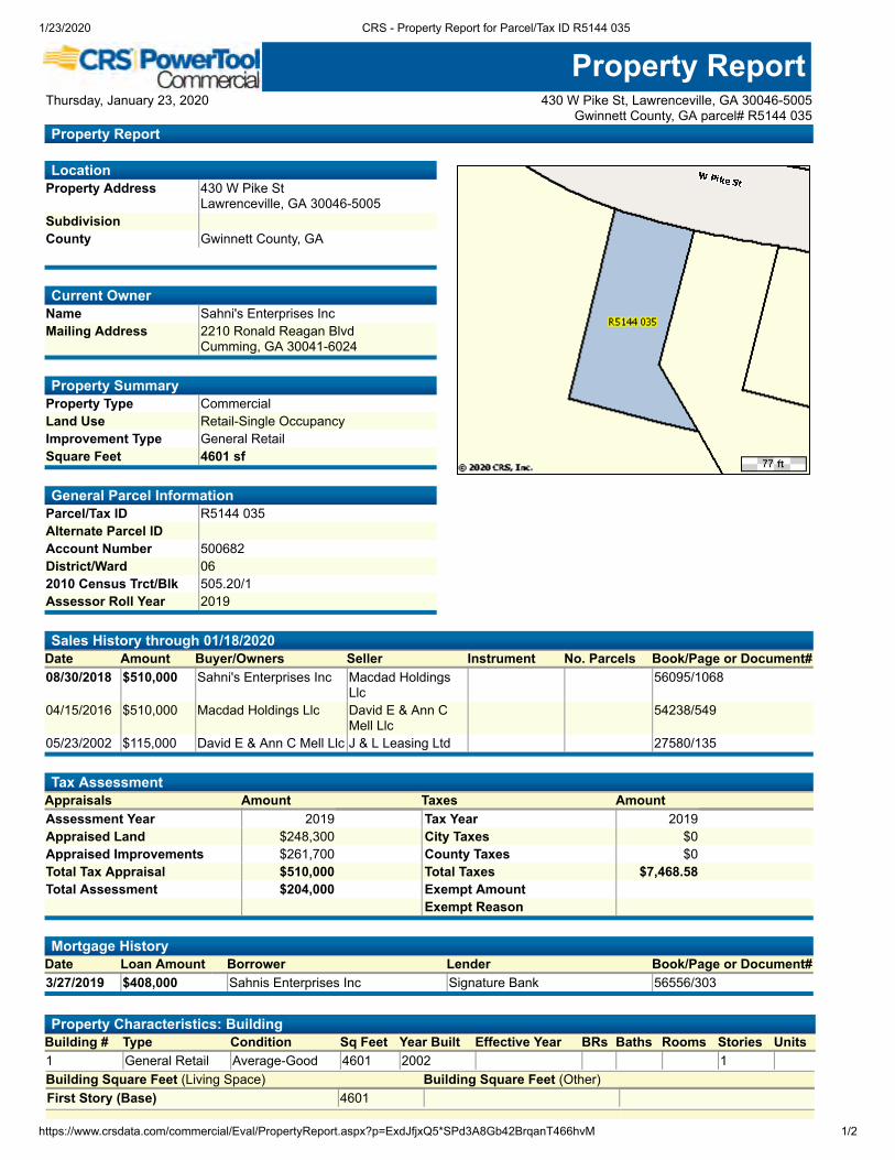
1/23/2020 CRS - Property Report for Parcel/Tax ID R5144 035
https://www.crsdata.com/commercial/Eval/PropertyReport.aspx?p=ExdJfjxQ5*SPd3A8Gb42BrqanT466hvM 1/2
LocationProperty Address 430 W Pike St
Lawrenceville, GA 30046-5005Subdivision County Gwinnett County, GA
Current OwnerName Sahni's Enterprises Inc Mailing Address 2210 Ronald Reagan Blvd
Cumming, GA 30041-6024
Property SummaryProperty Type CommercialLand Use Retail-Single OccupancyImprovement Type General RetailSquare Feet 4601 sf
General Parcel InformationParcel/Tax ID R5144 035Alternate Parcel ID Account Number 500682District/Ward 062010 Census Trct/Blk 505.20/1Assessor Roll Year 2019
Property ReportThursday, January 23, 2020 430 W Pike St, Lawrenceville, GA 30046-5005
Gwinnett County, GA parcel# R5144 035Property Report
Sales History through 01/18/2020 Date Amount Buyer/Owners Seller Instrument No. Parcels Book/Page or Document#08/30/2018 $510,000 Sahni's Enterprises Inc Macdad Holdings
Llc 56095/1068
04/15/2016 $510,000 Macdad Holdings Llc David E & Ann CMell Llc
54238/549
05/23/2002 $115,000 David E & Ann C Mell Llc J & L Leasing Ltd 27580/135
Tax AssessmentAppraisals Amount Taxes AmountAssessment Year 2019 Tax Year 2019 Appraised Land $248,300 City Taxes $0 Appraised Improvements $261,700 County Taxes $0 Total Tax Appraisal $510,000 Total Taxes $7,468.58 Total Assessment $204,000 Exempt Amount Exempt Reason
Mortgage HistoryDate Loan Amount Borrower Lender Book/Page or Document#3/27/2019 $408,000 Sahnis Enterprises Inc Signature Bank 56556/303
Property Characteristics: Building Building # Type Condition Sq Feet Year Built Effective Year BRs Baths Rooms Stories Units1 General Retail Average-Good 4601 2002 1 Building Square Feet (Living Space) Building Square Feet (Other)First Story (Base) 4601

1/23/2020 CRS - Property Report for Parcel/Tax ID R5144 035
https://www.crsdata.com/commercial/Eval/PropertyReport.aspx?p=ExdJfjxQ5*SPd3A8Gb42BrqanT466hvM 2/2
Construction Quality Average Roof Framing Shape Roof Cover Deck Partitions Cabinet Millwork Common Wall Floor Finish Foundation Interior Finish Floor System Air Conditioning Exterior Wall Heat Type Structural Framing Wood Frame Bathroom Tile Fireplace Plumbing Fixtures Other Occupancy Building Data Source
Property Characteristics: Extra FeaturesFeature Size or Description Year Built ConditionPaving Com Canopy - Go
Property Characteristics: LotLand Use Retail-Single Occupancy Lot Dimensions Block/Lot Lot Square Feet 24,829Latitude/Longitude 33.957965°/-84.002212° Acreage 0.57
Property Characteristics: Utilities/AreaGas Source Public Road Type PavedElectric Source Public Topography LevelWater Source Public District Trend Sewer Source Public Special School District 1 Zoning Code Bg-General Business Special School District 2 Owner Type
Legal DescriptionSubdivision Plat Book/Page Block/Lot Description Ga Hwy 120District/Ward 06
Fema Flood Zones
Zone Code Flood Risk BFE Description FIRM Panel IDFirm PanelEff. Date
X Minimal Area of minimal flood hazard, usually depicted on FIRMs as above the500-year flood level.
13135C0088F 09/29/2006
Thursday, January 23, 2020 430 W Pike St, Lawrenceville, GA 30046-5005Gwinnett County, GA parcel# R5144 035
©COPYRIGHT 2020 COURTHOUSE RETRIEVAL SYSTEM. ALL RIGHTS RESERVED.Information Deemed Reliable But Not Guaranteed.
Contact Us at (800) 374-7488 ext 3 for Help.
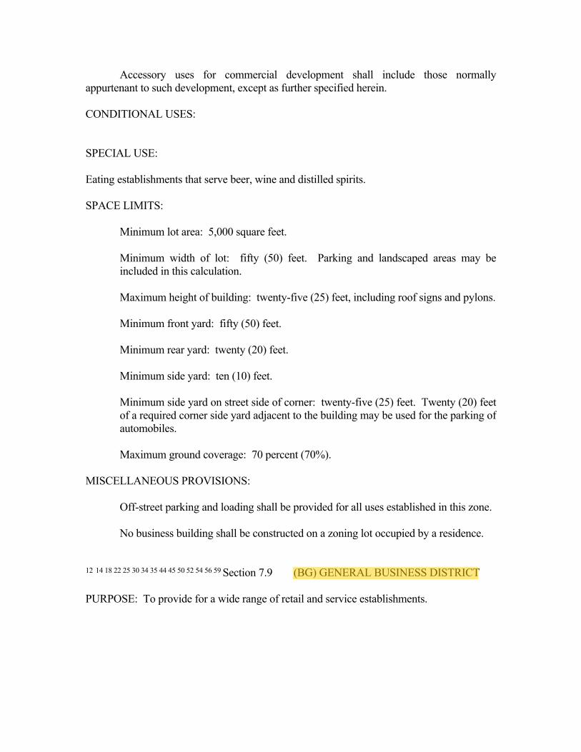
Accessory uses for commercial development shall include those normallyappurtenant to such development, except as further specified herein.
CONDITIONAL USES:
SPECIAL USE:
Eating establishments that serve beer, wine and distilled spirits.
SPACE LIMITS:
Minimum lot area: 5,000 square feet.
Minimum width of lot: fifty (50) feet. Parking and landscaped areas may beincluded in this calculation.
Maximum height of building: twenty-five (25) feet, including roof signs and pylons.
Minimum front yard: fifty (50) feet.
Minimum rear yard: twenty (20) feet.
Minimum side yard: ten (10) feet.
Minimum side yard on street side of corner: twenty-five (25) feet. Twenty (20) feetof a required corner side yard adjacent to the building may be used for the parking ofautomobiles.
Maximum ground coverage: 70 percent (70%).
MISCELLANEOUS PROVISIONS:
Off-street parking and loading shall be provided for all uses established in this zone.
No business building shall be constructed on a zoning lot occupied by a residence.
12 14 18 22 25 30 34 35 44 45 50 52 54 56 59 Section 7.9 (BG) GENERAL BUSINESS DISTRICT
PURPOSE: To provide for a wide range of retail and service establishments.

PRINCIPAL PERMITTED USES:
Retail and service stores of the following types, provided that all waste materials bekept within a sight-obscuring enclosure:
Animal hospitals or veterinary clinics*
Apparel stores
Automobile Brokers, office only, limit only two cars for sale on the property andthey may not be on the property overnight. No advertising on the vehicle.
Automobile parking lot
Barber & beauty shop
Boarding or breeding kennel*
Book & stationery stores
Camera & photographic supply stores
Coin-operated laundries
Commercial greenhouses or plant nursery
Commercial outdoor recreational enterprises
Convalescent home
Hobby and craft shops.
Day-care nurseries & kindergartens
Drug stores
Dry-cleaning pickup
Dry-cleaning plants
Electrical supply stores
Existing wholesale & retail sales of lumber & building, plumbing & electricalmaterials
Farm & garden supply stores

Florists
Furniture, homes, furnishings equipment stores
Gasoline service stations which do not conduct any automotive repairs, body andfender work, or automobile painting and at which all used and waste materials arekept withing a solid enclosure so that the contents are not visible from the street orhighway.
General merchandise stores
Grocery stores
Gymnastics Academy
Indoor theaters & other indoor places of amusements
Jewelry stores
Lumber, hardware & other material establishments
Martial Arts Studio
Medical & dental laboratories
Newspaper & printing plants
Nursing Home
Offices of health service practitioners - physicians, dentists, chiropractors, etc.
Off-street parking lots & garages
Outdoor Carnivals, provided that the parcel has a minimum of five (5) acres, allstructures, including overhang, must be set back a minimum of fifty (50) feet fromthe right of way and forty (40) feet from the common property lines, and theoperator must have the following items approved by the Department of Planning,Zoning & Inspections: site plan showing the boundary survey, streets, overheadutilities and the location of amusements, as well as the duration of the carnival.
Paint, glass & wallpaper stores
Pet shops & dog grooming shops
Plant nursery & sales facilities

Plumbing & heating equipment dealers
Publishing & printing establishments
Radio & television studios
Real estate sales office.
Restaurants
Retail automobile parts & tire stores
Specialized non-degree schools
Sporting goods stores
Television, radio and small appliance repair.
Tool & Machine shops (less than 10,000 square feet), provided theestablishment meets the following further imposed standards:
(1) No outside storage is permitted;
(2) All work shall be conducted inside of the establishment; and
(3) No operation shall be carried on which involves noise in excess of thecurrent standards promulgated by the Department of Housing and UrbanDevelopment. Noise levels shall be measured at the property line and noisein excess of prescribed levels shall be muffled so as not to be objectionabledue to intermittence, frequency or shrillness.
Wholesale warehouses with no outdoor storage
* No outside kennel
Any principal permitted use permitted in the BN District.
Any principal permitted use permitted in the OI District.
Other retail and service establishments which may be determined by the CityCouncil, upon recommendation of the Planning Commission, to be similar to theabove-listed principal permitted uses and which are in harmony with the purpose ofthis district, but not including those uses which are not mentioned in this district butare specifically enumerated in another district.

Public and quasi-public buildings.
Railroad through and spur tracks, but no sidings or other terminal type facilities andno service, repair or administrative facilities.
Utility substations necessary to the functioning of the utility, but not includinggeneral business offices, maintenance facilities and other general system facilities,when located according to the yard space rules set forth in this section for dwellingsand having a landscaped or masonry barrier on all sides. Such buildings shallconform with all space limits of this district and shall be of such exterior design as toharmonize with nearby properties.
EXCLUDED USES:
The following uses are hereby declared incompatible with the purpose of the BGDistrict and are hereby expressly excluded:
Mobile home subdivisions and mobile home parks.
Billboards and general advertising signs.
Drive-in theaters and drive-in food establishments.
Motel and motor hotels.
Taverns, bars and cocktail lounges.
Automobile wrecking operations, junk or salvage yards.
Dry-cleaning, laundry and dying plants employing over twenty (20) personsexclusive of drivers.
Any use not enumerated as permitted in this district, but which is specificallyprovided for in another district.
PERMITTED ACCESSORY USES:
Accessory uses for commercial development shall include those normallyappurtenant to such development except as further specified herein.
Electronic Message Center signs meeting the requirements set forth in Article X,Section 10.5(C)(10)(x), provided that such signs are used and operated by a gasolineservice station.

1 An applicant for a special use permit under this section shall be a “Dealer” as defined inO. C. G.A. § 10-1-622 and the location shall be a “Dealership Facilities” as defined in thesame section of the Georgia Code.
Outdoor storage of vending machines, boxes or other similar containers used todistribute food or beverage, newspapers, propane tanks, ice, videos or othersimilar consumer product, provided that the following requirements are met:
(1) The vending machine is not greater than seven (7) feet in height or morethan four (4) feet in width or depth and the number of vending machines,boxes or other similar containers shall not exceed one machine for eachthree thousand (3,000) square feet of building area and a maximum ofthree (3) machines, boxes or other similar containers per lot; and
(2) The machines shall be located against and parallel to the building façade.
CONDITIONAL USES:
None.
SPECIAL USE:
1New and Used Automobile and Pickup Sales Dealers, provided thefollowing further imposed standards apply to new development:
(1) Fifteen (15) foot landscaped buffer fronting street, except forexisting uses.
Automobile Repair Shops, provided the establishment meets the following furtherimposed standards:
(1) Automobile service bays are not permitted to face the street;
(2) Fifteen (15) foot landscaped buffer fronting street;
(3) Overnight parking is permitted in side and rear yard but the parkingmust be screened from view with minimum six (6) foot opaquefencing;
No work shall be conducted on the outside grounds of the establishment;
No metal building facades; and
Automobile Wash Service (Automatic Car Washes with Interior Detail Service),provided the establishment meets the following further imposed standards:

No metal building facades; and,
Pre-fabricated awning type structures are permitted.
Automobile Wash Service (Self-Service), provided the establishment meets thefollowing further imposed standards:
No metal building facades; and,
Pre-fabricated awning type structures are not permitted.
Billiard Rooms
Communication Towers
Crematories
Drug Abuse Treatment Facility, provided the following criteria are met:
(1) The Drug Abuse Treatment Facility must at all times be approved and properly licensed through the Georgia Department of Community Health;
(2) No Drug Abuse Treatment Facility may be located within one thousand (1,000) feet of any residential property, measured from property line to property line;
(3) No Drug Abuse Treatment Facility may be located within one thousand (1,000) feet of any other Drug Abuse Treatment Facility, measured from property line to property line; and
(4) The Drug Abuse Treatment Facility must be located on a main thoroughfare.
Free-Standing Automated Teller Machine (ATM), provided the following standards aremet:
(1) Only one free-standing ATM may be installed per parcel;
(2) The structure built to house the ATM shall be architecturally compatible with theprimary structure and incorporate similar construction materials;
(3) The structure shall not exceed a height of twelve (12) feet;
(4) The structure shall be setback from any right-of-way at least as required by theBG zoning district;
(5) The structure may not be installed in any required parking spaces;
(6) A permanently installed trash receptacle shall be located within five (5) feet of thestructure which shall be maintained by the property owner;
(7) Installation shall not reduce any required or existing landscaping; and
(8) All requirements of O.C.G.A. § 7-8-1 et seq. shall be met;
(9) A marked and designated travel lane shall be provided with a landscape islandbuffer.
Funeral homes
Helicopter Landing Pads
Indoor Climate Controlled Storage Facility, provided the establishment meets the following further imposed standards:
(5) Storage units shall not be used for manufacturing, retail or wholesale, office or other businesses or service use.
(6) Storage units shall not be used for human habitation.
(7) Access to all storage units shall be from the interior of the main building. No access to a storage unit shall lead directly to the exterior of the building.
(8) Outdoor speakers or sound amplification systems shall be prohibited.
(9) No outdoor storage of any types shall be allowed at the facility.
(10) The facility shall provide adequate loading and unloading areas which shall be outside of all designated and required parking spaces, all travel lanes and all fire lanes.
Mobile Home Sales Lots, provided the establishment meets the following further imposed standards:
No mobile home sales lots are permitted within one hundred (100) feet of any residential property;
No lots smaller than twenty-five thousand (25,000) square feet;
All lots must have a permanent building made of brick, stone or wood frame of no less then one thousand (1000) square feet;
No metal building facades;

Fifteen (15) foot landscaped buffer fronting street; and,
Outdoor display of merchandise, goods or products offered for sale. In consideringwhether to grant or deny an application for a Special Use Permit for outdoor display, theCity Council shall consider the following:
(1) Whether the merchandise, goods or products offered for sale are of a typenormally sold by the permitted business;
(2) Whether the merchandise, goods or products offered for sale are of a typenormally displayed and sold outside;
(3) The location and manner of outdoor display on the property;
(4) The impact the display may have on the visibility of any roadway or driveway aswell as the impact on the flow of pedestrian traffic on sidewalks or walkways; and
(5) Whether the outdoor display will create visual clutter and be aestheticallyunpleasing.
Outdoor storage of items, equipment, materials and supplies which are not offered forsale but which are normally appurtenant to a permitted use. In considering whether togrant or deny an application for a Special Use Permit for outdoor storage, the City Councilshall consider the following:
(1) The type of items and materials to be stored; provided, however, that under nocircumstances shall an owner or occupant of any property store or be permitted tostore any junk, scrap metal, rags, paper, or abandoned, wrecked, junked or scrapmaterial, or any parts thereof, outdoors;
(2) The location and area of proposed outdoor storage on the property;
(3) The characteristics of surrounding properties; and
(4) Fencing or other screening to be used to reduce or eliminate visibility of the outdoorstorage.
Outdoor theaters
Parking of Commercial Vehicles (Tractor and/or Trailer)
Small Financial Institutions, provided the establishment meets the following further imposedstandards:
The use shall be permitted only on a parcel of land which has direct access to amajor thoroughfare;

The establishment shall not be permitted within one thousand (1,000) feet of anexisting small financial institution;
The establishment may not be within one hundred (100) feet of any residentialproperty; and,
Transportation Rental – Passenger Vehicle
Transportation Rental – Commercial Vehicle
Used Car Sales Lots, provided the establishment meets the following further imposedstandards:
No used car lots are permitted within one hundred (100) feet of any residentialproperty;
No lots smaller than twenty-five thousand (25,000) square feet;
All lots must have a permanent building made of brick, stone or wood frame of noless then one thousand (1000) square feet;
No metal building facades;
Fifteen (15) foot landscaped buffer fronting street.
SPACE LIMITS:
Minimum lot area: For business none. Residential structures shall conform with theprovisions of the RM District, except as may be modified by the Board of Appealsin accordance with the conditional use provisions of that district.
Minimum lot width: None for business.
Maximum height of building: thirty-five (35) feet.
Minimum front yard: fifty (50) feet.
Minimum rear yard: ten (10) feet, but forty (40) feet when abutting a residentialdistrict.
Minimum side yard: ten (10) feet.
Minimum side yard on street side of corner: twenty-five (25) feet.

Maximum ground coverage including accessory buildings, loading docks,incinerators and devices: ninety-five percent (95%).
MISCELLANEOUS PROVISIONS:
Off-street parking and loading shall be provided for all uses established in thisdistrict.
Only one (1) building used for a dwelling shall be permitted on one (1) lot except asotherwise provided herein.
Contractor’s offices’ conditions are:
(1) Maximum building size 10,000 sq. ft.
(2) Storage space in each unit not to exceed seventy percent (70%).
(3) Brick facades required for the following:
(a) front façade;
(b) façade that faces a street; and,
(c) façade that faces a residentially zoned property.
18 45 50Section 7.10 (BGC) CENTRAL GENERAL BUSINESS DISTRICT
PURPOSE: This district is designed to provide a general business district which will takeinto account the special characteristics of the Central Business District of the City.
PRINCIPAL PERMITTED USES:
Any principal permitted use permitted in the BG district.
Any principal permitted use permitted in the OI District.
Apartment houses, apartment hotels and mixed business and apartment buildingsconstructed to standards of the RM District.
PERMITTED ACCESSORY USES:
Any permitted accessory use allowed in the BG District.
CONDITIONAL USES:
Gasoline service stations.

Site Map430 W Pike St, Lawrenceville, Georgia, 30046 Prepared by EsriRings: 1, 3, 5 mile radii Latitude: 33.95842
Longitude: -84.00209
January 23, 2020
©2020 Esri Page 1 of 1

Demographic and Income Profile430 W Pike St, Lawrenceville, Georgia, 30046 Prepared by EsriRing: 1 mile radius Latitude: 33.95842
Longitude: -84.00209
Summary Census 2010 2019 2024Population 4,881 5,116 5,314Households 1,982 2,079 2,161Families 1,198 1,228 1,267Average Household Size 2.43 2.43 2.43Owner Occupied Housing Units 545 537 581Renter Occupied Housing Units 1,437 1,541 1,580Median Age 31.9 32.6 33.0
Trends: 2019 - 2024 Annual Rate Area State NationalPopulation 0.76% 1.10% 0.77%Households 0.78% 1.09% 0.75%Families 0.63% 1.01% 0.68%Owner HHs 1.59% 1.41% 0.92%Median Household Income 3.58% 2.70% 2.70%
2019 2024 Households by Income Number Percent Number Percent
<$15,000 315 15.2% 245 11.3%$15,000 - $24,999 268 12.9% 237 11.0%$25,000 - $34,999 283 13.6% 260 12.0%$35,000 - $49,999 338 16.3% 348 16.1%$50,000 - $74,999 460 22.1% 525 24.3%$75,000 - $99,999 189 9.1% 240 11.1%$100,000 - $149,999 118 5.7% 165 7.6%$150,000 - $199,999 65 3.1% 87 4.0%$200,000+ 44 2.1% 53 2.5%
Median Household Income $41,448 $49,414Average Household Income $56,054 $65,346Per Capita Income $22,921 $26,654
Census 2010 2019 2024 Population by Age Number Percent Number Percent Number Percent
0 - 4 438 9.0% 430 8.4% 451 8.5%5 - 9 389 8.0% 386 7.5% 392 7.4%10 - 14 322 6.6% 323 6.3% 327 6.2%15 - 19 349 7.2% 312 6.1% 329 6.2%20 - 24 361 7.4% 387 7.6% 395 7.4%25 - 34 824 16.9% 922 18.0% 949 17.9%35 - 44 647 13.3% 649 12.7% 679 12.8%45 - 54 588 12.0% 559 10.9% 558 10.5%55 - 64 443 9.1% 473 9.2% 460 8.7%65 - 74 241 4.9% 359 7.0% 401 7.5%75 - 84 195 4.0% 209 4.1% 264 5.0%
85+ 84 1.7% 107 2.1% 110 2.1%Census 2010 2019 2024
Race and Ethnicity Number Percent Number Percent Number PercentWhite Alone 2,338 47.9% 2,000 39.1% 1,827 34.4%Black Alone 1,671 34.2% 2,102 41.1% 2,409 45.3%American Indian Alone 28 0.6% 26 0.5% 24 0.5%Asian Alone 146 3.0% 196 3.8% 228 4.3%Pacific Islander Alone 2 0.0% 2 0.0% 2 0.0%Some Other Race Alone 538 11.0% 592 11.6% 601 11.3%Two or More Races 158 3.2% 199 3.9% 223 4.2%
Hispanic Origin (Any Race) 1,064 21.8% 1,199 23.4% 1,269 23.9%Data Note: Income is expressed in current dollars.
Source: U.S. Census Bureau, Census 2010 Summary File 1. Esri forecasts for 2019 and 2024.
January 23, 2020
©2020 Esri Page 1 of 6

Demographic and Income Profile430 W Pike St, Lawrenceville, Georgia, 30046 Prepared by EsriRing: 1 mile radius Latitude: 33.95842
Longitude: -84.00209
AreaStateUSA
Trends 2019-2024Trends 2019-2024
Ann
ual R
ate
(in
perc
ent)
3.5
3
2.5
2
1.5
1
0.5
0Population Households Families Owner HHs Median HH Income
20192024
Population by AgePopulation by Age
Perc
ent
18
16
14
12
10
8
6
4
2
00-4 5-9 10-14 15-19 20-24 25-34 35-44 45-54 55-64 65-74 75-84 85+
2019 Household Income 2019 Household Income
<$15K15.1%
$15K - $24K12.9%$25K - $34K
13.6%
$35K - $49K16.3%
$50K - $74K22.1%
$75K - $99K9.1%
$100K - $149K5.7%
$150K - $199K3.1%
$200K+2.1%
2019 Population by Race2019 Population by Race
Perc
ent
40
35
30
25
20
15
10
5
0White Black Am. Ind. Asian Pacific Other Two+
2019 Percent Hispanic Origin: 23.4%
Source: U.S. Census Bureau, Census 2010 Summary File 1. Esri forecasts for 2019 and 2024.
January 23, 2020
©2020 Esri Page 2 of 6

Demographic and Income Profile430 W Pike St, Lawrenceville, Georgia, 30046 Prepared by EsriRing: 3 mile radius Latitude: 33.95842
Longitude: -84.00209
Summary Census 2010 2019 2024Population 70,808 77,150 82,203Households 23,124 25,337 26,964Families 16,695 18,055 19,128Average Household Size 2.96 2.96 2.97Owner Occupied Housing Units 14,160 15,412 16,697Renter Occupied Housing Units 8,964 9,926 10,267Median Age 32.2 33.4 33.5
Trends: 2019 - 2024 Annual Rate Area State NationalPopulation 1.28% 1.10% 0.77%Households 1.25% 1.09% 0.75%Families 1.16% 1.01% 0.68%Owner HHs 1.61% 1.41% 0.92%Median Household Income 2.71% 2.70% 2.70%
2019 2024 Households by Income Number Percent Number Percent
<$15,000 1,980 7.8% 1,539 5.7%$15,000 - $24,999 1,828 7.2% 1,589 5.9%$25,000 - $34,999 2,635 10.4% 2,367 8.8%$35,000 - $49,999 3,442 13.6% 3,359 12.5%$50,000 - $74,999 5,488 21.7% 5,693 21.1%$75,000 - $99,999 4,088 16.1% 4,681 17.4%$100,000 - $149,999 3,730 14.7% 4,826 17.9%$150,000 - $199,999 1,219 4.8% 1,759 6.5%$200,000+ 927 3.7% 1,151 4.3%
Median Household Income $60,074 $68,654Average Household Income $76,144 $87,177Per Capita Income $25,428 $29,094
Census 2010 2019 2024 Population by Age Number Percent Number Percent Number Percent
0 - 4 5,513 7.8% 5,488 7.1% 5,943 7.2%5 - 9 5,747 8.1% 5,451 7.1% 5,748 7.0%10 - 14 5,615 7.9% 5,384 7.0% 5,714 7.0%15 - 19 5,342 7.5% 5,331 6.9% 5,500 6.7%20 - 24 5,013 7.1% 5,937 7.7% 6,083 7.4%25 - 34 11,310 16.0% 12,840 16.6% 14,227 17.3%35 - 44 11,435 16.1% 10,786 14.0% 11,656 14.2%45 - 54 9,853 13.9% 10,218 13.2% 9,905 12.0%55 - 64 6,188 8.7% 8,270 10.7% 8,403 10.2%65 - 74 2,633 3.7% 4,807 6.2% 5,713 6.9%75 - 84 1,560 2.2% 1,889 2.4% 2,514 3.1%
85+ 597 0.8% 749 1.0% 799 1.0%Census 2010 2019 2024
Race and Ethnicity Number Percent Number Percent Number PercentWhite Alone 34,271 48.4% 30,160 39.1% 28,144 34.2%Black Alone 21,451 30.3% 28,206 36.6% 33,189 40.4%American Indian Alone 364 0.5% 346 0.4% 332 0.4%Asian Alone 5,915 8.4% 7,706 10.0% 8,871 10.8%Pacific Islander Alone 34 0.0% 34 0.0% 34 0.0%Some Other Race Alone 6,326 8.9% 7,480 9.7% 7,908 9.6%Two or More Races 2,447 3.5% 3,217 4.2% 3,724 4.5%
Hispanic Origin (Any Race) 15,282 21.6% 18,053 23.4% 19,703 24.0%Data Note: Income is expressed in current dollars.
Source: U.S. Census Bureau, Census 2010 Summary File 1. Esri forecasts for 2019 and 2024.
January 23, 2020
©2020 Esri Page 3 of 6

Demographic and Income Profile430 W Pike St, Lawrenceville, Georgia, 30046 Prepared by EsriRing: 3 mile radius Latitude: 33.95842
Longitude: -84.00209
AreaStateUSA
Trends 2019-2024Trends 2019-2024
Ann
ual R
ate
(in
perc
ent)
2.5
2
1.5
1
0.5
0Population Households Families Owner HHs Median HH Income
20192024
Population by AgePopulation by Age
Perc
ent
16
14
12
10
8
6
4
2
00-4 5-9 10-14 15-19 20-24 25-34 35-44 45-54 55-64 65-74 75-84 85+
2019 Household Income 2019 Household Income
<$15K7.8%
$15K - $24K7.2%
$25K - $34K10.4%$35K - $49K
13.6%
$50K - $74K21.7%
$75K - $99K16.1%
$100K - $149K14.7%
$150K - $199K4.8%
$200K+3.7%
2019 Population by Race2019 Population by Race
Perc
ent
35
30
25
20
15
10
5
0White Black Am. Ind. Asian Pacific Other Two+
2019 Percent Hispanic Origin: 23.4%
Source: U.S. Census Bureau, Census 2010 Summary File 1. Esri forecasts for 2019 and 2024.
January 23, 2020
©2020 Esri Page 4 of 6

Demographic and Income Profile430 W Pike St, Lawrenceville, Georgia, 30046 Prepared by EsriRing: 5 mile radius Latitude: 33.95842
Longitude: -84.00209
Summary Census 2010 2019 2024Population 186,503 210,939 227,472Households 60,231 68,205 73,486Families 46,784 52,399 56,235Average Household Size 3.04 3.05 3.05Owner Occupied Housing Units 44,622 50,167 54,913Renter Occupied Housing Units 15,609 18,038 18,573Median Age 33.6 34.9 35.2
Trends: 2019 - 2024 Annual Rate Area State NationalPopulation 1.52% 1.10% 0.77%Households 1.50% 1.09% 0.75%Families 1.42% 1.01% 0.68%Owner HHs 1.82% 1.41% 0.92%Median Household Income 2.15% 2.70% 2.70%
2019 2024 Households by Income Number Percent Number Percent
<$15,000 4,057 5.9% 3,244 4.4%$15,000 - $24,999 3,650 5.4% 3,250 4.4%$25,000 - $34,999 5,490 8.0% 5,011 6.8%$35,000 - $49,999 8,247 12.1% 7,965 10.8%$50,000 - $74,999 13,824 20.3% 14,081 19.2%$75,000 - $99,999 10,922 16.0% 12,173 16.6%$100,000 - $149,999 12,470 18.3% 15,474 21.1%$150,000 - $199,999 4,984 7.3% 6,751 9.2%$200,000+ 4,561 6.7% 5,539 7.5%
Median Household Income $72,042 $80,112Average Household Income $91,906 $103,395Per Capita Income $29,754 $33,429
Census 2010 2019 2024 Population by Age Number Percent Number Percent Number Percent
0 - 4 13,485 7.2% 13,969 6.6% 15,349 6.7%5 - 9 15,249 8.2% 14,658 6.9% 15,521 6.8%10 - 14 15,797 8.5% 15,249 7.2% 16,049 7.1%15 - 19 15,027 8.1% 14,633 6.9% 14,997 6.6%20 - 24 11,607 6.2% 14,125 6.7% 13,753 6.0%25 - 34 25,924 13.9% 33,220 15.7% 37,164 16.3%35 - 44 30,500 16.4% 29,307 13.9% 33,917 14.9%45 - 54 29,450 15.8% 29,596 14.0% 28,172 12.4%55 - 64 17,619 9.4% 25,696 12.2% 26,087 11.5%65 - 74 7,160 3.8% 13,934 6.6% 17,564 7.7%75 - 84 3,551 1.9% 4,956 2.3% 7,067 3.1%
85+ 1,136 0.6% 1,598 0.8% 1,831 0.8%Census 2010 2019 2024
Race and Ethnicity Number Percent Number Percent Number PercentWhite Alone 96,846 51.9% 89,203 42.3% 84,360 37.1%Black Alone 49,196 26.4% 68,191 32.3% 81,947 36.0%American Indian Alone 848 0.5% 829 0.4% 805 0.4%Asian Alone 19,373 10.4% 27,096 12.8% 32,079 14.1%Pacific Islander Alone 70 0.0% 72 0.0% 72 0.0%Some Other Race Alone 14,122 7.6% 17,142 8.1% 18,254 8.0%Two or More Races 6,049 3.2% 8,406 4.0% 9,954 4.4%
Hispanic Origin (Any Race) 35,512 19.0% 43,258 20.5% 47,784 21.0%Data Note: Income is expressed in current dollars.
Source: U.S. Census Bureau, Census 2010 Summary File 1. Esri forecasts for 2019 and 2024.
January 23, 2020
©2020 Esri Page 5 of 6

Demographic and Income Profile430 W Pike St, Lawrenceville, Georgia, 30046 Prepared by EsriRing: 5 mile radius Latitude: 33.95842
Longitude: -84.00209
AreaStateUSA
Trends 2019-2024Trends 2019-2024
Ann
ual R
ate
(in
perc
ent)
2.5
2
1.5
1
0.5
0Population Households Families Owner HHs Median HH Income
20192024
Population by AgePopulation by Age
Perc
ent
16
14
12
10
8
6
4
2
00-4 5-9 10-14 15-19 20-24 25-34 35-44 45-54 55-64 65-74 75-84 85+
2019 Household Income 2019 Household Income
<$15K5.9%
$15K - $24K5.4%
$25K - $34K8.0%
$35K - $49K12.1%
$50K - $74K20.3%
$75K - $99K16.0%
$100K - $149K18.3%
$150K - $199K7.3%
$200K+6.7%
2019 Population by Race2019 Population by Race
Perc
ent
40
35
30
25
20
15
10
5
0White Black Am. Ind. Asian Pacific Other Two+
2019 Percent Hispanic Origin: 20.5%
Source: U.S. Census Bureau, Census 2010 Summary File 1. Esri forecasts for 2019 and 2024.
January 23, 2020
©2020 Esri Page 6 of 6