for personal use only - asx · 2020. 2. 10. · field mapping accompanied by sampling commences...
TRANSCRIPT

ASX Code
KTA, KTAOC
Capital Structure
218,750,000 Fully Paid Shares 85,000,000 Options @ 5c exp 31/07/21 5,000,000 Options @ 7.5c exp 31/07/21 12,000,000 Options @ 10c exp 24/10/20
11 February 2020
Porphyry pattern delineated at Sugarloaf
Reinterpretation of regional aeromagnetic data identifies sizeable geophysical pattern with
characteristics of porphyry-style mineralisation at the Sugarloaf Target Area
The pattern of a high magnetic response surrounded by a magnetic low geophysical
response is well established for this style of deposit
The pattern lies over an interpreted splay off the Neurea Fault, which along strike may
influence copper and gold mineralisation at the nearby Copper Hill Deposit
The Sugarloaf Creek Copper Anomaly and a chip sample reporting 0.53g/t gold and
1,250ppm Cu, lie adjacent to the pattern
Field mapping accompanied by sampling commences this week
Krakatoa Resources Limited (ASX: KTA) (“Krakatoa” or the “Company”) is pleased to announce that it has
commenced exploration on the Sugarloaf Target Area at its 100% owned Belgravia Project, located near
Orange, NSW. The Sugarloaf Target Area lies within the same Ordovician volcanic belt which hosts the
Copper Hill deposit to the immediate northwest, Browns Creek, Cadia and the recent Boda discovery by
Alkane Resources.
The Company seeks large volcanogenic porphyry-style gold and copper systems in magnetically complex
zones in the Lachlan Fold Belt. The exploration effort at Sugarloaf will focus on identifying Copper Hill style
porphyry-hosted mineralisation utilising airborne geophysics, field mapping and some surface
geochemistry in exposed areas followed by drill testing of the resulting targets.
Sugarloaf is also considered prospective for mesothermal vein gold deposits on splays to several
significant faults and epithermal gold-silver and contact-metasomatic (skarn and other carbonate-
replacement styles) gold-base metals deposits.
For
per
sona
l use
onl
y

Project Geology
The Neurea Fault and associated splays, which thrusts Ordovician sequences over Silurian rocks traverse
the prospect. Several NNW-trending gabbroic dykes also intrude the Ordovician Oakdale Formation
sedimentary rocks near the Neurea Fault. Devonian-aged quartz diorite intrudes Silurian sedimentary
rocks immediately south of the prospect, and there are extensive areas of Tertiary Basalt.
Prospectivity
Reconsideration of the regional aeromagnetic data has identified a sizeable geophysical feature
considered characteristic of porphyry-style copper-gold mineralisation, including magnetite alteration
within the core and around the margins of the system, which are separated by magnetic low associated
with late-stage phyllic, magnetite destructive alteration. In plan-view, a target system will be represented
as a high magnetic response surrounded by a magnetic low (white/red outline: Figure 1).
Figure 1: Sizeable porphyry pattern identified in regional aeromagnetic data
For
per
sona
l use
onl
y

The interpreted feature lies coincident with a northwest-trending splay off the Neurea Fault and carries a
single anomalous chip sample reporting 0.53g/t gold and 1250ppm copper. Extensions to the structure
may influence copper and gold mineralisation at the Copper Hill Deposit to the northwest. It also lies
immediately southeast of the Sugarloaf Creek Cu anomaly - a large, low order drainage anomaly originally
discovered by Homestake Mining in 1991, which lies over part of the Molong Creek system. The weakly
anomalous stream copper geochemistry, with a peak value of 130ppm Copper (averaging 96ppm Copper
from the adjacent five samples), extends in a direction parallel to the splay.
Table 1- Rock chip results (Cypress Minerals, 1989) Sample_id MGA_zone GDA_E GDA_N AHD Au Cu Pb Zn
308664 55 676850 6336420 567 0.05 58 106 5
308665 55 676890 6336170 572 -0.01 186 24 83
308666 55 677000 6336050 580 0.02 140 6 92
308667 55 677375 6335940 602 0.01 74 7 10
308668 55 677250 6335940 595 -0.01 49 8 4
308669 55 677150 6335940 587 -0.01 480 10 88
308670 55 677105 6335780 585 -0.01 71 5 46
308671 55 677800 6335125 580 -0.01 159 6 83
308672 55 678050 6335000 575 0.05 890 288 670
308673 55 678050 6335005 572 0.09 346 282 440
308674 55 678045 6335000 572 0.53 1250 1060 660
Additionally, a small lead-zinc deposit known as Molong lead-zinc deposit or ‘Blunt’s’ is located 1 km south
of EL 8153, where altered Silurian limestone is faulted against Ordovician tuffaceous and conglomeratic
sedimentary rocks of the Fairbridge Volcanics. The faulted contact extends north into the licence area and
is prospective for structurally-controlled gold, arsenic and copper mineralisation.
The Company is currently securing land access and anticipates commencing field activities later this week.
The field program will include geological mapping and surface geochemistry in the exposed areas near
Sugarloaf and Blunt’s, followed by drill testing of the resulting targets.
Executive Chairman Colin Locke commented:
“The Sugarloaf Target Area provides us with an additional opportunity to uncover a large volcanogenic
porphyry-style gold and copper system. We look forward to attacking Sugarloaf with a systematic, modern
day exploration program whilst eagerly awaiting approval to commence our maiden drill program at the
Bell Valley Target Area.”
Authorised for release by the Board. FOR FURTHER INFORMATION: Colin Locke Executive Chairman +61 457 289 582 [email protected]
For
per
sona
l use
onl
y
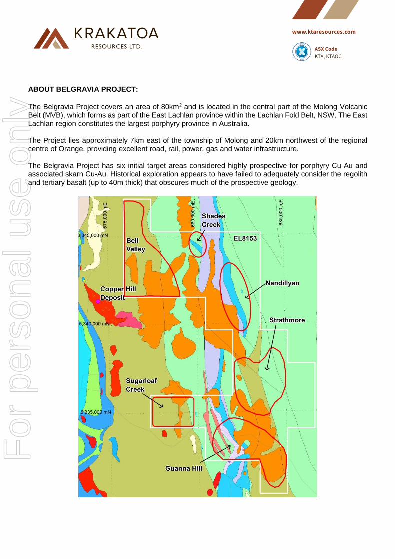
ABOUT BELGRAVIA PROJECT:
The Belgravia Project covers an area of 80km2 and is located in the central part of the Molong Volcanic Belt (MVB), which forms as part of the East Lachlan province within the Lachlan Fold Belt, NSW. The East Lachlan region constitutes the largest porphyry province in Australia. The Project lies approximately 7km east of the township of Molong and 20km northwest of the regional centre of Orange, providing excellent road, rail, power, gas and water infrastructure. The Belgravia Project has six initial target areas considered highly prospective for porphyry Cu-Au and associated skarn Cu-Au. Historical exploration appears to have failed to adequately consider the regolith and tertiary basalt (up to 40m thick) that obscures much of the prospective geology.
For
per
sona
l use
onl
y

Disclaimer Forward-looking statements are statements that are not historical facts. Words such as “expect(s)”,
“feel(s)”, “believe(s)”, “will”, “may”, “anticipate(s)” and similar expressions are intended to identify forward-
looking statements. These statements include, but are not limited to statements regarding future
production, resources or reserves and exploration results. All of such statements are subject to certain
risks and uncertainties, many of which are difficult to predict and generally beyond the control of the
Company, that could cause actual results to differ materially from those expressed in, or implied or
projected by, the forward-looking information and statements. These risks and uncertainties include, but
are not limited to: (i) those relating to the interpretation of drill results, the geology, grade and continuity of
mineral deposits and conclusions of economic evaluations, (ii) risks relating to possible variations in
reserves, grade, planned mining dilution and ore loss, or recovery rates and changes in project parameters
as plans continue to be refined, (iii) the potential for delays in exploration or development activities or the
completion of feasibility studies, (iv) risks related to commodity price and foreign exchange rate
fluctuations, (v) risks related to failure to obtain adequate financing on a timely basis and on acceptable
terms or delays in obtaining governmental approvals or in the completion of development or construction
activities, and (vi) other risks and uncertainties related to the Company’s prospects, properties and
business strategy. Our audience is cautioned not to place undue reliance on these forward-looking
statements that speak only as of the date hereof, and we do not undertake any obligation to revise and
disseminate forward-looking statements to reflect events or circumstances after the date hereof, or to
reflect the occurrence of or non-occurrence of any events.
Competent Persons Statement The information in this announcement is based on and fairly represents information compiled by Mr
Jonathan King, consultant geologist, who is a Member of the Australian Institute of Geoscientists and
employed by Collective Prosperity Pty Ltd, and is an accurate representation of the available data and
studies for the Project. Mr King has sufficient experience relevant to the style of mineralisation and type
of deposit under consideration, and to the activity which he has undertaken, to qualify as a Competent
Person as defined in the 2012 Edition of the Joint Ore Reserves Committee (JORC) Australasian Code
for Reporting of Exploration Results, Mineral Resources and Ore Reserves. Mr King consents to the
inclusion in this announcement of the matters based on this information in the form and context in which
it appears.
For
per
sona
l use
onl
y

JORC Code, 2012 Edition – Table 1 report template
Section 1 Sampling Techniques and Data
(Criteria in this section apply to all succeeding sections.)
Criteria JORC Code explanation Commentary
Sampling techniques
Nature and quality of sampling (eg cut channels, random chips, or specific specialised industry standard measurement tools appropriate to the minerals under investigation, such as down hole gamma sondes, or handheld XRF instruments, etc). These examples should not be taken as limiting the broad meaning of sampling.
Include reference to measures taken to ensure sample representivity and the appropriate calibration of any measurement tools or systems used.
Aspects of the determination of mineralisation that are Material to the Public Report.
In cases where ‘industry standard’ work has been done this would be relatively simple (eg ‘reverse circulation drilling was used to obtain 1 m samples from which 3 kg was pulverised to produce a 30 g charge for fire assay’). In other cases more explanation may be required, such as where there is coarse gold that has inherent sampling problems. Unusual commodities or mineralisation types (eg submarine nodules) may warrant disclosure of detailed information.
Homestake Mining and Cypress Minerals investigated the Sugarloaf Creek with BCL streams and Rock chips in the late 1980s/early1990s.
The were conventional reconnaissance exploration samples. Stream sediment samples targeted second or third-order drainages. Rock chips were taken in areas were anomalous streams were encountered. The sampling method is not outlined.
Limited work has been undertaken since this time.
Drilling techniques
Drill type (eg core, reverse circulation, open-hole hammer, rotary air blast, auger, Bangka, sonic, etc) and details (eg core diameter, triple or standard tube, depth of diamond tails, face-sampling bit or other type, whether core is oriented and if so, by what method, etc).
No drilling undertaken
Drill sample recovery
Method of recording and assessing core and chip sample recoveries and results assessed.
Measures taken to maximise sample recovery and ensure representative nature of the samples.
Whether a relationship exists between sample recovery and grade and whether sample bias may have occurred due to preferential loss/gain of fine/coarse material.
No drilling undertaken
Logging Whether core and chip samples have been geologically and geotechnically logged to a level of detail to support appropriate Mineral Resource estimation,
No drilling undertaken
For
per
sona
l use
onl
y

Criteria JORC Code explanation Commentary
mining studies and metallurgical studies.
Whether logging is qualitative or quantitative in nature. Core (or costean, channel, etc) photography.
The total length and percentage of the relevant intersections logged.
Sub-sampling techniques and sample preparation
If core, whether cut or sawn and whether quarter, half or all core taken.
If non-core, whether riffled, tube sampled, rotary split, etc and whether sampled wet or dry.
For all sample types, the nature, quality and appropriateness of the sample preparation technique.
Quality control procedures adopted for all sub-sampling stages to maximise representivity of samples.
Measures taken to ensure that the sampling is representative of the in situ material collected, including for instance results for field duplicate/second-half sampling.
Whether sample sizes are appropriate to the grain size of the material being sampled.
No drilling undertaken
No subsampling performed
No QA/QC approaches reported
Quality of assay data and laboratory tests
The nature, quality and appropriateness of the assaying and laboratory procedures used and whether the technique is considered partial or total.
For geophysical tools, spectrometers, handheld XRF instruments, etc, the parameters used in determining the analysis including instrument make and model, reading times, calibrations factors applied and their derivation, etc.
Nature of quality control procedures adopted (eg standards, blanks, duplicates, external laboratory checks) and whether acceptable levels of accuracy (ie lack of bias) and precision have been established.
Chip samples were submitted to and assayed by ALS Minerals (Orange): gold by Fire Assay (method PM217), copper, lead, zinc, silver, arsenic were analysed by AAS(G001)
Bulk cyanide leach samples were collected as 5kg/-2mm and submitted to and assayed by ALS Minerals in Orange for gold. Copper, lead, zinc were read by AAS.
Verification of sampling and assaying
The verification of significant intersections by either independent or alternative company personnel.
The use of twinned holes.
Documentation of primary data, data entry procedures, data verification, data storage (physical and electronic) protocols.
Discuss any adjustment to assay data.
No drilling
No adjustments were made to any data
Location of data points
Accuracy and quality of surveys used to locate drill holes (collar and down-hole surveys), trenches, mine workings and other locations used in Mineral Resource estimation.
Specification of the grid system used.
AMG66 co-ordinates converted to MGA94 are presented within the report
For
per
sona
l use
onl
y

Criteria JORC Code explanation Commentary
Quality and adequacy of topographic control.
Data spacing and
distribution
Data spacing for reporting of Exploration Results.
Whether the data spacing and distribution is sufficient to establish the degree of geological and grade continuity appropriate for the Mineral Resource and Ore Reserve estimation procedure(s) and classifications applied.
Whether sample compositing has been applied.
Data spacing is suitable for the exploration stage, which is mostly at the reconnaissance level
The work completed was appropriate for the exploration stage
No resource is currently identified No sample compositing was used
Orientation of data in
relation to geological structure
Whether the orientation of sampling achieves unbiased sampling of possible structures and the extent to which this is known, considering the deposit type.
If the relationship between the drilling orientation and the orientation of key mineralised structures is considered to have introduced a sampling bias, this should be assessed and reported if material.
No bias introduced.
Sample security
The measures taken to ensure sample security. Historical reports did not document the chain of custody to ensure sample security
Audits or reviews
The results of any audits or reviews of sampling techniques and data. No reviews or audits of sampling techniques was undertaken. The data collated was reviewed respective to each generation of work undertaken.
For
per
sona
l use
onl
y

Section 2 Reporting of Exploration Results
(Criteria listed in the preceding section also apply to this section.)
Criteria JORC Code explanation Commentary
Mineral tenement and
land tenure status
Type, reference name/number, location and ownership including agreements or material issues with third parties such as joint ventures, partnerships, overriding royalties, native title interests, historical sites, wilderness or national park and environmental settings.
The security of the tenure held at the time of reporting along with any known impediments to obtaining a licence to operate in the area.
The Belgravia Project (EL8153) is wholly-owned by Krakatoa Australia Pty Ltd, a wholly owned subsidiary of Krakatoa Resources Ltd who bought the licence from Locksley Holdings
The company holds 100% interest and all rights in the Belgravia Project
Exploration done by other
parties
Acknowledgment and appraisal of exploration by other parties. Parts of the Project area have been explored at various times by Cypress in their own right and then through joint venture with various companies, including Homestake Mining, Mount Isa Mines and Newcrest Mining
Geology
Deposit type, geological setting and style of mineralisation. Volcanism within Molong Volcanic Belt, as part of the Macquarie Arc in the Lachlan Fold Belt, relates to distinct groups and ages of porphyritic intrusion that vary from monzodiorite-diorite through monzonite-granodiorite compositions and correspond with porphyry copper-gold and epithermal gold-silver mineralisation
Drill hole Information
A summary of all information material to the understanding of the exploration results including a tabulation of the following information for all Material drill holes: o easting and northing of the drill hole collar o elevation or RL (Reduced Level – elevation above sea level in metres) of the
drill hole collar o dip and azimuth of the hole o down hole length and interception depth o hole length.
If the exclusion of this information is justified on the basis that the information is not Material and this exclusion does not detract from the understanding of the report, the Competent Person should clearly explain why this is the case.
No drilling
Data aggregation
methods
In reporting Exploration Results, weighting averaging techniques, maximum and/or minimum grade truncations (eg cutting of high grades) and cut-off grades are usually Material and should be stated.
Where aggregate intercepts incorporate short lengths of high-grade results and
No weightings or other manipulations were made to the data.
No metal equivalents were used or calculated
For
per
sona
l use
onl
y

Criteria JORC Code explanation Commentary
longer lengths of low grade results, the procedure used for such aggregation should be stated and some typical examples of such aggregations should be shown in detail.
The assumptions used for any reporting of metal equivalent values should be clearly stated.
Relationship between
mineralisation widths and intercept lengths
These relationships are particularly important in the reporting of Exploration Results.
If the geometry of the mineralisation with respect to the drill hole angle is known, its nature should be reported.
If it is not known and only the down hole lengths are reported, there should be a clear statement to this effect (eg ‘down hole length, true width not known’).
No mineralisation identified as yet
Diagrams
Appropriate maps and sections (with scales) and tabulations of intercepts should be included for any significant discovery being reported These should include, but not be limited to a plan view of drill hole collar locations and appropriate sectional views.
The pertinent maps for this stage of project are included in the release.
Co-ordinates in MGA94Z55
Balanced reporting
Where comprehensive reporting of all Exploration Results is not practicable, representative reporting of both low and high grades and/or widths should be practiced to avoid misleading reporting of Exploration Results.
The report has relied on the information in the public records released by the previous explorers, academic and other research documents, etc.
Other substantive exploration
data
Other exploration data, if meaningful and material, should be reported including (but not limited to): geological observations; geophysical survey results; geochemical survey results; bulk samples – size and method of treatment; metallurgical test results; bulk density, groundwater, geotechnical and rock characteristics; potential deleterious or contaminating substances.
Other geophysical data sets for the project area are available in the public domain. This will be recovered and reprocessed prior to reinterpretation to support future exploration
Further work
The nature and scale of planned further work (eg tests for lateral extensions or depth extensions or large-scale step-out drilling).
Diagrams clearly highlighting the areas of possible extensions, including the main geological interpretations and future drilling areas, provided this information is not commercially sensitive.
The company is negotiating access to several properties captured by the Sugarloaf Target Area. Field mapping and geochemical sampling to be undertaken prior to drilling
The market will be updated as information comes to hand
For
per
sona
l use
onl
y