for fecal coliforms - university of south florida...tmdl for fecal coliforms wbid 2071 september...
TRANSCRIPT
TOTAL MAXIMUM DAILY LOAD (TMDL)
For Fecal Coliforms
In
North Prong Alligator Creek (WBID 2071)
Prepared by:
US EPA Region 4 61 Forsyth Street SW
Atlanta, Georgia 30303
September 2009

TABLE OF CONTENTS ⎯⎯⎯⎯⎯⎯⎯⎯⎯⎯⎯⎯⎯⎯⎯⎯⎯⎯⎯⎯⎯⎯⎯⎯⎯⎯⎯⎯⎯⎯⎯⎯⎯⎯⎯⎯⎯⎯
1.0 INTRODUCTION.............................................................................................................. 1
2.0 PROBLEM DEFINITION ................................................................................................ 3
3.0 WATERSHED DESCRIPTION....................................................................................... 3
4.0 WATER QUALITY STANDARD AND TARGET IDENTIFICATION..................... 6
5.0 FECAL COLIFORM TMDL............................................................................................ 7 5.1 WATER QUALITY ASSESSMENT AND DEVIATION FROM TARGET....................................... 7 5.2 SOURCE ASSESSMENT ....................................................................................................... 8
5.2.1 Point Sources.......................................................................................................... 9 5.2.2 Nonpoint Sources.................................................................................................. 10
5.3 ANALYTICAL APPROACH................................................................................................. 13 5.3.1 Percent Reduction Approach for TMDL Development ........................................ 13
5.4 DEVELOPMENT OF TOTAL MAXIMUM DAILY LOADS ...................................................... 14 5.4.1 Critical Conditions ............................................................................................... 14 5.4.2 Existing Conditions............................................................................................... 14
5.5 MARGIN OF SAFETY ........................................................................................................ 15 5.6 TMDL DETERMINATION................................................................................................. 16
5.6.1 Waste Load Allocation.......................................................................................... 16 5.6.2 Load Allocations................................................................................................... 16 5.6.3 Seasonal Variation ............................................................................................... 17
5.7 RECOMMENDATIONS ....................................................................................................... 17
REFERENCES............................................................................................................................ 18
APPENDIX A: WATER QUALITY DATA ANALYSIS .................................................... 19
ii

LIST OF FIGURES ⎯⎯⎯⎯⎯⎯⎯⎯⎯⎯⎯⎯⎯⎯⎯⎯⎯⎯⎯⎯⎯⎯⎯⎯⎯⎯⎯⎯⎯⎯⎯⎯⎯⎯⎯⎯⎯⎯
Figure 1 FDEP Group 2 River Basins ................................................................................... 2 Figure 2 Charlotte Harbor Basin ........................................................................................... 2 Figure 3 Land Use and location of sampling stations in WBID 2071. ................................. 5 Figure 4 Comparison of Fecal Coliform Concentrations in North Prong Alligator Creek
and Rainfall at USGS02299484 Big Slough at Wcs-101 at North Port, FL........... 8
LIST OF TABLES ⎯⎯⎯⎯⎯⎯⎯⎯⎯⎯⎯⎯⎯⎯⎯⎯⎯⎯⎯⎯⎯⎯⎯⎯⎯⎯⎯⎯⎯⎯⎯⎯⎯⎯⎯⎯⎯⎯
Table 1 NLCD Land use Distribution for North Prong Alligator Creek ............................ 4 Table 2 Monitoring Stations in WBID 2071....................................................................... 7 Table 3 Summary of Fecal Coliform Monitoring Data in WBID 2071.............................. 7 Table 4 Livestock Inventory by County (NASS, 2007).................................................... 11 Table 5 County Estimates of Septic System Installations................................................. 12 Table 6 Fecal Coliform Measurements in North Prong Alligator Creek (WBID 2071)... 15 Table 7 TMDL Summary.................................................................................................. 16 Table A-1 Guide to Water Quality Remark Codes (Rcode column in data tables) ............... 20 Table A-2 Fecal Coliform Data and Percentiles for WBID 2071 .......................................... 21
iii

LIST OF ABBREVIATIONS
AWT Advanced Waste Treatment BMP Best Management Practices BPJ Best Professional Judgment CFS Cubic Feet per Second DEM Digital Elevation Model DMR Discharge Monitoring Report EPA Environmental Protection Agency FAC Florida Administrative Code GIS Geographic Information System HUC Hydrologic Unit Code LA Load Allocation MGD Million Gallons per Day MOS Margin of Safety MPN Most Probable Number MS4 Municipal Separate Storm Sewer Systems NASS National Agriculture Statistics Service NLCD National Land Cover Data NPDES National Pollutant Discharge Elimination System NRCS Natural Resources Conservation Service OSTD Onsite Sewer Treatment and Disposal Systems PLRG Pollutant Load Reduction Goal Rf3 Reach File 3 RM River Mile STORET STORage RETrieval database TMDL Total Maximum Daily Load USDA United States Department of Agriculture USGS United States Geological Survey WBID Water Body Identification WLA Waste Load Allocation WMP Water Management Plan WWTF Wastewater Treatment Facility
iv

SUMMARY SHEET Total Maximum Daily Load (TMDL)
1. 303(d) Listed Waterbody Information
State: Florida Major River Basin: Charlotte Harbor
Impaired Waterbody for TMDLs (1998 303(d) List):
WBID Segment Name River Basin County Constituent(s)
2071 North Prong Alligator Creek Charlotte Charlotte Fecal Coliforms
2. TMDL Endpoints (i.e., Targets):
Fecal Coliforms, Class I Waters (fresh): North Prong Alligator Creek – WBID 2071: Not to exceed 400 MPN/100ml in more than 10 percent of samples.
3. Fecal Coliform Allocation:
WLA1
Waterbody WBID Facility (MPN/day) MS4
LA (% Reduction)2
TMDL (% Reduction) 2
North Prong Alligator Creek 2071 N/A 77% 77% 77%
Notes: 1) The WLA is typically separated into the components originating from continuous NPDES facilities (e.g. WWTPs) and from Municipal Separate Storm Sewers (MS4). WLAs are provided because North Prong Alligator Creek is within an MS4. 2) Overall percent reduction required to achieve the 400 MPN/100 ml fecal coliform criterion. The Margin of Safety is implicit and does not take away from the TMDL value. 3) NA = Not Applicable
4. Endangered Species (yes or blank): Yes 5. EPA Lead on TMDL (EPA or blank): EPA 6. TMDL Considers Point Source, Nonpoint Source, or both: Both 7. Major NPDES Discharges to surface waters addressed in TMDL: Yes.
Name NPDES # Discharge Type Receiving Stream
Charlotte Co. MS4 FLR04E043 MS4 North Prong Alligator Creek
v

TMDL for Fecal Coliforms WBID 2071
September 2009
TOTAL MAXIMUM DAILY LOAD (TMDL) FOR FECAL COLIFORMS IN NORTH PRONG ALLIGATOR CREEK (WBID 2071)
1.0 INTRODUCTION
Section 303(d) of the Clean Water Act requires each state to list those waters within its boundaries for which technology based effluent limitations are not stringent enough to protect any water quality standard applicable to such waters. Listed waters are prioritized with respect to designated use classifications and the severity of pollution. In accordance with this prioritization, states are required to develop Total Maximum Daily Loads (TMDLs) for those waterbodies that are not meeting water quality standards. The TMDL process establishes the allowable loadings of pollutants or other quantifiable parameters for a waterbody based on the relationship between pollution sources and in-stream water quality conditions, so that states can establish water quality based controls to reduce pollution from both point and nonpoint sources and restore and maintain the quality of their water resources (USEPA, 1991). The Florida Department of Environmental Protection (FDEP) developed a statewide approach to managing water resources on the basis of natural boundaries, such as river basins, rather than political boundaries. This watershed management approach is the framework FDEP uses for developing and implementing TMDLs. The state’s 52 basins are divided into 5 groups. Water quality is assessed in each group on a rotating five-year cycle. FDEP also established five Water Management Districts (WMD) responsible for managing ground and surface water supplies in the counties encompassing their districts. North Prong Alligator Creek is a Group 2 waterbody (Figure 1) managed by the Southwest Florida Water Management District (SWFWMD). For the purpose of planning and management, the WMDs divide their districts into planning units defined as either an individual primary tributary basin or a group of adjacent primary tributary basins with similar characteristics. North Prong Alligator Creek is located within the Charlotte Harbor Planning Unit, which covers the extents of the area directly surrounding Charlotte Harbor Proper. Planning units contain smaller, hydrological based units called drainage basins, which are further divided into water segments. A water segment usually contains only one unique waterbody type (stream, lake, cannel, etc.) and is typically about five square miles in area. Unique waterbody identification (WBIDs) numbers are assigned to each water segment. The stream segment addressed in this TMDL report is designated WBID 2071 (North Prong Alligator Creek). The location of this WBID can be seen in Figure 2.
1

TMDL for Fecal Coliforms WBID 2071
September 2009
Figure 1 FDEP Group 2 River Basins
2071
Charlotte Harbor WatershedFDEP WBIDsTMDL WBIDNHD
5 0 5 10 Miles
N
EW
S
Figure 2 Charlotte Harbor Basin
2

TMDL for Fecal Coliforms WBID 2071
September 2009
2.0 PROBLEM DEFINITION
To determine the status of surface water quality in the state of Florida, chemical data, biological data, and fish consumption advisories were evaluated for potential impairments. Florida’s process for determining levels of water quality impairment is described in the Identification of Impaired Surface Waters Rule (IWR), in Section 62-303 of the Florida Administrative Code (FAC). The IWR defines threshold criteria for determining if a waterbody should be added to the state’s planning list of potentially impaired waters. Once a waterbody is on the planning list, additional data and information are collected and assessed to determine if the water should be included on the state’s verified list of water quality impairments. Florida’s final 1998 Section 303(d) list identified North Prong Alligator Creek (WBID 2071) as potentially not supporting water quality standards (WQS) due to elevated concentrations of fecal coliforms. Fecal coliform bacteria are present in large numbers in the intestinal tracts of humans and other warm-blooded animals. With the exception of Escherichia Coli, most fecal coliform bacteria do not cause disease by themselves. However, high numbers of them in a waterbody indicate the presence of fecal material, and therefore the likely presence of other bacteria that are pathogenic. A 1998 Consent Decree in the Florida TMDL lawsuit (Florida Wildlife Federation, et al. v. Carol Browner, et al., Civil Action No. 4: 98CV356-WS, 1998) established a schedule by which EPA is committed to developing TMDLs. This WBID has since been moved to the verified list. The format of the remainder of this report is as follows: Section 3.0 is a general description of the impaired watersheds; Section 4.0 describes the water quality standards and target criteria; and Section 5.0 describes the data and source assessments, as well as the approach used to develop the TMDL.
3.0 WATERSHED DESCRIPTION
North Prong Alligator Creek (WBID 2071) is a direct tributary to Charlotte Harbor located in Charlotte County, Florida (Figure 3). The stream and its tributaries drain approximately 24 km2 (15 mi2). The watershed has a very diverse mix of land uses. The dominant land uses in the watershed include: Urban Residential & Built-Up (19 percent), Agriculture (11 percent), Upland Nonforested (16 percent), Forest (30 percent), and Wetlands (23 percent) (Table 1). The urban, residential, and built-up category, which accounts for 19 percent of the total area, is largely low density residential and open land. Agriculture is another major component of the North Prong Alligator Creek watershed, and the land is divided evenly between crop and pastureland, and various tree crops. There are no NPDES permitted surface water dischargers in the watershed. The North Prong Alligator Creek watershed lies within an MS4 permitted service area for Charlotte County (FLR04E043). The MS4 includes ditches, curbs, gutters, storm sewers, and similar means of collecting or conveying runoff that do not connect with a wastewater collection system or treatment plant.
3

TMDL for Fecal Coliforms WBID 2071
September 2009 Table 1 NLCD Land use Distribution for North Prong Alligator Creek
Notes: 1. Land use data are based on 2006 SWFWMD land cover features categorized according to the
Florida Land Use and Cover Classification System (FLUCCS). The features were photo interpreted from 2006 one-foot color infrared digital aerial photographs at the 1:12,000 scale. Areas in the table represent the watershed draining to the impaired segment.
2. Km2= square kilometers. 3. The urban/residential and built-up category includes commercial, industrial and extractive uses. 4. The upland nonforested category includes shrub and brushland.
4

TMDL for Fecal Coliforms WBID 2071
September 2009
#Y#Y#Y
#Y#Y #Y
#Y
#Y
#Y
21FLGW 27132
21FLSWFDFLO0008
112WRD 0229339021FLA 25010011
21FLA 25010077
21FLFTM 25010011
21FLFTM CHARHB0035FTM
21FLFTM CHARHB0036FTM
21FLFTM CHARHB0037FTM
0.6 0 0.6 Miles
N
EW
S
Urban, Built Up, ExtractiveAgricultureUpland NonforestedForestWaterWetlandsDisturbed/Barren LandTransportation & Communication
Landuse
NHD#Y IWR Water Quality Station
WBID 2071
Figure 3 Land Use and location of sampling stations in WBID 2071.
5
TMDL for Fecal Coliforms WBID 2071
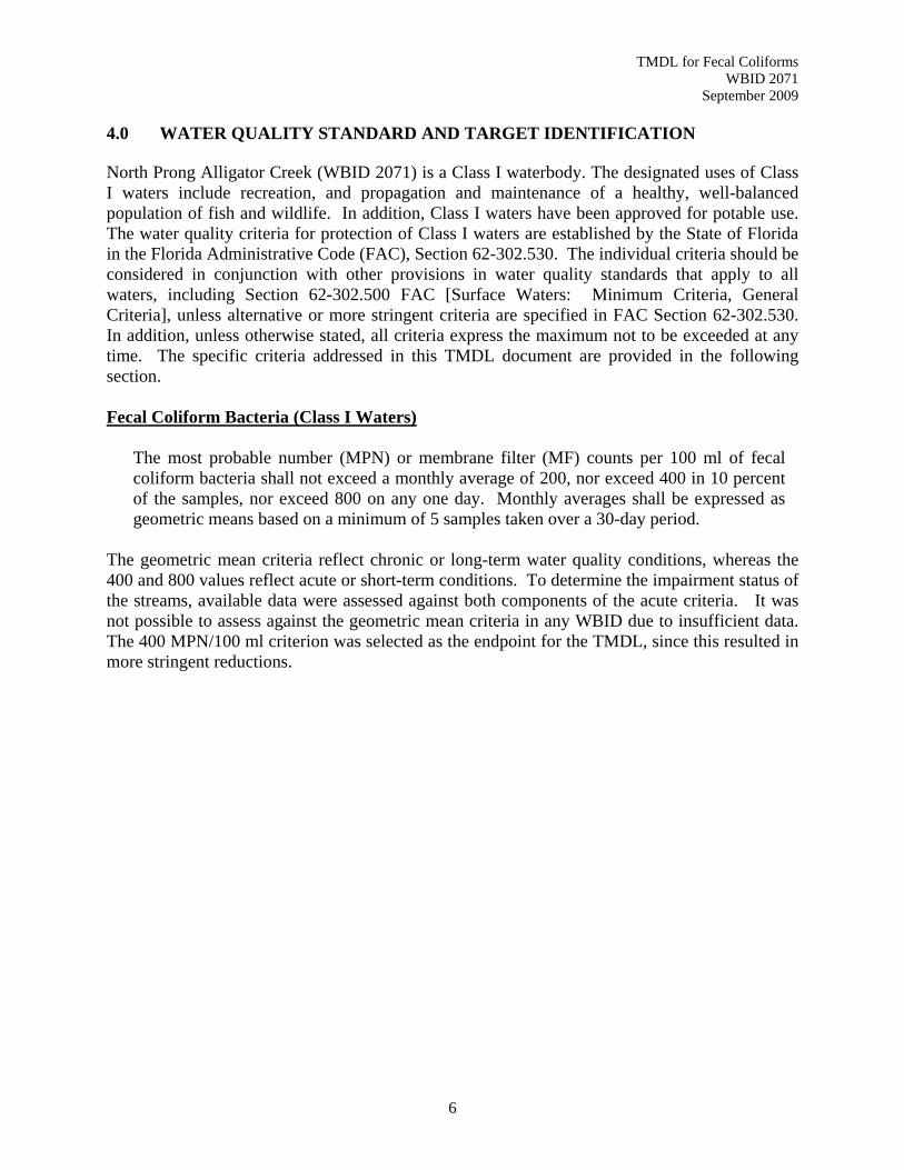
September 2009 4.0 WATER QUALITY STANDARD AND TARGET IDENTIFICATION North Prong Alligator Creek (WBID 2071) is a Class I waterbody. The designated uses of Class I waters include recreation, and propagation and maintenance of a healthy, well-balanced population of fish and wildlife. In addition, Class I waters have been approved for potable use. The water quality criteria for protection of Class I waters are established by the State of Florida in the Florida Administrative Code (FAC), Section 62-302.530. The individual criteria should be considered in conjunction with other provisions in water quality standards that apply to all waters, including Section 62-302.500 FAC [Surface Waters: Minimum Criteria, General Criteria], unless alternative or more stringent criteria are specified in FAC Section 62-302.530. In addition, unless otherwise stated, all criteria express the maximum not to be exceeded at any time. The specific criteria addressed in this TMDL document are provided in the following section. Fecal Coliform Bacteria (Class I Waters)
The most probable number (MPN) or membrane filter (MF) counts per 100 ml of fecal coliform bacteria shall not exceed a monthly average of 200, nor exceed 400 in 10 percent of the samples, nor exceed 800 on any one day. Monthly averages shall be expressed as geometric means based on a minimum of 5 samples taken over a 30-day period.
The geometric mean criteria reflect chronic or long-term water quality conditions, whereas the 400 and 800 values reflect acute or short-term conditions. To determine the impairment status of the streams, available data were assessed against both components of the acute criteria. It was not possible to assess against the geometric mean criteria in any WBID due to insufficient data. The 400 MPN/100 ml criterion was selected as the endpoint for the TMDL, since this resulted in more stringent reductions.
6

TMDL for Fecal Coliforms WBID 2071
September 2009
5.0 FECAL COLIFORM TMDL
This section of the report details the development of the fecal coliform TMDL. Fecal coliform bacteria are frequently used as indicators of fecal contamination since they are abundant in the intestines and feces of animals and people. 5.1 Water Quality Assessment and Deviation from Target FDEP maintains ambient monitoring stations throughout the basin and allows public access to the monitoring results via the internet in their IWR database. Data collected at monitoring stations within the impaired WBID and reported in IWR Run 35 were used in the analysis. Table 2 provides a list of these monitoring stations. Monitoring results are tabulated in Appendix A. Results having laboratory data qualifiers were used in the TMDL analysis in accordance with Appendix A. A summary of fecal coliform monitoring data collected at each station is provided in Table 3. The greatest occurrence of violations in WBID 2071 occurs at Station 21FLFTM CHARHB0035FTM. Table 2 Monitoring Stations in WBID 2071
Table 3 Summary of Fecal Coliform Monitoring Data in WBID 2071
Violations of the fecal coliform criteria often occur in response to rainfall events. Precipitation data collected at a nearby USGS Gage and plotted with the fecal coliform results to identify the hydrologic conditions under which violations occurred (see Figure 4). In most instances, exceedances of the criteria occur in response to rain events while at other times exceedances occur during dry conditions. Implementation of this TMDL should address controlling nonpoint sources during both wet and dry weather conditions.
7

TMDL for Fecal Coliforms WBID 2071
September 2009
1
10
100
1000
10000
1/1/2005 7/20/2005 2/5/2006 8/24/2006 3/12/2007 9/28/2007
Date
Feca
l Col
iform
(MPN
/100
ml)
0
1
2
3
4
5
6
7
8
9
10
Prec
ipita
tion
(inch
es) 21FLFTM 25010011
21FLFTM CHARHB0035FTM21FLFTM CHARHB0036FTM21FLFTM CHARHB0037FTM21FLGW 27132400 MPN/100 ML Standard800 MPN/100 ML StandardPrecipitation
Figure 4 Comparison of Fecal Coliform Concentrations in North Prong Alligator
Creek and Rainfall at USGS02299484 Big Slough at Wcs-101, North Port, FL 5.2 Source Assessment An important part of the TMDL analysis is the identification of source categories, source subcategories, or individual sources of coliform bacteria in the watershed and the amount of pollutant loading contributed by each of these sources. Sources are broadly classified as either point sources or nonpoint sources. A point source is defined as a discernable, confined, and discrete conveyance from which pollutants are or may be discharged to surface waters. Point source discharges of industrial wastewater and treated sanitary wastewater must be authorized by National Pollutant Discharge Elimination System (NPDES) permits. NPDES permitted facilities, as well as certain urban stormwater discharges such as Municipal Separate Storm Sewer Systems (MS4) areas, some industrial facilities, and construction sites over one acre, are considered primary point sources of coliform bacteria. Typically, excursions of fecal coliform bacteria that occur during periods of reduced rainfall result from a lack of dilution for point source discharges or other sources located close to the waterbody. Nonpoint sources of coliform are diffuse sources that cannot be identified as entering a waterbody through a discrete conveyance at a single location. These sources generally, but not always, involve accumulation of bacteria on land surfaces and wash off as a result of storm events. Typical nonpoint sources of coliform bacteria include:
8

TMDL for Fecal Coliforms WBID 2071
September 2009
• Wildlife • Agricultural animals • Onsite Sewer Treatment and Disposal Systems (septic tanks) • Urban development (outside of Phase I or II MS4 permitted areas)
5.2.1 Point Sources 5.2.1.1 Permitted Facilities A TMDL wasteload allocation (WLA) is given to NPDES permitted facilities discharging to surface waters within an impaired watershed. Facilities that dispose of wastewater by means other than a surface water discharge, such as spray irrigation or underground injection wells, typically treat wastewater to less stringent secondary standards. These facilities would be considered in the load allocation for nonpoint sources. There are currently no facilities permitted to discharge in North Prong Alligator Creek (WBID 2071). 5.2.1.2 Municipal Separate Storm Sewer Systems Permits The 1987 amendments to the Clean Water Act designated certain stormwater discharges as point sources requiring NPDES stormwater permits. The regulated activities involve Municipal Separate Storm Sewer Systems (MS4s), construction sites over one acre, and specific industrial operations. Although these types of stormwater discharges are now considered point sources with respect to permitting and TMDLs, they behave similarly to nonpoint sources in that they are driven by rainfall-runoff processes leading to the intermittent discharge of pollutants from land use activities in response to storms. According to 40 CFR 122.26(b)(8), an MS4 is defined as “a conveyance or system of conveyances (including roads with drainage systems, municipal streets, catch basins, curbs, gutters, ditches, man-made channels, or storm drains):
(i) Owned or operated by a State, city, town, borough, county, parish, district, association, or other public body (created by or pursuant to State law)...including special districts under State law such as a sewer district, flood control district or drainage district, or similar entity, or an Indian tribe or an authorized Indian tribal organization, or a designated and approved management agency under section 208 of the Clean Water Act that discharges into waters of the United States. (ii) Designed or used for collecting or conveying stormwater; (iii) Which is not a combined sewer; and (iv) Which is not part of a Publicly Owned Treatment Works.
In 1990, EPA developed rules establishing Phase I of the NPDES stormwater program, designed to prevent harmful pollutants washed into MS4s by stormwater runoff, or dumped directly into them, from being delivered to local waterbodies. Phase I of the program required operators of “medium” and “large” MS4s (generally serving populations of 100,000 or more) to implement a stormwater management program as a means of controlling polluted discharges. Approved stormwater management programs for medium and large MS4s are required to address a variety of water quality related issues including roadway runoff management, municipal owned
9

TMDL for Fecal Coliforms WBID 2071
September 2009 operations, and hazardous waste treatment, etc. Because the master drainage systems of most local governments in Florida are interconnected, EPA implemented Phase 1 of the MS4 permitting program on a countywide basis, which brings in all cities, Chapter 298 urban water control districts, and the Florida Department of Transportation throughout the 15 counties meeting the population criteria. Phase II of the NPDES stormwater rule extended coverage to certain “small” MS4s and to construction sites between one and five acres. Small MS4s are defined as any municipal stormwater collection system that does not meet the criteria of a medium or large MS4 covered by Phase I. Only a select subset of small MS4s requires an NPDES stormwater permit. These “regulated small MS4s” include those located in "urbanized areas" as defined by the Bureau of Census, and other small MS4s designated by NPDES permitting authorities. In October 2000, US EPA authorized FDEP to implement the NPDES stormwater program in all areas of Florida except Indian tribal lands. FDEP’s authority to administer the NPDES program is set forth in Section 403.0885, FS. The three major components of NPDES stormwater regulations are:
• MS4 permits that are issued to entities that own and operate master stormwater systems, primarily local governments. Permittees are required to implement comprehensive stormwater management programs designed to reduce the discharge of pollutants from the MS4 to the maximum extent practicable. • Stormwater associated with industrial activities, which is regulated primarily by a multisector general permit that covers various types of industrial facilities. Regulated industrial facilities must obtain NPDES stormwater permit coverage and implement appropriate pollution prevention techniques to reduce contamination of stormwater. • Construction activity general permits for projects that ultimately disturb one or more acres of land and which require the implementation of stormwater pollution prevention plans to provide for erosion and sediment control during construction.
North Prong Alligator Creek (WBID 2071) is within the Phase I MS4 permitted area for Charlotte County (FLR04E043). 5.2.2 Nonpoint Sources 5.2.2.1 Agriculture Agriculture is a potential source of coliform delivery to streams, including runoff of manure from pastureland and cropland, and direct animal access to streams. Almost 11 percent of the area draining to North Prong Alligator Creek is classified as agriculture, half of which is cropland and pastureland, and the other half is tree farms (Table 1 and Figure 3).
10

TMDL for Fecal Coliforms WBID 2071
September 2009 The USDA National Agricultural Statistics Service (NASS) compiles Census of Agriculture data by county for virtually every facet of U.S. agriculture (USDA NASS, 2007). The “Census of Agriculture Act of 1997” (Title 7, United States Code, Section 2204g) directs the Secretary of Agriculture to conduct a census of agriculture on a 5-year cycle collecting data for the years ending in 2 and 7. Livestock inventory from the 2007 Census of Agriculture reports for Charlotte County is listed in Table 4. Cattle and goats are the predominate livestock in the area of concern. Table 4 Livestock Inventory by County (NASS, 2007)
5.2.2.2 Wildlife Wildlife deposit bacteria in their feces onto land surfaces where it can be transported during storm events to nearby streams, or they may deposit their feces directly into the waterbody or stream. Bacteria loads from wildlife are generally assumed to represent background concentrations, since the contribution from this source is small relative to the load from urban and agricultural areas; however, due to the significant presence of wetlands (23 percent) and other prime habitat for wild animals in both WBIDs, it should be considered as a possible source of significant loading. Water fowl (e.g., herons, ducks, geese, loons) often frequent storm-water ponds and other bodies of water. Depending on the number of birds, the contributions of fecal coliform could result in stream concentrations above the criteria.
5.2.2.3 Onsite Sewerage Treatment and Disposal Systems (Septic Tanks) Onsite sewage treatment and disposal systems (OSTDs) including septic tanks are commonly used where providing central sewer is not cost effective or practical. When properly sited, designed, constructed, maintained, and operated, OSTDs are a safe means of disposing of domestic waste. The effluent from a well-functioning OSTD is comparable to secondarily treated wastewater from a sewage treatment plant. When not functioning properly, OSTDs can be a source of nutrients (nitrogen and phosphorus), pathogens, and other pollutants to both ground water and surface water. Approximately 19 percent of North Prong Alligator Creek’s land use is Urban, with primarily being low density development. This could potentially be a source of fecal coliform bacteria. The State of Florida Department of Health publishes septic tanks data on a county by county basis (www.doh.state.fl.us/environment/ostds/statistics/ostdsstatistics.htm). Table 5 summarizes the cumulative number of septic systems installed since the 1970 census. The data does not reflect septic tanks removed from service.
11

TMDL for Fecal Coliforms WBID 2071
September 2009 Table 5 County Estimates of Septic System Installations
5.2.2.4 Urban Development Urban land uses include residential, industrial, extractive and commercial categories. Fecal coliform loading from urban areas (whether within an MS4 jurisdiction or not) is attributable to multiple sources including stormwater runoff, leaks and overflows from sanitary sewer systems, illicit discharges of sanitary waste, runoff from improper disposal of waste materials, leaking septic systems, and domestic animals. In 1982, Florida became the first state in the country to implement statewide regulations to address the issue of nonpoint source pollution by requiring new development and redevelopment to treat stormwater before it is discharged. The Stormwater Rule, as outlined in Chapter 403 of the Florida Statutes (FS), was established as a technology-based program that relies upon the implementation of Best Management Practices (BMPs) that are designed to achieve a specific level of treatment (i.e., performance standards) as set forth in Chapter 62-40, FAC. Florida’s stormwater program is unique in having a performance standard for older stormwater systems that were built before the implementation of the Stormwater Rule in 1982. This rule states: “the pollutant loading from older stormwater management systems shall be reduced as needed to restore or maintain the beneficial uses of water” (Section 62-40-.432 (5) (c), FAC). In 1994, state legislation created the Environmental Resource Permitting program to consolidate stormwater quantity, stormwater quality, and wetlands protection into a single permit. Presently, the majority of environmental resource permits are issued by the state’s water management districts, although DEP continues to issue permits for specific projects. Nonstructural and structural BMPs are an integral part of Florida’s stormwater programs. Nonstructural BMPs, often referred to as “source controls”, are those that can be used to prevent the generation of NPS pollutants or to limit their transport off-site. Typical nonstructural BMPs include public education, land use management, preservation of wetlands and floodplains, and minimizing impervious surfaces. Technology-based structural BMPs are used to mitigate the increased stormwater peak discharge rate, volume, and pollutant loadings that accompany urbanization. There are a few areas with low density residential areas (10 percent), and an MS4 within North Prong Alligator Creek. It is possible that some of the fecal coliform bacteria are coming into the stream from MS4 runoff. This should be studied as a possible means for fecal coliform bacteria to enter the stream.
12

TMDL for Fecal Coliforms WBID 2071
September 2009 5.3 Analytical Approach The approach for calculating coliform TMDLs depends on the number of water quality samples and the availability of flow data. When long-term records of water quality and flow data are not available, the TMDL is expressed as a percent reduction. Load duration curves are used to develop TMDLs when significant data are available to develop a relationship between flow and concentration. Flow measurements are not available for WBID 2071, nor were sufficient information available to estimate flow. Complicating flow estimation matters more, there are large areas of wetlands in WBID 2071. Hydrologically speaking, wetland soils behave differently than other types of soils. Ultimately it was determined that the TMDL should be expressed as a percent reduction. 5.3.1 Percent Reduction Approach for TMDL Development The percent reduction required to meet the TMDL endpoint is based on the following equation:
[ ] [ ][ ] 100%Reduction ×⎟⎟
⎠
⎞⎜⎜⎝
⎛ −=
existingcriterionexisting
Where: % Reduction = percent reduction [existing] = existing concentration [criterion] = criterion concentration (i.e. target)
Since the water quality standard for fecal coliform bacteria states that up to 10 percent of samples are allowed to exceed a concentration of 400 MPN/100 ml, the existing condition of the waterbody should be represented using a percentile slightly higher than the 90th, in order to ensure that less than 10 percent of the values exceed the criterion. A 90th percentile concentration implies that 90 percent of the measured values are lower than this concentration, and 10 percent are higher. For these TMDLs, the 95th percentile of fecal coliform measurements for each waterbody was calculated and compared against a target of 400 MPN/100 ml. This would meet the water quality standard and provide a margin of safety by ensuring that only 5 percent of the data exceed a concentration of 400 MPN/100 ml. Percent reductions were also calculated using the maximum concentration measured in each WBID to represent the existing condition and the 800 MPN/100 ml criterion as the target. The larger of the two percent reduction values was selected as the TMDL. In the North Prong Alligator Creek TMDL calculation, the existing conditions are represented by the 95th percentile fecal coliform concentration, and percent reductions are calculated to meet the 400 MPN/100 ml acute criterion, since that resulted in higher reduction. There are many formulas for calculating percentiles and these can be found in text books on statistics. The Hazen formula was used to calculate the 95th percentile, as it is recommended in Hunter’s Applied Microbiology (2002) article on bacteria in water. Application of the Hazen formula to data collected at North Prong Alligator Creek is provided in Appendix A.
13

TMDL for Fecal Coliforms WBID 2071
September 2009 5.4 Development of Total Maximum Daily Loads
The TMDL process quantifies the amount of a pollutant that can be assimilated in a waterbody, identifies the sources of the pollutant, and recommends regulatory or other actions to be taken to achieve compliance with applicable water quality standards based on the relationship between pollution sources and in-stream water quality conditions. A TMDL can be represented as the sum of all point source loads (WLA), nonpoint source loads (LA), and an appropriate margin of safety (MOS), which takes into account any uncertainty concerning the relationship between effluent limitations and water quality:
MOSLAsWLAsTMDL +∑+∑=
The objective of a TMDL is to allocate loads among all of the known pollutant sources throughout a watershed so that appropriate control measures can be implemented and water quality standards achieved. 40 CFR §130.2 (i) states that TMDLs can be expressed in terms of mass per time (e.g. pounds per day), toxicity, or other appropriate measure. The fecal coliform TMDL for North Prong Alligator Creek (WBID 2071) is expressed as a percent reduction.
5.4.1 Critical Conditions The critical condition for nonpoint source coliform loading is an extended dry period followed by a rainfall runoff event. During the dry weather period, coliforms build up on the land surface, and are washed off by rainfall. The critical condition for point source loading occurs during periods of low stream flow when dilution is minimized. Water quality data have been collected during both time periods. Most violations occur in response to rain events; however, this is not always the case as North Prong Alligator Creek violated the standard during both wet and dry periods. Critical conditions are accounted for in the analyses by using the entire period of record of measured water quality data available for each WBID, and by using the largest percent reduction to represent the pollutant reduction required year-round, for the entire watershed. By achieving this reduction, water quality standards should be achieved during all other time periods.
5.4.2 Existing Conditions Existing conditions characterize the current water quality conditions of a waterbody. The existing condition of the North Prong Alligator Creek is being conservatively represented using the 95th percentile of measured concentrations. Fecal coliform samples collected in WBID 2071, as well as the 95th percentile and percent reduction required to meet the TMDL target, are shown in Table 6.
14

TMDL for Fecal Coliforms WBID 2071
September 2009 Table 6 Fecal Coliform Measurements in North Prong Alligator Creek (WBID 2071)
Notes: Remark Code B means t that the colony counts were made outside of the acceptable range. Remark Code J means the value was estimated, and that it is not the result of an analytical error. Remark Code L means that the sample was off-scale high, and the value is higher than what is reported. All data were included in the analysis as reported.
5.5 Margin of Safety TMDLs shall include a margin of safety (MOS) that takes into account any lack of knowledge about the pollutant loading and in-stream water quality. In this case the lack of knowledge concerns the data, and how well it represents the true water quality. There are two methods for incorporating a MOS in the analysis: 1) implicitly incorporate the MOS using conservative assumptions to develop allocations; or 2) explicitly specify a portion of the TMDL as the MOS and use the remainder for allocations. In the North Prong Alligator Creek TMDL, an implicit MOS was used by targeting reductions that will result in no more than 5 percent of the samples exceeding a concentration of 400 MPN/100 ml even though the standard requires less than 10 percent exceedance. It should be noted, that in the case of North Prong Alligator Creek, a very large portion of the reduction will need to come from non point sources.
15

TMDL for Fecal Coliforms WBID 2071
September 2009 5.6 TMDL Determination The TMDL values represent the maximum daily load the stream can assimilate and maintain water quality standards. The TMDL was determined from the percent reductions required to meet the daily 800 MPN/100 ml WQS and the 400 MPN/100 ml WQS not to be exceeded in more than 10 percent of the samples for Class I waters. The TMDL reductions that are required to meet both components of the acute criteria for North Prong Alligator Creek are summarized in Table 7. Table 7 TMDL Summary
Notes: 1) The WLA is typically separated into the components originating from continuous NPDES facilities (e.g. WWTPs) and from Municipal Separate Storm Sewers (MS4). WLAs are provided because North Prong Alligator Creek is within an MS4. 2) Overall percent reduction required to achieve the 400 MPN/100 ml fecal coliform criterion. The Margin of Safety is implicit and does not take away from the TMDL value.
5.6.1 Waste Load Allocation Only NPDES-permitted facilities discharging directly into streams and MS4-permitted urban areas are assigned a WLA. WLAs are expressed separately for municipal and industrial facilities (e.g., WWTPs) and MS4 areas as the former discharge during all weather conditions whereas the latter discharge in response to storm events. WBID 2071 (North Prong Alligator Creek) is not currently affected by any NPDES permits. The WBID is affected by Charlotte County’s MS4 permit. The MS4 located within the boundary of the watershed will be responsible for reducing its WLA by the percentage specified in the TMDL table. However, the MS4 permittee will only be responsible for reducing the anthropogenic loads associated with stormwater outfalls it owns or over which it otherwise has responsible control. 5.6.2 Load Allocations There are two modes of transport for nonpoint source coliform bacteria loading into the stream. First, fecal coliform loading from failing septic systems and animals in the stream are considered direct sources of coliform to the stream, since they are independent of precipitation. The second mode involves coliform loadings resulting from accumulation on land surfaces transported to streams during storm events. Thus, according to this data, the load allocation of 77 percent reduction for North Prong Alligator Creek should target both direct sources (i.e., failing septic tanks, domesticated animals and livestock in the stream) and rain events since the violations occur during both wet and dry periods.
16

TMDL for Fecal Coliforms WBID 2071
September 2009 5.6.3 Seasonal Variation Seasonality was addressed by using all water quality data associated with the impaired WBID, which was collected during multiple seasons, and where possible over several years. Data for North Prong Alligator Creek was collected throughout 2007, with an additional measurement in 2005. Since data was collected throughout multiple seasons in 2007, it can be assumed that seasonal variability has been examined. 5.7 Recommendations It is recommended that flow be measured at the time of sampling so that loads can be calculated. Determining the source of bacteria in waterbodies is the initial step to implementing a coliform TMDL. FDEP employs the Basin Management Action Plan (B-MAP) as the mechanism for developing strategies to accomplish the necessary load reductions. Components of a B-MAP are:
• Allocations among stakeholders • Listing of specific activities to achieve reductions • Project initiation and completion timeliness • Identification of funding opportunities • Agreements • Local ordinances • Local water quality standards and permits • Follow-up monitoring
17

TMDL for Fecal Coliforms WBID 2071
September 2009
REFERENCES
Florida Administrative Code (F.A.C.). Chapter 62-302, Surface Water Quality Standards. Florida Department of Environmental Protection (FDEP), 2002. Basin Status Report, Charlotte Harbor Basin, FDEP Division of Water Resource Management, Group 2 Basin, June 2002. Hunter, P.R. 2002. The Society for Applied Microbiology, Letters in Applied Microbiology. 34. 283–286. USDA, 2007. 2007 Census of Agriculture, Volume 1, Geographic Area Series, Part 9, U.S. Department of Agriculture, National Agricultural Statistics Service. AC02-A-9, April 2009. USEPA, 1991. Guidance for Water Quality –based Decisions: The TMDL Process. U.S. Environmental Protection Agency, Office of Water, Washington, DC. EPA-440/4-91-001, April 1991.
18

TMDL for Fecal Coliforms WBID 2071
September 2009
APPENDIX A: WATER QUALITY DATA ANALYSIS
19

TMDL for Fecal Coliforms WBID 2071
September 2009 Table A-1 Guide to Water Quality Remark Codes (Rcode column in data tables) Remark Code
Definition Use in TMDL
A Value reported is mean of two or more samples
Data included in analysis as reported
B Result based on colony counts outside the acceptable range
Data included in analysis as reported
E Extra sample taken in compositing process Data included as average I The value reported is less than the practical
quantification limit and greater than or equal to the method detection limit.
Data included in analysis as reported
J Estimated. Value shown is not a result of analytical measurement.
Data included in analysis as reported
K Off-scale low. Actual value not known, but known to be less than value shown
Data included in analysis as reported
L Off-scale high. Actual value not known, but known to be greater than value shown
Data included in analysis as reported
Q Sample held beyond normal holding time Data used in analysis – holding samples on ice slows the metabolism of the organisms resulting in no appreciable growth. Actual concentration is expected to be at least as high as the value reported.
T Value reported is less than the criteria of detection
Data included in analysis if the reported value is below criteria; otherwise, reported value is not used in the analysis
U Material was analyzed for but not detected. Value stored is the limit of detection.
Data not included in analysis
< NAWQA – actual value is known to be less than the value shown
Data included in analysis
Z Too many colonies were present to count (TNTC), the numeric value represents the filtration volume
Data not included in analysis
20

TMDL for Fecal Coliforms WBID 2071
September 2009 Table A-2 Fecal Coliform Data and Percentiles for WBID 2071
In this TMDL the Hazen formula was used since it is recommended in Hunter’s Applied Microbiology (2002) article concerning bacteria in water. To calculate the percentile associated with the sample concentrations the data are first sorted by concentration, lowest to highest. A ranking is assigned to each sample, with the lowest concentration having a rank of 1 and the highest concentration having a rank equivalent to the total number of samples collected. The percentile is calculated as follows: Percentile = (Rank – 0.5)/ (total number of samples collected) For example, for WBID 2071 on July 9, 2007 a fecal coliform concentration of 400 MPN/100 ml was measured at station 21FLFTM CHARHB0036FTM. This concentration ranks number 13 out of 25 samples collected in WBID 2071. The associated percentile is calculated as: Percentile = (13-0.5)/25 = 0.50 = 50% This implies that 50 percent of the time the instream concentration is less than 400 MPN/100 ml.
21