for dlp, current affairs magazine & test series related regular … · 2019-08-22 · earth are...
TRANSCRIPT
For DLP, Current Affairs Magazine & Test Series related regular updates, follow us on
www.facebook.com/drishtithevisionfoundation
www.twitter.com/drishtiias

CONTENTS
UNIT-I : GEOMORPHOLOGY
1. Introduction to Geography 3-5
2. Origin of Universe, Earth & Life 6-11
3. Our Earth 12-29
4. Rocks & Minerals 30-32
5. Weathering, Mass Movement & Erosion 33-40
6. Landforms 41-51
7. Soil 52-62
UNIT-II : CLIMATOLOGY
8. Weather & Climate 65-67
9. Composition & Structure of Atmosphere 68-71
10. Distribution of Temperature & Heat Budget 72-80
11. Pressure & Wind Systems 81-100
12. Condensation & Precipitation 101-108
13. ClassificationofClimate 109-114
UNIT-III : OCEANOGRAPHY
14. Oceans 117-130
15. Oceanic Resources 131-136
UNIT-IV : HUMAN & ECONOMIC GEOGRAPHY
16. Population 139-154
17. Human Development 155-160
18. Settlement & Migration 161-173
19. Agriculture 174-201
20. Resources of the World 202-224
21. Location of Industries 225-247
22. Transport 248-254
PRACTICE QUESTIONS 255

Interior of the EarthStudy of interior of earth is generally undertaken by geologists and specialists in Earth
Science. Our current information comes from studies of the paths and characteristics of earthquake waves travelling through the Earth, as well as from laboratory experiments on surface minerals and rocks at high pressure and temperature. Other important data on the Earth's interior come from geological observation of surface rocks and studies of theEarth'smotionsintheSolarSystem,itsgravityandmagneticfields,andtheflowofheat from inside the Earth. Most of the knowledge about the earths interior is largely based on indirect sources. Yet, a part of the information is obtained through direct observations and analysis of materials.
Direct SourcesDirect sources include rock materials from mining areas and molten magma from
volcanic eruptions. Surface rock or the rocks we get from mining areas such as gold mines in South Africa are as deep as 3-4 km. Besides, scientists are working on “Deep Ocean Drilling Project” and “Integrated Ocean Drilling Project”. The deepest drill at Kola, in Arctic Ocean, has reached a depth of 12 km. These projects have provided information about interior of Earth through analysis of materials collected at different depths.
Indirect Sources
Evidence from MeteoritesMeteorites from asteroids and even from other planets help scientists understand all
planets in our solar system, particularly the processes taking place deep inside. Although no one has ever been to the center of Earth, we know from meteorites that Earth has a center, or core, made of nickel and iron metal. The other planets have metal cores as well. During planetary formation, metal sinks to the center of the body, while lighter material formed a rocky crust and mantle around the outside.
Evidences from Temperature, Pressure and Density of Earth’s InteriorThe temperature increases towards the centre of the earth and the rate of increase of
temperature is not uniform from the surface towards the earth’s centre. In the beginning, this increase is at an average rate of 10°C for every 32 meters increase in depth. At such a constant rate of increase in temperature the earth’s interior should be in a molten state. Yet it is not so because the rocks buried under the pressure of several kilometer thickness of overlying rocks melt at higher temperature than similar rocks at the surface. The pressure near the centre is considered 3 to 4 million times the pressure of atmosphere at sea level. The molten material under tremendous pressure conditions acquires the property of a solid and is probably in a plastic state. Due to increase in pressure and presence of heavier
3 OUR EARTH

materials towards the earth’s centre, the density of earth’s layers also goes on increasing. Hence, the materials of the innermost part of the earth are very dense.
Evidences from Seismology (Indirect Source)Seismic waves are the waves of energy caused by sudden breaking of rocks within the
earth or an explosion. They are the energy waves that travel through the earth and are recorded on seismographs. Study of seismic waves provides complete picture of composition of the earth.
These waves are of two types – body waves and surface waves:z� Body Waves: Body waves are generated due to the release of energy at the focus and
move in all directions travelling through the body of the earth. Body waves consist of Primary Waves (P-waves) and Secondary Waves (S-waves).zz Primary Waves (P-waves): P-waves arefirsttoarriveatthesurfaceasthey are fastest. The waves are similar to sound waves (longitudinal wave). They travel through gaseous, liquid and solid materials. P-waves cause rocks to squeeze and stretch.
zz Secondary Waves (S-waves): S-waves can travel only through solid materials. This characteristic of the S-waves has helped scientists to understand the structure of the interior of the earth. S waves cannot pass through liquids, as they get absorbed. They are slower than P-waves and transverse in nature.
z� Surface Waves: When body waves interact with surface rocks new set of waves are generated which are called surface waves. The surface waves are restricted to the earth’s surface. These waves are more destructive. They cause displacement of rocks, and hence, the collapse of structures occurs. These waves are of two types – Love waves and Rayleigh waves.zz Love Waves: Love wave causes surface motions similar to that of S-waves, but with
no vertical component.zz Rayleigh Waves: Rayleigh wave makes a material particle oscillate in an elliptic
path in the vertical plane (with horizontal motion along direction of energy transmission).
z� Concept of Shadow Zone: Ingeophysics,therefractionorreflectionofseismicwavesis used for research into the structure of the earth’s interior; these waves are refracted, reflectedandabsorbedwhenitpassesthroughearth’sinteriors.Thereisachangeinvelocity and course of the waves on crossing the boundaries of different zones inside the earth which are recorded by seismograph giving some idea about earth’s interior. Therearespecificareasontheearthsurfacewherewavesdonotgetrecordedontheseismograph; such zones are called as shadow zones. The seismographs located beyond 145° from epicenter, record the arrival of P-waves, but not that of S-waves. We can recall that S-waves can only travel through solid medium. This indicates that interior
Fig: P and S Waves
Our Earth
World Geography 13
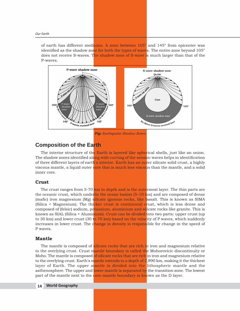
of earth has different mediums. A zone between 105° and 145° from epicenter was identifiedastheshadowzoneforboththetypesofwaves.Theentirezonebeyond105°does not receive S-waves. The shadow zone of S-wave is much larger than that of the P-waves.
Fig: Earthquake Shadow Zones
Composition of the EarthThe interior structure of the Earth is layered like spherical shells, just like an onion.
Theshadowzonesidentifiedalongwithcurvingoftheseismicwaveshelpsinidentificationof three different layers of earth's interior. Earth has an outer silicate solid crust, a highly viscous mantle, a liquid outer core that is much less viscous than the mantle, and a solid inner core.
CrustThe crust ranges from 5-70 km in depth and is the outermost layer. The thin parts are
the oceanic crust, which underlie the ocean basins (5–10 km) and are composed of dense (mafic)ironmagnesium(Mg)silicateigneousrocks,likebasalt.ThisisknownasSIMA(Silica + Magnesium). The thicker crust is continental crust, which is less dense and composed of (felsic) sodium, potassium, aluminium and silicate rocks like granite. This is known as SIAL (Silica + Aluminium). Crust can be divided into two parts: upper crust (up to 30 km) and lower crust (30 to 70 km) based on the velocity of P waves, which suddenly increases in lower crust. The change in density is responsible for change in the speed of P waves.
MantleThe mantle is composed of silicate rocks that are rich in iron and magnesium relative
to the overlying crust. Crust mantle boundary is called the Mohorovicic discontinuity or Moho. The mantle is composed of silicate rocks that are rich in iron and magnesium relative to the overlying crust. Earth's mantle extends to a depth of 2,890 km, making it the thickest layer of Earth. The upper mantle is divided into the lithospheric mantle and the asthenosphere. The upper and lower mantle is separated by the transition zone. The lowest part of the mantle next to the core-mantle boundary is known as the D layer.
Our Earth
World Geography14

CoreThe earthquake wave velocities helped in understanding the existence of the core of the
earth. The core mantle boundary is called Gutenburg Discontinuity located at the depth of 2900km. The core is divided into two parts, a “solid” inner core with a radius of ~1,220 km and a liquid outer core extending beyond it, to a radius of ~3,400 km. Hence, the Inner core exists from 5150 km to 6400 km. The density of material at the mantle core boundary is around 5 g/cm3. At the centre of the earth at 6,300 km, the density value is around 13 g/cm3. The inner core is made up of very heavy material mostly constituted of Nickel and Iron, known as NIFE.
Discontinuities Between Layers
Conrad Continental and Oceanic Crust
Mohorovicic Crust and Mantle
Repetti Upper and Lower Mantle
Gutenberg Mantle and Outer Core
Lehmann Outer and Inner Core
Geomorphic ProcessesIt is a natural process through which the endogenic and exogenic forces causing physical
stressesandchemicalactionsonearthmaterialsbringaboutchangesintheconfigurationon the surface of the earth. It can be either endogenetic/endogenic processes or exogenetic/exogenic processes.
Exogenetic ProcessesThe exogenetic process derive their energy from atmosphere determined by the ultimate
energy from the sun and also the gradients created by tectonic factors. Weathering, mass wasting, erosion and deposition are exogenic geomorphic processes which are later discussed in unit 5 of this Booklet.
Endogenetic/Endogenic ProcessesThe geomorphic processes which are caused by the energy emanating from within the
earth are called endogenic geomorphic processes. This energy is mostly generated by radioactivity, rotational and tidal friction, and primordial heat from the origin of the earth. Endogenic processes are outcome of endogenic forces. Due to variations in geothermal gradients andheat flow fromwithin, crustal thickness and strength, the impacts ofendogenic process are not uniform and hence the tectonically controlled original crustal surface isuneven.Endogenicprocessesare further classified intodiastrophism (Slowprocesses) and catastrophism (Sudden processes).
Fig: Discontinuities
Our Earth
World Geography 15
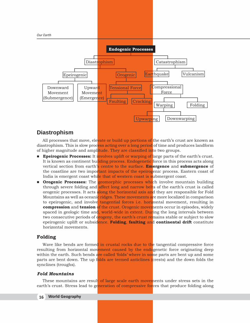
Endogenic Processes
Diastrophism
Epeirogenic
Downward Movement
(Submergence)
Upward Movement
(Emergence)
Tensional Force
Faulting CrackingWarping Folding
Upwarping Downwarping
Compressional Force
Orogenic Earthquake Vulcanism
Catastrophism
DiastrophismAll processes that move, elevate or build up portions of the earth’s crust are known as
diastrophism. This is slow process acting over a long period of time and produces landform ofhighermagnitudeandamplitude.Theyareclassifiedintotwogroups.z� Epeirogenic Processes: It involves uplift or warping of large parts of the earth’s crust.
It is known as continent building process. Endogenetic force in this process acts along vertical section from earth’s centre to the surface. Emergence and submergence of the coastline are two important impacts of the epeirogenic process. Eastern coast of India is emergent coast while that of western coast is submergent coast.
z� Orogenic Processes: The geomorphic processes which involve mountain building through severe folding and affect long and narrow belts of the earth’s crust is called orogenic processes. It acts along the horizontal axis and they are responsible for Fold Mountains as well as oceanic ridges. These movements are more localized in comparison to epeirogenic, and involve tangential forces i.e. horizontal movement, resulting in compression and tension of the crust. Orogenic movements occur in episodes, widely spaced in geologic time and, world-wide in extent. During the long intervals between two consecutive periods of orogeny, the earth’s crust remains stable or subject to slow epeirogenic uplift or subsidence. Folding, faulting and continental drift constitute horizontal movements.
FoldingWave like bends are formed in crustal rocks due to the tangential compressive force
resulting from horizontal movement caused by the endogenetic force originating deep within the earth. Such bends are called ‘folds’ where in some parts are bent up and some parts are bent down. The up folds are termed anticlines (crests) and the down folds the synclines (troughs).
Fold MountainsThese mountains are result of large scale earth movements under stress sets in the
earth’s crust. Stress lead to generation of compressive forces that produce folding along
Our Earth
World Geography16
the lines of weakness. These mountains are also rich storehouse of minerals including tin, copper, gold and petroleum. All the major mountain systems of the world including Himalayas, Alps, Andes, and Rockies etc are young fold mountains.
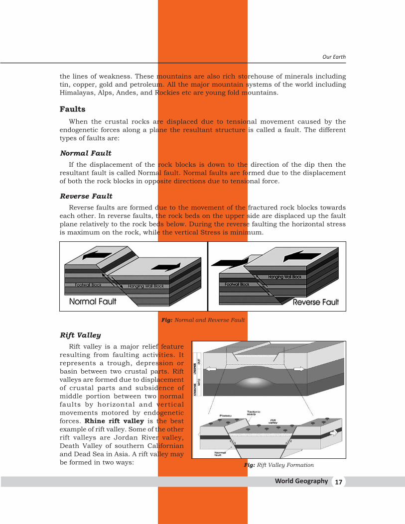
FaultsWhen the crustal rocks are displaced due to tensional movement caused by the
endogenetic forces along a plane the resultant structure is called a fault. The different types of faults are:
Normal FaultIf the displacement of the rock blocks is down to the direction of the dip then the
resultant fault is called Normal fault. Normal faults are formed due to the displacement of both the rock blocks in opposite directions due to tensional force.
Reverse FaultReverse faults are formed due to the movement of the fractured rock blocks towards
each other. In reverse faults, the rock beds on the upper side are displaced up the fault plane relatively to the rock beds below. During the reverse faulting the horizontal stress is maximum on the rock, while the vertical Stress is minimum.
Fig: Normal and Reverse Fault
Rift ValleyRift valley is a major relief feature
resulting from faulting activities. It represents a trough, depression or basin between two crustal parts. Rift valleys are formed due to displacement of crustal parts and subsidence of middle portion between two normal faults by horizontal and vertical movements motored by endogenetic forces. Rhine rift valley is the best example of rift valley. Some of the other rift valleys are Jordan River valley, Death Valley of southern Californian and Dead Sea in Asia. A rift valley may be formed in two ways: Fig: Rift Valley Formation
Our Earth
World Geography 17