for discussion purposes only master plan · 2016. 5. 6. · significant new development, including...
TRANSCRIPT

MASTER PLANCity of New Buffalo, MI
WORKING DRAFTFor Discussion Purposes Only
April 2016

INTRODUCTIONTABLE OF CONTENTS
2 Community Profile
1 Introduction
3 Community Outreach
4 Land Use & Development
5 Transportation & Mobility
6 Community Facilities
7 Parks, Recreation & Environmental Features
8 Implementation
10
2
20
30
54
66
74
84
WORKING DRAFTFor Discussion Purposes Only

INTRODUCTIONTABLE OF CONTENTS
2 Community Profile
1 Introduction
3 Community Outreach
4 Land Use & Development
5 Transportation & Mobility
6 Community Facilities
7 Parks, Recreation & Environmental Features
8 Implementation
10
2
20
30
54
66
74
84
WORKING DRAFTFor Discussion Purposes Only

The City of New Buffalo is well
established as a vacation destina-
tion, drawing visitors and season-
al residents from throughout the
Midwest and beyond. For decades,
the sandy shores of Lake Michigan
and the charming Downtown full of
shops and restaurants have provided
the ideal spot for summer vacation-
ing, boating and beach activities,
and family-oriented fun. This “Small
Town on the Big Lake” has the
foundation of amenities, appeal, and
opportunity upon which this Master
Plan will set a course for the future.
In recent years, New Buffalo has seen
significant new development, including
waterfront condominiums and townho-
mes, infill single-family and new residen-
tial neighborhoods, restaurant and retail
activity, and mixed-use development.
However, as the waterfront, downtown,
and marina areas of town have intensi-
fied, other areas of the City have expe-
rienced a slowdown of development
interest and investment.
Many of the older and more rural neigh-
borhoods are showing signs of disinvest-
ment, as the City’s permanent population
has experienced a 30% decrease in the
past 15 years (from 3,200 down to 1,800).
Also, some key Downtown sites are
sitting vacant, as development on some
projects has stalled. These vacant sites,
stalled development projects, and tired/
aging infrastructure and streetscape
improvements have collectively created
a community that is both attractive to
new development, and at the same time,
telegraphing neglect and past miss steps.
Momentum, however, is on the City’s
side. With a renewed interest and com-
munity support, the City is prepared
to make the commitment, make the
changes, and make the investments
necessary to make a difference. A revi-
talized Downtown and Lakefront that is
warm, welcoming, vibrant and attractive;
Neighborhoods that are stable, accom-
modating, desirable, and improving; and
a local economy that is strong, thriving,
year round, and growing – these are the
hallmarks of the future of the New Buffa-
lo community.
As growth continues to occur, the
community needs a common vision
and guide to ensure local values are
sustained and objectives are met. This
Master Plan articulates that vision and
serves as that guide. It is a foundation
for decision-making related to land use
and development, zoning, transportation
and mobility, community facilities and
services, image and identity, and more.
The Comprehensive Plan is the culmina-
tion of a multi-step planning process and
is based on detailed analysis of the New
Buffalo community as well as extensive
community outreach and engagement.
2 IntroductionWORKING DRAFTFor Discussion Purposes Only
Houseal Lavigne Associates

PURPOSE OF THE MASTER PLANA Master Plan provides guidance for
growth, development, and physical im-
provements within a municipality. The
document is reflective of the commu-
nity it serves, utilizing extensive public
engagement to identify the unified vision
residents have for their future. Based on
foundational analysis, the Master Plan
offers tangible recommendations and
action items that can be undertaken to
achieve the City’s vision.
At its foundation, a Master Plan is a
“how-to” guide that assists with land
use patterns, economic development,
mobility and access, community ame-
nities and services, and management of
parks and natural resources. Community
outreach is a core element of the Master
Plan, with opportunities throughout the
planning process for residents, business
owners and operators, City staff, elected
and appointed officials, and community
stakeholders to voice their opinion and
provide feedback.
The New Buffalo Master Plan is:
f A basis for regulatory actions: The
plan serves as a foundation and guide
for the provisions of the zoning reg-
ulations, subdivision regulations, the
official map, annexation and growth,
and other decisions made under these
regulations.
f A basis for community programs and
decision making: The plan is a guide
and resource for the recommenda-
tions contained in a capital budget
and program, for a community devel-
opment program, and for direction
and content of other local initiatives,
such as for water protection, recre-
ation or open space land acquisition,
housing, and much more.
f A source for planning studies: Master
Plans can’t address every issue in
sufficient detail. Therefore, the plan
will recommend further studies to
develop courses of action for specific
needs.
f A standard for review at the Coun-
ty and State level: Other regulatory
processes identify the municipal plan
as a standard for review of applica-
tions. The Master Plan is important to
the development of regional plans or
inter-municipal programs.
f A source of information: The plan is
a valuable source of information for
local boards, commissions, organiza-
tions, citizens, and business.
f A long-term guide: The plan is a
long-term guide by which to measure
and evaluate public and private pro-
posals that affect the physical, social,
and economic environment of the
community.
3IntroductionWORKING DRAFTFor Discussion Purposes Only
Houseal Lavigne Associates

VISION & CORE STRATEGIESThe Vision for New Buffalo is to be a
beautiful and welcoming community
with a thriving year round local econ-
omy; a vibrant, active and engaging
Downtown; an easily accessible and
family-friendly lakefront and beech area;
attractive and successful commercial
corridors; safe, desirable, and accommo-
dating neighborhoods; and a community
environment that prioritizes pedestrian
and bicycle mobility.
Collectively, all of these components
will strengthen the overall quality of life
in New Buffalo, for both residents and
visitors. Although each and every aspect
of the community’s vision is interrelated,
with each component affecting the other,
the vision can best be achieved over
time by prioritizing four core strategies.
Throughout the Master Plan, recom-
mendations, designations, and initiatives
should all reinforce, in some way, the
four Core Strategies.
CORE STRATEGY ONE: REVITALIZE THE DOWNTOWN & LAKEFRONTNew Buffalo’s Downtown and lakefront
area is the heart of the community,
acting as the primary activity center, a
key destination for residents and tourists
alike, and the core of commercial uses
within the City. The Downtown and lake-
front represent the symbolic heart of the
City and represents a defining character-
istic of the community. The City should
prioritize Downtown New Buffalo as the
center for investment, development,
aesthetic improvement, demonstrating a
dedication to revitalization of the area as
a local and regional destination.
Lake Michigan and the beautiful sandy
beaches along its shores are among the
most amazing and important ameni-
ties nature has to offer. As stewards of
these treasures, the City must protect
them, provide access to them, support
and nourish enjoyment of them, and
make them available to all, including
maintaining the views and vistas to the
Lake, shoreline, and horizon from public
rights-of-way and gathering areas.
4 IntroductionWORKING DRAFTFor Discussion Purposes Only
Houseal Lavigne Associates

CORE STRATEGY TWO: DEVELOP A YEAR ROUND ECONOMYNew Buffalo has historically developed
as a resort community, boasting as a
destination for beachfront recreation
within southwest Michigan as well as the
Chicago region. Although New Buffalo
has benefitted from related growth, the
status of vacation destination comes with
a seasonal drawback. New Buffalo sees
a considerable increase in population
and activity during the summer months;
however, activity greatly decreases
during the “off-season.” New Buffalo’s
seasonal pattern has greatly affected land
use and development within the City, as
well as other elements of the communi-
ty. As the City continues to develop, the
existing seasonal economy will continue
to influence the feasibility and success
of new investment. The City should take
steps to capitalize on the benefits of be-
ing a resort city while aiming to create a
year-round economy, which can support
further employment and growth in the
community.
For local commercial businesses, the
seasonal economy is a lure and a chal-
lenge. Businesses benefit from a highly
profitable summer season in which many
companies make a majority of their an-
nual profit. However, the off-season can
be a struggle. During the fall, winter, and
spring months many local restaurants
and shops choose or are forced to close
due to slow business.
To create a more stable business com-
munity, the City should take steps to
establish a year-round economy by three
means: 1) extending the tourist season
by offering more off-season events,
activities, and attractions, and strategi-
cally marketing the City as a year-round
vacation and visitor destination; 2) devel-
opment of new commercial and employ-
ment based uses that are non-seasonal
in nature; and 3) increase the permanent
population by providing greater hous-
ing options and affordability, as well as
increased employment opportunity.
CORE STRATEGY THREE: STRENGTHEN NEIGHBORHOODS & HOUSINGAccording to population estimates, the
City of New Buffalo has lost a third of its
population in the last decade. This de-
crease is largely attributed to the conver-
sion of permanent residential properties
into rental properties and vacation or
summer homes. While this has facilitated
investment within the community, many
permanent residents are unable to afford
the increased cost of living in New Buffalo
as resort-styled vacation homes and living
options increase property values. This
shift in the use of residential properties
has contributed to a further dip in activity
during the non-summer months.
5IntroductionWORKING DRAFTFor Discussion Purposes Only
Houseal Lavigne Associates

New Buffalo is home to well established
residential neighborhoods offering a range
of housing options. Residential uses locat-
ed between the Amtrak railroad and Lake
Michigan tend toward resort and vacation
styled developments, including numerous
vacation homes and rental properties.
Over time, the location of these properties,
including adjacent residential neighbor-
hoods has greatly increased their market
value. Neighborhoods further from the
Lake, like those south of Red Arrow High-
way, are less impacted by seasonal home
investment. A focus going forward should
be to manage residential growth related
to the tourism industry while developing
affordable housing options to attract and
retain a greater permanent, year-round
population, and strengthen the residential
neighborhoods in all areas of the commu-
nity. Property maintenance, code enforce-
ment, infrastructure enhancements, and
more are needed to further improve the
quality of existing neighborhoods.
CORE STRATEGY FOUR: PRIORITIZE PEDESTRIAN & BICYCLE MOBILITYWhether its connecting the Downtown
to the lakefront, the neighborhoods to
the beach and shopping areas, students
to the schools, or residents and visitors to
the regional bike trail network, the City
should prioritize pedestrian and bicy-
cle mobility throughout every corner of
the community. In the warmer months,
walking is the preferred mode of travel
for residents, visiting vacationers, and
seasonal residents, especially in the
Downtown, lakefront, and surrounding
neighborhood areas.
Two primary goals drive the need for
enhanced pedestrian connectivity: 1)
providing the best possible pedestrian
environment for the lakefront, Down-
town, and core neighborhoods; and 2)
safe routes to schools. These two com-
munity priorities should dictate the in-
vestment into enhanced and thoroughly
connected sidewalk system in key areas
of the City.
Additionally, a complete bicycle network
comprised of trails, on-street lanes, and
on-street routes should safely provide
for bicycling as a safe means of daily
transportation, as well as a recreational
activity connecting the City to the greater
regional bike trail network.
6 IntroductionWORKING DRAFTFor Discussion Purposes Only
Houseal Lavigne Associates

PLANNING PROCESSNew Buffalo’s Master Plan is the prod-
uct of a multi-step, community-driven
planning process designed to produce
a path forward that assesses and builds
on existing conditions and influences,
establishes a vision, and develops policies
and recommendations to serve as a guide
for community decision-making. The
planning process was built on a founda-
tion of community input and outreach,
and focused on both community-wide
and area-specific recommendations. The
planning process for the Comprehensive
Plan comprised seven steps.
STEP 1: PROJECT INITIATIONTo “kick-off” the planning process, meet-
ings were held with key City staff, the
Planning Commission, and City Council.
In addition, a program was developed for
community outreach, including commu-
nity workshops and the launch of online
outreach tools, designed to promote
community involvement and encourage
citizen participation.
STEP 2: EXISTING CONDITIONS ANALYSISThis step included an assessment of the
existing conditions and future potentials
within the community. It was based on
information provided by the City, as well
as feedback from community service
providers and reconnaissance, surveys,
inventories, and analyses undertaken by
the Consultant.
STEP 3: COMMUNITY OUTREACH & ENGAGEMENTCommunity outreach and citizen par-
ticipation were essential components
of developing the New Buffalo Master
Plan. In-person outreach events were
conducted to engage the community,
gathering input to guide plan recom-
mendations and policies. Web-based
activities were also used to complement
traditional outreach, including on-line
questionnaires for residents and busi-
nesses, and input from sMap, an on-line
mapped-based outreach tool.
STEP 4: VISION, GOALS, & OBJECTIVESAn overall “vision” was established for
the future of the City of New Buffalo,
aimed at providing focus and direction
for subsequent planning activities. The
vision includes four primary focuses that
serve as the “cornerstone” of the consen-
sus building process. Based on the vision
and previous steps in the process, goals
and objectives were also prepared for
inclusion in key sections of the plan.
STEP 5: COMMUNITY-WIDE PLANS & POLICIESThis step included the preparation of future
plans for land use and development, trans-
portation and mobility, community facilities,
parks and open space, and environmental
features. These plans provide the “core” for
the Master Plan, reflecting community input
and the City’s goals and objectives.
STEP 6: PLAN DOCUMENTS & ADOPTIONBased on the previous steps in the plan-
ning process, the draft and final versions of
the Master Plan document were prepared
for local review and consideration, includ-
ing a Planning Commission public hearing
on XX/XX/XX. The Plan was presented to
City Council and adopted on XX/XX/XX.
7IntroductionWORKING DRAFTFor Discussion Purposes Only
Houseal Lavigne Associates

WORKING DRAFTFor Discussion Purposes Only

COMMUNITYPROFILE
WORKING DRAFTFor Discussion Purposes Only

The City of New Buffalo has long
been known as the “Gateway to
Michigan,” situated at the south-
western tip of the state and one of
the first municipalities travelers
pass entering into Michigan from
the west. New Buffalo is located less
than 50 miles from Downtown Chi-
cago, where the Galien River flows
into Lake Michigan. New Buffalo
has historically benefitted from its
proximity to the Chicago Metropoli-
tan Area while offering a “get-away”
from the City.
REGIONAL SETTINGNew Buffalo is the largest municipality
contained within New Buffalo Township,
which directly borders the state of Indi-
ana to the south. The Township is part of
the greater Barrien County. The City of
New Buffalo is entirely bordered by un-
incorporated land within the township;
however, other coastal communities are
located nearby, including the Villages of
Grand Beach and Michiana to the south
and the unincorporated community of
Union Pier to the north. New Buffalo
Township also includes the Four Winds
Casino located on the Pokagon Indian
Reservation.
The Red Arrow Highway, part of the West
Michigan Pike, runs through New Buffalo
connecting the Chicago region with
municipalities stretching all the way to
Mackinaw City. Once a high traffic road-
way, the construction of Interstate 94 has
decreased traffic while providing greater
regional accessibility for the community.
Amtrak operates a station in New Buffalo
with daily service to Chicago, Detroit, and
numerous other Michigan municipalities.
MICHIANA
LONG BEACH
MICHIGAN CITY
GRAND BEACH
UNION PIER
FOUR WINDSCASINO
NEW BUFFALO
LAKEMICHIGAN
INDIANA
MICHIGAN
ILLINOIS
CHICAGO
NEW BUFFALO
GARY LA PORTE
OAK PARK
EVANSTON
NORTHBROOK
ORLAND PARKMICHIGAN CITY
ST. JOSEPH
O’HARE
MIDWAY
94
57
88
94
94
55
94
94
94
8090
90
90
90
294
290
294
10 Community ProfileWORKING DRAFTFor Discussion Purposes Only
Houseal Lavigne Associates
COMMUNITY HISTORYNew Buffalo was settled in the 1800s;
however, Native Americans from the
Miami and Potawatomi tribes were ob-
served in the area as early as the 1670s.
In October, 1834, Captain Wessel D.
Whittaker’s ship was ran aground during
a violent storm, wrecking near present
day Grand Beach. The Captain and crew
sought shelter in Michigan City, Indiana,
eventually hiring a rig to return to St. Jo-
seph and report the ship’s loss to its un-
derwriters. While travelling north along
the coast, Whittaker was captured by the
beauty of the area, especially where the
Galien River flowed into Lake Michigan.
Upon settling his affairs, Whittaker laid
claim to the land, returning in spring
1835 to settle the Village of New Buffalo
(now City), named after his hometown of
Buffalo, New York.
Early development of Whittaker’s New
Buffalo was mixed, initially marked by a
few years of steady land speculation. The
National Panic of 1837 combined with a
particularly brutal winter in 1841 brought
an end to further speculation. The City
returned to a period of growth with the
completion of the Michigan Central Rail-
road in 1849, which connected Detroit
to New Buffalo as a route to Chicago.
At the time, passengers would travel to
New Buffalo and switch to other modes
of transportation, largely steamships, to
reach Chicago. This facilitated consid-
erable growth and activity in the area,
including new hotels, restaurants, and
shops, as well as improvements to the
harbor to accommodate increased traffic.
In 1953, the railroad line was extended
through Indiana to provide direct access
to Chicago, ending a period of vitality in
New Buffalo.
COMMUNITY IDENTITYWhile development was limited, the City
continued to grow through the latter half
of the 1800s. In the early 1900s, the City
developed a new image, recognized as a
resort and vacation destination. This fa-
cilitated new restaurants, shops, and hos-
pitality accommodations geared toward
tourism. Over the years, New Buffalo has
retained its identity as a popular resort
community, offering lakefront recreation,
regionally recognized restaurants, and a
variety of residential options catering to
tourists.
Growing as a resort community has
created a seasonal effect in New Buffalo,
with tourism picking up during the sum-
mer months and business dipping during
other times of the year. Many restaurants,
shops, and other businesses close during
the harsher winter months, decreasing
activity in the City. In summer months,
a larger population boosted by visitors
places a higher demand on City services
and amenities. In addition, popularity as
a resort destinations has decreased the
City’s permanent population as residen-
tial properties are converted to summer
houses and rental properties.
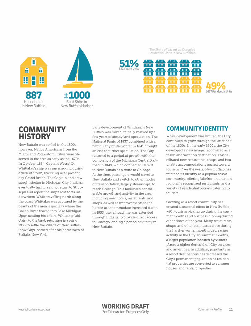
The Share of Vacant vs. OccupiedResidential Units in New Buffalo is:
852 Vacant Units
1667 Residential Units
51%
49%Households
in New BuffaloBoat Ships in
New Buffalo Harbor
887 ±1000
11Community ProfileWORKING DRAFTFor Discussion Purposes Only
Houseal Lavigne Associates

DEMOGRAPHICSThe City of New Buffalo has a 2015
population of 1872 residents. The City’s
population is currently in decline from
roughly 2,800 residents in 1980 to 1883
residents in 2010. Population loss has
been more gradual in the past 10 years,
with projections estimating a 2020
population of 1875. Losses in population
are closely related to the City’s tourism
industry, with residents being bought
out of the community by developers and
individuals looking to create summer
homes and rental properties.
The City sees a seasonal population spike
during the summer vacation months,
which has had a prolonged effect on
housing in the community. While New
Buffalo includes a total of 1,667 housing
units, 51.1% or 852 units are listed as va-
cant, according to the U.S. Census Bureau.
While vacant units do exist, it is likely that
many of these are rental properties and
temporary homes which remain vacant
during the majority of the year.
estimated population lossbetween 2000 and 2010
- 317
19501565
19602128
19702784
19802821
19902317 2000
22002010
18832020
1875
Source: ESRI Business Analyst & CMAP 2040 Projections
Population Change (1950-2020)New Buffalo
12 Community ProfileWORKING DRAFTFor Discussion Purposes Only
Houseal Lavigne Associates

The population of New Buffalo is aging,
with the City’s median age increasing
from 48.4 years old in 2010 to 50.7 years
old in 2015. The median age is project-
ed to further increase to 52 years old by
2020. Individuals over 55 years of age
account for the majority of New Buffalo’s
population at 43%, while youth under 19
years of age account for 18% and young
adults between the ages of 20 and 34
account for only 13%. These trends can be
linked to the City’s seasonal pattern and
status as a “resort” community. The in-
creasing costs of property in New Buffalo
and lack of year-round employers makes
living in New Buffalo difficult for young
adults and new families.
18%
13%
26%
43%
Youth(0-19 years)
YoungAdult
(20-34 years)
MiddleAdulthood
(35-54 years)
Senior(55+ years)
New Buffalo’s Median Age is50.7 years
Source: ESRI Business Analyst
Age Distribution (2015)New Buffalo
13Community ProfileWORKING DRAFTFor Discussion Purposes Only
Houseal Lavigne Associates

PAST PLANS, STUDIES & REPORTSA review of past plans, studies, and re-
ports was conducted to align the Master
Plan with previous planning efforts and
initiatives. This understanding helps
guide the New Buffalo Master Plan and
unite existing planning efforts and docu-
ments. Both local and regional planning
efforts which may have an impact on
New Buffalo have been reviewed.
LOCAL PLANS
New Buffalo Master Plan 2000-2010 (2003)New Buffalo’s previous master planning
effort was completed in 2003, reviewing
the key elements of the City and estab-
lishing a set of goals and objectives to
guide growth and development. Many of
the issues discussed within the plan are
still relevant today, including a focus on
the Downtown, improving access to the
Lakefront, and development of a year-
round community. Where appropriate,
recommendations of the 2003 Master
Plan have been updated and expanded to
better address issues which have persist-
ed in the community.
2014-2024 Master Plan (2014)The City of New Buffalo 2014-2024 Master
Plan is an un-adopted master planning
effort completed with assistance from the
Southwest Michigan Planning Commis-
sion. The Plan provides an important
review of the community including de-
mographics, natural resources, parks and
recreation, education and community fa-
cilities, and transportation. The Master Plan
functions more effectively as an existing
conditions document, stopping short of
specific recommendations and implemen-
tation strategies. Given the recent comple-
tion of this effort; however, the 2014-2024
Master Plan has been used as a resource
throughout the planning process.
Downtown New Buffalo Study (2009)The Downtown New Buffalo Study was
conducted by the Business Improvement
District Board of Directors. The study
was based upon results of a downtown
survey distributed throughout the com-
munity. The study demonstrated a clear
lack of identity to the Downtown, with
respondents noting the area as having no
theme or unified image. In addition, the
basic amenities and infrastructure of the
Downtown were often rated as being in
fair or poor condition. The findings of the
study were used to create the Downtown
Streetscape Plan.
Downtown Streetscape Plan (2010)Utilizing the Downtown New Buffalo
Study, the Downtown Streetscape Plan
provided a detailed inventory of the
Downtown area, looking to address is-
sues emphasized by the community. The
Plan includes detailed design guidelines
for streets within the Downtown study
area, aimed at providing a cohesive char-
acter while improving pedestrian and
bicycle safety. While recommendations
of the Streetscape Plan were never fully
implemented, in 2015 the City initiated
a process to develop a new Streetscape
Plan.
Community Park, Recreation, Open Space, & Greenway Plan (2014-2019)The Community Park, Recreation, Open
Space, and Greenway Plan inventories
and reviews all parks, recreation, and
open spaces within City limits, providing
an action plan for specific improvements
and upgrades. The Plan was used to solic-
it public input, guide future investment,
and identify potential funding sources
for expansion of existing facilities. In
addition, the Plan establishes goals to
maintain and improve existing facilities,
develop new recreational opportunities,
and enhance local partnerships.
14 Community ProfileWORKING DRAFTFor Discussion Purposes Only
Houseal Lavigne Associates

REGIONAL PLANS
Barrien County Master Plan (2009)The Barrien County Master Plan acts as
a guiding document for the entirety of
Barrien County, Michigan, establish-
ing direction for green infrastructure,
economic development, agriculture,
housing, transportation, and infra-
structure. As a county-wide document,
the Plan provides overarching policies
for Barrien County, aiming to protect
natural resources and open spaces while
facilitation healthy growth of existing
communities. New Buffalo resides within
an economic landscape defined as water/
recreation, highlighting the communi-
ties reliance on tourism for economic
development.
Harbor Country Hike & Bike Plan (2010)The Harbor Country Hike & Bike Plan
provides an analysis of existing pedestri-
an and bicycle infrastructure, including
recommendations for new extensions, in
Harbor Country. This area is defined by
the Townships of New Buffalo, Chika-
ming, and Three Oaks including the
municipalities of New Buffalo, Three
Oaks, Grand Beach, and Michiana. The
Plan proposes three non-motorized
pathways moving through the City north
to south, providing connections to Grand
Beach, Michiana, Union Pier, and Three
Oaks. Routes would run within the right-
of-way along Clay Street, Red Arrow
Highway, and through the Downtown via
Whittaker Street to Marequette Drive. An
off-road route was also proposed with a
trailhead at the New Buffalo City Beach.
The Plan also recommends various bike
lanes and sidewalk improvements to
roadways in the City.
Galien Watershed Plan (2003)The Galien Watershed Plan was devel-
oped to address flooding and pollution
concerns for the Galien River. While only
a small portion of the watershed is con-
tained within the City, this includes the
river’s mouth, thus conveying all water
in the system through New Buffalo. The
Plan provides specific recommendations
regarding water quality, wetland preser-
vation and restoration, land use policies,
and hydrology.
15Community ProfileWORKING DRAFTFor Discussion Purposes Only
Houseal Lavigne Associates

THE HARBOR
LAKE MIC
HIGAN
ROSE
CIT
Y
EAGLE
WATER
DETROIT
MERCHANT
BARKER
MICHIGAN
TOWNSEND
BARTON
JAMESON
FRANKLIN
NORTON
MAYHEW
JEFFERSON
OSELKA
SHORE
BRONSON
NORTH
BERRIENM
ARSHALL
BIDDLE
CHICAGO
GRIFFITH
WATER
INDIANA
WILSON
TAYLOR
WASHINGTON
BERRIEN
HARRISONCHICAGO
CITYBEACH
BUFFALO
WHITTAKER
HARBOR COUNTRY
MECHANIC
WILLARD
CLAY
STROMER
MADISON
BELL
BUFFALO
MARQUETTE
12
12
12
239
94
Single-Family Detached
Single-Family Attached
Multi-Family
Mixed Use
Commercial General
Commercial Services
Hotel
Office
Industrial
Light Industrial
Public / Semi-Public
Religious
Open Space
Park
Parking
Railroad / Utilities
Vacant Land
Vacant Builidng
Key
EXISTINGLAND USE
16 Community ProfileWORKING DRAFTFor Discussion Purposes Only
Houseal Lavigne Associates

CITYBEACH
THE HARBOR
LAKE MIC
HIGAN
ROSE
CIT
Y
EAGLE
WATER
DETROIT
MERCHANT
BARKER
MICHIGAN
TOWNSEND
BARTON
JAMESON
FRANKLIN
NORTON
MAYHEW
JEFFERSON
OSELKA
SHORE
BRONSON
NORTH
BERRIENM
ARSHALL
BIDDLE
CHICAGO
GRIFFITH
WATER
INDIANA
WILSON
TAYLOR
WASHINGTON
BERRIEN
HARRISONCHICAGO
BUFFALO
WHITTAKER
HARBOR COUNTRY
MECHANIC
WILLARD
CLAY
STROMER
MADISON
BELL
BUFFALO
MARQUETTE
12
12
12
239
94
R-1 Single Family Residential
R-2 Medium Density Residential
R-3 High Density Residential
PUD Planned Unit Development
FP-1 Floodplain District*
GCD General Commercial District
CBD Central Business District
I-1 General Industrial District
WM Waterfront Marina District
NCD Nature Conservation District
*FP-1 Floodplain District is a special flood hazard area having a one percent chance of flooding in a given year.
Key
CURRENTZONING
17Community ProfileWORKING DRAFTFor Discussion Purposes Only
Houseal Lavigne Associates

18 Community ProfileWORKING DRAFTFor Discussion Purposes Only
Houseal Lavigne Associates

COMMUNITYOUTREACH
WORKING DRAFTFor Discussion Purposes Only

Community outreach is an essential
element of the planning process for
the New Buffalo Master Plan. Pub-
lic engagement provides valuable
input from the individuals who form
the community, helping to create
a baseline understanding for plan-
ning efforts. The issues, concerns,
opportunities, and assets identified
by community stakeholders helped
shape the recommendations and
strategies of the Master Plan, ensur-
ing a document that is relevant and
reflective of the community it serves.
The following is a summary of commu-
nity outreach completed as part of the
planning process. Both in-person and
online outreach efforts have been used to
engage the community, including:
f City Council and Planning Commis-
sion Workshop (25+ in attendance)
f Resident Workshop (30+ in atten-
dance)
f Business Workshop (20+ in atten-
dance)
fOnline Resident Questionnaire (167
responses)
fOnline Business Questionnaire (19
responses)
f sMap-online interactive mapping tool
(11 maps, 71 points of interest)
MAJOR ISSUESThe following is a summary of the major
issues identified throughout all public
outreach, including both in-person and
online opportunities. These issues were
discussed, in various ways, across all out-
reach events and tools, highlighting their
importance for the New Buffalo commu-
nity. Some of the more detailed summa-
ries of individual outreach efforts are also
included following this section.
DOWNTOWN NEW BUFFALOThe Downtown area located along Whit-
taker Street was a central focus through-
out community outreach. Residents
and business owners felt the area lacks
investment, vitality, and excitement. Ma-
jor vacant properties make the area feel
empty, particularly the unfinished de-
velopment between Merchant Street and
Mechanic Street. While seen as the heart
of New Buffalo, community members
want to see new investment and vitality
to make the Downtown a regional draw
and competitor.
THIS SECTION CONTAINS A SUMMARY OF THE THOUGHTS, COMMENTS, AND OPINIONS RECEIVED THROUGHOUT THE COMMUNITY OUTREACH PROCESS. IT IS IMPORTANT TO NOTE THAT THE ITEMS IDENTIFIED IN THIS SUMMARY ARE NOT RECOMMENDATIONS OR OBSERVATIONS OF THE CONSULTANT, BUT RATHER FEEDBACK AND COMMENTS RECEIVED FROM THOSE WHO PARTICIPATED IN THE WORKSHOPS AND ON-LINE OUTREACH ACTIVITIES.
20 Community OutreachWORKING DRAFTFor Discussion Purposes Only
Houseal Lavigne Associates

LAKE MICHIGAN & BEACHFRONTSimilar to the Downtown, Lake Michigan
and the beachfront were highlighted
as a central reason visitors and resi-
dents come to New Buffalo. Participants
argued, however, that the beach has be-
come dated and less appealing than other
beaches in communities along the Lake
Michigan coast. Many noted that plans
have been developed for the lakefront,
but never implemented. Throughout out-
reach participants called for redevelop-
ment and revitalization of the beachfront
to not only improve its entertainment
value but also better integrate it with the
Downtown and community.
ECONOMIC DEVELOPMENTCommunity members demonstrated a
strong desire for new businesses and
development. Residents hope to see new
commercial uses, including restaurants,
retailers, and entertainment businesses,
especially in Downtown. While the City’s
unique small businesses were seen as an
asset, many felt that a lack of investment
is hurting the community and decreas-
ing its prominence within the region. In
some cases this was linked with a need
for a more steady employment base.
YEAR-ROUND ECONOMYClosely linked to economic development
was the need for a year-round econo-
my. Business owners and residents alike
noted that New Buffalo has a seasonal
economy that caters to summer tourism.
In other seasons of the year, however,
companies struggle to bring in patrons
on a regular basis. Many noted that this
has led to seasonal retailers who close for
the off season, creating a perception that
the community is not active during those
months. Business owners and opera-
tors called for new ways to support local
business operation and tourism to bring
in patrons throughout the year.
LOCAL INFRASTRUCTUREThe poor condition of local infrastructure
was a consistent discussion in commu-
nity outreach. While comments were not
limited to any particular area, many older
residential neighborhoods were high-
lighted as having poor maintenance. In
addition, Whittaker Street and the Red Ar-
row Highway were often noted as having
a poor appearance which creates a neg-
ative image of New Buffalo given their
prominence as the City’s two busiest
roadways. Sidewalks were most consis-
tently noted as being poorly maintained
and dangerous for pedestrians.
GOVERNMENT & COMMUNITYMany comments from public engage-
ment noted a lack of effort and urgency
from the local government and commu-
nity. Stakeholders often felt that the local
government was not effectively address-
ing significant issues within the commu-
nity, particularly the unfinished property
in Downtown New Buffalo which has
remained vacant for many years. Also
discussed was a lack of empathy or inter-
est from residents who are unconcerned
about the future of the City. This was
closely tied to the community’s seasonal
tourism, given that many homeowners
don’t live in New Buffalo fulltime. Partici-
pants felt that new energy and focus was
necessary from all stakeholders to bring
about change for the better.
21Community OutreachWORKING DRAFTFor Discussion Purposes Only
Houseal Lavigne Associates

IN-PERSON OUTREACHIn-person events are the core of commu-
nity outreach, providing an opportunity
for stakeholders to publicly discuss issues
facing the City of New Buffalo. These
events enable face-to-face discussion and
pointed questions that are vital to build-
ing an understanding of the community.
Further, in-person outreach helps to
gather not just the important issues and
concepts, but the emotions behind them
which are central to establish a vision for
the City. In addition to an initial kick-
off workshop with the City Council and
Planning Commission, two in-person
outreach events were held in support of
the New Buffalo Master Plan: a Commu-
nity Workshop and a Business Workshop.
WORKSHOP FORMATBoth workshops followed the same
format designed to facilitate discussion
and gather a range of input from partici-
pants. The workshops began with a brief
overview of the planning process and
concluded with a questionnaire exercise,
from which participants shared their
written comments with the overall group.
The exercise included questions relating
to top issues and concerns, important
projects and actions, and community
strengths and assets.
COMMUNITY WORKSHOPOn Monday, July 20, 2015 a workshop
was held for residents and community
stakeholders at the City Hall. Over 30
individuals attended and participated at
the event.
Top Issues & ConcernsAppearance of the Downtown
Workshop participants showed con-
cern for the appearance of New Buffa-
lo’s “downtown” or the Whittaker Street
corridor between Buffalo Street and
the railroad. Many comments regarded
vacancies within the downtown, partic-
ularly the unfinished development on
the northeast side of Whittaker between
Merchant Street and Mechanic Street.
Dubbed “the hole,” the site was noted as
an eyesore, with the vacant, unfinished,
and dilapidated structure detracting from
the visual appearance of the area. Com-
menting that the site has sat unfinished
and poorly maintained for close to a de-
cade, residents expressed a strong desire
for redevelopment.
Additionally, residents called for down-
town streetscaping, façade upgrades,
new awnings, fresh paint, more park-
ing, improved walkability, year-round
businesses and recreational retail, and
other destination-type establishments
including a movie theatre, food vendors,
tourism, a boardwalk and green space.
Participants hope to see life and excite-
ment within the downtown area.
22 Community OutreachWORKING DRAFTFor Discussion Purposes Only
Houseal Lavigne Associates

Outdated infrastructure
In coordination with enhancements
to the appearance of downtown, many
of the participants at the community
workshop indicated a need for citywide
infrastructure repair and enhancements.
Residents cited infrastructure repairs
needed along the lakefront, as well as
the city street network. Although the
lakefront was noted as the city’s best
asset, the workshop as a whole agreed
that infrastructure updates are necessary
to enhance the lakefront to make it even
better. Aside from the desired lakefront
infrastructure enhancements, many par-
ticipants voiced a need for sidewalk and
street repairs; specifically, to widen the
sidewalks and fill in pot holes in the street
network. Additionally, there was a call for
more public restrooms in the downtown
and lakefront areas.
Appearance of Beachfront and Lion’s park
Another top issue discussed was the need
for improvements to the appearance of
the lakefront and Lion’s park. Several
workshop participants suggested bring-
ing in sand to refill the eroded beaches.
Participants described the beachfront as
overall lacking in activity and excitement,
with some commenting that visitors were
choosing beaches in other cities over
New Buffalo. Other argued that, while
the beach was an important attribute,
it remains isolated from other destina-
tions within the city. Given its location
between the downtown, beach, and City
boat launch, Lion’s Park was discussed as
being poorly maintained, uninteresting,
and lacking in overall features.
Reprogram lakefront
Closely related to the appearance of the
beach front, workshop participants ex-
pressed a desire for improved program-
ming along the lakefront to increase the
number of uses the beach and lakefront
can offer. For example, residents envision
a boardwalk, non-motorized boat rentals,
food vendors, a farmers’ market, and a
playground becoming part of the land-
scape. Respondents hoped to see Lion’s
park repositioned to better connect the
beach to the downtown area and provide
a space for community gathers and activ-
ities. The development of new lakefront
programming and activities was linked
the loss of important tourism dollars.
Need for a sustainable economy
Given New Buffalo’s position as a tourist
destination along the coast of Lake
Michigan, residents explained the City’s
struggle with year-round economic
activity. While much of the city includes
part-time residents, those living in the
City full-time residents face limited
opportunities and choices during the
off-season months as retail businesses
and other destinations within the city
shut down temporarily. Additionally,
some participants expressed the need for
integration between permanent and sea-
sonal residents, noting that there is a lack
of heritage development within the City
caused by the lack of social cohesion be-
tween part-time and full-time residents.
Furthermore, participants highlighted a
lack of full-time employment opportuni-
ties due to the seasonal economy.
Lack of a sense of urgency
For many community stakeholders, a key
issue was the lack of a sense of urgency
within the local culture. Many felt that
major concerns need to be address with
immediate action; however, local apathy
or disinterest has reduced the City’s
ability to affectively mitigate these issues.
This was partially linked to New Buffalo’s
status as a “vacation town,” which means
a large amount of the population is not
fully invested in the community’s future.
The large vacant development within
the downtown, which has stood empty
for over a decade, was cited as a clear
example. Respondents hope to see great-
er action and more urgent responses to
local issues moving forward.
23Community OutreachWORKING DRAFTFor Discussion Purposes Only
Houseal Lavigne Associates

BUSINESS WORKSHOPOn Monday, July 20th, 2015 a workshop
was held with over 20 members of the
New Buffalo business community. This
workshop provided business owners
and operators an opportunity to publicly
discuss issues facing The City of New
Buffalo from a business perspective.
Top Issues & ConcernsParking and Public Restrooms
Many business owners explained that
there is a lack of parking and public
restrooms in New Buffalo. Many par-
ticipants expressed frustration with the
longstanding, unfinished development,
dubbed “the hole” on Whittaker. Work-
shop participants stressed the need for
more parking and public bathrooms,
identifying the vacant site at the inter-
section of Whittaker and the Red Arrow
Highway as a potential site. Additionally,
several participants desired a more walk-
able environment in New Buffalo, which
could also influence parking.
Fix Whittaker street development
A large majority of the participants high-
lighted the need to redevelop the vacant,
unfinished development on Whittaker.
The nearly decade-long stalled develop-
ment is left unmaintained causing blight
in the downtown district, which partic-
ipants do not appreciate nor find good
for business. Other workshop comments
included Streetscaping and offering
incentives to develop vacant lots near the
Whittaker street development.
Implement lakefront plans
Another issue identified by the Business
Owners workshop includes timely imple-
mentation of existing plans. Many par-
ticipants feel a lack of urgency from the
city when it comes to implementation of
plans, particularly those relating to the
lakefront and marina. Many hope to see
better use of the area and implementa-
tion of greater placemaking that will help
elevate the character of New Buffalo.
Year-round economic opportunities
Workshop participants identified year-
round economic opportunities as an
issue in New Buffalo. For instance, one
participant noted the lack of reasonable
rent to keep business open all year. In a
tourism-based economy, business reve-
nues significantly drop in the off season,
and a solution is needed to accommodate
this bi-annual fluctuation for year-round
businesses through appropriate leases.
Additionally, business owners described
how off-season vacancies and temporary
shutdowns negatively affect year-round
businesses. One suggested recommen-
dation was to ask seasonal business own-
ers to install nicely decorated storefronts
to be displayed throughout the offseason
rather than leaving a dark, naked building
to sit for months. Also, some business
owners noted a lack of communication
between the City and business.
24 Community OutreachWORKING DRAFTFor Discussion Purposes Only
Houseal Lavigne Associates

ONLINE OUTREACHAs a compliment to in-person outreach
events, online tools were developed to
offer residents additional opportunities
to provide input. Online outreach helps
to capture feedback from those unable to
attend outreach events as well as those
unlikely to attend, responding to a fun-
damental shift in the way individuals in-
teract with their community. Online tools
included questionnaires for community
members and the business community,
as well as sMap, an interactive mapping
application. Appendix A and B of this
document include the full, unprocessed
data for each online questionnaire.
COMMUNITY QUESTIONNAIREA total of 166 individuals completed the
community questionnaire. The majority
of respondents have lived in the area for
over 10 years (57%); however, a quarter of
respondents have lived in the area for 1
to 5 years. This speaks to an existing core
of long term residents with a more recent
wave of shorter term residents. The ma-
jority of respondents were between the
age of 45 and 64 (57%).
When asked about influences to liv-
ing in New Buffalo, the City’s location,
schools, and residential neighborhoods
were listed as important advantages.
Local library service, electric service,
water quality, police protection, and fire
protection were all identified as commu-
nity strengths. In reverse, the quality of
sidewalks, job opportunities, and local
government were noted as disadvantages
to living in New Buffalo. Overall, infra-
structure was discussed as a significant
disadvantage, noted in the poor quality of
sidewalks, roads, and general municipal
infrastructure.
The majority of participants felt the City’s
housing stock is in good or fair condi-
tion, with 42% believing it is staying the
same and 30% of respondents believing it
is improving in quality. Almost 75% of re-
spondents were satisfied or very satisfied
with the quality of life in New Buffalo;
however, 36% believe it is staying the
same and 39% argued it is getting worse.
Participants supported the development
of new single family homes and senior
citizen housing; however, condomini-
ums, apartments, and townhomes were
not desired.
The largest threats to quality of life in the
City were identified as poorly maintained
and vacant properties, lack of employ-
ment opportunities, and development
regulations and policies. Despite a belief
that the City’s quality of life is decreasing,
43% of participants do feel New Buffalo
will be a better place in the next 5 years.
25Community OutreachWORKING DRAFTFor Discussion Purposes Only
Houseal Lavigne Associates

BUSINESS QUESTIONNAIREA total of 19 business owners and oper-
ators completed the business question-
naire. While the business questionnaire
did receive fewer responses, input was
generally consistent with that of other
outreach opportunities. The majority of
individuals represented businesses which
have been in the community for 10 or
more years.
Participants identified the greatest ad-
vantages to operating a business in New
Buffalo as the proximity to their home,
visibility and access to customers, and
their current building or property. The
greatest disadvantages were the local
employment base, local regulations, and
character of the community or business
district.
Asked to rate various services and facili-
ties in the community, respondents listed
water quality, electric service, fire protec-
tion, trash service, and police protection
as in good condition. Sidewalks, trees and
landscaping, and regional arterials and
state roads were identified as being in
poor condition.
Respondents had mixed feeling regard-
ing parking availability, it being identified
as both a top advantage and disadvantage
to operating a business in New Buffalo.
Similarly, when asked if their business
needs more parking spaces, 47% re-
sponded yes and 53% responded no.
The majority of survey participants felt
that the community has declined in the
past ten years. Similar to the communi-
ty survey, respondents argued the local
government has not effectively deal with
business related issues and concerns.
Participants identified visibility and
access to customers as New Buffalo’s
greatest strength regarding business,
with the character of commercial areas as
the largest weakness.
26 Community OutreachWORKING DRAFTFor Discussion Purposes Only
Houseal Lavigne Associates

SMAPsMap is an online mapping tool that res-
idents used to create their own custom
maps of New Buffalo and shared their
priority issues, concerns, and suggested
improvements. This input is geographi-
cally tagged to specific locations on that
map, providing a spatial understanding
of the community.
A total of 11 maps have been created on
the New Buffalo sMap, generating 71
points across the community. The fol-
lowing is a summary of common trends
noticed consistently throughout the
maps created:
f Assets. Community Asset points
focused around three areas: natural
resources such as Lake Michigan or
the beach; various stores and shops
within the Downtown area; and,
historic and cultural assets such as
churches or historical structures.
fDevelopment Sites. Participants
focused largely on two locations
they would like to see developed: the
vacant, incomplete development in
Downtown along Whittaker Street,
and the beachfront.
f Roadways. Whittaker Street and the
Red Arrow Highway were consistently
noted as problematic, with unsafe
intersections, poorly maintained side-
walks, and various congestion issues.
f Appearance of Whittaker Corridor.
All points regarding poor appearance
were placed along the Whittaker
Street corridor, extending from out-
side the community to the beach-
front.
f Public Safety. Participants identified
a number of public safety concerns,
largely relating to infrastructure. This
included a need for new lights in
neighborhoods, widening of danger-
ous sidewalks, and pedestrian related
concerns along Whittaker Street.
27Community OutreachWORKING DRAFTFor Discussion Purposes Only
Houseal Lavigne Associates

WORKING DRAFTFor Discussion Purposes Only

LAND USE &DEVELOPMENT
WORKING DRAFTFor Discussion Purposes Only
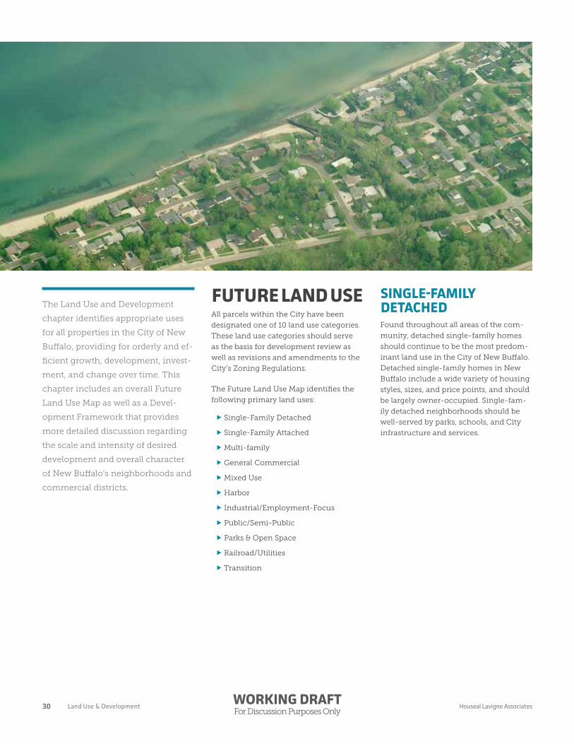
The Land Use and Development
chapter identifies appropriate uses
for all properties in the City of New
Buffalo, providing for orderly and ef-
ficient growth, development, invest-
ment, and change over time. This
chapter includes an overall Future
Land Use Map as well as a Devel-
opment Framework that provides
more detailed discussion regarding
the scale and intensity of desired
development and overall character
of New Buffalo’s neighborhoods and
commercial districts.
FUTURE LAND USEAll parcels within the City have been
designated one of 10 land use categories.
These land use categories should serve
as the basis for development review as
well as revisions and amendments to the
City’s Zoning Regulations.
The Future Land Use Map identifies the
following primary land uses:
f Single-Family Detached
f Single-Family Attached
fMulti-family
f General Commercial
fMixed Use
fHarbor
f Industrial/Employment-Focus
f Public/Semi-Public
f Parks & Open Space
f Railroad/Utilities
f Transition
SINGLE-FAMILY DETACHEDFound throughout all areas of the com-
munity, detached single-family homes
should continue to be the most predom-
inant land use in the City of New Buffalo.
Detached single-family homes in New
Buffalo include a wide variety of housing
styles, sizes, and price points, and should
be largely owner-occupied. Single-fam-
ily detached neighborhoods should be
well-served by parks, schools, and City
infrastructure and services.
30 Land Use & DevelopmentWORKING DRAFTFor Discussion Purposes Only
Houseal Lavigne Associates

SINGLE-FAMILY ATTACHEDAttached single-family homes con-
sist of structures containing multiple
single-family dwellings, each sharing a
common wall with at least one adjacent
dwelling, and with each unit having
direct access to outside. Within New Buf-
falo, row homes are the most common
type of single-family attached housing.
Residential developments within and
surrounding the marina area also primar-
ily comprise of single-family attached
housing. The intensity and character
of single-family attached units should
be compatible with surrounding sin-
gle-family neighborhoods. More intense
single-family attached development is
appropriate within and in areas adjacent
the downtown, or strategically located to
serve as a buffer between single family
neighborhoods and areas of more intense
development including the Red Arrow
Highway and Whittaker Street corridors.
MULTI-FAMILYThe multi-family land use consists of
structures with multiple housing units
that utilize common entrances, hallways,
and shared building amenities. Examples
of multi-family residential developments
include apartments, condominiums, and
senior housing. Multi-family develop-
ment is currently limited to properties
along the marina and is typically three-
to four-stories in height. Moving forward,
additional multi-family development
should be encouraged in and around
Downtown New Buffalo.
GENERAL COMMERCIALCommercial uses provide for the day-
to-day retail and service needs of New
Buffalo’s residents as well as the needs of
visitors and those passing through the
community. General commercial uses
include a range of uses such as restau-
rants, retail shops, entertainment venues,
offices, grocery stores, service uses,
and more. The Red Arrow Highway and
Whittaker South Street corridors should
continue to anchor New Buffalo’s general
commercial development, accommodat-
ing auto-oriented, yet pedestrian-friendly
development that provides as wide range
of goods and services.
MIXED-USEMixed-use development, most typically
found in Downtown, is characterized
by two- to four-story buildings with
restaurant, retail, and service uses on
the ground floor, and office or residen-
tial uses on the upper floors. Mixed-use
buildings should be located at or near the
sidewalk with parking located at the rear
of the building. Mixed-use development
should be encouraged within the Down-
town, but can also be incorporated within
New Buffalo’s other general commercial
areas where appropriate.
HARBORThis category comprises uses related to
the function and operation of the New
Buffalo Harbor. The harbor use includes
private marinas, boat slips and docks, and
yacht clubs, as well as the City Transient
Marina and City Boat Launch. Devel-
opment and reinvestment in this area
should strive to leverage the waterfront
area as a community amenity by im-
proving public access to the waterfront,
maintaining views of the water and
horizon, and encouraging development
that “pulls” the lakefront and water areas
inland, rather than simply walling off the
waterfront and blocking if from more
inland parts of the community.
31Land Use & DevelopmentWORKING DRAFTFor Discussion Purposes Only
Houseal Lavigne Associates

INDUSTRIAL/EMPLOYMENT-FOCUSThough limited in scale currently, future
industrial and other employment-fo-
cused development are desirable to
broaden and better establish more year-
round economic activity in New Buffalo.
This category can includes a range of
uses that provide year-round employ-
ment such as such as research and
development, light manufacturing and
assembly, commercial service and con-
tracting, office, and more. To minimize
conflicts with established residential
neighborhoods and commercial areas,
future industrial/employment-focus
land uses should be located south of the
railroad corridor. Buffering and screen-
ing regulations should also be in place to
appropriately mitigate potential negative
impacts.
TRANSITIONThis large are is primarily wooded and
undeveloped, but represents a signifi-
cant opportunity for new development.
Although it represents a large tract of
natural area that could be preserved as
open space, it could also be designated to
transition to an industrial/business park
development area. Given the right de-
velopment and user, the large area could
provide a great opportunity for a sizable
employment use or attractive business
park campus setting. The wooded nature
of the site could be incorporated into any
development to ensure screening and
buffering from adjacent areas.
PUBLIC/SEMI-PUBLICThe public/semi-public land use com-
prises institutions and community
facilities that contribute to New Buffalo’s
overall quality of life and local culture.
This use category includes both public
facilities, such as the library, schools, and
the City Hall, as well as private facilities
such as religious institutions. Public/
semi-public uses can be found through-
out the community, but they are general-
ly located proximate to residential areas.
Public/Semi-public land uses and related
policies are discussed in more detail in
Chapter 6: Community Facilities.
PARKS/OPEN SPACEThe parks/open space land use catego-
ry includes parks, open spaces, natural
areas, and important natural features
such as the Lake and lakefront area,
wooded areas, wetlands, streams, and
rivers. These areas can be either public or
private. The components of the parks and
open space category and other relevant
information are further explained and
detailed in Chapter 7: Parks, Open Space,
and Environmental Features Plan.
RAILROAD/UTILITIESUtilities and railroad rights-of-way and
facilities, passenger station, parking ar-
eas, maintenance facilities and grounds,
and more, collectively provide critical
infrastructure throughout the communi-
ty for the transporting of freight and pas-
sengers. Utilities and rail are discussed in
more detail in Chapter 5: Transportation
Plan and Chapter 6: Community Facili-
ties.
32 Land Use & DevelopmentWORKING DRAFTFor Discussion Purposes Only
Houseal Lavigne Associates

CITYBEACH
THE HARBOR
LAKE MIC
HIGAN
ROSE
CIT
Y
EAGLE
WATER
DETROIT
MERCHANT
BARKER
MICHIGAN
TOWNSEND
BARTON
JAMESON
FRANKLIN
NORTON
MAYHEW
JEFFERSON
OSELKA
SHORE
BRONSON
NORTH
BERRIENM
ARSHALL
BIDDLE
CHICAGO
GRIFFITH
WATER
INDIANA
WILSON
TAYLOR
WASHINGTON
BERRIEN
HARRISONCHICAGO
BUFFALO
WHITTAKER
HARBOR COUNTRY
MECHANIC
WILLARD
CLAY
STROMER
MADISON
BELL
BUFFALO
MARQUETTE
12
12
12
239
94
Single-Family Detached
Single-Family Attached
Multi-Family
Mixed Use
Commercial General
Harbor
Industrial / Employment-Focus
Public / Semi-Public
Parks / Open Space
Beach
Railroad / Utilities
Transition
Key
FUTURELAND USE
33Land Use & DevelopmentWORKING DRAFTFor Discussion Purposes Only
Houseal Lavigne Associates

DEVELOPMENT FRAMEWORKThe New Buffalo community prides itself
on the quality of its neighborhoods, the
charm of its Downtown, and its reputa-
tion as a desirable waterfront destination
for sun, fun, and family. The Develop-
ment Framework provides guidance
on key issues impacting New Buffalo’s
residential and commercial areas. The
primary goal of the Development Frame-
work is to preserve and enhance the es-
tablished and desirable character of New
Buffalo’s neighborhoods while diversi-
fying housing options, expanding the
Downtown and lakefront, and strength-
ening the year-round economy.
The Development Framework divides the
Downtown into nine areas:
f Inland Neighborhood (pg 36)
f Core Neighborhood (pg 38)
fOpen Space/Residential (pg 39)
f Downtown New Buffalo (pg 40)
fHarbor/Lakefront (pg 44)
f Red Arrow Highway (pg 46)
f South Whittaker Corridor (pg 48)
f South Whittaker Business Park (pg 50)
f Preserve/Transition (pg 51)
34 Land Use & DevelopmentWORKING DRAFTFor Discussion Purposes Only
Houseal Lavigne Associates

THE HARBOR
CITYBEACH
LAKE MIC
HIGAN
ROSE
CIT
Y
EAGLE
WATER
DETROIT
MERCHANT
BARKER
MICHIGAN
TOWNSEND
BARTON
JAMESON
FRANKLIN
NORTON
MAYHEW
JEFFERSON
OSELKA
SHORE
BRONSON
NORTH
BERRIENM
ARSHALL
BIDDLE
CHICAGO
GRIFFITH
WATER
INDIANA
WILSON
TAYLOR
WASHINGTON
BERRIEN
HARRISONCHICAGO
BUFFALO
WHITTAKER
HARBOR COUNTRY
MECHANIC
WILLARD
CLAY
STROMER
MADISON
BELL
BUFFALO
MARQUETTE
12
12
12
239
94
Core Neighborhood
Inland Neighborhood
Open Space / Residential
Downtown
Red Arrow Highway
Harbor / Lakefront
S. Whittaker Corridor
S. Whittaker Business Park
Preserve / Transition
Key
DEVELOPMENTFRAMEWORK
35Land Use & DevelopmentWORKING DRAFTFor Discussion Purposes Only
Houseal Lavigne Associates

INLAND NEIGHBORHOODThe Inland Neighborhood area consists of
the residential neighborhoods south of Red
Arrow Highway. This area is available to res-
idents at various stages of life from young
professionals and families to empty-nesters
and seniors. This area also provides a wider
range of neighborhood character than other
areas of the City, ranging from lower density
areas with larger lots and somewhat rural
character, to more traditional neighborhood
development and even some single-family
attached and medium-density residential
areas. This area of the City is also home to
the community’s public school campus
(elementary, middle, and high school) and
various parks sites.
This area of the City is crucial in meeting
the housing needs for current and future
resident populations. The area provides a
stable single-family residential character,
yet provides opportunity for a variety of
new infill development including addition-
al single-family detached, attached, and
multi-family residential, including senior
housing.
In addition, because this residential area is
slightly further away from the Downtown
and lakefront areas, it is less impacted by
the demand for vacation property conver-
sions, thus helping to keep the area more
affordable. Proximity to public schools also
increased The desirability of the neigh-
borhood for families with school-aged
children.
Key objectives:
f Establish property maintenance sup-
port programs
f Provide opportunities for affordable
housing
f Provide a mix of dwelling unit types
f Encourage new development and
investment
f Prioritize code enforcement
f Repair sidewalks and complete con-
nected network
f Repair streets and install curb and
gutter
Focus on InfillThere are several residential blocks with-
in the Inland Neighborhood that have
numerous vacant lots and opportunities
for new investment with minimal barri-
ers. Infill development and the redevelop-
ment of vacant residential parcels should
be prioritized. While amendments to de-
velopment regulations and the marketing
of residential development opportunities
may foster increased development within
less occupied areas of the community,
measures should be taken to facilitate
new development that is of high quality
and reflective of the character of nearby
homes that have already been built.
36 Land Use & DevelopmentWORKING DRAFTFor Discussion Purposes Only
Houseal Lavigne Associates

Opportunity for VarietyWith its larger parcels, number of vacant
lots, and greater affordability relative to
areas closer to the lake, the Inland Neigh-
borhood provides increased opportuni-
ties for a greater variety of housing and
development types. While the area should
remain a predominantly single-family
detached neighborhood, The City should
work with local developers and build-
ers to explore and realize opportunities
for new single-family attached and
multi-family residential development.
Any non-single family detached resi-
dential development should ideally be
located near the edge corridors of Red
Arrow Highway, Whittaker Street, and the
CSX railroad corridor, providing a transi-
tional use between areas of more intense
commercial activity and the established
single-family residential areas. Any new
development should be sensitive to and
compatible with the single-family char-
acter of the neighborhood.
Property MaintenanceWhile New Buffalo’s neighborhoods
remain healthy and stable overall, the
Village has not been immune to the
issues of foreclosures and poor property
maintenance that were exacerbated by
the recent (2008) recession. These issues
are symptomatic of regional and national
housing market trends, and by no means
unique to New Buffalo, but the City can
play a role in improving housing condi-
tions within its neighborhoods.
The City should work with the commu-
nity, including Berrien County and local
financial institutions, to identify funds
and establish maintenance assistance
programs designed to aid homeowners
and landlords in improving the condition
of their properties. The intent of such a
program would not be to subsidize rou-
tine maintenance, but provide assistance
with improvements that support com-
munity-wide goals.
Code EnforcementThe enforcement of the City building
code and property maintenance related
ordinances is crucial in maintaining a
quality environment for residents and
businesses throughout New Buffalo. The
City should continue to budget for and
support staff in undertaking consistent
and effective code enforcement through-
out the community. The City should
also establish a process through which
concerned residents and neighbor-
hood groups can assist with monitoring
their own neighborhoods and limit the
impacts of poor property maintenance.
Such a process should include code
enforcement education to familiarize
residents with City ordinances.
37Land Use & DevelopmentWORKING DRAFTFor Discussion Purposes Only
Houseal Lavigne Associates

CORE NEIGHBORHOODThe Core Neighborhood area consists
primarily of the residential neighbor-
hoods north of Red Arrow Highway and
south of the Amtrak railroad line, and
the residential neighborhood west of the
harbor between the Amtrak line and Lake
Michigan. This area is primarily sin-
gle-family detached residential, but also
contains some single-family attached
and multi-family development. The area
is also a mix of permanent/year round
residences and summer/seasonally oc-
cupied units. The neighborhood consists
of several blocks of fairly uniform lot
sizes and patterns, with greater lot size
and pattern variety nearer the lake. The
neighborhood is also home to some
public facilities (water plant, churches,
school) and limited open space.
Proximity of this neighborhood to the
Downtown and lakefront make it a pri-
mary location for seasonal residences,
with increased activity, pedestrian traffic,
and residential occupancy during the
summer months. As important as the
character of Downtown New Buffalo, the
upkeep, appearance, investment, and
pedestrian-friendliness of this neigh-
borhood is an essential component of
strengthening the City’s reputation and
sense of place for both full-time and part-
time residents, and visitors. This neigh-
borhood area is unique in that it has di-
rect significance on both the commercial
and residential offerings of the City.
Key Objectives:
f Complete the sidewalk network
fMaintain single-family detached
character
f Prioritize code enforcement
f Repair streets and install curb and
gutter
f Buffer non-residential uses
f Encourage new development and
reinvestment
ConnectivityTo the extent possible, the Core Neigh-
borhood should be physically and
visually connected to Downtown and the
lakefront. Pedestrian and bicycle mobility
and environment are a priority, with a
complete network of well maintained and
connected sidewalks on all sides of all
blocks. Bicycle lanes and facilities should
be installed and designated to the extent
appropriate and practical.
Non Single-Family Infill DevelopmentAlthough some opportunity exists for
non-single-family infill development
within the neighborhood, such as town-
homes, condominiums, and apartments,
such development should only be
approved on a very limited basis, if at all.
The areas surrounding the neighborhood
along the marina and within and near
downtown, offer a wide range of higher
density multi-family and single-family
attached product, with opportunity for
even more. The established single-family
detached character of the Core Neighbor-
hood should be protected and enhanced,
not eroded. If new non-single-family
residential development is considered, it
should be of the type intended to provide
permanent/year round housing for City
residents, possibly including senior
housing.
38 Land Use & DevelopmentWORKING DRAFTFor Discussion Purposes Only
Houseal Lavigne Associates

CharacterThe character of the residential neigh-
borhoods surrounding a downtown is
one of the most significantly contributing
components to the character and per-
ception of the downtown. Understanding
this fact underscores the importance of
maintaining an attractive, charming,
and desirable residential environment
throughout the neighborhood. Any suc-
cessful Downtown requires a residential
component along with the mix of com-
mercial and recreational offerings, and
this neighborhood is part of the down-
town’s residential make-up. Property
maintenance and code enforcement are
essential, as are development regulations
and guidelines to ensure desirable high
quality residential development.
There is a rhythm to neighborhoods such
as this and new development, whether
small or large, traditional or contempo-
rary, should reinforce the establish charm
and character of the neighborhood.
Where nonresidential uses do encroach
into the neighborhood, such as the boat
storage facility at the corner of Willard
and Mechanic, special attention should
be given to screening such uses and
mitigating any negative impacts on the
neighborhood.
OPEN SPACE/RESIDENTIALThis designation represents a very
unique condition found in the area
between the Amtrak railroad tracks and
Lake Michigan, northeast of the City
Beach and Harbor. This area is home to
single-family detached residences adja-
cent to large natural open spaces such as
Lake Michigan, the City Beach, the Galien
River and Preserve. These homes are
considered “up on the dunes”, “back on
the river”, or “set in the woods”. The area
is largely characterized by the stunning
natural environment and features that
contribute so much the City’s beauty and
sense of place.
There is very little development oppor-
tunity remaining in this area (with the
exception of some sites along Preserve
Way) and the priority moving forward
should be on maintaining the beauty
and health of the natural ecosystems and
resources for the entire community, and
not just for the benefit of those who live
adjacent or in close proximity. These nat-
ural areas and features represent one-of
a kind beauty, essential natural systems
and resources, recreational amenities,
and enhanced tourism and revenue
opportunities for the City. The priority
going forward should be preserving these
natural areas and not accommodating
additional private development.
Key objectives:
f Prioritize natural features and eco-
systems
f Limit future development to mini-
mize impact
f Provide access for recreation (“soft
impact”)
39Land Use & DevelopmentWORKING DRAFTFor Discussion Purposes Only
Houseal Lavigne Associates

DOWNTOWN NEW BUFFALOThe historic North Whittaker Street cor-
ridor forms the heart of Downtown New
Buffalo and the community as a whole.
As identified in the Future Land Use
Map, the City should continue to support
new development and reinvestment that
provides for a mix of uses and maintains
or establishes a streetwall along North
Whittaker Street and Red Arrow Highway.
Mixed use developments should include
a combination of retail, restaurant, en-
tertainment, and service uses, with office
and residential uses located on the upper
floors of buildings.
New development in the Downtown
should encourage walkability and pro-
mote a pedestrian-friendly environment.
Where possible, off-street parking should
be provided at the rear of buildings or
in shared lots on the edge of the district.
Additional multi-family and single-fam-
ily attached development should also be
encouraged on blocks surrounding the
downtown to foster pedestrian activity
throughout the day.
The Downtown has been studied ex-
tensively over the years and a variety
of plans have been developed, from
master plans to streetscape concepts
and design. There is now a sense of
urgency to downtown improvement as
signs of stalled development, deferred
maintenance, lack of investment, and
an eroding pedestrian environment are
becoming more significant.
Key objectives:
f Prioritize the pedestrian
fMaintain views to the Lake
f Provide additional off-street public
parking
f Enhance the streetscape and appear-
ance
f Provide additional gathering places/
plazas
f Encourage new high quality devel-
opment
f Improve connectivity between the
Downtown and lakefront/beach areas
f Construct a new pedestrian bridge
over the river
40 Land Use & DevelopmentWORKING DRAFTFor Discussion Purposes Only
Houseal Lavigne Associates

P
CITYBEACH
LAKE MICHIGAN
12
12
Key
DOWNTOWN & LAKEFRONTFRAMEWORK
P
Downtown Gateway & Entry
Downtown Streetscape
Key Intersection
Key PedestrianIntersection & Crosswalk
Realigned Marquette Road
Redesigned Lakefront /Beach Campus
Downtown Approach Enhancements
Pedestrian Bridge
Boardwalk
Redevelopment Site
Public Parking
Potential Public Plaza
Surface Parking Lot Improvements
Maintain Lakefront View
41Land Use & DevelopmentWORKING DRAFTFor Discussion Purposes Only
Houseal Lavigne Associates

Pedestrian is PriorityThroughout the Downtown, accommo-
dating the pedestrian and creating a safe,
attractive, easily navigable, and engaging
pedestrian environment is a top priority.
Mid-block curb cuts should be eliminated
where possible and drive-through facili-
ties should be prohibited. From Red Arrow
to the lakefront, the sidewalk should be as
continuous as possible, and automobile
conflicts minimized. The sidewalk should
be as wide as possible, given parking
needs and vehicular circulation require-
ments, in order to create opportunities
for outdoor dining, sidewalk displays,
gathering areas, and the accommodation
of large volumes of pedestrians.
The creation of a new plaza or pedestrian
gathering areas should also be explored
in the downtown, potentially at the
intersection of Whittaker and Mechanic
or Whittaker and Merchant. All pedes-
trian crossings at every Whittaker Street
intersection should be improved and
enhanced to reinforce the pedestrian
environment. For every land use and
development decision in the Downtown,
the City must first ask the question “Will
this proposed development or project
improve the pedestrian environment of
the Downtown and will it improve the
pedestrian experience?” If the answer is
no, the proposed development or project
should not be undertaken.
Parking is EssentialWhile parking is essential for the Down-
town, it should not be a dominant land
use in the core Downtown area. In terms
of Land use and development, surface
parking lots should be located at the rear
of buildings or at off site locations away
from Whittaker Street. Ideally, surface
parking lots should not exist along Whit-
taker Street. On street parking should
be maximized throughout Downtown
and new public lots should be created.
Construction of a new public parking lot
should be considered between Mechanic
Street and the Amtrak railroad tracks, east
of Thompson Street. This location is ide-
ally situated to accommodate parking for
both Downtown and City Beach/lakefront
visitors. Any new parking lot should be
located so as to minimize impact on the
surrounding residential neighborhoods.
42 Land Use & DevelopmentWORKING DRAFTFor Discussion Purposes Only
Houseal Lavigne Associates

Lake/Downtown ConnectivityThe connection between the Downtown
and the beach/lakefront should be as
strong as possible – visually, physically,
and functionally. A new pedestrian bridge
should be installed just south of the exist-
ing Whittaker Street bridge to seamlessly
tie together the Downtown and lakefront.
In addition, line-of-site from all public
rights-of-way (primarily Whitaker Street)
and gathering areas in the Downtown
to the lake, horizon, dunes, and marina
should be maximized. Lake Michigan
is an important amenity for the entire
Downtown and the entire communi-
ty, and it should not be screened from
view. Maintaining this lake line-of-site is
essential. To further this end, overgrowth
of plants, trees, and shrubs should be
removed wherever possible to increase
views to the lakefront.
New DevelopmentNew development in the Downtown
is necessary to fill the gaps created by
vacant and underutilized properties and
stalled development. New development,
however, must reinforce the charm,
desired character, and unique appeal and
sense of place that New Buffalo provides.
New development along Whittaker Street
should be located at or near the sidewalk,
provide high quality material and design,
pedestrian focus and detail, first floor
facades that are inviting, attractive, and at
least 50% clear windows. The City should
utilize professional development review
services to ensure all proposed develop-
ment is appropriate and of the necessary
design and quality.
43Land Use & DevelopmentWORKING DRAFTFor Discussion Purposes Only
Houseal Lavigne Associates
HARBOR/LAKEFRONTThe Harbor/Lakefront area consists
primarily of the marina, immediately
adjacent marina-oriented residential,
lodging/hotels, marina related services
and storage facilities, the public beach,
public boat launch, parks, and related
surface parking. This area represents the
heart of much of the summertime rec-
reational activity and is the engine that
drives much of the nearby Downtown
and residential activity and investment.
The area is nearly 100% built-out, with the
exception of a handful of infill residential
parcels. Past development decisions have
virtually eliminated views to the water,
marina, and beach from areas other than
those immediately adjacent to the water’s
edge. As a result, the only view corri-
dor allowing the water to penetrate into
the visual fabric of the Downtown and
community, is a view straight down the
Whittaker Street corridor.
The area adjacent to Marquette Drive,
including the City Beach, parking lot,
public boat launch, Lions Pavilion Park,
and Riverfront Park, presents an oppor-
tunity for a completely reconfigured and
designed beach front recreation campus.
Such a redesign could/should include a
new pedestrian bridge over the Galien
River, outdoor entertainment venue,
relocated parking for beach and boat
launch, a realignment of Marquette Drive,
a boardwalk type feature along the chan-
nel, and much more. This area represents
the edge of the City, but it is front and
center in terms of priority, activity, and
importance.
Key objectives:
f Prioritize the pedestrian
f Redesign the lakefront campus (City
Beach, City Boat Launch, Riverfront
Park, Lions Park and Pavilion)
fMaintain views to the Lake
f Improve connectivity between the
Downtown and lakefront/beach areas
f Construct a new pedestrian bridge
over the river
f Explore realignment of Marquette
Drive as part of campus redesign
f Construct a new on-site City Beach/
lakefront maintenance facility
44 Land Use & DevelopmentWORKING DRAFTFor Discussion Purposes Only
Houseal Lavigne Associates

Maintain the ViewLake Michigan is one of the most
amazing natural features in the world.
It is beautiful, unique, and New Buffa-
lo’s greatest asset. And yet, views to the
water, horizon, and beachfront are all
but screened from view by development
that has occurred over the years. The City
seems to have failed to prioritize protect-
ing views to the water from points inland,
with the exception of a relatively narrow
view corridor straight down Whittaker
Street. Going forward, protecting and
creating views to the water must be a
priority, and a key determinant when
evaluating any investment in the Harbor/
Marina and Downtown areas.
Pedestrian MobilityLike in the Downtown, accommodat-
ing the pedestrian and creating a safe,
attractive, easily navigable, and engaging
pedestrian environment is a top priority.
As the activity hub for the area, and with
parking at a premium and auto traffic of-
ten congested, walking and biking are the
preferred modes of transportation. Both
public and private improvement should
focus on improving and supporting pe-
destrian mobility and creating a welcom-
ing and accommodating pedestrian envi-
ronment. To this end, a new pedestrian
bridge over the channel, connecting the
Downtown to the City Beach area, should
be a top priority.
City Beach/Waterfront CampusOver the years there have been a number
of development/improvement/concept
plans for a reconfigured beachfront area.
Currently, the area appears “tired” and
is in need of improvement. The idea
of redesigning this area and creating a
new lakefront campus is a great idea.
Although such an undertaking would re-
quire its own study and design initiative,
components to be considered include:
reconfiguring the Marquette Drive align-
ment to push Marquette further south
thereby creating a larger contiguous
campus area; “flipping” the location of
the beach parking with Lions Pavilion
Park allowing the park to be immediately
adjacent to the beach; reducing the area
devoted only to boat launch parking,
enabling potential use of boat launch
parking for general beach parking during
periods of low activity at the boat launch;
creating continuous sidewalk/boardwalk
connecting the lakefront to Downtown,
running along the channel, over the new
pedestrian bridge, and aligning with the
sidewalk on the west side of Whittaker
Street; replace the dated beach facility
building; create a new outdoor concert/
entertainment venue space; and much
more.
45Land Use & DevelopmentWORKING DRAFTFor Discussion Purposes Only
Houseal Lavigne Associates

RED ARROW HIGHWAYThe Red Arrow Highway Corridor serves
as a primary gateway to New Buffalo
from neighboring communities to the
north and south along the Lake Michi-
gan coastline. A wide range of corridor/
neighborhood scale commercial devel-
opment should be encouraged along Red
Arrow to provide local access to goods
and services, and strengthen the local
tax base and employment opportunities.
Available sites for development along the
corridor are fairly well established due to
existing block and parcel layout.
In many areas however, the lots front-
ing Red Arrow are relatively small with a
shallow depth, limiting the potential for
new development. There are however,
several vacant and underutilized sites
along the corridor that present current
development opportunity. Development
along the corridor must safely accommo-
date the automobile, pedestrian, and cy-
clist, especially in those blocks closest to
Downtown, but ideally for the full length
of the corridor (from St. Mary of the Lake
to Redamak’s).
Key objectives:
f Provide contiguous sidewalks along
both sides of Red Arrow (may require
easements)
f Establish and enforce development
standards for on-site landscaping
f Enhance corridor streetscape and
appearance of key intersections
f Implement wayfinding improvements
fMinimize and eliminate unnecessary
curb cuts
f Improve internal cross access of
adjacent sites
f Support new development on key
sites along the corridor
f Explore removing truck route desig-
nationW
ILSO
N S
T
TOW
NSE
ND
ST
THOM
PSO
N S
T
MERCHANT ST
BUFFALO ST12
Existing Building (To Remain)
Existing Parking (To Remain)
Potential Infill Development
Potential Shared Parking
Potential Consolidated Access Drives
Potential Curb Cut Removal
ILLUSTRATIVE RED ARROW REDEVELOPMENT
46 Land Use & DevelopmentWORKING DRAFTFor Discussion Purposes Only
Houseal Lavigne Associates
Access ManagementAccess management is an important issue
along all major roadways. To the extent
possible, the City should seek to minimize
the number of direct curb cuts/driveways
along Red Arrow. The City should en-
courage internal cross access of adjacent
properties and encourage property access
from intersecting side streets to reduce
the number of needed curb cuts wherever
possible along the roadway. By reducing
the number of curb cuts, safety and traffic
flow are improved, as is the potential for
more attractive sites and enhanced corri-
dor appearance as a whole, by creating less
pavement and more areas for landscaping.
Over time, as more properties are as-
sembled and/or developed, like possibly
the area between Townsend and Ramo-
na, these properties could have a single
ingress/egress that would provide joint
access to a shared parking area at the rear
of the buildings. Even if the smaller resi-
dential structures remain for commercial
uses, a shared parking area with unified
access could improve the business viability
by collectively providing more parking
than any individual site could provide on
its own. In several areas, single-family
homes have been converted to commercial
uses. While the City should continue to
allow for the commercial use of these sites,
access management must be improved to
minimize or eliminate access points along
heavily traveled Red Arrow Highway.
Corridor Appearance, Screening & BufferingCurrently, few sites along Red Arrow are
attractively landscaped. The corridor itself
is lacking any right-of-way streetscape
enhancement along its length and most
parking lots have no perimeter or internal
landscaping. In general, sites are poor-
ly landscaped and the corridor has an
overall unattractive appearance. The City
should develop landscaping and design
standards for all new development along
the corridor to ensure future development
is of a higher quality appearance that
contributes to a more attractive corridor
that helps to establish a better character
and image of New Buffalo.
These standards should include parking
lot perimeter and internal landscaping, as
well as foundation planting and other site
enhancements. Red Arrow serves as an
approach route into the community and
it is important that it be attractive and
reflective of the City’s desired charac-
ter. Additionally, new standards should
be explored for screening and buffer-
ing commercial activity and uses from
adjacent residential properties. A key
component of the Plan is to strengthen
the overall character of the residential
neighborhoods, and an important part of
such a strategy is to mitigate the extent
possible the impacts of abutting com-
mercial development.
Accommodating Cars & PeopleUnlike the Downtown, Red Arrow High-
way has to have a greater design empha-
sis on accommodating the automobile.
However, the pedestrian must still be
accommodated safely on each site and
along both sides of the corridor. In the
summer months, large groups of pedes-
trians stream from the downtown area to
destinations such as Oinks and Reda-
mak’s. Sidewalks should exist on both
sides of Red Arrow Highway, be at least
5’ wide, and maintained in good condi-
tion. At a minimum, sidewalks should
be provided along the corridor between
Kenzie Street to the east and Monroe
Street to the west. All sites, especially any
new development, must ensure the site
is designed in a manner that accommo-
dates getting pedestrians safely from the
public sidewalk and parking areas to the
primary entrances of the building and the
other gathering areas on the site.
47Land Use & DevelopmentWORKING DRAFTFor Discussion Purposes Only
Houseal Lavigne Associates

SOUTH WHITTAKER CORRIDORThe South Whittaker Street Corridor
serves as the regional gateway into
New Buffalo from I-94 and is a primary
approach route into the Downtown and
Lakefront area. Although the South Whit-
taker Corridor lacks the development in-
tensity of Red Arrow Highway, it provides
a wide range of commercial, residential,
and industrial uses. Although similar
development patterns exists along much
of its length, the corridor varies a bit in
character as it transitions south away
from Red Arrow Highway. The Red Arrow
corners, developed with a bank and the
development potential of a prominent
vacant lot, anchor the South Whittaker
Corridor, but are functionally part of the
Downtown.
The Corridor provides small unique func-
tional areas that are subtly different and
require varying approaches to accommo-
dating improvement over time. In general,
the corridor will remain a primarily com-
mercial corridor that will likely intensify in
the future, including the redevelopment
and assembly of smaller parcels into new
larger commercial properties. However,
residential conversions to business uses,
and some remaining residential uses, will
continue to be a part of the South Whittak-
er Street Corridor. At the southern end of
the corridor is the potential to build upon
the exiting light industrial uses to create a
larger light industrial/commercial-service
employment area.
Key objectives:
f Install curb and gutter
f Prioritize redevelopment of key sites
f Focus on development and enhance-
ment of key “nodes”
f Provide contiguous sidewalks and
curb-separated bike lanes (cycle
tracks)
f Install gateway/entry features
f Install streetscape enhancements and
wayfinding signage
fMaximize development and adaptive
reuse potential of Madison & Whittak-
er site
fMaintain appearance of transition
areas
Transition Areas Between NodesThe areas along the corridor between
the nodes should continue to support
the conversion and adaptive reuse of
residential and institutional structures. In
addition, existing commercial uses and
new commercial development will locate
along the corridor as market accommo-
dates and development opportunities and
sites become available. This is the nature
of much of the corridor and it helps to
establish its character and relatively low
intensity of uses. Any new development or
intensification of existing sites and build-
ing must be respectful of and sensitive to
the immediately adjacent residential areas.
48 Land Use & DevelopmentWORKING DRAFTFor Discussion Purposes Only
Houseal Lavigne Associates

Nodal ApproachSometimes it is difficult to undertake cor-
ridor-wide development initiatives when
lack of resources and market momentum
dilute effectiveness. For South Whittaker, a
nodal approach may be a better approach
to development and land use strategies. For
example, moving southward to Clay Street
from Red Arrow, the corridor is comprised
primarily of residential and institutional
structures converted and adapted for com-
mercial use, with some exceptions. How-
ever, when you get to the area between
Clay and the railroad tracks, the character
changes and the area consists of commer-
cial uses in commercial buildings on both
sides of the street. This small, one-block
node can be improved with better signage,
streetscaping, sidewalk on the east side,
pedestrian amenities, and more to begin to
establish a quaint small commercial shop-
ping and service node.
At this location the 90° parking along the
street adds to the pedestrian environ-
ment and mix of storefronts, adding to
the unique character of this block. The
City should focus on improving this node.
By focusing on these nodes 1) Red Arrow
Highway/Whittaker node, 2) the Clay Street
node, and 3) the Madison Street node, the
corridor will begin to develop identifiable
and relatable nodes that will ultimately work
together to create the character of South
Whittaker, with smaller scaled and typically
less intense development between nodes.
Madison & Whittaker Opportunity SiteThe large property at the corner of Mad-
ison Street and S. Whittaker Street (530
S. Whittaker Street) represents a tremen-
dous opportunity for new development
and adaptive reuse. A commercial site of
this size is a scarce commodity in New
Buffalo and could accommodate a wide
range of commercial, retail, entertain-
ment, restaurant, recreation, multi-family
residential and/or mixed-use develop-
ment. The existing building is unique,
and while adaptive reuse may be chal-
lenging, it could result in a true one-of-
a-kind destination within the community
and region. A combination of adaptive
reuse of the existing structure and new
development on the balance of the site
would likely be the most market viable
solution for the property. Rather than
adhering strictly to a commercial only
scenario, the City should remain flexible
in its approach to the site and consider
a range of uses, ensuring however that
any development is compatible with
surrounding uses and helps to establish
the desired character of the community
along this important gateway.
Sidewalk Continuity & BikabilityAs along other major corridors in the
City, there should be continuous side-
walks along both sides of South Whittaker
Street, from Red Arrow Highway out to
the southern limits of the City and be-
yond. Some of the corridor has sidewalks
in good shape, some existing sidewalks
are in poor condition, and some areas
of the corridor at the southern end are
lacking sidewalks all together, along the
frontage on the east side of the road and
on both sides of the road south of the
tracks. The biggest hurdle to sidewalk
continuity is adjacent to pull-in parking
areas in front of commercial buildings,
although this is easily rectified. Addi-
tionally, sidewalks should be extended
to the areas south of the railroad tracks
as new development or uses are brought
on line. Also, on-street bike lanes should
be striped if possible, or at a minimum,
signage should be installed identifying
the corridor as an on-street bike route.
Further, if there is adequate right-of-way,
bike lanes should be physically separated
from vehicular traffic. This type of bicycle
facility is known as a curb-separated bike
lane or cycle track.
49Land Use & DevelopmentWORKING DRAFTFor Discussion Purposes Only
Houseal Lavigne Associates

SOUTH WHITTAKER BUSINESS PARKTo the south of the existing residential on
the corner of Whittaker Street and Madi-
son Street is an existing industrial/busi-
ness are that should be further developed,
improved, and expanded. If expanded,
it would improve employment oppor-
tunities and broaden the tax base with
minimal impacts to existing development
or established residential neighborhoods.
The area has great proximity to I-94
access and is located strategically for
businesses needing a convenient access
to the regional interstate network. The
area can accommodate a mix of light
industrial, commercial services, and retail
uses and currently includes uses such as
auto towing and service, a concrete plant,
self-storage, retail, and restaurant uses.
The area can also accommodate uses
and include outdoor storage and service
areas for material, equipment, or vehicles,
with sufficient property size and minimal
impact of adjacent properties.
Key objectives:
f Buffer non-residential uses from
adjacent neighborhoods
f Develop and enforce screening stan-
dards for outdoor storage
f Develop and enforce new develop-
ment standards for on-site landscap-
ing and signage
f Improve the overall appearance of the
area as a gateway
f Explore opportunities to expand the
industrial use area
Serving as an Attractive GatewayAlthough the current mix of uses and the
planned future land use for the area isn’t
necessarily the most attractive in terms
of development type, the area must still
be improved and developed over time
as attractive gateway into the commu-
nity. Commercial retail and service uses
should front Whittaker Street, with more
intense industrial uses and activities set
back a distance and screened from public
rights of way. Attractive signage, man-
icured and landscaped front yards, and
outdoor storage that is screened, should
all be characteristics of this area moving
forward.
50 Land Use & DevelopmentWORKING DRAFTFor Discussion Purposes Only
Houseal Lavigne Associates

Buffered from ResidentialAlthough the area is designated as an
industrial/business area, it is important
that any development, use, or activity be
effectively screened and buffered from
the adjacent residential areas. Outdoor
storage should not be visible from adja-
cent residential properties and perfor-
mance standards should be put into place
to safeguard against inappropriate hours
of operation, noise, vibration, air pollu-
tion, and other nuisances often associat-
ed with such activities.
Annexation and GrowthAs needed to accommodate new busi-
ness development for the area, annex-
ation of the City should be considered to
allow the industrial/business/employ-
ment area to grow. In addition to regional
transportation access and conducive
zoning, such districts need the room
to grow as such uses typically desire to
locate next to like uses. The area south of
what is currently developed is vacant and
could potential accommodate signifi-
cant growth and development, possibly
including very large employment uses.
PRESERVE/TRANSITIONThe portion of the City located west of
Whittaker Street and south of the CSX
railroad tracks is currently home to ex-
tensive woodlands and two isolated light
industrial uses. With significant opportu-
nity for infill development and reinvest-
ment within the core of the community
to the north, this area should be protected
from premature development.
However, if infill sites are unable to ac-
commodate a highly desirable develop-
ment and an opportunity is presented to
the City for such a development in this
area, then such a development should be
considered. Such a development could
range from business park and employ-
ment uses to a specialized residential
development such as senior housing
or continuing care facility. If the area is
developed, great care should be under-
taken to maximize tree preservation and
incorporate conservation design best
practices.
Key objectives:
f Insist on conservation design best
practices for new development
f Stay open to a range of potential uses/
development (from residential for
business park)
51Land Use & DevelopmentWORKING DRAFTFor Discussion Purposes Only
Houseal Lavigne Associates

WORKING DRAFTFor Discussion Purposes Only

TRANSPORTATION &MOBILITY
WORKING DRAFTFor Discussion Purposes Only

A balanced, efficient, and well-con-
nected transportation system pro-
vides access to goods, services and
community resources, and supports
land use development through a
variety of modes. The transportation
system in the City of New Buffalo
consists of an integrated network of
roadways, waterways, and an estab-
lished and developing network of
bicycle and pedestrian facilities.
The Transportation and Mobility chapter
focuses on strategic improvements to the
transportation system that capitalize on
the City’s existing infrastructure, reduce
system inefficiencies, provide missing
linkages in the transportation network,
increase downtown parking opportuni-
ties, and expand the bicycle and pedes-
trian system to reach all of the City’s
important community and recreational
facilities.
Currently, there are no major areas of
traffic congestion in the City, with the
possible exception of the Downtown/
lakefront areas during peak summer
months and activity time. This is often
related to vehicles slowing down to
enter and exit parking areas and popu-
lar destinations. But even during these
times, traffic congestions is typically not
an issue.
FUNCTIONAL CLASSIFICATION & THOROUGHFARE TYPERoadways have two basic functions: to
provide mobility and to provide land
access. For planning and design purposes,
roadways are classified in a hierarchical
structure by function to define their role in
the transportation system and their eligibil-
ity for certain types of federal transporta-
tion funds. Four general functional clas-
sifications are used, including freeways,
arterials, collectors and local roads. Arterials
are commonly subdivided into major
(principal) and minor designations based
on location, service function and design
features (i.e., right-of-way, road capacity,
continuity within system, speed limits,
parking controls, traffic signal spacing,
etc.). Each roadway classification serves as
a collecting/distributing facility for the next
higher classification in the system.
54 Transportation & MobilityWORKING DRAFTFor Discussion Purposes Only
Houseal Lavigne Associates

The following summarizes the roadway
functional classification system serv-
ing the City of New Buffalo and further
describes these thoroughfares based on
their context and design features. The
City should maintain the classifications
of its roadway system and work with
MDOT and Berrien County to improve
the operation and multi-modal function
that these roadways should provide.
FREEWAYSFreeways provide the highest degree
of mobility, with access limited to
grade-separated interchanges to preserve
capacity for high volumes of traffic and
high travel speeds. The nearest freeway
to the New Buffalo is interstate I-94,
which is accessed from Whittaker Street
just south of the city limits. I-94 at this
location is under MDOT jurisdiction.
ARTERIALS Arterials provide a high degree of
mobility and function as the primary
travel routes through urban areas. These
roadways are continuous and serve the
broader region, connecting the freeway
system with the local system of collector
roads, as well as the major activity centers
within a community. Arterials are higher
capacity facilities that carry high volumes
of traffic and require more stringent
access controls and traffic signal spacing.
In New Buffalo, arterial roadways include
US 12/Red Arrow Highway and S. Whit-
taker Street/Harbor Country Drive.
COLLECTORS The collector system is designed to
support the arterial network. Collec-
tor roads consist of medium-capacity,
medium volume roads that have limited
continuity and serve to distribute traffic
between the higher level arterials and the
lower level local roads. Collectors provide
some direct land access but to a more
limited degree than local roads. In New
Buffalo, the collectors are maintained by
the City and are two-lane roadways, with
right-of-way widths generally ranging
from 66-80 feet. Collector roadways in
New Buffalo include N. Whittaker Street,
Clay Street, and portions of Detroit Street.
Collector Streets are under the jurisdic-
tion of the City.
LOCAL ROADS Local roads provide direct access to
private property and are accessed from
arterial and collector roads. Trip lengths
on local roads are typically short and
volumes and speeds are typically low.
All remaining roadways not designated
above are classified as local roads and
are generally two-lane roadways with a
right-of-way width of 66 feet. The local
roads are also maintained by the City.
55Transportation & MobilityWORKING DRAFTFor Discussion Purposes Only
Houseal Lavigne Associates

PEDESTRIAN MOBILITYAs stated throughout this Master Plan, the
City should prioritize pedestrian mobility.
Important in every community and often
identified as a key component of quality
of life, walkability is even more import-
ant in beachfront communities, tourist
destinations, and active downtowns. In
fact, walkability and a safe and attractive
pedestrian environment is essential. For
this Plan, two primary goals drive the
need for enhanced pedestrian con-
nectivity: 1) providing the best possible
pedestrian environment for the lakefront,
Downtown, and core neighborhoods;
and 2) safe routes to schools. These two
community priorities should dictate the
investment into enhanced and thor-
oughly connected sidewalk system in key
areas of the City.
Downtown/Lakefront/Core
Neighborhoods – These areas are the
heart and soul of the New Buffalo Com-
munity. This core area is a key tourist
destination, the primary driver of the
local economy, and a defining compo-
nent of the community’s overall identity
and character.
In these areas the sidewalk network
should include a fully connected side-
walk network of 5’ wide sidewalks mini-
mum on both sides of all streets. In some
locations where right-of-way widths are
insufficient, the City should consider ac-
cess easements on adjacent properties as
necessary to install the sidewalk system.
Sidewalks on N. Whittaker Street should
be widened to the extent possible (16”+)
and a new pedestrian bridge should be
installed just south of the existing vehic-
ular bridge, seamlessly connecting the
Downtown and lakefront areas.
Safe Routes to School – For the neigh-
borhoods south of Red Arrow Highway
where a complete sidewalk system may
not be possible or desirable, the priority
should be establishing a sidewalk system
that prioritizes Safe Routes to Schools. By
identifying these routes, designating them
for sidewalks, and constructing the side-
walk network, the City will be providing
the safety and convenience necessary to
appropriately service its residents.
Intersection Improvements/Pedes-
trian Crosswalks – Throughout the
community, key intersections should be
significantly improved to provide safer
pedestrian crossing and to improve the
appearance of the corridors and commu-
nity as a whole. For prominent pedestri-
an crossing in an established pedestrian
environment, such as those along N.
Whittaker Street, intersections should
be improved with bump outs, pedestri-
an holding areas, bollard lighting, brick
paver treatments, pedestrian furniture,
signage, and more. It should be very clear
at these locations that pedestrians are
the priority and automobile must yield to
those who are walking. Even in areas that
are not established pedestrian environ-
ments, like along Red Arrow Highway
and S. Whittaker Street, improved pedes-
trian crosswalks are essential and should
be installed, especially at intersections on
Safe Routes to School designated streets.
The City should undertake any action
that can improve pedestrian safety and
strengthen the pedestrian environment.
56 Transportation & MobilityWORKING DRAFTFor Discussion Purposes Only
Houseal Lavigne Associates

BICYCLE MOBILITY & TRAILSWith relatively narrow rights-of-way
(typically 66” for most streets) throughout
the City, there is often insufficient room
to accommodate on-street bike lanes.
However, through appropriate signage,
bike route designation, on street mark-
ings, wayfinding, and a good distribution
of well placed bicycle racks and facilities,
New Buffalo can improve its standing as
a bicycle friendly community. In order
to keep bicycles off of the sidewalks,
where they don’t belong, cyclists need
to have a safe riding environment in the
street. And once the cyclists reach their
destinations, bicycle racks should be
available to accommodate their parking
needs without requiring the rider lock the
bike to a sign, light pole, or tree along the
sidewalk.
LOCAL & REGIONAL TRAILS & ROUTESFortunately, the City is well positioned to
benefit from and support regional efforts
to introduce pedestrian and bicycle trails
and routes. The Harbor Country Hike
and Bike Plan, prepared by the Friends
of Harbor Country Trails, demonstrates
a regional dedication to non-motor-
ized mobility, with the goal of providing
routes that connect municipalities from
Indiana to Warren Dunes. New Buffalo
City Beach, New Buffalo Elementa-
ry, and Oselka Park/New Buffalo High
School and Middle School are prioritized
destinations along these routes, placing
New Buffalo at the center of the regional
systems southern extent.
Four regional bicycle routes currently run
through New Buffalo:
f A route connecting New Buffalo,
Union Pier, and Three Oaks with seg-
ments along Maudlin Road, Jefferson
Road, Whittaker Street, and Marquette
Drive
f A route connecting New Buffalo,
Union Pier, Lakeside, Herbert, and
Three Oaks with segments along
Maudlin Road, Jefferson Road, Whit-
taker Street, and Marquette Drive
f A loop route that runs through New
Buffalo with an extension connecting
to Three Oaks, with segments along
Maudlin Road, Jefferson Road, Madi-
son Street, and Stromer Road
fUS Bike Route 35, which acts as a
recommended best route for cyclists
riding along the Lake Michigan Coast,
with segments along Lubke Road,
Detroit Street, Eagle Street, Clay Street,
and Red Arrow Highway
These routes feature on-street, shared
roadway configurations with signage
indicating the specified route. While they
support bicycle mobility, Whittaker Street
southeast of Red Arrow Highway is the
only segment within New Buffalo with
dedicated on-street bicycle lanes, and
Maudlin Road and Jefferson Road feature
five foot shoulders. The City should work
with the County to introduce dedicated
bicycle lanes or off-street pathways along
existing bicycle routes to improve safety
and encourage bicycle mobility.
57Transportation & MobilityWORKING DRAFTFor Discussion Purposes Only
Houseal Lavigne Associates
PLANNED TRAILSThough only a limited number of ded-
icated routes exist, the Hike and Bike
Plan identifies a number of additional
bicycle and pedestrian routes which
could benefit the City and Region. New
Buffalo is an important cross-road within
this system, connecting northern areas
of Harbor County with Three Oaks and
Indiana. Improvements within City limits
largely consist of dedicated bike lanes
and sidewalks along important routes,
with a mixture of bike lanes, shared use
paths, and shared use roads connecting
to the regional system. Roadways which
are identified for future routes and trails
have been included on the accompany-
ing pedestrian and bicycle mobility map.
The City should work with the County
and State as appropriate to make the
specified improvements along these
routes, including bike lanes, sidewalks,
and shared uses paths with proper sig-
nage. In addition, the City should make
improvements to major intersections that
will support bicycle and pedestrian safety,
such as roadway bump-outs, medians,
signage, and pedestrian signals.
Recently, through a coordinated effort
with New Buffalo Schools, St. Mary’s
by the Lake, and Friends of Harbor
Country Trails, New Buffalo received a
“Safe Routes to Schools” grant for new
sidewalks along dedicated routes. These
funds will see the beginning of imple-
mentation of the Hike and Bike Plan,
including 3.5 miles of new sidewalks to
be completed.
Roadways which will see new sidewalk
additions include:
f Bronson Street
f Indiana Street
f Detroit Street
f Clinton Street
fMarshall Street
fMonroe Street
f Eagle Street
f Chicago Street
f Berrien Street
fWillard Street
fMechanic Street
In addition to other planned improve-
ments, the Friends of Harbor Country are
currently working with the City to de-
velop a 2 mile dedicated pathway which
would connect New Buffalo High School
and Middle School to the new Sari Asher
Memorial Park (Dog Park).
58 Transportation & MobilityWORKING DRAFTFor Discussion Purposes Only
Houseal Lavigne Associates

THE HARBOR
LAKE MIC
HIGAN
ROSE
CIT
Y
EAGLE
WATER
DETROIT
MERCHANT
BARKER
MICHIGAN
TOWNSEND
BARTON
JAMESON
FRANKLIN
NORTON
MAYHEW
JEFFERSON
OSELKA
SHORE
BRONSON
NORTH
BERRIENM
ARSHALL
BIDDLE
CHICAGO
GRIFFITH
WATER
INDIANA
WILSON
TAYLOR
WASHINGTON
BERRIENHARRISONCHICAGO
BUFFALO
WHITTAKER
HARBOR COUNTRY
MECHANIC
WILLARD
CLAY
STROMER
MADISON
BELL
BUFFALO
MARQUETTE
12
12
12
239
94
PEDESTRIAN &BICYCLEMOBILITY
Bike Lanes & Sidewalks
Sidewalk Prioritization
Bike Lanes & Shared Use Path
Proposed Sidewalk (SRTS Grant)
Proposed Loop Trail (Friends of the Harbor County Trails)
Bike Lanes
Shared Use Path
Shared Use Road
USBR 35
Existing Schools
Trail Head
Priority Pedestrian Crossing
Water Course
St. Mary of the Lake School (private)
New Buffalo Senior High School
New Buffalo Elementary School
Key Existing Schools
1
1
2
2
3
3
59Transportation & MobilityWORKING DRAFTFor Discussion Purposes Only
Houseal Lavigne Associates

PUBLIC TRANSITPublic transit in New Buffalo is made
available through two service providers.
Amtrak provides transportation on a
regional scale, connecting New Buffalo to
adjacent communities and major cities,
including Chicago and Detroit. The station
generates daily activity, including 21,751
passengers in the 2014 fiscal year, or an
average of almost 60 passengers a day. On
a more local scale, the County operates
the Berrien Bus, a pay-per-trip bus system
that serves residents across the region.
Though the County does operate a few
fixed routes, none are located within New
Buffalo. The Berrien Bus operates on a call
service, with users booking travel 24 hours
in advanced and paying a fee based on the
distance they travel.
While transit in the New Buffalo area is lim-
ited, the County has planned for further de-
velopment of public transportation systems.
In 2009, the County completed Moving
Forward-A Plan for Public Transit In Berrien
County, which includes the following five
coordinated planning strategies:
f Establish a structure to build and sus-
tain coordination efforts
f Expand outreach to customers, hu-
man service agency staff, employers,
and others and provide simplified ac-
cess to information regarding existing
transportation options.
f Expand fixed route public transporta-
tion services
fUse current demand-response
services more efficiently to expand
capacity of current services offered to
individuals who need human service
and specialization transportation.
f Improve integration between county-
wide rural service, small dial-a-ride
services, and fixed routes.
60 Transportation & MobilityWORKING DRAFTFor Discussion Purposes Only
Houseal Lavigne Associates

DOWNTOWN/LAKEFRONT PARKINGParking in the Downtown/lakefront area
continues to be an issue during peak va-
cation season. Although the Downtown
has on-street parking along Whittaker
Street and the lakefront has parking at
City Beach, there continues to be a need
for additional peak season parking. Con-
sideration should be given to developing
a new public parking lot between E. Me-
chanic Street and the railroad tracks. This
area is ideally located in the Downtown
and has convenient proximity to the
beach and lakefront areas. The location
is easily accessible, off Whittaker Street,
and would accommodate a significant
number of parking spaces. The property
should be considered for acquisition or
transfer of development rights in order
to accommodate the development of the
parking.
Additionally, as new development comes
on line, additional development consid-
erations could be given to developers to
provide additional parking for public use,
over and above the parking required by
code. Such an approach could add to the
parking inventory of Downtown at no or
little cost to the City.
The Boat Launch parking area should
also be examined for better utilization
during non-peak boat launch times
that coincide with peak beach activi-
ty demand. The grant funding used to
develop the boat launch restricts parking
utilization, so additional study is required
to determine the best course of action
for activating this underutilized area for
shared parking purposes.
61Transportation & MobilityWORKING DRAFTFor Discussion Purposes Only
Houseal Lavigne Associates

GATEWAYS & WAYFINDINGGateways and wayfinding signage should
be installed at key locations throughout
the City. Gateways/entry features should
announce arrival into the City and a
different set of unique gateways should
announce entry into the Downtown. City
gateway features should be located along
Red Arrow Highway at either end of the
community and on S. Whittaker Street
near Madison Street. These gateways
should include attractive signage and
could include elements of landscaping,
lighting, public art, and more.
Unique Downtown gateways should be
installed along Red Arrow Highway near
Smith Street and Townsend Street, and
the intersection of Red Arrow Highway
and Whittaker Street should be improved
as a key intersection feature, tying in
Downtown streetscape elements and
on all four corners of the intersection,
including visually strong pedestrian
crossings running parallel to Red Arrow
Highway on intersecting cross streets,
including Whittaker.
Additionally, uniquely designed and
attractive wayfinding signage should
installed at key locatons throughout the
City providing direction to key destina-
tions. Wayfinding signage could offer
directional information for City Beach,
marina, Boat Launch, Downtown, public
parking, Library, schools, parks, City
Hall, bike trails, and more. Such signage
should be strategically placed to inform
visitors who are traveling by car, on foot,
or by bike. In addition, a pocket visitor
map/pamphlet could be produced to co-
incide and complement the wayfinding
signage program.
STREETSCAPE ENHANCEMENTSThe City should implement a streetscape
enhancement program for key areas of
the City. Streetscape improvements could
include decorative pavers or pavement,
lighting, signage, banners, landscaping,
pedestrian amenities, wider sidewalks,
pedestrian holding areas, street furniture,
public art and more.
Three levels of streetscape improvement
are recommended for the City: 1)Primary
– the most detailed, pedestrian-orient-
ed, and attractive streetscape treatment
should be implemented along Whittaker
Street from Red Arrow Highway to City
Beach; 2) Secondary – this streetscape
improvement should be designed for Red
Arrow Highway and include pedestrian
scaled amenities appropriate for a busy
auto-oriented corridor; and 3) Tertia-
ry – This enhancement level should be
implemented along S. Whittaker Street
and include components of the Primary
and Secondary design vernacular, but
at much less intense and programmed
manner. All three levels of streetscape
treatment should utilize similar design
elements so as to ensure a recognizable
image and identity that ties all areas of
the New Buffalo community together.
62 Transportation & MobilityWORKING DRAFTFor Discussion Purposes Only
Houseal Lavigne Associates

THE HARBOR
LAKE MIC
HIGAN
ROSE
CIT
Y
EAGLE
WATER
DETROIT
MERCHANT
BARKER
MICHIGAN
TOWNSEND
BARTON
JAMESON
FRANKLIN
NORTON
MAYHEW
JEFFERSON
OSELKA
SHORE
BRONSON
NORTH
BERRIENM
ARSHALL
BIDDLE
CHICAGO
GRIFFITH
WATER
INDIANA
WILSON
TAYLOR
WASHINGTON
BERRIEN
HARRISONCHICAGO
BUFFALO
WHITTAKER
HARBOR COUNTRY
MECHANIC
WILLARD
CLAY
STROMER
MADISON
BELL
BUFFALO
MARQUETTE
12
12
12
239
94
Primary Intersection
Secondary Intersection
Tertiary Intersection
Pedestrian Bridge
Primary Streetscape
Secondary Streetscape
Tertiary Streetscape
City Gateways
Downtown Gateways
Pedestrian Link
Key
STREETSCAPEIMPROVEMENTPLAN
63Transportation & MobilityWORKING DRAFTFor Discussion Purposes Only
Houseal Lavigne Associates

WORKING DRAFTFor Discussion Purposes Only

COMMUNITYFACILITIES
WORKING DRAFTFor Discussion Purposes Only

The City of New Buffalo is a home
rule community, governed by a city
council and city manager system.
The City has a 5 member City Coun-
cil elected at-large, with a mayor
and mayor pro tem elected annually
from among the City Council mem-
bers. The City Manager is appointed
by the City Council and carries out
the policies and actions of the City
Council including effective and effi-
cient provision of City services and
programs.
CITY OF NEW BUFFALOThe City government also includes the
following:
f City Assessor
f City Building Inspector
f City Clerk
f City Treasurer
f Fire Department
f Police Department
f Recreational Facilities Department
(Further discussed in the Parks, Rec-
reation, and Environmental Features
Chapter)
f Street Department
fWater Department
City HallNew Buffalo City Hall is the prima-
ry facility for the government of New
Buffalo, including the City Council
Chambers, primary offices of City staff,
Police Department, and Recreational
Facilities Department. Located just west
of Downtown, City Hall is an important
landmark within New Buffalo and serves
as a community gathering space.
Currently, the City Hall adequately
accommodates the administrative and
police functions of the City. However, if
a larger facility is necessary in the future,
consideration should be given to con-
verting the existing City Hall into a public
safety facility (possibly combining efforts
with neighboring law enforcement pro-
viders), with the administration/City Hall
operations relocated to a new or adaptive
re-use facility elsewhere in the City.
66 Community FacilitiesWORKING DRAFTFor Discussion Purposes Only
Houseal Lavigne Associates

Fire DepartmentThe New Buffalo Fire Department is a
“paid per call” fire rescue department,
providing fire suppression, fire preven-
tion-education, hazardous material re-
sponse, and vehicle extrication/accidents
response, amongst other resources. The
department includes both full time and
volunteer firefighters. The City should
regularly review facilities, equipment,
and services of the Fire Department to
ensure fire and emergency response
needs are adequately met, particularly
during summer months when the City
contains a larger population.
Police DepartmentThe New Buffalo Police Department is
located in City Hall and comprised of 7
full-time officers supported by part-time,
reserve, and seasonal officers. The De-
partment provides safety and emergency
response services within the community,
including coastline response/marine
patrol. The City should regularly review
facilities, equipment, and services of the
Police Department to ensure emergency
response needs are adequately met, par-
ticularly during summer months when
the City contains a larger population.
Street DepartmentThe Street Department is primarily
responsible for maintenance of public
streets using complete streets protocol,
stormwater management, and sani-
tary sewer collection. The department
facilities collects and conveys wastewater
within the City to a wastewater treatment
plant operated by the Galien River Sani-
tary District (GRSD) Sewer Authority. The
department is also responsible for vehicle
fleet and equipment maintenance, street
department facilities maintenance, and
the City’s urban forestry and decorative
street lighting programs.
The City should coordinate with the
Street Department to ensure continued
quality of the sanitary sewer collection
and stormwater management systems.
This is particularly important for storm-
water management as runoff waters
generated by development can have a
significant impact on the City’s most im-
portant environmental features such as
the Galien River and Lake Michigan. The
City should also work with the depart-
ment to conduct a full analysis of com-
plete street infrastructure and identify
necessary street and sidewalk improve-
ments, particularly around Downtown
New Buffalo.
The Street Department also operates the
City Maintenance garage, stockyard, and
salt storage dome located along Jeffer-
son Street. Currently, these facilities are
poorly marked and unscreened, despite
operations similar in nature of light
industrial uses. Given the potential for
new residential in this area, as well as the
nearby existing single-family homes, the
City should consider on-site improve-
ments. This provides an opportunity to
better organize these operations, screen
high-intensity uses, and establish a more
cohesive appearance for City facilities.
67Community FacilitiesWORKING DRAFTFor Discussion Purposes Only
Houseal Lavigne Associates

Water DepartmentThe Water Department functions as a
public utility that provides clean, safe
water to residents in the community. The
Department operates a water filtration
plant, located at the western end of Water
Street, and water distribution facilities
throughout the community, with Lake
Michigan being the local water source.
The Department has recently received
a Water Fluoridation Quality Award in
2014 and was the 2013 regional winner
of a water taste-off held by the Michigan
Section of the American Water Works
Association.
The system currently has a capacity of 2.5
million gallons per day, with an average
daily use in 2014 of 585,000 gallons. The
City should conduct regular analysis of
the system to ensure future demands
can be met; however, the capacity of the
system should be sufficient to address ex-
tended demand on the system that may
result for a larger year-round population
and residential growth.
Downtown Development AuthorityThe Downtown Development Authority
(DDA) was establish by the City Council
in 2014 with the aim of revitalizing and
supporting business and development in
Downtown New Buffalo. The DDA is able
to conduct studies and make improve-
ments within Downtown utilizing tax
increment financing and other fund-
ing sources. Given the importance of
Downtown within the community, the
City should coordinate with the DDA to
manage projects in the area, including
redevelopment and repurposing of the
lakefront area and projects along Whit-
taker Street. The DDA will play an import-
ant role in both the short- and long-term
success of improvements within the area.
NEW BUFFALO TOWNSHIPThe City of New Buffalo is contained
within the New Buffalo Township, which
has jurisdiction over all unincorporated
land within the township. The Township
also includes the villages of Grand Beach
and Michiana, and the unincorporated
community of Union Pier. The City and
Township are entirely autonomous; how-
ever, the close proximity of both results
in sharing of some services between City
and Township residents. For example,
New Buffalo Township Public Library is
located within the City of New Buffalo
and provides services to residents in both
the City and Township.
The City should continue to coordinate
with New Buffalo Township to identify
means by which community facilities
and services can be shared and strength-
ened within the area. This could include
cooperation on year-round events and
festivals that capitalize on the unique re-
sources of each jurisdiction. For example,
the more rural character of the Township
could help support fall and spring events
and activities.
68 Community FacilitiesWORKING DRAFTFor Discussion Purposes Only
Houseal Lavigne Associates

EDUCATIONPublic education in New Buffalo is pro-
vided by the New Buffalo Area Schools
District. The District includes New Buffa-
lo High School and New Buffalo Middle
School, which share a campus along
Clay Street, and New Buffalo Elementary
School, which is located directly outside
the City along Lubke Road.
The district serves children from the City
of New Buffalo, New Buffalo Township,
Grand Beach, and Michiana. Under-
standing that schools are often a primary
component of attracting new families to
a community, the City should coordinate
closely with the school district to main-
tain high quality educational programs
and facilities. In addition to New Buffalo
Area Schools, education is also provided
by St. Mary of the Lake Catholic Church,
which offers pre-kindergarten through
8th grade education.
LIBRARYLibrary services in New Buffalo are pro-
vided by New Buffalo Township Public
Library, which serves both New Buffalo
and Chikaming Townships. Between
2012 and 2014 the Library teamed with
the City to construct a new and improved
library building. The new facility is
located in Downtown New Buffalo along
Thompson Street, opening in August of
2014.
As New Buffalo aims to grow its perma-
nent, year-round economy and popula-
tion, the City should coordinate with the
Public Library to identify potential service
needs and improvements that will be
necessary to handle greater demand on
library services. While the building is ap-
pealing, the library’s parking lot is entirely
void of any landscaping and presents a
fairly unattractive appearance along Red
Arrow Highway and N. Thompson Street.
The library’s site should be enhanced
with both internal and perimeter land-
scaping, and consideration should also
be given to reconfiguring the parking lot
layout.
HEALTHCAREHealthcare services in Southwest Mich-
igan are provided by Lakeland Health-
care; however, no facilities are operated
within New Buffalo. Lakeland Healthcare
operates hospitals within St. Joseph,
Niles, and Watervliet. The closest hospital
facility for New Buffalo is St. Anthony
Health in Michigan City which also
provides healthcare options in the region.
Given the size of New Buffalo, addition-
al healthcare options are unlikely to be
necessary within the City.
69Community FacilitiesWORKING DRAFTFor Discussion Purposes Only
Houseal Lavigne Associates

OTHER COMMUNITY FACILITIES & AMENITIESThe following are additional facilities
and amenities within New Buffalo which
help to strengthen the quality of life in
the community. Many of these facilities
are further discussed in other chapters
of the Master Plan and are included in
this section given their contribution as a
community amenity.
Beachfront AreaNew Buffalo’s beachfront area provides
an important destination and space for
community gathering and interaction.
This includes the City Beach, City Boat
Launch, Riverfront Park, and Lions Park
and Pavilion. The beachfront is a major
source of tourism within New Buffalo
and helps to draw residents and visitors
to the community. While some concerns
were voiced during the community out-
reach process, the majority of residents
identified the beachfront area and its
recreational spaces as a critical asset in
the community.
Improvements to the beach and relat-
ed public spaces will help to encourage
further investment in New Buffalo,
attract new residents and visitors, and
better position New Buffalo to compete
with adjacent lakeside communities.
Going forward, the City should explore
realigning Marquette Drive, creating a
newly designed beachfront campus, and
constructing a new on-site City Beach
maintenance facility for the area.
New Buffalo HarborThe New Buffalo Harbor is an important
community amenity in the City, sup-
porting boating, fishing, and other water
recreation. The high volume of boating,
recreation, and hospitality uses generates
frequent activity and supports tourism
within New Buffalo. In addition, the
harbor creates an interesting “neighbor-
hood” of boat slips and docks, with clubs
and organizations that support social
interaction and create unique resident
networks.
Amtrak StationThe New Buffalo Amtrak Station provides
transportation to and from the City, con-
necting New Buffalo to adjacent commu-
nities and major cities, including Chicago
and Detroit. The station generates daily
activity, including 21,751 passengers
in the 2014 fiscal year, or an average of
almost 60 passengers a day.
70 Community FacilitiesWORKING DRAFTFor Discussion Purposes Only
Houseal Lavigne Associates

New Buffalo Railroad MuseumThe New Buffalo Railroad Museum is
a unique entertainment use within the
community with cultural and historic
value. Founded in 1989, the museum
documents the City’s heritage as a
railroad hub for both the Pere Marquette
and Chesapeake & Ohio railways. The
Museum features historical exhibits
and artifacts, a model train layout, and
historic train cars which visitors can tour,
including a Chessie Box Car and Troop
Pullman Sleeper Car.
The museum is located near the inter-
section of Whittaker Street and Jefferson
Street, adjacent to the still-operating
freight railroad line and a vacated fitness
facility, a potential redevelopment site
within the City. The site provides an op-
timal location for the museum; however,
the City should work with the museum
to explore potential improvements or
repositioning of the museum that would
better support both the museum and
future development on the site.
Religious InstitutionsChurches and religious institutions also
contribute to the local quality of life and
in many cases offer programs, activities,
and assistance for residents. For exam-
ple, St. Mary of the Lake also operates a
private Catholic school within the City.
Religious institutions also create spaces
for community gathering and encourage
social interaction.
Regionally Recognized EateriesThe City contains a number of regional-
ly recognized eateries that helps attract
visitors to the community and elevate the
prominence of New Buffalo, including
Redamak’s Tavern, The Stray Dog Bar &
Grill, Brewster’s Italian Café, and Oink’s
Dutch Treat Ice Cream & Yogurt, and local
favorites like Nancy’s, Rosie’s, Casey’s Bar
& Grill, just to name a few. The popularity
and reputation of these businesses, and
many others, makes them important
assets for the community which should
be preserved and strengthened within
New Buffalo.
Four Winds CasinoThough not contained within the City,
Four Winds Casino is an important assets
for the community, further supporting
tourism in the area. The Casino draws
visitors from across the region and pro-
vides an additional entertainment option
unique to New Buffalo. The City should
coordinate with both Four Winds Casino
and the Township to identify oppor-
tunities for cooperation which could
strengthen tourism and entertainment
within Southwest Michigan.
71Community FacilitiesWORKING DRAFTFor Discussion Purposes Only
Houseal Lavigne Associates

WORKING DRAFTFor Discussion Purposes Only

PARKS,RECREATION &ENVIRONMENTALFEATURES
WORKING DRAFTFor Discussion Purposes Only

For the City of New Buffalo, recre-
ation and environmental features
have had a significant impact on
how the community has developed
and continues to prosper as a tourist
destination. Parks, recreational fa-
cilities, and environmental features
like the City Beach and Lake Michi-
gan provide important recreational
amenities which draw visitors from
across the Midwest and beyond.
Supporting these facilities further
contributes to quality of life in the
community, enabling residents to
stay active and living a healthier life-
style. Recreational opportunities and
unique natural resources will have a
key role as the community works to
leverage its image as a resort town,
improve the major attractions which
draw visitors, and create a more
complete year-round economy.
In 2014, the City updated its Communi-
ty Park, Recreation, Open Space, and
Greenway Plan, which was developed in
collaboration with the Southwest Mich-
igan Planning Commission. The 2014
document provides recommendations
and strategies regarding parks, recre-
ation, and environmental features on a
more detailed level of analysis than does
this Master Plan. The City should work to
implement the various recommendations
and improvements discussed within that
2014 plan. This should include a review
of recommendations to identify action
items which align with goals and objec-
tives of the new Master Plan.
CITY PARKS & RECREATIONAL FACILITIESParks and recreational facilities in New
Buffalo are maintained by the Recre-
ational Facilities Department, with assis-
tance provided by the Parks and Recre-
ation Board, the Harbor Commission, and
the Planning Commission. The City of
New Buffalo owns and operates 9 parks
and facilities covering roughly 47.4 acres
of land. These valuable amenities provide
recreational opportunities for residents
and visitors, including both locations for
day-to-day recreation and major compo-
nents of New Buffalo’s tourism industry.
Given the importance of these resources,
the City should consistently review the
status of parks and recreational facilities
to proactively identify necessary im-
provements and projects. This should
include regular community outreach
efforts to determine needs and issues
emphasized by residents.
74 Parks, Recreation & Environmental FeaturesWORKING DRAFTFor Discussion Purposes Only
Houseal Lavigne Associates

CITY BEACHThe City Beach is one of the most
important destinations in New Buffalo,
giving the City its primary tourist attrac-
tion and establishing New Buffalo as a
resort community. The 15 acre City Beach
site includes 800 feet of Lake Michigan
beachfront, 6 acres of dunes, and 213
parking spaces as well as a variety of rec-
reational programming. As the City looks
to better position the City Beach and
connect it to Downtown New Buffalo,
improvements should focus on improv-
ing the pedestrian experience, connec-
tivity with adjacent areas, and providing
new facilities for recreation, civic gath-
erings, and events. In addition, concerns
for the amount of parking on site and
the need for overflow parking should be
addressed, potentially utilizing underuti-
lized areas of the City Boat Launch.
CITY BOAT LAUNCHThe City Boat Launch includes 8 launch
ramps and over 140 parking spots large
enough to accommodate a vehicle pull-
ing a boat trailer. The launch provides
access to the Galien River from which
boats can access Lake Michigan through
the New Buffalo Harbor. As the City looks
to improve the lakefront campus and
better connect the City Beach to Down-
town New Buffalo, the City Boat Launch
and its dedicated parking area could be
an important component of the overall
improvement and enhancement scenar-
io. While it is important to maintain the
launch itself with adequate parking and
meet the obligations of the grant used to
pay for the development of the launch, an
assessment should be completed to eval-
uate usage and analyze potential repur-
posing, sharing, and reconfiguration of
underutilized parking spaces to support
the City Beach and Lions Park facilities
during special events and periods when
beach activity is high and boat launch
activity is relatively low.
LIONS PARK & PAVILIONLions Park is a 2 acre mini-park which
includes a sheltered pavilion with picnic
tables, grills, and outdoor fireplaces.
Given its location, Lions Park is well
positioned to function as a community
gathering space for events and festivals.
This use is limited; however, by the size
of the park and poor accessibility for
pedestrians. Repurposing and reposi-
tioning of the park has been the focus of
numerous studies and projects. As the
City looks to provide a better lakefront
campus and better connect the City
Beach with Downtown New Buffalo,
Lions Park will play a key role in linking
the two areas. Improvements should
aim to better leverage Lions Park and the
Pavilion as community assets through
greater pedestrian access and a more
easily programmed recreational space. A
realigned Marquette Drive is one concept
the City should consider, providing the
opportunity for adjacency for City Beach
and Lions Park & Pavilion into a more
pedestrian friendly-lakefront campus.
75Parks, Recreation & Environmental FeaturesWORKING DRAFTFor Discussion Purposes Only
Houseal Lavigne Associates
RIVERFRONT PARKRiverfront Park is a linear mini-park
of less than 1 acre positioned between
Whittaker Street and the Federal Navi-
gation Channel of the Galien River. The
Park includes 2 fishing decks and a path
commonly used by those travelling to
the City Beach from other areas of New
Buffalo. Riverfront Park has been central
to numerous studies and projects regard-
ing the beachfront area and will be an
important element of designing a better
lakefront campus. Riverfront Park is also
instrumental in better connecting the
City Beach to Downtown New Buffalo,
serving as the landing pad and gateway/
welcome zone for pedestrian crossing
over from the Downtown to the beach.
Improvements should greatly focus on
the pedestrian experience, providing a
safe, efficient, and enjoyable pathway
between the two areas. The area’s contin-
ued use as an active recreational area is
important and will depend largely on the
City’s vision and redesign for the area.
TRANSIENT MARINAThe Transient Marina includes 33 boat
slips intended for shorter stay boat
docking and a small open space area
just east of the intersection of Whittaker
Street and Water Street. The Transient
Marina’s location between Downtown
New Buffalo and the City Beach make
it a prominent site. Improvements to
better connect Downtown and the beach
should leverage the Transient Marina as a
community destination and recreational
facility, bringing boaters directly in to the
shops, restaurants, and activities of the
Downtown.
OSELKA PARKOselka Park is a 17.5 acre community
park located directly adjacent to the New
Buffalo Area School’s campus. The park
includes sports fields, picnic areas, a
children’s playground, and a sledding hill,
providing recreational amenities for both
the schools and surrounding residential
areas. New sidewalks and designated bike
routes within the surrounding neigh-
borhood will help improve accessibility
to the park for residents throughout the
community.
TURTLE POND NATURAL AREATurtle Pond Natural Area is a 2 acre
protected forested wetland area with a
boardwalk for wildlife observation. The
natural area includes three unpaved
parking spots and a nature trail. The site
could benefit from sidewalks to im-
prove pedestrian accessibility from the
surrounding neighborhood as well as
new signage and improvements to better
mark the location and amenities of the
area.
SKATE PARKThe Skate Park is a programmed area
for skateboarding and similar recreation
directly adjacent to New Buffalo Area
School’s campus. This area is the only
recreational space in new Buffalo directly
aimed at youth and teenager activity.
Where appropriate, the City should create
additional spaces for youth activities to
support educational facilities and attract
new families to the area.
SARI ASHER MEMORIAL PARKSari Asher Memorial Park is a recently
completed 1.8 acre dog park. This park
provides a unique recreation spaced
which was specifically desired by mem-
bers of the community. The City should
continue to develop unique and inter-
esting recreational spaces to diversify
outdoor activities in New Buffalo. In
addition, the City should regularly con-
duct community outreach to determine
recreational needs and desires of New
Buffalo residents.
NEW COMMUNITY POOLOne amenity missing from the commu-
nity is a public pool. While some resi-
dential developments near the lakefront
provide private pools for owners and
guests of the development, the City
lacks a public indoor or outdoor swim-
ming pool. Such a facility would be a
tremendous asset for the City’s residents
and could provide both recreation and
fitness/health benefits. While an outdoor
seasonal facility is more cost effective
to construct, maintain, and operate, an
indoor facility would provide year round
recreation and fitness for New Buffalo’s
permanent residents. Such a facility
could possibly be undertaken as a joint
facility between the school and City.
76 Parks, Recreation & Environmental FeaturesWORKING DRAFTFor Discussion Purposes Only
Houseal Lavigne Associates
ADDITIONAL PARKS & RECREATIONAL FACILITIESIn addition to City facilities, a number of
additional parks and recreational facilities
exist which are owned and operated pri-
vately or by quasi-public organizations.
These facilities provide additional rec-
reational opportunities for residents and
visitors to New Buffalo, further support-
ing a high quality of life in the communi-
ty. The majority of these facilities support
private organizations and are closed to
the public or are commercial businesses
operated to offer recreational amenities.
Additional parks and recreational facili-
ties in New Buffalo and the surrounding
area include:
f The Nature Conservancy-Robinson
Preserve
f The Nature Conservancy-Grand
Beach Preserve
f Chikaming Preserve
f St. Mary’s School (Private school with
recreational facilities)
f Bible Baptist Church (Religious insti-
tutions with recreational facilities)
f Journey Lutheran Church (Religious
institution with recreational facilities)
f Adrenaline Fitness (Private member-
ship gym)
f Third Coast (Surf shop and sports
organization headquarters)
fOutpost Sports (Kayak and canoe sales
and rental)
f Camp Sokol (seasonal camp for tour-
ist hospitality)
fNew Buffalo Rod and Gun Club
(Sports organization)
fOak Hill Springs (Privately owned
open space)
f Schultz Park (Park operated by Sunset
Shores Homeowners Association)
fWhittaker Woods Golf Course
f Dunes Club Limited Gold Club
77Parks, Recreation & Environmental FeaturesWORKING DRAFTFor Discussion Purposes Only
Houseal Lavigne Associates
TRAILSThe City is well positioned to benefit
from and support regional efforts to
introduce pedestrian and bicycle trails
and routes. The Harbor Country Hike
and Bike Plan, prepared by the Friends
of Harbor Country Trails, demonstrates
a regional dedication to non-motor-
ized mobility, with the goal of providing
routes that connect municipalities from
Indiana to Warren Dunes. New Buffalo
City Beach, New Buffalo Elementa-
ry, and Oselka Park/New Buffalo High
School and Middle School are prioritized
destinations along these routes, placing
New Buffalo at the center of the regional
systems southern extent.
Four regional bicycle routes currently run
through New Buffalo:
f A route connecting New Buffalo,
Union Pier, and Three Oaks with seg-
ments along Maudlin Road, Jefferson
Road, Whittaker Street, and Marquette
Drive
f A route connecting New Buffalo,
Union Pier, Lakeside, Herbert, and
Three Oaks with segments along
Maudlin Road, Jefferson Road, Whit-
taker Street, and Marquette Drive
f A loop route that runs through New
Buffalo with an extension connecting
to Three Oaks, with segments along
Maudlin Road, Jefferson Road, Madi-
son Street, and Stromer Road
fUS Bike Route 35, which acts as a
recommended best route for cyclists
riding along the Lake Michigan Coast,
with segments along Lubke Road,
Detroit Street, Eagle Street, Clay Street,
and Red Arrow Highway
These routes feature on-street, shared
roadway configurations with signage
indicating the specified route. While they
support bicycle mobility, Whittaker Street
southeast of Red Arrow Highway is the
only segment within New Buffalo with
dedicated on-street bicycle lanes, and
Maudlin Road and Jefferson Road feature
five foot shoulders. The City should work
with the County to introduce dedicated
bicycle lanes or off-street pathways along
existing bicycle routes to improve safety
and encourage bicycle mobility.
PLANNED TRAILSThough only a limited number of ded-
icated routes exist, the Hike and Bike
Plan identifies a number of additional
bicycle and pedestrian routes which
could benefit the City and Region. New
Buffalo is an important cross-road within
this system, connecting northern areas
of Harbor County with Three Oaks and
Indiana. Improvements within City limits
largely consist of dedicated bike lanes
and sidewalks along important routes,
with a mixture of bike lanes, shared use
paths, and shared use roads connecting
to the regional system. Roadways which
are identified for future routes and trails
have been included on the Pedestrian
and Bicycle Mobility Map on page 59.
The City should work with the County
and State as appropriate to make the
specified improvements along these
routes, including bike lanes, sidewalks,
and shared uses paths with proper sig-
nage. In addition, the City should make
improvements to major intersections that
will support bicycle and pedestrian safety,
such as roadway bump-outs, medians,
signage, and pedestrian signals.
In addition to other prioritized routes, the
Friends of Harbor Country are currently
working with the City to develop a 2 mile
dedicated pathway which would connect
New Buffalo High School and Middle
School to the new Sari Asher Memorial
Park (Dog Park).
78 Parks, Recreation & Environmental FeaturesWORKING DRAFTFor Discussion Purposes Only
Houseal Lavigne Associates

ENVIRONMENTAL FEATURESThe landscape of New Buffalo inhabits
a unique place in the regional envi-
ronment. As one moves through the
community forested areas give way
to marshes and wetlands, dunes and
beaches, and finally Lake Michigan. The
environmental features of New Buffalo
are a defining element of the community
which have shaped the history of the City
and continue to impact development,
industry, and recreation. These resources
include New Buffalo’s primary tourist
attractions which have helped build the
community’s identity as a resort destina-
tion. As the City looks to better leverage
these assets, protection and preservation
of environmental features will be pivotal
to the community’s continued prosper-
ity. Further, the City should explore the
potential to further capitalize on these
and other natural resources outside of the
summer vacation months, supporting a
year-round economy.
LAKE MICHIGANLake Michigan is the most prominent en-
vironmental feature for the City of New
Buffalo. The Lake has had a significant
impact on New Buffalo as far back as the
City’s founding and continues to support
tourism, business, and growth in the
community. New Buffalo’s prominence
as a resort community has developed as a
result of the beaches, dunes, swimming,
fishing, and recreation opportunities
offered by the Lake. As a significant
element of New Buffalo, the City should
continue to be proactive in protection of
Lake Michigan and the related beachfront
and dunes. Development along the coast
should require strict adherence to Low
Impact Design (LID) and Best Manage-
ment Practices (BMPs) to limit erosion
and other impacts on the Lake. Simi-
larly, the City should regularly evaluate
the beach, dunes, and other high risk
natural areas along the coast to identify
projects and studies that will be neces-
sary to maintain the Lake as a cherished
environmental feature and recreational
opportunity.
GALIEN RIVERThe Galien River is New Buffalo’s primary
waterway, which flows from the north-
east through New Buffalo Township into
Lake Michigan. The Mouth of the Galien
River connects New Buffalo Harbor to the
Lake, support boating, fishing, and other
lake based recreation. Directly northeast
of the Harbor the river runs through the
Louis J. Sima Great Lakes Marsh and
includes boat slips for adjacent houses in
both the City and Township. The Galien
River Watershed Management Plan was
prepared by the County following con-
cerns about water quality, and impacts of
the river on adjacent municipalities. The
City should take an active role in imple-
mentation of the Watershed Management
Plan, aiming to reduce pollution and
other effects on the waterway. A primary
concern is continued growth within the
watershed which produces increased
runoff. While the City contains only a
small portion of the river, efforts to limit
runoff and other factors will be important
given that the river head is within New
Buffalo.
79Parks, Recreation & Environmental FeaturesWORKING DRAFTFor Discussion Purposes Only
Houseal Lavigne Associates

LIGHTHOUSE CREEKLighthouse Creek is an additional water-
way in the City, which empties into Lake
Michigan southwest of the mouth of the
Galien River. The creeks watershed is
largely outside the City in New Buffa-
lo Township and partially in Indiana;
however, the head of the waterway runs
through residential areas bordering the
lake. The City has been actively research-
ing options to resolve flood and erosion
concerns, especially flooding related to
the Water Filtration Plant’s backway la-
goon. While evaluation of the watershed
is ongoing, low impact development
standards should help with reduction of
flooding and stormwater runoff. The City
should establish zoning requirements for
new development in the area to ensure
low impact design is utilized.
WATER TRAILSNew Buffalo is part of two water trails
that provide recreational opportunities
and connections to communities along
the Lake Michigan coast. The Galien
River Marsh Water Trail is a three mile
designated route between a federal boat
launch along U.S. Route 12 and the City
Boat Launch. The route travels through
the Louis J. Sima Great Lakes Marsh of-
fering views of natural areas and wildlife.
The Lake Michigan Water Trail is an
ongoing project to connect 1,200 miles
of lakeshore in Lake Michigan. When
completed, the trail will be the longest
continuous-loop water trail in the world.
Thus far, 75 miles have been designated
linking New Buffalo to Chicago and on-
going efforts should help further connect
New Buffalo to other communities of
Southwest Michigan and the greater Lake
Michigan coastline.
WOODED AREA AT SOUTH OF TOWNLarge heavily wooded areas exist at the
southern edge of the City, south of the
railroad tracks, Madison Street, Stormer
Road, and east of Whittaker Street. These
heavily wooded areas, some of which
are smaller, city-owned parcels, could
accommodate a wide variety appropriate
types of development and uses in the
future. When and if development occurs,
the City should require strict adherence
to Low Impact Design (LID) and Best
Management Practices (BMPs) to limit
removal of mature tree stands and min-
imize the environmental impact on the
area. The extensive stands of trees offers
a unique setting that should be designed
into any development as an amenity.
Additionally, trails for walking and biking
should be incorporated into the area as
development occurs, ensuring the natu-
ral areas remain accessible to the public
to the extent possible.
80 Parks, Recreation & Environmental FeaturesWORKING DRAFTFor Discussion Purposes Only
Houseal Lavigne Associates

THE HARBOR
LAKE MIC
HIGAN
ROSE
CIT
Y
EAGLE
WATER
DETROIT
MERCHANT
BARKER
MICHIGAN
TOWNSEND
BARTON
JAMESON
FRANKLIN
NORTON
MAYHEW
JEFFERSON
OSELKA
SHORE
BRONSON
NORTH
BERRIENM
ARSHALL
BIDDLE
CHICAGO
GRIFFITH
WATER
INDIANA
WILSON
TAYLOR
WASHINGTON
BERRIEN
HARRISONCHICAGO
BUFFALO
WHITTAKER
HARBOR COUNTRY
MECHANIC
WILLARD
CLAY
STROMER
MADISON
BELL
BUFFALO
MARQUETTE
12
12
12
239
94
Parks
Wetlands
Floodplains
Lake Michigan,Rivers & Streams
Transient Marina
Riverfront Park
Lions Park
City Boat Launch
City Beach
Louis J. Sima Great Lakes Marsh
Sari Asher Memorial Park
Oselka Park
Skate Park
Turtle Pond
Key Parks & Facilities
PARKS,RECREATION &ENVIRONMENT
1
2
3
4
5
6
9
10
7
8
1
3
4
5
26
10
8
9
7
81Parks, Recreation & Environmental FeaturesWORKING DRAFTFor Discussion Purposes Only
Houseal Lavigne Associates

WORKING DRAFTFor Discussion Purposes Only

IMPLEMENTATION
WORKING DRAFTFor Discussion Purposes Only

The New Buffalo Master Plan pro-
vides policies and recommendations
for actions the City should under-
take in the next 10-15 years. For the
vision of New Buffalo to be realized,
the City must be proactive and have
the support and participation of
local leaders, other public agencies,
various neighborhood groups and
organizations, the local business
community, property owners, devel-
opers, and residents. The City should
be the leader in promoting cooper-
ation and collaboration with these
partners to implement the Plan.
This chapter presents an implemen-
tation framework that the City can
use to initiate and undertake key
recommendations included in the
Master Plan. The actions and strate-
gies identified in this section estab-
lish the “next steps” to be taken in
continuing the process of commu-
nity planning and investment.
USE PLAN ON A DAY-TO-DAY BASISThe Master Plan should become the
City’s official policy guide for land use,
development, and community improve-
ment. It is essential that the Plan be
adopted and then used on a regular basis
by City staff, boards, and commissions
to review and evaluate all proposals for
improvement and development. The City
Manager should meet with key City staff
to explain the purpose and benefits of the
Master Plan.
To further educate the community about
the Plan, the City should:
fMake copies of the Plan available
online for free, provide hard copies
at City Hall for purchase, and have a
copy on file at the public library for
reference;
f Provide assistance to the public in
explaining the Plan and its relation-
ship to private and public develop-
ment projects and other proposals, as
appropriate;
f Assist the City Council and Plan-
ning Commission in the day-to-day
administration, interpretation, and
application of the Plan;
f Provide a Master Plan orientation for
new elected or appointed officials;
fMaintain a list of current possible
amendments, issues, or needs which
may be a subject of change, addition,
or deletion from the Master Plan.
84 ImplementationWORKING DRAFTFor Discussion Purposes Only
Houseal Lavigne Associates

AMENDING DEVELOPMENT REGULATIONSWhile the Master Plan articulates a vision
for the New Buffalo community, the
City’s development regulations are the
primary tool that can be used to imple-
ment the Plan. Following adoption of
the Master Plan, the City should update
the current zoning ordinance and other
regulation, codes, and ordinances, to en-
sure that regulations reflect current City
policy and the desires of the New Buffalo
community.
Amendments to development regulations
and design standards should consider
complementary programs and incentives
that can be used to achieve the commu-
nity’s vision for economic development,
neighborhood character, downtown
revitalization, corridor enhancement,
connectivity, and other aspects of the
Plan.
Specific recommendations of the Master
Plan that development regulations can
address include:
fManaged growth on the periphery of
the community;
f The appropriate scale, design charac-
ter, and configuration of development
in the Downtown and along Whittaker
Street and Red Arrow Highway;
f Enhancements to landscaping and
screening as redevelopment and rein-
vestment occurs in commercial areas;
f Encouraging mixed-use and
multi-family development in and
near the Downtown;
f Facilitating the development of
parks and open space to best meet
the recreation needs of New Buffalo
residents;
f Improving New Buffalo’s image as a
development-friendly community
through a simplified development
review and permitting process;
f Protect and enhance environmentally
sensitive areas and natural features;
and
f Protect and enhance the character
and value of the lakefront area as an
amenity for the entire community.
ANNEXATION & GROWTH MANAGEMENTThe New Buffalo planning jurisdiction
includes several hundred acres of unde-
veloped and unincorporated land. It is
critical that the City take steps necessary
to ensure long-term control over these
areas. This will provide several benefits,
including regulatory control over the
type of development that can occur,
and benefits related to tax revenue. In
the short term, the City should pursue
annexation agreements with property
owners to provide some predictability
of the community’s ultimate footprint.
Incrementally over time, the City should
formally annex portions of the planning
area as development potential is real-
ized. This can be done in conjunction
with strategic infrastructure investment
to manage growth in a sustainable and
responsible way. As incremental devel-
opment occurs, special consideration
should be given to community-wide
infrastructure systems and services, such
as stormwater management, multi-modal
transportation networks, public safety,
education, and others.
85ImplementationWORKING DRAFTFor Discussion Purposes Only
Houseal Lavigne Associates

CAPITAL IMPROVEMENTS PROGRAMSome recommendations of the Master
Plan may require City capital investment.
To support implementation of these rec-
ommendations, the City should establish
a Capital Improvement Plan (CIP). The
CIP establishes schedules, priorities and
estimated costs for all public improve-
ment projects over a five-year period.
Through this process, all projects are
reviewed, priorities are assigned, cost
estimates are prepared, and potential
funding sources are identified.
The CIP typically schedules the imple-
mentation of a range of specific projects
related to the Master Plan, particularly
the restoration and upgrading of existing
utilities and infrastructure. The CIP
should also consider investments related
to open space, community facilities,
flood mitigation and stormwater man-
agement, and public streetscaping.
Some of the recommendations of the
Master Plan that can be included through
capital improvement planning include:
f Strategic infrastructure development
to serve key development opportu-
nities;
f Regular maintenance of streets, side-
walks, trails, and other transportation
systems;
f Investments in streetscaping and
gateways on key corridors, such
Whittaker Street and Red Arrow High-
way, that would enhance the image of
the community;
f Installation of green infrastructure
components along rights-of-way and
City-owned properties;
f Construction of new public parking
facilities;
f Realignment and Intersection
improvements that would enhance
vehicular flow as well as pedestrian
and bike safety and mobility;
f Construction of a new on-site main-
tenance facility at or near City Beach;
and,
f Reconfiguration of the New Buffalo
Amtrak Station area to better accom-
modate commuter traffic and pedes-
trian mobility in the Downtown.
86 ImplementationWORKING DRAFTFor Discussion Purposes Only
Houseal Lavigne Associates

JURISDICTIONAL & ORGANIZATION COOPERATIONFor the Master Plan to be successful, there
must be strong leadership from the City
of New Buffalo and firm partnerships be-
tween other public agencies, community
groups and organizations, the local busi-
ness community, and the private sector.
The City should assume a leadership role
to cooperate and coordinate with the
Downtown Development Authority, local
school districts, New Buffalo Township
Public Library, nearby townships and
municipalities, Berrien County, Michi-
gan Department of Transportation, and
Southwest Michigan Planning Commis-
sion, among others. In addition, the City
should actively work with and encourage
developers and the business community
to undertake improvements that conform
to the Master Plan and improve the quali-
ty and character of New Buffalo.
The Downtown Development Authority
(DDA) was establish by the City Council
in 2014 with the aim of revitalizing and
supporting business and development
in Downtown New Buffalo. The DDA
is able to conduct studies and making
improvements within Downtown utiliz-
ing tax increment financing and other
funding sources. Given the importance
of Downtown within the community, the
City should coordinate with the DDA to
manage projects in the area, including
redevelopment and repurposing of the
lakefront area and projects along Whit-
taker Street. The DDA will play an import-
ant role in both the short- and long-term
success of improvements within the area.
IMPLEMENTATION ACTION MATRIXThe Master Plan provides several policy
and program recommendations. Follow-
ing the recommendations of the Plan, the
City should develop an Implementation
Action Matrix included at the end of this
section provides City staff and com-
munity stakeholders with an organized
table demonstrating the numerous
recommendations of the Master Plan. In
conjunction with the annual updates to
the Capital Improvement Plan, the City
should utilize, and update regularly, the
Implementation Action Matrix to reflect
the most up-to-date implementation ac-
tions and priorities. The Implementation
Action Matrix should consist of:
f A detailed description of the projects
and activities to be undertaken;
f The priority of each project or activity;
f An indication of the public and
private sector responsibilities for
initiating and participating in each
activity; and
f Potential funding sources and assis-
tance programs that might be avail-
able for implementing each project or
activity.
87ImplementationWORKING DRAFTFor Discussion Purposes Only
Houseal Lavigne Associates
IMPLEMENTATION ACTION COMMITTEEWithout actual physical and regulato-
ry changes as recommended, a Master
plan becomes a paper document, rather
than the living, community guide it is
intended to be. To ensure the imple-
mentation of recommendations the City
should form an Implementation Action
Committee.
The Action Committee would consist
largely of volunteers who meet at specific
times throughout the year to identify
opportunities for implementation of the
Master Plan recommendations. Working
in an advisory role, the committee would
be able to provide City staff with prior-
itized actions that adhere to the Plan’s
goals and objectives. Committee mem-
bers should meet annually throughout
the life of the plan, allowing recommend-
ed actions to be tailored to City finances,
economic development, and implemen-
tation progress.
REGULAR UPDATESIt is important to emphasize that the
Master Plan is not a static document.
If community attitudes change or new
issues arise which are beyond the scope
of the current Plan, the Plan should be
revised and updated accordingly.
Although a proposal to amend the Plan
can be brought forth by petition at any
time, the City should regularly under-
take a systematic review of the Plan. The
City should initiate review of the Plan at
least every three to five years. Ideally, this
review should coincide with the prepa-
ration of the City’s budget and Capital
Improvement Plan and the preparation of
an annual action agenda.
In this manner, recommendations or
changes relating to capital improvements
or other programs can be considered as
part of the commitments for the up-
coming fiscal year. Routine examination
of the Plan will help ensure that the
planning program remains relevant to
community needs and aspirations.
POTENTIAL FUNDING SOURCESThe following is a list of possible fund-
ing sources that the City could pursue to
fund the implementation of the Master
Plan.
It should be noted that while the infor-
mation regarding these funding sources
was deemed accurate at the time this
Plan was written, the long-term availabil-
ity of funds for these resources cannot
be guaranteed. The City should revise,
update, and expand this list of potential
funding sources as a component of any
future Master Plan update.
City participation may be in the form of
infrastructure improvements, tax abate-
ment, land acquisition, permit waivers
and other assistance. The City’s involve-
ment may likely be necessary, at least
with initial projects, to serve as catalysts
for future investment and development.
There are many programs and tools
available including local, county, state
and federal sources. The following in-
cludes some of those tools and resources
that may be applicable to the City of New
Buffalo Master Plan.
88 ImplementationWORKING DRAFTFor Discussion Purposes Only
Houseal Lavigne Associates

TAX INCREMENT FINANCING (TIF)TIF funds can typically be used for
infrastructure, public improvements,
land assemblage, and in offsetting the
cost of development – including, but
not limited to engineering, stormwater,
and other site related issues. TIF utilizes
future property tax revenues generated
within a designated area or district to
pay for improvements and incentivize
further reinvestment. As the Equalized
Assessed Value (EAV) of properties within
a TIF District increases, the incremental
growth in property tax over the base year
that the TIF was established is reinvest-
ed in the area. Local officials may then
issue bonds or undertake other financial
obligations based on the growth in new
tax revenue within the district. Over the
life of a TIF district, the taxing bodies
present within the district, receive the
same amount of tax revenue that was
generated in the base year in which the
TIF was established. There are provisions
that allow for schools to receive addition-
al revenue.
COMMUNITY DEVELOPMENT CORPORATIONSMany communities use Tax Increment
Financing (as appropriate) to fund the
start up and/or operation of a Commu-
nity Development Corporation (CDC)
to oversee a range of redevelopment
activities for a specific geographic area,
particularly commercial areas and central
business districts. A CDC is typically an
independently chartered organization,
often with not-for-profit status, that is
governed by a board of directors. The
directors typically bring expertise in real
estate or business development along
with a demonstrated commitment to
the community. CDCs are often funded
through public-private partnerships with
financial commitments from local finan-
cial institutions or businesses and a pub-
lic funding source (TIF, etc.) to provide for
both operating expenses and programs,
as appropriate. CDCs may undertake
traditional chamber of commerce-like
activities such as marketing, promotion,
workforce development, information
management, and technical assistance to
small businesses, but may also administer
loan programs or acquire and redevelop
property in the community.
Many communities create CDCs under
the umbrella structure of an established
chamber of commerce in the community
so that missions are complementary and
do not overlap. An example of a distinc-
tive CDC activity is the facilitation or
administration of a revolving loan fund
or a community lending pool capitalized
by commitments from local financial
institutions to provide low-interest/low-
cost loans. Such funds typically target
both new and expanding businesses for
such redevelopment activities as interior
improvements, façade and exterior
improvements, building additions, site
improvements, etc. Some state and fed-
eral small business assistance programs
are structured to work in combination
with CDC administered loan programs.
Another distinctive activity of a CDC is
property acquisition and redevelopment,
which is most successful when the orga-
nization is mature in both expertise and
capacity (particularly if the CDC intends
to manage property after redevelopment).
89ImplementationWORKING DRAFTFor Discussion Purposes Only
Houseal Lavigne Associates
PAYMENT IN LIEU OF TAXES (PILOT)Payment in Lieu of Taxes (PILOT) is a
tool similar to tax abatement. The City
can use PILOT to reduce the property
tax burden of a desired business for a
predetermined period. In this instance, a
local taxing body and a property own-
er will agree to the annual payment of
a set fee in place of the property taxes.
Payments are typically made in the form
of a fixed sum, but they may also be paid
as a percentage of the income generated
by a property.
In addition, PILOT can also be a means of
reducing the fiscal impact on the City of a
nonprofit, institutional use, or other non
taxpaying entity locating to a key site.
While such uses can be desirable as activ-
ity generators, they can also negatively
impact municipal services. Provisions
can be made to offset that negative im-
pact by allowing the City to be compen-
sated for at least a portion of the revenue
that would otherwise be collected in the
form of property tax.
STATE AND FEDERAL FUNDS & SOURCESCOMMUNITY DEVELOPMENT BLOCK GRANTSCommunity Development Block Grants
(CDBG), originating from the U.S. Depart-
ment of Housing and Urban Develop-
ment, are administered by the Michigan
Strategic Fund through the Michigan
Economic Development Corporation
(MEDC). They are used by municipali-
ties to help private, for-profit businesses
locate or expand in their community.
Examples of funded projects include
extending utility lines to an expand-
ing company that will create new local
jobs. They can also be used for critical
infrastructure needs in low- and moder-
ate-income communities.
CDBG require matching funds by either
the benefiting business or the munici-
pality. Each year, Michigan receives ap-
proximately $30 million in federal CDBG
funds, funding projects throughout the
state via several grant programs.
BLIGHT ELIMINATION GRANTSThe Blight Elimination Program provides
communities with financial assistance
to remove and improve areas that are
designated a slum or blighted. Eligible
under this activity would be property ac-
quisition, clearance/demolition, historic
preservation, and building rehabilitation
necessary to eliminate public health and
safety hazards.
FAÇADE IMPROVEMENT GRANTSThe Façade Improvement Program pro-
vides funding for commercial and mixed
use building façade rehabilitation and
reconstruction. The goal of the program
is to reduce the deterioration of tradition-
al downtowns, assuming that exterior
improvements will stimulate additional
investment in the area and attract addi-
tional customers.
90 ImplementationWORKING DRAFTFor Discussion Purposes Only
Houseal Lavigne Associates

DOWNTOWN INFRASTRUCTURE GRANTSThe Downtown Infrastructure Program
is available to improve infrastructure
quality and reduce costs to make projects
feasible. Only improvements related to
new commercial or mixed use develop-
ments are eligible. Activities may include
the demolition necessary make other
improvements, but all projects must be
publicly-owned and maintained, unless
the utility is privately-owned.
SIGNATURE BUILDING ACQUISITION GRANTSThe Signature Building Acquisition
Program funds the acquisition and re-
habilitation of vacant and underutilized
buildings in downtown districts. Mu-
nicipalities may also contribute funding
to acquisition, allowing developers to
lower overall project costs. It is expect-
ed that the developer will spend at least
the amount of the acquisition cost to
improve the building’s interior.
TAX EXEMPTIONSThere are a number of exemptions al-
lowed by the Michigan Department of the
Treasury to assist businesses in the state
wishing to improve their physical assets.
The following are a number of programs
as described by the Treasury that could
be applied to projects supporting the
goals and objectives of the Corridors
Master Plan.
INDUSTRIAL FACILITIES EXEMPTIONThe Plant Rehabilitation and Industrial
Development Districts Act, known as the
Industrial Facilities Exemption, provides
a tax incentive to manufacturers to en-
able renovation and expansion of aging
facilities, assist in the building of new
facilities, and to promote the establish-
ment of high tech facilities. An Industrial
Development District (IDD) or a Plant
Rehabilitation District (PRD) must be
created prior to initiating a project.
NEW PERSONAL PROPERTY EXEMPTIONThe New Personal Property Exemption
affords a 100% property tax exemption for
specific businesses located within eligible
distressed communities. This exemption
is for all new personal property placed in
a district that has been established by the
local unit of government. The local unit
of government determines the number of
years granted and may grant any number
of years for the exemption.
NEIGHBORHOOD ENTERPRISE ZONE ACT EXEMPTIONThe Neighborhood Enterprise Zone Act
provides for the development and reha-
bilitation of residential housing located
within eligible distressed communities.
91ImplementationWORKING DRAFTFor Discussion Purposes Only
Houseal Lavigne Associates

TAX INCENTIVES FOR PRESERVING HISTORIC PROPERTIESThe National Park Service and Internal
Revenue Service, in cooperation with
State Historic Preservation Offices, offer
Federal Historic Preservation Tax Incen-
tives to encourage private sector invest-
ment in the rehabilitation and re-use of
historic buildings. Since the program’s
founding in 1976, over $62 billion in
private investment has preserved 38,000
historic properties.
BROWNFIELD TAX INCENTIVEThe U.S. Environmental Protection
Agency (EPA) offers the Brownfields
Tax Incentive to help clean up former
industrial or commercial areas that were
abandoned due to concerns about envi-
ronmental contamination. To satisfy the
contamination requirement, the taxpayer
must demonstrate that there has been
a release, threat of release, or disposal
of a hazardous substance at the proper-
ty. Under the incentive, environmental
cleanup costs are fully deductible in the
year incurred, rather than capitalized and
spread over time. Improvements in 2006
expanded the tax incentive to include
petroleum cleanup.
ECONOMIC DEVELOPMENT PLANNING GRANTSUnder the Planning and Local Technical
Assistance program, the Economic De-
velopment Administration (EDA) assists
states, counties, municipalities, and edu-
cational institutions in drafting economic
development plans. The plans should be
regional in scope, targeted to guide the
economic development efforts of a com-
munity or region. The EDA also supports
Partnership Planning investments that
fund the development, implementation,
revision, or replacement of Comprehen-
sive Economic Development Strategies
(CEDS). CEDS describe and prioritize
regional strategic economic goals.
FOUNDATION & SPECIALIZED GRANTSThe successful implementation of the
Plan requires realization of projects that
range in scale and scope. One type of
funding source that becomes increas-
ingly significant when issue-specific
projects or programs (tourism, perform-
ing arts, historic preservation, small
business assistance, etc.) are considered
is the foundation grant. The City should
continue to dedicate resources to mon-
itoring and exploring foundation grants
as a funding tool.
FEDERAL SBA 504 LOAN PROGRAMThe Small Business Association’s (SBA)
504 Loan Program provides small busi-
nesses with long-term, fixed-rate financ-
ing for acquiring assets for expansion or
modernization. 504 loans, administered
through CDCs, are typically structured
with SBA providing 40% of the total proj-
ect costs, a lender covering up to 50% of
the costs, and the borrower contributing
10% of the costs. Under certain circum-
stances, a borrower may be required to
contribute up to 20% of the total project
costs.
92 ImplementationWORKING DRAFTFor Discussion Purposes Only
Houseal Lavigne Associates

TRANSPORTATION FUNDING SOURCESMAP-21On July 6, 2012, President Obama signed
into law Moving Ahead for Progress in
the 21st Century (MAP-21), a two-year
transportation reauthorization bill.
MAP-21 replaces the Safe, Accountable,
Flexible, Efficient Transportation Equity
Act: A Legacy for Users (SAFETEA-LU),
which expired in September 2009 and
was extended nine different times. The
goal of MAP-21 is to modernize and
reform the current transportation system
to help create jobs, accelerate economic
recovery, and build the foundation for
long-term prosperity.
MAP-21 continues funding for numerous
programs previously funded through
SAFETEA-LU. Given the recent passage of
MAP-21, it is still uncertain how changes
in Federal policy will ultimately impact
existing funding programs. The City
should continue to keep informed as to
the status of these programs and any new
funding sources that may be introduced
in the near future as a result of MAP-21.
The following discussion summarizes
grant programs covered under MAP-21
that could be utilized by the City to make
enhancements to local transportation in-
frastructure, including roadways, bridges,
sidewalks, and trail.
SAFE ROUTES TO SCHOOLThe SRTS program has provided funding
for various infrastructure related proj-
ects including the planning, design, and
construction of infrastructure-related
projects that will substantially improve
the ability of students to walk and bicycle
to school, including:
f Sidewalk improvements;
f Traffic calming and speed reduction
improvements;
f Pedestrian and bicycle crossing im-
provements;
fOn-street bicycle facilities;
fOff-street bicycle and pedestrian
facilities;
f Secure bicycle parking facilities; and,
f Traffic diversion improvements in the
vicinity of schools.
93ImplementationWORKING DRAFTFor Discussion Purposes Only
Houseal Lavigne Associates

CONGESTION MITIGATION & AIR QUALITY IMPROVEMENT PROGRAM (CMAQ)The CMAQ program focuses on proj-
ects that provide solutions to regional
congestion and air quality problems. El-
igible project types have included transit
improvements, commuter parking lots,
traffic flow improvements, bicycle/pedes-
trian projects and projects that result in
emissions reductions. In the past, these
projects have been federally funded at 80
percent of project costs.
SURFACE TRANSPORTATION PROGRAM (STP)In the past, these funds have been allo-
cated to coordinating regional councils
to be used for all roadway and roadway
related items. Projects in this funding
category have required a local sponsor
and have been selected based on, among
other factors, a ranking scale that takes
into account the regional benefits provid-
ed by the project among other factors.
MICHIGAN DEPARTMENT OF TRANSPORTATION CATEGORY AThe Michigan Department of Transporta-
tion (MDOT), under the mission of main-
taining the state’s transportation network,
administers the Economic Development
Fund – Category A, designed to promote
increased economic potential and im-
prove the quality of life through support
of job creation and retention in Michigan.
County road commissions and municipal
street agencies can receive up to 80% of
costs for transportation projects that will
lead to private sector job creation. The
project must be related to agriculture or
food processing, tourism, forestry, high
technology research, manufacturing,
mining, or office centers of 50,000 sq. ft.
or more.
94 ImplementationWORKING DRAFTFor Discussion Purposes Only
Houseal Lavigne Associates