fondation pour la protection de la biodiversité marine · fondation pour la protection de la...
TRANSCRIPT
Fondation pour la Protection de la Biodiversité Marine FoProBiM
www.foprobim.org
Toward the Development of Haiti’s System of Marine
Protected Areas (MPAs) An Ecosystem Services Assessment for the Creation of Haiti’s System of MPAs
rev.1
ReefFix An Integrated Coastal Zone Management (ICZM) Ecosystem Services Valuation
and Capacity Building Project for the Caribbean
Funded by:
The Governments of Mexico and Monaco
Organization of American States
August, 2013
Prepared by:
Jean Wiener

REEFFIX - TOWARD THE DEVELOPMENT OF HAITI’S SYSTEM OF MARINE PROTECTED AREAS (MPAs): AN ECOSYSTEM SERVICES ASSESSMENT 2
Table of Contents Summary ......................................................................................................................... 3
1. INTRODUCTION .......................................................................................................... 5
1.1 Background .............................................................................................................. 5
1.2 ReefFix ................................................................................................................... 12
1.3 Statement of Work ................................................................................................. 13
2. THE SITUATION IN HAITI ....................................................................................... 13
3. METHODOLGY .......................................................................................................... 14
Interpretation of Data .................................................................................................... 16
4. SITE DATA .................................................................................................................. 17
4.1. Proposed Parc Marin des Trois Baies (Northeast) ................................................ 17
4.1.a. Proposed Parc Marin des Trois Baies (Caracol) ................................................ 18
4.1.b. Proposed Parc Marin des Trois Baies (Ft. Liberté/Lagon aux Bœufs) .............. 19
4.2. Proposed Parc Marin de la Baie de l’Acul ............................................................ 20
4.3. Proposed Parc Marin Gonaïves/Grande Saline ..................................................... 21
4.4. Proposed Parc Marin des Arcadins ....................................................................... 22
4.5. Proposed Parc Marin la Gonâve-Nord .................................................................. 23
4.6. Proposed Parc Marin la Gonâve-Sud .................................................................... 24
4.7. Proposed Parc Marin des Rochelois ..................................................................... 25
4.8. Proposed Parc Marin Baradères/Cayemites .......................................................... 26
4.9. Declared Parc Marin Ile-à-Vaches/Aquin ............................................................. 27
V. TARGETS FOR THE GRANADA DECLARATION (Caribbean Challenge) ......... 28
VI. ANNEXES ................................................................................................................. 28
Annex I. Ranking of Sites ............................................................................................ 28
Annex I.a. Total value of mangrove ecosystem services ............................................................... 28
Annex 1.b. Total value of coral reef ecosystem services .............................................................. 28
Annex 1.c. Total recommended MPA site sizes ............................................................................ 29
Annex 1.d. Total value of ecosystem services by site (mangroves and coral reefs): ................... 29
Annex II. Ecosystem Service Values by Cover Type for Marine Parks and Environs in
the Caribbean (US$) ..................................................................................................... 30
Annex III. Resources, Endangered Species, and Status of Proposed MPA Sites ........ 31
Annex IV. Primary Characteristics and Threats to Proposed MPA Sites .................... 32
Annex V. Draft Presidential Decree for the Creation of a Marine Protected Area ..... 33
All pictures in this report: © FoProBiM 2013

REEFFIX - TOWARD THE DEVELOPMENT OF HAITI’S SYSTEM OF MARINE PROTECTED AREAS (MPAs): AN ECOSYSTEM SERVICES ASSESSMENT 3
Summary Ecosystem services are the benefits people obtain either directly or indirectly from
ecological systems (Millennium Ecosystem Assessment, 2003, page v.) and include
fisheries production, shoreline stabilization, carbon sequestration, storm protection,
nutrient cycling, tourism value, and medicinal products values among many others. The
replacement costs of these systems are also often included. The process of identifying and
quantifying ecosystem services is increasingly recognized as a valuable tool for the
efficient allocation of environmental resources (Heal et al., 2005; Millennium Ecosystem
Assessment, 2003). By estimating and accounting for the economic value of ecosystem
services, social costs or benefits that otherwise would remain hidden can potentially be
revealed and vital information that might otherwise remain outside of the economic
decision making calculus at local, national, and international scales can be internalized
(Millennium Ecosystem Assessment, 2005).
However, achieving such an objective requires considerably better understanding
of ecosystem services and the landscapes that provide them. Thanks to the increased ease
of using Geographic Information Systems (GIS) and the public availability of high quality
land cover data sets (in this case through Google Maps), bio-geographic entities such as
forests, wetlands and beaches can now more easily be attributed with the ecosystem
services they deliver on the ground.
This ReefFix project, supported by the governments of Mexico and Monaco
through the Organization of American States (OAS), is an Integrated Coastal Zone
Management (ICZM) Coral Reef and Mangrove Restoration and Watershed Management
Demonstration program that works with Small Island Developing States (SIDS) to restore
and effectively manage coastal resources through the use and development of cost-effective
techniques and economic validation of ecosystems (OAS/Department of Sustainable
Development). This report is a continuation, expansion, and re-assessment of coastal and
marine ecosystem services values for Haiti from an initial study undertaken by FoProBiM
for ReefFix in the Caracol bay area in 2009 (funded by the government of Chile).
Several areas of Haiti have been identified as areas of interest for the development
of Coastal and Marine Protected Areas. This study is based on the examination of the
locations for Haiti’s first network of Marine Protected Areas (MPAs) first proposed by the
Fondation pour la Protection de la Biodiversité Marine (FoProBiM, 2000) and includes
the sites of: Caracol/Ft. Liberté/Lagons aux Bœufs (Trois Baies), Baie de l’Acul,
Gonaïves/Grand Saline, Arcadins, La Gonâve Nord, La Gonâve Sud, Banc des Rochelois,
Baradères/Cayemites, and Ile-à-Vaches/Aquin. On August 7, 2013, just prior to the release
of this report, the Haitian government through a decision of its Council of Ministers
designated an expanded delimitation of the Ile-à-Vaches site in this study as a mixed
marine/terrestrial protected area.
The evaluation of the condition of the various ecosystems needs to be taken into
consideration in terms of ranking procedure (see Methodology/Interpretation of Data). In
terms of ranking for mangrove linked ecosystem services, the Caracol area (good
condition) with 5,260 ha provides an estimated US$ 3,156,000,000/yr. of services with
Gonaïves/Grande Saline (poor condition) in second place at 8,162 ha and an estimated
mangrove ecosystem value of US$ 1,632,000,000/yr. Ranking of coral reef linked
ecosystem services placed the Banc des Rochelois (good condition) first with 5,720 ha and
US$ 343,200,000/yr. estimated coral reef linked ecosystem services and Ile-à-

REEFFIX - TOWARD THE DEVELOPMENT OF HAITI’S SYSTEM OF MARINE PROTECTED AREAS (MPAs): AN ECOSYSTEM SERVICES ASSESSMENT 4
Vaches/Aquin (good condition) with 5,520 ha providing and estimated US$
331,200,000/yr. of ecosystem services. For combined mangrove and coral reef estimates,
Caracol placed first with mangroves in good condition and coral reefs in excellent
condition with an estimated value of ecosystem services of US$ 3,246,000,000 and
Gonaives/Grande Saline second at US$ 1,623,680,000. The total amount of ecosystem
services provided by coral reefs and mangroves within all nine of these proposed marine
protected area sites is over US$ 9,500,000,000/yr. not including services provide by
seagrass systems which were not evaluated for this study due to a lack of suitable monetary
estimates of services, and the addition of which would exponentially increase the total
value of all three linked ecosystems: mangroves, seagrasses, and coral reefs).
With all data analyzed, the Caracol Bay area should be considered as perhaps the
most productive ecosystem in Haiti and therefore the most important site in Haiti in terms
of the need for protection and the development of a sustainable management plan.
With claimed Territorial Seas of approximately 30,000 km2 the development of the
suggested sites within this study, taking into consideration ecosystem resilience and
connectivity, would place an estimated 23% of Haiti’s coastal and marine zones under
protection; thus potentially surpassing the targets recommended by the Granada
Declaration (Caribbean Challenge).

REEFFIX - TOWARD THE DEVELOPMENT OF HAITI’S SYSTEM OF MARINE PROTECTED AREAS (MPAs): AN ECOSYSTEM SERVICES ASSESSMENT 5
1. INTRODUCTION 1.1 Background
The preparations for the United Nations Conference on Sustainable Development
RIO+20 identified the oceans and marine ecosystems as one of seven areas1 which need
priority attention to ensure global sustainability. The very first entry point to discuss ocean
governance was a side event of the forum on science, technology and innovation for
sustainable development held on June 12, 2012, focusing on science and governance for
global sustainability. The panelists and the public called for more and new research,
including in economic valuation techniques, to fully understand and evaluate the impacts
on marine ecosystems such as coral reefs and mangrove ecosystems.
Noting that current governance remains fragmented along both sectoral and geographical
lines that ignore the interconnectivity and scale of ocean issues, they recognized that there
is an urgent need for an international framework of cooperation for both ocean research
and governance, which will define the conditions for scientist to prepare accurate scenarios
for the future. The Rio Ocean Declaration2 called for strong and immediate action to
meet the sustainable development goals for oceans, coasts, and Small Island Developing
States (SIDS) at Rio+20 and beyond. Of the three primary goals one of them is to enhance
the capability of SIDS and developing coastal countries to benefit from, and sustainably
manage, their marine resources and to adapt to climate change through increased financing,
technology transfer, commensurate with the needs and challenges facing developing
countries and SIDS, and ocean use agreements to ensure that the benefits derived from the
sustainable use of resources in the Exclusive Economic Zones (EEZs) of SIDS and
developing coastal countries accrue to them.
The Caribbean contains some of the world’s richest marine biodiversity. In open waters
and along coastlines, the region harbors 10% of the world’s coral reefs, 1,400 species of
fish and marine mammals, and tens of thousands of hectares of mangrove forests.
With 70% of the population living along the coast, Caribbean lives and livelihoods directly
depend upon healthy marine and coastal resources. Alarmingly, the Caribbean is
increasingly threatened by development, pollution, overfishing and climate change.
To the extent that the 37 Caribbean nations and overseas territories are separated by water,
they are united by the Caribbean Sea. Governments and people throughout the Caribbean
must work together to address growing threats to the sea and its resources. The Caribbean
Challenge Initiative (CCI) is the first conservation initiative embraced by governments
across the region.
1 United Nations Conference on Sustainable Development “7 Critical Issues at Rio+20” available at
http://www.uncsd2012.org/7issues.html
2 The Rio Ocean Declaration is available at
http://www.unesco.org/new/fileadmin/MULTIMEDIA/HQ/SC/pdf/pdf_Rio_Ocean_Declaration_2012.pdf

REEFFIX - TOWARD THE DEVELOPMENT OF HAITI’S SYSTEM OF MARINE PROTECTED AREAS (MPAs): AN ECOSYSTEM SERVICES ASSESSMENT 6
Launched in 2008, the CCI is an endeavor of unprecedented scale and scope. Ten
participating CCI countries and territories have committed to:
conserving at least 20% of their nearshore marine and coastal
environments in national marine protected areas systems by 2020; and,
creating National Conservation Trust Funds, endowed by new sustainable
finance mechanisms (such as tourism fees), dedicated to solely to funding
park management.
In May 2013, in a joint effort to safeguard and bolster the Caribbean region’s tourism-
dependent economy, fifteen Caribbean governments and seventeen corporations met on
Necker Island, home of Sir Richard Branson, in the British Virgin Islands and made a series
of bold commitments to preserve and protect the region’s marine and coastal environment,
and accelerate efforts to transition to renewable energy.
These commitments included approximately $64 million in funding to support marine and
coastal conservation, along with commitments to take new actions and to put in place more
sustainable business practices. The high-level dialogue resulted in consensus on the utmost
importance of working together – as a region and across sectors – to tackle the pressing
and interlinked issues of marine and coastal conservation, renewable energy and economic
development. The specific areas for further work include:
The urgent need to create protection for sharks and rays across the whole Caribbean
region with the aim of creating a region-wide sanctuary within two years.
Establishing a clear regulatory framework that delivers a systemic and regional
approach to conservation of the marine and coastal environment, including
increasing considerably the number of marine protected areas.
A dramatic acceleration in the transition from fossil fuels to alternative energy
sources over the next five years. This will be supported by the sharing of best
practices, scaling of new technologies, and streamlining of regulatory processes
applicable to renewable energy.
“Protecting and harnessing the natural world is the greatest opportunity of our lifetimes,”
said Sir Richard Branson, founder of the Virgin Group. “The energy challenge and marine
conservation challenge in the Caribbean go hand-in-hand: we can’t have a healthy
economy without a healthy environment, nor a healthy environment without a healthy
economy.”
“The Caribbean is truly a paradise under threat, and today’s focus is a critical step toward
a brighter future. Governments and their people, companies and their consumers, and local
communities all must work together to protect this beautiful region,” said Glenn Prickett,

REEFFIX - TOWARD THE DEVELOPMENT OF HAITI’S SYSTEM OF MARINE PROTECTED AREAS (MPAs): AN ECOSYSTEM SERVICES ASSESSMENT 7
Chief External Affairs Officer for The Nature Conservancy. “This event has demonstrated
that no longer is protecting nature viewed as a luxury, it is critical to the success of the
region’s economy.”
Commitments announced at the Summit by individual governments to support these efforts
included:
The Bahamas: Establishment of a national trust fund to protect biodiversity, and
recent declaration of six marine protected areas, with a pledge by the Government
to further expand the system of marine reserves.
The British Virgin Islands: Adoption of a Protected Areas System Plan which calls
for 33 percent of the marine and coastal environment to be protected.
Jamaica: Establishment of a network of 14 fish sanctuaries.
Puerto Rico: A commitment to double the number of protected areas.
Grenada: Reaffirmation of a previous commitment to protect 25 percent of
Grenada’s marine and coastal environment.
Belize: Protection of 30 percent of Belize’s marine and coastal environment, with
over 10 percent designated as no-take fishing zones.
Coral reefs are sometimes referred to as “canaries of the sea” because of their early warning
ability to forecast near-shore oceanic stress. Because of their biological diversity, they are
also called “rainforests of the sea”. Coral reefs are vital to the well-being of millions of
people. Tropical marine and coral reef ecosystems, including mangroves and sea grasses,
are vulnerable environmental resources that provide significant economic goods and
services. The health of these resources is critical to human well-being. By accounting for
coastal marine and coral reef ecosystem economic values in management decisions, Small
Island Developing States (SIDS) can sustain their flow of goods and services in the interest
of current and future generations.
Compared to just a few decades ago, the ever-increasing number and strength of forces
affecting coastal ecosystems, including mangroves, require coastal managers to respond
and adapt to ensure the sustainability of valued ecosystem services and products. One of
the major challenges in the Caribbean region is strengthening the resilience of coastal
ecosystems to the climate change-induced sea level rise and temperature increases
The Ocean covers 70% of the surface of the planet, yet we are only beginning to understand
the extent and depth of the services it provides to us daily in terms of economic and
ecological benefits. The more fundamental role of the ocean in absorbing nutrients, cycling
carbon, regulating climate, harboring biodiversity and providing basic life support to planet
REEFFIX - TOWARD THE DEVELOPMENT OF HAITI’S SYSTEM OF MARINE PROTECTED AREAS (MPAs): AN ECOSYSTEM SERVICES ASSESSMENT 8
Earth remains to be quantified. Coastal and marine ecosystems protect lives and
livelihoods, provide people with services for their livelihoods, nutrition and environmental
security, as well as help defray the costs to society from the loss of ocean services related
to pollution absorption, changes in ocean productivity, carbon sequestration, and climate
regulation as a result of rapidly increasing atmospheric CO2 concentrations and more local
human pressures.
Along with this:
Fish products are vital for food security and human wellbeing, supplying over 4.2
billion people with at least 15 per cent of their average animal protein intake
In 2009, fisheries supported the livelihoods of about 540 million people (8 per cent
of the world population)
Approximately 30 per cent of the world's fish stocks are overexploited, depleted,
or recovering from depletion and 50 per cent are fully exploited
Globally, sea levels have been rising at an average rate of about 2.5 mm per year
between 1992 and 2011
Increasing carbon dioxide levels in the air are altering the chemistry of the ocean’s
surface causing it to become more acidic. The ocean’s pH declined from 8.11 in
1992 to 8.06 in 2007, posing threats to marine food webs and ecosystems
If ocean acidification trends continue, 75 percent of all coral reefs will face high to
critical threat levels by mid-century
International shipping transports around 90 per cent of world commerce and is the
safest, most secure, most efficient and most environmentally sound means of bulk
transportation
Marine-based renewable energy (wind, wave and tidal) potential is high, yet in
2008 these energy technologies represented just 1 per cent of all renewable energy
production
The tourism economy, including coastal tourism, represents 5 percent of global
GDP and contributes 6 to 7 per cent of total employment. Estimates show global
spending on ecotourism is increasing by about six times the industry-wide rate of
growth
The amount of nitrogen reaching oceans and coasts has increased three-fold from
pre-industrial levels - primarily due to agricultural run-off and untreated sewage.
This can degrade marine ecosystems and groundwater and lead to the formation of
oxygen-poor 'dead' zones.
Caribbean Countries have requested technical assistance to achieve the commitments laid
out in the World Summit on Sustainable Development (WSSD) Plan of Implementation
REEFFIX - TOWARD THE DEVELOPMENT OF HAITI’S SYSTEM OF MARINE PROTECTED AREAS (MPAs): AN ECOSYSTEM SERVICES ASSESSMENT 9
and the Convention on Biological Diversity targets. A critical component of this technical
assistance is the availability of appropriate and adequate data with which to establish robust
baselines and monitor progress towards the goals.
The Millennium Development Goals Report 2012 indicated that in 2010, protected areas
covered 12.7 per cent of the world’s land area, but such protection extended to only 1.6%
cent of the total ocean area. Since 1990, protected areas have increased in number by 58%
and in their extent by 48%. But growth has varied widely across countries and territories.
Terrestrial protection doubled between 1990 and 2010 in 59 of 228 countries with available
data, and marine protection doubled in 86 of 172 countries with available data. In contrast,
growth of less than 1 per cent, or no growth at all, occurred in the terrestrial protected area
system of 54 countries, and in the marine protected area system of 35 countries. Despite
their relatively small extent, marine protected areas have expanded at a faster pace than
those on land. The extent of protection increased especially in coastal waters out to 12
nautical miles—from 3.1 per cent in 1990 to 7.2 per cent in 20103.
According to the Millennium Ecosystem Assessment4, ecosystem services are the benefits
people obtain either directly or indirectly from ecological systems. Quantifying ecosystem
services is a valuable tool for countering private attempts to convert an ecosystem such as
a mangrove swamp to a marina, golf, and hotel development. By estimating and
accounting for the economic value of ecosystem services, social costs or benefits that
otherwise would remain hidden can potentially be revealed and vital information that might
otherwise remain outside of the economic decision making calculus at local, national, and
international scales can be internalized (Millennium Ecosystem Assessment, 2005).
The most important sites for species conservation remain unprotected. Conservation action
is slowing the rate at which species are moving towards extinction. New research has
confirmed that appropriately located protected areas can reduce declines in status of
species. But despite an increase in these areas, half of the world’s most important terrestrial
sites for species conservation remain unprotected. There are, for example, 588 Alliance for
Zero Extinction sites (AZEs), supporting the only remaining population of one or more
highly threatened species. Fifty-one per cent of these critical sites are wholly unprotected,
as are 49 % of the 10,993 Important Bird Areas (IBAs). Only 22 per cent of AZEs and 28
percent of IBAs are completely covered by protected areas.
Protected-area coverage of these important sites has increased over time. But in terms of
proportion, the extent of protected area covering key biodiversity sites as a share of overall
conservation land preserves has declined annually since 1950. Adequate protection and
management of AZEs and IBAs, among other important sites, is called for to forestall
extinctions, safeguard ecosystem services, preserve the benefits that people derive from
3 United Nations. The Millennium Development Goals Report 2012 Goal 7: Ensure Environmental
Sustainability Pg. 49
4 Millennium Ecosystem Assessment, 2003. Ecosystems and Human Well-Being: A Framework for
Assessment. Island Press, Washington, DC

REEFFIX - TOWARD THE DEVELOPMENT OF HAITI’S SYSTEM OF MARINE PROTECTED AREAS (MPAs): AN ECOSYSTEM SERVICES ASSESSMENT 10
these sites, and support international commitments under the Convention on Biological
Diversity.
In addition, since 2009 IUCN – the International Union for the Conservation of Nature, has
initiated recommendations for the development of a tool to grow a Red List of Ecosystems.
It will be a global standard for how we assess the status of ecosystems, applicable at local,
national, regional and global levels and will complement the IUCN Red List of Threatened
Species which is the world’s most comprehensive inventory of the global conservation
status of biological species.
The RLE will be used to provide the following:
Conservation: to help prioritize action, for example, in terms of ecosystem
restoration and land use practices, and as a means to reward good and improved
ecosystem management.
Land use planning: to highlight the risks faced by ecosystems and ecosystem
services as important components of land use planning, for example, clean
water, maintenance of soil fertility, pollination, and natural products.
Improvement of governance and livelihoods: to link ecosystems services and
livelihoods, and explore how appropriate governance methods can improve
ecosystem management and livelihood security.
Macro-economic planning: to provide a globally-accepted standard that will
enable planners to evaluate the risk and related economic costs of losing
ecosystem services, and, conversely, the potential economic benefits of
improved management.
There have also been several key findings from the World Resource Institute’s Reefs at
Risk in the Caribbean Report (Lauretta Burke, Jon Maidens et al., September, 2004) which
include:
Nearly two-thirds of coral reefs in the Caribbean are threatened by human
activities. Integrating threat levels from all sources considered in this analysis
(coastal development, watershed-based sediment and pollution, marine based
threats, and overfishing), the Reefs at Risk Threat Index identified about one-tenth
of Caribbean coral reefs at very high levels of threat, one-third at high threat, one
fifth at medium threat, and one-third at low threat.
An estimated one-third of Caribbean coral reefs are threatened by coastal
development. This includes sewage discharge, urban runoff, construction, and
tourist development.
Sediment and pollution from inland sources threaten about one-third of
Caribbean coral reefs. Analysis of more than 3,000 watersheds across the region
identified 20 percent of coral reefs at high threat and about 15 percent at medium
REEFFIX - TOWARD THE DEVELOPMENT OF HAITI’S SYSTEM OF MARINE PROTECTED AREAS (MPAs): AN ECOSYSTEM SERVICES ASSESSMENT 11
threat from damage caused by increased sediment and pollution from agricultural
lands and other land modification.
Marine-based threats to coral reefs are widespread across the Caribbean. Our
indicator of marine-based damage and pollution identified about 15 percent of
Caribbean reefs as threatened by discharge of wastewater from cruise ships, tankers
and yachts, leaks or spills from oil infrastructure, and damage from ship groundings
and anchors.
Overfishing threatens over 60 percent of Caribbean coral reefs. Fishing above
sustainable levels affects coral reefs by altering the ecological balance of the reef.
The removal of herbivorous fish, which consume algae, facilitates algal overgrowth
of corals. Declines in coral cover and increases in algal cover have been observed
across the region. This analysis identified about one-third of Caribbean reefs at high
threat from overfishing pressure and about 30 percent at medium threat.
Diseases and rising sea temperatures threaten to damage coral reefs across the
Caribbean region. Diseases have caused profound changes in Caribbean coral
reefs in the past 30 years, with very few areas unscathed by disease, even reefs far
removed from human influence. In addition, coral bleaching episodes-the most
direct evidence of stress from global climate change on Caribbean marine
biodiversity-are on the rise.
Ineffective management of protected areas further threatens Caribbean coral
reefs. With the growth of tourism, fisheries, and other development in coral reef
areas, marine protected areas (MPAs) are an important tool for safeguarding coral
reefs. At present, over 285 MPAs have been declared across the Caribbean, but the
level of protection afforded by MPAs varies considerably. The Reefs at Risk Project
found only 6 percent of MPAs to be rated as effectively managed and 13 percent as
having partially effective management.
The coastal communities and national economies of the Caribbean region are
poised to sustain substantial economic losses if current trends in coral reef
degradation continue. Coral reefs provide valuable goods and services to support
local and national economies, and degradation of coral reefs can lead to significant
economic losses, particularly in the coastal areas of developing countries, through
loss of fishing livelihoods, malnutrition due to lack of protein, loss of tourism
revenues, and increased coastal erosion. Analyses carried out by the Reefs at Risk
project indicate that Caribbean coral reefs provide goods and services with an
annual net economic value in 2000 estimated at between US$3.1 billion and US$4.6
billion from fisheries, dive tourism, and shoreline protection services.

REEFFIX - TOWARD THE DEVELOPMENT OF HAITI’S SYSTEM OF MARINE PROTECTED AREAS (MPAs): AN ECOSYSTEM SERVICES ASSESSMENT 12
1.2 ReefFix
Ecosystem services are the benefits people obtain either directly or indirectly from
ecological systems (Millennium Ecosystem Assessment, 2003, page v.) and include
fisheries production, shoreline stabilization, carbon sequestration, storm protection,
nutrient cycling, tourism value, and medicinal products values among many others. The
replacement costs of these systems are also often included. The process of identifying and
quantifying ecosystem services is increasingly recognized as a valuable tool for the
efficient allocation of environmental resources (Heal et al., 2005; Millennium Ecosystem
Assessment, 2003). By estimating and accounting for the economic value of ecosystem
services, social costs or benefits that otherwise would remain hidden can potentially be
revealed and vital information that might otherwise remain outside of the economic
decision making calculus at local, national, and international scales can be internalized.
However, achieving such an objective requires considerably better understanding of
ecosystem services and the landscapes that provide them. Through the ReefFix project
four case studies including a framework for the spatial analysis of ecosystem service values
(ESVs) will be illustrated. Thanks to the increased ease of using Geographic Information
Systems (GIS) and the public availability of high quality land cover data sets (in this case
through Google Maps), bio-geographic entities such as forests, wetlands and beaches can
now more easily be attributed with the ecosystem services they deliver on the ground.
This ReefFix project, supported by the governments of Mexico and Monaco through the
OAS, is an Integrated Coastal Zone Management (ICZM) Coral Reef and Mangrove
Restoration and Watershed Management Demonstration program that works with Small
Island Developing States (SIDS) to restore and effectively manage coastal resources
through the use and development of cost-effective techniques and economic validation of
ecosystems (OAS/DSD).
ReefFix works with SIDS to complete stakeholder analysis and socio-economic valuation
with a view towards improving oversight of marine resources to meet commitments made
by SIDS to increase coverage and effective management. It has multi-level linkages that
trains participating countries in (i) ecosystem goods and services valuation methodologies
(ii) cost effective interventions to improve marine ecosystem health, and (iii) revenue
raising techniques of cost recovery and user pays/polluter pays principles. In this process,
ReefFix will use and develop cost-effective techniques that can be replicated throughout
the wider Caribbean by applying the ReefFix methodology in up to seven case study sites
that will include capacity building exercises and a workshop to disseminate preliminary
results as well as lessons learned and best practices.
In this context, ReefFix offers a valuable opportunity for SIDS to strengthen their coastal
zone management through one or more of the five options below:
1. Apply, when possible, three ecosystem services valuation methodologies on
fisheries and/or tourism and/or estimated economic productivity/ha/year

REEFFIX - TOWARD THE DEVELOPMENT OF HAITI’S SYSTEM OF MARINE PROTECTED AREAS (MPAs): AN ECOSYSTEM SERVICES ASSESSMENT 13
2. Cost effective analysis of most efficient interventions such as sewage treatment vs.
watershed management, reforestation or solid waste management
3. Green tax: Cost recovery mechanisms such as hotel bed tax or tourism tax ($1%
tax to protect reasons that tourists come.)
4. Policy and legislation necessary for the implementation of a payments for
ecosystem services project
5. System Plan of most representative marine ecosystems to meet Grenada
Declaration to put 25 percent of near-shore marine and 25 percent of terrestrial
natural resources under effective conservation by 2020 under the Grenada
Declaration (Caribbean Challenge)
1.3 Statement of Work Due to the lack of available information relating to options 2, 3, and 4 including socio-
economic conditions, most types of tourism activities or revenue as well as a total lack of
reliable information in regard to fisheries activities which would be required to accomplish
the socio-economic portion of this study at the nine target sites, this study will address
Options 1 and 5 above.
2. THE SITUATION IN HAITI
With over 1,770km of coastline, an island shelf estimated at approximately 5,000km2 and
territorial seas of close to 30,000km2 (National Survey of Coastal and Marine Zones,
FoProBiM 2013), Haiti is the third largest nation in the insular Caribbean with a population
approaching 10 million. On August 7th, 2013 the Haitian government designated what may
be considered the nation’s first mixed use (coastal/marine/terrestrial) protected area as
recommended in this report in the southwest (Ile-à-Vaches/Aquin) of the county although
the specifics of how this area will be managed remains unclear.
Although coastal and marine resources in Haiti are critical to the nation’s survival (e.g.
maritime shipping, food security) and are present in many aspects of daily life (e.g. a view
across the ocean from a road, a lunch made with “tri-tri”, turtle shells at a souvenir stand,
mangroves along coastal roads), they have suffered from a lack management and
understanding of their critical role.
The Tragedy of the Commons is on full display in the exploitation and the attempts to
manage these resources. Open access by everyone and anyone without any type of control
is the primary reason for the extreme degradation of these important resources. With a dire
economic situation, the concept of “I can’t stop him from making a living and feeding his
family” have become so ingrained that the downward spiral of fisheries exploitation has
led to facetious comments in some parts of the country that “…they are now fishing with

REEFFIX - TOWARD THE DEVELOPMENT OF HAITI’S SYSTEM OF MARINE PROTECTED AREAS (MPAs): AN ECOSYSTEM SERVICES ASSESSMENT 14
bed sheets,” a reference to the tiny net mesh sizes which are now being used in many parts
of the country.
This document is meant to take an initial view at the evaluation of the monetary value of
ecosystem services within areas proposed for the creation of a network of Marine Protected
Areas (MPAs) for Haiti. It is designed to be a living document with changes/updates
occurring as necessary as Haiti moves to create MPAs and a linked MPA network taking
into account connectivity and resilience among the various sites.
Map of sites proposed for the creation of MPAs in Haiti (FoProBiM 2000)
3. METHODOLGY
The World Resource Institute’s (WRI) economic valuation methodology provides a simple
and replicable method for estimating the value of coral reefs and mangroves in the
Caribbean. The methodology uses the concept of “ecosystem services” – the tangible
benefits ecosystems provide which sustain and fulfill human life – as the basis for
measurement. The approach looks primarily at the direct economic benefits provided by
these resources; it does not attempt to calculate the Total Economic Value (TEV) of coral
reefs and mangroves, which would include non-use values (for instance, the ‘existence
value’ non-users place on the presence of the reef). The methodology focuses instead on
three important ecosystem goods and services associated with coral reefs: fisheries,
tourism, and shoreline protection services. These services comprise an integral part of
many Caribbean economies. The methodology also offers guidance on estimating the
wider (indirect) impact on the economy of these resources, the consumer surplus associated
with their use, and the potential losses or gains in value associated with changes in
ecosystem condition. (WRI, Economic Valuation of Coral Reefs, Methodology v2.1,
October, 2007)

REEFFIX - TOWARD THE DEVELOPMENT OF HAITI’S SYSTEM OF MARINE PROTECTED AREAS (MPAs): AN ECOSYSTEM SERVICES ASSESSMENT 15
The Ecosystem Value Transfer (EVT)/Benefit Transfer Method (BTM) was used for this
study in which values which have already been estimated for similar ecosystems are
extrapolated to the study site. In an attempt to estimate the monetary value of the services
that ecosystems provide various methods of ecosystem valuation have been designed.
Dollar-based valuation systems can include: travel cost, productivity, benefit transfer, and
others. Many individuals and institutions from around the world have developed estimates
for the values of the wide range of ecosystem services which are provided as well as
replacement values. These estimates range from hundreds to trillions of dollars. For this
activity a median value of US$ 550,000 ($/ha/yr) rate for mangroves, and US$ 60,000
($/ha/yr) rate for coral reefs is used based on a conservative mid-range average of a
low/high of US$ 200,000/900,000 ($/ha/yr) for mangroves and US$ 20,000/100,000
($/ha/yr) for coral reefs (Huber, R., OAS 2013).
Mangrove and coral reef ecosystem services in this evaluation were ranked against each
other using the following table of ecosystem services vs. condition of the resources (values
in US$).
Ecosystem Type ►
Condition ▼
Mangroves ($) Coral Reef ($)
Poor 200,000 20,000
Fair 400,000 40,000
Good 600,000 60,000
Excellent 900,000 100,000
(Huber, R., OAS, 2013)
Maps and tools (path and polygon) from Google Earth Pro where used to estimate the areal
extent of ecosystems which were examined. Only areal measurements for mangroves and
coral reefs are included. Only areas of linear/fringing mangroves greater than 10m deep
(wide) were included. A complete areal assessment of Haiti’s mangroves can be found on
FoPoBiM’s website.
No deep water corals or seagrass beds were included in this valuation due to the difficulty
of determining the areal extent of these ecosystems. The addition of seagrass beds, deep
sea corals and other types of substrate ecosystems would potentially exponentially increase
the total monetary figure for total ecosystem services at each proposed MPA site; therefore,
the figures provided in this study for total ecosystem services values should be considered
extremely conservative.
The general condition of mangrove and coral reefs was estimated through a combination
of on-the-ground/in-the-water observations, satellite imagery, location near large urban
centers, location near watersheds (sedimentation and pollution), and aerial photography
undertaken within the last 3 years. These ecosystems were given grades varying from (best
to worst): excellent, good, fair, and poor and were ranked against each other.

REEFFIX - TOWARD THE DEVELOPMENT OF HAITI’S SYSTEM OF MARINE PROTECTED AREAS (MPAs): AN ECOSYSTEM SERVICES ASSESSMENT 16
Mangrove data was taken from recent work performed by FoProBiM during Haiti’s first
on-the-ground in-depth evaluation of the location and size of all of Haiti’s mangroves in
2013.
A general evaluation of the condition of area seagrasses was estimated taking into
consideration overall conditions of local mangroves and coral reefs, sedimentation from
area watersheds, and coastal composition.
Interpretation of Data
Sizes of sites in relation to a standardized value for ecosystem services provided must also
take into consideration the condition of the resources being examined (e.g. mangroves,
coral reefs).
For example, although the Gonaives/Grand Saline mangrove site is entered as the #1 site
in terms of size, ecosystem services provided by mangroves the condition of the site must
also be taken into consideration. Although this site is technically the largest mangrove site
in Haiti it is also highly degraded from man-made alterations to its primary fresh water
source (the Artibonite River), the development of salt pans, and it is heavily logged for
mangroves for fuel (raw wood and charcoal). Therefore, although it is a very large site, its
ecosystem services have been highly degraded in comparison to a smaller site in better
condition, for example, Caracol, which receives a higher grade for the condition of it
resources and therefore value of its ecosystem services.
For coral reefs, size and condition must also again be factored into a final analysis. Coral
reefs in (comparatively) excellent condition with dense growth, high rugosity and few
threats (e.g. Caracol) would certainly provide more ecosystem service benefits than coral
reefs in fair condition, sparse growth, low rugosity and many threats. The Arcadins area
received a fairly high value based on overall size, however, much of what was included in
the areal calculations included very large areas of sparse, patchy reefs providing limited
coral reef based ecosystem services.
Other examples include the Baradères/Cayemites, and Ile-à-Vaches/Aquin sites which due
to the difficulty in separating out coral reef and seagrass (and other substrate) ecosystems,
coral reef measurements included coral reefs mixed with often very large areas of
seagrasses or other substrate. This causes skewing of some of the valuation of the coral
reef data in which areas of rich coral reef representation may appear to be less important
in size comparisons due to the inclusion of this variable substrate in areas with large areas
of more scattered patchy reefs. Another example of this is the comparison of the
Baradères/Cayemites site with Caracol in which the Baradères/Cayemites site is comprised
of large areas of scattered patchy reefs in fair condition mixed with seagrasses and other
substrate (which would diminish its calculated coral reef ecosystem services value)
whereas the reefs at Caracol are almost entirely coral reefs in excellent condition (which
increases its ecosystem services value).

REEFFIX - TOWARD THE DEVELOPMENT OF HAITI’S SYSTEM OF MARINE PROTECTED AREAS (MPAs): AN ECOSYSTEM SERVICES ASSESSMENT 17
4. SITE DATA
4.1. Proposed Parc Marin des Trois Baies (Northeast)
Divided into two parts (below) for analysis (Caracol and Ft. Liberté/Lagon aux Boeufs).
Total MPA site (Caracol/Ft. Liberté/Lagons aux Bœufs) = 13,300 + 83,480 = 96,780 ha

REEFFIX - TOWARD THE DEVELOPMENT OF HAITI’S SYSTEM OF MARINE PROTECTED AREAS (MPAs): AN ECOSYSTEM SERVICES ASSESSMENT 18
4.1.a. Proposed Parc Marin des Trois Baies (Caracol)
Caracol Ecosystem Total Area $/ha/yr rate Total Condition
Mangrove 5,260 ha $600,000 $ 3,156,000,000 Good
Coral 900 ha $100,000 $ 90,000,000 Excellent
Seagrass 7,140 ha -- -- Excellent
Total value of ecosystem services US$ 3,246,000,000
(does not include seagrass beds)
Total Recommended MPA Site (mangroves/coral
reefs/seagrass) 13,300 ha
Total MPA site (Caracol/Ft. Liberté/Lagons aux Bœufs) = 13,300 + 83,480 = 96,780 ha
Primary threats:
Overfishing
Fuel/Charcoal Production
Coral harvesting
Salt pan development
Industrial Park
Marine Pollution
Sedimentation
Coastal development
Climate Change
Invasives

REEFFIX - TOWARD THE DEVELOPMENT OF HAITI’S SYSTEM OF MARINE PROTECTED AREAS (MPAs): AN ECOSYSTEM SERVICES ASSESSMENT 19
4.1.b. Proposed Parc Marin des Trois Baies (Ft. Liberté/Lagon aux Bœufs)
Ft. Liberté/Lagons aux Bœufs Ecosystem Total Area $/ha/yr rate Total Condition
Mangrove
Ft. Liberté
Lagons aux Bœufs
257 ha
42 ha
$400,000 $ 102,800,000
$ 1,680,000
Fair
Fair
Coral
Ft. Liberté
Lagons aux Bœufs
203 ha
0 ha
$40,000 $ 8,120,000
$ 0
Fair
--
Seagrass -- -- -- Fair
Total value of ecosystem services US$ 112,600,000
(does not include seagrass beds)
Total Recommended MPA
Site (mangroves/coral reefs/seagrass)
83,480 ha
Total MPA site (Caracol/Ft. Liberté/Lagons aux Bœufs) = 13,300 + 83,480 = 96,780 ha
Primary threats:
Overfishing
Fuel/Charcoal Production
Salt pan development
Marine Pollution
Sedimentation
Coastal development
Climate Change
Invasives
Development of a port facility

REEFFIX - TOWARD THE DEVELOPMENT OF HAITI’S SYSTEM OF MARINE PROTECTED AREAS (MPAs): AN ECOSYSTEM SERVICES ASSESSMENT 20
4.2. Proposed Parc Marin de la Baie de l’Acul
Baie de l’Acul Ecosystem Total Area $/ha/yr rate Total Condition
Mangrove 879 ha $600,000 $ 527,400,000 Good
Coral 2,322 ha $40,000 $ 92,880,000 Fair
Seagrass -- -- -- Fair
Total value of ecosystem services US$ 620,280,000
(does not include seagrass beds)
Total Recommended MPA
Site (mangroves/coral reefs/seagrass)
71,330 ha
Primary threats:
Overfishing
Fuel/Charcoal Production
Coral harvesting
Marine Pollution
Sedimentation
Coastal development
Climate Change
Invasives

REEFFIX - TOWARD THE DEVELOPMENT OF HAITI’S SYSTEM OF MARINE PROTECTED AREAS (MPAs): AN ECOSYSTEM SERVICES ASSESSMENT 21
4.3. Proposed Parc Marin Gonaïves/Grande Saline
Gonaïves/Grande Saline Ecosystem Total Area $/ha/yr rate Total Conditions
Mangrove 8,160 ha $200,000 $ 1,632,000,000 Poor
Coral 34 ha $20,000 $ 680,000 Poor
Seagrass -- -- -- Poor
Total value of ecosystem services US$ 1,632,680,000
(does not include seagrass beds)
Total Recommended MPA
Site (mangroves/coral reefs/seagrass)
86,068 ha
Primary threats:
Overfishing
Fuel/Charcoal Production
Salt pan development
Marine Pollution
Sedimentation
Coastal development
Climate Change
Invasives

REEFFIX - TOWARD THE DEVELOPMENT OF HAITI’S SYSTEM OF MARINE PROTECTED AREAS (MPAs): AN ECOSYSTEM SERVICES ASSESSMENT 22
4.4. Proposed Parc Marin des Arcadins
Arcadins Ecosystem Total Area $/ha/yr rate Total Condition
Mangrove 475 ha $200,000 $ 95,000,000 Poor
Coral 4,700 ha $60,000 $ 282,000,000 Good
Seagrass -- -- -- Good
Total value of ecosystem services US$ 377,000,000
(does not include seagrass beds)
Total Recommended MPA
Site (mangroves/coral reefs/seagrass)
78,600 ha
Primary threats:
Overfishing
Fuel/Charcoal Production
Coral harvesting
Marine Pollution
Coastal Development
Climate Change
Invasives
REEFFIX - TOWARD THE DEVELOPMENT OF HAITI’S SYSTEM OF MARINE PROTECTED AREAS (MPAs): AN ECOSYSTEM SERVICES ASSESSMENT 23
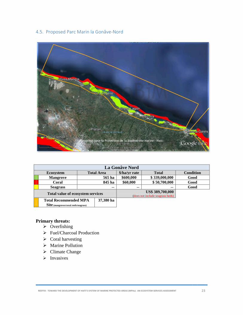
4.5. Proposed Parc Marin la Gonâve-Nord
La Gonâve Nord Ecosystem Total Area $/ha/yr rate Total Condition
Mangrove 565 ha $600,000 $ 339,000,000 Good
Coral 845 ha $60,000 $ 50,700,000 Good
Seagrass -- -- -- Good
Total value of ecosystem services US$ 389,700,000
(does not include seagrass beds)
Total Recommended MPA
Site (mangroves/coral reefs/seagrass)
37,380 ha
Primary threats:
Overfishing
Fuel/Charcoal Production
Coral harvesting
Marine Pollution
Climate Change
Invasives
REEFFIX - TOWARD THE DEVELOPMENT OF HAITI’S SYSTEM OF MARINE PROTECTED AREAS (MPAs): AN ECOSYSTEM SERVICES ASSESSMENT 24
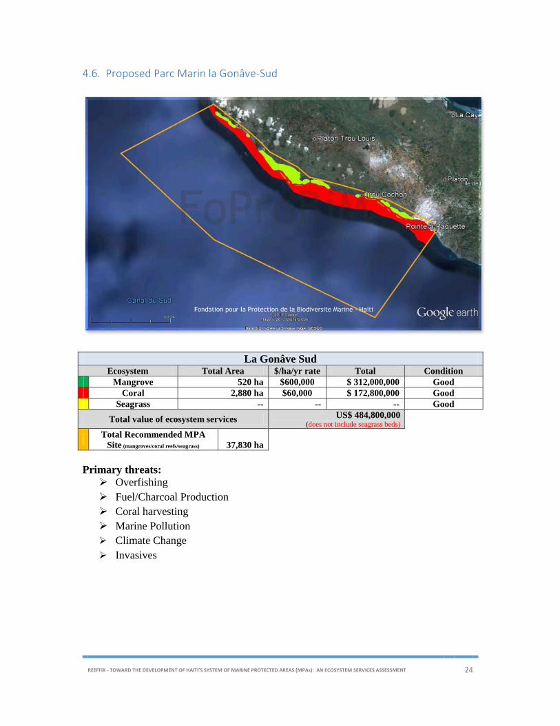
4.6. Proposed Parc Marin la Gonâve-Sud
La Gonâve Sud Ecosystem Total Area $/ha/yr rate Total Condition
Mangrove 520 ha $600,000 $ 312,000,000 Good
Coral 2,880 ha $60,000 $ 172,800,000 Good
Seagrass -- -- -- Good
Total value of ecosystem services US$ 484,800,000
(does not include seagrass beds)
Total Recommended MPA
Site (mangroves/coral reefs/seagrass)
37,830 ha
Primary threats:
Overfishing
Fuel/Charcoal Production
Coral harvesting
Marine Pollution
Climate Change
Invasives

REEFFIX - TOWARD THE DEVELOPMENT OF HAITI’S SYSTEM OF MARINE PROTECTED AREAS (MPAs): AN ECOSYSTEM SERVICES ASSESSMENT 25
4.7. Proposed Parc Marin des Rochelois
Rochelois Ecosystem Total Area $/ha/yr rate Total Condition
Mangrove 0 ha -- $ 0 --
Coral 5,720 ha $60,000 $ 343,200,000 Good
Seagrass -- -- -- Good
Total value of ecosystem services US$ 343,200,000
(does not include seagrass beds)
Total Recommended MPA
Site (mangroves/coral reefs/seagrass)
24,600 ha
Primary threats:
Overfishing
Climate Change
Invasives

REEFFIX - TOWARD THE DEVELOPMENT OF HAITI’S SYSTEM OF MARINE PROTECTED AREAS (MPAs): AN ECOSYSTEM SERVICES ASSESSMENT 26
4.8. Proposed Parc Marin Baradères/Cayemites
Baradères/Cayemites Ecosystem Total Area $/ha/yr rate Total Condition
Mangrove 2,050 ha $400,000 $ 820,000,000 Fair
Coral 7,285 ha $40,000 $ 291,400,000 Fair
Seagrass -- -- -- Good
Total value of ecosystem services US$ 1,111,400,000
(does not include seagrass beds)
Total Recommended MPA
Site (mangroves/coral reefs/seagrass)
152,300 ha
Primary threats:
Overfishing
Fuel/Charcoal Production
Coral harvesting
Climate Change
Invasives

REEFFIX - TOWARD THE DEVELOPMENT OF HAITI’S SYSTEM OF MARINE PROTECTED AREAS (MPAs): AN ECOSYSTEM SERVICES ASSESSMENT 27
4.9. Declared Parc Marin Ile-à-Vaches/Aquin
Ile-à-Vaches/Aquin Ecosystem Total Area $/ha/yr rate Total Conditions
Mangrove 2,309 ha $400,000 $ 923,600,000 Fair
Coral 5,520 ha $60,000 $ 331,200,000 Good
Seagrass -- -- -- Good
Total value of ecosystem services US$ 1,254,800,000
(does not include seagrass beds)
Total Recommended MPA Site (mangroves/coral reefs/seagrass)
214,690 ha
Primary threats:
Overfishing
Fuel/Charcoal Production
Coral harvesting
Marine Pollution
Sedimentation
Coastal development
Climate Change
Invasives
REEFFIX - TOWARD THE DEVELOPMENT OF HAITI’S SYSTEM OF MARINE PROTECTED AREAS (MPAs): AN ECOSYSTEM SERVICES ASSESSMENT 28
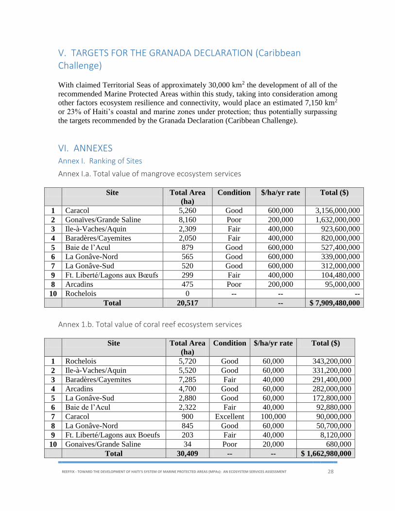
V. TARGETS FOR THE GRANADA DECLARATION (Caribbean Challenge)
With claimed Territorial Seas of approximately 30,000 km2 the development of all of the
recommended Marine Protected Areas within this study, taking into consideration among
other factors ecosystem resilience and connectivity, would place an estimated 7,150 km2
or 23% of Haiti’s coastal and marine zones under protection; thus potentially surpassing
the targets recommended by the Granada Declaration (Caribbean Challenge).
VI. ANNEXES Annex I. Ranking of Sites
Annex I.a. Total value of mangrove ecosystem services
Site Total Area
(ha)
Condition $/ha/yr rate Total ($)
1 Caracol 5,260 Good 600,000 3,156,000,000
2 Gonaïves/Grande Saline 8,160 Poor 200,000 1,632,000,000
3 Ile-à-Vaches/Aquin 2,309 Fair 400,000 923,600,000
4 Baradères/Cayemites 2,050 Fair 400,000 820,000,000
5 Baie de l’Acul 879 Good 600,000 527,400,000
6 La Gonâve-Nord 565 Good 600,000 339,000,000
7 La Gonâve-Sud 520 Good 600,000 312,000,000
9 Ft. Liberté/Lagons aux Bœufs 299 Fair 400,000 104,480,000
8 Arcadins 475 Poor 200,000 95,000,000
10 Rochelois 0 -- -- --
Total 20,517 -- $ 7,909,480,000
Annex 1.b. Total value of coral reef ecosystem services
Site Total Area
(ha)
Condition $/ha/yr rate Total ($)
1 Rochelois 5,720 Good 60,000 343,200,000
2 Ile-à-Vaches/Aquin 5,520 Good 60,000 331,200,000
3 Baradères/Cayemites 7,285 Fair 40,000 291,400,000
4 Arcadins 4,700 Good 60,000 282,000,000
5 La Gonâve-Sud 2,880 Good 60,000 172,800,000
6 Baie de l’Acul 2,322 Fair 40,000 92,880,000
7 Caracol 900 Excellent 100,000 90,000,000
8 La Gonâve-Nord 845 Good 60,000 50,700,000
9 Ft. Liberté/Lagons aux Boeufs 203 Fair 40,000 8,120,000
10 Gonaives/Grande Saline 34 Poor 20,000 680,000
Total 30,409 -- -- $ 1,662,980,000
REEFFIX - TOWARD THE DEVELOPMENT OF HAITI’S SYSTEM OF MARINE PROTECTED AREAS (MPAs): AN ECOSYSTEM SERVICES ASSESSMENT 29
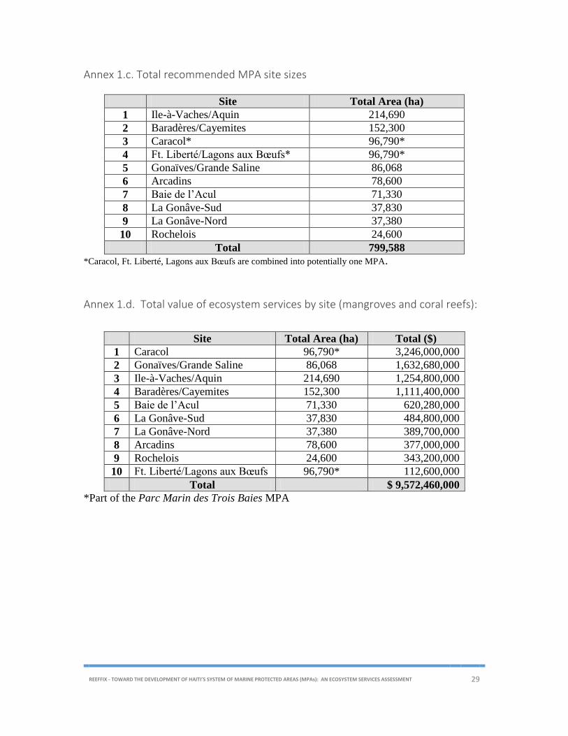
Annex 1.c. Total recommended MPA site sizes
Site Total Area (ha)
1 Ile-à-Vaches/Aquin 214,690
2 Baradères/Cayemites 152,300
3 Caracol* 96,790*
4 Ft. Liberté/Lagons aux Bœufs* 96,790*
5 Gonaïves/Grande Saline 86,068
6 Arcadins 78,600
7 Baie de l’Acul 71,330
8 La Gonâve-Sud 37,830
9 La Gonâve-Nord 37,380
10 Rochelois 24,600
Total 799,588
*Caracol, Ft. Liberté, Lagons aux Bœufs are combined into potentially one MPA.
Annex 1.d. Total value of ecosystem services by site (mangroves and coral reefs):
*Part of the Parc Marin des Trois Baies MPA
Site Total Area (ha) Total ($)
1 Caracol 96,790* 3,246,000,000
2 Gonaïves/Grande Saline 86,068 1,632,680,000
3 Ile-à-Vaches/Aquin 214,690 1,254,800,000
4 Baradères/Cayemites 152,300 1,111,400,000
5 Baie de l’Acul 71,330 620,280,000
6 La Gonâve-Sud 37,830 484,800,000
7 La Gonâve-Nord 37,380 389,700,000
8 Arcadins 78,600 377,000,000
9 Rochelois 24,600 343,200,000
10 Ft. Liberté/Lagons aux Bœufs 96,790* 112,600,000
Total $ 9,572,460,000

REEFFIX - TOWARD THE DEVELOPMENT OF HAITI’S SYSTEM OF MARINE PROTECTED AREAS (MPAs): AN ECOSYSTEM SERVICES ASSESSMENT 30
Annex II. Ecosystem Service Values by Cover Type for Marine Parks and Environs in the Caribbean (US$)
Habitat Type Ave.$/ha/yr Lower Bound Upper Bound
Beach 88,000 77,000 99,000
Beach near Dwelling 117,000 94,000 140,000
Coastal & Riparian Forest 9,271 5,542 13,000
Freshwater Stream 1,085 939 1,231
Freshwater Herbaceous Swamp 64,000 32,000 96,000
Grassland/pasture 118 118 118
Nearshore Aquatic Habitat 16,283 4,630 27,935
Coral Reef 60,000 20,000 100,000
Mangrove 550,000 200,000 900,000
Mangrove restoration 110,112 225 220,000
(Huber, R., OAS 2013)
REEFFIX - TOWARD THE DEVELOPMENT OF HAITI’S SYSTEM OF MARINE PROTECTED AREAS (MPAs): AN ECOSYSTEM SERVICES ASSESSMENT 31
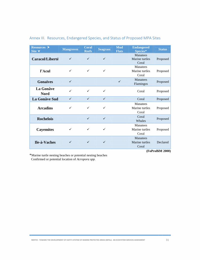
Annex III. Resources, Endangered Species, and Status of Proposed MPA Sites
Resources
Site Mangroves
Coral
Reefs Seagrass
Mud
Flats
Endangered
Species* Status
Caracol/Liberté
Manatees
Marine turtles
Coral
Proposed
l’Acul
Manatees
Marine turtles
Coral
Proposed
Gonaïves Manatees
Flamingos Proposed
La Gonâve
Nord Coral Proposed
La Gonâve Sud Coral Proposed
Arcadins
Manatees
Marine turtles
Coral
Proposed
Rochelois Coral
Whales Proposed
Cayemites
Manatees
Marine turtles
Coral
Proposed
Ile-à-Vaches
Manatees
Marine turtles
Coral
Declared
(FoProBiM 2000)
*Marine turtle nesting beaches or potential nesting beaches
Confirmed or potential location of Acropora spp.

Page 32 of 35
Annex IV. Primary Characteristics and Threats to Proposed MPA Sites
Threats to
Site Mangroves Coral Reefs Seagrass Mud Flats Threats
Caracol/Liberté
Overfishing1, Fuel/Charcoal Production, Coral harvesting, Salt pan
development, Industrial Park2, Marine Pollution, Sedimentation, Coastal
development, Climate Change, Invasives3, Port facility4
l’Acul Overfishing1, Fuel/Charcoal Production, Coral harvesting, Marine
Pollution, Sedimentation, Coastal development, Climate Change,
Invasives3
Gonaïves/Grande
Saline
Overfishing1, Fuel/Charcoal Production, Salt pan development, Marine
Pollution, Sedimentation, Coastal development, Climate Change,
Invasives3
La Gonâve Nord Overfishing1, Fuel/Charcoal Production, Coral harvesting, Marine
Pollution, Climate Change, Invasives3
La Gonâve Sud Overfishing1, Fuel/Charcoal Production, Coral harvesting, Marine
Pollution, Climate Change, Invasives3
Arcadins
Overfishing1, Fuel/Charcoal Production, Coral harvesting, Marine
Pollution, Sedimentation, Coastal development, Climate Change,
Invasives3
Rochelois Overfishing1, Climate Change, Invasives3
Baraderes/Cayemites Overfishing1, Fuel/Charcoal Production, Coral harvesting, Climate
Change, Invasives3
Ile-à-Vaches
Overfishing1, Fuel/Charcoal Production, Coral harvesting, Marine
Pollution, Sedimentation, Coastal development, Climate Change,
Invasives3
(FoProBiM 2000) 1 Overfishing: including lobster, conch, sea turtles, and sea cucumbers 2 Industrial Park: development of the Parc Industriel de Caracol (increased potential for marine and terrestrial pollution, increased exploitation of resources including
mangroves) 3 Invasives; particularly the Pacific Lionfish 4 Port Facility; development of port facility in the Ft. Liberté area

Page 33 of 35
Annex V. Draft Presidential Decree for the Creation of a Marine Protected Area
Draft Presidental Decree (Arrêté) for the creation of the
« Parc Marin XXXXX »
Vu les Articles 36, 36-1, 36-5, 52-1.h, 136, 138, 215, 253, 254, et 256 de la Constitution ;
Vu la Loi du 6 juin 1963 établissant les règles spéciales relatives à l’habitation et à
l’aménagement des villes et des campagnes en vue de développer l’urbanisme ;
Vu le décret du 18 mars 1968 dénommant “Parcs Nationaux ou Sites Naturels “ toutes
étendues de terres boisées ou pas sur lesquelles sont établis des monuments historiques ou
sites naturels” ;
Vu le décret du 27 Octobre 1978 sur la pêche ;
et toute autre loi, arrêté, ou décret qui pourrait être applicable ;
Considérant que l'Etat Haïtien exerce sa souveraineté sur les eaux nationales, sur le plateau
continental, la zone contigüe, la zone économique exclusive, sur les sous-sols marins et
fluviaux.
Considérant qu’il lui échoit l'obligation d'organiser et de réglementer la protection et
l'exploitation de la faune et de la flore qui y croissent;
Considérant que la rationalisation de l'exploitation des ressources biologiques aquatiques exige
la protection de la faune et de la flore maritimes et fluviales, le contrôle des méthodes de capture
et des engins utilisés, ainsi que celui de la pression de pêche face au stock disponible.
Considérant que l'érosion de plus en plus accentuée du sol des régions montagneuses
constitue un très grave danger pour l'avenir du pays;
Considérant que le site désormais dénommé Parc Marin de XXXXX est d’une importance
majeure pour l’environnement naturel d’Haïti par ses richesses biologiques, historiques,
culturelles, et scientifiques et qu’il incombe a l’Etat d’en assurer la protection et la
préservation;
Considérant qu’il convient de déclarer le site désormais dénommé Parc de XXXXX Zone
Réservée;
Sur le rapport des Ministres de l’Environnement, du Tourisme, de l’Agriculture des
Ressources Naturelles et le Développement Rural, et de la Planification et après délibération
en Conseil des Ministres.

Page 34 of 35
Arrêté
Article 1.-
Est déclarée Zone Réservée la zone désormais dénommé Parc de XXXXX délimitée par le
littoral et haute mer suivant les coordonnées GPS : Pin (1) XXXN, XXXW; Pin (2) XXXN,
XXXW; Pin (3) XXXN, XXXW; Pin (4) XXXN, XXXW.
Cette zone comprend :
tous les mangliers situés à l’intérieur ou adjacents à cette zone y compris une zone de
tampon de 25 mètres autour des mangliers ;
tous les récifs ;
toutes les iles ou ilots ;
tous les herbiers ;
tous les étangs séparés de la mer par moins de 100 mètres de terre ;
toutes les épaves ;
toute forme biologique ;
le fonds marin ;
et toutes les formes et structures naturelles ou créées par l'homme.
Cette zone comprend tout zone décrite comme plage ou littoral et, le cas échéant, s’étant
jusqu’au niveau de la marée haute de la mer.
Le Parc Marin de XXXXX est déclaré Zone Réservée en vue de la mise en place de
différentes zones de gestion visant 1) la protection de l’environnement 2) la protection de la
biodiversité 3) le développement durable du tourisme 4) l’exploitation durable des
ressources côtières, marines, et autres, spécifiquement les ressources de pêche 5)
l’aménagement durable des villes et des campagnes.
Article 2.-
Tous les droits de propriété dans cette zone seront respectés. Toute activité et tout
développement dans cette zone ou dans les zones adjacentes ne devront en aucun cas aller à
l’encontre des stipulations de l’Article 1 susmentionné.
Page 35 of 35
Article 3.-
Un comité composé de membres du secteur publique et privé sera mis en place et sera
chargé de la surveillance et de la gestion durable de cette zone.
Article 4.- Le présent Arrêté sera publié et exécuté à la diligence des Ministres de l’Environnement, du
Tourisme, de l’Agriculture des Ressources Naturelles et du Développement Rural, et de la
Planification, chacun en ce qui le concerne.
Donné au Palais National, à Port-au-Prince, le ___________________ 20XX, An XXX de
l’Indépendance.
Par le Président
Le Premier Ministre
Le Ministre de l’Environnement
Le Ministre du Tourisme
Le Ministre de l’Agriculture, des Ressources Naturelles et du Développement Rural
Le Ministre de la Planification