folio of riparian conditions and prospective actions · (map id) location (river miles) ... 3-5...
TRANSCRIPT

Merced River Riparian Corridor Restoration in Yosemite Valley Restoration Concept Designs
A-1
REACH 1

Merced River Riparian Corridor Restoration in Yosemite Valley Restoration Concept Designs
A-2
Merced River Riparian Corridor Restoration in Yosemite Valley Restoration Concept Designs
A-3
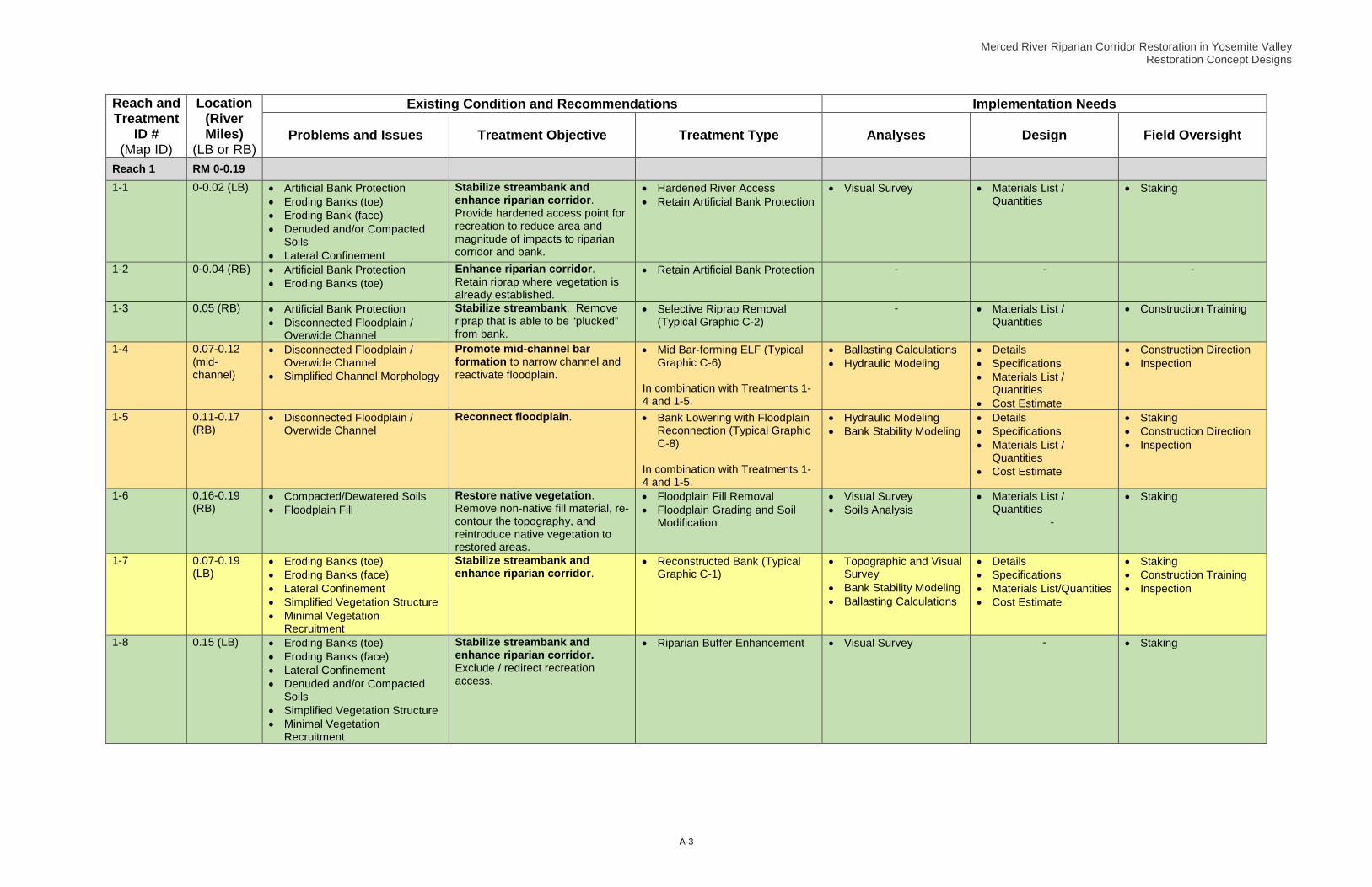
Reach and Treatment
ID # (Map ID)
Location (River Miles)
(LB or RB)
Existing Condition and Recommendations Implementation Needs
Problems and Issues Treatment Objective Treatment Type Analyses Design Field Oversight
Reach 1 RM 0-0.19
1-1 0-0.02 (LB) • Artificial Bank Protection • Eroding Banks (toe) • Eroding Bank (face) • Denuded and/or Compacted
Soils • Lateral Confinement
Stabilize streambank and enhance riparian corridor. Provide hardened access point for recreation to reduce area and magnitude of impacts to riparian corridor and bank.
• Hardened River Access • Retain Artificial Bank Protection
• Visual Survey • Materials List / Quantities
• Staking
1-2 0-0.04 (RB) • Artificial Bank Protection • Eroding Banks (toe)
Enhance riparian corridor. Retain riprap where vegetation is already established.
• Retain Artificial Bank Protection - - -
1-3 0.05 (RB) • Artificial Bank Protection • Disconnected Floodplain /
Overwide Channel
Stabilize streambank. Remove riprap that is able to be “plucked” from bank.
• Selective Riprap Removal (Typical Graphic C-2)
- • Materials List / Quantities
• Construction Training
1-4 0.07-0.12 (mid-channel)
• Disconnected Floodplain / Overwide Channel
• Simplified Channel Morphology
Promote mid-channel bar formation to narrow channel and reactivate floodplain.
• Mid Bar-forming ELF (Typical Graphic C-6)
In combination with Treatments 1-4 and 1-5.
• Ballasting Calculations • Hydraulic Modeling
• Details • Specifications • Materials List /
Quantities • Cost Estimate
• Construction Direction • Inspection
1-5 0.11-0.17 (RB)
• Disconnected Floodplain / Overwide Channel
Reconnect floodplain.
• Bank Lowering with Floodplain Reconnection (Typical Graphic C-8)
In combination with Treatments 1-4 and 1-5.
• Hydraulic Modeling • Bank Stability Modeling
• Details • Specifications • Materials List /
Quantities • Cost Estimate
• Staking • Construction Direction • Inspection
1-6 0.16-0.19 (RB)
• Compacted/Dewatered Soils • Floodplain Fill
Restore native vegetation. Remove non-native fill material, re-contour the topography, and reintroduce native vegetation to restored areas.
• Floodplain Fill Removal • Floodplain Grading and Soil
Modification
• Visual Survey • Soils Analysis
• Materials List / Quantities
-
• Staking
1-7 0.07-0.19 (LB)
• Eroding Banks (toe) • Eroding Banks (face) • Lateral Confinement • Simplified Vegetation Structure • Minimal Vegetation
Recruitment
Stabilize streambank and enhance riparian corridor.
• Reconstructed Bank (Typical Graphic C-1)
• Topographic and Visual Survey
• Bank Stability Modeling • Ballasting Calculations
• Details • Specifications • Materials List/Quantities • Cost Estimate
• Staking • Construction Training • Inspection
1-8 0.15 (LB) • Eroding Banks (toe) • Eroding Banks (face) • Lateral Confinement • Denuded and/or Compacted
Soils • Simplified Vegetation Structure • Minimal Vegetation
Recruitment
Stabilize streambank and enhance riparian corridor. Exclude / redirect recreation access.
• Riparian Buffer Enhancement • Visual Survey
- • Staking

Merced River Riparian Corridor Restoration in Yosemite Valley Restoration Concept Designs
A-4
REACH 2

Merced River Riparian Corridor Restoration in Yosemite Valley Restoration Concept Designs
A-5
Merced River Riparian Corridor Restoration in Yosemite Valley Restoration Concept Designs
A-6
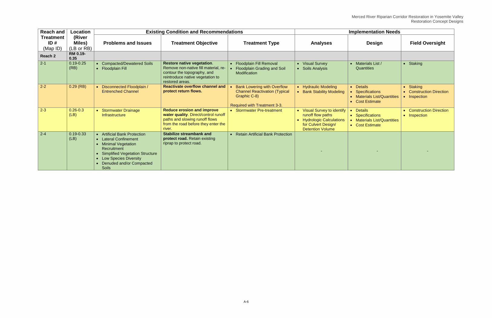
Reach and Treatment
ID # (Map ID)
Location (River Miles)
(LB or RB)
Existing Condition and Recommendations Implementation Needs
Problems and Issues Treatment Objective Treatment Type Analyses Design Field Oversight
Reach 2 RM 0.19-0.35
2-1 0.19-0.25 (RB)
• Compacted/Dewatered Soils • Floodplain Fill
Restore native vegetation. Remove non-native fill material, re-contour the topography, and reintroduce native vegetation to restored areas.
• Floodplain Fill Removal • Floodplain Grading and Soil
Modification
• Visual Survey • Soils Analysis
• Materials List / Quantities
• Staking
2-2 0.29 (RB) • Disconnected Floodplain / Entrenched Channel
Reactivate overflow channel and protect return flows.
• Bank Lowering with Overflow Channel Reactivation (Typical Graphic C-8)
Required with Treatment 3-3.
• Hydraulic Modeling • Bank Stability Modeling
• Details • Specifications • Materials List/Quantities • Cost Estimate
• Staking • Construction Direction • Inspection
2-3 0.26-0.3 (LB)
• Stormwater Drainage Infrastructure
Reduce erosion and improve water quality. Direct/control runoff paths and slowing runoff flows from the road before they enter the river.
• Stormwater Pre-treatment
• Visual Survey to identify runoff flow paths
• Hydrologic Calculations for Culvert Design/ Detention Volume
• Details • Specifications • Materials List/Quantities • Cost Estimate
• Construction Direction • Inspection
2-4 0.19-0.33 (LB)
• Artificial Bank Protection • Lateral Confinement • Minimal Vegetation
Recruitment • Simplified Vegetation Structure • Low Species Diversity • Denuded and/or Compacted
Soils
Stabilize streambank and protect road. Retain existing riprap to protect road.
• Retain Artificial Bank Protection
- - -

Merced River Riparian Corridor Restoration in Yosemite Valley Restoration Concept Designs
A-7
REACH 3
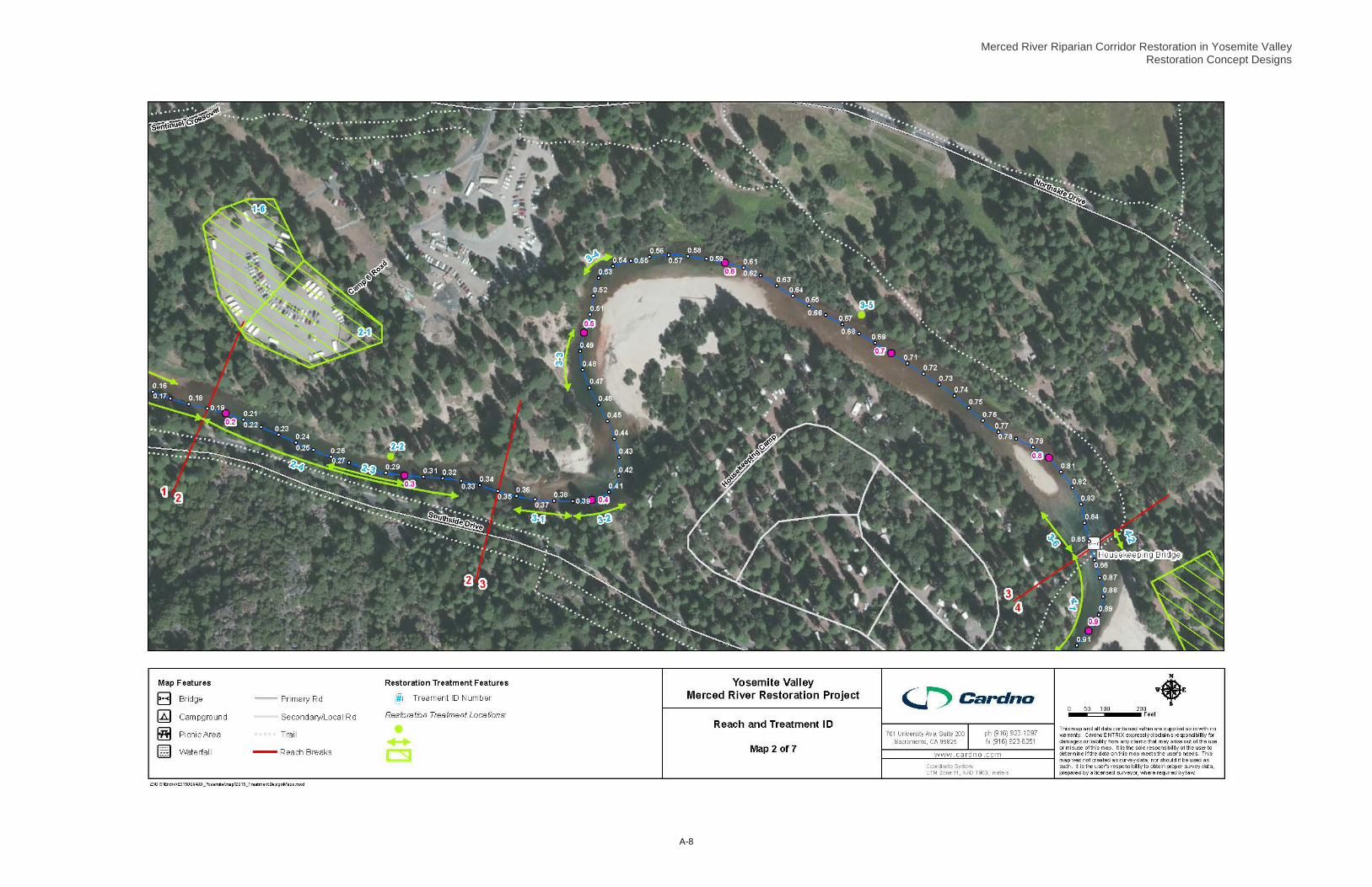
Merced River Riparian Corridor Restoration in Yosemite Valley Restoration Concept Designs
A-8

Merced River Riparian Corridor Restoration in Yosemite Valley Restoration Concept Designs
A-9
Reach and Treatment
ID # (Map ID)
Location (River Miles)
(LB or RB)
Existing Condition and Recommendations Implementation Needs
Problems and Issues Treatment Objective Treatment Type Analyses Design Field Oversight
Reach 3 RM 0.35-0.85
3-1 0.36-0.39 (LB)
• Eroding Banks (toe) • Eroding Banks (face) • Simplified Vegetation Structure • Low Plant Species Diversity • Minimal Vegetation
Recruitment
Stabilize streambank and enhance riparian corridor (incorporate existing large wood).
• Reconstructed Bank (Typical Graphic C-1)
• Topographic and/or Quantity Survey
• Hydraulic Modeling • Ballasting Calculations
• Details • Specifications • Materials List/Quantities • Cost Estimate
• Staking • Construction Direction • Inspection
3-2 0.39-0.41 (LB)
• Eroding Banks (toe) • Eroding Banks (face) • Denuded and/or Compacted
Soils
Stabilize streambank and enhance riparian corridor (incorporate existing rock).
• Reconstructed Bank (Typical Graphic C-1)
• Topographic and/or Quantity Survey
• Hydraulic Modeling • Ballasting Calculations
• Details • Specifications • Materials List/Quantities • Cost Estimate
• Staking • Construction Direction • Inspection
3-3 0.47-0.50 (RB)
• Disconnected Floodplain / Entrenched Channel
Reactivate floodplain and enhance riparian corridor. Direct high flows into historic swale and onto the floodplain and return flows to the main channel.
• Bank Lowering with Overflow Channel Reactivation (Typical Graphic C-8)
Required with Treatment 2-2
• Topographic and/or Quantity Survey
• Hydraulic Modeling
• Details • Specifications • Materials List/Quantities • Cost Estimate
• Staking • Construction Direction • Inspection
3-4 0.53-0.54 (RB)
• Eroding Banks (toe) • Eroding Banks (face) • Denuded and/or Compacted
Soils
Enhance riparian corridor. Exclude/ redirect recreation access.
• Riparian Buffer Enhancement • Visual Survey
-
• Staking
3-5 0.67 (RB) • Disconnected Floodplain / Entrenched Channel
Reactivate overflow channels and enhance riparian corridor. Direct high flows into historic swale and onto the floodplain and return flows to the main channel.
• Bank Lowering with Overflow Channel Reactivation (Typical Graphic C-8)
• Topographic and Visual Survey
• Details • Specifications • Materials List/Quantities • Cost Estimate
• Staking • Construction Direction • Inspection
3-6 0.83-0.85 (LB)
• Artificial Bank Protection • Eroding Banks (toe) • Eroding Banks (face) • Localized Channel Scour • Lateral Confinement
Stabilize streambank and enhance riparian corridor. Maintain/repair existing riprap wall and plant vegetation to enhance streambank corridor.
• Retain Artificial Bank Protection • Reconstructed Bank (Typical
Graphic C-1)
• Topographic and/or Quantity Survey
• Bank Stability Modeling • Ballasting Calculations
• Details • Specifications • Materials List/Quantities • Cost Estimate
• Staking • Construction Direction • Inspection

Merced River Riparian Corridor Restoration in Yosemite Valley Restoration Concept Designs
A-10
REACH 4

Merced River Riparian Corridor Restoration in Yosemite Valley Restoration Concept Designs
A-11

Merced River Riparian Corridor Restoration in Yosemite Valley Restoration Concept Designs
A-12
Reach and Treatment
ID # (Map ID)
Location (River Miles)
(LB or RB)
Existing Condition and Recommendations Implementation Needs
Problems and Issues Treatment Objective Treatment Type Analyses Design Field Oversight
Reach 4 RM 0.85-1.22
4-1 0.85-0.92 (LB)
• Bridge Alignment (?) • Artificial Bank Protection • Eroding Banks (toe) • Eroding Banks (face) • Denuded and/or Compacted
Soils • Minimal Vegetation
Recruitment • Low Species Diversity • Simplified Vegetation Structure
Stabilize streambank and enhance riparian corridor. Retain rock at the toe, plant native vegetation on the upper bank, and exclude recreation access.
• Selective Riprap Removal (Typical Graphic C-2)
• Riparian Buffer Enhancement • Bank Grading and Soil
Modification
• Hydraulic Modeling • Bank Stability Modeling
• Details • Materials List/Quantities
• Staking • Inspection
4-2 0.85-0.86 (RB)
• Bridge Alignment (?) Artificial Bank Protection
• Denuded and/or Compacted Soils
Enhance riparian corridor. Exclude/ redirect recreation access.
• Retain Artificial Bank Protection • Riparian Buffer Enhancement • Hardened River Access
• Visual Survey
-
• Staking
4-3 0.92-0.94 (LB)
• Disconnected Floodplain / Overwide Channel
• Artificial Bank Protection • Simplified Channel Morphology • Denuded and/or Compacted
Soils • Minimal Vegetation
Recruitment • Simplified Vegetation Structure • Low Species Diversity
Stabilize streambank and enhance riparian corridor.
• Reconstructed Bank (Typical Graphic C-1)
• Selective Riprap Removal (Typical Graphic C-2)
• Riparian Buffer Enhancement • Bank Grading and Soil
Modification
• Topographic and/or Quantity Survey
• Hydraulic Modeling • Ballasting Calculations
• Details • Specifications • Materials List/Quantities • Cost Estimate
• Staking • Construction Direction • Inspection
4-4 0.99-1.05 (LB)
• Eroding Banks (face) • Denuded and/or Compacted
Soils • Minimal Vegetation
Recruitment • Simplified Vegetation Structure • Low Species Diversity • Unstable Tributary Confluence
Stabilize streambank and enhance riparian corridor.
• Reconstructed Bank (Typical Graphic C-1)
• Brush Layering • Floodplain-building Logs
(Typical Graphic C-5)
• Topographic and/or Quantity Survey
• Hydraulic Calculations • Ballasting Calculations
• Details • Specifications • Materials List/Quantities • Cost Estimate
• Staking • Construction Direction • Inspection
4-5 1.11-1.13 (RB)
• Artificial Bank Protection • Eroding Banks (toe) • Eroding Banks (face) • Denuded and/or Compacted
Soils • Simplified Vegetation Structure • Low Species Diversity
Stabilize streambank and enhance riparian corridor.
• Selective Riprap Removal (Typical Graphic C-2)
• Visual Survey
-
• Staking
4-6 0.88-1.21 (RB)
• Compacted / Dewatered Soils • Disconnected Floodplain /
Entrenched Channel • Simplified Vegetation Structure • Low Species Diversity
Enhance riparian corridor. Remove dense pines; decompact soils, create microtopographic variation, and plant with various native floodplain species.
• Floodplain Grading and Soil Modification
• Visual Survey
• Specifications • Materials List/Quantities
• Staking
Reach 4 RM 0.85-1.22

Merced River Riparian Corridor Restoration in Yosemite Valley Restoration Concept Designs
A-13
Reach and Treatment
ID # (Map ID)
Location (River Miles)
(LB or RB)
Existing Condition and Recommendations Implementation Needs
Problems and Issues Treatment Objective Treatment Type Analyses Design Field Oversight
4-7 1.05 to 1.16 (LB)
• Disconnected Floodplain / Overwide Channel
Promote bar formation and narrow channel. Place additional wood along the streambank to promote continued deposition of bar-forming materials.
• Lateral Bar-forming ELF (Typical Graphic C-7)
• Hydraulic Modeling • Ballasting Calculations
• Details • Specifications • Materials List/Quantities • Cost Estimate
• Staking • Construction Direction • Inspection
4-8 1.19-1.22 (LB)
• Localized Channel Scour • Eroding Banks (toe) • Eroding Banks (face) • Denuded and/or Compacted
Soils • Minimal Vegetation
Recruitment • Simplified Vegetation Structure • Low Plant Species Diversity
Stabilize streambank and enhance riparian corridor.
• Crib Structure (Typical Graphic C-3)
• Topographic and/or Quantity Survey
• Ballasting Calculations
• Details • Specifications • Materials List/Quantities • Cost Estimate
• Staking • Construction Direction • Inspection

Merced River Riparian Corridor Restoration in Yosemite Valley Restoration Concept Designs
A-14
REACH 5

Merced River Riparian Corridor Restoration in Yosemite Valley Restoration Concept Designs
A-15

Merced River Riparian Corridor Restoration in Yosemite Valley Restoration Concept Designs
A-16
Reach and Treatment
ID # (Map ID)
Location (River Miles)
(LB or RB)
Existing Condition and Recommendations Implementation Needs
Problems and Issues Treatment Objective Treatment Type Analyses Design Field Oversight
Reach 5 RM 1.22-1.51
5-1 1.24-1.51 (RB)
• Floodplain Fill • Denuded and/or Compacted
Soils • Minimal Vegetation
Recruitment • Low Species Diversity • Simplified Vegetation Structure
Enhance riparian corridor. Exclude/ redirect recreation access.
• Riparian Buffer Enhancement • Visual Survey
-
• Staking
5-2 1.22-1.24 (RB)
• Denuded and/or Compacted Soils
Enhance riparian corridor. Exclude/ redirect recreation access.
• Hardened River Access • Visual Survey • Materials List/Quantities
• Staking
5-3 1.23 to 1.28 (LB)
• Artificial Bank Protection • Simplified Vegetation Structure • Bridge Alignment (?)
Stabilize streambank and enhance riparian corridor. Retain riprap to maintain stability and construct flow deflecting ELF to deflect flows away from the bank.
• Flow-deflecting ELF (Typical Graphic C-4)
• Selective Riprap Removal (Typical Graphic C-2)
• Bank Grading and Soil Modification
• Topographic and/or Quantity Survey
• Hydraulic Modeling • Bank Stability Modeling • Ballasting Calculations
• Details • Specifications • Materials List/Quantities • Cost Estimate
• Staking • Construction Direction • Inspection
5-4 1.3 to 1.37 (LB)
• Disconnected Floodplain/ Overwide Channel
• Simplified Channel Morphology • Minimal Vegetation
Recruitment • Simplified Vegetation Structure
Promote channel narrowing and enhance riparian corridor. Bury logs near channel toe so that flows overtop logs and sediment settles behind logs, enlarge incipient floodplain surfaces and plant.
• Floodplain-building Logs (Typical Graphic C-5)
Combine with Treatments 5-5 and 5-6
• Visual Survey • Details • Specifications • Materials List/Quantities • Cost Estimate
• Staking • Construction Training • Inspection
5-5 1.37 to 1.41 (RB)
• Disconnected Floodplain/ Overwide Channel
• Simplified Channel Morphology • Minimal Vegetation
Recruitment • Simplified Vegetation Structure
Promote channel narrowing and enhance riparian corridor. Bury logs near channel toe so that flows overtop logs and sediment settles behind logs, enlarge incipient floodplain surfaces and plant.
• Floodplain-building Logs (Typical Graphic C-5)
Combine with Treatments 5-4 and 5-6
• Visual Survey • Details • Specifications • Materials List/Quantities • Cost Estimate
• Staking • Construction Training • Inspection
5-6 1.41-1.44 (LB)
• Disconnected Floodplain/ Overwide Channel
• Simplified Channel Morphology
Diversify channel morphology. Prompt mid-channel bar-formation, raising the bed profile.
• Mid Bar-forming ELF (Typical Graphic C-6)
Combine with Treatments 5-4 and 5-5
• Visual Survey • Ballasting Calculations
• Details • Specifications • Materials List/Quantities • Cost Estimate
• Staking • Construction Direction • Inspection
5-7 1.37-1.47 (LB)
• Disconnected Floodplain / Entrenched Channel
• Minimal Vegetation Recruitment
• Simplified Vegetation Structure
Stabilize streambank and enhance riparian corridor. Reactivate overflow channel and protect return flows (from Treatment 7-2).
• Bank Lowering with Overflow Channel Reactivation (Typical Graphic C-8)
• Reconstructed Bank (Typical Graphic C-1)
Required with Treatment 7-2
• Topographic and/or Quantity Survey
• Hydraulic Modeling • Bank Stability Modeling • Ballasting Calculations
• Details • Specifications • Materials List/Quantities
Cost Estimate
• Staking • Construction Direction • Inspection
5-8 1.47-1.50 (RB)
• Artificial Bank Protection Stabilize streambank while protecting existing vegetation.
• Retain Artificial Bank Protection - - -

Merced River Riparian Corridor Restoration in Yosemite Valley Restoration Concept Designs
A-17
REACH 6

Merced River Riparian Corridor Restoration in Yosemite Valley Restoration Concept Designs
A-18

Merced River Riparian Corridor Restoration in Yosemite Valley Restoration Concept Designs
A-19
Reach and Treatment
ID # (Map ID)
Location (River Miles)
(LB or RB)
Existing Condition and Recommendations Implementation Needs
Problems and Issues Treatment Objective Treatment Type Analyses Design Field Oversight
Reach 6 RM 1.51-1.74
Pending Investigation of the Reach-Specific Study

Merced River Riparian Corridor Restoration in Yosemite Valley Restoration Concept Designs
A-20
REACH 7
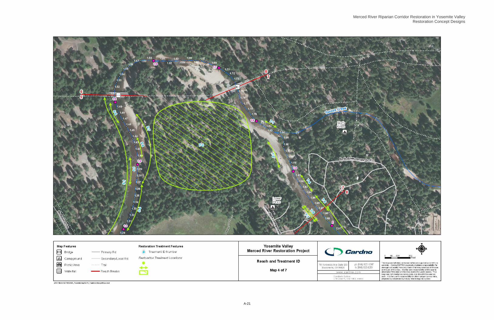
Merced River Riparian Corridor Restoration in Yosemite Valley Restoration Concept Designs
A-21

Merced River Riparian Corridor Restoration in Yosemite Valley Restoration Concept Designs
A-22
Reach and Treatment
ID # (Map ID)
Location (River Miles)
(LB or RB)
Existing Condition and Recommendations Implementation Needs
Problems and Issues Treatment Objective Treatment Type Analyses Design Field Oversight
Reach 7 RM 1.74-1.97
7-1 1.81-1.83 (RB)
• Eroding Banks (face)
Stabilize streambank erosion and enhance riparian corridor. Construct Crib Structure (Typical Graphic C-3) with plantings to protect bank from continued bank erosion.
• Crib Structure (Typical Graphic C-3)
Benefits Treatment 7-2 and 7-3
• Hydraulic Modeling Topographic and/or Quantity Survey
• Ballasting Calculations
• Details • Specifications • Materials List/Quantities • Cost Estimate
• Staking • Construction Direction • Inspection
7-2 1.84-1.89 (LB)
• Disconnected Floodplain / Entrenched Channel
• Bridge Alignment (?)
Reconnect floodplain and enhance riparian corridor. Reconnect historic swale to release flow onto floodplain during high flows.
• Bank Lowering with Floodplain Reconnection (Typical Graphic C-8)
• LWD Relocation Required with Treatment5-7
• Hydraulic Modeling • Bank Stability Modeling
• Details • Specifications • Materials List/Quantities • Cost Estimate
• Staking • Construction Direction • Inspection
7-3 1.84-1.89 (LB)
• Compacted / Dewatered Soils • Floodplain Fill • Simplified Vegetation Structure • Low Species Diversity
Enhance riparian corridor. Remove dense pines; decompact soils and create microtopographic variation; plant with diversity of native floodplain species.
• Floodplain Grading and Soil Modification
• LWD Relocation Benefits Treatments 5-7, 7-1, 7-2
• Visual Survey • Specifications • LWD Maintenance
Protocol
• Staking • Construction Training
7-4 1.91-1.94 (RB)
• Disconnected Floodplain / Overwide Channel
• Simplified Vegetation Structure • Low Species Diversity • Minimal Vegetation
Recruitment
Promote channel narrowing and enhance riparian corridor. Construct Lateral Bar-forming ELF (Typical Graphic C-7) to promote continued deposition. Exclude recreation access to protect riparian corridor and streambanks.
• Lateral Bar-forming ELF (Typical Graphic C-7)
• Riparian Buffer Enhancement
• Visual and Quantity Survey
• Ballasting Calculations
• Details • Specifications • Materials List/Quantities • Cost Estimate
• Staking • Construction Direction • Inspection
7-5 1.95-1.98 (LB)
• Disconnected Floodplain / Overwide Channel
Stabilize streambank and enhance riparian corridor. Incorporate standing and down large woody material.
• Reconstructed Bank (Typical Graphic C-1)
• Brush Layering
• Visual and Quantity Survey
• Ballasting Calculations
• Details • Specifications • Materials List/Quantities • Cost Estimate
• Staking • Construction Direction • Inspection
7-6 1.95-1.98 (RB)
• Denuded and/or Compacted Soils
• Simplified Vegetation Structure • Low Species Diversity • Minimal Vegetation
Recruitment
Enhance riparian corridor. Exclude/ redirect recreation access.
• Riparian Buffer Enhancement • Visual Survey
-
• Staking
7-7 1.95-1.98 (LB)
• Denuded and/or Compacted Soils
• Simplified Vegetation Structure • Low Species Diversity • Minimal Vegetation
Recruitment
Enhance riparian corridor. Exclude/ redirect recreation access.
• Riparian Buffer Enhancement • Visual Survey
-
• Staking

Merced River Riparian Corridor Restoration in Yosemite Valley Restoration Concept Designs
A-23
REACH 8

Merced River Riparian Corridor Restoration in Yosemite Valley Restoration Concept Designs
A-24

Merced River Riparian Corridor Restoration in Yosemite Valley Restoration Concept Designs
A-25
Reach and Treatment
ID # (Map ID)
Location (River Miles)
(LB or RB)
Existing Condition and Recommendations Implementation Needs
Problems and Issues Treatment Objective Treatment Type Analyses Design Field Oversight
Reach 8 RM 1.97-2.18
8-1 1.97-2.14 (RB)
• Eroding Banks (toe) • Eroding Banks (face) • Floodplain Fill • Lateral Confinement • Denuded and/or Compacted
Soils • Simplified Vegetation Structure • Minimal Vegetation
Recruitment • Simplified Channel Morphology
Stabilize streambanks and enhance riparian corridor. Plant native vegetation and exclude/redirect recreation access.
• Brush Layering • Riparian Buffer Enhancement
• Visual Survey • Specifications • Staking
8-2 2.14-2.18 (RB)
• Floodplain Encroachment /Fill • Lateral Confinement • Denuded and/or Compacted
Soils • Simplified Vegetation Structure • Low Species Diversity • Minimal Vegetation
Recruitment
Enhance riparian corridor. Exclude/ redirect recreation access.
• Hardened River Access • Visual Survey and Quantity Survey
• Specifications • Materials List/Quantities
• Staking
8-3 2.04-2.11 (LB)
• Eroding Banks (toe) • Eroding Banks (face) • Denuded and/or Compacted
Soils • Simplified Vegetation Structure • Minimal Vegetation
Recruitment
Stabilize streambank and enhance riparian corridor. Regrade soils after road removal for planting, plant native vegetation, and exclude/redirect recreation access.
• Riparian Buffer Enhancement • Bank Grading and Soil
Modification • Floodplain Grading and Soil
Modification
• Visual Survey • Specifications • Materials List/Quantities
• Staking
8-4 2.16-2.18 (LB)
• Artificial Bank Protection • Denuded and/or Compacted
Soils
Stabilize streambanks. Maintain existing riprap.
• Retain Artificial Bank Protection - - -

Merced River Riparian Corridor Restoration in Yosemite Valley Restoration Concept Designs
A-26
REACH 9

Merced River Riparian Corridor Restoration in Yosemite Valley Restoration Concept Designs
A-27

Merced River Riparian Corridor Restoration in Yosemite Valley Restoration Concept Designs
A-28
Reach and Treatment
ID # (Map ID)
Location (River Miles)
(LB or RB)
Existing Condition and Recommendations Implementation Needs
Problems and Issues Treatment Objective Treatment Type Analyses Design Field Oversight
Reach 9 RM 2.18-2.71
9-1 2.18-2.21 (LB and RB)
• Artificial Bank Protection • Eroding Banks (face) • Denuded and/or Compacted
Soils • Simplified Vegetation Structure • Minimal Vegetation
Recruitment • Lateral Confinement
Stabilize streambanks. Maintain existing riprap.
• Retain Artificial Bank Protection • Bank Grading and Soil
Modification
• Visual Survey
-
• Staking
9-2 2.21-2.24 (LB)
• Stormwater Drainage Infrastructure
Enhance riparian corridor. Restore functions to campground removal area
• Stormwater Pretreatment • Floodplain Grading and Soil
Modification
• Visual Survey to identify runoff flow paths
• Hydrologic Analysis
• Details • Specifications • Materials List/Quantities • Cost Estimate
• Construction Direction • Inspection
9-3 2.18-2.53 (LB)
• Eroding Banks (toe) • Eroding Banks (face) • Denuded and/or Compacted
Soils • Unstable Tributary Confluence
Enhance riparian corridor. Regrade trail removal area for planting; plant; and exclude recreation access.
• Floodplain Grading and Soil Modification
• Riparian Buffer Enhancement
• Visual Survey • Specifications • Staking

Merced River Riparian Corridor Restoration in Yosemite Valley Restoration Concept Designs
A-29
REACH 10

Merced River Riparian Corridor Restoration in Yosemite Valley Restoration Concept Designs
A-30
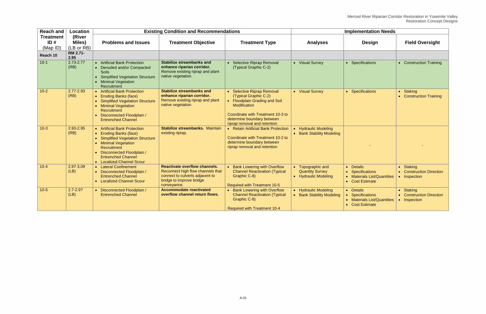
Merced River Riparian Corridor Restoration in Yosemite Valley Restoration Concept Designs
A-31
Reach and Treatment
ID # (Map ID)
Location (River Miles)
(LB or RB)
Existing Condition and Recommendations Implementation Needs
Problems and Issues Treatment Objective Treatment Type Analyses Design Field Oversight
Reach 10 RM 2.71-2.95
10-1 2.73-2.77 (RB)
• Artificial Bank Protection • Denuded and/or Compacted
Soils • Simplified Vegetation Structure • Minimal Vegetation
Recruitment
Stabilize streambanks and enhance riparian corridor. Remove existing riprap and plant native vegetation.
• Selective Riprap Removal (Typical Graphic C-2)
• Visual Survey • Specifications • Construction Training
10-2 2.77-2.93 (RB)
• Artificial Bank Protection • Eroding Banks (face) • Simplified Vegetation Structure • Minimal Vegetation
Recruitment • Disconnected Floodplain /
Entrenched Channel
Stabilize streambanks and enhance riparian corridor. Remove existing riprap and plant native vegetation.
• Selective Riprap Removal (Typical Graphic C-2)
• Floodplain Grading and Soil Modification
Coordinate with Treatment 10-3 to determine boundary between riprap removal and retention
• Visual Survey • Specifications • Staking • Construction Training
10-3 2.93-2.95 (RB)
• Artificial Bank Protection • Eroding Banks (face) • Simplified Vegetation Structure • Minimal Vegetation
Recruitment • Disconnected Floodplain /
Entrenched Channel • Localized Channel Scour
Stabilize streambanks. Maintain existing riprap.
• Retain Artificial Bank Protection Coordinate with Treatment 10-2 to determine boundary between riprap removal and retention
• Hydraulic Modeling • Bank Stability Modeling
- -
10-4 2.97-3.09 (LB)
• Lateral Confinement • Disconnected Floodplain /
Entrenched Channel • Localized Channel Scour
Reactivate overflow channels. Reconnect high flow channels that connect to culverts adjacent to bridge to improve bridge conveyance.
• Bank Lowering with Overflow Channel Reactivation (Typical Graphic C-8)
Required with Treatment 10-5
• Topographic and Quantity Survey
• Hydraulic Modeling
• Details • Specifications • Materials List/Quantities • Cost Estimate
• Staking • Construction Direction • Inspection
10-5 2.7-2.9? (LB)
• Disconnected Floodplain / Entrenched Channel
Accommodate reactivated overflow channel return flows.
• Bank Lowering with Overflow Channel Reactivation (Typical Graphic C-8)
Required with Treatment 10-4
• Hydraulic Modeling • Bank Stability Modeling
• Details • Specifications • Materials List/Quantities • Cost Estimate
• Staking • Construction Direction • Inspection