flying the sar mission ltc edmund h. smith, jr. cap fl051
TRANSCRIPT

Flying the SAR MissionFlying the SAR Mission
LTC Edmund H. Smith, Jr.CAPFL051

SAR Chain of CommandSAR Chain of Command
RCC
SMC
OSC
SAR Participants
Inform, dispatch andStart operation
Direct and control mission
Control operations on thescene
Carry out the mission
1-prepare plan and distribute2-establish communications3-appoint a SAR missionCoordinator (SMC)
Report findings to theSAR mission coordinator
Duties Responsibilities

Defining Where to LookDefining Where to Look
Track lineGeographical points, directions, distancesCenter pointCorner points
– Search Grid

Search Pattern DefinitionsSearch Pattern Definitions
CSP = Commence Search PointS = track spacingW = sweep widthCross LegMajor Axis Minor AxisGrid
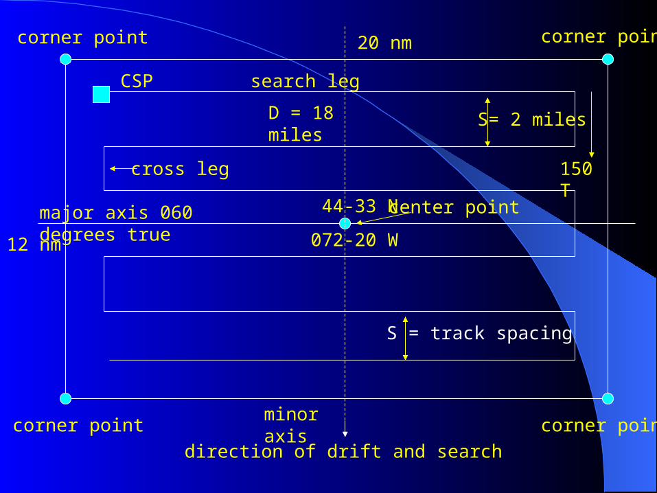
corner point
CSP
major axis 060 degrees true 44-33 N
072-20 W
center point
cross leg
search leg
D = 18 miles
S= 2 miles
corner point
corner pointcorner point
150 T
minor axis
direction of drift and search
S = track spacing
20 nm
12 nm

d
Aircraft Turn RadiusAircraft Turn Radius
At 90 knots, d = 0.5 nm
At 100 knots, d = 0.55 nm
for a standard rate turn

Search PatternsSearch Patterns
TSR = Track Line ReturnCS = Creeping Line PS = Parallel TrackSQ = Expanding SquareVS = Sector Search0 = Contour Search

Track Line Return (TSR)Track Line Return (TSR)CSP
½ track spacing
Longitude and latitude areprovided for these points

Creeping Line (CS)Creeping Line (CS)
CSPCenter point
Corner point Leg Track spacing
Majoraxis

Expanding SquareExpanding Square
CSP
11
2
2
3
3
4
4
5
5
Initialheading

Sector Search (VS)Sector Search (VS)
Datum CSP
1
c
2
c
3
c
Initial headingAll turns 120 degreesto the right

Sector Search TurnsSector Search Turns
At 100 Knots
Leg Time
1 1 min 12 sec2 36 seconds3 2 min 24 seconds
2
Turn radius = 0.55 nmfor standard rate turnat 100 knots
2
3
1
At 100 knots it takes 36 seconds to travel 1 nautical mile
It takes 40 seconds to turn 120 degrees in a standard rate turn

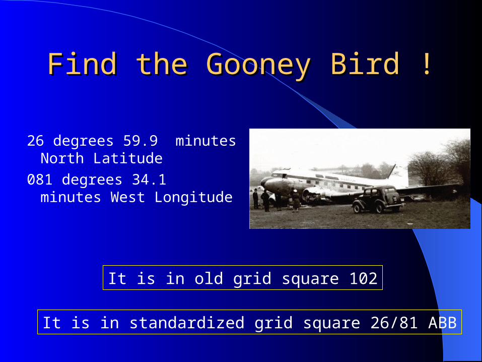
Find the Gooney Bird !Find the Gooney Bird !
26 degrees 59.9 minutes North Latitude
081 degrees 34.1 minutes West Longitude
It is in old grid square 102
It is in standardized grid square 26/81 ABB

Old Grid Old Grid Square Square
Grid Square 101
Square is 15 minutesof longitude by 15 minutes of Latitude
15.0 nautical miles
13.4 nautical miles

Standardized Lat/Long Grid SystemStandardized Lat/Long Grid System
This system does not require special numbering
Lat-long of lower right corner defines the grid
Letters are used to define sub-grids
103-00 W
103-00 W
102-00 W
102-00 W
36-00 N
37-00 N
A B
CB
C D
36/102 AA
36-30 N102-45 W
102-30 W
A B
C D
36/102 ADB
Find the Gooney Bird !Find the Gooney Bird !
26 degrees 59.9 minutes North Latitude
081 degrees 34.1 minutes West Longitude
It is in old grid square 102
It is in standardized grid square 26/81 ABB

Grid Grid Search Search
Worksheet Worksheet ExampleExampleno aircraft searching
adjacent grids

Expanding Expanding Square Square search search
worksheet worksheet exampleexample

Using the Lat/Long Function of Using the Lat/Long Function of the GPSthe GPS
Push the NAV button
Rotate the large knob untilyour position appears

Learning to Interpret the GPSLearning to Interpret the GPS
Tracking a meridian of longitude– Flying true north or south
A number greater that the desired longitude means you are west of track
A number less that the desired longitude means you are east of track

Learning to Interpret the GPSLearning to Interpret the GPS
Tracking a parallel of latitude– Flying true east or west
A number greater that the desired latitude means you are north of track
A number less that the desired latitude means you are south of track

Some ExamplesSome Examples
Desired track 081 degrees 45.0 minutes west longitude– You are headed north
GPS reads 081 45.3 GPS reads 081 45.8 GPS reads 081 45.0 GPS reads 081 43.2
– You are headed south GPS reads 081 45.3 GPS reads 081 45.0 GPS reads 081 45.8 GPS reads 081 43.2
Do you turn left or right?
Do you turn left or right?

Some ExamplesSome Examples
Desired track 26 degrees 46.0 minutes north latitude– You are headed west
GPS reads 26 46.3 GPS reads 26 45.3 GPS reads 26 45.1 GPS reads 26 46.0
– You are headed east GPS reads 26 46.3 GPS reads 26 45.3 GPS reads 26 45.0 GPS reads 26 46.1
Do you turn left or right?
Do you turn left or right?

Some ExamplesSome Examples
You are headed north along the 081 degree 45.0 meridian. You need to make a turn to the west so that you stay at least 0.5 nm from the 27 degree 0.0 minute grid square boundary. Your ground speed in 90 knots.
– You begin your turn at? 27 degrees 1.0 minutes north 26 degrees 59.5 minutes north 26 degrees 59.0 minutes north

An Actual Flight An Actual Flight
Cessna 172IAS=90 KnotsWinds east at 5 knots1000 feet AGL4 degrees W variation


SummarySummary
Search Pattern TypesSearch Pattern DefinitionsTurn RadiusGrid SquareWorksheetUsing latitude and longitude from GPS for
navigation

PracticePracticePracticePracticePracticePractice