flow and high explosives transport in a semiarid mesa in ..., and hmx (high melting explosive,...
TRANSCRIPT
www.vadosezonejournal.org · Vol. 6, No. 4, November 2007 774
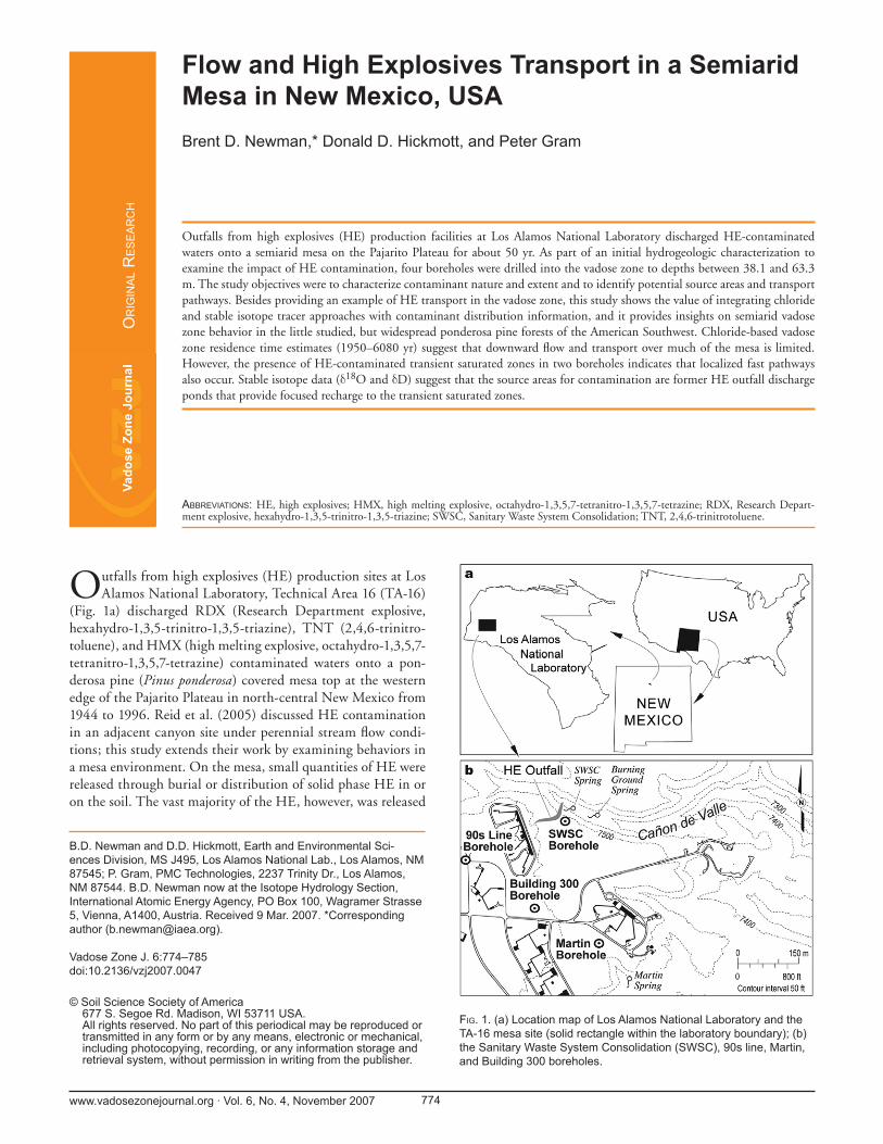
Outfalls from high explosives (HE) production sites at Los Alamos National Laboratory, Technical Area 16 (TA-16)
(Fig. 1a) discharged RDX (Research Department explosive, hexahydro-1,3,5-trinitro-1,3,5-triazine), TNT (2,4,6-trinitro-toluene), and HMX (high melting explosive, octahydro-1,3,5,7-tetranitro-1,3,5,7-tetrazine) contaminated waters onto a pon-derosa pine (Pinus ponderosa) covered mesa top at the western edge of the Pajarito Plateau in north-central New Mexico from 1944 to 1996. Reid et al. (2005) discussed HE contamination in an adjacent canyon site under perennial stream fl ow condi-tions; this study extends their work by examining behaviors in a mesa environment. On the mesa, small quantities of HE were released through burial or distribution of solid phase HE in or on the soil. The vast majority of the HE, however, was released
Flow and High Explosives Transport in a Semiarid Mesa in New Mexico, USABrent D. Newman,* Donald D. Hickmott, and Peter Gram
B.D. Newman and D.D. Hickmott, Earth and Environmental Sci-ences Division, MS J495, Los Alamos National Lab., Los Alamos, NM 87545; P. Gram, PMC Technologies, 2237 Trinity Dr., Los Alamos, NM 87544. B.D. Newman now at the Isotope Hydrology Section, International Atomic Energy Agency, PO Box 100, Wagramer Strasse 5, Vienna, A1400, Austria. Received 9 Mar. 2007. *Corresponding author ([email protected]).
Vadose Zone J. 6:774–785doi:10.2136/vzj2007.0047
© Soil Science Society of America677 S. Segoe Rd. Madison, WI 53711 USA.All rights reserved. No part of this periodical may be reproduced or transmitted in any form or by any means, electronic or mechanical, including photocopying, recording, or any information storage and retrieval system, without permission in writing from the publisher.
ABBREVIATIONS: HE, high explosives; HMX, high melting explosive, octahydro-1,3,5,7-tetranitro-1,3,5,7-tetrazine; RDX, Research Depart-ment explosive, hexahydro-1,3,5-trinitro-1,3,5-triazine; SWSC, Sanitary Waste System Consolidation; TNT, 2,4,6-trinitrotoluene.
OR
IGIN
AL R
ESEA
RC
H
Outfalls from high explosives (HE) production facilities at Los Alamos National Laboratory discharged HE-contaminated waters onto a semiarid mesa on the Pajarito Plateau for about 50 yr. As part of an initial hydrogeologic characterization to examine the impact of HE contamination, four boreholes were drilled into the vadose zone to depths between 38.1 and 63.3 m. The study objectives were to characterize contaminant nature and extent and to identify potential source areas and transport pathways. Besides providing an example of HE transport in the vadose zone, this study shows the value of integrating chloride and stable isotope tracer approaches with contaminant distribution information, and it provides insights on semiarid vadose zone behavior in the little studied, but widespread ponderosa pine forests of the American Southwest. Chloride-based vadose zone residence time estimates (1950–6080 yr) suggest that downward fl ow and transport over much of the mesa is limited. However, the presence of HE-contaminated transient saturated zones in two boreholes indicates that localized fast pathways also occur. Stable isotope data (δ18O and δD) suggest that the source areas for contamination are former HE outfall discharge ponds that provide focused recharge to the transient saturated zones.
FIG. 1. (a) Location map of Los Alamos National Laboratory and the TA-16 mesa site (solid rectangle within the laboratory boundary); (b) the Sanitary Waste System Consolidation (SWSC), 90s line, Martin, and Building 300 boreholes.

www.vadosezonejournal.org · Vol. 6, No. 4, November 2007 775
through wastewater discharges that distributed HE through surface runoff or into a series of unlined wastewater ponds. Individual ponds covered less than 900 m2 in surface area and were less than 2 m deep. Historic discharges from individual wastewater outfalls were often greater than 100 m3 yr−1, and some outfalls operated for about 50 yr; however, once wastewa-ter releases were discontinued, the ponds were frequently dry. Most of ponds have since been removed as part of site cleanup efforts. HE concentrations in surface soils have ranged to more than 20% w/w, and HE in surface waters have ranged to more than 800 μg L−1 (Los Alamos National Laboratory, 1998). As part of an initial investigation of HE contamination, four boreholes were drilled to depths between 38.1 and 63.3 m to characterize the TA-16 mesa vadose zone hydrologic properties and defi ne the nature and extent of contamination in an area with multiple HE release locations and types. Before drilling, little was known about the vadose zone stratigraphy, hydrologic properties, and fl uxes in this part of the laboratory, or what the contaminant distributions (i.e., the nature and extent of HE) might be. The vadose zone at TA-16 is approximately 228 m thick, so this study did not investigate the entire thickness of the vadose zone. It is, however, one of the fi rst hydrogeologic and contaminant characterization efforts on the western part of Los Alamos National Laboratory and the Pajarito Plateau.
The main objective of this paper is to document how a combined approach using multiple environmental tracers along with characterization of contaminant distribution, hydrau-lic properties, and hydrology was used to evaluate the nature and extent of HE contamination and the controls on fl ow in a complex vadose zone environment. Through this com-bined approach, we have developed a conceptual model that describes factors that are important for controlling water fl ow and HE transport in the mesa. As an additional benefi t, we were able to quantify downward fl uxes within a southwestern U.S. ponderosa pine ecosystem, the importance of which is discussed below.
High explosives are contaminants of concern in many countries, and releases can occur from HE production and machining facilities, disposal facilities, and fi ring sites, and at locations where large quantities of munitions have been stored in uncontrolled environments. The different varieties of HE have a wide range of solubilities, transport characteristics, and degradation properties and can contaminate the vadose zone as well as groundwater (Beller et al., 2004; DiGnazio et al., 1998; Fryar et al., 2000; Layton et al., 1987; Pennington and Brannon, 2002; Reid et al., 2005; Spalding and Fulton, 1988). Some types of HE have characteristics that make them of greater concern when released into the environment. One of the more problematic varieties is RDX, which was the most commonly processed type of HE at the TA-16 site (Los Alamos National Laboratory, 1998). It can behave conservatively and thus be quite mobile, especially in oxidizing, low carbon envi-ronments typical of many vadose and groundwater systems (Layton et al., 1987; Pennington and Brannon, 2002; Reid et al., 2005; Spalding and Fulton, 1988). Under these conditions, RDX degradation appears to be slow, and sorption is minimal (Layton et al., 1987; Reid et al., 2005; Spalding and Fulton, 1988). In addition, the relatively high solubility of RDX (42–
60 mg L−1; Card and Autenrieth, 1998; Layton et al., 1987) and low drinking water health advisory of 2 μg L−1 (USEPA, 2000) create a combination where human health risks can be an issue. Studies that describe HE contamination and transport in semiarid vadose zones are quite limited (e.g., Fryar et al., 2000); this study broadens the understanding of HE transport within thick, bedrock-dominated vadose zone environments.
The study area is covered by ponderosa pine forest, and thus, the results reported here also apply to understanding hydrological behavior in these important ecosystems. Few stud-ies have quantifi ed vadose zone fl uxes in ponderosa pine ecosys-tems in the southwestern United States (Newman et al., 1997; Sandvig and Phillips, 2006). However, ponderosa pine is the dominant tree species on more than 16 million ha in North America (McPherson, 1997). In addition, ponderosa pines occupy important landscape positions in terms of groundwater recharge in the southwestern United States. Using the terminol-ogy of Duffy (2004) and Wilson and Guan (2004), ponderosa pine forests are commonly associated with the mountain block and front and the upper piedmont, all of which can be associ-ated with higher recharge rates than generally occur within the lower parts of semiarid basins. Thus, quantifying hydrologic behavior in ponderosa pine environments helps defi ne expected distributions of fl uxes for these ecosystems, which can aid in using vegetation as an indicator for estimating basin-scale recharge (see discussion in Newman et al., 2006; Sandvig and Phillips, 2006; Walvoord and Phillips, 2004).
Site DescriptionThe climate at TA-16 is semiarid, with annual precipita-
tion rates about 500 mm yr−1 (Bowen, 1990). The mesa site is at an elevation of approximately 2316 m and is underlain by the uppermost cooling units of the Tshirege (upper) member of the Bandelier Tuff, which was erupted 1.22 million years ago (Izett and Obradovich, 1994). The Bandelier Tuff consists of two basal Plinian fallout pumice beds with overlying ash fl ow deposits (Broxton and Reneau, 1995; Broxton and Vaniman, 2005; Crowe et al., 1978). These ash fl ow deposits are char-acterized by varying degrees of welding and devitrifi cation. The welding and devitrifi cation characteristics have a major infl uence on the porosity and permeability of the vadose zone. Internal morphology ranges from coarse bedded and surgelike to massive devitrifi ed ignimbrite. Surge beds (unwelded fl ows) are discontinuous features that form mainly through collapse of vertical eruption columns (Fisher and Schmincke, 1984). They can be important hydrologically (as in this case) because they form relatively high conductivity units that can lie directly adja-cent to much lower conductivity tuff units. The Bandelier Tuff shows signifi cant variation in both degree of welding and degree of devitrifi cation between individual units. These reversals are due to brief cooling intervals that separated the emplacement of individual fl ow units. The subunits underlying the TA-16 mesa are among the most heterogeneous within the Tshirege member on the Pajarito Plateau. Densely welded tuff, non-welded tuff, and surge bed material are present within 61 m of the surface at TA-16 (Broxton and Reneau, 1995; Lewis et al., 2002; Rogers, 1995).

www.vadosezonejournal.org · Vol. 6, No. 4, November 2007 776
Materials and MethodsBorehole Drilling
In 1997 four hollow stem auger boreholes were drilled and continuously sampled using a split spoon. The four locations span the width of the TA-16 mesa (Fig. 1b). The boreholes (90s line, Building 300, Sanitary Waste System Consolidation [SWSC], and Martin boreholes) were located in the vicinity of known or potential HE source areas. The 90s line borehole was located near what was called the 90s line HE production facility, which discharged HE-contaminated waters into a series of sumps, ditches, and a lagoon known as the 90s line pond. The Building 300 borehole was located near another HE facil-ity called Building 300. This borehole was also located in a geophysical (self-potential) anomaly (Los Alamos National Laboratory, 1998). The SWSC borehole was located approxi-mately 200 m east of a major HE outfall. The Martin borehole was also located in a geophysical anomaly (self-potential and resistivity) near the head of Martin Canyon (which contains an HE-contaminated spring; Los Alamos National Laboratory, 1998). In addition, the Martin borehole is located approxi-mately 900 m east of a series of former HE wastewater lagoons and outfalls. The Building 300 and SWSC holes were drilled to 57.6 and 63.3 m, respectively. The 90s line and Martin holes were drilled to 50.3 and 38.1 m, respectively, and drilling was stopped when fl owing water was encountered.
Core AnalysisEach hole was continuously cored, and stratigraphic
descriptions were made of the various tuff units encountered. Descriptions included secondary crystallization, welding, pum-ice size, ferromagnesian mineral and quartz abundances, pres-ence of fractures, and bulk rock and fracture alteration (Lewis et al., 2002; Los Alamos National Laboratory, 1998).
In addition to the lithologic descriptions, moisture-pro-tected core samples were collected for hydrologic property characterization and for pore water chloride and stable isotope analyses. Analyses of hydrologic properties were conducted by Daniel B. Stephens & Associates (1999) and included gravimet-ric water content, bulk density, saturated hydraulic conductiv-ity, moisture characteristic curve information, and calculated porosity.
Pore water chloride and stable isotope samples were col-lected approximately every 3 m. To preserve in situ water content, samples were placed in glass septum jars for chloride analyses and heat-sealed, aluminized bags for stable isotope analyses. Pore water chloride and stable isotope values were determined using methods described in Newman et al. (1997). Gravimetric water content analyses were performed before con-ducting the chloride leaching analyses according to Gardner (1986). Chloride concentrations were measured using ion chro-matography with an analytical precision of ± 5%. The chloride mass balance approach (Allison et al., 1985; Anderholm, 1994; Newman et al., 1997; Phillips, 1994; Scanlon, 2000) was used to calculate vadose zone downward (residual) fl uxes according to
R = (Clp × P)/Cla [1]
where R is the residual fl ux, Clp is the average annual chloride concentration in precipitation (g m−3), P is the average annual precipitation rate (m yr−1), and Cla is the average pore water chloride concentration (g m−3) in the borehole. Vadose zone residence times were also be estimated using the chloride mass balance method:
A = Clcum/(Clp × P) [2]
where A is the vadose zone residence time down to a certain depth of interest (yr), and Clcum is the cumulative chloride con-tent from the ground surface to the depth of interest (g m−2). For this study, we used values of 0.29 g m−3 for Clp (Anderholm, 1994) and 0.5 m yr−1 for P (Bowen, 1990).
Stable isotope measurements (δ18O and δD) of pore waters have been used effectively as indicators of water source and evaporation in hydrological studies (Allison et al., 1983; Barnes and Allison, 1983; Barnes and Allison, 1984; DePaolo et al., 2004; Machavaram et al., 2006; Newman et al., 1997). Stable isotope analyses were conducted at the New Mexico Tech stable isotope laboratory using the distillation method of Shurbaji et al. (1995) and the extraction methods of Socki et al. (1992) and Kendall and Coplen (1985). Analytical precisions for the δ18O and δD analyses were 0.2 and 2‰, respectively. The isotope values are reported based on the V–SMOW (Vienna–Standard Mean Ocean Water) standard.
Core was also analyzed for HE every 1.5 m using an immu-noassay screening method (DTECH, Strategic Diagnostics, Inc., Newark, DE), supplemented with laboratory HE analyses using EPA SW-846, Method 8330 (USEPA, 1996) of two to four grab samples from each borehole. The detection limits were approximately 0.5 mg kg−1 and 0.1 μg kg−1 for the DTECH and SW-846 methods, respectively (Los Alamos National Laboratory, 1998). Groundwater samples from the 90s line and Martin boreholes were analyzed using both DTECH and EPA SW-846 methods whenever water fl owed into the borehole.
Borehole Monitoring
The four boreholes were monitored for volumetric water content using neutron attenuation, and the probe was cali-brated to local soils and Bandelier Tuff. Monitoring was done quarterly from 1999 through 2000. In addition, the 90s line and Martin holes were monitored for groundwater levels. The Martin borehole groundwater was sampled for stable isotopes and HE whenever enough water fl owed into the borehole. The 90s line hole has not fl owed since the initial sampling (probably because of a multiyear drought).
ResultsStratigraphy and Lithology
The stratigraphic units encountered in the boreholes include shallow soils, alluvium, the El Cajete pumice, and the upper units of the Tshirege member of the Bandelier Tuff (Fig. 2). The deepest Tshirege subunit encountered was the partially to moderately welded subunit Qbt3. A surge bed exists between subunit Qbt3 and the overlying subunit Qbt3t. Subunit Qbt3t is commonly very densely welded at the top and bottom con-tacts. Unit Qbt4 is the uppermost Tshirege subunit and contains

www.vadosezonejournal.org · Vol. 6, No. 4, November 2007 777
a basal poorly welded interval, a non- to poorly welded middle, and an upper densely welded interval. The unit Qbt4 intervals are typically separated by surge beds. Surge beds can also be present within subunits Qbt3 and Qbt3t. Details of the stratigraphic units and their lithologic and mineralogical charac-teristics are discussed in Lewis et al. (2002).
Hydrologic Properties
A summary of the hydrologic properties based on geologic unit is shown in Table 1. The hydrologic data show a wide range in bulk den-sities, porosities, and saturated hydraulic conductivities that are related to the degree of welding. Surge beds have the highest poros-ities and saturated con-ductivities and the low-est bulk densities. Partly welded tuff units have intermediate values of hydrologic properties, and the densely welded units have the high-est bulk densities, and lowest porosities and hydraulic conductiv-ities. However, the lab-oratory analyses essen-tially measure matrix conductivities, and core and outcrop observa-tions in the area suggest that fractures are com-mon in the welded units (Lewis et al., 2002), and high-permeability deformation bands, which can also promote preferential water movement in the vadose zone, are present in the less-welded units (Wilson et al., 2003; Wilson et al., 2006). Thus, even though the matrix conductivities in the densely welded units are low, preferential fl ow-path conductivities can be high.
Water Content Results
Example volumetric water content results for the boreholes are shown in Fig. 2a through 2d. In general, there was little variation in water content with time (typically less than 2%, except at the shallowest depths). Profi les such as these refl ect the semiarid climate and the low deep percolation rates observed for many mesa locations on the Pajarito Plateau (Birdsell et al., 2005; Kwicklis et al., 2005). Volumetric water contents range from 3 to 23%, and average water contents range from 6% to
FIG. 2. Volumetric water contents (from neutron probe) and stratigraphy from (a) the 90s line, (b) Building 300, (c) Martin, and (d) Sanitary Waste System Consolidation (SWSC) boreholes. Qal is Quaternary alluvium, the el Cajete is a pumice bed, and Qbt4 through Qbt3 are subunits of the Quaternary Tshirege member of the Bandelier Tuff.

www.vadosezonejournal.org · Vol. 6, No. 4, November 2007 778
10% in the four holes. Changes in water content with depth appear to be associated with changes in stratigraphy and/or degree of welding. During drilling, fl owing water was encoun-tered at approximately 39 m in the 90s line borehole and 24 m in the Martin borehole (Fig. 2a and 2c). These zones cor-respond to intervals of fractured, welded tuff. After the water level stabilized, the holes were bailed dry. No additional fl ow was observed in the 90s line borehole. The Martin borehole also remained dry most of the time. However, fi ve separate fl ow events were observed in the Martin borehole over the next 5 yr. These events were in response to high snowmelt and rain-fall periods. In these groundwater zones, volumetric water con-tents were about 18%. The calculated porosities for the welded intervals that contain the wet zones range from 16 to 20%, suggesting that the groundwater zones were at or near satura-tion for the study period. Based on the ephemeral fl ow, we will hereafter refer to the groundwater producing depths as transient saturated zones.
High Explosives Results
High explosives analyses of the SWSC and Building 300 boreholes did not show any detectible HE. There were no detec-tions of HE from the 90s line and Martin boreholes except in the groundwater near the bottom of the holes. In 1997 ground-water from the 90s line borehole contained HE in the form of 2,4-dinitrotoluene (4.03 μg L−1), HMX (21 μg L−1), RDX (281 μg L−1), and TNT (1.27 μg L−1). The 1997 sample was collected a few days after drilling was completed, and this was the only time the borehole produced water. The Martin bore-hole fl owed for short periods on fi ve different occasions from 1997 through 2001. High explosives were detected in the form of amino-2,6-dinitrotoluene (1–2.5 μg L−1), HMX (2.3–14 μg L−1), and RDX (15.2–120 μg L−1). There was no clear trend in the Martin borehole concentrations with time, although the 2000 and 2001 fl ow events had substantially lower concentra-tions for all types of HE than had been observed previously.
Chloride Results
Pore water chloride profi les for the 90s line, Martin, SWSC, and Building 300 boreholes are shown in Fig. 3. Concentrations range from 11 to 1952 mg L−1. Like the water content data, changes in chloride concentrations appear to be associated with changes in stratigraphy and degree of welding. Vadose zone residence times are 2240 yr for the 90s line borehole, 6080 yr
for the Martin borehole, 1950 yr for the SWSC borehole, and 2300 yr for the Building 300 borehole. Residence times are based on cumulative chloride from the sur-face to the top of the transient saturated zones for the 90s line and Martin boreholes, and to the bottom of the SWSC and Building 300 boreholes. These long residence times suggest that there has been little to no downward recharge at the borehole locations for nearly 2000 yr or longer.
Chloride-based residual fl uxes are similar for the four boreholes (1.3 mm yr−1 for the 90s line borehole, 1.3 mm yr−1 for the Martin borehole, 1.4 mm yr−1 for the SWSC borehole, and 1.2 mm yr−1 for the Building 300 borehole). Walvoord et al. (2002a, 2002b) showed that in areas dominated by upward fl uxes, the chloride
mass balance method will erroneously yield small positive val-ues (i.e., the one-dimensional downward fl ow assumption of the chloride method is not always consistent with actual fi eld con-ditions, and therefore, an overestimation of the downward fl ux can occur). However, as Sandvig and Phillips (2006) pointed out, gradients in ponderosa pine environments appear to be largely downward; therefore, the fl uxes reported here should be reasonably representative. At worst, they could be consid-ered maximum estimates. It is diffi cult to quantify uncertainty accurately in the chloride mass balance results because of, for example, the problem of defi ning how well the chloride and precipitation input rates used in Eq. [1] and [2] represent the real values over the last few thousand years or more.
Another aspect to the chloride fl ux results from this study aids in understanding fl ow in the mesa: the downward fl ux of water in the vadose zone appears to be relatively constant with
TABLE 1. Hydrologic properties summary for the uppermost subunits of the Tshirege member, Bandelier Tuff at TA-16.
Unit† Borehole Depth θv ρb Porosity Ks Weldingm % g cm−3 % cm s−1
4 Building 300 3.2 6.7 1.73 35 1.4E-05 partial4 Building 300 5.8 3.9 1.97 26 1.2E-06 partial4 Building 300 9.4 2.4 1.3 51 3.8E-03 surge3T SWSC‡ 21.5 7.8 2.13 20 1.7E-08 dense3T 90s line 27.4 7.2 2.17 18 2.0E-08 dense3T SWSC 27.1 4.6 2.21 17 9.8E-09 dense3T SWSC 30.6 7.2 2.16 18 2.8E-08 dense3 SWSC 36.7 15.4 1.42 47 5.0E-04 surge3 SWSC 39.5 5.2 1.71 36 5.8E-05 poor
† The stratigraphic unit within the Tshirege member of the Bandelier Tuff as described by Lewis et al. (2002).
‡ SWSC, Sanitary Waste System Consolidation borehole.
FIG. 3. Pore water chloride profi les for the 90s line, Martin, Sanitary Waste System Consolidation (SWSC), and Building 300 boreholes.
www.vadosezonejournal.org · Vol. 6, No. 4, November 2007 779
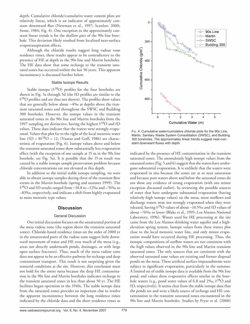
depth. Cumulative chloride/cumulative water content plots are relatively linear, which is an indicator of approximately con-stant downward fl ux (Newman et al., 1997; Scanlon, 2000; Stone, 1984; Fig. 4). One exception to the approximately con-stant linear trends is for the shallow part of the 90s line bore-hole. This deviation likely resulted from localized near-surface evapotranspiration effects.
Although the chloride results suggest long vadose zone residence times, these results appear to be contradictory to the presence of HE at depth in the 90s line and Martin boreholes. The HE data show that some recharge to the transient satu-rated zones has occurred within the last 50 years. This apparent inconsistency is discussed further below.
Stable Isotope Results
Stable isotope (δ18O) profi les for the four boreholes are shown in Fig. 5a through 5d (the δD profi les are similar to the δ18O profi les and are thus not shown). The profi les show values that are generally below about −4‰ at depths above the tran-sient saturated zones and throughout the SWSC and Building 300 boreholes. However, the isotope values in the transient saturated zones in the 90s line and Martin boreholes from the 1997 sampling are distinctive, having the highest δ18O and δD values. These data indicate that the waters were strongly evapo-rated. Values that plot far to the right of the local meteoric water line (δD = 8δ18O + 12; (Vuataz and Goff, 1986) are charac-teristic of evaporation (Fig. 6). Isotope values above and below the transient saturated zones show substantially less evaporation effect (with the exception of one sample at 15 m in the 90s line borehole; see Fig. 5a). It is possible that the 15-m result was caused by a stable isotope sample preservation problem because chloride concentrations are not elevated at this depth.
In addition to the initial stable isotope sampling, we were able to obtain isotope samples during three of the transient fl ow events in the Martin borehole (spring and summer 1999). The δ18O and δD results ranged from −10.8 to –12‰ and –76‰ to –83‰, respectively, and indicate a shift from highly evaporated to more meteoric type values.
DiscussionGeneral Discussion
Our initial discussion focuses on the unsaturated portion of the mesa vadose zone (the region above the transient saturated zones). Chloride-based residence times on the order of 2000 yr in the unsaturated parts of the vadose zone suggest little down-ward movement of water and HE over much of the mesa (e.g., areas not directly underneath ponds, drainages, or with large open surface fractures). Thus, much of the mesa vadose zone does not appear to be an effective pathway for recharge and deep contaminant transport. This result is not surprising given the semiarid conditions at the site. However, this conclusion must not hold for the entire mesa because the deep HE contamina-tion in the 90s line and Martin boreholes indicates recharge to the transient saturated zones in less than about 50 yr. The HE facilities began operation in the 1940s. The stable isotope data from the saturated zones provides an important clue to resolve the apparent inconsistency between the long residence times indicated by the chloride data and the short residence times as
indicated by the presence of HE contamination in the transient saturated zones. The anomalously high isotope values from the saturated zones (Fig. 5 and 6) suggest that the waters have under-gone substantial evaporation. It is unlikely that the waters were evaporated in situ because the zones are at or near saturation and because pore waters above and below the saturated zones do not show any evidence of strong evaporation (with one minor exception discussed earlier). In reviewing the possible sources of water that have undergone substantial evaporation (having relatively high isotope values) on the mesa, most outfl ows and discharge waters were not strongly evaporated when they were released, having δ18O values of about −10.5‰ and δD values of about −76‰ or lower (Blake et al., 1995; Los Alamos National Laboratory, 1996). Waters used for HE processing at the site came from the Los Alamos drinking water aquifer and a high-elevation spring system. Isotope values from these waters plot close to the local meteoric water line, and only minor evapo-ration would have occurred during HE processing. Thus, the isotopic compositions of outfl ow waters are not consistent with the high values observed in the 90s line and Martin transient saturated zones. The only sources that are consistent with the observed saturated zone values are existing and former disposal ponds on the mesa. These artifi cial surface impoundments were subject to signifi cant evaporation, particularly in the summer. A limited set of stable isotope data is available from the 90s line pond, and values show evaporative effects similar to the bore-hole waters (e.g., pond water values of 6.8 and 2‰, δ18O and δD, respectively). It seems clear from the stable isotope data that the ponds are and were a likely source of recharge and HE con-tamination to the transient saturated zones encountered in the 90s line and Martin boreholes. Studies by Fryar et al. (2000)
FIG. 4. Cumulative water/cumulative chloride plots for the 90s Line, Martin, Sanitary Waste System Consolidation (SWSC), and Building 300 boreholes. The approximately linear trends suggest near-con-stant downward fl uxes with depth.

www.vadosezonejournal.org · Vol. 6, No. 4, November 2007 780
and Machavaram et al. (2006) have also shown that elevated isotope values such as those observed here are consistent with pond- or playa-type source areas. Thus, as Scanlon and Goldsmith (1997) pointed out, even though there may be substantial evaporation from ponded waters, this does not preclude recharge from happen-ing at those locations. The mesa pond sources have similar chloride and HE concentrations to the transient satu-rated zones (Los Alamos National Laboratory, 1996), and both of the boreholes were drilled in the vicinity (within 300 m) of disposal ponds, also supporting the interpretation of ponded water sources. Another aspect that suggests that the ponds were subject to evaporation is that chloride concentrations in the transient saturated zones are relatively high (Fig. 3), yet the sources of water for HE process-ing at the site were only about 2 mg L−1 (Blake et al., 1995; Los Alamos National Laboratory, 2005).
Discharge ponds, lagoons, cesspools, or leaching pits were com-monly used for HE disposal in the past. Studies in California, Indiana, Nebraska, and Texas (Beller et al., 2004; DiGnazio et al., 1998; Fryar et al., 2000; Spalding and Fulton, 1988) all indicate that ponded water HE disposal has resulted in groundwater contamination. In addition to their importance for HE disposal, small artifi cial ponds are also sig-nifi cant hydrological features in other areas (especially in the United States). Smith et al. (2002) found that small artifi cial water bodies account for approximately 20% of the standing
water area across the United States and noted that their impact on hydrological and other processes is apparently large in pro-portion to their area. Thus, artifi cial ponds like the ones stud-ied here represent signifi cant anthropogenic alterations to the landscape, and this study contributes to our understanding of the impacts these features have on hydrological systems.
FIG. 5. Stable isotope (δ18O) and volumetric water content profi les at (a) the 90s line, (b) Building 300, (c) Martin, and (d) Sanitary Waste System Consolidation (SWSC) boreholes.

www.vadosezonejournal.org · Vol. 6, No. 4, November 2007 781
There must also be a lateral component to subsurface fl ow in the mesa since the boreholes were not drilled directly adja-cent to any of the ponds. The presence of HE in the transient saturated zones and absence of HE above and below these zones, stable isotope and water content distributions in the boreholes, the superposition of high-conductivity tuff units over low con-ductivity units, and observed subhorizontal fracturing in core samples from the transient saturated zones are additional evi-dence for a lateral fl ow component.
The timing of fl ows into the Martin borehole and the observed shift to negative isotope values suggest that the tran-sient nature of fl ow and transport is seasonally or event con-trolled (although fl ow must have been more regular during the period of active discharge into the ponds). All of the recent fl ow events in the borehole were associated with relatively large snowmelt or precipitation events. It is likely that even though the pond waters have high isotope values (from evaporation) during part of the year, values shift to more meteoric type val-ues during the winter and, in the past, during high-volume wastewater discharges. Thus, it is not surprising that the iso-tope values in the borehole vary over time. It is also likely that there is some vadose zone mixing between older contaminated pond waters and newer recharge as indicated by the response to snowmelt and precipitation events and the apparent dilution of HE concentrations in more recent samples.
Conceptual Model
Birdsell et al. (2005) presented a series of conceptual mod-els that describe percolation and recharge conditions for can-yons and mesas on the Pajarito Plateau. Our study describes ele-ments that fall within their mountain front and disturbed mesa conceptual models. Specifi cally, Birdsell et al. (2005) noted that the combination of higher precipitation rates and fractures in densely welded tuffs that occur in mountain front mesas (such as at TA-16) can enhance recharge, especially compared with mesas at lower elevations. They also described how disturbed conditions such as artifi cial ponds can substantially alter sub-surface fl ow in mesas compared with natural conditions. From the characterization data collected in this study, we extend the work of Birdsell et al. (2005) through the development of a detailed conceptual model of the conditions at the TA-16 mesa site (Fig. 7). This new model summarizes what appears to con-trol “rapid” fl ow and transport to depths of over 30 m in parts of the mesa, while other parts of the mesa have only slow down-ward fl ow. The model highlights the importance of disturbance (i.e., ponding) on vadose zone behavior in this heterogeneous system. It also shows how important it can be to understand the relative roles of matrix and preferential pathways in controlling fl ow and transport in the vadose zone. These results are con-sistent with studies in the semiarid, subhumid High Plains of the United States that clearly show the importance of ponding in creating strong contrasts in downward fl uxes and recharge rates between topographically low areas (e.g., ponds and playas) and interpond areas (Fryar et al., 2001; McMahon et al., 2006; Scanlon and Goldsmith, 1997). These studies also noted that preferential fl ow through fractures and cracks below ponded areas also play an important role in the recharge process.
In the TA-16 mesa conceptual model, pond water evap-orates and percolates into the underlying tuff, where it fl ows
laterally on encountering welded (less-permeable) tuff units or subhorizontal fractures within these units. Lateral fl ow is pro-moted because of the superposition of relatively high hydraulic conductivity units (e.g., surge beds and poorly welded tuffs) over units with low matrix hydraulic conductivities (e.g., strongly welded tuffs; see Table 1). We hypothesize that the fl ow paths may have a stair-stepped appearance as indicated in Fig. 7 because the geology and hydrologic properties data indi-cate multiple zones of high/low conductivity transitions.
Although the four boreholes provided useful information about contaminant nature and extent, they do not completely constrain the extent of HE contamination. Additional boreholes could help establish a better understanding of the distribution of HE in the vadose zone. It is clear that downward fl ow and transport from the ponds has occurred at rapid rates, especially when compared to chloride mass balance results from interpond areas. In 50 years or less, HE has been transported at least 40 m downward and at least 900 m laterally within the mesa (based on the distance from the Martin borehole to the nearest pond). It is quite likely that the extent of contamination is larger than what has been determined here. An important consideration for future work is whether HE from pond source areas has reached the deep aquifer system, 228 m below the mesa top. Assuming a 50-yr disposal period, minimum transport velocities for at least some portion of the water down to the transient saturated zones are on the order of 0.5 to 0.8 m yr−1, and actual velocities could be substantially higher. The shift from isotopically heavy to light compositions in the saturated zone over an approx-
FIG. 6. Local meteoric water line plot of the Martin and 90s line bore-hole data. Values that plot far to the right of the line indicate substantial evaporation. Values that plot on or near the line indicate minor to no evaporation. Data include analyses from pore water samples extracted from cores and bailed saturated zone samples (1999 data).

www.vadosezonejournal.org · Vol. 6, No. 4, November 2007 782
imately 2-yr period suggests transport velocities are likely much higher than the estimated minimum range of 0.5 to 0.8 m yr−1. Unfortunately, we do not know the age of the light water that entered the saturated zone, which prevents making an accu-rate estimate of an isotope-based velocity. In other words, the light water entering the saturated zone may have been pre-event water that has been stored in the vadose zone for some unknown amount of time before its mobilization to the borehole. It is also diffi cult to estimate Darcy fl uxes below the ponds given the lack of water content data directly below the ponds and because of the complication of mixed matrix and preferential fl ow. Future drilling within former pond areas should help in this regard.
An alternative conceptual model that was considered for the site is that signifi cant fracture fl ow in the nondisturbed areas where the boreholes were drilled would mean that the fl uxes in these areas are much higher than suggested by the chloride mass balance approach. Under such a scenario, signifi cant recharge to the transient saturated zones could be occurring in the vicinity of the boreholes. The chloride mass balance method is relatively insensitive to preferential fl ow because the large con-centrations of chloride that are stored in the matrix can mask potentially low concentrations that would occur in a fracture or other preferential fl ow path because a bulk sample of rock or soil is analyzed (see, e.g., Newman et al., 1998). Although we cannot totally reject this alternative conceptual model, we fi nd it to be unlikely based on four lines of evidence. First, during 2 yr of quarterly water content monitoring, we never observed any local increases in water content that would suggest that fracture fl ow was occurring near the boreholes. This includes the 1999 periods when saturated zone fl ow events in the Martin borehole were observed. Second, as mentioned earlier, HE and chloride concentrations in the transient saturated zones were similar
to those measured in the ponds. Signifi cant fracture fl ow from nondisturbed areas would have diluted these concentrations unless there were substantial contaminant invento-ries in the vadose zone in the nondisturbed areas (which does not appear to be the case). Third, studies by Soll and Birdsell (1998) and Robinson et al. (2005) suggest that under the low water content conditions (above the saturated zones) observed here, even when fractures are present, fl ow is dominantly through the tuff matrix. These studies did not examine densely welded tuffs; however, at TA-16, these units occur between nonwelded to moderately welded tuff units where matrix fl ow should be dominant. It is also worth not-ing that nonwelded to moderately welded tuff units comprise most of the mesa vadose zone at the study area. Fourth, if fracture fl ow was important from nondisturbed areas around the boreholes, it is unlikely that we would have observed the high isotope values in the transient saturated zones. Fracture fl ow prob-ably would not show a signifi cant evaporative isotope signature here because fl ow would quickly leave the near-surface soil zone; there-fore, little to no evaporation would occur.
Newman et al. (1998), for example, showed that preferential fl ow in the soil zone at a ponderosa pine site only a few kilome-ters from this study area had little to no evaporative enrichment. Thus, the high isotope values are inconsistent with signifi cant fracture fl ow in the vicinity of the boreholes. We do acknowl-edge that under ponded conditions, fracture fl ow is likely to be important, which is refl ected in the conceptual model shown in Fig. 7. We also noted areas on the mesa where open fractures extend to the mesa surface, and run-on into these fractures could provide recharge to saturated zones within the mesa. These fractures exist west of the study area, and recharge from them could explain in part the shift from the high to low iso-tope values that occurred in the Martin borehole saturated zone in 1999. However, this process would not invalidate using the chloride mass balance approach in this case because recharge from these particular fractures would enter the saturated zone west of the study area.
Fluxes beneath Ponderosa Pine Forests
One of the other benefi ts of this study was that we were able to investigate vadose zone fl uxes beneath a ponderosa pine forest. As mentioned earlier, these are widespread ecosystems in the southwestern United States that occupy hydrologically important landscape positions. Thus, ponderosa pine ecosys-tems have potential for use as an indicator of a specifi c range of downward fl uxes that can be used to support basin-scale esti-mates of diffuse recharge (Kwicklis et al., 2005; Newman et al., 2006; Sandvig and Phillips, 2006; Walvoord and Phillips, 2004). In an investigation of arid and semiarid ecosystems along an elevationalF gradient in central New Mexico, Sandvig and Phillips (2006) found that downward fl uxes beneath ponderosa pines were the highest of the four ecosystems studied. Using the
FIG. 7. Generalized conceptual model of the TA-16 mesa vadose zone (not to scale) showing the two dominant fl ow domains. Under areas affected by surface ponding (repre-sented by fl ow paths to the left of the borehole) downward and lateral fl uxes are substantial. These fl ow paths transport high explosives (HE) and, combined with the hydraulic prop-erties of the tuff units, cause the development of transient saturated zones at depth. Under areas not affected by surface ponding (represented by fl ow paths to the right of the bore-hole), low downward fl uxes predominate. This low fl ux domain is present over most of the TA-16 mesa.

www.vadosezonejournal.org · Vol. 6, No. 4, November 2007 783
chloride mass balance method, they estimated a downward fl ux beneath ponderosa pines of about 2.3 mm yr−1, and residence times of 300 to 3600 yr (for 4.5-m deep profi les). Their fl ux estimate is similar to the 1.3 mm yr−1 average estimated here. Newman et al. (1997) used chloride mass balance in a pon-derosa pine forest at another mesa site on the Pajarito Plateau and obtained a range of downward fl uxes from 0.1 to 2 mm yr−1 through the soil zone (<1.5 m deep). They attributed the low fl uxes to the presence of a thick clay horizon. Sandvig and Phillips (2006) also noted that clay horizons may be a factor in controlling fl uxes below ponderosa pines in their study (i.e., the site with the 3600-yr residence time). Clay horizons are present in the soil zone at our study site and thus likely play a role in controlling fl uxes to the deeper system.
It is interesting to note that the previous studies were con-ducted using profi les that were less than 5 m deep, yet, with the exception of the lower values from the Newman et al. (1997) study, fl uxes are similar to those reported here, which were determined from much deeper profi les (38–63 m). The linearity of cumulative water versus cumulative chloride plots found here (Fig. 4) and by Sandvig and Phillips (2006) sug-gests that fl uxes are relatively constant with depth and that shal-low boreholes in interdrainage locations that penetrate bedrock (e.g., <10 m) may be adequate for determination of diffuse type fl uxes in these ecosystems. However, shallow boreholes may miss features such as transient saturated zones that are driven by focused fl ow processes.
Collectively, the residual fl ux estimates for southwestern U.S. ponderosa pine ecosystems from Newman et al. (1997), Sandvig and Phillips (2006), and this study range from 0.1 to 2.3 mm yr−1. Although additional vadose zone studies in southwestern ponderosa pine ecosystems are clearly needed, the range can be considered an initial benchmark for the type of diffuse fl uxes that can be expected in these ecosystems. Scanlon et al. (2006) compiled fl ux estimates from chloride mass bal-ance studies in arid and semiarid regions worldwide and found a range of 0.2 to 35 mm yr−1. Although Sandvig and Phillips (2006) found that ponderosa ecosystems had the highest fl uxes of all the ecosystems that they studied, it is curious that the ponderosa pine fl uxes are at the lower end of the Scanlon et al. (2006) range, especially because ponderosa ecosystems tend to exist in the wetter parts of semiarid climate zones. This obser-vation suggests that the upper bound of the range reported here (2.3 mm yr−1) may be too low or that focused recharge is enhanced in these systems. In other words, additional pre-cipitation (not lost through evapotranspiration) in ponderosa ecosystems may be routed through focused recharge pathways instead of increasing diffuse recharge rates. Ponderosa pines tend to occupy mountain block, mountain front, and upper piedmont positions in southwestern landscapes. The canyons, arroyos, faults, and fractures that are prevalent in these land-scape positions act as features where high focused recharge rates occur (Duffy, 2004; Scanlon et al., 2006; Wilson and Guan, 2004). Thus, ponderosa pines may also be useful indicators of basin areas where focused recharge is important.
ConclusionsReviews of semiarid and arid vadose zone and recharge pro-
cesses (e.g., de Vries and Simmers, 2002; Scanlon et al., 1997, 2002) have emphasized the need to combine physical character-ization approaches with multiple tracer methods to understand the complex processes that infl uence vadose zone fl ow and trans-port in dry landscapes. This study demonstrates how valuable such an approach can be. Through the use of environmental tracers (i.e., chloride and stable isotopes) and characterization of geology, hydraulic properties, water content conditions, and contaminant nature and extent, we showed how a mix of ponded (artifi cially disturbed) and natural (nonponded) surface condi-tions creates substantial hydrological variability where ponded conditions drive localized areas of multidimensional fl ow and relatively rapid HE transport. Analyses of chloride data suggest that much of the mesa vadose zone is not conducive for rapid downward transport of HE. However, below wastewater ponds, increased water contents and heads apparently drive localized downward and lateral fl ow and transport (Fig. 7) as indicated by the presence of HE and water with positive isotopic values within transient saturated zones. The transient nature of fl ow and transport appears to be seasonally and event controlled and impacts the distribution of HE contamination in the mesa. The behaviors described here may apply to the movement of water and contaminants through vadose zones at other semiarid loca-tions. As Smith et al. (2002) noted, small artifi cial water bodies are common and important hydrological features, especially in the United States. In addition, ponderosa pine forests are wide-spread over the southwestern United States, and locations with tuff bedrock occur in many areas.
ACKNOWLEDGMENTSThe authors appreciate the support of the Los Alamos
Environmental Restoration project. We also wish to thank Andrew Campbell, Dale Counce, Randy Johnson, Lynn Kidman, Leo Martinez, Johnny Salazar, Tracy Schofi eld, Chris Sharp, and Donna Sharp for their contributions. Comments by Kay Birdsell, Everett Springer, and two anonymous reviewers helped us make signifi cant improvements to the paper.
ReferencesAllison, G.B., C.J. Barnes, and M.W. Hughes. 1983. The distribution of
deuterium and 18O in dry soils: 2. Experimental. J. Hydrol. 64:377–397.Allison, G.B., W.J. Stone, and M.W. Hughes. 1985. Recharge in karst and dune
elements of a semi-arid landscape as indicated by natural isotopes and chloride. J. Hydrol. 76:1–25.
Anderholm, S.K. 1994. Ground-water recharge near Santa Fe, north-central New Mexico. Water Res. Invest. Rep. 94-4078. USGS.
Barnes, C.J., and G.B. Allison. 1983. The distribution of deuterium and 18O in dry soils: 1. Theory. J. Hydrol. 60:141–156.
Barnes, C.J., and G.B. Allison. 1984. The distribution of deuterium and 18O in dry soils: 3. Theory for non-isothermal water movement. J. Hydrol. 74:119–135.
Beller, H.R., V. Madrid, G.B. Hudson, W.W. McNab, and T. Carlsen. 2004. Biogeochemistry and natural attenuation of nitrate in groundwater at an explosives test facility. Appl. Geochem. 19:1483–1494.
Birdsell, K.H., B.D. Newman, D.E. Broxton, and B.A. Robinson. 2005. Conceptual models of vadose-zone fl ow and transport beneath the Pajarito Plateau, Los Alamos, New Mexico. Vadose Zone J. 4:630–636.
Blake, W.D., F. Goff, A.I. Adams, and D. Counce. 1995. Environmental geochemistry for surface and subsurface waters in the Pajarito Plateau and outlying areas, New Mexico. LA-12912-MS. Los Alamos National Laboratory, Los Alamos, NM.

www.vadosezonejournal.org · Vol. 6, No. 4, November 2007 784
Bowen, B.M. 1990. Los Alamos climatology. LA-11735-MS. Los Alamos National Laboratory, Los Alamos, NM.
Broxton, D.E., and S.L. Reneau. 1995. Stratigraphic nomenclature of the Bandelier Tuff for the environmental restoration project at Los Alamos National Laboratory. LA-13010-MS. Los Alamos National Laboratory, Los Alamos, NM.
Broxton, D.E., and D.T. Vaniman. 2005. Geologic framework of a groundwater system on the margin of a rift basin, Pajarito Plateau, North-Central New Mexico. Vadose Zone J. 4:522–550.
Card, R.E., Jr., and R. Autenrieth. 1998. Treatment of HMX and RDX contamination ANRCP-1998-2. Amarillo National Resource Center for Plutonium Amarillo, TX.
Crowe, B., G. Linn, G. Heiken, and M. Bevier. 1978. Stratigraphy of the Bandelier Tuff in the Pajarito Plateau, applications to waste management. LA-7225-MS. Los Alamos National Laboratory, Los Alamos, NM.
Daniel B. Stephens & Associates. 1999. Laboratory analysis of soil hydraulic properties for TA-16 boreholes 2667, 2668, 2669. Project no. 884.01. Prepared for Los Alamos National Laboratory, Los Alamos, NM.
DePaolo, D.J., M.E. Conrad, K. Maher, and G.W. Gee. 2004. Evaporation effects on oxygen and hydrogen isotopes in deep vadose zone pore fl uids at Hanford, Washington. Vadose Zone J. 3:220–232.
de Vries, J.J., and I. Simmers. 2002. Groundwater recharge: An overview of processes and challenges. Hydrogeol. J. 10:5–17.
DiGnazio, F.J., N.C. Krothe, S.J. Baedke, and R.F. Spalding. 1998. δ15N of nitrate derived from explosive sources in a karst aquifer beneath the ammunition burning ground, Crane Naval Surface Warfare Center, Indiana, USA. J. Hydrol. 206:164–175.
Duffy, C.J. 2004. Semi-discrete dynamical model for mountain-front recharge and water balance estimation, Rio Grande of southern Colorado and New Mexico. p. 255–271. In J. F. Hogan, F.M. Phillips, and B.R. Scanlon (ed.) Groundwater recharge in a desert environment: The southwestern United States. Water and Science Application 9. American Geophysical Union, Washington, DC.
Fisher, R.V., and H.-U. Schmincke. 1984. Pyroclastic rocks. Springer-Verlag, Berlin, Germany.
Fryar, A.E., S.A. Macko, W.F. Mullican III, K.D. Romanak, and P.C. Bennett. 2000. Nitrate reduction during ground-water recharge, southern High Plains, Texas. J. Contam. Hydrol. 40:335–363.
Fryar, A.E., W.F. Mullican III, and S.A. Macko. 2001. Ground-water recharge and chemical evolution in the southern High Plains of Texas, USA. Hydrogeol. J. 9:522–542.
Gardner, W.H. 1986. Water content. p. 508–512, In A. Klute (ed.) Methods of soil analysis. ASA, Madison, WI.
Izett, G.A., and J.D. Obradovich. 1994. 40Ar/39Ar age constraints for the Jaramillo Normal Subchron and the Matuyama-Brunhes geomagnetic boundary. J. Geophys. Res. 99(B2):2925–2934.
Kendall, C., and T.B. Coplen. 1985. Multisample conversion of water to hydrogen by zinc for stable isotope determination. Anal. Chem. 57:1437–1446.
Kwicklis, E.M., M. Witkowski, K. Birdsell, B. Newman, and D. Walther. 2005. Development of an infi ltration map for the Los Alamos area, New Mexico. Vadose Zone J. 4:672–693.
Layton, D., B. Mallon, W. Mitchell, L. Hall, W. Fish, L. Perry, G. Snyder, K. Bogen, W. Malloch, C. Ham, and P. Dowd. 1987. Conventional weapons demilitarization: A health and environmental effects data-base assessment explosives and their co-contaminants, Final Report, Phase II UCRL-21109. Lawrence Livermore National Laboratory, Liverrmore, CA.
Lewis, C.J., A. Lavine, S.L. Reneau, J.N. Gardner, R. Channell, and C.W. Criswell. 2002. Geology of the western part of Los Alamos National Laboratory (TA-3 to TA-16), Rio Grande Rift, New Mexico LA-13960-MS. Los Alamos National Laboratory, Los Alamos, NM.
Los Alamos National Laboratory. 1996. RFI report for potential release sites in TA-16. LA-UR-96-3191. Los Alamos National Laboratory, Los Alamos, NM.
Los Alamos National Laboratory. 1998. RFI report for potential release site 16-021(c). LA-UR-98-4101. Los Alamos National Laboratory, Los Alamos, NM.
Los Alamos National Laboratory. 2005. Groundwater background investigation report LA-UR-05-2295. Los Alamos National Laboratory, Los Alamos, NM
Machavaram, M.V., D.O. Whittemore, M.E. Conrad, and N.L. Miller. 2006. Precipitation induced streamfl ow: An event based chemical and isotopic study of a small stream in the Great Plains region of the USA. J. Hydrol. 330:470–480.
McMahon, P.B., K.F. Dennehy, B.W. Bruce, J.K. Böhlke, R.L. Michel, J.J. Gurdak, and D.B. Hurlbut. 2006. Storage and transit time of chemicals in thick unsaturated zones under rangeland and irrigated cropland, High Plains, United States. Water Resour. Res. 42:W03413, doi:10.1029/2005WR004417.
McPherson, G.R. 1997. Ecology and management of North American savannas. Univ. of Arizona Press, Tucson.
Newman, B.D., A.R. Campbell, and B.P. Wilcox. 1997. Tracer-based studies of soil water movement in semi-arid forests of New Mexico. J. Hydrol. 196:251–270.
Newman, B.D., A.R. Campbell, and B.P. Wilcox. 1998. Lateral subsurface fl ow pathways in a semiarid ponderosa pine hillslope. Water Resour. Res. 34:3485–3496.
Newman, B., B. Wilcox, S. Archer, D. Breshears, C. Dahm, C. Duffy, N. McDowell, F. Phillips, B. Scanlon, and E. Vivoni. 2006. The ecohydrology of arid and semiarid environments: A scientifi c vision. Water Resour. Res. 42:W06302, doi:10.1029/2005WR004141.
Pennington, J.C., and J.M. Brannon. 2002. Environmental fate of explosives. Thermochim. Acta 384:163–172.
Phillips, F.M. 1994. Environmental tracers for water movement in desert soils of the American southwest. Soil Sci. Soc. Am. J. 58:1994.
Reid, K.D., S.L. Reneau, B.D. Newman, and D.D. Hickmott. 2005. Barium and high explosives in a semiarid alluvial system, Cañon de Valle, New Mexico. Vadose Zone J. 4:744–759.
Robinson, B.A., S.G. McLin, and H.S. Viswanathan. 2005. Hydrologic behavior of unsaturated, fractured tuff: Interpretation and modeling of a wellbore injection test. Vadose Zone J. 4:694–707.
Rogers, M.A. 1995. Geologic map of the Los Alamos National Laboratory Reservation. MARA, Los Alamos, NM.
Sandvig, R.M., and F.M. Phillips. 2006. Ecohydrological controls on soil moisture fl uxes in arid to semiarid vadose zones. Water Resour. Res. 42:WO8422, doi:10.1029/2005WR004644.
Scanlon, B.R. 2000. Uncertainties in estimating water fl uxes and residence times using environmental tracers in an arid unsaturated zone. Water Resour. Res. 36:395–409.
Scanlon, B.R., and R.S. Goldsmith. 1997. Field study of spatial variability in unsaturated fl ow beneath and adjacent to playas. Water Resour. Res. 33:2239–2252.
Scanlon, B.R., R.W. Healy, and P.G. Cook. 2002. Choosing appropriate techniques for quantifying groundwater recharge. Hydrogeol. J. 10:18–39.
Scanlon, B.R., K.K. Keese, A.L. Flint, L.E. Flint, C.B. Gaye, W.M. Edmunds, and I. Simmers. 2006. Global synthesis of groundwater recharge in semiarid and arid regions. Hydrol. Proc. 20:3335–3370.
Scanlon, B.R., S.W. Tyler, and P.J. Wierenga. 1997. Hydrologic issues in arid, unsaturated systems and implications for contaminant transport. Rev. Geophys. 35:461–490.
Shurbaji, A.-R.M., F.M. Phillips, A.R. Campbell, and R.G. Knowlton. 1995. Application of a numerical model for simulating groundwater fl ow, isotope transport, and heat transfer in the unsaturated zone. J. Hydrol. 171:143–163.
Smith, S.V., W.H. Renwick, J.D. Bartley, and R.W. Buddermeier. 2002. Distribution and signifi cance of small, artifi cial water bodies across the United States landscape. Sci. Total Environ. 299:21–36.
Socki, R.A., H.R. Karlsson, and E.K. Gibson. 1992. Extraction technique for the determination of oxygen-18 in water using preevacuated glass vials. Anal. Chem. 64:829–831.
Soll, W.E., and K.H. Birdsell. 1998. The infl uence of coatings and fi lls on fl ow in fractured, unsaturated porous media systems. Water Resour. Res. 34:193–202.
Spalding, R.F., and J.W. Fulton. 1988. Groundwater munition residues and nitrate near Grand Island, Nebraska, U.S.A. J. Contam. Hydrol. 2:139–153.
Stone, W.J. 1984. Recharge in the Salt Lake coal fi eld based on chloride in the unsaturated zone Open File Report 214. New Mexico Bureau of Mines and Mineral Resources, Socorro, NM.
USEPA. 1996. Test methods for evaluating solid waste: Laboratory manual.

www.vadosezonejournal.org · Vol. 6, No. 4, November 2007 785
Physical/Chemical Methods EPA-SW-846. 3rd ed. Update III. USEPA, Washington, DC.
USEPA. 2000. Drinking water standards and health advisories. Offi ce of Water, USEPA, Washington, DC.
Vuataz, F.-D., and F. Goff. 1986. Isotope chemistry of thermal and nonthermal waters in the Valles Caldera, Jemez Mountains, northern New Mexico. J. Geophys. Res. 91(B2):1835–1853.
Walvoord, M.A., and F.M. Phillips. 2004. Identifying areas of basin-fl oor recharge in the Trans-Pecos region and the link to vegetation. J. Hydrol. 292:59–74.
Walvoord, M., F. Phillips, S. Tyler, and P. Hartsough. 2002a. Deep arid system hydrodynamics: 2. Application to paleohydrologic reconstruction using vadose zone profi les from the northern Mojave Desert. Water Resour. Res. 38:1291.
Walvoord, M., M. Plummer, F. Phillips, and A. Wolfsberg. 2002b. Deep arid system hydrodynamics: 1. Equilibrium states and response times in thick desert vadose zones. Water Resour. Res. 38:1308.
Wilson, J.E., L.B. Goodwin, and C.J. Lewis. 2003. Deformation bands in nonwelded ignimbrites: Petrophysical controls on fault-zone deformation and evidence of preferential fl uid fl ow. Geology 31:837–840.
Wilson, J.E., L.B. Goodwin, and C.J. Lewis. 2006. Diagenesis of deformation band faults: Record and mechanical consequences of vadose zone fl ow and transport in the Bandelier Tuff, Los Alamos, New Mexico. J. Geophys. Res. 111:B09201, doi:10.1029/2005JB003892.
Wilson, J.L., and H. Guan. 2004. Mountain-block hydrology and mountain front recharge. p. 113–137. In J. F. Hogan, F.M. Phillips, and B.R. Scanlon (ed.) Groundwater recharge in a desert environment: The southwestern United States. Water and Science Application 9. American Geophysical Union, Washington DC.