flood types and characteristics - gafloods.org · flood types and characteristics presented by:...
TRANSCRIPT

Flood Types and CharacteristicsFlood Types and CharacteristicsFlood Types and CharacteristicsFlood Types and Characteristics
Presented by:Michael DePue, PE, CFM
Presented by:Michael DePue, PE, CFM
Annual Georgia Association of Floodplain Management Conference
Lake Lanier Islands, Georgia
Annual Georgia Association of Floodplain Management Conference
Lake Lanier Islands, GeorgiaLake Lanier Islands, GeorgiaMarch 23, 2010
Lake Lanier Islands, GeorgiaMarch 23, 2010

Agenda
• Why study flood types ?• Why study flood types ?• Characteristics of floods• Overview of flood types and implications• Characteristics of floods• Overview of flood types and implications• Overview of flood types and implications• Looking forward—climate change• Overview of flood types and implications• Looking forward—climate change

Why study flood types ?
• Different flood sources• Different flood sources Have different risks to human life Cause different types of damage Have different risks to human life Cause different types of damage Have significantly different warning times Require different mitigation measures Have significantly different warning times Require different mitigation measures
Credit: Jocelyn Augustino/FEMA (Texas)

Characteristics of Floods
• Where: Where does it usually occur ?• Where: Where does it usually occur ?• When: When does it usually occur ?• Why: Why does it happen ?• When: When does it usually occur ?• Why: Why does it happen ?• Why: Why does it happen ?• How: How does it impact us ?• Why: Why does it happen ?• How: How does it impact us ?• How Much: How much does it impact us ?• What: What does it affect most ?• How Much: How much does it impact us ?• What: What does it affect most ?What: What does it affect most ?• Who: Who does it affect most ?
What: What does it affect most ?• Who: Who does it affect most ?

Selected Types of Floods
• Riverine Flooding• Riverine Flooding• Flash Floods• Structural Failure or Overtopping Floods• Flash Floods• Structural Failure or Overtopping Floods• Structural Failure or Overtopping Floods• Urban Drainage Flooding• Structural Failure or Overtopping Floods• Urban Drainage Flooding• Mudflows• Coastal Flooding and Erosion• Mudflows• Coastal Flooding and ErosionCoastal Flooding and ErosionCoastal Flooding and Erosion

Riverine Flooding
• Where: • Where: • When:• When: In and near the floodplains
of rivers and creeks Typically below the point
In and near the floodplains of rivers and creeks
Typically below the point
Following sustained rainfall across the basin
When upstream basins
Following sustained rainfall across the basin
When upstream basins Typically below the point of one sq mi drainage area
Typically below the point of one sq mi drainage area
When upstream basins experience heavy rainfall
Around the time of spring
When upstream basins experience heavy rainfall
Around the time of spring snowmelt (especially with ice jams)
Can also occur with tidal
snowmelt (especially with ice jams)
Can also occur with tidal Can also occur with tidal surge upstream
Can also occur with tidal surge upstream
Credit: Michael Rieger/FEMA (North Dakota)

Riverine Flooding
• How:• How: Sustained saturation of
structures─ Structural damage
Sustained saturation of structures─ Structural damage
• Why:• Why:
Structural damage─ Mold
Isolation of areas from
Structural damage─ Mold
Isolation of areas from
Credit: FEMA Photo/Walter Jennings (Wisconsin)
Inadequate ability of river channel to convey flows
Ob t ti i th fl
Inadequate ability of river channel to convey flows
Ob t ti i th fl
emergency response Standing water
contamination of wells and
emergency response Standing water
contamination of wells and Obstructions in the flow path (bridges, culverts)
In-stream sediment and
Obstructions in the flow path (bridges, culverts)
In-stream sediment and
contamination of wells and water sources
Velocity of flow against i
contamination of wells and water sources
Velocity of flow against i
st ea sed e t a dgeomorphologic changes
st ea sed e t a dgeomorphologic changes structures in some casesstructures in some cases

Riverine Flooding
• How Much:• How Much: • Who:• Who: One of the most common
and costly disasters in the USA
One of the most common and costly disasters in the USA
Floodplain residents Near-floodplain residents Impacts are wide ranging
Floodplain residents Near-floodplain residents Impacts are wide ranging USA
May be short or long duration flood events
USA May be short or long
duration flood events
Impacts are wide-ranging and economic impacts may affect non-flooded
Impacts are wide-ranging and economic impacts may affect non-flooded
• What: Stationary structures
• What: Stationary structures
areas for yearsareas for years
Areas near or outside the mapped floodplain are often least prepared
Areas near or outside the mapped floodplain are often least preparedo te east p epa edo te east p epa ed
Credit: George Armstrong, FEMA (Georgia)

Flash Floods
• Where:• Where: • Why:• Why: Hilly or mountainous
watersheds Fairly highly impervious
Hilly or mountainous watersheds
Fairly highly impervious
Watershed is too steep or impervious to slow down flow of water
Watershed is too steep or impervious to slow down flow of water Fairly highly impervious
watersheds• When:
Fairly highly impervious watersheds
• When:
flow of waterflow of water
With heavy localized rainfall in watershed
With heavy localized rainfall in watershed
With very short warning time (minutes)
With very short warning time (minutes)
Credit: FEMA Photo/Brian Hvinden (Vermont)

Flash Floods
• How Much:• How Much: • How:• How: Impacts tend to be
geographically isolated, but very severe
Impacts tend to be geographically isolated, but very severe
Fast-rising flood waters High-velocity flood waters Debris in flood flow
Fast-rising flood waters High-velocity flood waters Debris in flood flowbut very severe
At least 30 major examples since the 1950s
but very severe At least 30 major examples
since the 1950s
Debris in flood flow Destruction of
infrastructure like bridges
Debris in flood flow Destruction of
infrastructure like bridges gand culverts
Trapping people in hi l
gand culverts
Trapping people in hi lvehiclesvehicles
Credit: Amanda Bicknell/ FEMA News Photo (West Virginia)

Flash Floods
• What:• What: Structures close to a creek
or small river Structures in overflow
Structures close to a creek or small river
Structures in overflow Structures in overflow paths from creeks
• Who:
Structures in overflow paths from creeks
• Who: Unsuspecting drivers Elderly and those unable Unsuspecting drivers Elderly and those unable
to evacuate quicklyto evacuate quicklyCredit: FEMA Photo/Brian Hvinden

Structural Failure or Overtopping Floods
• Where:• Where: Downstream of dams In levee-protected areas
Wh
Downstream of dams In levee-protected areas
Wh• When: “Sunny day” failures After periods of heavy
• When: “Sunny day” failures After periods of heavy After periods of heavy
rainfall in watershed After periods of heavy
rainfall in watershed
Credit: FEMA EMI Floodplain Management Course, Chapter 2

Structural Failure or Overtopping Floods
• Why:• Why: • How:• How: Design capacity of
structure exceeded Design of structure
Design capacity of structure exceeded
Design of structure
Much like Flash Flood, but typically worse
Effects catastrophic
Much like Flash Flood, but typically worse
Effects catastrophic Design of structure inadequate
Construction of structure
Design of structure inadequate
Construction of structure
Effects catastrophic Extreme velocities Extreme flood depths
Effects catastrophic Extreme velocities Extreme flood depths
inadequateinadequatep
High debris potential Little warning time
p High debris potential Little warning time Destruction of
infrastructure like bridges and culverts
Destruction of infrastructure like bridges and culvertsand culvertsand culverts
Credit: Michael Raphael/FEMA (North Dakota)

Structural Failure or Overtopping Floods
• How Much:• How Much: • What:• What: Large failures very rare Small failures fairly
common
Large failures very rare Small failures fairly
common
Structures in “dam failure shadow”
Structures in “levee
Structures in “dam failure shadow”
Structures in “levee common May be clustered when
heavy rainfalls occur
common May be clustered when
heavy rainfalls occur
Structures in levee protected areas”
Infrastructure
Structures in levee protected areas”
Infrastructure• Who:
Often those who feel most • Who:
Often those who feel most “protected” by the structure
“Residual risk”
“protected” by the structure
“Residual risk” Residual risk Residual risk
Credit: Skoogfors/FEMA (Texas)

Urban Drainage Flooding
• Where:• Where: In urban or suburban environments Near the street In urban or suburban environments Near the street Near drainage channels and structures In the basements of houses Near drainage channels and structures In the basements of houses
• When: After heavy localized rainfalls
• When: After heavy localized rainfalls Credit: FEMA/David Fine (Georgia)y When drainage infrastructure gets blocked May be worse in periods of saturation
y When drainage infrastructure gets blocked May be worse in periods of saturation
( g )
y py p
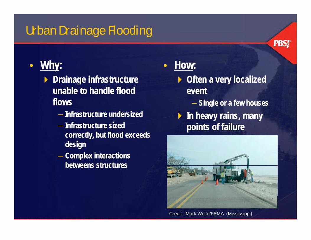
Urban Drainage Flooding
• Why:• Why: • How:• How: Drainage infrastructure
unable to handle flood flows
Drainage infrastructure unable to handle flood flows
Often a very localized event─ Single or a few houses
Often a very localized event─ Single or a few housesflows
─ Infrastructure undersized─ Infrastructure sized
correctly but flood exceeds
flows─ Infrastructure undersized─ Infrastructure sized
correctly but flood exceeds
Single or a few houses In heavy rains, many
points of failure
Single or a few houses In heavy rains, many
points of failurecorrectly, but flood exceeds design
─ Complex interactions betweens structures
correctly, but flood exceeds design
─ Complex interactions betweens structuresbetweens structuresbetweens structures
Credit: Mark Wolfe/FEMA (Mississippi)
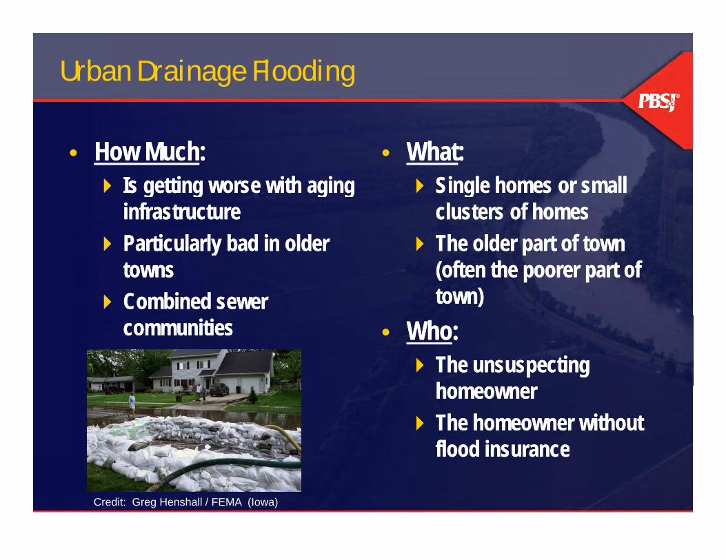
Urban Drainage Flooding
• How Much:• How Much: • What:• What: Is getting worse with aging
infrastructure Particularly bad in older
Is getting worse with aging infrastructure
Particularly bad in older
Single homes or small clusters of homes
The older part of town
Single homes or small clusters of homes
The older part of town Particularly bad in older towns
Combined sewer
Particularly bad in older towns
Combined sewer
The older part of town (often the poorer part of town)
The older part of town (often the poorer part of town)
communitiescommunities • Who: The unsuspecting
h
• Who: The unsuspecting
hhomeowner The homeowner without
flood insurance
homeowner The homeowner without
flood insuranceood su a ceood su a ce
Credit: Greg Henshall / FEMA (Iowa)
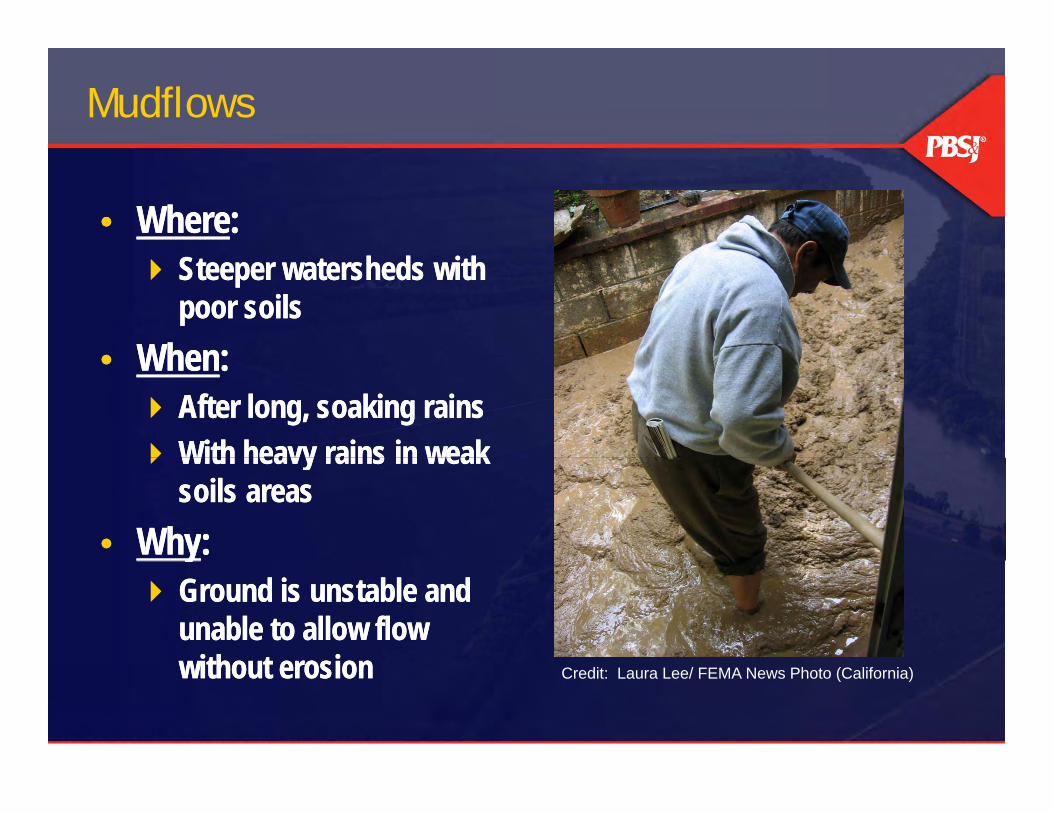
Mudflows
• Where:• Where: Steeper watersheds with
poor soils• When:
Steeper watersheds with poor soils
• When:• When: After long, soaking rains With heavy rains in weak
• When: After long, soaking rains With heavy rains in weak With heavy rains in weak
soils areas• Why:
With heavy rains in weak soils areas
• Why:y Ground is unstable and
unable to allow flow without erosion
y Ground is unstable and
unable to allow flow without erosionwithout erosionwithout erosion Credit: Laura Lee/ FEMA News Photo (California)

Mudflows
• How:• How: Massive debris flows Very short notice (or no notice) May be high velocity
Massive debris flows Very short notice (or no notice) May be high velocity May be high velocity Similar to avalanche—buries
victims
May be high velocity Similar to avalanche—buries
victims• How Much:
Impacts vary widely with • How Much:
Impacts vary widely with p y ygeography
Most common in Appalachians and California
p y ygeography
Most common in Appalachians and Californiaand Californiaand California
Credit: Laura Lee/ FEMA News Photo (California)

Mudflows
• What:• What: Doesn’t require a defined
channel Entire mountainside may
Doesn’t require a defined channel
Entire mountainside may Entire mountainside may slide
Worsened by blocking
Entire mountainside may slide
Worsened by blocking structures
• Who:structures
• Who: May impact same areas
over and over again May impact same areas
over and over againCredit: Adam DuBrowa/FEMA (California)

Coastal Flooding and Erosion
• Where:• Where: From Hurricanes: along
Eastern and Gulf coasts primarily
From Hurricanes: along Eastern and Gulf coasts primarilyprimarily
From Tsunamis: Primarily the Pacific coasts
primarily From Tsunamis: Primarily
the Pacific coasts• When:
With larger hurricanes• When:
With larger hurricanes With Nor’easters Spring tides & high winds With earthquakes (for
With Nor’easters Spring tides & high winds With earthquakes (for Credit: Dave Gately/FEMA News Photo (North Carolina) With earthquakes (for
Tsunamis) With earthquakes (for
Tsunamis)Credit: Dave Gately/FEMA News Photo (North Carolina)

Coastal Flooding and Erosion
• Why:• Why: • How:• How: Sea surface bulges due to
low pressure Sea surface bulges due to
Sea surface bulges due to low pressure
Sea surface bulges due to
Coastal surges often relatively fast rising (hours)
Coastal surges often relatively fast rising (hours) Sea surface bulges due to
earth movement Wind or current-driven waves
Sea surface bulges due to earth movement
Wind or current-driven waves
(hours) Tsunamis extremely fast
rising (minutes)
(hours) Tsunamis extremely fast
rising (minutes) Massive volume of water
over limited area Massive volume of water
over limited area Powerful waves usually
accompany Massive volume of water
Powerful waves usually accompany
Massive volume of water Massive volume of water Impacts may extend well
inland
Massive volume of water Impacts may extend well
inland
Credit: FEMA Photo/Brian Hvinden

Coastal Flooding and Erosion
• How Much:• How Much: Coastal surges and hurricanes:
Produces some of the most costly natural disasters in
Coastal surges and hurricanes: Produces some of the most costly natural disasters in costly natural disasters in history
Tsunamis: Have produced t t hi i l d l
costly natural disasters in history
Tsunamis: Have produced t t hi i l d l catastrophic single-day losses
of life in recent memory Happens most years to some
catastrophic single-day losses of life in recent memory
Happens most years to some Happens most years to some extent
Some indication surges and h i b i
Happens most years to some extent
Some indication surges and h i b i
Credit: FEMA Photo/Casey Deshong (American Samoa)
hurricanes may be getting worsehurricanes may be getting worse
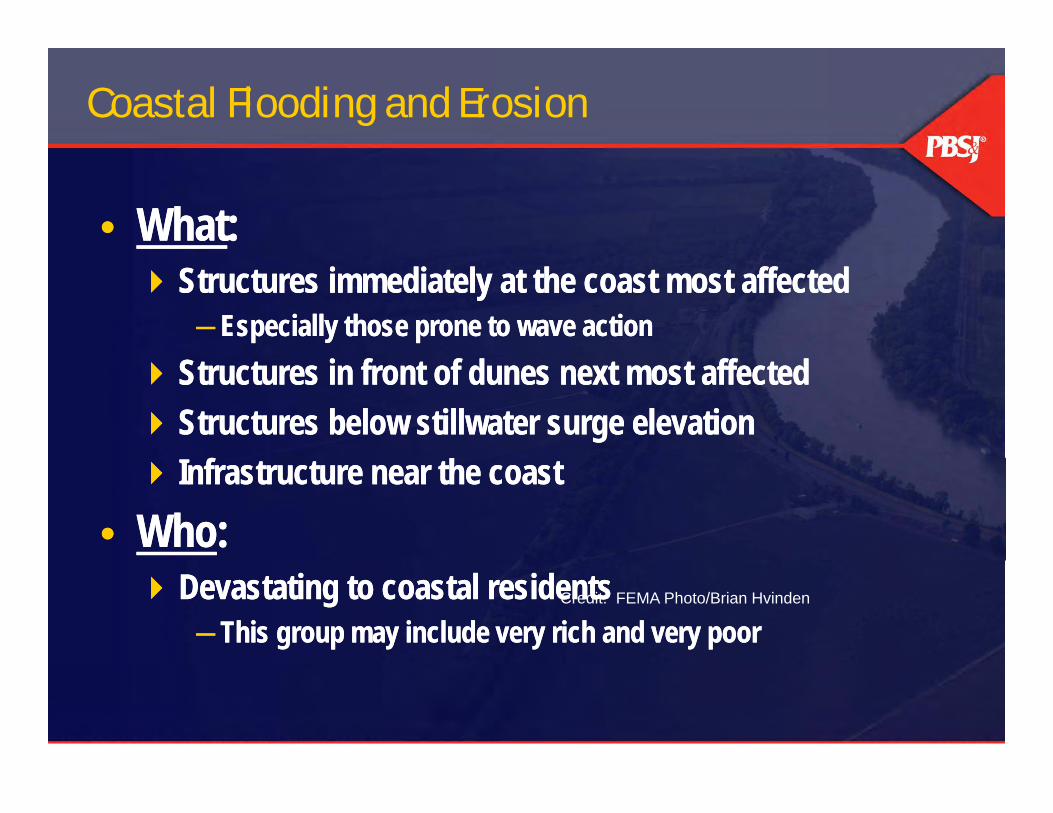
Coastal Flooding and Erosion
• What: • What: Structures immediately at the coast most affected
─ Especially those prone to wave action Structures immediately at the coast most affected
─ Especially those prone to wave action Structures in front of dunes next most affected Structures below stillwater surge elevation Structures in front of dunes next most affected Structures below stillwater surge elevation Infrastructure near the coast
• Who: Infrastructure near the coast
• Who: Devastating to coastal residents
─ This group may include very rich and very poor Devastating to coastal residents
─ This group may include very rich and very poorCredit: FEMA Photo/Brian Hvinden

Coastal Sensitivity to Sea Level Rise 2009
From “U S Climate Change Science Program S nthesis and Assessment Prod ct 4 1 Coastal Sensiti it to Sea Le el Rise AFrom: “U.S. Climate Change Science Program Synthesis and Assessment Product 4.1, Coastal Sensitivity to Sea Level Rise: A Focus on the Mid-Atlantic Region.” Lead Agency: U.S. Environmental Protection Agency. Other Key Participating Agencies: U.S. Geological Survey, National Oceanic and Atmospheric Administration, Contributing Agencies: Department of Transportation. January 15, 2009
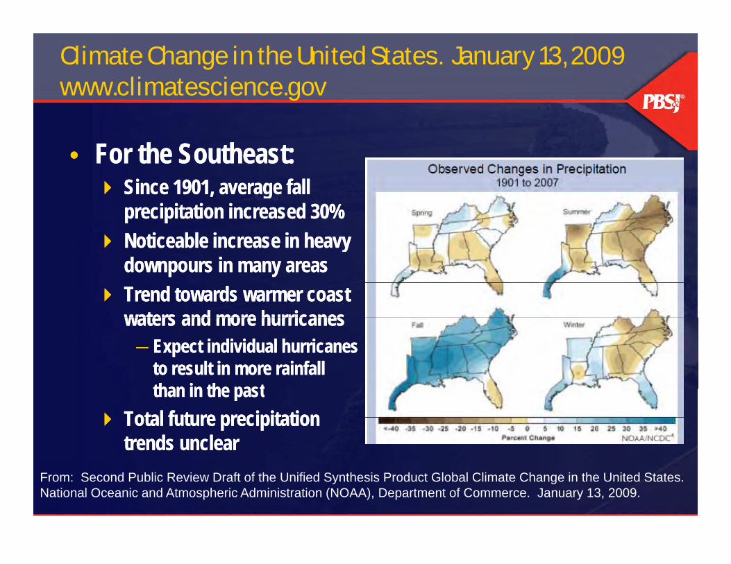
Climate Change in the United States. January 13, 2009 www.climatescience.gov
• For the Southeast:• For the Southeast: Since 1901, average fall
precipitation increased 30% Noticeable increase in heavy
Since 1901, average fall precipitation increased 30%
Noticeable increase in heavy Noticeable increase in heavy downpours in many areas
Trend towards warmer coast waters and more hurricanes
Noticeable increase in heavy downpours in many areas
Trend towards warmer coast waters and more hurricaneswaters and more hurricanes─ Expect individual hurricanes
to result in more rainfall than in the past
waters and more hurricanes─ Expect individual hurricanes
to result in more rainfall than in the pastthan in the past
Total future precipitation trends unclear
than in the past Total future precipitation
trends unclearFrom: Second Public Review Draft of the Unified Synthesis Product Global Climate Change in the United States. National Oceanic and Atmospheric Administration (NOAA), Department of Commerce. January 13, 2009.

Looking Forward—Climate Change
• Riverine flooding • Riverine flooding • Flash Floods• Structural Failure or Overtopping Floods• Flash Floods• Structural Failure or Overtopping Floods• Structural Failure or Overtopping Floods• Urban Drainage Flooding• Structural Failure or Overtopping Floods• Urban Drainage Flooding• Mudflows• Coastal Flooding and Erosion• Mudflows• Coastal Flooding and ErosionCoastal Flooding and ErosionCoastal Flooding and Erosion