flood risk management guide - brighton & hove
TRANSCRIPT

CONTENTS
SHOREHAM HARBOUR
FLOOD RISK MANAGEMENT GUIDE
SUPPLEMENTARY PLANNING DOCUMENT
SPD 13
SEPTEMBER 2015

CONTENTS
1 INTRODUCTION .................................................................................. 1
1.1 About this Document .................................................................................. 1
1.2 What is the status of a Supplementary Planning Document? .................... 2
1.3 Consultation ................................................................................................ 2
1.4 Shoreham Harbour Joint Area Action Plan (JAAP) .................................... 2
1.5 JAAP Strategic Sites .................................................................................. 4
1.6 Preparing the Flood Risk Management Guide ........................................... 7
2 FLOOD RISK PLANNING POLICY AND FLOOD DEFENCE STRATEGY CONTEXT ........................................................................ 8
2.1 Introduction ................................................................................................. 8
2.2 National Planning Policy Framework .......................................................... 8
2.3 Local Planning Policy ............................................................................... 10
2.4 Local Flood Risk Strategies, Schemes and Studies................................. 12
2.5 Condition of Flood Defences .................................................................... 14
2.6 Current Management and Maintenance Regime ..................................... 15
3 FLOOD MITIGATION APPROACHES ............................................... 16
3.1 Introduction ............................................................................................... 16
3.2 Flood Resistant and Flood Resilient Approaches .................................... 16
3.3 Flood Resistant (Dry proofing) Buildings .................................................. 16
3.4 Flood Resilient (Wet proofing) Buildings .................................................. 17
3.5 Sustainable Drainage Systems (SuDS) ................................................... 18
4 CONTEXT AND PREFERRED APPROACHES – STRATEGIC SITE 1 (SS1) – ALDRINGTON BASIN ........................................................... 22
4.1 JAAP Proposals ........................................................................................ 22
4.2 Current and Future Flood Risk ................................................................. 22
4.3 Preferred Approach .................................................................................. 24
5 CONTEXT AND PREFERRED APPROACHES – STRATEGIC SITE 2: SOUTH PORTSLADE INDUSTRIAL ESTATE ................................... 25
5.1 JAAP Proposals ........................................................................................ 25
5.2 Current and Future Flood Risk ................................................................. 25
5.3 Preferred Approach .................................................................................. 25
6 CONTEXT AND PREFERRED APPROACHES – STRATEGIC SITE 3: SOUTHWICK WATERFRONT ........................................................... 26
6.1 JAAP Proposals ........................................................................................ 26
6.2 Current and Future Flood Risk ................................................................. 26
6.3 Preferred Approach .................................................................................. 26
7 CONTEXT AND PREFERRED APPROACHES – STRATEGIC SITE 4: WESTERN HARBOUR ARM.............................................................. 28
7.1 JAAP Proposals ....................................................................................... 28
7.2 Current and Future Flood Risk ................................................................. 28
7.3 Required Design Levels ........................................................................... 28
7.4 Western Harbour Arm Frontages ............................................................. 32
7.5 Adur Ferry Bridge to Riverside Business Centre ..................................... 32
7.6 Preferred Approach .................................................................................. 35
7.7 Western Harbour Arm: Riverside Business Centre to Kingston Beach ... 38
7.8 Preferred Approach .................................................................................. 40
7.9 Western Harbour Arm: Kingston Beach ................................................... 44
7.10 Preferred Approach .................................................................................. 46
7.11 Indicative Flood Defence Network ........................................................... 48
8 PLANNING POLICY GUIDANCE ....................................................... 50
8.1 Introduction .............................................................................................. 50
8.2 Determining Planning Applications .......................................................... 50
8.3 Emerging Plan Policies ............................................................................ 51
8.4 Shoreham Harbour Joint Area Action Plan Policies ................................ 53
8.5 Shoreham Harbour Development Briefs .................................................. 54
9 GUIDING PRINCIPLES ...................................................................... 55
9.1 Introduction .............................................................................................. 55
9.2 Flood Risk Assessment............................................................................ 55
9.3 Finished Floor Levels ............................................................................... 55
9.4 Flood Defence Design Levels: Western Harbour Arm ............................. 55
9.5 Flood Defence Design Requirements: Western Harbour Arm ................. 56
9.6 Intertidal Compensatory Habitat .............................................................. 56
9.7 Contamination .......................................................................................... 57
9.8 Sustainable Drainage Systems (SuDS) ................................................... 57

LIST OF FIGURES
Figure 1.1: Flooding in Shoreham 2013 .................................................... 1 Figure 1.2: Shoreham Harbour JAAP boundary ........................................ 3 Figure 1.3: Shoreham Harbour moorings, Southwick ................................ 4 Figure 1.4: Industrial uses along Western Harbour Arm............................ 4 Figure 1.5: Strategic Sites ........................................................................ 5 Figure 1.6: Western Harbour Arm frontages ............................................. 6 Figure 3.1: Concept section of resistant property .................................... 16 Figure 3.2: Flood door and glazed screen............................................... 16 Figure 3.3: Raised door with floor guard ................................................. 17 Figure 3.4: Flood resistant UPVC door ................................................... 17 Figure 3.5: Concept section of resilient property ..................................... 18 Figure 3.6: Resilient kitchen in Brisbane ................................................. 18 Figure 3.7: Cable duct seal ..................................................................... 18 Figure 3.8: Swales at Upton, Northamptonshire ..................................... 19 Figure 3.9: Wildflower and sedum green roof ......................................... 20 Figure 3.10: Example of sustainable drainage in Germany ..................... 21 Figure 4.1: View from Basin Road North ................................................. 22 Figure 4.2: View across Aldrington Basin from Basin Road South .......... 22 Figure 4.3: SS1 and SS2 Flood Risk ...................................................... 23 Figure 4.4: Examples of flood resistant property in Hamburg .................. 24 Figure 5.1: View of Wellington Road, South Portslade ............................ 25 Figure 6.1: View of Lady Bee Marina ..................................................... 26 Figure 6.2: SS3 Flood Risk ..................................................................... 27 Figure 7.1: SS4 Flood Risk ..................................................................... 29 Figure 7.2: Floor levels with freeboard .................................................... 30 Figure 7.3: Western Harbour Arm - road and defence heights ................ 31 Figure 7.4: Adur Ferry Bridge to Riverside Business Centre - existing defences ................................................................................................. 32 Figure 7.5: Existing condition of defences at Sussex Yacht Club ............ 33 Figure 7.6: Steel sheet piling .................................................................. 36 Figure 7.7: Flood gates ........................................................................... 36 Figure 7.8: Flood wall ............................................................................. 36 Figure 7.9: Concrete revetment .............................................................. 36 Figure 7.10: Preferred Approach – Adur Ferry Bridge to Riverside Business Centre ..................................................................................... 37 Figure 7.11: Existing defences................................................................ 38 Figure 7.12: Western Harbour Arm ......................................................... 40 Figure 7.13: Preferred Approach – Riverside Business Centre to Kingston Beach ..................................................................................................... 42
Figure 7.14: Demountable defences ....................................................... 43 Figure 7.15: Renovated piles .................................................................. 43 Figure 7.16: Land raising / terracing........................................................ 43 Figure 7.17: Terraced public realm with seating ...................................... 43 Figure 7.18: Existing defences - tetrapods .............................................. 44 Figure 7.19: Existing defences - concrete revetment .............................. 44 Figure 7.20: RNLI lifeboat station ............................................................ 45 Figure 7.21: Kingston Beach village green .............................................. 45 Figure 7.22: Decorative rock armour ....................................................... 46 Figure 7.23: Rock revetment with concrete flood wall ............................. 46 Figure 7.24: Preferred Approach: Kingston Beach .................................. 47 Figure 7.25: Potential flood defence network based on recommended approaches ............................................................................................. 48
INTRODUCTION
1
1 Introduction
1.1 About this Document
This document is the Shoreham Harbour 1.1.1
Flood Risk Management Guide Supplementary Planning Document (SPD). It has been prepared by JBA Consulting, Baca Architects and the Shoreham Harbour Regeneration Partnership comprising Adur District Council (ADC), Brighton & Hove City Council (BHCC), West Sussex County Council (WSCC) and Shoreham Port Authority (SPA), working closely with the Environment Agency (EA). It will sit alongside and form part of the evidence base for the Shoreham Harbour Joint Area Action Plan (JAAP) which is a 15 year regeneration plan for the harbour area.
Parts of the Shoreham Harbour 1.1.2
regeneration area are currently vulnerable to flooding. Flooding can cause damage to property, disrupt economic and social activity and in extreme cases lead to injury and loss of life. The need to ensure adequate flood management and mitigation is therefore an important consideration in developing future plans for the area. This SPD identifies the requirements for new and improved flood defences and flood adaptation measures within the JAAP area.
The SPD will aid developers of sites 1.1.3
promoted through the JAAP to deliver a higher level of flood defence and mitigation measures than currently exists. The SPD will also help developers to demonstrate, through the planning process, that new development will be safe for its lifetime; that flood risk has not been increased elsewhere as a result of the new development; and that wherever possible, flood risk overall has been reduced.
The SPD has been developed to ensure a 1.1.4
consistent approach to flood defence infrastructure delivery in the JAAP area, taking into account wider local flood risk strategies and schemes being delivered concurrently by other organisations (refer to section 2). It also provides a guide to delivering integrated flood defence and mitigation measures to create not only distinctive, high quality structures but also a high quality, attractive public realm environment.
A supporting Technical Annex to this SPD 1.1.5
constitutes the evidence base that underpins the guidance within this document. The Technical Annex provides a full appreciation of the approach and process that has been taken to identify recommendations for flood defence and mitigation measures as well as providing outline costs of delivery.
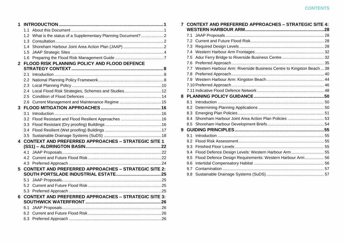
Figure 1.1: Flooding in Shoreham 20131
1 Source: ITV

2
1.2 What is the status of a Supplementary Planning Document?
Supplementary Planning Documents 1.2.1
(SPD) provide supplementary detail to policies in a development plan document (DPD). If relevant to a planning application being determined, an SPD is a material consideration that must be taken into account when determining the application. Supplementary Planning Documents should be used where they can help applicants make successful applications or aid infrastructure delivery, and should not be used to add unnecessarily to the financial burdens on development2.
It is expected that planning applications 1.2.2
relating to sites within the JAAP area will follow this guidance and ensure the recommendations and guidance as set out in Sections 4 to 9 are fully considered through the planning application process.
2 Refer to paragraph 153 of the National Planning Policy
Framework
1.3 Consultation
A four week period of public consultation 1.3.1
on the Draft SPD took place in September / October 2014. The views and considerations of interested parties were sought during that period and changes to the document were made to reflect the comments received. A second phase of public consultation was carried out in May 2015 for a four week period.
This document is the final version of the 1.3.2
SPD following these two rounds of public consultation.
A Consultation Statement3 has been 1.3.3
produced to accompany this SPD which sets out in more detail the consultation activities carried out. It also acts as a record of consultation responses made during the period and any amendments required to the SPD. The consultation process was informed by the Statements of Community Involvement for Adur District Council and Brighton & Hove City Council.
3 Refer to the Shoreham Harbour Flood Risk Management
Guide Consultation Statement (2014)
1.4 Shoreham Harbour Joint Area Action Plan (JAAP)
The Shoreham Harbour JAAP, which is 1.4.1
currently being produced, will identify a set of locally supported and sustainable proposals for Shoreham Harbour to be delivered over the next 15 years. The SPD will be cross-referred to in the JAAP policies and will be a critical element of the evidence base supporting it. It will also support and sit alongside the Adur Local Plan and the Brighton & Hove City Plan when these are adopted.
The Shoreham Harbour regeneration 1.4.2
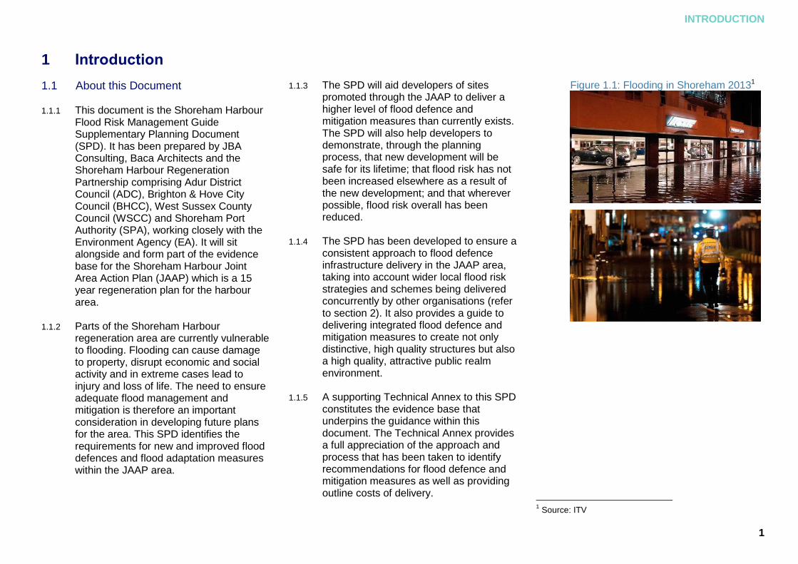
area, as identified in the JAAP, is located between the western end of Hove seafront and the Adur Estuary at Shoreham-by-Sea. The harbour stretches for five kilometres of waterfront, bounded by the A259, the West Coastway railway line and the coastal communities of Shoreham-by-Sea, Kingston-by-Sea, Southwick, Fishersgate, South Portslade and Hove. The harbour straddles the local authority boundaries of Adur District Council (within West Sussex County) to the west and the City of Brighton & Hove to the east. Figure 1.2 shows the regeneration area boundary.
INTRODUCTION
3
Figure 1.2: Shoreham Harbour JAAP boundary
4
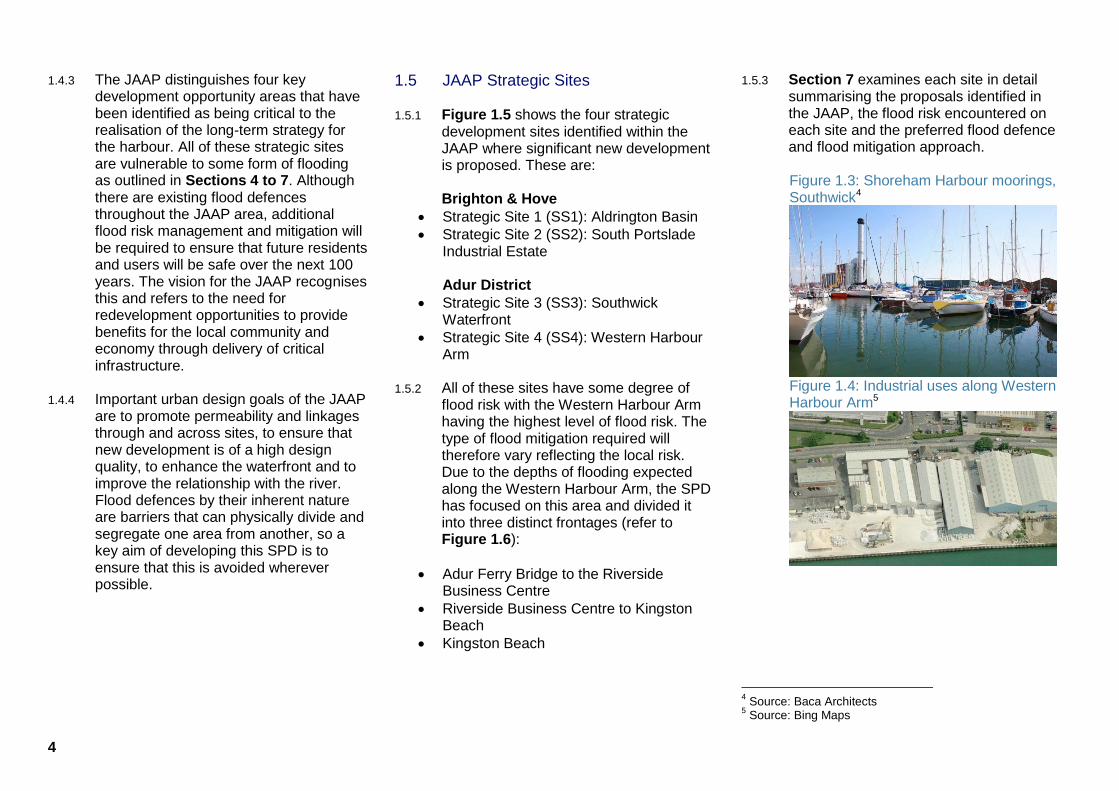
The JAAP distinguishes four key 1.4.3
development opportunity areas that have been identified as being critical to the realisation of the long-term strategy for the harbour. All of these strategic sites are vulnerable to some form of flooding as outlined in Sections 4 to 7. Although there are existing flood defences throughout the JAAP area, additional flood risk management and mitigation will be required to ensure that future residents and users will be safe over the next 100 years. The vision for the JAAP recognises this and refers to the need for redevelopment opportunities to provide benefits for the local community and economy through delivery of critical infrastructure.
Important urban design goals of the JAAP 1.4.4
are to promote permeability and linkages through and across sites, to ensure that new development is of a high design quality, to enhance the waterfront and to improve the relationship with the river. Flood defences by their inherent nature are barriers that can physically divide and segregate one area from another, so a key aim of developing this SPD is to ensure that this is avoided wherever possible.
1.5 JAAP Strategic Sites
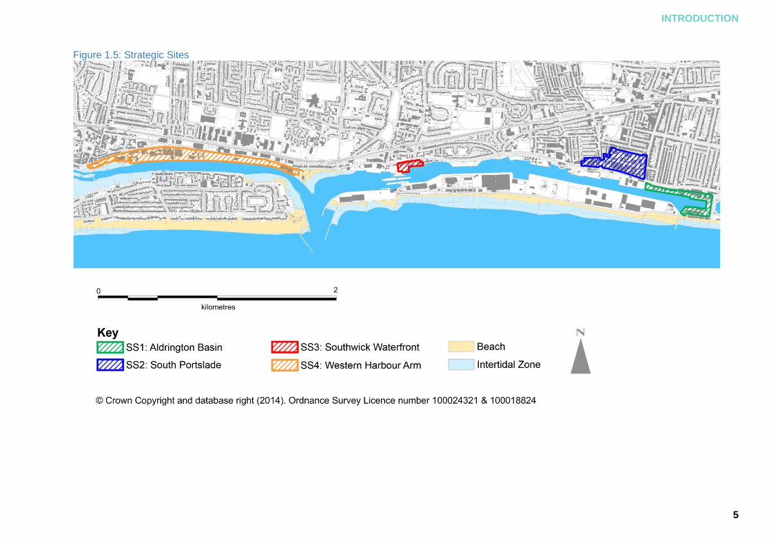
Figure 1.5 shows the four strategic 1.5.1
development sites identified within the JAAP where significant new development is proposed. These are:
Brighton & Hove
Strategic Site 1 (SS1): Aldrington Basin
Strategic Site 2 (SS2): South Portslade Industrial Estate
Adur District
Strategic Site 3 (SS3): Southwick Waterfront
Strategic Site 4 (SS4): Western Harbour Arm
All of these sites have some degree of 1.5.2
flood risk with the Western Harbour Arm having the highest level of flood risk. The type of flood mitigation required will therefore vary reflecting the local risk. Due to the depths of flooding expected along the Western Harbour Arm, the SPD has focused on this area and divided it into three distinct frontages (refer to Figure 1.6):
Adur Ferry Bridge to the Riverside Business Centre
Riverside Business Centre to Kingston Beach
Kingston Beach
Section 7 examines each site in detail 1.5.3
summarising the proposals identified in the JAAP, the flood risk encountered on each site and the preferred flood defence and flood mitigation approach.
Figure 1.3: Shoreham Harbour moorings, Southwick4
Figure 1.4: Industrial uses along Western Harbour Arm5
4 Source: Baca Architects
5 Source: Bing Maps
INTRODUCTION
5
Figure 1.5: Strategic Sites

6
Figure 1.6: Western Harbour Arm frontages

INTRODUCTION
7
1.6 Preparing the Flood Risk Management Guide
This guide has been developed through a 1.6.1
five stage process including assessment, exploring options, consultation with stakeholders and identification of preferred solutions. This process is detailed in the accompanying Technical Annex and can be summarised as follows:
STAGE 1: Assessment of flood risk
A review of existing documentation and 1.6.2
studies including the Environment Agency Flood Map and Strategic Flood Risk Assessments (SFRA) for Adur and Brighton & Hove was carried out to compare the current and future flood risk scenarios with the planned development. Strategies and plans of other flood defence schemes in the area were also reviewed. An overview of current and forecast flood risk is outlined for each site in Sections 4 to 76.
6 The Technical Annex also reviewed design life and design
levels for defences. Refer to section 3 of Appendix A of the Annex.
STAGE 2: Identification of options
Due to the greater flood depths along the 1.6.3
Western Harbour Arm, this site was the focus for developing flood defence measures. A long list of options was determined by considering all possible flood defences for the Western Harbour Arm. These were then categorised and split into types and defence alignment7. An options matrix was created to aid consideration of the feasibility of each of the flood defence types and to create a short list of options, based on the following key considerations:
applicability
cost
maintenance
adaptability
design life
environmental impact
visual impact
7 Refer to Table 2.1 of the Technical Annex
STAGE 3: Multi Criteria Analysis
Multi Criteria Analysis (MCA), which is a 1.6.4
qualitative approach to identify preferences amongst different options, was used to facilitate the options selection process and to enable the relative merits of defence options to be assessed8. A short list of preferred options was then produced and taken forward for concept design9. STAGE 4: Recommending Preferred Approaches
Based on the MCA, recommendations for 1.6.5
preferred approaches were developed for the Western Harbour Arm. Flood resistance and resilience measures as well as Sustainable Drainage System (SuDS) approaches were also recommended.
STAGE 5: Consultation and Adoption
The draft guidance was produced and 1.6.6
presented to key stakeholders to obtain preliminary feedback. The draft document then had 2 rounds of public consultation and was amended where appropriate.
8 Refer to Section 2.3 of the Technical Annex
9 Refer to Table 2.3 of the Technical Annex
8
2 Flood Risk Planning Policy and Flood Defence Strategy Context
2.1 Introduction
This section outlines the national planning 2.1.1
policy context for flood risk as well as summarising relevant local strategies and plans that aim to manage flood risk in the area.
2.2 National Planning Policy Framework
The National Planning Policy Framework 2.2.1
(NPPF) sets out the Government’s planning policies for England and how these are expected to be applied. The NPPF must be taken into account in the preparation of local planning documents and is a material consideration in all planning decisions. This SPD does not duplicate policies within the NPPF, however it does outline the key points related to flood risk and climate change.
The NPPF states that local planning 2.2.2
authorities should adopt proactive strategies to mitigate and adapt to climate change, taking full account of flood risk and coastal change considerations10.
10
Refer to Paragraph 94 of the National Planning Policy Framework
A key aim of the NPPF is to direct 2.2.3
development away from areas at highest risk. Where this is not possible and development is necessary, it must be safe without increasing flood risk elsewhere. Development Plans should take a sequential, risk based approach to the location of development to minimise risk from flooding and take account of the impacts of climate change by:
applying the Sequential Test
if necessary, applying the Exception Test
using opportunities offered by new development to reduce the causes and impacts of flooding11
Sequential and Exceptions Test
The NPPF sets out the approach for 2.2.4
passing the Sequential and Exceptions tests. The NPPF states
11
Refer to Paragraph 100 of the National Planning Policy Framework
‘The aim of the Sequential Test is to steer new development to areas with the lowest probability of flooding. Development should not be allocated or permitted if there are reasonably available sites appropriate for the proposed development in areas with a lower probability of flooding. The Strategic Flood Risk Assessment will provide the basis for applying this test. A sequential approach should be used in areas known to be at risk from any form of flooding.’12
If the development cannot be located in 2.2.5
zones with a lower probability of flooding following application of the Sequential Test, the Exception Test can be applied. The NPPF states that both of the following elements of the Exception Test need to be passed for development to be permitted:
‘it must be demonstrated that the development provides wider sustainability benefits to the community that outweigh flood risk, informed by a Strategic Flood Risk Assessment where one has been prepared; and
12
Refer to Paragraph 101 of the National Planning Policy Framework
FLOOD RISK PLANNING POLICY AND FLOOD DEFENCE STRATEGY CONTEXT
9
a site-specific flood risk assessment must demonstrate that the development will be safe for its lifetime taking account of the vulnerability of its users, without increasing flood risk elsewhere, and, where possible, will reduce flood risk overall.’13
The Sequential and Exceptions Tests 2.2.6
have been carried out for the Shoreham Harbour area
Site-Specific Flood Risk Assessment
A greater level of detail is required at the 2.2.7
planning application stage. The NPPF makes clear that appropriate development in areas at risk of flooding should only be considered by local planning authorities where, informed by a site-specific flood risk assessment, it can be demonstrated that:
‘within the site, the most vulnerable development is located in areas of lowest flood risk unless there are overriding reasons to prefer a different location; and
13
Refer to Paragraph 102 of the National Planning Policy Framework
development is appropriately flood resilient and resistant, including safe access and escape routes where required, and that any residual risk can be safely managed, including by emergency planning; and it gives priority to the use of sustainable drainage systems.’14
A checklist for carrying out site-specific 2.2.8
FRAs can be found on the online Planning Practice Guidance document15.
The Sequential and Exceptions Tests for 2.2.9
Shoreham Harbour have been undertaken through the preparation of the Adur Local Plan and Brighton & Hove City Plan (refer to section 2.3). Therefore applicants seeking planning permission will not need to apply the Sequential Test.
NPPF Planning Practice Guidance
The Planning Practice Guidance website 2.2.10
provides more detailed information to support the policies in the NPPF. The section on Flood Risk and Coastal Change16 is of relevance and provides the context for:
14
Refer to Paragraph 103 of the National Planning Policy Framework 15
Refer to the Site-Specific Flood Risk Assessment CHECKLIST on Planning Practice Guidance website 16
Refer to the Flood Risk and Coastal Change section on the Planning Practice Guidance website
The risk experienced at different Flood Zones
The vulnerability classifications for different forms of development
The forms of development appropriate in each Flood Zones.
Table 2.1 below shows the flood risk 2.2.11
table from the Planning Practice Guidance document. It provides a description of each Flood Zone with reference to the probability of river (also referred to as fluvial) and sea (also referred to as tidal) flooding, ignoring the presence of defences (except for flood zone 3b which includes the presence of defences).

10
Table 2.1 Flood Zones and definitions
Flood Zone Definition
Zone 1 Low Probability
Land having a less than 1 in 1,000 annual probability of river or sea flooding. (Shown as ‘clear’ on the Flood Map – all land outside Zones 2 and 3)
Zone 2 Medium Probability
Land having between a 1 in 100 and 1 in 1,000 annual probability of river flooding; or Land having between a 1 in 200 and 1 in 1,000 annual probability of sea flooding. (Land shown in light blue on the Flood Map)
Zone 3a High Probability
Land having a 1 in 100 or greater annual probability of river flooding; or Land having a 1 in 200 or greater annual probability of sea flooding. (Land shown in dark blue on the Flood Map)
Zone 3b The Functional Floodplain
This zone comprises land where water has to flow or be stored in times of flood. Local planning authorities should identify in their Strategic Flood Risk Assessments areas of functional floodplain and its boundaries accordingly, in agreement with the Environment Agency. (Not separately distinguished from Zone 3a on the Flood Map)
Flood Zones can be viewed on the 2.2.12
Environment Agency website17 and the Councils’ SFRAs18
On 18 December 2014, the Secretary of 2.2.13
State for Communities and Local Government produced a written Ministerial Statement setting out how Defra will be strengthening existing planning policy so that sustainable drainage systems (SuDS) will be provided in all new major developments unless proven to be inappropriate.
These changes came into effect on 6 2.2.14
April 2015. The Planning Practice Guidance has since been updated to reflect these changes19 and non-statutory technical standards for the design, maintenance and operation of SuDS have been published. Unless otherwise agreed at the pre-application stage, any major planning application must now be supported by a drainage strategy setting out how SuDS are planned to be incorporated on the site, detailed designs of the proposed systems and an associated maintenance plan for SuDS for the lifetime of the development.
17
Refer to Environment Agency website 18
Refer to the Adur and Worthing Councils Strategic Flood Risk Assessment (JBA, AWC, 2012) and the Brighton & Hove City Council Strategic Flood Risk Assessment (JBA, BHCC, 2012) respectively. 19
Refer to the Planning Practice Guide
2.3 Local Planning Policy
Adur District Council and Brighton & Hove 2.3.1
City Council are currently producing a Local Plan and City Plan respectively. These plans will, once adopted, replace the currently adopted Adur District Local Plan 1996 and the Brighton and Hove Local Plan 2005. The Shoreham Harbour JAAP is also currently being drafted. The councils have adopted Development Briefs for key sites within the Shoreham Harbour area which will be superseded by the JAAP when adopted.
Each of these documents has relevant 2.3.2
policies relating to the strategic sites or related to managing flood risk. The policies are summarised in Section 8. Developers will be expected to adhere to these policies when making planning applications in the harbour area.
The following section summarises the 2.3.3
purpose of the Strategic Flood Risk Assessment (SFRA) and the outcomes of the locally applied Sequential and Exceptions Tests carried out by the two local authorities. These are key background documents that support the emerging plans and the Shoreham Harbour JAAP.

FLOOD RISK PLANNING POLICY AND FLOOD DEFENCE STRATEGY CONTEXT
11
Strategic Flood Risk Assessments
(SFRA)
The Adur and the Brighton & Hove 2.3.4
SFRAs20 identify the flood risk experienced across the local authority areas from a range of sources including tidal (or sea), fluvial (or river) surface water and groundwater sources. They also include the future anticipated flood risk (taking into account the predicted changes associated with climate change), a detailed analysis of strategic site allocations (as proposed in the Adur Local Plan and Brighton & Hove City Plan) as well as guidance and recommendations for the local authorities and developers.
The River Adur is a tidal river. For 2.3.5
Shoreham Harbour, the predominant risk of flooding is therefore from tidal sources with some smaller areas also being at risk from fluvial and surface water flooding. The SFRAs consider what the risk of a 1 in 200 year flood event will be in the year 2115 taking into account the forecast increased sea level rise associated with climate change. The year 2115 is used as this will take into account the lifetime for any residential development (100 years as set out in the NPPF Planning Practice Guidance21).
20
Refer to the Adur and Worthing Councils Strategic Flood Risk Assessment (JBA, AWC, 2012) and the Brighton & Hove City Council Strategic Flood Risk Assessment (JBA, BHCC, 2012) respectively. 21
Refer to paragraph 26 of the NPPF Planning Practice Guidance
The Environment Agency flood maps 2.3.6
contain the most up to date information for current day tidal and fluvial flood risk. However, the Flood Zones shown on the Environment Agency’s Flood Map for Planning do not take account of the possible impacts of climate change and consequent changes in the future probability of flooding. Reference to both sets of maps should therefore be made when considering the location of proposed development, current and potential future flood risk to proposed developments.
Locally Applied Sequential and Exceptions Tests
The policy related to Shoreham Harbour 2.3.7
within the submission Brighton & Hove City Plan (BHCC, 2013) is DA8 – Shoreham Harbour and is a broad location policy. It covers the Brighton & Hove section of the JAAP area. For Adur, Policy 8: Shoreham Harbour Regeneration Area is a broad location policy in the Proposed Submission Adur Local Plan 2014 (ADC, 2014). It covers the Adur section of the JAAP area.
The Brighton & Hove Sequential and 2.3.8
Exceptions Tests document22 concludes that all proposed City Plan allocations (including DA8 - Shoreham Harbour) pass the Sequential Test.
22
Brighton & Hove Sequential and Exception Tests for the Brighton & Hove City Plan Update (BHCC,2014)
However, due to the risk of flooding 2.3.9
encountered on some sites at Shoreham Harbour, as well as the high vulnerability classification of the proposed development here, the Exception Test was also applied. It was found that the wider sustainability benefits of development at Shoreham Harbour outweigh the flood risks encountered.
Adur District Council has also carried out 2.3.10
a Sequential and Exception Tests23. Whilst the Shoreham Harbour regeneration area passes the Sequential Test, again, due to the risk of flooding encountered and the high vulnerability classification of the proposed development, the Exception Test was also applied.
It was found that the wider sustainability 2.3.11
benefits of development at this location outweigh the flood risks encountered. As such, Shoreham Harbour passes the Exceptions Test considered by both Councils. The Exception Tests document state that a site-specific FRA will be required at the planning application stage.
23
Refer to: Sequential and Exception Test for the Proposed Submission Adur Local Plan 2014 (ADC, 2014)

12
2.4 Local Flood Risk Strategies, Schemes and Studies
There are several other local area plans 2.4.1
and strategies which seek to reduce the risk of flooding and deliver infrastructure improvements:
Local Flood Risk Management Strategies
The Flood and Water Management Act 2.4.2
201024 required councils to lead the coordination of flood risk in their local areas. The Lead Local Flood Authorities (LLFA) for the JAAP area are West Sussex County Council and Brighton & Hove City Council. West Sussex County Council have produced a Local Flood Risk Management Strategy (LFRMS)25. Brighton & Hove City Council plan to publish their LFRMS soon26.
The Local Flood Risk Management 2.4.3
Strategy for West Sussex focuses on:
The risks of flooding from surface water, groundwater and ordinary watercourses but also considers flooding from rivers and the sea.
24
Please refer to the Flood and Water Management Act 2010 25
Please refer to the West Sussex Local Flood Risk Management Strategy (WSCC, 2013) 26
Please refer to the Brighton & Hove Local Flood Risk Management Strategy website
Clarification on which authority is responsible for what in relation to the management of flood risk.
Defines the role of West Sussex County Council as the LLFA.
This document identifies ‘wet spots’ 2.4.4
(areas susceptible to flooding) and notes the Shoreham and Lancing area as a priority wet spot area where risk management authorities will initially prioritise work.
No specific outcomes for tackling flood 2.4.5
risk are identified in this document, although it provides a useful summary of the flood risk experienced in the area. The strategy is focussed predominantly on addressing surface water flood risk.
Beachy Head to Selsey Bill Shoreline Management Plan (2006)
Recognising that coastal sediment 2.4.6
movements are rarely comparable with administrative boundaries, integrated Shoreline Management Plans have been produced where all the conflicting needs and constraints along the coastline are identified and considered.
Shoreham Harbour is covered by the 2.4.7
Beachy Head to Selsey Bill Shoreline Management Plan27 (2006). For the harbour area, (including the River Adur, Shoreham Port and the coastal area along the frontage at Southwick and Portslade Beaches) the Management Plan approach is to ‘hold the line’.
Rivers Arun to Adur Flood and Erosion Management Strategy (2010 – 2020)
The Rivers Arun to Adur Flood and 2.4.8
Erosion Management Strategy28 (2010) sets out how the Environment Agency and coastal local authorities in the area plan to manage flood and erosion risks along the coastline. This document builds upon the Selsey Bill to Beachy Head Shoreline Management Plan. For Shoreham Harbour, the strategy covers the stretch of coastline on the west and east banks of the river Adur (up to the A27 in the north) and through to Southwick lock gates in the east.
27
Please refer to the Beachy Head to Selsey Bill Shoreline Management Plan (SE Coastal Group, 2006) 28
Please refer to the Rivers Arun to Adur Flood and Erosion Management Strategy (2010 – 2020) (Environment Agency, 2010)
FLOOD RISK PLANNING POLICY AND FLOOD DEFENCE STRATEGY CONTEXT
13
For the west bank of the River Adur, the 2.4.9
strategy recommends a ‘hold the line – improve’ approach where defences are improved to increase the standard of protection over time, beyond the requirements of rising sea levels. The Shoreham Adur Tidal Walls Scheme (see below) is the outcome of this strategy approach.
For the east bank of the River Adur, the 2.4.10
approach is to ‘hold the line – improve’ for the northern section (from the A27 in the north to Coronation Green in Shoreham Town Centre). This section has also been included in the Shoreham Adur Tidal Walls scheme. For the central section (between the Coronation Green and Kingston Beach) the approach is to ‘hold the line – sustain’ with a programme of raised defences in the year 2020 and consideration of a tidal barrier (upstream of the river mouth) in the year 2060. Improvements to the existing walls was chosen in the short term over delivery of a tidal barrier due to the high capital cost of implementation of the barrier and adverse impacts, particularly for boat operations, biodiversity and river hydraulics. In addition, many of the tidal walls need repairing or replacing in the short term.
In 2060, the flood defence infrastructure 2.4.11
at Shoreham will be reassessed alongside the viability of a tidal barrier. If sea levels are rising faster than predicted, it may be that this option is considered earlier. The approach for the eastern section of the frontage (between Kingston Beach and Southwick Lock Gates) is ‘no active intervention’ where no improvements are identified.
Shoreham Adur Tidal Walls Scheme
The Shoreham Adur Tidal Walls scheme29 2.4.12
is an Environment Agency-led flood defence project designed to protect existing communities and infrastructure. It is currently at detailed design stage and covers a 7.2 km stretch of the river, 1.8km on the east bank between Coronation Green and the A27 and 5.4km on the west bank between the river mouth and the A2730. It is worth noting that this scheme is wholly outside of the JAAP boundary.
29
Refer to Shoreham Adur Tidal Walls Scheme on the UK Government website 30
Refer to Figure 3.4 of Appendix A of the Technical Annex
The Technical Annex31 details the design 2.4.13
heights for the proposed Shoreham Adur Tidal Walls to achieve a 1 in 300 (0.33%) standard of protection along the River Adur west and east bank reaches. An adaptive approach was taken with respect to climate change uncertainty. An assessment will be undertaken in Year 50 to confirm the preferred option for the following 50 years; this is envisaged to include either the construction of a new tidal barrier or the raising of the existing defences.
Brighton Marina to River Adur Strategy (2014)
The Brighton Marina to River Adur Flood 2.4.14
and Erosion Risk Management Strategy32 has been developed by Brighton & Hove City Council in partnership with Adur and Worthing Councils and the Environment Agency. It identifies and appraises options to manage the shoreline over the next 100 years. The strategy reviews and builds upon the coastal risk management policies proposed in the Beachy Head to Selsey Bill Shoreline Management Plan (2006).
31
Refer to Appendix A 32
Refer to Brighton Marina to River Adur Strategy on the BHCC website

14
The strategy covers the area from the 2.4.15
lock gates of Shoreham Harbour in the west, and includes the locked basin area, the eastern part of Southwick, Portslade by Sea and the open coast from the mouth of the River Adur to Brighton Marina in the east. The study area aligns with the boundaries of the neighbouring approved Arun to Adur Flood and Erosion Management Strategy.
For Shoreham Port, the strategy seeks to 2.4.16
improve the standard of defence by provision of new flood gates, flood walls and pier raising in the area immediately around the lock gates section over the next 20 years. For the areas of open coastline, the strategy seeks to raise walls at Southwick Beach, to widen the beach around Western Esplanade, to construct rock revetments and rock groynes at Southwick / Portslade beaches and to lengthen groynes in this area over the next 20 years. Further improvements are identified in the strategy for the following 20 – 100 years timespan.
The Partnership support the measures 2.4.17
outlined in the strategy. A key consideration for all of the proposals for flood defence improvements in this area is to ensure they complement each other and create a comprehensive flood defence network.
2.5 Condition of Flood Defences
Understanding the current condition of 2.5.1
flood defence infrastructure in the area is important to appreciate whether:
defences are currently fit for purpose
any repair work is required
defences would need replacing within the next 100 years and when this replacement would need to take place
A Quay Wall Survey33 for the Western 2.5.2
Harbour Arm has been carried out to inform this SPD and to aid decision makers and developers about the condition of the wharf walls at the Western Harbour Arm. More detailed surveys have been undertaken for the remaining walls along the river Adur as part of the Shoreham Adur Tidal Walls Scheme. For the section between Southwick Lock gates and the eastern end of the JAAP area, the Brighton Marina to Adur Strategy (2014) considered the condition of flood defence infrastructure.
33
Please refer to the: Adur River – Left Bank Quay Wall Survey (2014, SPA)
For the Western Harbour Arm, the Quay 2.5.3
Wall Survey (2014) notes the piecemeal construction of steel sheet piled walls on the River Adur over the last century. The wharf walls are in a varying state of repair, being constructed at different times, using numerous types of piling constructed to differing standards. The survey notes that this section of the river is an aggressive environment for steel sheet piles causing varying degrees of corrosion and weathering.
The survey inspected around 1.5 km of 2.5.4
sheet piling between the former Parcelforce site and Kingston Beach.
The survey made recommendations 2.5.5
regarding future protection or replacement of the individual sections of quay wall. This was based on an assessment of the rates of corrosion that the walls were experiencing with some walls requiring replacement in the next 20 years and others anticipated to have a serviceable remaining life of over 100 years34.
34
Please refer to Section 6 of the: Adur River – Left Bank Quay Wall Survey (2014, SPA)
FLOOD RISK PLANNING POLICY AND FLOOD DEFENCE STRATEGY CONTEXT
15
However, the survey did also note that 2.5.6
many factors other than corrosion rates can result in a shorter service life. Should effective corrosion protection systems be installed and properly maintained however, the walls may have a much longer serviceable life than the survey indicates. In any case, developers would be expected to carry out a more extensive investigation of the quay walls for their site and would need to consider the impact that loading of development would have on the quay walls.
The Brighton Marina to Adur Strategy 2.5.7
considers the condition of defences covering the other strategic sites in the JAAP. The strategy notes that ‘the residual life of the assets along the Shoreham frontage range from 15-30 years to <1 year’.
The Strategy also notes that the lock 2.5.8
gates at Shoreham Port are ‘not flood defence structures, but act as a conduit for extreme water level flooding within the basin. The current standard of protection of the lock gates is <100% Annual Exceedance Probability (AEP) (1 in 1). The impacts of increasing sea level rise will reduce the ability of the port to manage land use with increasing impacts on businesses that use the port’.
The Strategy notes that significant 2.5.9
variations in defence heights and beach widths along the frontage have resulted in a number of weak points susceptible to flooding including poorly maintained and deteriorated assets along the Southwick to Hove frontage. A low crest level at the Hove Deep Sea Anglers’ building (by Hove Lagoon) which is exposed to wave overtopping can result in flooding of Western Esplanade and Basin Road.
The storm events during Winter 2013/14 2.5.10
caused significant damage and disruption impacting factories and warehouses within Shoreham Port. Emergency repair works included the repair of breaches in seawalls and rebuilding some of the more critical groynes and revetments.
2.6 Current Management and Maintenance Regime
Shoreham Port Authority has a strategic 2.6.1
programme of defence renewal which is subject to the availability of funds and manages immediate breach risk on an ad hoc basis for the main port operational area (i.e. the lock gates eastwards).
For all other sections of the JAAP area, it 2.6.2
is the responsibility of land owners to manage and maintain their own section of riverside. The Environment Agency document Living on the Edge (EA, 2013) outlines the roles and responsibilities of riverside landowners (known as riparian landowners).

16
3 Flood Mitigation Approaches
3.1 Introduction
Before examining the strategic sites 3.1.1
individually, the following section provides an overview of flood mitigation measures that can be applied to existing and new development to reduce the impact that a flooding event could have.
3.2 Flood Resistant and Flood Resilient Approaches
For sites where flood defences are not 3.2.1
appropriate, or for buildings that cannot be protected by flood defences, alternative strategies should be implemented to reduce disruption during and following a flood. Property level flood protection must be considered with regards to flood depths at the site and measures will be dependent on both the type and predicted depth of anticipated flooding. Flood resistant and resilient measures are outlined below.
3.3 Flood Resistant (Dry proofing) Buildings
A resistant building prevents water 3.3.1
ingress (Figure 3.1) during a flood event. Flood resistance measures include flood defences, flood barriers, door guards, and back flow drains with the purpose of preventing water from entering the property – hence keeping it dry.
Typically flood resistance measures are 3.3.2
only effective for short duration, shallow flooding (below 300mm to 600mm in depth depending on structural assessment). Tests have shown that floodwater may still infiltrate different building constructions designed to resist flooding though the duration of resistance may vary. There are examples of buildings designed to withstand greater depths of flooding, but these require heavy-duty water resisting construction such as tanking, waterproof concrete and steel flood doors.
For most cases it should be assumed that 3.3.3
flood resistance measures will only be effective where predicted flood levels are no more than 300mm above the surrounding ground level.
Figure 3.1: Concept section of resistant property35
Figure 3.2: Flood door and glazed screen36
35
© Baca Architects 36
Source: Baca Architects

FLOOD MITIGATION APPROACHES
17
Figure 3.3: Raised door with floor guard37
Figure 3.4: Flood resistant UPVC door38
37
Source: Baca Architects 38
Source: Baca Architects
3.4 Flood Resilient (Wet proofing) Buildings
Resilient buildings allow water in (Figure 3.4.1
3.5) and provide protection through resilient construction and finishes. Multiple building elements require consideration, some items may include:
Floors: Solid flooring to easily wash down following a flood event.
External walls: Lime plaster to internal surfaces.
Internal partitions: Water resilient and constructed with materials that allow fast drying recovery.
Windows: Should prevent water ingress and allow safe egress at multiple locations on the building.
Doors: Made from water resilient materials.
Incoming services: All penetrations through the building fabric need to be well sealed and fitted with safety valves.
Drainage: Non-return valves should be fitted to sewage systems. All penetrations to the flood proof layer should be sealed.
Electrics: Electric appliances to be located above maximum flood level as best practice. Any fittings below the flood level should be constructed from waterproof materials.
Automated warning systems: Essential to allow the various technologies to work in synergy and provide early warning, emergency contact and automatic safety measures.
Flood emergency kit: Including First aid, documents, radio, etc. to be stored in a sealed package.
It is important to note that the approach 3.4.2
taken will be dependent on the site specifics and each site will need to be considered in context. In addition, these flood protection measures can be applied to existing residential and commercial buildings outside of the JAAP strategic site allocations where required.
18
Figure 3.5: Concept section of resilient property39
Figure 3.6: Resilient kitchen in Brisbane40
Figure 3.7: Cable duct seal41
39
© Baca Architects 40
Source: James Davidson 41
Source: Aquobex
More detail on flood resilient design is 3.4.3
available in the following documents:
Improving the flood performance of new buildings: flood resilient construction42
Flood Resilient Property43
RIBA Sustainability Hub44
42
Please refer to Flood Resilient Construction of New Buildings (CLG, 2007) 43
Please refer to Flood Resilient Property (DEFRA, 2014) 44
Refer to Sustainability Hub on the RIBA website
3.5 Sustainable Drainage Systems (SuDS)
Integration of appropriate sustainable 3.5.1
drainage systems (SuDS) should actively contribute to the quality of urban design across the Shoreham Harbour regeneration area.
SuDS should be applied to all 3.5.2
developments as set out in the Adur Local Plan Policy and Brighton & Hove City Plan Policy (Section 8).
SuDS should be designed with the goals 3.5.3
of managing flood risk, minimising the impact that surface water drainage has on water quality and the environment, increasing biodiversity by providing new habitats and improving the public realm. These goals should be key considerations in the design of SuDS for the area. Where riverside vehicular access is promoted, pollution control measures will be required to deal with surface water run-off if this is discharging straight into the river.
FLOOD MITIGATION APPROACHES
19
The selection of sustainable drainage 3.5.4
approaches should be informed by local site constraints including (but not limited to) topography, geology (soil permeability) and available area, evidencing the primacy of prevention (preventing runoff by reducing impermeable areas), or good housekeeping measures for reducing pollution; and progression through local site controls45 and source controls46 to larger downstream site and regional controls47 where appropriate. It is likely that for most sites, only site and source controls will be appropriate with the River Adur acting as the main regional control.
Dealing with water when and where it falls 3.5.5
(source control) should be the focus for any SuDS. Source control measures are often a cheaper and easier option for many developments and dealing with water at source reduces the volume of water runoff as well as the potential for contamination. Source control components within the curtilage of properties or highways areas should be encouraged (see Figure 3.8) and can include green roofs, permeable surfaces, rainwater harvesting and water butts.
45
Site controls are local facilities that will receive run-off from upstream locations, often with several inlets and only one controlled outlet. 46
Source controls include ponds and wetlands and are larger features that will collect run-off from upstream controls. 47
Regional controls include ponds and wetlands and are larger features that will collect run-off from upstream controls
Figure 3.8: Swales at Upton, Northamptonshire48
48
Source: Susdrain

20
Figure 3.9: Wildflower and sedum green roof49
49
Source: Swarthmore College Daily Gazette
Living roofs and walls can vary in type 3.5.6
from roof gardens, roof terraces, green roofs and green walls. Rainwater harvesting techniques, such as the installation of water butts, can aid in increasing the attenuation of rainfall and contribute to the on-site recycling of water. 50
Where it is demonstrated that site and 3.5.7
regional controls are required the layout and design of basins, ponds and infiltration devices including filter trips, soakaways and permeable surfaces which actively provide multiple benefits should be favoured. In particular this will include vegetated or landscaped features which provide amenity value or are shown to positively impact air quality, carbon reduction, recreation, education and other elements of community health and vitality and have monetary or intangible social value. Early consideration of the potential multiple benefits and opportunities will help deliver the best results51.
50
Wider examples of successful implementation of source control can be found at www.susdrain.org 51
Advice on SuDS is available within the latest Worthing & Adur and Brighton & Hove Strategic Flood Risk Assessments; from the Environment Agency and the Construction Industry Research and Information Association (CIRIA) online SUDS community Susdrain. The latter includes an online resource of guidance and best practice.
FLOOD MITIGATION APPROACHES
21
SuDS guidance has been produced for 3.5.8
the South East England Lead Local Flood Authorities52. ‘Water. People. Places: A guide for master planning sustainable drainage into developments’53 outlines the process for integrating SuDS into the master planning of large and small developments. This document provides a process for choosing the optimum SuDS based on the potential benefits derived as well as the applicability to the type of site being developed.
The SUSDRAIN website54 provides best 3.5.9
practice guidance on the planning, design, construction, operation and maintenance of SuDS. The SuDS Manual on this website should be referred to when identifying suitable SuDS for sites in the Shoreham Harbour regeneration area
52
Including both Brighton & Hove City Council and West Sussex County Council 53
Refer to the Shoreham Harbour Flood Risk Management page on the Adur & Worthing Councils website 54
http://www.susdrain.org/
Figure 3.10: Example of sustainable drainage in Germany55
55
Source: J Blanksby

22
4 Context and Preferred Approaches – Strategic Site 1 (SS1) – Aldrington Basin
4.1 JAAP Proposals
Aldrington Basin is located at the eastern 4.1.1
end of the JAAP area within the canal section of Shoreham Harbour with the A259 to the north and Hove Lagoon to the east (refer to Figure 1.5). It forms the eastern gateway to the harbour with the main port entrance at the junction of Wharf Road and Kingsway (A259). The basin is situated immediately adjacent to the historic Hove Lagoon and marks the end of the Hove seafront promenade and a transition to the industrial character of Shoreham Port. This area currently contains a mixture of mainly employment uses ranging from offices, retail outlets, a restaurant and pub through to light industrial, storage and port / marine-related uses in the basin.
Aldrington Basin has been identified for 4.1.2
new employment and mixed-use development to accommodate a vibrant mix of new and improved port operational facilities as well as compatible non-port employment uses. The site will also accommodate appropriately located mixed-use residential development (including approximately 300 new homes combined with SS2).
4.2 Current and Future Flood Risk
Most of SS1 - Aldrington Basin currently 4.2.1
lies within Tidal Flood Zones 2 and 3. Due to the significant differences in ground levels within the basin, some sites occupy an elevated position fronting onto the A259 Kingsway and are therefore at a low probability of flooding.
The Adur to Brighton Marina strategy 4.2.2
identified that within the locked section of Shoreham Harbour, areas are at risk of flooding due to the opening of the lock gates when the water level outside of the gates is greater than that in the basin itself. In addition, wave overtopping causes some flooding to Western Esplanade and Basin Road.
For sites between the A259 Kingsway 4.2.3
and the coast, with a 1 in 200 year probability flood event in the year 2115 and with forecast sea level rises factored in, the majority of this area is shown to be at risk from flooding (refer to Figure 4.3). The maximum flood depths for the 1 in 200 year tidal event are estimated at 0.50m, with some areas predicted to flood to a lesser depth of 0.20m. With sea level rises factored in for the year 2115, the maximum estimated flood depths increase significantly to around 1.6m with increased flood velocities.
Figure 4.1: View from Basin Road North56
Figure 4.2: View across Aldrington Basin from Basin Road South57
56
Source: Baca Architects 57
Source: Baca Architects

STRATEGIC SITE 1 – ALDRINGTON BASIN
23
Figure 4.3: SS1 and SS2 Flood Risk

24
4.3 Preferred Approach
Existing ground levels across the site vary 4.3.1
from a minimum of 3.5m Above Ordinance Datum (AOD)58 to greater than 10mAOD. A large portion of the site is at a level of less than 4.5mAOD. Residual flood risk should be dealt with through resilient and resistant design measures as set out in Section 3.2. Resistant measures are likely only to be appropriate where potential flood depths are less than 0.3m.
Surface water management should focus 4.3.2
on SuDS as set out in Section 3.5.
In relation to finished floor levels, early 4.3.3
engagement with the Environment Agency is recommended, but as a minimum, finished floor levels for residential use should be set at 5.77m AOD. Non-residential development must be designed to be safe for the proposed lifetime of the development. At this stage this is assumed to be at least a 60 year period from the date of receiving planning permission, unless otherwise agreed with the Local Planning Authority.
58 Above Ordinance Datum (AOD) is a national standard
measure. Metres Above Chart Datum (mACD) is specific to the low water mark in a specific locality. For Shoreham Harbour mAOD can be converted to mACD by adding 3.27m.
Figure 4.4: Examples of flood resistant property in Hamburg59
59
Source: J Lamond

STRATEGIC SITE 2 – SOUTH PORTSLADE INDUSTRIAL ESTATE
25
5 Context and Preferred Approaches – Strategic Site 2: South Portslade Industrial Estate
5.1 JAAP Proposals
Located to the north of the A259 and the 5.1.1
west of Boundary Road / Station Road and nestled within a residential neighbourhood (refer to Figure 1.5), South Portslade Industrial Estate is home to a diverse mix of mostly industrial premises. The site has been identified for new residential development along with new employment floorspace (including approximately 300 new homes combined with SS1).
5.2 Current and Future Flood Risk
Being in a more elevated position, SS2 - 5.2.1
South Portslade is situated in Flood Zone 1, defined as having a low probability of flooding from fluvial or tidal sources. The Brighton & Hove SFRA (2012) however does identify some parts of the area as being at risk from surface water flooding for both 1 in 30 and 1 in 200 year flood events. This can be seen on the Flood Map for Surface Water and flooding has occurred here in the past60.
60
Please refer to Flood Map for Surface Water on the Environment Agency website
5.3 Preferred Approach
The South Portslade strategic site is 5.3.1
elevated above the current and future flood extents for fluvial and tidal flooding. The minimum land level across the site is 5.5mAOD and the majority is in excess of 6.0mAOD. Traditional building construction should be appropriate and no flood defences or flood resistant / resilient measures will be required in this location. However, a detailed drainage strategy and maintenance plan will be required to support planning applications. For sites fronting onto the A259, rain gardens and/or swales should be considered as a means of attenuating surface water runoff. For all other sites, it is likely that SuDS will be required (refer to Section 3.5).
Figure 5.1: View of Wellington Road, South Portslade61
61
Source: Baca Architects

26
6 Context and Preferred Approaches – Strategic Site 3: Southwick Waterfront
6.1 JAAP Proposals
Southwick Waterfront comprises a 6.1.1
mixture of employment, marina, leisure and community uses and is located to the south of the A259 and north / east of the lock gates at the entrance to the eastern arm and canal section of Shoreham Harbour (refer to Figure 1.5). The water levels in the canal are controlled by the Southwick lock gates.
The Southwick Waterfront area comprises 6.1.2
a mix of residential, community, open space, recreational and employment uses and has been identified for new employment floorspace, provision of small scale business units, and a redeveloped and improved marina with new leisure and recreation facilities.
6.2 Current and Future Flood Risk
Within the locked section of Shoreham 6.2.1
Harbour, areas are at risk of flooding due to the opening of the lock gates when the water level outside of the gates is greater than that in the basin itself. This is the main form of flooding affecting Southwick Waterfront.
Sections of SS3 - Southwick Waterfront 6.2.2
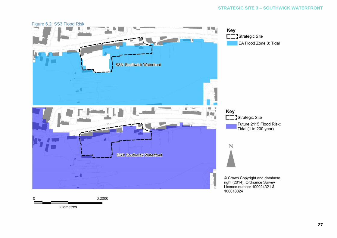
site fall within Tidal Flood Zones 2 and 3. As Figure 6.2 shows, the site is at some risk of flooding with areas within Flood Zone 3. However, when sea level rise related to climate change is factored in, all of the site is considered to be at risk from tidal flooding (refer to Figure 6.2).
The estimated flood depth for this site 6.2.3
during a 1 in 200-year tidal flood event has been shown to be relatively low (up to 0.4m). The 2115 prediction factoring in climate change however indicates that flood depths could increase to between 1m and 1.6m.
6.3 Preferred Approach
Existing land levels across the site vary 6.3.1
from 3.6mAOD to in excess of 8mAOD. The majority of the site is at a level of between 4.0mAOD and 5.0mAOD. Only the northern section of the site exceeds 5.0mAOD. Residual flood risk should be dealt with through resilient and resistant design measures as set out in Section 3.2. Resistant measures are likely only to be appropriate where potential flood depths are less than 0.3m.
In relation to finished floor levels, early 6.3.2
engagement with the Environment Agency is recommended. For non-residential development, proposals must be designed to be safe for the proposed lifetime of the development. At this stage this is assumed to be at least a 60 year period from the date of receiving planning permission, unless otherwise agreed with the Local Planning Authority.
Surface water management should focus 6.3.3
on SuDS as set out in Section 3.5.
Figure 6.1: View of Lady Bee Marina62
62
Source: Shoreham Harbour Regeneration
STRATEGIC SITE 3 – SOUTHWICK WATERFRONT
27
Figure 6.2: SS3 Flood Risk

28
7 Context and Preferred Approaches – Strategic Site 4: Western Harbour Arm
7.1 JAAP Proposals
The Western Harbour Arm is the largest 7.1.1
of the four strategic sites and is located south of the A259 between Kingston Beach in the east and the Sussex Yacht Club in the west (refer to Figure 1.5). These waterfront sites are predominantly large industrial and open storage premises including fuel storage, plastics manufacturing, aggregates handling and metal recycling.
The site has been identified for 7.1.2
comprehensive redevelopment with the aim to create an exemplar sustainable, residential-led, mixed-use area (including approximately 1100 new homes). A priority is to deliver a high-quality cycle and pedestrian route along the waterfront to create better linkages with Shoreham town centre and surrounding areas and to create a positive inter-relationship with the river environment. Future plans should also enhance the area’s natural biodiversity by incorporating multi-functional green space.
7.2 Current and Future Flood Risk
As Figure 7.1 illustrates many sites along 7.2.1
the Western Harbour Arm are currently at risk from tidal flooding. Sites between the Adur Ferry Bridge and the Riverside Business Centre in the west and around Kingston Railway Wharf and Kingston Beach in the east fall within Flood Zone 3 with sites between these two areas within Flood Zone 2.
Flood Zone 3 relates to land having a 1 in 7.2.2
200 or greater annual probability of tidal flooding. Areas within the Western Harbour Arm are at a significant risk of flooding but are not considered to be functional floodplain (described as land where water has to flow or be stored in times of flood also known as Flood Zone 3b the functional floodplain (see)).
Figure 7.1 shows the extent of a 1 in 200 7.2.3
year probability flood event encountered in this location in the year 2115 when forecast sea level rise associated with climate change is factored in. Under this scenario, almost all of the Western Harbour Arm is at risk of tidal flooding.
The main flood risk to Shoreham Harbour 7.2.4
is from tidal flooding and this risk will increase into the future as a result of sea level rise associated with climate change, necessitating the need for new flood defences. For tidal flooding the effect of channel capacity on flood risk is negligible and the decision to dredge the channel or not will have no bearing on tidal flood risk or the need to provide new flood defences.
7.3 Required Design Levels
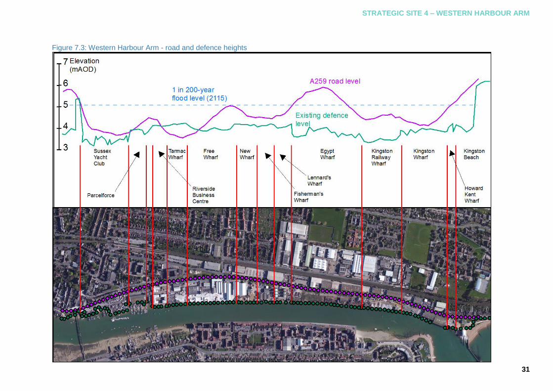
For the Western Harbour Arm, new flood 7.3.1
defences will be required to protect the site from flooding. The design height for the new flood defence will need to protect the development for its anticipated lifetime. The predicted flood level for a 1 in 200-year event in 2115 is 5.08m Above Ordnance Datum (AOD), based on UK Climate Projections (UKCP) 09.

STRATEGIC SITE 4 – WESTERN HARBOUR ARM
29
Figure 7.1: SS4 Flood Risk
kilometres

30
Freeboard (illustrated in Figure 7.2) is 7.3.2
used to provide additional allowance for a flood level to accommodate unknown factors that could contribute to flood heights greater than those calculated. An example of this would be wave action63.
Minimum freeboard allowances of 150mm 7.3.3
for hard defences (defences not subject to settlement e.g. walls) and 300mm for soft defences (defences subject to settlement e.g. embankments) are recommended. Consequently the defence design levels required for new flood defences are as follows:
5.25m AOD for hard defences;
5.40m AOD for soft defences.
For sites where existing defences / land 7.3.4
raising do not meet the defence heights outlined above, developers will be required to deliver flood defences or land raising to this height to meet this standard of protection.
Figure 7.3 shows the existing defence 7.3.5
levels and levels of the A259 across the Western Harbour Arm site.
63
Refer to Appendix A of the Technical Annex for further details on freeboard
In relation to finished floor levels, early 7.3.6
engagement with the Environment Agency is recommended. Finished floor levels should be based on the Environment Agency document: Climate Change Allowances for Planners64, but as a minimum, for residential use should be set at 5.77m AOD. Flood defence and finished floor levels are different to ensure safety of residents if defences are breached or fail. In this instance, more vulnerable uses will be less likely to flood as they are raised above predicted flood levels.
64
Refer to: Climate Change Allowances for Planners (EA 2013) or any subsequent replacement guidance.
For non-residential development, 7.3.7
proposals must be designed to be safe for the proposed lifetime of the development. At this stage this is assumed to be at least a 60 year period from the date of receiving planning permission, unless otherwise agreed with the Local Planning Authority. Finished floor levels should not be prescriptive for non-residential uses as long as flood defences and/or land raising to the design heights indicated above are implemented.
Figure 7.2: Floor levels with freeboard
STRATEGIC SITE 4 – WESTERN HARBOUR ARM
31
Figure 7.3: Western Harbour Arm - road and defence heights
32
7.4 Western Harbour Arm Frontages
This section discusses each frontage 7.4.1
(refer to Figure 1.6) in detail identifying constraints, the flood defence options considered and the preferred approaches selected. Section 4 of the Technical Annex considers phasing and delivery in detail.
7.5 Adur Ferry Bridge to Riverside Business Centre
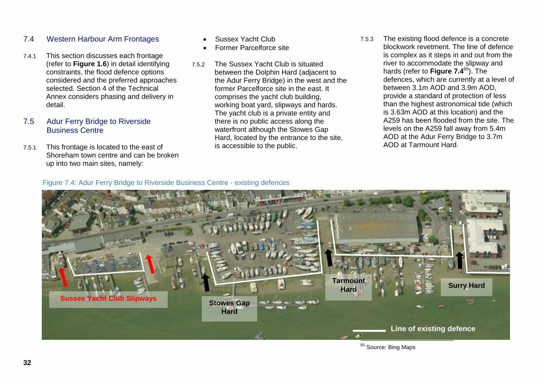
This frontage is located to the east of 7.5.1
Shoreham town centre and can be broken up into two main sites, namely:
Sussex Yacht Club
Former Parcelforce site
The Sussex Yacht Club is situated 7.5.2
between the Dolphin Hard (adjacent to the Adur Ferry Bridge) in the west and the former Parcelforce site in the east. It comprises the yacht club building, working boat yard, slipways and hards. The yacht club is a private entity and there is no public access along the waterfront although the Stowes Gap Hard, located by the entrance to the site, is accessible to the public.
The existing flood defence is a concrete 7.5.3
blockwork revetment. The line of defence is complex as it steps in and out from the river to accommodate the slipway and hards (refer to Figure 7.465). The defences, which are currently at a level of between 3.1m AOD and 3.9m AOD, provide a standard of protection of less than the highest astronomical tide (which is 3.63m AOD at this location) and the A259 has been flooded from the site. The levels on the A259 fall away from 5.4m AOD at the Adur Ferry Bridge to 3.7m AOD at Tarmount Hard.
65
Source: Bing Maps
Figure 7.4: Adur Ferry Bridge to Riverside Business Centre - existing defences
Sussex Yacht Club Slipways Stowes Gap
Hard
Tarmount
Hard Surry Hard
Line of existing defence

STRATEGIC SITE 4 – WESTERN HARBOUR ARM
33
Figure 7.5: Existing condition of defences at Sussex Yacht Club66
66
Source: Baca Architects
In flood risk terms the site is currently a 7.5.4
weak point in the network as the low crest levels of the existing defences offers a preferential route for flooding to affect a wider area of Shoreham town centre and could potentially allow flood waters in behind new defences constructed on adjacent sites.
To facilitate yachting and boat yard 7.5.5
activities, slipways or other forms of waterfront access must remain. However, it is not practical to raise the crest of the slipways (to the required flood protection levels) as steep gradients may be prohibitive to boat use. Demountable defences such as flood gates should be included at the crest of slipways to address this and to ensure a continuous defence line. Consolidation of existing slipways to a smaller number, possibly a single slipway, would be beneficial. The incorporation of stepped quays at existing hards may be appropriate. There are currently no plans to redevelop the yacht club site more comprehensively in the foreseeable future.
The former Parcelforce depot site to the 7.5.6
east of the yacht club is located between two hards (Tarmount Hard in the west and Surry Hard in the east) and bounded by the A259 and the Surry Boat Yard. There is currently no access along the waterfront although both hards are accessible to the public.
The site is currently defended by steel 7.5.7
sheet piles on two sides (west and south) with crest levels of approximately 3.9mAOD. Surry Hard, a concrete structure, comprises the line of defence on the east. The A259 rises from a level of 3.7mAOD at Tarmount Hard to 4.4mAOD at Surry Hard. A technical assessment of this section should be carried out because the tie bar anchorages are badly corroded and the original pile section is thin67.
The former Parcelforce site has received 7.5.8
full planning permission68 which would see the warehouse replaced with a six-storey mixed-use development. Surry Hard would also be upgraded to provide a stepped quay wall. Flood defence would be afforded by the construction of a flood wall at a height of 5.57mAOD all around the site with demountable flood barriers at the road access to the site. There is also a plan under consideration to infill Tarmount Hard to form a new stepped quay wall at the southern end with pedestrian access69.
67
Refer to the Adur River – Left Bank Quay Wall Survey (2014, SPA) 68
Refer to application reference: AWDM/0501/12 on the Adur & Worthing Councils website 69
Refer to application reference: AWDM/0784/14 on the Adur & Worthing Councils website

34
The frontage from Adur Ferry Bridge to 7.5.9
Riverside Business Centre is subject to multiple ownership and non-concurrent plans for redevelopment. As redevelopment opportunities come forward a continuous line of flood defence must be ensured. Where an adjacent site has yet to be developed the need to consider a temporary line of defence will be required.
Future defences at the Sussex Yacht 7.5.10
Club will need to tie in with the footbridge to the west and the redevelopment at the Parcelforce site to the east. There are a number of technically feasible alignments that a new defence could follow.
The simplest from a construction 7.5.11
perspective would be to build a defence at the rear of the site along the A259. This option is technically the simplest to achieve and likely to be cheaper than other options considered. However the option has a number of public realm constraints and would:
Sever the connection between the A259 and the waterfront
Provide limited opportunities for improving public access to the site and the waterfront
Require flood gates onto the A259 to allow continued vehicular access to the site
Afford no protection to the yacht club with its operation becoming increasingly affected by rising sea levels over time
Make future re-development of the site more challenging and costly
The Sussex Yacht Club would benefit 7.5.12
from defences positioned on the riverside of their site affording the site a higher standard of protection against future flood events. To minimise the land take of raising the defences to the required height (5.25mAOD) the preference would be for a new line of defence formed from steel sheet piles with breaks in the line in order to maintain slipways and hards. This may also require the provision of flood gates to allow access to the river at slipways whilst maintaining flood protection for the site.
At the former Parcelforce site, whilst 7.5.13
planning consent has been granted, it is also necessary to consider the preferred form of any defence and how it should tie in with the wider frontage. There are a number of approaches that might be possible.
If the former Parcelforce site defences are 7.5.14
delivered as proposed then defence improvements to the Yacht Club and Riverside Business Centre will need to connect to the Parcelforce flood wall. The connection would be subject to detailed design and would depend on the flood defence option taken forward at the other sites but could include connecting two flood walls or a more complicated connection between a flood wall and a pile cap.
If the condition of the Parcelforce piles 7.5.15
precludes the current consented defence arrangement then it may be more appropriate to construct a new sheet piled defence line which could at a later date be connected with defences at the Yacht Club or Riverside Business Centre. There is the possibility that defence options at both the Yacht Club and Riverside Business Centre may include new sheet piling which could then be connected to those at the Parcelforce site.
Across the frontage there is a need to tie-7.5.16
in the proposed defences to high ground to ensure closure of the flood cell. At the Sussex Yacht Club this would require any defence to be tied in with the Adur Ferry Bridge abutments and may necessitate some amendments to Dolphin Hard as the existing levels are not high enough to prevent water coming behind the flood defences. This could constitute a flood gate or raising the hard to the flood level. Improving public accessibility to the waterfront will be a key component of any new defences and the form of defences will influence what can be constructed.
The Partnership has an aspiration to 7.5.17
improve pedestrian and cycle access in the area with an overarching vision to provide a riverside walkway and this will need to be included within any plans. It will also be necessary to integrate the slipways, hards, and stepped quays within the defence line which may require the provision of flood gates to prevent slipways having to be too steep.

STRATEGIC SITE 4 – WESTERN HARBOUR ARM
35
Defence options at this location are 7.5.18
significantly influenced by the continued use of the frontage to support yachting and boat yard activities, together with the extant planning permission granted at the former Parcelforce site. In the case of the water compatible uses at the yacht club and boat yards, defence options must support safe interaction with the waterfront whilst mitigating flood risk across the wider frontage to the design flood water level. In respect of the extant planning permission at the Parcelforce site there is a need to ensure that preferred flood defence options for the rest of the frontage can integrate with those already permitted in support of the immediate redevelopment.
Along this section possible defence 7.5.19
options considered were:
Concrete blockwork revetment
Flood wall on a set back alignment
Flood wall on top of existing defences
Steel sheet piling (with capping beam70)
The Technical Annex (refer to section 2.5) 7.5.20
outlines each of these options in greater detail.
70
A capping beam is a structural element that in the context of the SPD is cast over the top of the sheet piles.
7.6 Preferred Approach
The use of the yacht club site and 7.6.1
improvements to pedestrian and cycle access in this area combined with the approach taken at the former Parcelforce site will be the influencing factors in the choice of defences along this frontage. So that a coherent preferred approach can be presented it has been necessary to make a number of assumptions:
The redevelopment of the former Parcelforce site occurs as outlined in the extant planning permission.
The Sussex Yacht Club site will not be redeveloped for alternative uses.
Due to the complexity at this frontage, the 7.6.2
preferred approach has been shown to combine a number of the flood defence options, as shown in Figure 7.10 and summarised as follows:
New concrete flood wall on existing line of defence
Land raising
New sheet piling
The preferred approach at the yacht club 7.6.3
site is shown to be a combination of a new concrete flood wall to be installed on top of the existing defences and steel sheet piling with the land raised behind. The illustration shows the wall at the western end of the yacht club site and the piles at the eastern end but this is not prescribed and the extent and position of the sheet piles will depend on whether the existing revetments will take the additional loading of a flood wall. However the preferred option is configured, it will need to tie in with the flood wall at the former Parcelforce site and with any amendments to Tarmount Hard.
Throughout the yacht club site slipways 7.6.4
will require flood gates which will form a continuous line with the flood wall to prevent flood ingress to the site. Where floodgates are installed, the riparian owner will be responsible for their operation and maintenance.
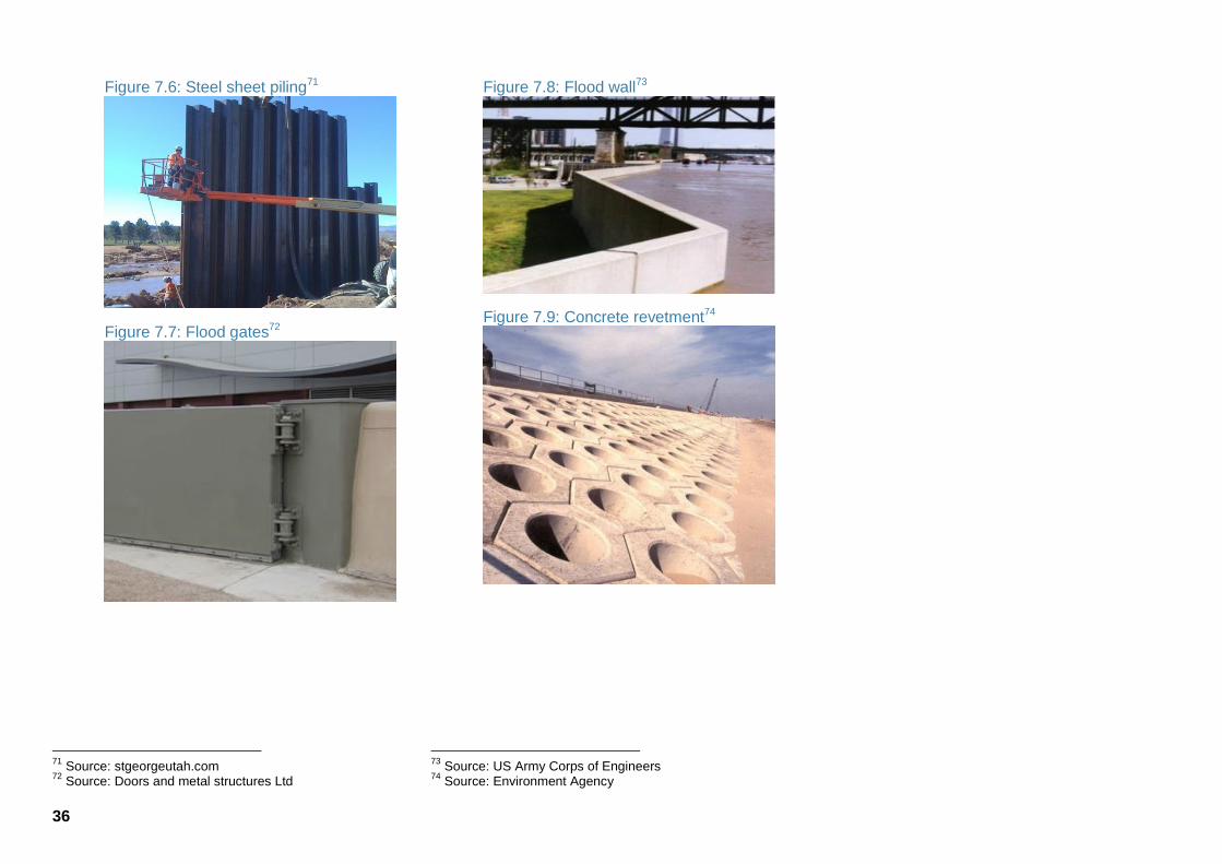
36
Figure 7.6: Steel sheet piling71
Figure 7.7: Flood gates72
71
Source: stgeorgeutah.com 72
Source: Doors and metal structures Ltd
Figure 7.8: Flood wall73
Figure 7.9: Concrete revetment74
73
Source: US Army Corps of Engineers 74
Source: Environment Agency
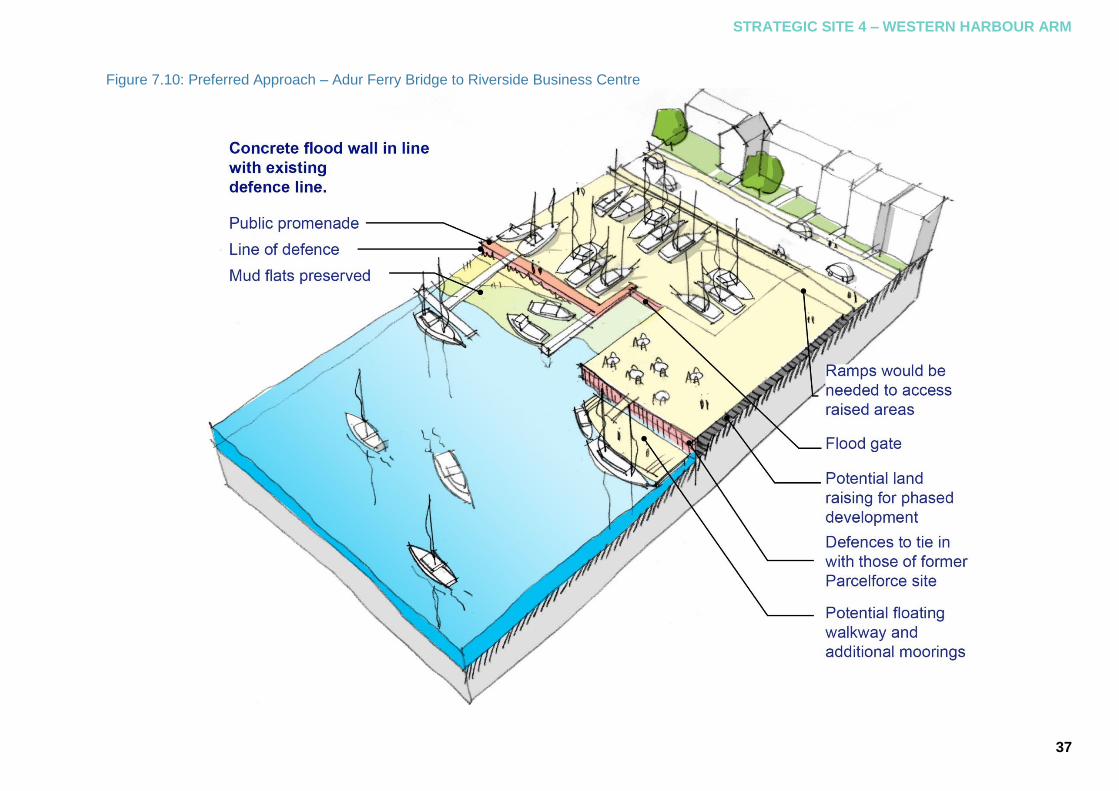
STRATEGIC SITE 4 – WESTERN HARBOUR ARM
37
Figure 7.10: Preferred Approach – Adur Ferry Bridge to Riverside Business Centre

38
As the yacht club is not being developed 7.6.5
and investment for the flood defences may be more difficult to realise, the flood wall could initially be built to provide protection to the current (2014) 1 in 200-year flood level and raised or replaced in the future. A concrete flood wall is likely to be relatively low cost compared to other defence options, however, it will result in restricted views to and across the river. Opportunity to integrate some soft landscaping features with the concrete wall to improve the aesthetics should be made.
A new concrete wall on top of the existing 7.6.6
defences would result in some loss of usable land to the yacht club; however, there is an opportunity to add pontoons and floating walkways to compensate this loss. Sheet piling could provide an opportunity for direct mooring of boats, however, this could be restricted by the presence of intertidal habitat.
If redevelopment were to occur on the 7.6.7
Sussex Yacht Club site in the future, then that would change the recommended approach as it would be beneficial to provide continuity of defences in the form of sheet piling to match the defences existing on adjacent sites and maximise the available land.
If any flood defences are proposed 7.6.8
riverward of the existing defence line, then compensatory intertidal habitat is likely to be required. The extent of compensatory habitat required will need to be identified during the planning application process, as will the location of the proposed compensatory habitat. Where proposals encroach on the river, further investigation in consultation with the Environment Agency will be necessary.
7.7 Western Harbour Arm: Riverside Business Centre to Kingston Beach
This is the longest frontage on the 7.7.1
Western Harbour Arm and is likely to deliver a high level of development. Sites located here are under numerous different ownerships. It is currently occupied by a mixture of commercial and industrial uses. The existing defences consist of sheet piling in a consistent, continuous line bordering the river.
It is not appropriate to discuss all sites in 7.7.2
detail here as the overarching principles of the preferred approach are applicable to all. However two parts of the frontage: the Riverside Business Centre and the former Minelco site require particular consideration.
Figure 7.11: Existing defences
The Riverside Business Centre currently 7.7.3
comprises a number of small business units. It is located to the east of Surry Hard and adjoins Tarmac Wharf. The site is currently defended by steel sheet piles with a crest level of 4.1-4.2mAOD. These piles are severely affected by Microbially Induced Corrosion (MIC), also known as Accelerated Low Water Corrosion (ALWC), and have a residual life of only 20 years if corrosion protection is not installed in the near future75. The section of the A259 along the site falls from a level of 4.5mAOD at the entrance road to the site to 3.8mAOD at the entrance to Tarmac Wharf.
75
For further information, please refer to the Adur River – Left Bank Quay Wall Survey (SPA, 2014)
STRATEGIC SITE 4 – WESTERN HARBOUR ARM
39
At the present time there are no plans to 7.7.4
redevelop this site. However given the condition of the piles it is likely that a significant investment in the existing defences to the site will be required in the near future and the opportunity to bring them up to the standard proposed across the Western Harbour Arm might exist.
The requirements of a new defence for 7.7.5
this site would be the same as for other locations along this frontage (as described in the preferred approach below) that is, to refurbish the existing piles and construct a new flood wall to the required level. This would also provide the opportunity to raise ground levels behind the defence as required. In light of the low residual life of the existing piles a corrosion protection system must be installed in the near future.
Further corrosion of the piles will 7.7.6
necessitate the need for replacement piles. In this scenario, it would be more cost effective to raise any new piles to the design flood level instead of the provision of a new flood wall. If this approach were taken, it could lead to significantly different pile heights along the frontage, would require a more complicated connection detail with adjacent flood defences and may give rise to poor aesthetic design. It may also impact on the riverside route alignment.
If new flood defences on adjacent sites 7.7.7
are set back from the edge of the river to allow for the riverside route (as reflected in the preferred approach), consideration of either flood gates or land raising (i.e. ramps) would be needed if access through or over the defence is required.
The land adjacent to Ham Business 7.7.8
Centre (former Minelco site) includes Tarmac Wharf and Free Wharf. This area is partially derelict and the remainder comprises warehouse units. There is no public access across the sites except at Humphrey’s Gap where a public hard is located. The defences to the sites comprise steel sheet piles with the crest height varying from 3.8-4.2mAOD. The piles at Tarmac Wharf will need replacing as they have been deemed to be failing whilst those for Free Wharf should last in excess of 100 years although extending the cope76 is recommended77. The level of the A259 varies from 3.5mAOD at Humphreys Gap to 5.0mAOD at New Wharf. The main public realm consideration will be the provision of access to the waterfront and the opportunities this presents. This may ultimately determine the preferred form and location of the defence in this location.
76
Coping refers to the concrete capping or covering of the top of the sheet pilling 77
Refer to the Adur River – Left Bank Quay Wall Survey (SPA, 2014)
Plans have been submitted to the 7.7.9
council78 for a mixed use redevelopment of the site including a supermarket and residential units. The plans showed a 1.2m high flood wall along the river frontage with a strip of land for the riverside route included behind this wall. It is considered unlikely that this development will now proceed. Regardless, it will be necessary to replace the sheet piles at Tarmac Wharf which, despite having significant residual life against corrosion, are at the point of failure due to bending79. If this site is developed as a single entity, it may make replacement of all the piles up to the flood level more cost effective than constructing a flood wall.
The remainder of this frontage is currently 7.7.10
protected by a continuous steel sheet pile wall constructed on a wharf by wharf basis. The top of the defence level along this section varies from 3.3mAOD to 4.2mAOD. The existing defence affords a variable standard of protection against flooding and the predicted residual life estimates are summarised in Appendix A of the Technical Annex80.
78
Refer to planning application reference: AWDM/0762/13 on the Adur & Worthing Councils website 79
Refer to the Adur River – Left Bank Quay Wall Survey (SPA, 2014) 80
This is also discussed in detail in the Adur River – Left Bank Quay Wall Survey (SPA, 2014)

40
The majority of the wharves are 7.7.11
considered to have an acceptable residual life but are in need of a corrosion protection system to ensure their continuing life. Maintenance and corrosion protection should seek to extend the pile life to satisfy the 100 year design life required.
However there are several sites (Tarmac 7.7.12
Wharf and potentially Riverside Business Centre) where the piles may need to be replaced. Therefore the options presented for this frontage must consider both cases. Along this frontage the options will be either to:
refurbish existing piles and a raising of defence level on the top, e.g. raised capping, flood wall, land raise; or
new steel sheet pile wall
Whilst individual parcels of land are to be 7.7.13
developed independently, a seamless defence frontage should ultimately be attained. In the event that the adjacent defence is not being raised or is taking a different form, appropriate tie in details will be required. From the perspective of engineering construction therefore it is considered more challenging to vary between the two main options (new piles and a raised defence on the top of existing piles).
This is largely due to the complexities in 7.7.14
the tie-in details that result but the potential for development of different sites to come forward at different times and select different options could result in a poor aesthetic of changing defence levels when viewed from the opposite bank of the Adur. Where the adjacent site has yet to be developed the need to consider a temporary line of defence will be required (refer to section 4 of the Technical Annex).
Along this frontage possible defence 7.7.15
options considered were:
New sheet pile (in front of existing sheet piling)
Flood wall on existing defence alignment (refurbish existing piling)
Flood wall set back (refurbish existing piling and add pile capping)
Land raising to form new defence
The Technical Annex section 2.5 7.7.16
describes these options in greater detail.
Figure 7.12: Western Harbour Arm
7.8 Preferred Approach
The preferred approach for the frontage 7.8.1
from the Riverside Business Centre to Kingston Beach is shown in Figure 7.13 and summarised as follows:
Extend life of existing sheet piling
Concrete flood wall set back
Land raising to improve access and views of the river
Given the apparent condition of the sheet 7.8.2
piling along this frontage, it is anticipated that the existing pile life could be extended to 100 years. Any developer would be expected to investigate what measures would be necessary to extend the life of the piling as well as investigating and mitigating the potential impact that new development on the wharf side would have on the piles themselves.
The alignment of the flood wall could 7.8.3
change along the length of the harbour arm depending on specific site proposals and still be designed to integrate with existing and proposed defences. A setback distance to allow for a riverside route will be required. The public realm could be designed to allow varying levels of inundation whilst maintaining protection to development and public areas beyond the wall.

STRATEGIC SITE 4 – WESTERN HARBOUR ARM
41
This preferred approach was one of the 7.8.4
more economically viable options considered and would require less intervention to the existing site. This is based on the assumption that the existing piles are suitable for the proposed development being considered and that their serviceable life can be extended to at least 100 years. Cost associated with maintenance to the existing piles and land contamination issues must be taken into consideration.
The existing line of sheet piling would be 7.8.5
retained and there should be no encroachment into the intertidal habitat. However, it may be possible to vary the line of the defences to create articulation of the river edge, subject to consideration of the impact on flood flows and habitat encroachment.
A possible enhancement to the 7.8.6
redevelopment of the Western Harbour Arm is the inclusion of pontoons. These would offer the opportunity to break up the frontages to avoid having an extensive expanse of steel sheet piles as is the case presently between the Riverside Business Centre and Kingston Beach. Pontoons would also provide additional mooring opportunities. Pontoons offer no benefit in terms of flood defence and should be designed to be free standing structures.
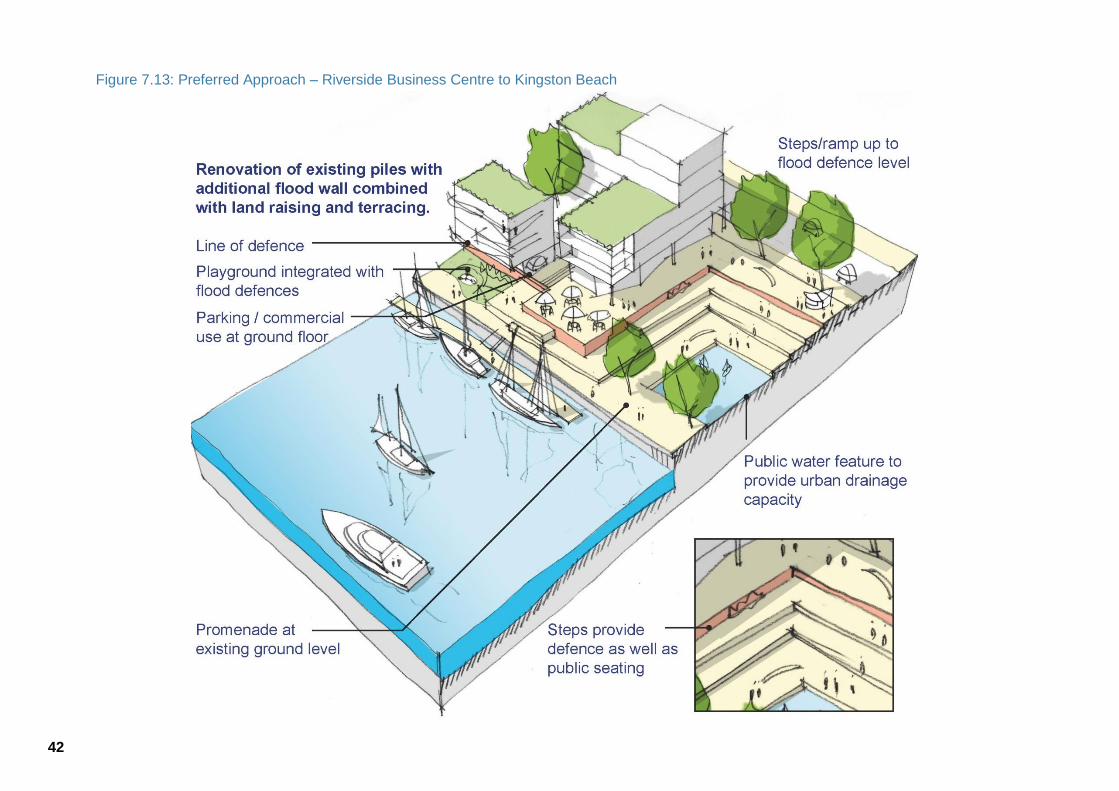
42
Figure 7.13: Preferred Approach – Riverside Business Centre to Kingston Beach
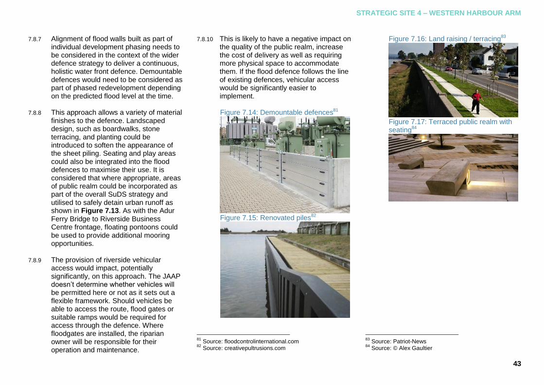
STRATEGIC SITE 4 – WESTERN HARBOUR ARM
43
Alignment of flood walls built as part of 7.8.7
individual development phasing needs to be considered in the context of the wider defence strategy to deliver a continuous, holistic water front defence. Demountable defences would need to be considered as part of phased redevelopment depending on the predicted flood level at the time.
This approach allows a variety of material 7.8.8
finishes to the defence. Landscaped design, such as boardwalks, stone terracing, and planting could be introduced to soften the appearance of the sheet piling. Seating and play areas could also be integrated into the flood defences to maximise their use. It is considered that where appropriate, areas of public realm could be incorporated as part of the overall SuDS strategy and utilised to safely detain urban runoff as shown in Figure 7.13. As with the Adur Ferry Bridge to Riverside Business Centre frontage, floating pontoons could be used to provide additional mooring opportunities.
The provision of riverside vehicular 7.8.9
access would impact, potentially significantly, on this approach. The JAAP doesn’t determine whether vehicles will be permitted here or not as it sets out a flexible framework. Should vehicles be able to access the route, flood gates or suitable ramps would be required for access through the defence. Where floodgates are installed, the riparian owner will be responsible for their operation and maintenance.
This is likely to have a negative impact on 7.8.10
the quality of the public realm, increase the cost of delivery as well as requiring more physical space to accommodate them. If the flood defence follows the line of existing defences, vehicular access would be significantly easier to implement.
Figure 7.14: Demountable defences81
Figure 7.15: Renovated piles82
81
Source: floodcontrolinternational.com 82
Source: creativepultrusions.com
Figure 7.16: Land raising / terracing83
Figure 7.17: Terraced public realm with seating84
83
Source: Patriot-News 84
Source: © Alex Gaultier

44
7.9 Western Harbour Arm: Kingston Beach
Kingston Beach, located at the eastern 7.9.1
end of the Western Harbour Arm, includes part of the Howard Kent Storage Solutions site and the surrounding Kingston Beach Village Green where the Shoreham Lifeboat Station and the Shoreham Rowing Club building are situated. The area is currently protected by concrete revetments and concrete armour (tetrapods). The closure of the flood cell is currently formed by a contour of high ground and varies from a level of 3.8mAOD at Howard Kent wharf to in excess of 6mAOD along the A259. The concrete revetment is at a height of approximately 4mAOD. This location marks the end of the continuous steel sheet piled defences that run from the Riverside Business Centre in the west. The existing defence level is below the current (2014) 1 in 200-year flood level.
This frontage differs to the other two 7.9.2
frontages in that it is directly exposed to the sea and therefore, wave action on the defences will occur. Consequently, defences subject to settlement or erosion e.g. embankments are impractical. Defences in this location should have the capability to dissipate wave energy. In addition a physical barrier is required to stop overtopping by waves.
Whilst individual parcels of land are to be 7.9.3
developed independently along the Western Harbour Arm, a seamless defence frontage should ultimately be attained. In the event that the adjacent defence is not being raised or is taking a different form, appropriate tie in details will be required. Where the adjacent site has yet to be developed the need to consider a temporary line of defence will be required. At Kingston Beach there are two areas where the defence will require a tie-in.
A tie-in to the higher ground, located 7.9.4
along the line of the A259 (Brighton Road) is required to close off the flood cell. Without this, flood water may inundate defended areas by coming around the rear of the proposed defences causing flooding on the A259 road affecting sites on the Western Harbour Arm. The levels along the A259 in the vicinity of Kingston Beach are high enough that a landward return of the flood defence could be connected into the pavement along the A259. There are a number of potential routes for this return to follow85.
85
These are outlined in more detail in section 4.3 of the Technical Annex.
Figure 7.18: Existing defences - tetrapods86
Figure 7.19: Existing defences - concrete revetment87
86
Source: Baca Architects 87
Source: Baca Architects

STRATEGIC SITE 4 – WESTERN HARBOUR ARM
45
The second tie-in relates to the 7.9.5
connection at Howard Kent Wharf where any new defence would have to connect with the pile capping beam or flood wall proposed for that site.
The effect of any new defence scheme on 7.9.6
the Royal National Lifeboat Institution (RNLI) lifeboat station needs to be considered and checked to ensure that flood risk is not increased and that access is maintained. As the lifeboat station is a water compatible use it is not considered likely that it would be impacted. Nevertheless, it is paramount that the construction of new defences should not impede the operation of the lifeboat station in any way.
Figure 7.20: RNLI lifeboat station88
88
Source: Baca Architects
The existing defence at Kingston Beach 7.9.7
has recently (winter 2013/2014) failed and is currently being replaced as part of funding from the Government’s Asset Recovery Programme. It is understood that the Asset Recovery funds can only be used to construct a like-for-like defence i.e. no betterment in the standard of protection afforded or change in defence type. In each of the options considered below it is considered that the failed revetment will have been replaced by a similar revetment.
The site is critical as the gateway to the 7.9.8
Western Harbour Arm from the east marking the start of the riverside route here. Any defence and tie-in will need to accommodate the access requirements for pedestrians and cyclists using this route and should be of a high design quality to make the route an attractive and inviting entrance way. Of critical consideration will be the requirement to de-designate a section of the village green should any flood defence solution be required to pass through the allocation. This would involve gaining consent from the Secretary of State to have the land deregistered as a village green. If the land to be deregistered is more than 200 sq m, a similar piece of land should be offered as an alternative.
Figure 7.21: Kingston Beach village green89
89
Source: Shoreham Harbour Regeneration
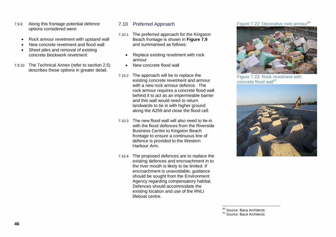
46
Along this frontage potential defence 7.9.9
options considered were:
Rock armour revetment with upstand wall
New concrete revetment and flood wall
Sheet piles and removal of existing concrete blockwork revetment
The Technical Annex (refer to section 2.5) 7.9.10
describes these options in greater detail.
7.10 Preferred Approach
The preferred approach for the Kingston 7.10.1
Beach frontage is shown in Figure 7.9 and summarised as follows:
Replace existing revetment with rock armour
New concrete flood wall
The approach will be to replace the 7.10.2
existing concrete revetment and armour with a new rock armour defence. The rock armour requires a concrete flood wall behind it to act as an impermeable barrier and this wall would need to return landwards to tie in with higher ground along the A259 and close the flood cell.
The new flood wall will also need to tie-in 7.10.3
with the flood defences from the Riverside Business Centre to Kingston Beach frontage to ensure a continuous line of defence is provided to the Western Harbour Arm.
The proposed defences are to replace the 7.10.4
existing defences and encroachment in to the river mouth is likely to be limited. If encroachment is unavoidable, guidance should be sought from the Environment Agency regarding compensatory habitat. Defences should accommodate the existing location and use of the RNLI lifeboat centre.
Figure 7.22: Decorative rock armour90
Figure 7.23: Rock revetment with concrete flood wall91
90
Source: Baca Architects 91
Source: Baca Architects

STRATEGIC SITE 4 – WESTERN HARBOUR ARM
47
Figure 7.24: Preferred Approach: Kingston Beach
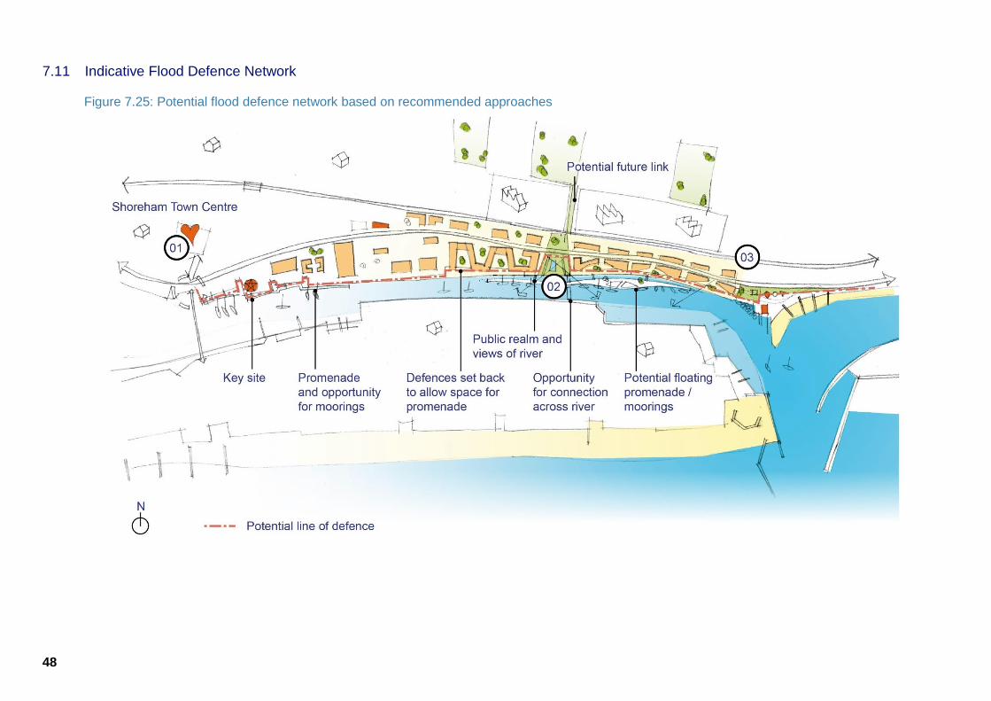
48
7.11 Indicative Flood Defence Network
Figure 7.25: Potential flood defence network based on recommended approaches

STRATEGIC SITE 4 – WESTERN HARBOUR ARM
49

50
8 Planning Policy Guidance
8.1 Introduction
This section outlines the policy 8.1.1
requirements outlined in local planning documents in relation to flood risk management and infrastructure provision. This section outlines what would be expected of applicants through the planning process.
8.2 Determining Planning Applications
ADC and BHCC are the local planning 8.2.1
authorities for Shoreham Harbour, responsible for preparing local planning documents and determining the majority of planning applications. For sites within the ADC part of the Harbour WSCC determines planning applications for some forms of development.
WSCC are the Lead Local Flood Authority 8.2.2
(LLFA) for the Adur section of the regeneration area, whilst BHCC are the LLFA for the Brighton & Hove section of the regeneration area. Both WSCC and BHCC have responsibility for surface and groundwater flooding and other responsibilities derived from the Flood and Water Management Act 2010.
Local Planning Authorities must consult 8.2.3
with the Environment Agency (EA) on any proposed developments at risk from flooding before making a decision.
The following policies should be taken 8.2.4
into account when preparing planning applications for sites within the Harbour area. All applications will be assessed against the policies as set out below. Development that fails to meet the criteria may not be granted planning permission.
Adur Local Plan 1996
The Adur Local Plan 1996 is the currently 8.2.5
adopted plan for the Adur area. Because of changes in policy at the national level, not all policies within this plan have been saved. The plan did contain a policy specifically relating to flood risk which has not been saved. Policy AG3 of the Adur Local Plan 1996 however is of relevance and relates to infrastructure.
POLICY AG3 Major development will not normally be permitted unless the infrastructure directly required to service it can be made available at the appropriate time. Where it cannot, but is planned, permission may be granted in anticipation of this. In such circumstances, the District Planning Authority may attach a condition requiring the infrastructure to be in position before use of the development commences or may require a large development to be phased in step with infrastructure provision.
Also of relevance is Policy AB16 of the 8.2.6
Adur Local Plan 1996 which states:
‘Opportunities will be taken, when considering development proposals, to improve the river scene.’
Brighton and Hove Local Plan 2005
The adopted Brighton and Hove Local 8.2.7
Plan 2005 contains the following saved policies relating to flood risk and infrastructure.
SU4 Surface water run-off and flood risk
Development will not be permitted if:
a. it would increase the risk of flooding; b. it is located in an area at risk from
flooding; and / or c. the additional surface water run-off would
be liable to harm people, property or the environment.
Where appropriate, conditions will be imposed or a planning obligation sought in order to ensure that effective preventative measures are provided. The preventative measures used must be environmentally friendly, without detriment to the site, land elsewhere, people, animals, property and nature conservation.
Sustainable urban drainage systems should be utilised and 'green' or 'alternative' roofs and other measures to minimise surface water run-off from sites should be incorporated where practicable and appropriate.

PLANNING POLICY GUIDANCE
51
In the exceptional circumstances that development on the rural fringes of the city and within rural areas of the town is otherwise acceptable, it will be required to take account of flooding and the seasonal appearance of streams in apparently 'dry' valleys. Where insufficient information is available regarding suspected surface water runoff and / or flood risks, the applicant will be required to carry out a detailed technical investigation to evaluate the extent of the risk. SU15 Infrastructure Planning permission will only be granted for development where adequate services and infrastructure either already exist or will be provided in time to serve the development without detriment to existing users or the environment. Where appropriate, the planning authority will impose conditions and / or seek a legal agreement in order to:
a. require development to be phased with the provision of programmed services or infrastructure; and / or
b. secure an appropriate contribution towards, or the direct provision of, the necessary services or infrastructure.
8.3 Emerging Plan Policies
Proposed Submission Adur Local Plan 2014
The emerging Adur Local Plan will 8.3.1
replace the Adur Local Plan 1996 when it is formally adopted by the Council. Policies are subject to change before formally being adopted. The Proposed Submission Adur Local Plan 2014 sets out the proposed flood risk management policy under Policy 37: Flood Risk and Sustainable Drainage.
Policy 37: Flood Risk and Sustainable Drainage The Council will work with relevant bodies to ensure that flood risk in Adur is reduced. A site specific flood risk assessment must be submitted with planning applications for:
Proposals of 1 hectare or greater in Flood Zone 1
All development30 or changes of use to a more vulnerable use in Flood Zones 2 and 3
All development31 or changes of use to a more vulnerable use, regardless of flood zone or size, where flood risk from other sources (surface water, sewer, groundwater) is identified by the Strategic Flood Risk Assessment.
The flood risk assessment will need to demonstrate that development:
is appropriately flood resilient and resistant, includes safe access and escape routes where required, and that any residual risk can be safely managed;
will be safe for its lifetime taking account of the vulnerability of its users;
will not increase flood risk (including sewer flooding, surface water and groundwater flood risk) elsewhere;
will, where possible, reduce flood risk overall; and
will give priority to the use of sustainable drainage systems.
The flood risk assessment will also need to demonstrate that, where possible, higher vulnerability uses have been located on parts of the site at the lowest probability of flooding. New development within Adur must include some form of Sustainable Drainage System (SuDS) or other appropriate design measures in order to reduce the risks of surface water flooding and to mitigate the risk of pollution to groundwater sources. SuDS should be considered before other forms of disposal. Substantial storage through SuDS will be required to achieve a reduction in runoff to levels below that experienced prior to development. On relevant sites, storage of runoff during the high part of the tidal cycle should be addressed. SuDS must be designed sensitively and must seek to enhance landscapes, increase biodiversity gains, and provide quality spaces.

52
For all developments, applicants will be required to demonstrate that acceptable management arrangements are in place and funded to ensure the ongoing maintenance of SuDS into the future. Where it is not practical to provide SuDS on site, the development of strategic level SuDS may be considered appropriate. In these circumstances, contributions may be required through s106 undertakings/ CIL. 30
Excluding ‘minor development’ as defined in paragraph 046 of the National Planning Policy Framework Planning Practice Guidance. 31
See above footnote.
The Proposed Submission Adur Local 8.3.2
Plan 2014 also sets out the approach in relation to delivery of infrastructure as set out in Policy 30: Delivering Infrastructure.
Policy 30: Delivering Infrastructure Development will be required to provide or contribute to the provision (and where appropriate, maintenance) of facilities, infrastructure and services made necessary by development, or where it gives rise to a need for additional or improved infrastructure. The Council will work with partners including infrastructure and service providers and stakeholders to ensure that the necessary physical, economic, social and environmental infrastructure is provided to support development.
Infrastructure should be provided at the appropriate time, prior to the development becoming operational or being occupied. Larger developments may need to be phased to ensure this requirement can be met. Prior to the adoption of a CIL charging schedule, planning obligations from developers to secure the delivery of infrastructure will be provided by way of legal undertaking or agreement pursuant to s106 of the Town and Country Planning Act 1990 (as amended). Where appropriate these will continue to be used after the adoption of CIL to secure site specific infrastructure delivery, any financial contributions and/or phasing. An Infrastructure Provision SPD will also be prepared. Proposals by service providers for the delivery of utility infrastructure to meet the needs generated by new development and by existing communities will be permitted.
In addition, and in relation to the Western 8.3.3
Harbour Arm, Policy 8: Shoreham
Harbour Regeneration Area seeks to
‘deliver a comprehensive flood defence solution integrated with a publicly accessible riverside route including pedestrian/cycle way and facilities for boat users’.
Submission Brighton & Hove City Plan (Part One) 2013
The Submission Brighton & Hove City 8.3.4
Plan 2013 will replace the Brighton & Hove Local Plan 2005 when it is formally adopted by the Council. The policies referred to below are subject to change. The Submission Brighton & Hove City Plan 2013 (with proposed modifications) sets out the proposed flood risk management policy under Policy CP11: Managing Flood Risk.
CP11 Managing Flood Risk The council will seek to manage and reduce flood risk and any potential adverse effects on people or property in Brighton & Hove, in accordance with the findings of the Strategic Flood Risk Assessment (SFRA). Development proposals in locations that have been subject to previous localised flooding events (including, surface water/muddy floods, groundwater, or sewer floods) will need to demonstrate that the issue has been taken into account and appropriate mitigation measures195 incorporated. Where a risk is identified then planning applications must be accompanied by a site specific flood risk assessment identifying how flood risk will be mitigated and minimised.

PLANNING POLICY GUIDANCE
53
Where site-specific flood risk assessments are required they must be consistent with the latest guidance in the SFRA, national planning policy framework and technical guidance, and any supplementary information from the Environment Agency. In particular development should include appropriate sustainable drainage systems196 in order to avoid any increase in flood risk and to ideally reduce flood risk. Where flood risk management or mitigation measures are required, the opportunity to simultaneously achieve wider sustainability and biodiversity objectives for the city (as identified in CP8 and CP10) should be investigated and will be encouraged. The council is producing a Surface Water Management Plan197 to manage surface water flood risk and help mitigate the effects of climate change on the city. The Council has a new role as Lead Local Flood Authority with a responsibility for surface and groundwater flooding, SuDS approval and other responsibilities derived from the Flood and Water Management Act 2010 and is a source of information and technical assistance 195 Actions to prevent, avoid or minimise the actual or potential adverse effects of a plan, policy, development, project, etc. 196 SUDS - An approach to drainage which seeks to decrease the amount of surface runoff, decrease the velocity of surface runoff, or divert it for other useful purposes, thereby reducing the contribution it makes to sewer discharge and flooding. 197 A SWMP is a framework through which key local partners with responsibility for surface water and drainage in their area work together to understand the causes of surface water flooding and agree the most cost effective way of managing surface water flood risk.
In addition, for Aldrington Basin, Policy 8.3.5
DA8 – Shoreham Harbour states the area priority:
‘To ensure that all development takes in to account the findings and recommendations of the current Flood Risk Assessment.’
8.4 Shoreham Harbour Joint Area Action Plan Policies
The JAAP, once formally adopted by Adur 8.4.1
District Council and Brighton & Hove City Council, will provide more detailed policy for the Shoreham Harbour regeneration area. The policies referred to below are in draft form and are subject to change. The specific flood risk management planning policy within the Draft JAAP (2014) is Policy JAAP 27: Managing Flood Risk and is shown in full below. This policy was publically consulted on in February 2014 and is now in the process of being updated.
Policy JAAP 27: Managing Flood Risk
i. Proposals should demonstrate how the
risks of surface water run-off and water pollution have been reduced including through the introduction of Sustainable Drainage Systems (SuDS) and water capture / recycling technology.
ii. New developments must incorporate open space, appropriate planting, green roofs and / or green walls (suitable for coastal growing conditions) to reduce levels of surface water run-off and consequent risk of flooding.
iii. Proposals which seek to provide basement parking in tidal /fluvial flood zones will only be acceptable where adequate mitigation and emergency planning are included as part of the planning application.
iv. Where development creates new flood
flow routes, the site specific FRA must assess the potential flood hazard posed by them.
v. Development proposals in the JAAP
area must comply with the Shoreham Harbour Flood Risk Management Technical Guide.
vi. Proposals must include an emergency
strategy to ensure the safety of residents at times of flooding. This should be developed in conjunction with the Councils’ Emergency Planning Officer. The maintenance and review of the strategy will be the responsibility of the development management company.
54
Two strategic site policies also refer to 8.4.2
flood risk management as detailed below. Policy JAAP 3: Aldrington Basin (SS1)
vi. In accordance with the emerging Flood
Risk Technical Guidance, development
proposals should be designed to be safe for the 1:200yr tidal flood event level to 2115 for residential uses and to 2082 for commercial development with an appropriate freeboard (i.e. the watertight safety zone above the theoretical flood level).
Policy JAAP 11: Western Harbour Arm (SS4)
x. In accordance with the emerging Flood Risk Technical Guide development should be designed to be safe for the 1 in 200 year tidal flood level to 2115 for residential and to 2082 for commercial development. Proposals should protect against a breach scenario through the application of an appropriate finished floor level assumed to be 5.77m above Ordnance Datum (AOD) for residential development and 4.94m above AOD for commercial proposals.
Other harbour-wide policies are of 8.4.3
relevance, specifically:
Policy JAAP 14: Sustainable Use of Water which identifies the need for appropriate SuDS in new development.
Policy JAAP 17: Contamination which notes the need for an assessment of contamination and the potential impacts of new development in the JAAP area.
Policy JAAP 28: Nature Conservation which notes that SuDS should benefit biodiversity.
The supporting text for the Western 8.4.4
Harbour Arm section of the JAAP also refers to the riverside route:
‘Although it is not appropriate to extend the route the entire length of Western Harbour Arm due to narrow plot depth at the eastern end, the likely setback requirement of 8m from the waterfront for flood management purposes makes the provision of a new route more deliverable. Subject to more detailed modelling and design, a total section of 12.25m from building to harbour wall would be sufficient to deliver the new route.’ 92
This setback distance has been a 8.4.5
consideration informing this Flood Risk Management Guide.
92
Please refer to section 2.10 of the Shoreham Harbour Joint Area Action Plan Draft for Consultation (2014)
8.5 Shoreham Harbour Development Briefs
Development Briefs have been prepared 8.5.1
for key sites in Shoreham Harbour. The briefs provide detailed guidance for these areas and have informed the preparation of the JAAP.
The Western Harbour Arm Development 8.5.2
Brief (ADC, 2013) has been adopted by Adur District Council as planning guidance. The principles set out in WH13 Flood Risk Management are of particular relevance in relation to flood risk. In relation to SuDS, reference should be made to WH4: Water.
The South Portslade Industrial Estate and 8.5.3
Aldrington Basin Development Brief (BHCC, 2013) has been adopted by Brighton & Hove City Council. The principles set out in SPAB23: Flood Risk and Coastal Processes are of particular relevance in relation to flood risk for the site. In relation to SuDS, reference should be made to SPAB4: Water.
Both Development Briefs refer to this 8.5.4
Flood Risk Management Guide as a key document that developers must consider when submitting applications.
FLOOD RISK MANAGEMENT SPD
55
9 Guiding Principles
9.1 Introduction
In addition to the policies identified in 9.1.1
Section 8, this SPD sets out Guiding Principles which should be taken into account when preparing planning applications for sites within the Harbour area. Development that fails to meet the criteria may not be granted planning permission.
9.2 Flood Risk Assessment
To comply with paragraph 103 of the 9.2.1
NPPF, sites identified in Guiding Principle FRMG1 should produce a site specific flood risk assessment.
FRMG 1: Flood Risk Assessment A Site-specific Flood Risk Assessment should accompany planning applications for strategic sites SS1: Aldrington Basin, SS3: Southwick Waterfront and SS4: Western Harbour Arm. The ‘Site-Specific Flood Risk Assessment CHECKLIST’93 must be completed and submitted alongside the Flood Risk Assessment as part of any planning application.
93 Refer to paragraph 068 on the Planning Practice Guidance website
9.3 Finished Floor Levels
To comply with paragraphs 102 and 103 9.3.1
of the NPPF, Policy 37: Flood Risk and Sustainable Drainage of the Proposed Submission Adur Local Plan 2014 and Policy CP 11: Managing Flood Risk of the Submission Brighton & Hove City Plan, finished floor levels of new development should be appropriately set as described in Guiding Principle FRMG2 below.
FRMG2: Finished Floor Levels Proposals for development at SS1: Aldrington Basin, SS3: Southwick Waterfront and SS4 Western Harbour Arm strategic sites in the JAAP should protect against a breach scenario through the application of an appropriate finished floor level of: 5.77m AOD for residential development For non-residential development, proposals must be designed to be safe for the proposed lifetime of the development, assumed to be at least a 60 year period from the date of receiving planning permission, unless otherwise agreed with the Local Planning Authority.
9.4 Flood Defence Design Levels: Western Harbour Arm
To comply with NPPF paragraph 102, 9.4.1
Policy 37: Flood Risk and Sustainable Drainage and Policy 8: Shoreham Harbour Regeneration Area of the Proposed Submission Adur Local Plan 2014 and Guiding Principle WH13: Flood Risk Management of the Western Harbour Arm Development Brief 2013, flood defences should be delivered alongside new development at the Western Harbour Arm in accordance with Guiding Principle FRMG3 below. These design heights take into account the lifetime of development (of 100 years) with respect to sea level rise associated with climate change.
FRMG3: Flood Defence Design Levels: Western Harbour Arm
Where undefended land levels are below the 1 in 200 year tidal flood event for 2115, land raising and/or flood defences should be provided.
Developers will be required to deliver defences and/or land raising for sites on the Western Harbour Arm to the following heights:
5.25m AOD for hard defences; 5.40m AOD for soft defences.
For sites where existing defences / land levels do not meet the heights outlined above, developers will be required to deliver flood defences or land raising to this height to meet the required standard of protection.

56
9.5 Flood Defence Design Requirements: Western Harbour Arm
It is critical that flood defence 9.5.1
infrastructure at the Western Harbour Arm forms a comprehensive defence network to provide mitigation for the entire Western Harbour Arm strategic site and to ensure that flood risk is not increased elsewhere as a result of development. To comply with paragraphs 102 and 103 of the NPPF, Policy 8: Shoreham Harbour Regeneration Area of the Proposed Submission Adur Local Plan 2014, Guiding Principle WH13: Flood Risk Management of the Western Harbour Arm Development Brief 2013, and Policy JAAP 11: Western Harbour Arm of the Shoreham Harbour Joint Area Action Plan 2014, flood defences should be delivered in line with Guiding Principle FRMG4 below.
FRMG4: Flood Defence Design Requirements: Western Harbour Arm Developments should be set back from the riverside by at least 8m from wharf wall to building for flood defence maintenance requirements. Regard to the Western Harbour Arm Development Brief should be made when submitting applications. New developments should incorporate active uses along the waterfront. This may include the provision of parks, squares, play areas and active frontages such as cafes, shops and workspace. Areas of public realm should be of a high design quality.
In consultation with the Environment Agency and Adur District Council, defences and / or land raising should be designed to ensure holistic protection from flooding for the frontage stretching from the Adur Ferry Bridge to Kingston Beach. In protecting individual sites, flood mitigation measures should positively contribute towards delivery of the wider flood defence network as identified in this SPD. Temporary defences may be applicable where neighbouring sites are yet to be developed. Planning applications should illustrate how the flood defence solution being proposed meets the aims of providing a holistic approach to flood defence delivery. For each frontage along the Western Harbour Arm, proposals should clearly demonstrate consideration of the preferred approaches as detailed in Section 7 of this SPD. Flood defences should be designed to tie-in with existing defences or land levels that meet the design heights referred to under Guiding Principle FRMG3. Where proposals seek to retain existing wharf walls as part of the flood defence infrastructure, an extensive structural survey will be required to ensure the development will be safe for its lifetime. Regard should be made to the provision of pontoons and mooring opportunities as part of delivery of new flood defences. Pontoons should be designed to be freestanding structures.
Where boats are to be moored directly on to piling, a structural survey is required to consider whether defences could take the loading over their expected lifetime. Access to existing public hards must remain. Maintenance arrangements should be agreed with the Environment Agency and the local planning authority prior to construction.
9.6 Intertidal Compensatory Habitat
Where new development encroaches into 9.6.1
the river, an assessment of the impact on intertidal habitat will be required. Where there is an impact, this should be mitigated as outlined in Guiding Principle FRMG5 below to comply with Paragraph 118 of the NPPF.
FRMG5: Intertidal Compensatory Habitat Any scheme must avoid causing harm to biodiversity in the first instance. If it cannot be avoided then the impacts need to be adequately mitigated, or, as a last resort, compensated for according to the National Planning Policy Framework. Schemes should incorporate measures designed to deliver ecological enhancements. Consultation with the Environment Agency is necessary for proposals which encroach into the river environment. For such schemes, applicants should:

FLOOD RISK MANAGEMENT SPD
57
avoid negative ecological impacts
reduce negative impacts that cannot be avoided; and
compensate for any remaining significant negative ecological impacts
Where compensatory intertidal habitat is required, applicants should:
calculate the area of habitat loss through undertaking up-to-date surveys;
compensate for habitat loss on a like for like basis, providing the same area and quality of habitat being lost;
Identify / deliver sites for compensation appropriate to habitats and species they are designed to support.
For further guidance review the chartered Institute of Ecology and Environmental Management technical guidance
Management agreements should be included as part of the planning application for sites of compensatory habitat to ensure the long term integrity for wildlife benefit.
9.7 Contamination
Due to the potentially high levels of 9.7.1
contamination on sites at the Western Harbour Arm, proposals should ensure careful consideration of the impacts that flood defence infrastructure may have on mobilising or disturbing contaminants. To comply with paragraph 120 of the NPPF,
Policy 35: Pollution and Contamination of the Proposed Submission Adur Local Plan 2014, Policy JAAP 17: Contamination of the Shoreham Harbour Joint Area Action Plan 2014 and Guiding Principle WH7: Contamination of the Western Harbour Arm Development Brief 2013, piling assessments should be carried out at the Western Harbour Arm, as outlined in Guiding Principle FRMG6 below.
FRMG6: Contamination: Western Harbour Arm
Where sheet piling is being proposed, a piling risk assessment must be carried out to demonstrate that any proposed piling will not result in contamination of groundwater or migration of contamination off-site. Displacement piling methods are generally preferred on contaminated sites as they produce no spoil so that contamination is not exported to the surface.
9.8 Sustainable Drainage Systems (SuDS)
SuDS should be delivered onsite to be in 9.8.1
accordance with paragraph 103 of the NPPF, Policy 37: Flood Risk and Sustainable Drainage of the Proposed Submission Adur Local Plan 2014; Policy CP11: Managing Flood Risk of the Submission Brighton & Hove City Plan 2013 and Policy JAAP 27: Managing Flood Risk of the Shoreham Harbour Joint Area Action Plan 2014. The approach outlined in Guiding Principle FRMG7 below should ensure the most appropriate system is delivered.
FRMG 7 Sustainable Drainage Systems (SuDS) Appropriate SuDS should be delivered at all new developments within the JAAP area. Applications should follow the approach set out in the following publications (or subsequent replacement documents):
Adur & Worthing Councils and/or Brighton & Hove Council’s SFRAs
Water. People. Places: A guide for master planning sustainable drainage into developments
CIRIA SuDS Manual Pollution control measures will be required to deal with surface water run-off where this is discharging straight into the river. This is especially relevant where riverside vehicular access is promoted.


60