flood emergency plan · web viewthe command, control and coordination arrangements in this...
TRANSCRIPT

Indigo ShireFlood Emergency Plan
A Sub-Plan of the Municipal Emergency Management Plan
For Indigo Shire And
VICSES North East Region and the Beechworth, Chiltern, Rutherglen,
Yackandandah Units
Draft Version 0.9, July 2016

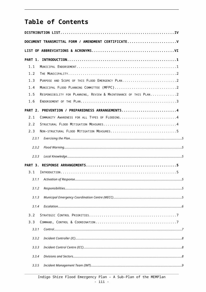
Table of ContentsDISTRIBUTION LIST........................................................................................................................ IV
DOCUMENT TRANSMITTAL FORM / AMENDMENT CERTIFICATE..............................................V
LIST OF ABBREVIATIONS & ACRONYMS.....................................................................................VI
PART 1. INTRODUCTION...............................................................................................................1
1.1 MUNICIPAL ENDORSEMENT....................................................................................................1
1.2 THE MUNICIPALITY................................................................................................................. 2
1.3 PURPOSE AND SCOPE OF THIS FLOOD EMERGENCY PLAN......................................................2
1.4 MUNICIPAL FLOOD PLANNING COMMITTEE (MFPC)................................................................2
1.5 RESPONSIBILITY FOR PLANNING, REVIEW & MAINTENANCE OF THIS PLAN...............................2
1.6 ENDORSEMENT OF THE PLAN.................................................................................................3
PART 2. PREVENTION / PREPAREDNESS ARRANGEMENTS..................................................4
2.1 COMMUNITY AWARENESS FOR ALL TYPES OF FLOODING.........................................................4
2.2 STRUCTURAL FLOOD MITIGATION MEASURES.........................................................................4
2.3 NON-STRUCTURAL FLOOD MITIGATION MEASURES.................................................................5
2.3.1 Exercising the Plan................................................................................................................................5
2.3.2 Flood Warning.......................................................................................................................................5
2.3.3 Local Knowledge...................................................................................................................................5
PART 3. RESPONSE ARRANGEMENTS.......................................................................................5
3.1 INTRODUCTION...................................................................................................................... 5
3.1.1 Activation of Response..........................................................................................................................5
3.1.2 Responsibilities......................................................................................................................................5
3.1.3 Municipal Emergency Coordination Centre (MECC)............................................................................5
3.1.4 Escalation..............................................................................................................................................6
3.2 STRATEGIC CONTROL PRIORITIES..........................................................................................7
3.3 COMMAND, CONTROL & COORDINATION.................................................................................7
3.3.1 Control................................................................................................................................................... 7
3.3.2 Incident Controller (IC)..........................................................................................................................8
3.3.3 Incident Control Centre (ICC)................................................................................................................8
3.3.4 Divisions and Sectors............................................................................................................................8
3.3.5 Incident Management Team (IMT)........................................................................................................9
3.3.6 Emergency Management Team (EMT).................................................................................................9Indigo Shire Flood Emergency Plan – A Sub-Plan of the MEMPlan
- ii -
3.3.7 On Receipt of a Flood Watch / Severe Weather Warning....................................................................9
3.3.8 On Receipt of the First and Subsequent Flood Warnings..................................................................10
3.4 COMMUNITY INFORMATION AND WARNINGS..........................................................................10
3.5 MEDIA COMMUNICATION......................................................................................................11
3.6 (INITIAL) RAPID IMPACT ASSESSMENT...................................................................................11
3.7 PRELIMINARY DEPLOYMENTS...............................................................................................11
3.8 RESPONSE TO FLASH FLOODING..........................................................................................12
3.9 EVACUATION....................................................................................................................... 12
3.10 FLOOD RESCUE................................................................................................................... 13
3.11 AIRCRAFT MANAGEMENT.....................................................................................................13
3.12 RESUPPLY........................................................................................................................... 13
3.13 ESSENTIAL COMMUNITY INFRASTRUCTURE AND PROPERTY PROTECTION..............................13
3.14 DISRUPTION TO SERVICES...................................................................................................14
3.15 ROAD CLOSURES................................................................................................................14
3.16 DAM FAILURE...................................................................................................................... 14
3.17 WASTE WATER RELATED PUBLIC HEALTH ISSUES AND CRITICAL SEWERAGE ASSETS............14
3.18 AFTER ACTION REVIEW.......................................................................................................15
PART 4. EMERGENCY RELIEF AND RECOVERY ARRANGEMENTS......................................16
4.1 GENERAL............................................................................................................................ 16
4.2 EMERGENCY RELIEF............................................................................................................16
4.3 ANIMAL WELFARE................................................................................................................16
4.4 TRANSITION FROM RESPONSE TO RECOVERY.......................................................................16
APPENDIX A - FLOOD THREATS FOR INDIGO SHIRE................................................................17
APPENDIX B - TYPICAL FLOOD PEAK TRAVEL TIMES..............................................................21
APPENDIX C1 – CHILTERN FLOOD EMERGENCY PLAN...........................................................22
APPENDIX C1 – KIEWA RIVER FLOOD EMERGENCY PLAN......................................................26
APPENDIX D - FLOOD EVACUATION ARRANGEMENTS............................................................33
APPENDIX E - FLOOD WARNING SYSTEMS................................................................................38
APPENDIX F – MAPS...................................................................................................................... 41
Indigo Shire Flood Emergency Plan – A Sub-Plan of the MEMPlan- iii -

Distribution List Copy No.
Issue To: Date
Name OrganisationOriginal MEMP Committee Executive Officer
1 Council Office Copy
2 MEMP Committee Chairman
3 MERO
4 Deputy MERO
5 MRM
6 MERC
7 RERC
8 OIC Beechworth Police Station
9 OIC Rutherglen Police Station
10 OIC Chiltern Police Station
11 OIC Yackandandah Police Station
OIC Tangambalanga Police Station
12 Regional Manager
12 VICSES (Beechworth unit)
14 VICSES (Chiltern unit)
15 VICSES (Rutherglen Unit)
16 VICSES (Yackandandah Unit)
17 North East Catchment Management Authority
18 Bureau of Meteorology (Flood Warning)
19 DELWP
20 Parks Victoria
21 Ambulance Victoria (Beechworth Branch)
22 CFA – District 24
24 VicRoads
25 Department of Health and Human Services Wodonga
26 Department of Health Wodonga
27 SP Ausnet
COVER PHOTO:
Flash flooding November 2010 Indigo Shire Community Centre, CHILTERN
Document Transmittal Form / Amendment Certificate
Indigo Shire Flood Emergency Plan – A Sub-Plan of the MEMPlan- iv -

This Municipal Flood Emergency Plan (MFEP) will be amended, maintained and distributed as required by VICSES in consultation with the Indigo Shire.
Suggestions for amendments to this Plan should be forwarded to:
Regional ManagerNorth East RegionVictoria State Emergency Service64 Sydney RoadBenalla, Victoria, 3672
Amendments listed below have been included in this Plan and promulgated to all registered copyholders.
AmendmentNumber
Date ofAmendment
AmendmentEntered By
Summary of Amendment
0.1 15th Jan 2014 Steve Schneider 1st draft
0.2 July 2014 Steve Schneider 1st review – Indigo Shire
0.3 13th Aug 2014 Steve Schneider Added Chiltern flood inundation mapping
0.4 June 2014 Steve Schneider Updated prior to EMP QA gate
0.5 Sept 2014 Steve Schneider Incorporated recommendations from EMP review
0.6 30 Oct 2015 Tim Loffler Amendments based on 2013/14 flood mitigation in Chiltern
0.7 15th Feb 2016 Steve Schneider Incorporated amendments from Shire meeting
This Plan will be published on the VICSES and Indigo Shire websites.
http://www.ses.vic.gov.au/prepare/your-local-flood-information/indigo-shire
http://www.indigoshire.vic.gov.au/What_We_Do/Emergency_management
Indigo Shire Flood Emergency Plan – A Sub-Plan of the MEMPlan- v -
List of Abbreviations & AcronymsThe following abbreviations and acronyms are used in the Plan:
AEP Annual Exceedance Probability
AHD Australian Height Datum (the height of a location above mean sea level in metres)
AIIMS Australasian Inter-service Incident Management System
ARI Average Recurrence Interval
AV Ambulance Victoria
BoM Bureau of Meteorology
CEO Chief Executive Officer
CERA Community Emergency Risk Assessment
CFA Country Fire Authority
CMA Catchment Management Authority
DELWP Department of Environment, Land, Water & Planning
DH Department of Health
DHS Department of Health & Human Services
DoI Department of Infrastructure
EMLO Emergency Management Liaison Officer
EMMV Emergency Management Manual Victoria
EMT Emergency Management Team
EO Executive Officer
FO Floodway Overlay
FWS Flood Warning System
FZ Floodway Zone
IC Incident Controller
ICC Incident Control Centre
IMS Incident Management System
IMT Incident Management Team
LSIO Land Subject to Inundation Overlay
MECC Municipal Emergency Coordination Centre
MEMP Municipal Emergency Management Plan
MEMPC Municipal Emergency Management Planning Committee
MERC Municipal Emergency Response Coordinator
MERO Municipal Emergency Resource Officer
MFB Metropolitan Fire and Emergency Services Board
MRM Municipal Recovery Manager
NECMA North East Catchment Management Authority
PMF Probable Maximum Flood
RCC Regional Control Centre
RDO Regional Duty Officer
REMI Regional Emergency Management Inspector
RERC Regional Emergency Response Coordinator
RERCC Regional Emergency Response Coordination Centre
SBO Special Building Overlay
SCC State Control Centre
SEWS Standard Emergency Warning System
SHERP State Health Emergency Response Plan
SOP Standard Operating Procedure
VicPol Victoria Police
VICSES Victoria State Emergency Service
Indigo Shire Flood Emergency Plan – A Sub-Plan of the MEMPlan- vi -

Part 1. INTRODUCTION
1.1 Municipal EndorsementThis Municipal Flood Emergency Plan (MFEP) has been prepared by VICSES and Indigo Shire and with the authority of the Municipal Emergency Management Planning Committee (MEMPC) pursuant to Section 20 of the Emergency Management Act 1986 (as amended).
The Indigo Shire Municipal Flood Planning Committee has undertaken the following consultations with the Indigo Shire community about the arrangements contained within this plan:
This MFEP is a sub plan to the Indigo Shire Municipal Emergency Management Plan (MEMP), is consistent with the Emergency Management Manual Victoria (EMMV) and the Victoria Flood Management Strategy (DNRE, 1998a), and takes into account the outcomes of the Community Emergency Risk Assessment (CERA) process undertaken by the Municipal Emergency Management Planning Committee (MEMPC).
The Municipal Flood Emergency Plan is consistent with the Regional Flood Emergency Plan and the State Flood Emergency Plan.
This Municipal Flood Emergency Plan is a result of the cooperative efforts of the Indigo Shire Flood Planning Committee (MFPC) and its member agencies.
This Plan is endorsed by the Indigo Shire MEMPC as a sub-plan to the MEMP on 2/8/2016.
Endorsement
…………………………….………………………………………………………………………….…………..
Mayor / Councillor Date
…………………………….………………………………………………………………………….…………..
VICSES Regional Manager Date
Indigo Shire Flood Emergency Plan – A Sub-Plan of the MEMPlan- 1 -

1.2 The MunicipalityAn outline of Indigo Shire in terms of its location, demography and other general matters is provided in the MEMP. An outline of the flood threat is provided in Appendix A of this Plan.
1.3 Purpose and Scope of this Flood Emergency PlanThe purpose of this MFEP is to detail arrangements agreed for the planning, preparedness/prevention, response and recovery from flood incidents within the Indigo Shire
As such, the scope of the Plan is to:
Identify the Flood Risk to Indigo Shire;
Support the implementation of measures to minimise the causes and impacts of flood incidents within the Indigo Shire;
Detail Response and Recovery arrangements including preparedness, Incident Management, Command and Control;
Identify linkages with Local, Regional and State emergency and wider planning arrangements with specific emphasis on those relevant to flood.
1.4 Municipal Flood Planning Sub-Committee (MFPS)Membership of the Indigo Shire Flood Planning Committee (MFPC) will comprise of representatives from the following agencies and organisations:
VICSES Regional Officer – Emergency Management (Chair),
Department of Health & Human Services
Department of Environment, Land, Water & Planning
Indigo Shire,
Victoria Police (MERC),
North East Catchment Management Authority,
North East Water
1.5 Responsibility for Planning, Review & Maintenance of this PlanThis Municipal Flood Emergency Plan must be maintained in order to remain effective.
VICSES through the MEMPC has responsibility for preparing, reviewing, maintaining and distributing this plan.
The MEMPC will ensure the MFEP is reviewed at least once per year and:
- following any new flood study;
- after change in non-structural and/or structural flood mitigation measures;
- after a significant flood event within the Municipality
- whenever the MEMPC identifies a need to review the Plan
to review, and where necessary, amend arrangements and information contained in this Plan.
Indigo Shire Flood Emergency Plan – A Sub-Plan of the MEMPlan- 2 -

The MEMPC shall convene a Municipal Flood Planning Subcommittee if the requirement for significant changes to the MFEP is identified
1.6 Endorsement of the PlanThe MFEP will be circulated to the MFPS to seek acceptance of the draft plan.
Upon acceptance, the plan is forwarded to the MEMPC for endorsement with the recommendation to include the MFEP as a sub-plan of the MEMPlan.
Indigo Shire Flood Emergency Plan – A Sub-Plan of the MEMPlan- 3 -

Part 2. PREVENTION / PREPAREDNESS ARRANGEMENTS
2.1 Community Awareness for all Types of FloodingDetails of this MFEP will be released to the community through local media, the FloodSafe program, and Council website upon formal adoption by Indigo Shire Council.
VICSES with the support of Indigo Shire and in-principal support from North East Catchment Management Authority will coordinate community education programs for flooding within the council area. (E.g. FloodSafe / StormSafe).
2.2 Structural Flood Mitigation MeasuresThe following summary of structural flood mitigation measures exist within the Council area:
2.2.1 Chiltern Flood Study
Based upon the recommendations of the Chiltern Flood Study (2007), structural flood mitigation works were constructed in Chiltern between 2010 and 2012. These works have focussed on the northern Black Dog Creek tributary entering Chiltern near Crawford Street.
The following works upstream of Main Street focus on reducing the incidence and magnitude of flows breaking out of the northern tributary in the vicinity of Kilgour Street to reduce the impact of flooding in Conness Street commercial area, principally upstream of Main Street:
An online retention basin constructed adjacent to Suffolk Street upstream of North Road. This is designed to retard flows from the northern tributary and principally acts to reduce breakout flows in the vicinity of Kilgour Street which subsequently impact on Conness Street. Flows from the southern tributary (via Lake Anderson) are not impacted by the Suffolk Street retention basin and contribute to flooding around and downstream of Main Street.
Northern tributary –Adjacent Crawford Street upstream of Main Street: channel upgrade works and bund walls to reduce flood extent and incidence of breakout flows.
Northern tributary – Kilgour Street: culvert upgrade.
The following works between Park Street and Barkly Street reduce the extent of flooding;
Northern tributary – Park Street: culvert upgrade.
Northern tributary – Channel upgrade works between Park Street / Martins Lane and Chiltern-Rutherglen Road (Conness Street) reduce flood extents. Land to the north of High Street (Park Street, Main Street, Reid Street) remains flood prone due to the influence of a tributary drainage line between Albert Road and Main Street
Northern tributary – Chiltern-Rutherglen Road to Dickson Court: Channel upgrade works and bunding reduce flood extents particularly around Nickless Street and Peake Court.
Southern tributary – Channel upgrade works – Epsom Road to northern tributary.
The current planning scheme overlays (Floodway Overlay and Land Subject to Inundation Overlay) reflect the estimated 1% AEP (100 year ARI) flood extents based on the 2007 flood study, prior to the implementation of works. While the works are designed to largely mitigate 1% AEP flood impacts in the areas identified above, the overlays remain in place in the absence of a detailed hydraulic assessment of the works as implemented. It is of note that Conness Street upstream of Main Street is known to have flooded in November 2010 (prior to implementation of works) but also flooded in February 2012 after the majority of the works upstream of the area had been completed.
Indigo Shire Flood Emergency Plan – A Sub-Plan of the MEMPlan- 4 -

2.3 Non-structural Flood Mitigation Measures
2.3.1 Exercising the Plan
Arrangements for exercising this Plan will be at the discretion of the MEMPC. This Plan should be regularly exercised, preferably on an annual basis. Refer to section 4.7 of the EMMV for guidance.
2.3.2 Flood Warning
Arrangements for flood warning are contained within the State Flood Emergency Plan and the EMMV (Part 3.7) and on the BoM website.
Specific details of local flood warning system arrangements are provided in appendix E.
2.3.3 Local Knowledge
The VICSES Local Knowledge Policy outlines the strategies and principles for ensuring the incorporation of local knowledge in decision making before, during and after incidents.
Specific details of arrangements are provided in Appendix G of this plan.
Part 3. RESPONSE ARRANGEMENTS
3.1 Introduction
3.1.1 Activation of Response
Flood response arrangements may be activated by the Regional Duty Officer (RDO) VICSES North East Region or Incident Controller (IC).
The Incident Controller (IC) / RDO VICSES will activate agencies as required and documented in the State Flood Emergency Management Plan.
3.1.2 Responsibilities
There are a number of agencies with specific roles that will act in support of VICSES and provide support to the community in the event of a serious flood within the Indigo Shire. These agencies will be engaged through the EMT (Emergency Management Team).
The general roles and responsibilities of supporting agencies are as agreed within the Indigo Shire MEMP, EMMV (Part 7 ‘Emergency Management Agency Roles’), State Flood Emergency Plan and Regional Flood Emergency Plan.
3.1.3 Municipal Emergency Coordination Centre (MECC)
Liaison with the MECC will be through the established Division/Sector Command and through Municipal involvement in the Incident EMT, in particular the Municipal Emergency Response Coordinator (MERC). The VICSES RDO / ICC will liaise with the MECC directly if no Division/Sector Command is established.
The function, location, establishment and operation of the MECC will be as detailed in the Indigo Shire MEMP.
Indigo Shire Flood Emergency Plan – A Sub-Plan of the MEMPlan- 5 -

3.1.4 Escalation
Most flood incidents are of local concern and an appropriate response can usually be coordinated using local resources. However, when these resources are exhausted, the State’s arrangements provide for further resources to be made available, firstly from neighbouring Municipalities (on a regional basis) and then on a State-wide basis.
Resourcing and event escalation arrangements are described in the EMMV (‘State Emergency Response Plan’ – section 3.5).
Indigo Shire Flood Emergency Plan – A Sub-Plan of the MEMPlan- 6 -

3.2 Strategic Control PrioritiesTo provide guidance to the Incident Management Team (IMT), the following strategic control priorities shall form the basis of incident action planning processes:
1. Protection and preservation of life is paramount - this includes:
a. Safety of emergency services personnel, and;
b. Safety of community members including vulnerable community members and visitors/tourist located within the incident area.
2. Issuing of community information and community warnings detailing incident information that is timely, relevant and tailored to assist community members make informed decisions about their safety.;
3. Protection of critical infrastructure and community assets that supports community resilience;
4. Protection of residential property as a place of primary residence;
5. Protection of assets supporting individual livelihoods and economic production that supports individual and community financial sustainability
6. Protection of environmental and conservation values that considers the cultural, biodiversity, and social values of the environment;
Circumstances may arise where the Incident Controller is required to vary these priorities, with the exception being that the protection of life should remain the highest. This shall be done in consultation with the State Controller and relevant stakeholders based on sound incident predictions and risk assessments.
3.3 Command, Control & CoordinationThe Command, Control and Coordination arrangements in this Municipal Flood Emergency Plan must be consistent with those detailed in State and Regional Flood Emergency Plans. For further information, refer to sections 3.4, 3.5 & 3.6 of the EMMV.
The specific details of the Command, Control and Coordination arrangements for this plan are provided in Appendix C.
3.3.1 Control
Functions 5(a) and 5(c) at Part 2 of the Victoria State Emergency Service Act 1986 (as amended) detail the authority for VICSES to plan for and respond to flood.
Part 7.1 of the EMMV prepared under the Emergency Management Act 1986 (as amended), identifies VICSES as the Control Agency for flood. It identifies DELWP as the Control Agency responsible for “dam safety, water and sewerage asset related incidents” and other emergencies
All flood response activities within the Indigo Shire including those arising from a dam failure or retarding basin / levee bank failure incident will therefore be under the control of the appointed Incident Controller, or his / her delegated representative.
Indigo Shire Flood Emergency Plan – A Sub-Plan of the MEMPlan- 7 -

3.3.2 Incident Controller (IC)
An Incident Controller (IC) will be appointed by the VICSES (as the Control Agency) to command and control available resources in response to a flood event on the advice of the Bureau of Meteorology (or other reliable source) that a flood event will occur or is occurring. The Incident Controller responsibilities are as defined in Part 3.5 of the EMMV
3.3.3 Incident Control Centre (ICC)
As required, the Incident Controller will establish an Incident Control Centre (ICC) from which to initiate incident response command and control functions. The decision as to if and when the ICC should be activated, rests with the Control Agency (i.e. VICSES).
Pre-determined Incident Control Centre locations are
Primary Facility
Location Wangaratta
Owner CFA District 23 Headquarters
Address 1 Ely Street Wangaratta
Secondary Facilities
Location Wodonga
Owner CFA District 24 Headquarters
Address 55 Moorefield Park Drive, West Wodonga
Location Benalla
Owner VICSSES Hume Regional Office
Address 64 Sydney Road Benalla
3.3.4 Divisions and Sectors
To ensure that effective Command and Control are in place, the Incident Controller may establish Divisions and Sectors depending upon the complexity of the event and resource capacities.
The following Divisions and Sectors may be established:
Division SectorYackandandah Mt Beauty CFA,
Towonga CFA,Kiewa CFAChiltern SESRutherglen SESBeechworth SESYackandandah SES
Indigo Shire Flood Emergency Plan – A Sub-Plan of the MEMPlan- 8 -

3.3.5 Incident Management Team (IMT)
The Incident Controller will form an Incident Management Team (IMT).
Refer to 3.5 of the EMMV for guidance on IMTs and Incident Management Systems (IMSs).
3.3.6 Emergency Management Team (EMT)
The Incident Controller will establish a multi-agency Emergency Management Team (EMT) to assist the flood response. The EMT will consist of key personnel (with appropriate authority) from stakeholder agencies and relevant organisations who need to be informed of strategic issues related to incident control and who are able to provide high level strategic guidance and policy advice to the Incident Controller for consideration in developing incident management strategies.
Organisations, including Indigo Shire required within the EMT will provide an Emergency Management Liaison Officer (EMLO) to the ICC if and as required as well as other staff and / or resources identified as being necessary, within the capacity of the organisation.
Refer to 3.5 of the EMMV for guidance on EMTs.
3.3.7 On Receipt of a Flood Watch / Severe Weather Warning
Incident Controller or VICSES RDO (until an incident controller is appointed) will undertake actions as defined within the flood intelligence cards (appendix C). General considerations by the Incident Controller/VICSES RDO will be as follows:
Review flood intelligence to assess likely flood consequences
Monitor weather and flood information – www.bom.gov.au
Assess Command and Control requirements.
Review local resources and consider needs for further resources regarding personnel, property protection, flood rescue and air support
Notify and brief appropriate officers. This includes Regional Control Centre (RCC) (if established), State Control Centre (SCC) (if established), Council, other emergency services through the EMT.
Assess ICC readiness (including staffing of IMT and EMT) and open if required
Ensure flood bulletins and community information are prepared and issued to the community
Monitor watercourses and undertake reconnaissance of low-lying areas
Develop media and community information management strategy
Ensure flood mitigation works are being checked by owners
Develop, issue and maintain incident action plan (IAP), if required
Develop and issue situation reports (Sitreps), if and as required
Indigo Shire Flood Emergency Plan – A Sub-Plan of the MEMPlan- 9 -

3.3.8 On Receipt of the First and Subsequent Flood Warnings
Incident Controller/VICSES RDO (until an incident controller is appointed) will undertake actions as defined within the flood intelligence cards (appendix C). General considerations by the Incident Controller/VICSES RDO will be as follows:
Develop an appreciation of current flood levels and predicted levels. Are floodwaters, rising, peaking or falling?
Review flood intelligence to assess likely flood consequences. Consider:
What areas may be at risk of inundation
What areas may be at risk of isolation
What areas may be at risk of indirect affects as a consequence of power, gas, water, telephone, sewerage, health, transport or emergency service infrastructure interruption
The characteristics of the populations at risk
Determine what the at-risk community need to know and do as the flood develops.
Warn the at-risk community including ensuring that an appropriate warning and community information strategy is implemented including details of:
The current flood situation
Flood predictions
What the consequences of predicted levels may be
Public safety advice
Who to contact for further information
Who to contact for emergency assistance
Liaise with relevant asset owners as appropriate (i.e. water and power utilities)
Implement response strategies as required based upon flood consequence assessment.
Continue to monitor the flood situation – www.bom.gov.au/vic/flood/
Continue to conduct reconnaissance of low-lying areas
3.4 Community Information and WarningsGuidelines for the distribution of community information and warnings are contained in the State Flood Emergency Plan.
Community information and warnings communication methods available include:
Emergency Alert;
Phone messages (including SMS);
Radio and Television;
Two-way radio;
Mobile and fixed public address systems;
Sirens;
Verbal Messages (i.e. Doorknocking);
Agency Websites;
Indigo Shire Flood Emergency Plan – A Sub-Plan of the MEMPlan- 10 -

VICSES Flood Storm Information Line;
Variable Message Signs (i.e. road signs);
Community meetings;
Newspapers;
Email;
Telephone trees;
Community Flood Wardens;
Newsletters;
Letter drops;
Social media and/or social networking sites (i.e. twitter and/or Facebook).
Refer to Appendix C and E for the specific details of how community information and warnings are to be provided.
The release of flood bulletins and information with regard to response activities at the time of a flood event is the responsibility of VICSES as the Control Agency.
Responsibility for public information, including media briefings, rest with VICSES as the Control Agency. Council will support VICSES with local knowledge and assistance
Other agencies such as CFA, DELWP and VICPOL may be requested to assist VICSES with the communication of community flood warnings.
In cases where severe flash flooding is predicted, dam failure is likely or flooding necessitating evacuation of communities is predicted, the Incident Controller may consider the use of the Emergency Alert System and Standard Emergency Warning System (SEWS).
3.5 Media CommunicationThe Incident Controller through the Information Unit established at the ICC will manage Media communication. If the ICC is not established the RDO will manage all media communication.
3.6 (Initial) Rapid impact assessmentA rapid impact assessment (RIA) can be conducted to assess and record the extent and nature of damage caused by flooding. This information may then be used to provide the basis for further needs assessment and recovery planning by DHS and recovery agencies.
Victoria Police is responsible for coordinating the collection, collation and dissemination of RIA information on a whole-of government basis. The Incident Controller is responsible for activating Victoria Police to undertake this function.
The purpose, function and conduct of RIAs are outlined in the State Flood Emergency Plan. All RIAs should be conducted in accordance with Part 3 of the EMMV.
3.7 Preliminary DeploymentsWhen flooding is expected to be severe enough to cut access to towns, suburbs and/or communities the Incident Controller will consult with relevant agencies to ensure that resources are in place if required to provide emergency response. These resources might include emergency
Indigo Shire Flood Emergency Plan – A Sub-Plan of the MEMPlan- 11 -

service personnel, food items and non-food items such as medical supplies, shelter, assembly areas, relief centres etc.
3.8 Response to Flash FloodingEmergency management response to flash flooding should be consistent with the guideline for the emergency management of flash flooding contained within the State Flood Emergency Plan.
When conducting pre-event planning for flash floods the following steps should be followed, and in the order as given:
1. Determine if there are barriers to evacuation by considering warning time, safe routes, resources available;
2. If evacuation is possible, then evacuation should be the adopted strategy and it must be supported by a public information capability and a rescue contingency plan;
3. Where it is likely people will become trapped by floodwaters due to limited evacuation options safety advice needs to be provided to people at risk advising them not to attempt to flee by entering floodwater if they become trapped, and that it may be safer to seek the highest point within the building and to telephone 000 if they require rescue. This advice needs to be provided even when evacuation may be possible, due the likelihood that not all community members will evacuate.
4. For buildings known to be structurally un-suitable an earlier evacuation trigger will need to be established (return to step 1 of this cycle).
5. If an earlier evacuation is not possible then specific preparations must be made to rescue occupants trapped in structurally unsuitable buildings either pre-emptively or as those people call for help.
During a flash flood it will often be difficult, due the rapid development of flooding, to establish evacuation (relief) centres ahead of actually triggering the evacuation as is normal practice but this is insufficient justification for not adopting evacuation.
3.9 EvacuationIn Victoria, evacuation is largely voluntary. However, in particular circumstances, legislation provides some emergency service personnel with authority to remove people from areas or prohibit their entry.
The decision to recommend or warn people to prepare to evacuate or to evacuate immediately rests with the Incident Controller.
It is the choice of individuals as to how they respond to this recommendation.
Once the decision is made, Victoria Police are responsible for the management of the evacuation process where possible. VICSES and other agencies will assist where practical. VICSES is responsible for the development and communication of evacuation warnings.
Victoria Police and / or Australian Red Cross are responsible for registering people affected by a flood emergency including those who have been evacuated.
Refer to Section 3.8 of the EMMV and the Evacuation Guidelines for guidance on evacuations for flood emergencies.
Refer to Appendix D of this MFEP for detailed evacuation arrangements in the event of flooding.
Indigo Shire Flood Emergency Plan – A Sub-Plan of the MEMPlan- 12 -

3.10 Flood RescueVICSES may conduct flood rescues. Appropriately trained and equipped VICSES units or other agencies that have appropriate training, equipment and support may carry out rescues.
Rescue operations may be undertaken where voluntary evacuation is not possible, has failed or is considered too dangerous for an at-risk person or community. An assessment of available flood rescue resources (if not already done prior to the event) should be undertaken prior to the commencement of Rescue operations.
Rescue is considered a high-risk strategy to both rescuers and persons requiring rescue and should not be regarded as a preferred emergency management strategy. Rescuers should always undertake a dynamic risk assessment before attempting to undertake a flood rescue.
3.11 Aircraft ManagementAircraft can be used for a variety of purposes during flood operations including evacuation, resupply, reconnaissance, intelligence gathering and emergency travel.
Air support operations will be conducted under the control of the Incident Controller.
The Incident Controller may request aircraft support through the State Air Desk located at the State Control Centre (SCC). The SCC will establish priorities.
3.12 ResupplyCommunities, neighbourhoods or households can become isolated during floods as a consequence of road closures or damage to roads, bridges and causeways. Under such circumstances, the need may arise to resupply isolated communities/properties with essential items.
When predictions/intelligence indicates that communities, neighbourhoods and/or households may become isolated, VICSES will advise businesses and/or households that they should stock up on essential items.
After the impact, VICSES can support isolated communities through assisting with the transport of essential items to isolated communities and assisting with logistics functions.
Resupply operations are to be included as part of the emergency relief arrangements with VICSES working with the relief agencies to service communities that are isolated.
3.13 Essential Community Infrastructure and Property ProtectionEssential Community Infrastructure and Property (e.g. residences, businesses, roads, power supply etc.) may be affected in the event of a flood.
The Indigo Shire maintains a small stock of sandbags to protect those assets, which are the statutory responsibility of Council, and back-up supplies are available through the VICSES Regional Headquarters. The Incident Controller will determine the priorities related the use of sandbags, which will be consistent with the strategic priorities.
If VICSES sandbags are becoming limited in supply, then priority will be given to protection of Essential Community Infrastructure. Other high priorities may include for example the protection of historical buildings.
Property may be protected by:
Sandbagging to minimise entry of water into buildings Encouraging businesses and households to lift or move contents Construction of temporary levees in consultation with the CMA, LGA and VICPOL and within appropriate approval frameworks.
Indigo Shire Flood Emergency Plan – A Sub-Plan of the MEMPlan- 13 -

The Incident Controller will ensure that owners of Essential Community Infrastructure are kept advised of the flood situation. Essential Community Infrastructure providers must keep the Incident Controller informed of their status and ongoing ability to provide services.
3.14 Disruption to ServicesDisruption to services other than essential community infrastructure and property can occur in flood events. Refer to appendix C for specific details of likely disruption to services and proposed arrangements to respond to service disruptions in Indigo Shire.
3.15 Road ClosuresVicRoads are responsible for designated main roads and highways. Council are responsible for the designated local road network.
Road closures caused by flooding within the Municipality will be managed by Indigo Shire and VicRoads as part of their normal formal functions. This will include necessary observations and the placement of warning signs, road blocks etc. to local and regional roads, bridges, walking and bike trails etc. Indigo Shire staff may also liaise with and advise VicRoads as to the need or advisability of erecting warning signs and / or of closing roads and bridges under its jurisdiction.
VicRoads and Indigo Shire will communicate information regarding road closures to the ICC. The VicRoads website will be updated and maintained for current road closures. www.vicroads.vic.gov.au
3.16 Dam FailureDELWP is the Control Agency for dam safety incidents (e.g. breach, failure or potential breach / failure of a dam), however VICSES is the Control Agency for any flooding that may result.
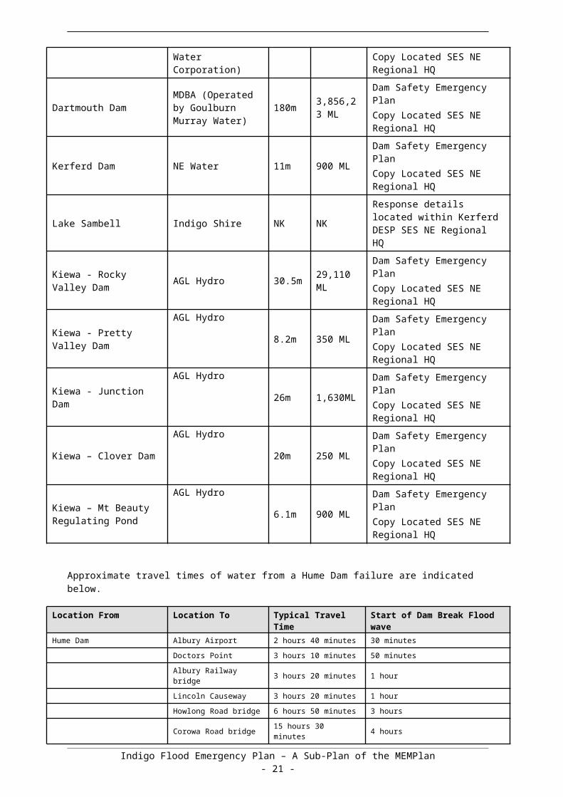
Appendix A contains lists of the dams in or adjacent to Indigo Shire
3.17 Waste Water related Public Health Issues and Critical Sewerage Assets
Inundation of critical sewerage assets including septic tanks and sewerage pump stations may result in water quality problems within the Municipality. Where this is likely to occur or has occurred the responsible agency for the critical sewerage asset should undertake the following:
Advise VICSES of the security of critical sewerage assets to assist preparedness and response activities in the event of flood;
Maintain or improve the security of critical sewerage assets;
Check and correct where possible the operation of critical sewerage assets in times of flood;
Advise the ICC in the event of inundation of critical sewerage assets.
It is the responsibility of the Indigo Shire Environmental Health Officer to inspect and report to the MERO and the ICC on any water quality issues relating to flooding.
3.18 After Action Review VICSES will coordinate the after action review arrangements of flood operations as soon as practical following an event.
All agencies involved in the flood incident should be represented at the after action review.
Indigo Shire Flood Emergency Plan – A Sub-Plan of the MEMPlan- 14 -

Part 4. EMERGENCY RELIEF AND RECOVERY ARRANGEMENTS
4.1 GeneralArrangements for recovery from a flood incident within the Indigo Shire are detailed in the Indigo Shire MEMP.
4.2 Emergency ReliefThe Incident Controller will ensure that the MERC, the Regional Recovery Coordinator and the Municipal Recovery Manager are kept informed of the need for relief.
The decision to recommend the opening of an emergency relief centre rests with the Incident Controller. Incident Controllers are responsible for ensuring that relief arrangements have been considered and implemented where required under the State Emergency Relief and Recovery Plan (Part 4 of the EMMV).
The range and type of emergency relief services to be provided in response to a flood event will be dependent upon size, impact, and scale of the flood. Refer to Section 4.4 of EMMV for details of the range of emergency relief services that may be provided.
Suitable relief facilities identified for use during floods, including details of relief arrangements, are detailed in the MEMP.
4.3 Animal WelfareAnimal management guidelines are provided in the MEMP along with the location and contact details for appropriate animal welfare entities.
Matters relating to the welfare of livestock, companion animals and wildlife (including feeding and rescue) are to be referred to DELWP. This includes requests for emergency supply and / or delivery of fodder to stranded livestock or for livestock rescue.
Matters relating to the welfare of wildlife are to be referred to DELWP.
Refer to the Indigo Shire MEMP Plan and Animal Welfare Plan for animal shelter compound locations.
4.4 Transition from Response to RecoveryVICSES as the Control Agency is responsible for ensuring effective transition from response to recovery. This transition will be conducted in accordance with existing arrangements as detailed in Part 3 Section 3.10 of the EMMV.
Indigo Flood Emergency Plan – A Sub-Plan of the MEMPlan- 15 -
APPENDIX A - FLOOD THREATS FOR INDIGO SHIRE The Indigo Shire is a rural based Municipality situated adjacent the Murray River and includes the Indigo Creek and Black Dog Creek catchments (draining to the Murray River) and extending to the middle reaches of the Kiewa River (including the Yackandandah Creek catchment). The major population centres of the Shire are Rutherglen, Chiltern, Yackandandah and Beechworth.
The Shire is approximately 270 km northeast of Melbourne, on the Hume freeway.
Adjacent Municipalities are the Towong Shire to the East, the City of Wodonga to the North East, Alpine Shire to the south-east, the Rural City of Wangaratta to the South, the Moira Shire to the West with the Murray river forming part of the Northern boundary.
The Shire’s economy is based on tourism and value adding to the agricultural produce of the region, milk, cereals and grapes provide the foremost opportunities.
Many people in the Shire commute to Wodonga and Wangaratta for employment.
General/ TopographyThe northern part of the municipality (approximately north-west of Mt Pilot) encompasses the Black Dog Creek catchment with a slight fall of approximately 1 in 5000 to the northwest apart from localised insertions by present or past streams. The central and eastern part of the municipality includes the elevated land around Beechworth and Yackandandah, falling to the Kiewa River floodplain in the eastern part of the municipality.
Significant bodies of water within or bordering the Shire are:
The Murray River forming part of the northern boundary. The Hume Dam situated adjacent to Tangambalanga/ Huon areas in the eastern part of the
Shire. The Kiewa River passes through Kergunyah and Kiewa townships also to the east of the Shire. The Kerferd Dam is located approximately 5 kilometres upstream of Beechworth.
There are no significant dams or reservoirs upstream of Lake Kerferd.
Inflows to Lake Kerferd are augmented from neighbouring Nine Mile Creek by a system of weirs, channels and tunnels.
Historic Floods
The history of flood events in relation to the Murray, Ovens and Kiewa rivers is well documented in municipal and Water authority records and reports indicated the level of impact on the Municipal area of the Indigo Shire from previous flood events.
The Shire was impacted significantly by the flood events of 2010-2012 as was the case with many council areas across Northern Victoria during that time.
Chiltern experienced the most significant flood damage in the Shire during this period.
Description of Major Waterways and DrainsThe table below details the major waterways which impact Indigo Shire.
Indigo Flood Emergency Plan – A Sub-Plan of the MEMPlan- 16 -
Waterway or Drain
Description
Black Dog Creek and tributaries
Black Dog Creek rises in the hills to the south-east of Chiltern in the Chiltern-Mt Pilot National Park. It flows from south to north through the western end of Chiltern township. To the south-west of Chiltern it flows under the Hume Freeway and then under the railway line and McKay street further to the north. The catchment area of Black Dog Creek upstream of Chiltern is approximately 179 km2. Further downstream Black Dog Creek goes on to flow into the Murray River 14 km downstream of Corowa.
Several small tributaries flow from the hills to the east, north-east and north of Chiltern and then through the township. The largest of these is broadly referred to as the northern streamlines in this document and the Chiltern Flood Study. The northern streamline flows from east to west to the north of main street adjacent to High Street and Crawford Street.
No river gauges exist on Black Dog Creek or the smaller tributaries which flow through Chiltern. Due to the relatively small catchments involved, flooding in Chiltern typically occurs within 1 to 3 hours of the start of the rainfall event.
Murray River
The Murray River forms the northern border of Indigo Shire and flows from east to west past a number of townships including Wodonga (upstream of Indigo Shire), Howlong and Wahgunyah. The Murray River has large areas of floodplain within the municipality that are inundated on a regular basis. Inundation through this area can be influenced significantly by releases from Hume Dam and unregulated flows from the Kiewa River.
Stream-flow gauges are located at Corowa (409002) and further upstream at Doctors Point (409017) near Wodonga. Hume Dam, also has gauges recording both storage level and flow data.
Kiewa River and Yackandandah Creek
A section of the Kiewa River is located within the Indigo Shire area. The Kiewa River rises in the Victorian Alps around Mount Beauty and flows into the Murray River just upstream of Wodonga. The small townships of Kiewa, Kergunyah and Tangambalanga lie on the Kiewa River within the Indigo Shire area.
Yackandandah Creek is a major tributary of the Kiewa River and rises in the hills to the south-west of Yackandandah. It flows through Yackandandah township and then into the Kiewa River approximately 6 km downstream of Tangambalanga.
Three fully telemetered stream-flow gauges are located on the Kiewa River at Mongan’s Bridge, Kiewa and Bandiana. All three gauges have flood class levels and are utilised by the Bureau of Meteorology for flood forecasting. An additional telemetered gauge also exists on Yackandandah Creek at Yackandandah however it has no flood class levels.
Indigo Creek
Indigo Creek rises in the hills to the north of Yackandandah, and flows to the north-west, through the township of Barnawartha. It goes on to flow into the Murray River 10 km upstream of Howlong.
A stream-flow gauge exists on Indigo Creek at Creamery Bridge (403248), located immediately upstream of its outlet into the Murray River but does not form part of the flood warning system.
Indigo Flood Emergency Plan – A Sub-Plan of the MEMPlan- 17 -
Dam FailureDELWP has regulatory responsibilities for dam safety within Victoria and maintains a database of dams managed by water authorities. Requirements for dam safety are set out in the DELWP document: -Strategic Framework for Dam Safety Regulation. Large private dams are licensed and Dam Safety Emergency Plans are required under the licence.
Flooding resulting from failure of the following dams within t he shire or the catchments above the shire is likely to cause significant structural and community damage within the Indigo Shire.
Location Owner Dam Height
Dam Capacity
Comments
Hume DamMDBA (operated by NSW State Water Corporation)
51m 3,005,157 ML
Dam Safety Emergency PlanCopy Located SES NE Regional HQ
Dartmouth DamMDBA (Operated by Goulburn Murray Water)
180m 3,856,23 ML
Dam Safety Emergency PlanCopy Located SES NE Regional HQ
Kerferd Dam NE Water 11m 900 MLDam Safety Emergency PlanCopy Located SES NE Regional HQ
Lake Sambell Indigo Shire NK NKResponse details located within Kerferd DESP SES NE Regional HQ
Kiewa - Rocky Valley Dam AGL Hydro 30.5m 29,110
ML
Dam Safety Emergency PlanCopy Located SES NE Regional HQ
Kiewa - Pretty Valley Dam
AGL Hydro8.2m 350 ML
Dam Safety Emergency PlanCopy Located SES NE Regional HQ
Kiewa - Junction DamAGL Hydro
26m 1,630MLDam Safety Emergency PlanCopy Located SES NE Regional HQ
Kiewa – Clover DamAGL Hydro
20m 250 MLDam Safety Emergency PlanCopy Located SES NE Regional HQ
Kiewa – Mt Beauty Regulating Pond
AGL Hydro6.1m 900 ML
Dam Safety Emergency PlanCopy Located SES NE Regional HQ
Approximate travel times of water from a Hume Dam failure are indicated below.
Location From Location To Typical Travel Time Start of Dam Break Flood waveHume Dam Albury Airport 2 hours 40 minutes 30 minutes
Doctors Point 3 hours 10 minutes 50 minutes
Albury Railway bridge 3 hours 20 minutes 1 hour
Lincoln Causeway 3 hours 20 minutes 1 hour
Howlong Road bridge 6 hours 50 minutes 3 hours
Corowa Road bridge 15 hours 30 minutes 4 hours
Indigo Flood Emergency Plan – A Sub-Plan of the MEMPlan- 18 -

Flood Mitigation
Overview of Levees within the MunicipalityThe Victorian Flood Database identifies a number of levees along the Kiewa River and Yackandandah Creek within the Indigo municipality. A number of these levees are roads. The North East CMA Strategic Levee Audit (Water Technology, 2013) surveyed a number of the levees along the Kiewa within the municipality. The levees protect rural land and are not part of a formal flood mitigation scheme. This study found that close to 60% of strategic levees surveyed were located on private land and 40% of the levee surveyed had a crest level below the 1998 flood level. The study identified 1 high risk site near the Kiewa East Road crossing for priority works, with the majority of the surveyed levee having a low to medium risk.
Indigo Flood Emergency Plan – A Sub-Plan of the MEMPlan- 19 -

APPENDIX B - TYPICAL FLOOD PEAK TRAVEL TIMES Definitive information on the time it takes rainfall associated with severe weather or thunderstorm activity to develop into runoff and therefore streamflow is highly dependent on antecedent conditions.
A flood on a ‘dry’ watercourse will generally travel more slowly than a flood on a ‘wet’ watercourse (e.g. the first flood after a dry period will travel more slowly than the second flood in a series of floods) and big floods tend to travel faster than small floods. Hence, the size of the flood, recent flood history, soil moisture and forecast weather conditions all need to be considered when using the following information to direct flood response activities.
Travel times are calculated as the time that the peak of the event takes to move from one gauge to the next. Note that the onset of flooding can occur before the peak water level occurs. Travel times are only displayed for major rivers, where more than one flood warning gauge exists. Other streamflow gauges, historic flood reports, and CMA/DELWP knowledge should be used for additional travel time information where flood warning gauges are not available.
Kiewa River floods
Reach September 2010 September 1998 October 1993
Kiewa River at Mongans
Bridge- - -
Kiewa River at (Mainbranch) 16hrs 11hrs 17.5hrs
Kiewa River at Bandiana 23hrs 17.5hrs 26.5hrs
Murray River floods
Reach October 2000 October 1996 October 1992
Murray River at Heywoods - - -
Murray River at Albury 11.5hrs 5hrs 7hrs
Indigo Flood Emergency Plan – A Sub-Plan of the MEMPlan- 20 -

APPENDIX C1 – CHILTERN FLOOD EMERGENCY PLAN The township of Chiltern lies adjacent to the Hume Freeway, 25 km west of Albury and 35 km north-east of Wangaratta. Black Dog Creek runs through the western end of the township, and has an upstream catchment area of approximately 179 km2. The following map shows the catchment area upstream of Chiltern. A number of small tributaries rise from the hills to the east and north of Chiltern and flow through the centre of the township.
Flooding patterns through the Chiltern Township are complex and are the result of flooding in three separate tributaries of Black Dog Creek. Over the previous decades works has been undertaken to divert water away from an old course of the creek that would naturally have crossed Conness St. These works provide a measure of protection; however beyond this level of protection flooding of various properties will occur in a flood event.
The community of Chiltern has experienced flooding several times in recent years including February 2012, November 2010 and September 2005. In the September 2005 event Conness Street was inundated up to depths of one metre and numerous properties were flooded. Following the 2005 event the Chiltern Flood Study (2007) was commissioned. The flood study considered a number of structural mitigation options including an upstream retarding basin. Flood mitigation works, based on the 2007 Flood Study, were implemented along the northern drainage line between 2010 and 2012. An outline of these works is provided in Section 2.2 and in the figure below. The works are designed to mitigate flood risks up to the 1% AEP flood level however localised flood risk remains. The current planning scheme overlays conservatively represent the flood risk in the absence of the implemented mitigation works in the absence of a detailed hydraulic assessment of the works as implemented.
Potential flood damage in Chiltern is exacerbated by the quick catchment response (~1 hour) meaning that there is little opportunity for flood warning which in other circumstances would enable property owners to take measures to avoid flood damage.
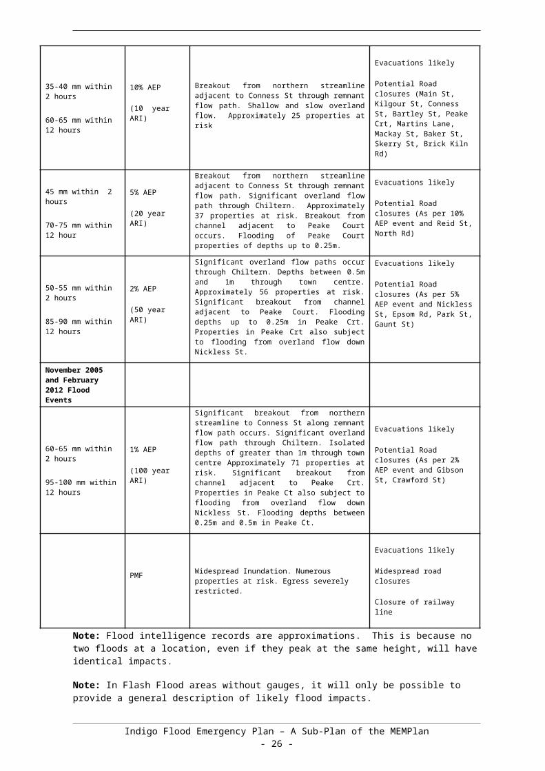
Rainfall Data 60-65 mm within 2 hrs
95-100 mm within 12 hrs
1% AEP event (100 year ARI event)Significant breakout from northern streamline to Conness St occurs. Significant overland flow path through Chiltern. Isolated depths of greater than 1m through town centre. Approximately 71 properties at risk. Significant breakout from channel adjacent to Peake Court. Properties in Peake Court also subject to flooding from overland flow down Nickless St. Flooding depths between 0.25 m and 0.5 m in Peake Ct.
November 2005 and February 2012 Flood Events50-55 mm within 2 hrs
85-90 mm within 12 hrs
2% AEP event (50 year ARI event)Significant overland flow paths occur through Chiltern. Depths between 0.5 m and 1 m through town centre. Approximately 56 properties at risk. Significant breakout from channel adjacent to Peake Court. Flooding depths up to 0.25 m in Peake Court. Properties in Peake Court also subject to flooding from overland flow down Nickless St.
45 mm within 2 hrs
70-75 mm within 12 hrs
5% AEP event (20 year ARI event)Breakout from northern streamline adjacent to Conness St through remnant flow path. Significant overland flow path through Chiltern. Approximately 37 properties at risk. Breakout from channel adjacent to Peake Court occurs. Flooding of Peake Court properties of depths up to 0.25 m.
35-40 mm within 2 hrs
60-65 mm within 12 hrs
10% AEP event (10 year ARI event)Breakout from northern streamline adjacent to Conness St. Shallow depths, flowing slowly overland. Approximately 25 properties at risk.
30-35 mm within 2 hrs
55-60 mm within 12 hrs
20% AEP event (5 year ARI event)Very shallow, slow overland flow.
* Flood impacts as described reflect the assessed flood risk based on the 2007 Flood Study. Implementation of flood mitigation works (2010-2012) have reduced risk / impact but in the absence of hydraulic assessment of works, impacts outlined above provide a conservative summary of likely flood impacts.
Indigo Flood Emergency Plan – A Sub-Plan of the MEMPlan- 21 -

Other Control StructuresThe bridges over Black Dog Creek at Mackay St and the railway line should be monitored during a flood event to ensure that these bridges are not blocked by debris. Culverts in the central township should also be monitored.
Flood Impacts and Required ActionsThe Table below provides an overview of the consequences of flooding based on various ARI events.
River Height (m)And orRiver Flow (ML/d)And orRainfall (mm/hr)
Annual Exceedance Probability
Consequence / Impact ActionActions may include (but not limited to) Evacuation, closure of road, sandbagging, issue warning and who is responsible
30-35 mm within 2 hours
55-60 mm within 12 hours
20% AEP
(5 year ARI)
Very shallow, slow overland flow.Monitor the situation. If further rises are likely warn residents and prepare for evacuations.
35-40 mm within 2 hours
60-65 mm within 12 hours
10% AEP
(10 year ARI)
Breakout from northern streamline adjacent to Conness St through remnant flow path. Shallow and slow overland flow. Approximately 25 properties at risk
Evacuations likely
Potential Road closures (Main St, Kilgour St, Conness St, Bartley St, Peake Crt, Martins Lane, Mackay St, Baker St, Skerry St, Brick Kiln Rd)
45 mm within 2 hours
70-75 mm within 12 hour
5% AEP
(20 year ARI)
Breakout from northern streamline adjacent to Conness St through remnant flow path. Significant overland flow path through Chiltern. Approximately 37 properties at risk. Breakout from channel adjacent to Peake Court occurs. Flooding of Peake Court properties of depths up to 0.25m.
Evacuations likely
Potential Road closures (As per 10% AEP event and Reid St, North Rd)
50-55 mm within 2 hours
85-90 mm within 12 hours
2% AEP
(50 year ARI)
Significant overland flow paths occur through Chiltern. Depths between 0.5m and 1m through town centre. Approximately 56 properties at risk. Significant breakout from channel adjacent to Peake Court. Flooding depths up to 0.25m in Peake Crt. Properties in Peake Crt also subject to flooding from overland flow down Nickless St.
Evacuations likely
Potential Road closures (As per 5% AEP event and Nickless St, Epsom Rd, Park St, Gaunt St)
November 2005 and February 2012 Flood Events
60-65 mm within 2 hours
95-100 mm within 12 hours
1% AEP
(100 year ARI)
Significant breakout from northern streamline to Conness St along remnant flow path occurs. Significant overland flow path through Chiltern. Isolated depths of greater than 1m through town centre Approximately 71 properties at risk. Significant breakout from channel adjacent to Peake Crt. Properties in Peake Ct also subject to flooding from overland flow down Nickless St. Flooding depths between 0.25m and 0.5m in Peake Ct.
Evacuations likely
Potential Road closures (As per 2% AEP event and Gibson St, Crawford St)
PMF Widespread Inundation. Numerous properties at risk. Egress severely restricted.
Evacuations likely
Widespread road closures
Closure of railway line
Indigo Flood Emergency Plan – A Sub-Plan of the MEMPlan- 22 -
Note: Flood intelligence records are approximations. This is because no two floods at a location, even if they peak at the same height, will have identical impacts.
Note: In Flash Flood areas without gauges, it will only be possible to provide a general description of likely flood impacts.
Overview of Flooding Consequences
Warning Times
The catchment response time at Chiltern (i.e. the time between rainfall and flood) is only in the order of 1 hour thus by definition (Bureau of Meteorology, 1996), the township is subject to flash flooding as response time is less than 6 hours.
Due to Chiltern’s location in the upper catchment and the presence of small local tributaries the onset of flooding can potentially happen quite soon after heavy rainfall. The hydrological modelling showed that 1 - 3 hour storm durations are the critical durations for a range of design storms. The onset of flooding can occur before the peak of the flood, so this means that the available flood warning time is potentially less than 1 hour after the start of the storm event.
Black Dog Creek will peak later 3 to 6 hours after the smaller local tributaries.
Location From Location To Typical Travel Time
Comments
Start of heavy rainfall (upper catchments)
Chiltern Within 1 hour Begin to rise from normal levels
Chiltern 1 - 3 hoursFloodwaters from local tributaries peak
Chiltern 4 - 6 hours Local tributaries recede
Areas Affected
Maps in Appendix F provide guidance on where flooding is likely to occur. Please refer to the maps and the consequence table for detailed information.
Properties Affected
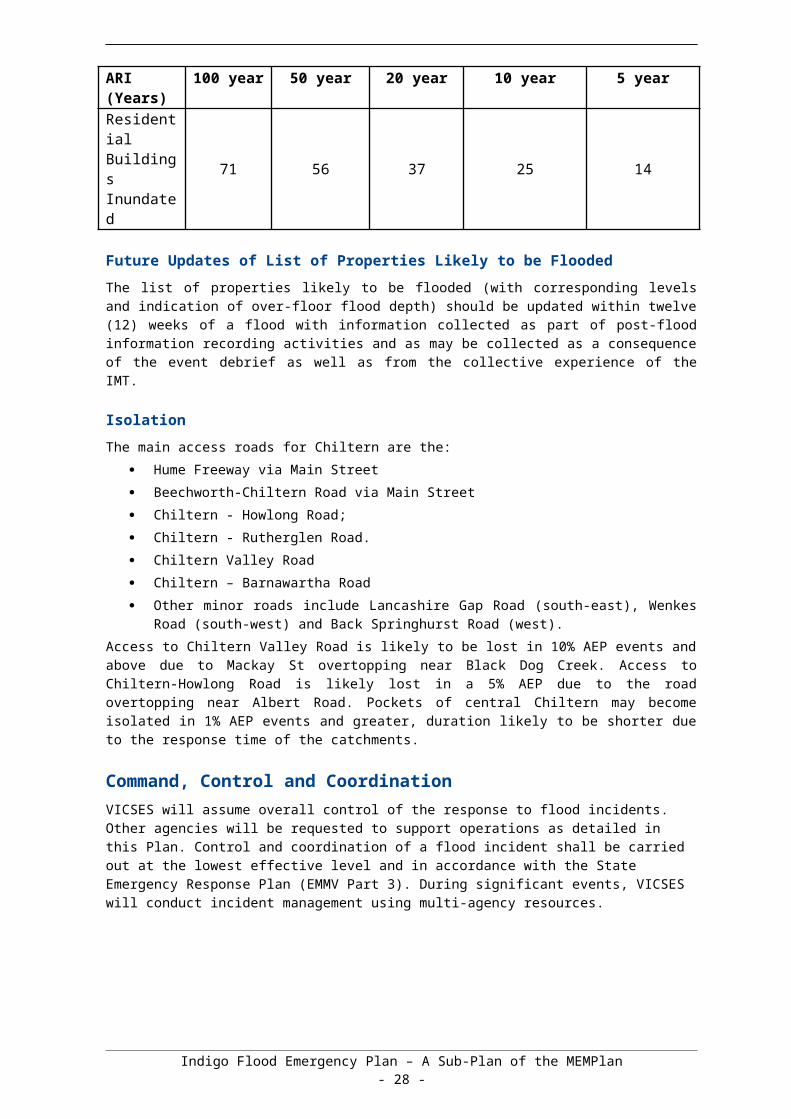
Summary
A summary of the number of properties likely to be flooded at Chiltern are provided below.
A detailed list of inundated properties was not available from the flood study. The properties inundated were estimated based on a visual inspection of aerial imagery and property parcels within the flood extent.
Accurate determination of properties flooded above or below floor, is not available.
AEP (%) 1 % 2 % 5 % 10 % 20 %ARI (Years) 100 year 50 year 20 year 10 year 5 yearResidential Buildings Inundated
71 56 37 25 14
Indigo Flood Emergency Plan – A Sub-Plan of the MEMPlan- 23 -

Future Updates of List of Properties Likely to be Flooded
The list of properties likely to be flooded (with corresponding levels and indication of over-floor flood depth) should be updated within twelve (12) weeks of a flood with information collected as part of post-flood information recording activities and as may be collected as a consequence of the event debrief as well as from the collective experience of the IMT.
Isolation
The main access roads for Chiltern are the:
Hume Freeway via Main Street
Beechworth-Chiltern Road via Main Street
Chiltern - Howlong Road;
Chiltern - Rutherglen Road.
Chiltern Valley Road
Chiltern – Barnawartha Road
Other minor roads include Lancashire Gap Road (south-east), Wenkes Road (south-west) and Back Springhurst Road (west).
Access to Chiltern Valley Road is likely to be lost in 10% AEP events and above due to Mackay St overtopping near Black Dog Creek. Access to Chiltern-Howlong Road is likely lost in a 5% AEP due to the road overtopping near Albert Road. Pockets of central Chiltern may become isolated in 1% AEP events and greater, duration likely to be shorter due to the response time of the catchments.
Command, Control and CoordinationVICSES will assume overall control of the response to flood incidents. Other agencies will be requested to support operations as detailed in this Plan. Control and coordination of a flood incident shall be carried out at the lowest effective level and in accordance with the State Emergency Response Plan (EMMV Part 3). During significant events, VICSES will conduct incident management using multi-agency resources.
APPENDIX C2 – KIEWA River FLOOD EMERGENCY PLAN
Overview of Flooding Consequences
The following is a list of known communities that may be impacted by flooding, dependant on the magnitude of the flood. Other communities may be subject to flash and/or riverine flooding of extreme magnitudes. If a community is not listed below it does not preclude it from flooding.
Tier 1 Communities Tier 2 Communities Tier 3 Communities
Mt Beauty Kiewa
Tawonga South Kergunyah
Yackandandah (Yack Creek) Tangambalanga
Indigo Flood Emergency Plan – A Sub-Plan of the MEMPlan- 24 -

Tier 1 – High flood risk communities with larger populations and flood study informationTier 2 – High flood risk communities, smaller populations, may or may not have flood study informationTier 3 – Lesser flood risk communities, smallest populations, may or may not have flood study information
Major Water Storages
A number of significant water storages are located in the catchment and those that are considered major water storages are detailed in the table below.
Water Storage Capacity (ML) Outflow arrangement Operator
Rocky Valley Reservoir
28,400 Hydroelectric AGL Hydro
Junction Dam (Lake Guy)
1,630 Hydroelectric AGL Hydro
Clover Dam 250 Hydroelectric AGL Hydro
Pretty Valley Pondage 350 Hydroelectric AGL Hydro
Mt Beauty Pondage 900 Hydroelectric AGL Hydro
Flood Impacts and Required Actions
Major Road Closures
The following is a list of major roads that may be inundated in a flood dependant on the magnitude of the flood. Note that minor roads may also be inundated in a flood event.
Kiewa Valley Highway – Between Baranduda and Lindsay Road (Yackandandah Creek Bridge), Kergunyah, Kergunyah South
Dederang Road – Between Kiewa Valley Highway and Glen Creek
Kiewa East Rd – Kiewa (C533)
Indigo Flood Emergency Plan – A Sub-Plan of the MEMPlan- 25 -

Flood MitigationMajor Levees
The following describes a number of known major levees in the catchment. This includes numerous minor private levees and structures such as roads, railway lines and irrigation channel banks that may act as levees during floods.
Bay Creek Lane Kergunyah Road LeveeBoyd Road Kiewa East RoadConisbee Lane Kiewa River LeveeCrosthwaite Lane Kiewa Valley HighwayDamms Road Mountain Creek RoadDismantled Railway Murray River Levees at WodongaKergunyah Road Murray Valley HighwayHouse Creek Levee Redbank Mongans RoadKeegans Lane Yackandandah Creek Levee
Rural Flood Risk
Throughout the Kiewa Catchment there are a number of areas that have significant rural flood risk. Though these areas are not highly populated, rural properties are susceptible to isolation and or inundation.
Low lying areas along-
o Kiewa River – Tawonga, Coral Bank, Running Creek, Dederang, Kergunyah, Tangambalanga, Kiewa (Few buildings are at risk)
o Yackandandah Creek – Yackandandah, Osborne’s Flato Murray River
Areas around the tier two communities of –
o Mt. Beauty including the caravan park (Kiewa River)
Areas around the tier three communities of –
o Yackandandah (Yackandandah Creek)o Kiewa (Kiewa River)o Bandiana (Murray River and Kiewa River) (Kiewa Valley Highway Bridge is
susceptible to inundation)
Indigo Flood Emergency Plan – A Sub-Plan of the MEMPlan- 26 -

Kiewa River – Catchment Schematic
Indigo Flood Emergency Plan – A Sub-Plan of the MEMPlan- 27 -
Gauge Location: Kiewa River Gauges
GaugeRiver
Height current
(m)
River height
at historic
Flow ML/D
Flow (m3/s) AHD ARI Consequence / Impacts Reference
Kiewa River at Bandiana
3.3 37,000 10 MAJOR FLOOD LEVEL BOM Dec 20123.32 36,100 Jul-783.42 45,200 May-74
3.5 46,400 20
3.58 61,500September 1998 - Murray Valley Hwy at Killara water over road (liaise with VIC Roads)
3.6 62,600 503.69 75,800 100
35,300 Dec-10
Yackandandah Creek
at Osbornes Flat
3.14 10,300 53.34 12,000 Sep-98
3.4 12,500 Sep-923.46 13,150 May-74
3.5 13,700 103.83 16,800 Nov-053.86 17,100 204.26 21,600 504.47 24,200 1/12/2010 (Note: Kiewa Valley Hwy Bridge damaged in this event)
4.5 25,000 100
Indigo Shire Council Flood Emergency Plan – A Sub-Plan of the MEMPlan- 28 -

Kiewa River at Kiewa
(Main branch)
3.3 MINOR FLOOD LEVEL BOM Dec 2012
3.3Inconvenience. Low-lying areas next to watercourses are inundated which may require the removal of stock and equipment. FIC Kiewa
3.3 Minor roads may be closed and low level bridges submerged. FIC Kiewa3.34 5,350 53.54 6,650 103.62 7,490 Oct-933.63 7,550 Dec-103.66 7,712 20
3.7Evacuation of some houses may be required (properties in proximity to the Kiewa Store). FIC Kiewa
3.7 MODERATE FLOOD LEVEL BOM Dec 20123.7 Main traffic routes may be covered. FIC Kiewa
3.7The area of inundation in rural areas will be substantial requiring the removal of stock. FIC Kiewa
3.71 8,950 503.74 10,400 May-743.75 9,800 1003.76 11,100 Sep-98
3.8 Highest recorded flood level (1998) FIC Kiewa4 MAJOR FLOOD LEVEL BOM Dec 20124 Extensive rural and urban areas inundated. FIC Kiewa
4Properties and towns are likely to be isolated and major traffic routes likely to be closed. FIC Kiewa
4 Evacuation of people from flood-affected areas may be required. FIC Kiewa
Indigo Shire Council Flood Emergency Plan – A Sub-Plan of the MEMPlan- 29 -
Kiewa River at Mongans
Bridge
2.4 MINOR FLOOD LEVEL BOM Dec 20123.5 MODERATE FLOOD LEVEL BOM Dec 2012
3.92 15,900 5Strategic Flood Intel Report
4.5 MAJOR FLOOD LEVEL BOM Dec 2012
4.52 20,300 10Strategic Flood Intel Report
4.66 20,800 December 2010 - Did not impact Mongans Bridge Caravan Park4.96 23,500 Sep-755.24 26,000 20 1/09/2010 - Flooded through Mongans Bridge Caravan Park
5.35 26,200 25Strategic Flood Intel Report
5.66 28,5001/10/1993 - Mt Beauty Holiday Centre 12 sites impacted with Kiewa River flows along the Kiewa Hwy to front entrance of park.
6.59 31,000 50Strategic Flood Intel Report
6.62 36,800 100Flooding effects of the Mt Beauty Holiday centre are caused by the west Kiewa System.
Strategic Flood Intel Report
6.69 36,1001/09/1998 - Mt Beauty Holiday Centre 12 sites impacted. Boyd Road and Kergunyah Road closed water over road.Tawonga Caravan Park 117 Mountain Creek RoadSymmonds Creek overflows at Kiewa Valley Hwy, no gauge information to define threshold.Tawonga Caravan Park - Check levels with Caravan Park Owner and advise to prepare flood plan (refer draft CP Management Plan)
Note: flood intelligence records are approximations. This is because no two floods at a location, even if they peak at the same height, will have identical impacts. Flood intelligence cards detail the relationship between flood magnitude and flood consequences. More details about flood intelligence and its use can be found in the Australian Emergency Management Manuals flood series.
Indigo Shire Council Flood Emergency Plan – A Sub-Plan of the MEMPlan- 30 -

Command, Control and CoordinationVICSES will assume overall control of the response to flood incidents. Other agencies will be requested to support operations as detailed in this Plan. Control and coordination of a flood incident shall be carried out at the lowest effective level and in accordance with the State Emergency Response Plan (EMMV Part 3). During significant events, VICSES will conduct incident management using multi-agency resources.
Indigo Shire Council Flood Emergency Plan – A Sub-Plan of the MEMPlan- 31 -

APPENDIX D - FLOOD EVACUATION ARRANGEMENTSThere are five stages in the evacuation process: decision, warning, withdrawal, shelter and return.
Phase 1 - Decision to EvacuateThe Incident Controller may make the decision to evacuate an at-risk community under the following circumstances:
Properties are likely to become inundated;
Properties are likely to become isolated and occupants are not suitable for isolated conditions;
Public health is at threat as a consequence of flooding and evacuation is considered the most effective risk treatment. This is the role of the Health Commander of the incident to assess and manage. Refer to the State Health Emergency Response Plan (SHERP) for details);
Essential services have been damaged and are not available to a community and evacuation is considered the most effective risk treatment.
The following should be considered when planning for evacuation:
Anticipated flood consequences and their timing and reliability of predictions;
Size and location of the community to be evacuated;
Likely duration of evacuation;
Forecast weather;
Flood Models;
Predicted timing of flood consequences;
Time required to conduct the evacuation;
Time available to conduct the evacuation;
Evacuation priorities and evacuation planning arrangements;
Access and egress routes available and their potential flood liability;
Current and likely future status of essential infrastructure;
Resources required to conduct the evacuation;
Resources available to conduct the evacuation;
Shelter including Emergency Relief Centres, Assembly Areas etc.;
Vulnerable people and facilities;
Transportation;
Registration
People of CALD background and transient populations;
Safety of emergency service personnel;
Different stages of an evacuation process.
The decision to evacuate is to be made in consultation with the MERO, MERC, DHS, Health Commander and other key agencies and expert advice (NECMA and Flood Intelligence specialists) unless time constraints prevent this consultation.
Indigo Shire Flood Emergency Plan – A Sub-Plan of the MEMPlan- 32 -

The following Evacuation Checklist can be used as a guide when evaluating the need for evacuation in a particular area as a result of flooding.
Key Questions Answers
Are there any existing Flood Evacuation Plans within Indigo Shire?
Name of area(s) at risk.
How many people are at risk (including special needs groups)?
When and where are access routes likely to be disrupted?
Is the area a flood island, accessible by road, accessible overland or land locked?
How much time is available to warn the area?Where Flash Flooding risks exist adopt the strategy detailed in Section 3.8 of this MFEP.
Under what circumstances and in what areas is shelter in place and not evacuation the best option?
Where are Flood Relief Centres located?
What are the triggers for evacuation? (i.e. a particular area at a specified gauge height?) – refer to Appendix C of this MFEP.
How will evacuation warning messages be communicated to people? (i.e. OSOM, Emergency Alert, etc.)
Have standard evacuation messages been developed for predicted or likely flood scenarios?
What forms of transport are needed to assist with evacuation?
Where are airbase facilities located?
Where are animal shelter compounds located? Any other arrangements for management and accommodation of pets / animals?
What are the local command and control arrangements for evacuation?
Other Confirmations and Clarifications:
Clarify and confirm local arrangements and responsibilities for evacuation at the local level. This includes: Confirming and facilitating local awareness of responsibilities for the decision to evacuate (i.e. Incident Controller), the
management of evacuation (i.e. VicPol) and the tasks to be undertaken for evacuation (i.e. development and communication of evacuation warnings).
The role of agencies at the local level involved in evacuation (i.e. VicPol, VICSES, Australian Red Cross etc.)Local arrangements must be consistent with arrangements as set out in Section 3.8 of the EMMV and the Evacuation Guidelines.
Indigo Shire Flood Emergency Plan – A Sub-Plan of the MEMPlan- 33 -

Phase 2 – WarningWarnings may include a warning to prepare to evacuate and a warning to evacuate immediately. Once the decision to evacuate has been made, the at-risk community will be warned to evacuate.
Evacuation warnings can be disseminated via methods listed in part 3 of this plan.
Evacuation warning messages will be developed and issued by VICSES in consultation with the MERO, MERC, DHHS and other key agencies and expert advice (CMA’s and Flood Intelligence specialists).
The Incident Controller is responsible for authorising and issuing evacuation messages.
Phase 3 – WithdrawalWithdrawal will be controlled by the Victoria Police Evacuation Manager. The Evacuation Manager is responsible for managing the withdrawal which will include developing an evacuation plan which clearly identifies activities and timelines as well as the roles and responsibilities of any agencies involved.
VICSES will provide advice regarding the most appropriate evacuation routes and locations for at-risk communities to evacuate to, etc.
VICSES, MFB, AV and Local Government will provide resources where available to support VicPol / VicRoads with route control and may assist Victoria Police in arranging evacuation transportation.
VICPOL will control security of evacuated areas.
Evacuees will be encouraged to move using their own transport where possible. Transport for those without vehicles or other means will be arranged – refer to the MEMP.
Special needs groups and vulnerable residents likely to need help may be identified via the Home and Community Care (HACC) database, via Council’s Vulnerable Persons Register or through community network organisations. Refer to MEMP.
Phase 4 – ShelterRelief Centres and / or assembly areas which cater for people’s basic needs may be established to meet the immediate needs of people affected by flooding. Flood Emergency Relief / Recovery Centres and / or Assembly Areas are listed in MEMP.
Indigo Shire is responsible for the provision of emergency shelter and for managing emergency relief centres.
The Incident Controller is responsible for activating emergency relief services.
VicPol in consultation with VICSES will liaise with Local Government and DHS (where regional coordination is required) via the relevant control centre to plan for the opening and operation of relief centres. This can best be achieved through the Emergency Management Team (EMT).
Animal Shelter
Animal management guidelines are provided in the MEMP along with the location and contact details for appropriate animal welfare entities.
Indigo Shire Flood Emergency Plan – A Sub-Plan of the MEMPlan- 34 -

Matters relating to the welfare of livestock, companion animals and wildlife (including feeding and rescue) are to be referred to Department Primary Industries. This includes requests for emergency supply and / or delivery of fodder to stranded livestock or for livestock rescue.
Matters relating to the welfare of wildlife are to be referred to DELWP.
Phase 5 – ReturnReturn will be consistent with the Strategic Plan for the Return of Community
The Incident Controller in consultation with VICPOL will determine when it is safe for evacuees to return to their properties and will arrange for the notification of the community.
VicPol will manage the return of evacuated people with the assistance of other agencies as required.
Considerations for deciding whether to evacuate include:
Current flood situation;
Status of flood mitigation systems;
Size and location of the community;
Access and egress routes available and their status;
Resources required to coordinate the return;
Special needs groups;
Forecast weather;
Transportation particularly for people without access to transport
Disruption to ServicesDisruption to a range of services can occur in the event of a flood. This may include road closures affecting school bus routes, water treatment plant affecting potable water supplies The Indigo Shire MEMPC will undertake additional work to identify these services and update the Plan accordingly.
Service Impact Trigger Point for action
Strategy/Temporary Measures
Essential Community Infrastructure and Property ProtectionEssential Community Infrastructure and properties (e.g. residences, businesses, roads, power supply etc.) that require protection are to be identified during the next version of this plan.:
Facility Impact Trigger Point for action Strategy/Temporary Measures
Indigo Shire Flood Emergency Plan – A Sub-Plan of the MEMPlan- 35 -

RescueResources available within Indigo Shire to assist with rescue operations:
SES Units:
YackandandahChilternBeechworthRutherglen
Additional resources from VICPOL, VICSES, DELWP and CFA may be requested and deployed into the Shire footprint by the Incident Controller
Indigo Shire Flood Emergency Plan – A Sub-Plan of the MEMPlan- 36 -

APPENDIX E - FLOOD WARNING SYSTEMS
Flood Warning Products Flood Warning products and Flood Class Levels can be found on the BoM website. Flood Warning Products include Severe Thunderstorm Warnings, Severe Weather Warnings, Flood Watches and Flood Warnings.
Severe Thunderstorm and Severe Weather WarningsThe BoM can forecast the environment in which severe thunderstorms or small scale weather systems that are locally intense and slow moving may occur and provides a generalised service to that effect. However, it is not yet scientifically possible to predict individual flash flooding events except on time scales of tens of minutes at the very best.
The BoM issues warnings of flash flooding when it becomes apparent that an event has commenced which may lead to flash flooding or when flash flooding has commenced. However, the BoM does not provide warnings for flash flooding for specific creeks and locations.
Flood WatchesFlood watches are issued by the BoM to notify communities and other stakeholders within broad areas (rather than specific catchments) of the potential flood threat from a developing weather situation. They provide a ‘heads up’ of likely flooding.
Flood watches are based on an assessment of the developing weather situation and indicators of current catchment wetness. They provide generalised statements about expected forecast rainfall totals, the current state of the catchments within the target area and the streams at risk from flooding. Instructions for obtaining rain and stream level observations and access to updated Watches and Warnings are also included.
Normally, the BoM would issue a Flood Watch 24 to 36 hours in advance of any likely flooding and issue updates as required. If at any time during that period there was an imminent threat of floods occurring, the Flood Watch would be upgraded to a Flood Warning.
Flood WarningsFlood Warnings are firm predictions of flooding based on actual rainfall and river height information as well as the results of stream flow based models of catchment behaviour that take account of antecedent conditions (i.e. the ‘wetness’ of the catchment, storage levels within dams, etc) and likely future rainfall. Releases from dams are an essential input to such models.
Flood warnings are categorised as ‘minor’, ‘moderate’ or ‘major’ (see BoM website for an explanation of these terms and current flood class levels – see also table below) and indicate the expected severity of the flood for agreed key locations along the river. Flood warnings usually include:
Rainfall amounts for selected locations within and adjacent to the catchment;
River heights and trends (rising, steady, falling) at key locations within the catchment;
Outflows (in ML/d) from major storages within the catchment;
Forecasts of the height and time of flood peaks at key locations;
A weather outlook and the likely impact of expected rainfall on flooding; and A warning re-issue date and time.
Indigo Shire Flood Emergency Plan – A Sub-Plan of the MEMPlan- 37 -
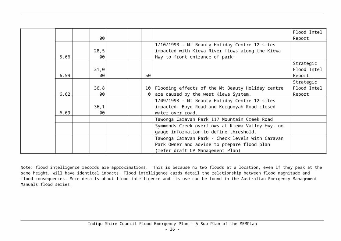
Note 1: The term “local flooding” or “flash flooding” may be used for localised flooding resulting from intense rainfall over a small area.
Note 2: The term “significant rises” may be used in the early stages of an event when it is clear that river levels will rise but it is too early to say whether they will reach flood level.
Additional information (e.g. weather radar and satellite images, updated rain and river level information, details of current watches and warnings) can be obtained from the BoM’s website (www.bom.gov.au/hydro/flood/vic ) and the VICSES website (www.ses.vic.gov.au ).
Flood BulletinsVICSES distributes flood emergency information to the media through “Flood Bulletins”. Flood Bulletins provide BoM Flood Warning information as well as information regarding possible flood consequences and safety advice, not contained in BoM Flood Warning products. VICSES uses the title Flood bulletin to ensure emphasis is placed upon BoM Flood Warning product titles.
The relevant VICSES Region Headquarters or the established ICC will normally be responsible for drafting, authorizing and issuing Flood Bulletins, using the One Source, One Message system.
Flood Bulletins should refer to the warning title within the Bulletin header, for example Flood Bulletin for Major Flood Warning on Yarra River.
Flood Bulletins should follow the following structure
What is the current flood situation;
What is the predicted flood situation;
What are the likely flood consequences;
What should the community do in response to flood warnings;
Where to seek further information;
Who to call if emergency assistance is required.
It is important that the description of the predicted flood situation is consistent with and reflects the relevant BoM Flood Warning.
Flood Bulletins should be focused on specific gauge (or in the absence of gauges, catchment) reference areas, that is the area in which flood consequences specifically relate to the relevant flood gauge.
Flood Bulletins should be prepared and issued after receipt of each Flood Watch and Flood Warning from the BoM, or after Severe Weather or Thunderstorm Warnings indicating potential for severe flash flooding.
To ensure flood bulletins are released in a timely manner, standardised flood bulletins may be drafted based on different scenarios, prior to events occurring. The standardised flood bulletins can then be adapted to the specifics of the event occurring or predicted to occur.
Local Flood Warning System ArrangementsThe need to incorporate local knowledge into planning and community education has been recognised through the Victorian Floods Review which states in Recommendation 22:“State takes the necessary measures to require that local knowledge is considered in flood risk planning, including the verification of flood maps and flood response plans. The need for community involvement in flood planning, flood plain management and emergency response is accepted.”
Indigo Shire Flood Emergency Plan – A Sub-Plan of the MEMPlan- 38 -
The Victorian Emergency Management Reform White Paper further highlights the need to incorporate local knowledge, stating: “Local knowledge on people, history risks, vulnerability, operational requirements, infrastructure and services significantly enhances emergency preparation, response and recovery.”
Local knowledge can be obtained from a variety of sources including VICSES units, CFA Brigades, Police Stations, Water Authorities, CMAs, Local Government and observer networks. Once collected, local knowledge information needs to be processed, validated and assessed. A Local Knowledge Policy is being developed by VICSES to ensure the incorporation of local knowledge in decision making before, during and after incidents. For further detail please refer to www.ses.vic.gov.au
Indigo Shire Flood Emergency Plan – A Sub-Plan of the MEMPlan- 39 -

APPENDIX F – MAPSAll maps listed below are provided in this appendix.
Map 1 – Indigo Shire LGA Map
Map 2 – Chiltern Catchment Map
Map 3 – Chiltern Township Map
Map 4 – Chiltern 1% AEP (100yr ARI) Inundation Map
Map 5 – Chiltern 10% and 20% AEP Inundation Map
Map 6 – Chiltern 2% and 5% AEP Inundation Map
Map 7 – Chiltern 20% AEP (5 year ARI) Flood Study Depth Map
Map 8 – Chiltern 10% AEP (10 year ARI) Flood Study Depth Map
Map 9 Chiltern 5% AEP (20 year ARI) Flood Study Depth Map
Map 10 – Chiltern % AEP (50 year ARI) Flood Study Depth Map
Map 11 – Chiltern 1% AEP (100 year ARI) Flood Study Depth Map
Map 12 – Chiltern PMF Flood Study Inundation Map
Map 13 – Chiltern Flood Study Floodway Overlay/Land Subject to Inundation Map
Map 14 – Chiltern November 2005 Inundation Map
Map 15 – Chiltern Flood Mitigation Works – as constructed 2010-12
Map 16 – Kiewa River Catchment
Indigo Shire Flood Emergency Plan – A Sub-Plan of the MEMPlan- 40 -

Map 1 - Indigo Shire LGA Map
Indigo Shire Flood Emergency Plan – A Sub-Plan of the MEMPlan- 41 -

Map 2 – Chiltern Catchment Map
Indigo Shire Flood Emergency Plan – A Sub-Plan of the MEMPlan- 42 -
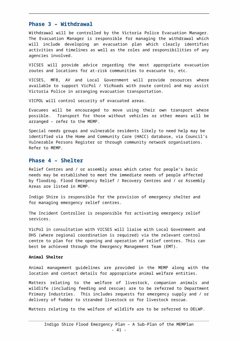
Indigo Shire Flood Emergency Plan – A Sub-Plan of the MEMPlan- 43 -

Map 3 – Chiltern Township Map
Indigo Shire Flood Emergency Plan – A Sub-Plan of the MEMPlan- 44 -

Map 4 – Chiltern 1% AEP (100 year ARI) Inundation Map
Indigo Shire Flood Emergency Plan – A Sub-Plan of the MEMPlan- 45 -

Map 5 – Chiltern 10% and 20% AEP Inundation Map
Indigo Shire Flood Emergency Plan – A Sub-Plan of the MEMPlan- 46 -
Map 6 – Chiltern 2% and 5% AEP Inundation Map
Indigo Shire Flood Emergency Plan – A Sub-Plan of the MEMPlan- 47 -

Map 7 – Chiltern 20% AEP (5 year ARI) Flood Study Depth Map
Indigo Shire Flood Emergency Plan – A Sub-Plan of the MEMPlan- 48 -
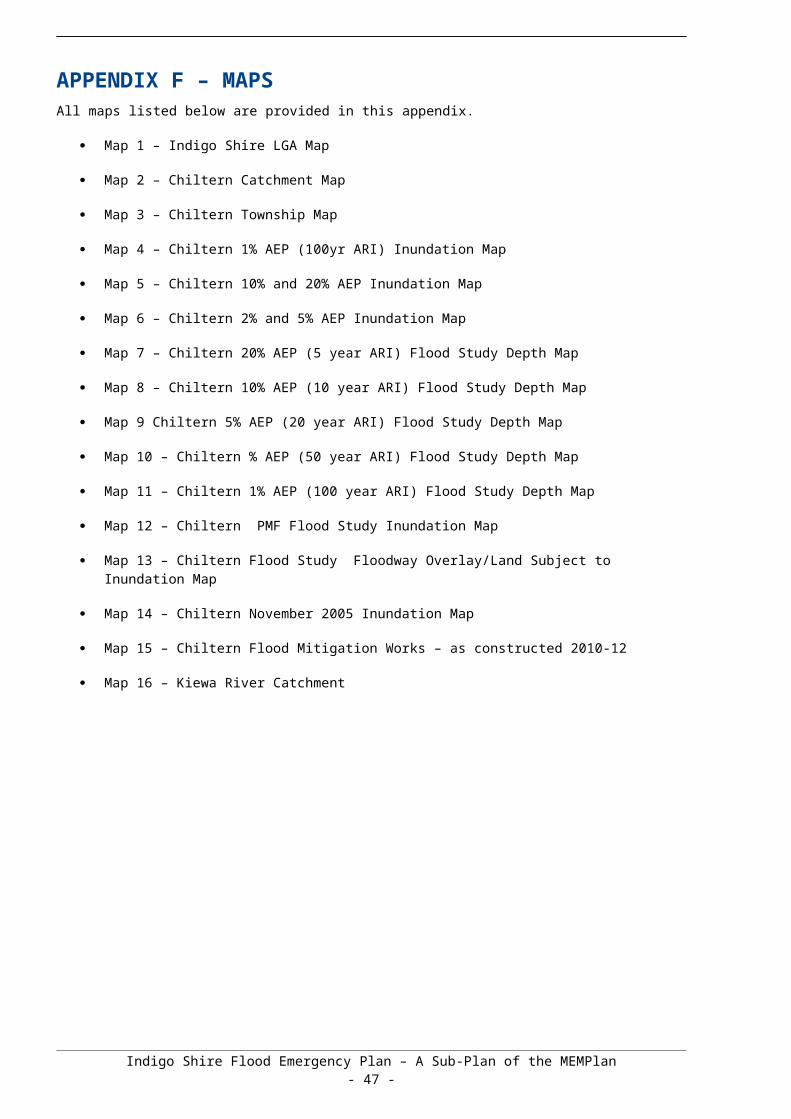
Map 8 – Chiltern 10% AEP (10 year ARI) Flood Study Depth Map
Indigo Shire Flood Emergency Plan – A Sub-Plan of the MEMPlan- 49 -

Map 9 – Chiltern 5% AEP (20 year ARI) Flood Study Depth Map
Indigo Shire Flood Emergency Plan – A Sub-Plan of the MEMPlan- 50 -

Map 10 – Chiltern 2% AEP (50 year ARI) Flood Study Depth Map
Indigo Shire Flood Emergency Plan – A Sub-Plan of the MEMPlan- 51 -

Map 11 – Chiltern 1% AEP (100 year ARI) Flood Study Depth Map
Indigo Shire Flood Emergency Plan – A Sub-Plan of the MEMPlan- 52 -

Map 12 – Chiltern PMF Flood Study Depth Map
Indigo Shire Flood Emergency Plan – A Sub-Plan of the MEMPlan- 53 -

Map 13 – Chiltern Flood Study Floodway Overlay (FO)/Land Subject to Inundation (LSIO) Map
Indigo Shire Flood Emergency Plan – A Sub-Plan of the MEMPlan- 54 -

Map 14 – Chiltern November 2005 Modelled Inundation Map
Indigo Shire Flood Emergency Plan – A Sub-Plan of the MEMPlan- 55 -

Map 15 – Chiltern Flood Mitigation Works – as constructed 2010-12
Indigo Shire Flood Emergency Plan – A Sub-Plan of the MEMPlan- 56 -

Map 16- Kiewa River Catchment
Indigo Shire Flood Emergency Plan – A Sub-Plan of the MEMPlan- 57 -