flood characteristics of upper solo river sub-basin case study
TRANSCRIPT

1
1) Staff of Ministry of Public Works, The Republic of Indonesia. 2) Deputy Director, International Centre for Water Hazard and Risk Management (ICHARM), Japan.
Flood Characteristics of Upper Solo River Sub-basin Case Study : Surakarta City
R. Panji Satrio1) Supervisor : Prof. Shigenobu Tanaka2)
MEE09211
ABSTRACT
Surakarta City is the most important city along Bengawan Solo River. Located on Upper Solo River Sub-basin, Surakarta City in recent years (2007-2009) has frequent flood disaster and inundated. In order to identify the causes of recent frequent floods and to describe the characteristic of flood disaster at Surakarta City, this study is conducted by using basic hydrologic approach, which includes Mann-Kendall test for trend analysis, L-moment method for frequency analysis and flood event analysis to approach the basic hydrologic of the floods event phenomena.
The results of this study show that (1) high precipitation in Upper Solo River Sub-basin, (2) drainage system of the excess of precipitation water in Surakarta City, and (3) insufficiency of Bengawan Solo River mainstream within Surakarta City to flush the excess of peak discharge from the upper stream were the major causes of frequent flood occurrence. Moreover, the flood characteristics at Surakarta City are identified as follow:
1) Point inundation and overflow along the streams run through Surakarta City (Tanggul, Pepe and Anyar) as well as along the drainage-canal system within the City. Such type of flood occurred on April 20, 2007; March 10, 2008 and February 25, 2009.
2) Combination of overflow from the streams run through Surakarta City (Tanggul, Pepe and Anyar) as well as from the drainage-system and overflow from the main stream Bengawan Solo River. This flood characteristic occurred on December 26-31, 2007; January 31, 2009 and February 18, 2009.
Key words : Bengawan Solo River, Surakarta City, Flood Characteristics, L-Moment Method, Mann-
Kendall Trend Analysis
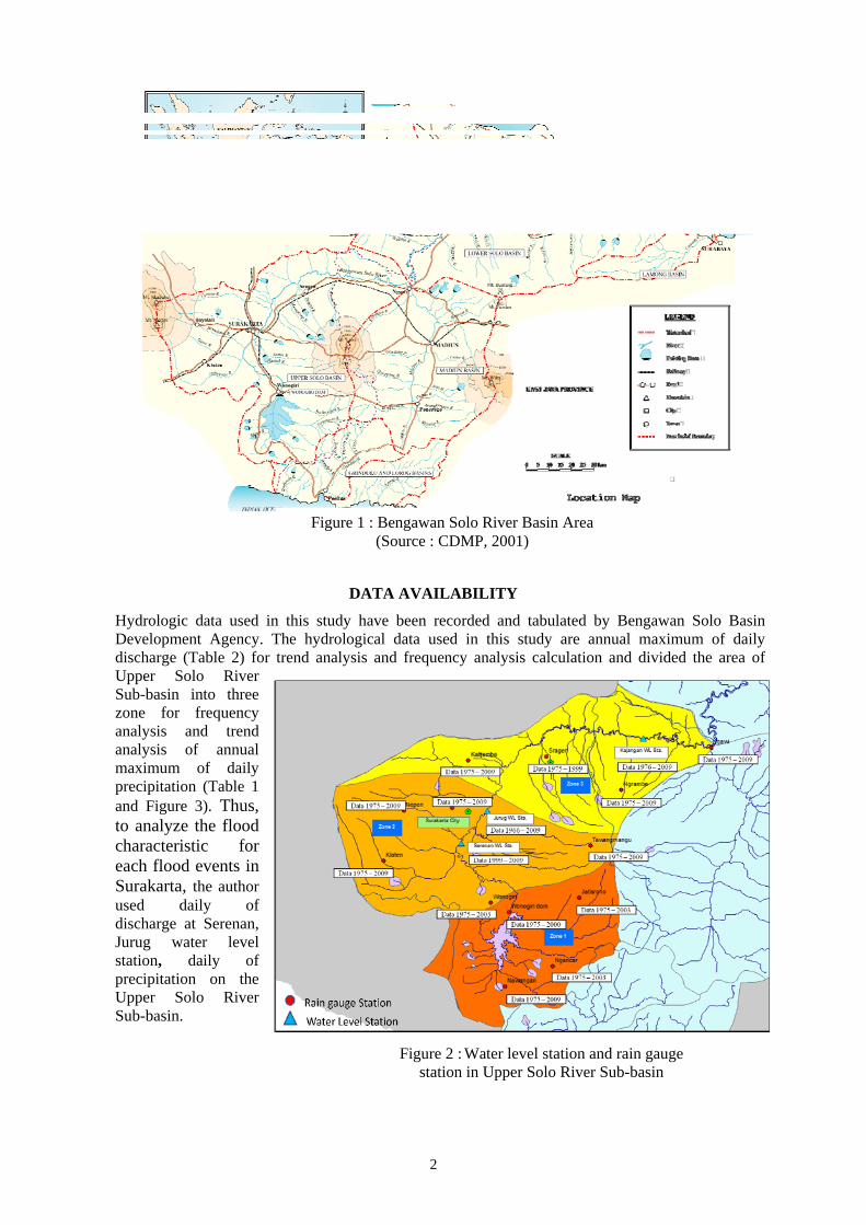
INTRODUCTION The Bengawan Solo River, which lies surrounding Central and East Java Island, The Republic of Indonesia (Figure 1), is an important place for human live since ancient times. Located in Upper Solo River Sub-basin, Surakarta City is an important city on the central Java economic, social development and known as a transit point among those regional areas, such as West Java, East Java, Yogyakarta, and local area in Central Java, which lies passed on Bengawan Solo River.
In March, 1966, the biggest flood recorded within Bengawan Solo river basin area and caused a catastrophic flood disaster in Surakarta City. However, after several river infrastructures countermeasure have been developed, flood disasters are not much decreasing in Upper Solo River sub basin especially in recent years at Surakarta City.
The Flood events at Surakarta that have frequently occurred in recent years (2007-2009) have caused severe economic, social, and ecological damages and losses. Moreover, the target expected in this study to lead the necessity for improvement of flood management and a countermeasure system in Upper Solo River Sub-basin especially in Surakarta City. This study was expected in these outcomes as follows:
1) to determine a root cause of the frequent flood disasters in recent years in Surakarta city, 2) to describe characteristics of flood disaster in Surakarta (2007 to 2009) based on the
hydrological analysis and the phenomenon which occurs in the recent flood events
2
DATA AVAILABILITY
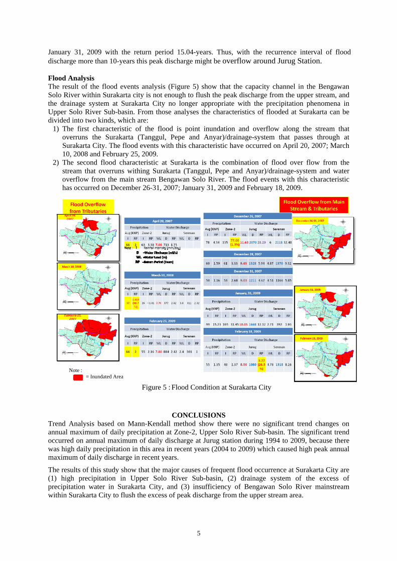
Hydrologic data used in this study have been recorded and tabulated by Bengawan Solo Basin Development Agency. The hydrological data used in this study are annual maximum of daily discharge (Table 2) for trend analysis and frequency analysis calculation and divided the area of Upper Solo River Sub-basin into three zone for frequency analysis and trend analysis of annual maximum of daily precipitation (Table 1 and Figure 3). Thus, to analyze the flood characteristic for each flood events in Surakarta, the author used daily of discharge at Serenan, Jurug water level station, daily of precipitation on the Upper Solo River Sub-basin.
Figure 2 : Water level station and rain gauge station in Upper Solo River Sub-basin
Figure 1 : Bengawan Solo River Basin Area (Source : CDMP, 2001)

3
METHODOLOGY To understand situation and condition of flood characteristics at Surakarta City, the author divided the possible causes of frequent flooding at Surakarta City into three possibilities, which are;
1) A trend of precipitation in the upper Solo River Sub-basin has changed or otherwise in the recent years there has been a significant change in the precipitation phenomenon.
2) A trend of discharge characteristic has changed in the Upper Solo River Sub-basin, which has caused by river development and land development in the Upper Solo River Sub-basin.
3) The capacity of the floodway of Bengawan Solo River along Surakarta City was not enough to flush the excess water from the upper stream area or the capacity of channel/tributaries in and around Surakarta City were not enough to deal with the precipitation phenomena or the characteristic of flood discharge in that area.
To prove those possibilities, the author divides into three hydrologic approach analyses to calculate statistic treatment of hydrologic time series data, as follows as; 1) Mann-Kendall trend analysis of long term hydrologic annual maximum of daily precipitation
and discharge data, to solve and to prove if the trend on the precipitation or the discharge characteristics have changed in recent years;
2) Frequency analysis based on L-Moment method for extreme events was used to see the recurrence interval, probability of the exceedances of the precipitation and the peak flood discharge in the flood events; and
3) Hydrologic analyses, relationship between precipitation and hydrograph shape on the flood events to prove and to determine the flood cause and the characteristic of the flood/inundation at Surakarta City. These possible causes might be from the capacity of the floodway of Bengawan Solo River or from the capacity of channel/tributaries which cross Surakarta city when the precipitation in this area reaches a certain level of intensity.
RESULTS AND DISCUSSION
Trend Analysis
The result of Mann-Kendall test shows that there were no significant upward trends in annual maximum of daily precipitation in Upper Solo River Sub-basin area. High precipitation in recent years (2004-2009) might be the major factors that caused frequent flood occurrence at Surakarta City.
Station Data Analysis (Year) Total Years Data
Wonogiri 1975 – 2003 28 Tawangmangu 1975 – 2009 34 Pabelan 1975 – 2009 34 Nepen 1975 – 2009 34 Klaten 1975 – 2009 34
Station Data Analysis (Years) Total Years Data
Serenan 1999 – 2009 10 urug 1966 – 2009 42 Kajangan 1976 – 2009 33
Figure 3 : Annual Maximum of Daily precipitation on Zone-2
0
1000
2000
3000
4000
1965 1975 1985 1995 2005 2015
Discharge (m
3/s)
Year
Annualy Maximum of Daily Discharge (m3/s)
Serenan Sta. Jurug Sta. Kajangan Sta.
Figure 4 : Annual Maximum of Daily Discharge on Upper Solo River Sub-basin
Table 1: Availability of data precipitation
0
50
100
150
200
250
0
50
100
150
200
250
1965 1975 1985 1995 2005 2015
Precipitation (mm/day)
Year
Precipitation in Zone ‐2
Klaten Nepen Pabelan Z2
Table 2: Availability of data discharge

4
The result of Mann-Kendall analysis of the annual maximum of daily discharge within Upper Solo River Sub-basin (Table 3) shows that there were no significant trends on the annual maximum of daily discharge at Jurug Station during the period 1968 to 2009. The results of observation from 1968 to 1982 before Wonogiri Dam establish and the observation from 1982 until 1994 before river improvement establish in upper stream Bengawan Solo River were same, no significant trend. However, significant upward trend occurred at Jurug station during the short period from 1995 to 2009, but monitoring and observation in this station is still needed for the future because there was high annual maximum of daily precipitation in this area in recent years (2004 to 2009) which caused high peak annual maximum of daily discharge in those years.
Table 3 : Trend Analysis of Annual Maximum of Daily Discharge at Jurug Station
Data Analysis (Years)
Duration Ztest Significant Trends
Sen's Slope
Note
1968 – 2009 All the discharge time series data 1.842 - - There no Data Discharge in 1967
1968 – 1981 Before Wonogiri Dam Construction -0.985 - - There were high precipitation during 2004-2009
1982 – 1994 After Wonogiri Dam Establish to River Improvement construction
0.183 - -
1995 – 2009 After River improvement establish 2.474 Upperward 74.3
Frequency Analysis A statistical flood frequency is based on the assumption of a homogeneous or stationary flood record data. The assumption of the statistic flood frequencies is the data should be on the stationary data condition. Thus, the basin characteristic change or changes on river channel characteristic introduce non-stationarities in the flood records. Based on those assumptions the data analysis for frequency analysis at Jurug and Kajangan station are calculated started from 1995 until 2009 after river improvement in Upper Solo River Sub-basin established in 1987-1994. For Serenan Station the data used for annual maximum of daily discharge data is started in 1999 until 2009 using the available of data record.
The result of frequency analysis using L-moment method for annual maximum of daily precipitation shows that Generalized Logistic Distribution (GLO) is fit for Zone-2, and it is described that many of the precipitation data on the Zone-2 has a high bound tendency for the random time series data. For Regional annual maximum of daily precipitation in Upper Solo River Sub-basin, the L-moment distribution is fitted with the Generalized Extreme Value (GEV).
The result of frequency analysis of annual maximum of daily precipitation during the period of 1975 to 2009 shows that in zone-2, there occurred four times extreme daily precipitation exceeding 10-year recurrent interval (Figure 4). These conditions occurred in 1988 with the probability for return period 33.8-years, in 2004 with the probability for return period 18.1-years, in 2007 with the probability for return period 67.6-years, and the last occurred in 2009 with the probability for return period 18.9-years. The probabilities of annual maximum of daily precipitation show in Zone-2 in recent years (2004 to 2009) occurred many high precipitations, which might be caused flood in Zone-2 area especially at Surakarta City.
The result of frequency analysis of annual maximum of daily discharge in Jurug station (Figure 4) shows that in this station, there occurred two times of extreme annual maximum of daily discharge events equivalent to flood events with a more than 10-year return period. This situation occurred on December 26, 2007 with the return period 30.99-years and
1
10
1001
10
100
0 1000 2000 3000 4000 5000
Exceedan
ce Probab
ility (%)
Return Period (Years)
Discharge (m3/s)
Frequency Analysis of Annual Maximum of Daily Discharge at Jurug Station
GEV
Observation
2
5
20
50
505
80
8
1
10
1001
10
100
0 50 100 150 200
Exceedan
ce Probab
ility (%)
Return Period (Years)
Precipitation (mm)
Frequency Analysis of Annual Maximum of Daily Precipitation in Zone‐2
GLO
Observation
2
5
20
50
505
80
8
Figure 4 : Frequency Analysis of Annual Maximum of Daily
5
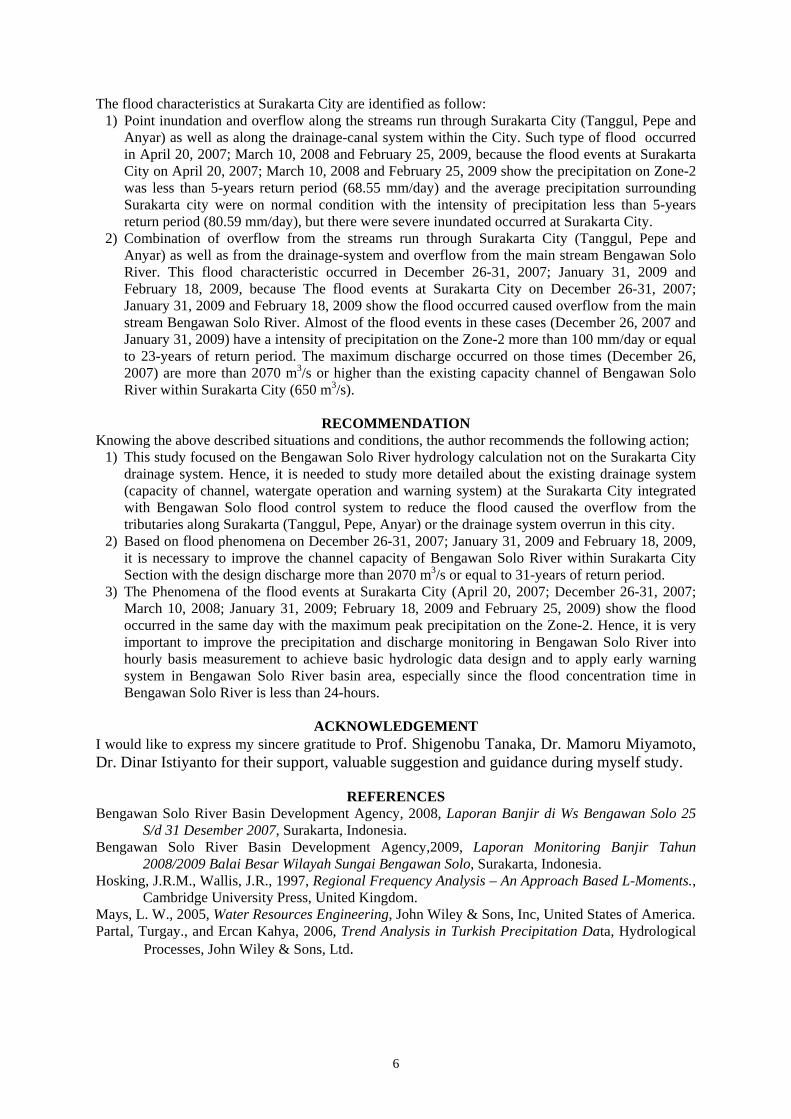
January 31, 2009 with the return period 15.04-years. Thus, with the recurrence interval of flood discharge more than 10-years this peak discharge might be overflow around Jurug Station. Flood Analysis The result of the flood events analysis (Figure 5) show that the capacity channel in the Bengawan Solo River within Surakarta city is not enough to flush the peak discharge from the upper stream, and the drainage system at Surakarta City no longer appropriate with the precipitation phenomena in Upper Solo River Sub-basin. From those analyses the characteristics of flooded at Surakarta can be divided into two kinds, which are:
1) The first characteristic of the flood is point inundation and overflow along the stream that overruns the Surakarta (Tanggul, Pepe and Anyar)/drainage-system that passes through at Surakarta City. The flood events with this characteristic have occurred on April 20, 2007; March 10, 2008 and February 25, 2009.
2) The second flood characteristic at Surakarta is the combination of flood over flow from the stream that overruns withing Surakarta (Tanggul, Pepe and Anyar)/drainage-system and water overflow from the main stream Bengawan Solo River. The flood events with this characteristic has occurred on December 26-31, 2007; January 31, 2009 and February 18, 2009.
CONCLUSIONS Trend Analysis based on Mann-Kendall method show there were no significant trend changes on annual maximum of daily precipitation at Zone-2, Upper Solo River Sub-basin. The significant trend occurred on annual maximum of daily discharge at Jurug station during 1994 to 2009, because there was high daily precipitation in this area in recent years (2004 to 2009) which caused high peak annual maximum of daily discharge in recent years.
The results of this study show that the major causes of frequent flood occurrence at Surakarta City are (1) high precipitation in Upper Solo River Sub-basin, (2) drainage system of the excess of precipitation water in Surakarta City, and (3) insufficiency of Bengawan Solo River mainstream within Surakarta City to flush the excess of peak discharge from the upper stream area.
Figure 5 : Flood Condition at Surakarta City
Note : = Inundated Area
6
The flood characteristics at Surakarta City are identified as follow: 1) Point inundation and overflow along the streams run through Surakarta City (Tanggul, Pepe and
Anyar) as well as along the drainage-canal system within the City. Such type of flood occurred in April 20, 2007; March 10, 2008 and February 25, 2009, because the flood events at Surakarta City on April 20, 2007; March 10, 2008 and February 25, 2009 show the precipitation on Zone-2 was less than 5-years return period (68.55 mm/day) and the average precipitation surrounding Surakarta city were on normal condition with the intensity of precipitation less than 5-years return period (80.59 mm/day), but there were severe inundated occurred at Surakarta City.
2) Combination of overflow from the streams run through Surakarta City (Tanggul, Pepe and Anyar) as well as from the drainage-system and overflow from the main stream Bengawan Solo River. This flood characteristic occurred in December 26-31, 2007; January 31, 2009 and February 18, 2009, because The flood events at Surakarta City on December 26-31, 2007; January 31, 2009 and February 18, 2009 show the flood occurred caused overflow from the main stream Bengawan Solo River. Almost of the flood events in these cases (December 26, 2007 and January 31, 2009) have a intensity of precipitation on the Zone-2 more than 100 mm/day or equal to 23-years of return period. The maximum discharge occurred on those times (December 26, 2007) are more than 2070 m3/s or higher than the existing capacity channel of Bengawan Solo River within Surakarta City (650 m3/s).
RECOMMENDATION
Knowing the above described situations and conditions, the author recommends the following action; 1) This study focused on the Bengawan Solo River hydrology calculation not on the Surakarta City
drainage system. Hence, it is needed to study more detailed about the existing drainage system (capacity of channel, watergate operation and warning system) at the Surakarta City integrated with Bengawan Solo flood control system to reduce the flood caused the overflow from the tributaries along Surakarta (Tanggul, Pepe, Anyar) or the drainage system overrun in this city.
2) Based on flood phenomena on December 26-31, 2007; January 31, 2009 and February 18, 2009, it is necessary to improve the channel capacity of Bengawan Solo River within Surakarta City Section with the design discharge more than 2070 m3/s or equal to 31-years of return period.
3) The Phenomena of the flood events at Surakarta City (April 20, 2007; December 26-31, 2007; March 10, 2008; January 31, 2009; February 18, 2009 and February 25, 2009) show the flood occurred in the same day with the maximum peak precipitation on the Zone-2. Hence, it is very important to improve the precipitation and discharge monitoring in Bengawan Solo River into hourly basis measurement to achieve basic hydrologic data design and to apply early warning system in Bengawan Solo River basin area, especially since the flood concentration time in Bengawan Solo River is less than 24-hours.
ACKNOWLEDGEMENT I would like to express my sincere gratitude to Prof. Shigenobu Tanaka, Dr. Mamoru Miyamoto, Dr. Dinar Istiyanto for their support, valuable suggestion and guidance during myself study.
REFERENCES
Bengawan Solo River Basin Development Agency, 2008, Laporan Banjir di Ws Bengawan Solo 25 S/d 31 Desember 2007, Surakarta, Indonesia.
Bengawan Solo River Basin Development Agency,2009, Laporan Monitoring Banjir Tahun 2008/2009 Balai Besar Wilayah Sungai Bengawan Solo, Surakarta, Indonesia.
Hosking, J.R.M., Wallis, J.R., 1997, Regional Frequency Analysis – An Approach Based L-Moments., Cambridge University Press, United Kingdom.
Mays, L. W., 2005, Water Resources Engineering, John Wiley & Sons, Inc, United States of America. Partal, Turgay., and Ercan Kahya, 2006, Trend Analysis in Turkish Precipitation Data, Hydrological
Processes, John Wiley & Sons, Ltd.