flight location c-5750 (san luis obispo...
TRANSCRIPT

Page 1
Page 9
Page 6
Page 4
Page 2
Page 10
Page 7
Page 5
Page 3
Page 8
Copyright:© 2013 National Geographic Society, i-cubed
C-5750 (San Luis Obispo County)
0 20 4010 MilesI
Index to Aerial PhotographyPage Key
1
9
6
4
2
10
7
5
3
8
FLIGHT LOCATION
1:675,000Scale of this index:
Counties: San Luis ObispoFlight date(s): 01-01-1939 to 12-31-1939Scale: 1: 20,000Overlap: 60%
Complete Metadata:http://www.library.ucsb.edu/mil/aerial-photography-tools
Note: Not all photographs are held in MIL's collection. Mostpositive transparencies held were made from deterioratingnegatives. MIL has additional frames not shown on index thatcover the same area as photographs that do appear on indexes.Imagery acquired 1986, 2000 and January 2013.
San Luis ObispoCounty

!.
!.
!.
!.
!.
!.
!.
!.
!.
!.
!.!.
!.
!.
!.
!.
!.
!.
!.
!.
!.
!.
!.
!.
!.
!.
!.
!.
!.
!.
!.
!.
!.
!.
!.
!.!.
!.
!.
!.
!.
!.
!.
!.
!.
!.
!.
!.
!.
!.
!.
!.
!.
!.
!.!.
!.
!.
!.
!.
!.
!.
!.
!.
!.
!.
!.
!.
!.
!.
!.
!.
!.
!.
!.
!.
!.
!.
!.
!.
!.
!.
!.!.
!.
!.
!.
!.
!.
!.
!.
!.
!.
!.!.
!.
!.
!.
!.
!.
!.
!.
!.
!.
!.
!.
!.
!.
!.
!.
!.
!.
!.
!.
!.
!.
!.
!.
!.
!.
!.
!.
!.
!.
!.
!.
!.
!.
!.
!.
!.
!.
!.
!.
!.
!.
!.
!.
!.
!.
!.
!.
!.
!.
!.
!.
!.
!.
!.
!.
!.
!.
235-93
235-94
235-95
235-96
235-97
237-21
237-22
237-23
237-24237-25
237-26
237-27237-28
237-29
237-30
237-31
237-32237-33
237-34
237-43
237-44
237-45
237-46
237-47
237-48
237-49
237-50
237-51
237-52
237-53
237-54
237-55
237-56237-93
237-94
237-95
237-96
237-97
237-98
237-99
237-100
237-101
237-102
237-103
237-104
237-105
237-106238-4
238-5
238-6
238-7
238-8
238-9
238-10
238-11238-12238-13
238-14
238-15
238-16
238-17238-18238-51
238-52
238-53
238-54
238-55
238-56
238-57
238-58
238-59
238-60
238-61
238-62
238-69
238-70
238-71
238-72
238-73
238-74
245-27245-66
245-67
245-68
245-69
245-102
245-103
245-104
245-105
245-106
245-107
245-108
245-109
Page
1Pa
ge 2
Page 4Page 2
Copyright:© 2013 National Geographic Society, i-cubed
C-5750 (San Luis Obispo County)
0 5 102.5 MilesI
Index to Aerial PhotographyPage 1 of 10
1
9
6
4
2
10
7
5
3
8
FLIGHT LOCATION
1:165,000Scale of this index:
Counties: San Luis ObispoFlight date(s): 01-01-1939 to 12-31-1939Scale: 1: 20,000Overlap: 60%
Complete Metadata:http://www.library.ucsb.edu/mil/aerial-photography-tools
Note: Not all photographs are held in MIL's collection. Mostpositive transparencies held were made from deterioratingnegatives. MIL has additional frames not shown on index thatcover the same area as photographs that do appear on indexes.Imagery acquired 1986, 2000 and January 2013.!.
!.
MIL owns frameMIL does not own frame
San Luis ObispoCounty

!.
!.
!.
!.
!.
!.
!.
!.
!.
!.
!.
!.
!.
!.
!.
!.
!.
!.
!.
!.
!.
!.
!.
!.
!.
!.
!.
!.
!.
!.
!.
!.
!.
!.
!.
!.
!.
!.
!.
!.
!.
!.
!.
!.
!.
!.
!.
!.
!.
!.
!.
!.
!.
!.
!.
!.
!.
!.
!.
!.
!.
!.
!.
!.
!.!.
!.
!.
!.
!.
!.
!.
!.
!.
!.
!.
!.
!.
!.
!.
!.
!.
!.
!.
!.
!.
!.
!.
!.
!.!.
!.
!.
!.
!.
!.
!.
!.
!.
!.
!.
!.
!.
!.
!.
!.
!.
!.
!.
!.
!.
!.
!.
!.
!.
!.
!.
!.
!.
!.
!.
!.
!.
!.
!.
!.
!.
!.
!.
!.
!.
!.
!.
!.
!.
!.
!.
!.
!.
!.
!.
!.
!.
!.
!.
!.
!.
!.
!.
!.
!.
!.
!.
!.
!.
!.
!.
!.
!.
!.
!.
!.
!.
!.
!.
!.
!.
!.
!.
!.
!.
!.
!.
!.
!.
!.
!.
!.
!.
!.
!.
!.
!.
!.
!.
!.
!.
!.
!.
!.
!.
!.
!.
!.
!.
!.
!.
!.
!.
!.
!.
!.
!.
!.
!.
!.
!.
!.
!.
!.
!.
!.
!.
!.
!.
!.
!.
!.
!.
!.
!.
!.
!.
!.
!.
!.
!.
!.
!.
!.
!.
!.
!.
!.
!.
!.
!.
!.
!.
!.
!.
!.
!.
!.
!.
!.
!.
!.
!.
!.
!.
!.
!.
!.
!.
!.
!.
!.
!.
!.
!.
!.
!.
!.
!.
!.
!.
!.
!.
!.
!.
!.
!.
!.
!.
!.
!.
!.
!.
!.
!.
!.
!.
!.
!.
!.
!.
!.
!.
!.
!.
!.
!.
!.
!.
!.
!.
!.
!.
!.
!.
!.
!.
!.
!.
!.
!.
!.
!.
!.
!.
!.
!.
!.
!.
!.
!.
!.
!.
!.
!.
!.
!.
!.
!.
!.
!.
!.
!.
!.
!.
!.
!.
!.
!.
!.
!.
!.
!.
!.
!.
!.
!.
!.
!.
!.
!.
!.
!.
!.
!.
!.
!.
!.
!.
!.
!.
!.
!.
!.
!.
!.
!.
235-1
235-2
235-3
235-4
235-5
235-6
235-7
235-8
235-9
235-10
235-93
235-94
235-95
235-96
235-97
235-98
235-99
235-100
235-101
235-102
235-103
235-104
235-105
235-106
235-107
236-29236-30
236-31
236-32236-33
236-34236-35
236-36
236-37
236-38236-39
236-40
236-41
236-42
236-43236-48
236-49
236-50
236-51
236-52
236-53236-54
236-55
236-56
236-57236-58
236-59
236-60
236-61
236-62236-63236-117237-21
237-22
237-23
237-24237-25
237-26
237-27237-28
237-29
237-30
237-31
237-32237-33
237-34
237-35237-43
237-44
237-45
237-46
237-47
237-48
237-49
237-50
237-51
237-52
237-101
237-102
237-103
237-104
237-105
237-106238-4
238-5
238-6
245-27245-28
245-29
245-30
245-31
245-32
245-33
245-34
245-35
245-36
245-37
245-38
245-39
245-40
245-66
245-67
245-68
245-69
245-70
245-71
245-72
245-73
245-74
245-75
245-76
245-77
245-78
245-79
245-102
245-103
245-104
245-105
245-106
245-107
245-108
245-109
245-110
245-111
245-112245-113
245-114
247-65
247-66
247-67
247-68
247-69
247-70
247-71
247-72
247-73
247-74
247-75
247-76
247-79
247-78
247-77
247-97
247-98
247-99
247-100
247-101
247-102
247-103
247-104
247-105
247-106
247-107
247-108
247-109247-110
247-111
247-112247-113
248-1
248-2
248-3
248-4
248-5
248-6
248-7
248-8
248-9
248-10
248-11
248-12
248-13
248-14
248-15
235-11
235-12
235-13
235-14
251-5
251-6
251-7
251-8
251-9
251-10
251-11
251-12
251-13
251-14251-15
251-16
251-17 251-28
251-29
251-30
251-31
251-32
251-33
251-34
251-35
251-51
251-52
251-53
251-54251-55 251-73265-111
235-15
235-16
235-18
235-19
235-20
235-21
248-16
251-3
246-33
246-34
246-35246-36
246-37246-38
246-39
246-40
246-41246-42
246-43
246-44
246-45246-46
246-47
246-48246-49
246-50
246-51246-52
246-53
246-54246-55
246-56
246-57
246-58
246-59
246-60Pa
ge 1
Page
2
Page 4Page 2
Page
2Pa
ge 3
Page 5Page 3
Copyright:© 2013 National Geographic Society, i-cubed
C-5750 (San Luis Obispo County)
0 5 102.5 MilesI
Index to Aerial PhotographyPage 2 of 10
1
9
6
4
2
10
7
5
3
8
FLIGHT LOCATION
1:165,000Scale of this index:
Counties: San Luis ObispoFlight date(s): 01-01-1939 to 12-31-1939Scale: 1: 20,000Overlap: 60%
Complete Metadata:http://www.library.ucsb.edu/mil/aerial-photography-tools
Note: Not all photographs are held in MIL's collection. Mostpositive transparencies held were made from deterioratingnegatives. MIL has additional frames not shown on index thatcover the same area as photographs that do appear on indexes.Imagery acquired 1986, 2000 and January 2013.!.
!.
MIL owns frameMIL does not own frame
San Luis ObispoCounty

!.
!.
!.
!.
!.
!.
!.
!.
!.
!.
!.
!.
!.
!.
!.
!.
!.
!.
!.
!.
!.
!.
!.
!.
!.
!.
!.
!.
!.
!.
!.
!.
!.
!.
!.
!.
!.
!.
!.
!.
!.
!.
!.
!.
!.
!.
!.
!.
!.
!.
!.
!.
!.
!.
!.
!.
!.
!.
!.
!.
!.
!.
!.
!.
!.
!.
!.
!.
!.
!.
!.
!.
!.
!.
!.
!.
!.
!.
!.
!.
!.
!.
!.
!.
!.
!.
!.
!.
!.
!.
!.
!.
!.
!.
!.
!.
!.
!.
!.
!.
!.
!.
!.
!.
!.
!.
!.
!.
!.
!.
!.
!.
!.
!.
!.
!.
!.
!.
!.
!.
!.
!.
!.
!.
!.
!.
!.
!.
!.
!.
!.
!.
!.
!.
!.
!.
!.
!.
!.
!.
!.
!.
!.
!.
!.
247-75
247-76
247-79
247-78
247-77
247-104
247-105
247-106
247-107
247-108
247-109247-110
247-111
247-112247-113
248-1
248-2
248-3
248-4
248-5
248-6
248-7
248-8
248-9
248-10
248-11
248-12
251-5
251-6
251-7
251-8
251-9
251-10
251-11
251-12
251-13
251-14251-15
251-16
251-17 251-28
251-29
251-30
251-31
251-32
251-33
251-34
251-35
251-36
251-37
251-38
251-39251-44
251-45
251-46
251-47
251-48
251-49
251-50
251-51
251-52
251-53
251-54251-55 251-73
251-74
251-75
251-76
251-77
251-78
251-79
251-80
251-81
251-82
251-83
267-32267-33
267-34
267-35
267-36267-37
267-38
267-39267-40
267-41
267-52267-53
267-54
251-1
251-3246-45246-46
246-47
246-48246-49
246-50
246-51
Page 4Page 2
Page
2Pa
ge 3
Page 5Page 3
Copyright:© 2013 National Geographic Society, i-cubed
C-5750 (San Luis Obispo County)
0 5 102.5 MilesI
Index to Aerial PhotographyPage 3 of 10
1
9
6
4
2
10
7
5
3
8
FLIGHT LOCATION
1:165,000Scale of this index:
Counties: San Luis ObispoFlight date(s): 01-01-1939 to 12-31-1939Scale: 1: 20,000Overlap: 60%
Complete Metadata:http://www.library.ucsb.edu/mil/aerial-photography-tools
Note: Not all photographs are held in MIL's collection. Mostpositive transparencies held were made from deterioratingnegatives. MIL has additional frames not shown on index thatcover the same area as photographs that do appear on indexes.Imagery acquired 1986, 2000 and January 2013.!.
!.
MIL owns frameMIL does not own frame
San Luis ObispoCounty

!.
!.
!.
!.
!.
!.
!.
!.
!.
!.
!.
!.
!.!.
!.
!.
!.
!.
!.
!.
!.
!.
!.
!.
!.
!.
!.
!.
!.
!.
!.
!.
!.
!.
!.
!.
!. !.
!.
!.
!.
!.
!.
!.
!.
!.
!.
!.
!.
!.
!.
!.
!.!.
!.
!.
!.
!.
!.
!.
!.
!.
!.!.
!.
!.
!.
!.
!.
!.
!.
!.
!.
!.
!.
!.
!.
!.
!.
!.
!.
!.
!.
!.
!.
!.
!.
!.
223-29
223-30
223-31
223-32
223-33
223-34
223-35
223-36223-45
223-46
223-47
223-48
223-49
223-50
223-51
223-52224-24
224-25
224-26
224-27
224-28
224-29
224-30
224-31 230-4
230-5
230-6
230-7
230-8
230-9
230-10
230-11 230-74
230-75
230-76
230-77
230-78
230-79
230-80
230-81 230-86
230-87
230-88
230-89
230-90
230-91
230-92
230-93
Page 6Page 4
Page 4Page 2
Page
4Pa
ge 5
Page 7Page 5
Page 5Page 3
Copyright:© 2013 National Geographic Society, i-cubed
C-5750 (San Luis Obispo County)
0 5 102.5 MilesI
Index to Aerial PhotographyPage 4 of 10
1
9
6
4
2
10
7
5
3
8
FLIGHT LOCATION
1:165,000Scale of this index:
Counties: San Luis ObispoFlight date(s): 01-01-1939 to 12-31-1939Scale: 1: 20,000Overlap: 60%
Complete Metadata:http://www.library.ucsb.edu/mil/aerial-photography-tools
Note: Not all photographs are held in MIL's collection. Mostpositive transparencies held were made from deterioratingnegatives. MIL has additional frames not shown on index thatcover the same area as photographs that do appear on indexes.Imagery acquired 1986, 2000 and January 2013.!.
!.
MIL owns frameMIL does not own frame
San Luis ObispoCounty

!. !. !. !.
!.!.!.!.!.!.
!.
!.
!.
!.
!.
!.
!.
!.
!.
!.
!.
!.
!.!.
!.
!.
!.
!.
!.
!.
!.
!.
!.
!.
!.
!.
!.
!.
!.
!.
!.
!.
!.
!.
!.
!.
!. !.
!.
!.
!.
!.
!.
!.
!.
!.
!.
!.
!.
!.
!.
!.
!.!.
!.
!.
!.
!.
!.
!.
!.
!.
!.!.
!.
!.
!.
!.
!.
!.
!.
!.
!.
!.
!.
!.
!.
!.
!.
!.
!.
!.
!.
!.
!.
!.
!.
!.
223-29
223-30
223-31
223-32
223-33
223-34
223-35
223-36223-45
223-46
223-47
223-48
223-49
223-50
223-51
223-52
230-4
230-5
230-6
230-7
230-8
230-9
230-10
230-11 230-74
230-75
230-76
230-77
230-78
230-79
230-80
230-81 230-86230-87
230-88
230-89
230-90
230-91
230-92
230-93230-102
230-103
230-104
230-105
230-106
230-107
230-108
Page 6
Page4
Page 4Page 2
Page
4Pa
ge 5
Page 7Page 5
Page 5Page 3
Copyright:© 2013 National Geographic Society, i-cubed
C-5750 (San Luis Obispo County)
0 5 102.5 MilesI
Index to Aerial PhotographyPage 5 of 10
1
9
6
4
2
10
7
5
3
8
FLIGHT LOCATION
1:165,000Scale of this index:
Counties: San Luis ObispoFlight date(s): 01-01-1939 to 12-31-1939Scale: 1: 20,000Overlap: 60%
Complete Metadata:http://www.library.ucsb.edu/mil/aerial-photography-tools
Note: Not all photographs are held in MIL's collection. Mostpositive transparencies held were made from deterioratingnegatives. MIL has additional frames not shown on index thatcover the same area as photographs that do appear on indexes.Imagery acquired 1986, 2000 and January 2013.!.
!.
MIL owns frameMIL does not own frame
San Luis ObispoCounty

!.
!.
!.
!.
!.
!.
!.
!.
!.
!.
!.
!.
!.
!.
!.
!.
!.
!.
!.
!.
!.
!.
!.
!.
!.
!.
!.
!.
!.
!.
!.
!.
!.
!.
!.
!.
!.
!.
!.
!.
!.
!.
!.
!.
!.
!.
!.
!.
!.
!.
!.
!.
!.
!.
!.
!.
!.
!.
!.
!.
!.
!.!.
!.
!.
!.
!.
!.
!.
!.
!.
!.
!.
!.
!.
!.
!.
!.
!.
!.
!.
!.
!.
!.
!.
!.
!.
!.
!.
!.
!.
!.
!.
!.
!.
!.
!.
!.
!.!.
!.
!.
!.
!.
!. !.
!.
!.
!.
!.
!.
!.
!.
!.
!.
!.
!.
!.
!.
!.
!.
!.
!.
!.
!.
!.
!.
!.
!.
!.
!.
!.
!.
!.
!.
!.
!.
!.
!.
!.
!.
!.
!.
!.
!.
!.
!.
!.
!.
!.
!.
!.
223-12
223-13
223-14
223-15
223-16
223-17
223-18
223-19
223-20
223-21
223-22
223-23
223-24
223-25
223-26
223-27
223-28
223-29223-52
223-53
223-54
223-55
223-56
223-57
223-58
223-59
223-61
223-62
223-63
223-64
223-65
223-66
223-67
223-68
223-69
223-70224-9
224-10
224-11
224-12
224-13
224-14
224-15
224-16
224-17
224-18
224-19
224-20
224-21
224-22
224-23
224-24 230-11
230-15
230-16
230-17
230-18
230-19
230-21
230-22
230-23
230-24
230-25
230-26
230-27
230-28
230-29
230-30
230-31230-54
230-55
230-56
230-57
230-58
230-59
230-60
230-61
230-62
230-63
230-64
230-65
230-66
230-67
230-68
230-69230-72
230-73
230-74 230-93231-2
231-3
231-4
231-5
231-6
231-7
231-8
231-9
231-10
231-11
231-12
231-13
231-14
231-15
231-16
231-17
231-18
223-60
Page 9Page 6
Page 6Page 4
Page
6Pa
ge 7
Page 10
Page7
Page 7Page 5
Copyright:© 2013 National Geographic Society, i-cubed
C-5750 (San Luis Obispo County)
0 5 102.5 MilesI
Index to Aerial PhotographyPage 6 of 10
1
9
6
4
2
10
7
5
3
8
FLIGHT LOCATION
1:165,000Scale of this index:
Counties: San Luis ObispoFlight date(s): 01-01-1939 to 12-31-1939Scale: 1: 20,000Overlap: 60%
Complete Metadata:http://www.library.ucsb.edu/mil/aerial-photography-tools
Note: Not all photographs are held in MIL's collection. Mostpositive transparencies held were made from deterioratingnegatives. MIL has additional frames not shown on index thatcover the same area as photographs that do appear on indexes.Imagery acquired 1986, 2000 and January 2013.!.
!.
MIL owns frameMIL does not own frame
San Luis ObispoCounty

!.!.!.!.
!. !. !. !. !.
!.!.!.!.!.!.
!.
!.
!.
!.
!.
!.
!.
!.
!.
!.
!.
!.
!.
!.
!.
!.
!.
!.
!.
!.
!.
!.
!.
!.
!.
!.
!.
!.
!.
!.
!.
!.
!.
!.
!.
!.
!.
!.
!.
!.
!.
!.
!.
!.
!.
!.
!.
!.
!.
!.
!.
!.
!.
!.
!.
!.
!.
!.
!.
!.
!.
!.!.
!.
!.
!.
!.
!.
!.
!.
!.
!.
!.
!.
!.
!.
!.
!.
!.
!.
!.
!.
!.
!.
!.
!.
!.
!.
!.
!.
!.
!.
!.
!.
!.
!.
!.
!.
!.!.
!.
!.
!.
!.
!. !.
!.
!.
!.
!.
!.
!.
!.
!.
!.
!.
!.
!.
!.
!.
!.
!.
!.
!.
!.
!.
!.
!.
!.
!.
!.
!.
!.
!.
!.
!.
!.
!.
!.
!.
!.
!.
!.
!.
!.
!.
!.
!.
!.
!.
!.
!.
!.
!. !.
!. !.
218-19218-20
218-24 218-25218-26
218-95218-96
223-12
223-13
223-14
223-15
223-16
223-17
223-18
223-19
223-20
223-21
223-22
223-23
223-24
223-25
223-26
223-27
223-28
223-29223-52
223-53
223-54
223-55
223-56
223-57
223-58
223-59
223-61
223-62
223-63
223-64
223-65
223-66
223-67
223-68
223-69
223-70
230-11
230-15
230-16
230-17
230-18
230-19
230-21
230-22
230-23
230-24
230-25
230-26
230-27
230-28
230-29
230-30
230-31230-54
230-55
230-56
230-57
230-58
230-59
230-60
230-61
230-62
230-63
230-64
230-65
230-66
230-67
230-68
230-69230-72
230-73
230-74 230-93
231-2
231-3
231-4
231-5
231-6
231-7
231-8
231-9
231-10
231-11
231-12
231-13
231-14
231-15
231-16
231-17
231-18231-49
231-50
231-51
231-52
231-53
231-54
231-55
231-56
231-57
231-58
231-59
231-60
231-61
231-62
231-63
231-64
231-65
230-101
230-102
223-60
Page 9Page 6
Page 6
Page4
Page
6Pa
ge 7
Page 10Page 7
Page 7Page 5
Page
7Pa
ge 8
Copyright:© 2013 National Geographic Society, i-cubed
C-5750 (San Luis Obispo County)
0 5 102.5 MilesI
Index to Aerial PhotographyPage 7 of 10
1
9
6
4
2
10
7
5
3
8
FLIGHT LOCATION
1:165,000Scale of this index:
Counties: San Luis ObispoFlight date(s): 01-01-1939 to 12-31-1939Scale: 1: 20,000Overlap: 60%
Complete Metadata:http://www.library.ucsb.edu/mil/aerial-photography-tools
Note: Not all photographs are held in MIL's collection. Mostpositive transparencies held were made from deterioratingnegatives. MIL has additional frames not shown on index thatcover the same area as photographs that do appear on indexes.Imagery acquired 1986, 2000 and January 2013.!.
!.
MIL owns frameMIL does not own frame
San Luis ObispoCounty

!. !. !. !. !. !. !. !. !. !. !. !. !. !. !. !. !. !. !. !. !. !. !.
!.!.!.!.!.!.!.!.!.!.!.!.!.!.!.!.!.!.!.!.!.!.
!. !. !. !. !.!. !.
!. !. !.!. !. !. !. !. !. !. !. !. !. !.
!.!.!.!.!.!.!.!.!.!.!.!.!.!.!.!.!.!.!.!.!.!.!.!.!.!.!.!.!.!.
!. !. !. !. !. !. !.
!.!. !. !.
!. !. !.!. !. !. !.
!. !. !. !. !. !. !.!. !. !. !. !. !. !.
!.!.!.!.!.!.!.!.!.!.!.
!.!.
!.!.!.!.!.!.!.!.!.!.!.!.!.!.!.!.!.!.
!.!.!.
!.!.
!.!.!.!.
!.!. !. !. !.
!. !. !.
!.!.
216-4 216-5 216-6 216-7 216-8 216-9 216-10 216-11 216-12216-13
216-14 216-15 216-16 216-17 216-18 216-19 216-20 216-21 216-22 216-23216-24
216-33216-34216-35216-36216-37216-38216-39216-40216-41216-42216-43216-44216-45216-46216-47216-48216-49216-50216-51216-52
217-10 217-11 217-12 217-13217-14
217-17 217-18 217-19 217-20 217-21 217-22 217-23 217-27 217-28 217-29 217-30 217-31 217-32217-33
217-40217-41217-42217-43217-44217-45217-46217-47217-48217-49217-50217-51217-52217-53217-54218-6218-7218-8218-9218-10218-13218-14218-15218-16218-17218-18218-19218-20
218-24 218-25 218-26 218-27 218-28 218-29 218-30218-35 218-36 218-37 218-38 218-39 218-40 218-41 218-42
218-43218-44 218-45 218-46 218-47 218-48 218-49 218-50 218-51 218-52 218-53 218-54 218-55 218-56
218-57
218-63218-64218-65
218-66218-67218-68218-69218-70218-71218-72218-73218-74218-75218-76218-79218-80218-81218-82218-83218-84218-85218-86218-87
218-88218-92218-93218-94218-95218-96
259-8259-9259-10
216-3216-2
216-53216-54216-55216-56
217-9217-1 217-2 217-3 217-4217-6 217-7 217-8
218-11218-12
Page 10Page 7
Page 7Page 5
Page
7Pa
ge 8
Copyright:© 2013 National Geographic Society, i-cubed
C-5750 (San Luis Obispo County)
0 5 102.5 MilesI
Index to Aerial PhotographyPage 8 of 10
1
9
6
4
2
10
7
5
3
8
FLIGHT LOCATION
1:165,000Scale of this index:
Counties: San Luis ObispoFlight date(s): 01-01-1939 to 12-31-1939Scale: 1: 20,000Overlap: 60%
Complete Metadata:http://www.library.ucsb.edu/mil/aerial-photography-tools
Note: Not all photographs are held in MIL's collection. Mostpositive transparencies held were made from deterioratingnegatives. MIL has additional frames not shown on index thatcover the same area as photographs that do appear on indexes.Imagery acquired 1986, 2000 and January 2013.!.
!.
MIL owns frameMIL does not own frame
San Luis ObispoCounty

!.
!.
!.
!.
!.
!.
!.
!.
!.
!.
!.
!.
!.
!.!.
!.
!.
!.
!.
!.
!.
!.
!.
!.
!.
!.
!.!.
!.
!.
!.
!.
!.
!.
!.
!.
!.
!.
!.
!.
!.
!.
!.
!.
!.
!.
!.
!.
!.
!.
!.
!.
!.
!.
!.
!.
!.
!.
!.
!.
!.
!.
!.
!.
!.
!.
!.
!.
!.
!.
!.
!.
!.
!.
!.
!.
!.
!.
!.
!.
!.
!.
!.
!.
!.
!.
!.
!.
!.
!.
!.
!.
!.
!.
!.
!.
!.
!.
!.
!.
!.
!.
!.
!.
223-1
223-2
223-3
223-4
223-5
223-6
223-7
223-8
223-9
223-10
223-11223-70
223-71
223-72
223-73
223-74
223-75
223-76
223-77
223-78224-1
224-2
224-3
224-4
224-5
224-6
224-7
224-8
224-9 230-31
230-32
230-33
230-34
230-35
230-36
230-37
230-38
230-39
230-40
230-41
230-42
230-43
230-44
230-45
230-46
230-47
230-48
230-49
230-50
230-51
230-52
230-53
230-54231-18231-19
231-20
231-21
231-22
231-23
231-24
231-25
231-26
231-27
231-28
231-29
231-30
231-31
231-32
Page 9Page 6
Page
9Pa
ge 10
Page 10Page 7
Copyright:© 2013 National Geographic Society, i-cubed
C-5750 (San Luis Obispo County)
0 5 102.5 MilesI
Index to Aerial PhotographyPage 9 of 10
1
9
6
4
2
10
7
5
3
8
FLIGHT LOCATION
1:165,000Scale of this index:
Counties: San Luis ObispoFlight date(s): 01-01-1939 to 12-31-1939Scale: 1: 20,000Overlap: 60%
Complete Metadata:http://www.library.ucsb.edu/mil/aerial-photography-tools
Note: Not all photographs are held in MIL's collection. Mostpositive transparencies held were made from deterioratingnegatives. MIL has additional frames not shown on index thatcover the same area as photographs that do appear on indexes.Imagery acquired 1986, 2000 and January 2013.!.
!.
MIL owns frameMIL does not own frame
San Luis ObispoCounty
!.
!.
!.
!.
!.
!.
!.
!.
!.
!.
!.
!.
!.
!.!.
!.
!.
!.
!.
!.
!.
!.
!.
!.
!.
!.
!.!.
!.
!.
!.
!.
!.
!.
!.
!.
!.
!.
!.
!.
!.
!.
!.
!.
!.
!.
!.
!.
!.
!.
!.
!.
!.
!.
!.
!.
!.
!.
!.
!.
!.
!.
!.
!.
!.
!.
!.
!.
!.
!.
!.
!.
!.
!.
!.
!.
!.
!.
!.
!.
!.
!.
!.
!.
!.
!.
!.
!.
!.
!.
!.
!.
!.
!.
!.
!.
!.
!.
!.
!.
!.
!.
!.
!.
223-1
223-2
223-3
223-4
223-5
223-6
223-7
223-8
223-9
223-10
223-11223-70
223-71
223-72
223-73
223-74
223-75
223-76
223-77
223-78
230-31
230-32
230-33
230-34
230-35
230-36
230-37
230-38
230-39
230-40
230-41
230-42
230-43
230-44
230-45
230-46
230-47
230-48
230-49
230-50
230-51
230-52
230-53
230-54231-18231-19
231-20
231-21
231-22
231-23
231-24
231-25
231-26
231-27
231-28
231-29
231-30
231-31
231-32231-35
231-36
231-37
231-38
231-39
231-40
231-41
231-42
231-43
231-44
231-45
231-46
231-47
231-48
231-49Page9
Page 6Pa
ge 9
Page
10Page 10Page 7
Copyright:© 2013 National Geographic Society, i-cubed
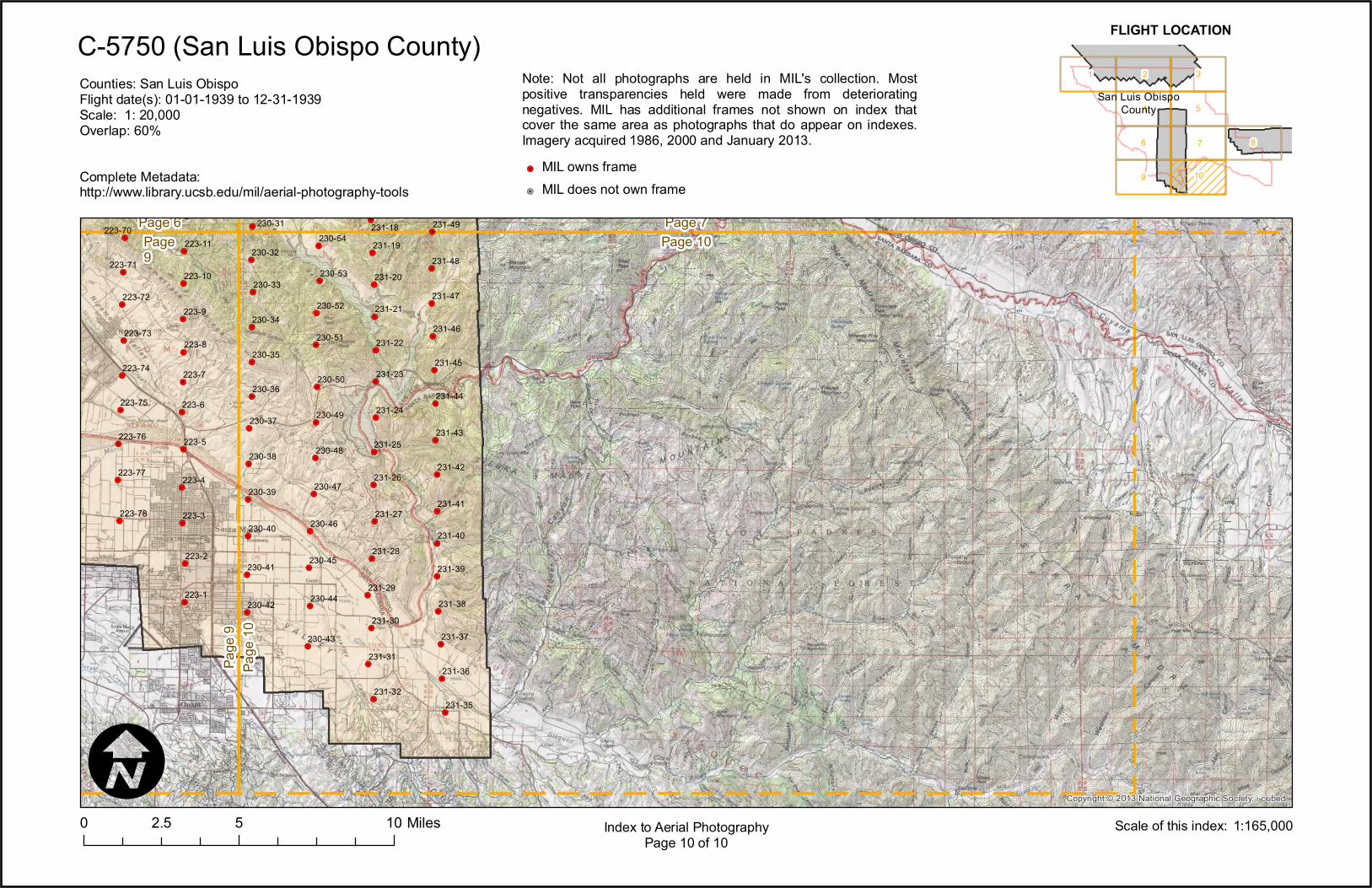
C-5750 (San Luis Obispo County)
0 5 102.5 MilesI
Index to Aerial PhotographyPage 10 of 10
1
9
6
4
2
10
7
5
3
8
FLIGHT LOCATION
1:165,000Scale of this index:
Counties: San Luis ObispoFlight date(s): 01-01-1939 to 12-31-1939Scale: 1: 20,000Overlap: 60%
Complete Metadata:http://www.library.ucsb.edu/mil/aerial-photography-tools
Note: Not all photographs are held in MIL's collection. Mostpositive transparencies held were made from deterioratingnegatives. MIL has additional frames not shown on index thatcover the same area as photographs that do appear on indexes.Imagery acquired 1986, 2000 and January 2013.!.
!.
MIL owns frameMIL does not own frame
San Luis ObispoCounty