five year resource management plan · b. past accomplishments bsf was purchased during 2004/2005...
TRANSCRIPT

TEN-YEAR RESOURCE MANAGEMENT PLAN
FOR THE
BELMORE STATE FOREST
CLAY COUNTY
PREPARED BY
FLORIDA DEPARTMENT OF AGRICULTURE AND CONSUMER SERVICES
DIVISION OF FORESTRY
APPROVED ON
October 10, 2008


BELMORE STATE FOREST
TEN-YEAR RESOURCE MANAGEMENT PLAN
TABLE OF CONTENTS LAND MANAGEMENT PLAN EXECUTIVE SUMMARY............................................................. .1 I. INTRODUCTION............................................................................................................................ .2
A. General Mission, Goals for Florida State Forests, & Management Plan Direction.............. .2 B. Accomplishments, Goals, and Objectives.................................................................................. .2 C. Goals/Objectives for the Next Ten-Year Period....................................................................... .4
II. Administration Section….. ................................................................................................................8 A. Descriptive Information ............................................................................................................ .8
1. Common Name of Property .................................................................................................. .8 2. Location, Boundaries, and Improvements ............................................................................ .8 3. Legal Description and Acreage............................................................................................. .8 4. Degree of Title Interest Held by the Board........................................................................... .8 5. Proximity to Other Public Resources.................................................................................... .8 6. Aquatic Preserve/Area of Critical State Concern ................................................................. .9
B. Acquisition Information............................................................................................................ .9 1. Land Acquisition Program.................................................................................................... .9 2. Legislative or Executive Constraints .................................................................................... .9
3. Purpose for Acquisition ........................................................................................................ .9 4. Designated Single or Multiple Use Management .......................................................9 5. Alternate Uses Considered.........................................................................................10 6. Additional Land Needs ..............................................................................................10 7. Adjacent Conflicting Land Uses................................................................................10 8. Surplus Land Assessment ..........................................................................................10
C. Agency and Public Involvement............................................................................................... 10 1. Responsibilities of Managing Agencies................................................................................ 10 2. Public and Local Government Involvement ......................................................................... 11 3. Compliance with Comprehensive Plan ...........................................................................11
III. Resource Section. ............................................................................................................................. 11 A. Past Uses ..................................................................................................................................... 11 B. Renewable and Non-Renewable Resources............................................................................. 11
1. Soil Types ............................................................................................................................. 11 2. Archaeological and Historical Resources ............................................................................. 11 3. Water Resources ................................................................................................................... 11 4. Fish and Wildlife .................................................................................................................. 12 5. Endangered and Threatened Species………………………………………………………. 12 6. Beaches and Dunes ............................................................................................................... 12 7. Swamps, Marshes, and Other Wetlands................................................................................ 12 8. Mineral Resources ................................................................................................................ 13 9. Unique Natural Features ....................................................................................................... 13 10. Outstanding Native Landscapes ........................................................................................... 13 11. Timber Resource …………………………………………………………………………...13
IV. Management Concepts by Natural Communities and Proposed Management Activities….… 14 A. Existing and Planned Uses ........................................................................................................ 14 1. Property Boundaries Establishment and Preservation ......................................................... 14 2. Soil and Water Protection ..................................................................................................... 14

3. Roads……………………………………………………………………………………..... 14 4. Recreation Management…………………………………………………………………… 15
a. Existing Facilities/Infrastructure/Recreational Activities……………………………... 15 b. Planned Recreational Activities……………………………………………………….. 15
i. Public Access………………………………………………………………..... 15 ii. Parking…………………………………………………………………………15 iii. Recreational Trails……………………………………………………………. 16 iv. Wildlife Viewing...……………………………………………………………. 16 v. Primitive Camping……………………………………………………………. 16
5. Fire Management…………………………………………………………………………... 16 6. Silvicultural Guidelines & Forest Resource Management Objectives…………………….. 17
a. Objectives……………………………………………………………………………… 17 b. Silvicultural Operations………………………………………………………………... 17 c. Timber Inventory Control……………………………………………………………... 18 d. Timber Sales…………………………………………………………………………… 18
7. Research Projects/Specimen Collection………………………………………………….... 19 8. Law Enforcement…………………………………………………………………………...19 9. Recreation Management…………………………………………………………………… 19
a. Timber Management………………………………………………………………….. 19 b. Prescribed Burning…………………………………………………………………….. 20 c. Managing Non-Game Species……………………………………………………….....20 d. Hunter and Public Access…………………………………………………………….. 20 e. Law Enforcement……………………………………………………………………… 20
10. Non-Native Invasive Species ................................................................................................ 20 11. Insects and Disease and Forest Health.................................................................................. 21 12. Utility Corridors and Easements ........................................................................................... 21 13. Ground Disturbing Activities................................................................................................ 21 14. On-Site Housing ................................................................................................................... 22 15. Apiaries ................................................................................................................................ 22 16. Cattle Grazing ....................................................................................................................... 22 17. Ground Cover ....................................................................................................................... 22 18. Restoration ............................................................................................................................ 22
a. Fire ................................................................................................................................. 23 b. Hydrology....................................................................................................................... 23 c. Species Composition ...................................................................................................... 23 d. Adaptive Management Monitoring Areas ...................................................................... 23
B. Description of Natural Communities and Proposed Management Activities ....................... 24 1. Mesic Flatwoods…………………………………………………………………………… 24 2. Wet Flatwoods……………………………………………………………………………... 25 3. Baygall……………………… .............................................................................................. 27 4. Sandhill ................................................................................................................................. 27 5. Bottomland Hardwoods…………….. .................................................................................. 29 6. Dome Swamp…………………………………………………………………………... ..... 30 7. Depression Marshes………………. ..................................................................................... 31
C. Impact of Planned Uses on Resources of the Property…………………………………….. 32 1. Timber………………………………………………………………………………………32 2. Wildlife…………………………………………………………………………………….. 32
3. Water……………………………………………………………………………………......32

4. Historical/Archaeological………………………………………………………………….. 32
V. Management Summary……………………………………………………………………............ 32 A. Operations Infrastructure……………………………………………………………………. 32 B. Management Needs Priority Schedule and Cost Estimates…………………………………33 C. Plans for Locating Fragile, Non-renewable Natural and Cultural Resources……………. 35
1. Archaeological Resources………………………………………………………………….. 35 2. Soil and Water Resources………………………………………………………………….. 35 3. Other Resources……………………………………………………………………………. 35
D. Conformation to State Lands Management Plan ................................................................... 36 E. Multiple-Use Potential-Income Producing Activities………………………………………. 36 F. Potential Use of Private Land Managers……………………………………………………..36
VI. References ……………………………………………………………………………………….....36

BELMORE STATE FOREST
TEN-YEAR RESOURCE MANAGEMENT PLAN
EXHIBITS Location Map...............................................................................................................................Exhibit A Satsuma Tract Forest Legacy Resource Management Plan.........................................................Exhibit B Optimal Management Boundary..................................................................................................Exhibit C Management Advisory Group Meeting Summary.......................................................................Exhibit D Compliance with the Local Comprehensive Plan........................................................................Exhibit E Soil Map & Legend......................................................................................................................Exhibit F Management Procedures for Archaeological and Historical Sites and Properties On State Owned or Controlled Lands..........................................................................................Exhibit G Wildlife Species ...........................................................................................................................Exhibit H Endangered or Threatened Species (FNAI Managed Area Tracking Record) ............................Exhibit I Road Map.....................................................................................................................................Exhibit J Planned and Existing Facilities....................................................................................................Exhibit K FNAI Ecological Communities Map ...........................................................................................Exhibit L
TABLES
Table 1-Management Accomplishment Summary ......................................................................Page 3 Table 2- Vegetation Types Found on BSF ..................................................................................Page 24 Table 3- Cost Estimates Organized by Uniform Cost Accounting Council Categories ..............Page 34

LAND MANAGEMENT PLAN EXECUTIVE SUMMARY
LEAD AGENCY: Department of Agriculture and Consumer Services, Division of Forestry
COMMON NAME OF PROPERTY: Belmore State Forest
LOCATION: Clay County
ACREAGE TOTAL: 8,736.71
Historical Natural Communities ACREAGE Historical Natural Communities ACREAGE Mesic Flatwoods 5,783 Depression Marsh 81 Wet Flatwoods 902 Seepage Stream (Aquatic) ** Baygall 774 Blackwater Stream (Aquatic) ** Sandhill 549
** Aquatic areas are not assigned acreage. Bottomland Hardwoods 471 Dome Swamp 176
LEASE/MANAGEMENT AGREEMENT NO.: 4482
Use: Single Multiple X
MANAGEMENT AGENCY RESPONSIBILITY Division of Forestry (Lead Agency) General Forest Resource Management
Florida Fish and Wildlife Conservation Commission Wildlife Resources and Laws
Division of Historical Resources Historical and Archaeological Resource Management
St. John’s River Water Management District Water Resources
DESIGNATED LAND USE: Multiple-Use State Forest TYPE ACQUISITION: Florida Forever ARCHAEOLOGICAL/HISTORICAL SITES: 1 Known
MANAGEMENT NEEDS: Multiple-use Management
ACQUISITION NEEDS/ACREAGE: 38,750.3 Additional Acreage
SURPLUS LANDS/ACREAGE: None
Management Plan Advisory Group meeting/public hearing on 02/20/08 and the Acquisition and Restoration Council public hearing PUBLIC INVOLVEMENT:
DO NOT WRITE BELOW THIS LINE (FOR DIVISION OF STATE LANDS USE ONLY)
ARC Approval Date: BTIITF Approval Date: COMMENTS:
1

2
I. INTRODUCTION
This management plan will address the 8,736.71 acres known as Belmore State Forest (BSF) located in south-central Clay County (Exhibit A), approximately sixteen miles from Green Cove Springs, Florida. This property was acquired under the Florida Forever Program, specifically the Northeast Florida Timberlands and Watershed Reserve Project. Major natural communities found on the forest include sandhill, mesic flatwoods, baygalls, wet flatwoods, and floodplain forest. Belmore is divided laterally by Ates Creek with several smaller tributary creeks including Devil’s Den. The Satsuma Tract of BSF is comprised of approximately 3,496 acres in western Clay County, four miles from Penney Farms and directly north of Camp Blanding Military Reservation. The property was acquired in the fall of 2007, by the St. Johns River Water Management District (SJRWMD), using Forest Legacy Stewardship funds. The property is part of the Northeast Florida Timberlands and Watershed Reserve Project and will be management by the Department of Agriculture and Consumer Services (FDACS), Division of Forestry (DOF) as part of BSF. The Satsuma Tract Forest Legacy Resource Management Plan contains all the necessary information on the tract and was approved by the DOF Director on November 1, 2007 (Exhibit B.) A. General Mission, Goals for Florida State Forests, and Management Plan Direction
The primary mission of the DOF in managing BSF is to protect and manage the unique resources of the forest through a stewardship ethic to assure these resources will be available for future generations. This will be accomplished by implementing sound multiple-use management principles, the main objectives of which will be:
To restore, maintain, and protect in perpetuity, all native ecosystems; To insure long-term viability of populations and species considered rare, endangered,
threatened, or of special concern; To restore, maintain, and protect hydrological functions related to the quality and
quantity of water resources and the health of associated wetland and aquatic natural communities;
To integrate human use through the multiple-use concept, not emphasizing any particular use over the others or over improvement, maintenance, and protection of native ecosystems;
To protect known archaeological and historical resources; and To practice sustainable forest management utilizing sound silvicultural techniques.
This management plan is provided according to requirements of Sections 253.034, 259.032 and 373, Florida Statutes, and was prepared utilizing guidelines outlined in Section 18-2.021 of the Florida Administrative Code. It is not an annual work plan or detailed operational plan but provides general guidance for the management of BSF for the next ten-years and outlines the major concepts that will guide the management activities on the forest.
B. Past Accomplishments
BSF was purchased during 2004/2005 fiscal year. The following is a summary of past accomplishments permitted under the Acquisition and Restoration Council (ARC)/Division of State Lands (DSL) Approved Interim Management Activities.

TABLE 1. Accomplishment Summary for Belmore State Forest FY 2004-2007 Program Activity FY 2004/05 FY 2005/06 FY 2006/07 TOTAL
Tree Planting (Acres/Species) 0 0 0 0 Reforestation/Restoration
Restoration (Acres/Habitat)
0 0 0 0
Wildfire (No./Acres) 0 / 0 2/ 369 0/ 0 2/ 369
Prescribed Burning (Acres/Month) 151 / December 80/ December -- 231 acres 386 / January -- -- 386 acres
Fire
Prescribed Burning
Total No. Acres 537 80 0 617 acres
Boundary Maintenance Miles Marked or Maintained 14.0 0 18.0 32.0 # of Sales 0 0 3 3 Pulpwood Tons 0 0 15,577 15,577 Timber Harvest Chip N Saw Tons 0 0 6,513 6,513 Miles maintained or rebuilt 28.0 16.0 2.0 46.0
Roads/Trails Culverts, low-water crossings installed or replaced 0 5 3 8
Recreation/ Visitor Use # of Visitors 0 0 0 0 Timber Sales 0 0 $280,571.36 280,571.36
Fuelwood 0 0 0 0 Revenue Recreation 0 0 0 0
Information/ Education Number of tours, public broadcasts, news releases, etc.
0 0 1 1
Miscellaneous 90 road signs built and installed 3 gates installed
FNAI listed species survey completed 80 road signs built and installed 1 gate replaced
170 road signs built and installed 4 gates installed

4
C. Goals and Objectives for Next Ten-Year Period The following goals and objectives provide direction and focus management resources for the next 10-year planning period. This section should be used to measure management accomplishments. Funding, agency program priorities, and the wildfire situation during the planning period will determine the degree to which these objectives can be met. The objectives below have been classified as having either short-term (less than two years) or long-term (up to ten years) timelines for completion. The short-term and long-term status of each objective is listed parenthetically following each objective. Management activities that have already been implemented and are anticipated to continue have been classified as “Ongoing, Long-term” for completion.
GOAL 1: Restore, maintain, and protect in perpetuity, all native ecosystems.
OBJECTIVE 1: The long-term objective of prescribed burning is to simulate, as much as possible, a natural fire regime in which the majority of acres are burned during the lightning season. Areas with high fuel loads may require fuel reduction burns during the dormant season before they can safely support lightning season burns. (Ongoing, Long-term)
PERFORMANCE MEASURES: Plan to burn total of 1,000 acres per year during early restoration. Burn acreages will increase annually during this 10-year planning period as trees mature and overstocked pines are thinned. Update the Prescribed Burning Plan annually.
OBJECTIVE 2: Treat upland pine and sensitive wetland communities with timber stand improvement, removal of off-site species, and reforestation with proper species where appropriate. (Ongoing, Long-term)
PERFORMANCE MEASURES: Percent of total acres treated.
OBJECTIVE 3: Protect environmentally sensitive communities and ecotones when preparing firelines and carrying out management activities. (Ongoing, Long-term)
PERFORMANCE MEASURE: Mapped sensitive areas. Number of staff trained in protection of sensitive areas.
OBJECTIVE 4: Reduce high fuel levels in the wet flatwoods on 900 acres, through all available methods. (Ongoing, Long-term)
PERFORMANCE MEASURE: Fuel reduction acreage.
OBJECTIVE 5: Develop a plan that includes an assessment of the need and pilot projects for restoring ground cover where the native ground layer has been eliminated or heavily impacted from historical land use. (Need to include restoration in agricultural areas, home sites, as well as silvicultural areas.) (Short-term)
PERFORMANCE MEASURE: Completion of the plan and the number of pilot projects implemented.
OBJECTIVE 6: Locate, identify, and control exotic plants. (Ongoing, Long-term)

5
PERFORMANCE MEASURE: Number of acres identified for treatment. Number of acres treated.
OBJECTIVE 7: Construct storage and office space. (Short-term)
PERFORMANCE MEASURE: Completion of construction.
OBJECTIVE 8: Continue annual maintenance on state forest boundaries. (Ongoing, Long-term) PERFORMANCE MEASURE: Percentage of boundary maintained.
OBJECTIVE 9: Assist the Florida Fish and Wildlife Conservation Commission (FWC), in developing a wildlife management plan that addresses all appropriate game and fish species and the sustainability of each based on site-specific population data with a continuing monitoring program. (Short-term)
PERFORMANCE MEASURE: Completion of the wildlife management plan.
GOAL 2: Insuring long-term viability of populations and species considered rare, endangered, threatened, or of special concern.
OBJECTIVE 1: Institute an on-going program of surveying and monitoring for listed species of plants and wildlife. (Ongoing, Long-term)
PERFORMANCE MEASURE: Re-survey scheduled with proposed dates and appropriate organizations identified to perform fieldwork. In addition an updated map showing locations of listed species, their habitat, and breeding areas should be developed.
OBJECTIVE 2: Monitor rare plants to determine population stability or recovery. (Ongoing, Long-term)
PERFORMANCE MEASURE: Number of permanent plots established in critical plant communities.
OBJECTIVE 3: Conduct or contract a comprehensive rare animal species inventory. (Short-term)
PERFORMANCE MEASURE: Completion of the comprehensive inventory.
OBJECTIVE 4: Monitor rare animals to determine population stability or recovery in conjunction with the FWC. (Long-term)
PERFORMANCE MEASURE: Number of surveys for target species. OBJECTIVE 5: Refine map of biological communities with high rare species diversity, such as seepage ravines, seepage slopes, high quality flatwoods and associated ephemeral wetlands, heron rookeries, etc. (Short-term)

6
PERFORMANCE MEASURE: Development of revised map.
OBJECTIVE 6: Conduct a survey for Etonia rosemary. (Short-term)
PERFORMANCE MEASURE: Completion of the survey.
GOAL 3: Restore, maintain, and protect hydrological functions related to the quality and quantity of water resources and the health of associated wetland and aquatic natural communities.
OBJECTIVE 1: Restore natural sheet flow and reduce erosion along trails and roads. (Ongoing, Long-term)
PERFORMANCE MEASURES: Number of culverts replaced or installed at critical trail and road crossings. Low-water crossings installed.
OBJECTIVE 2: Protect water resources during management activities through use of guidelines stated in the Silvicultural Best Management Practices (BMP) Manual. Complete a BMP survey when activities occur to ensure compliance with the most current edition of the manual. (Ongoing, Long-term)
PERFORMANCE MEASURE: Compliance percentage with state lands Silviculture BMP guidelines.
OBJECTIVE 3: Survey and cap abandoned wells on newly acquired land in cooperation with the SJRWMD. (Short-term)
PERFORMANCE MEASURE: Completion of survey and capping.
OBJECTIVE 4: Rehabilitate/restore/re-vegetate closed roads/trails that are badly eroded causing sedimentation flow into the creeks and hydrologic alterations. (Ongoing, Long-term)
PERFORMANCE MEASURE: Number of eroded roads/trails restored compared to the number of roads/trails needing restoration.
GOAL 4: Integrate human use through the multiple-use concept, not emphasizing any particular use over the others or over improvement, maintenance, and protection of native ecosystems.
OBJECTIVE 1: Implement a 5-Year Outdoor Recreation Plan and update on an annual basis. (Short-term)
PERFORMANCE MEASURE: 5-Year Outdoor Recreation Plan implemented and updated annually.
OBJECTIVE 2: Implement a 10-Year Road Management Plan and update on an annual basis. (Short-term)

7
PERFORMANCE MEASURE: 10-Year Road Management Plan implemented and updated annually.
OBJECTIVE 3: Increase visibility by all cooperating law enforcement agencies to reduce illegal hunting, fishing, off-road use, and litter violations. (Ongoing, Long-term)
PERFORMANCE MEASURE: An increase or decrease in the number of citations written.
OBJECTIVE 4: Develop an environmental education outreach program with local schools and community groups. (Short-term)
PERFORMANCE MEASURES: Number of programs completed annually. Number of
groups involved.
GOAL 5: Protect known archaeological and historical resources.
OBJECTIVE 1: Protect cultural sites when preparing firelines and carrying out other ground disturbing activities. (Ongoing, Long-term)
PERFORMANCE MEASURES: Number of staff trained by Division of Historical Resources (DHR) as archaeological monitors. Site maps updated in the fire management and recreation plans as new archaeological sites are discovered.
GOAL 6: Practice sustainable forest management utilizing sound silvicultural techniques. The forest will be managed to recover from certain forest management practices conducted prior to state purchase such as off-site pine plantations and fire suppression. Timber will be managed on a forest-level scale to produce a multi-aged, naturally regenerating forest with uneven-aged stands; even-aged management may be used where appropriate based on site conditions.
OBJECTIVE 1: Conduct initial stand descriptions and construct a GIS (Geographical Information System) database containing stands, roads, and other data model attributes. Complete annual inventory updates according to Forest Management guidelines. (Short-term)
PERFORMANCE MEASURES: Complete forest stand descriptions and initial inventory within five years of this plan’s implementation. Complete basic GIS database within one year of this plan’s implementation. Number of acres inventoried per year.
OBJECTIVE 2: Implement a 5-Year Timber Management Plan and update on an annual basis. (Short-term)
PERFORMANCE MEASURE: 5-year Timber Management Plan implemented and updated annually.
OBJECTIVE 3: Complete merchantable sand pine plantation removal from forest. (Long-term) PERFORMANCE MEASURE: Number of acres of sand pine plantation removed.
8
II. ADMINISTRATIVE SECTION
A. Descriptive Information
1. Common Name of Property The common name of the property is Belmore State Forest.
2. Location, Boundaries, and Improvements
BSF is located in south-central Clay County, Florida, approximately 16 miles southwest of Green Cove Springs, Florida. The Satsuma Tract of BSF is located 7 miles to the northwest. Forest boundaries are identified on the attached map (Exhibit A).
3. Legal Description and Acreage
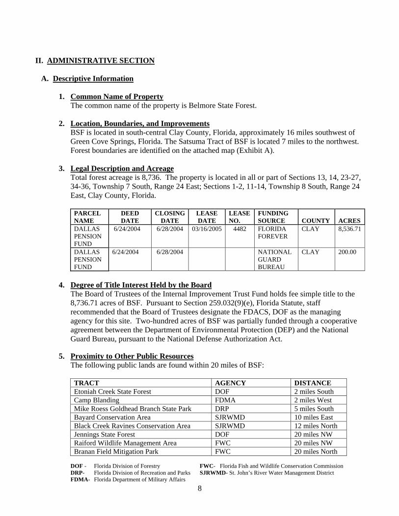
Total forest acreage is 8,736. The property is located in all or part of Sections 13, 14, 23-27, 34-36, Township 7 South, Range 24 East; Sections 1-2, 11-14, Township 8 South, Range 24 East, Clay County, Florida.
PARCEL NAME
DEED DATE
CLOSING DATE
LEASE DATE
LEASE NO.
FUNDING SOURCE COUNTY ACRES
DALLAS PENSION FUND
6/24/2004 6/28/2004 03/16/2005 4482 FLORIDA FOREVER
CLAY 8,536.71
DALLAS PENSION FUND
6/24/2004 6/28/2004 NATIONAL GUARD BUREAU
CLAY 200.00
4. Degree of Title Interest Held by the Board
The Board of Trustees of the Internal Improvement Trust Fund holds fee simple title to the 8,736.71 acres of BSF. Pursuant to Section 259.032(9)(e), Florida Statute, staff recommended that the Board of Trustees designate the FDACS, DOF as the managing agency for this site. Two-hundred acres of BSF was partially funded through a cooperative agreement between the Department of Environmental Protection (DEP) and the National Guard Bureau, pursuant to the National Defense Authorization Act.
5. Proximity to Other Public Resources
The following public lands are found within 20 miles of BSF: TRACT AGENCY DISTANCE Etoniah Creek State Forest DOF 2 miles South Camp Blanding FDMA 2 miles West Mike Roess Goldhead Branch State Park DRP 5 miles South Bayard Conservation Area SJRWMD 10 miles East Black Creek Ravines Conservation Area SJRWMD 12 miles North Jennings State Forest DOF 20 miles NW Raiford Wildlife Management Area FWC 20 miles NW Branan Field Mitigation Park FWC 20 miles North
DOF - Florida Division of Forestry FWC- Florida Fish and Wildlife Conservation Commission DRP- Florida Division of Recreation and Parks SJRWMD- St. John’s River Water Management District FDMA- Florida Department of Military Affairs

9
6. Aquatic Preserve/Area of Critical State Concern The property is not within an aquatic preserve or an area of critical state concern, nor is it in
an area under study for such designation.
B. Acquisition Information 1. Land Acquisition Program
The 8,736.71 acres of Belmore State Forest was purchased with Florida Forever funds under the Northeast Florida Timberlands and Watershed Reserve Project. Two-hundred acres of BSF was partially funded through a cooperative agreement between the DEP and the Florida National Guard, pursuant to the National Defense Authorization Act. Acquisition information for the Satsuma Tract of BSF can be found in the Forest Legacy Resource Management Plan (Exhibit B.)
2. Legislative or Executive Constraints
There are no known legislative or executive constraints specifically directed toward BSF.
3. Purpose for Acquisition The main objectives for the acquisition of the property and the primary goals of the DOF in managing the tract are:
To conserve and protect, through sustainable forestry operations, environmentally unique
and irreplaceable lands that contains native, relatively unaltered flora and fauna representing a natural area unique to, or scarce within, a region of this state or a larger geographical area.
To conserve and protect native species habitat or endangered or threatened species. To conserve, protect, manage, or restore important ecosystems, landscapes, and forests, if
the protection and conservation of such lands is necessary to enhance or protect significant surface water, ground water, coastal, recreational, and timber resources, or to protect fish or wildlife resources which cannot otherwise be accomplished through local and state regulatory programs.
To provide areas, including recreational trails, for natural resource-based recreation. To preserve archaeological or historical sites. To provide support for Camp Blanding’s Forever Initiative which is aimed at preserving
and conserving environmentally sensitive land and animal habitat adjoining the training base while at the same time minimizing incompatible encroachment on military operations within a three-mile buffer along the installation’s boundary.
4. Designated Single or Multiple Use Management
BSF is designated for multiple-use management with the DOF acting as the lead agency as stated in Lease Agreement Number 4482. Authority for multiple-use management is given under Chapters 253 and 589, Florida Statutes. Sound multiple-use management is an overall goal for the property. Multiple-use includes, but is not limited to, the following activities: silviculture management, recreation, wildlife management, archaeological and cultural resource management, ecosystem restoration, environmental education, and watershed management. The goals of the DOF are to protect and manage ecosystems, to restore and

10
maintain biological diversity, and to integrate public use through multiple-use of the forest resources. Multiple-use resource management and the practice of sustainable forestry will provide for the greatest public benefit in perpetuity, while at the same time protecting all the values and resources of the land. Local demands and geographic factors influence the array of uses to be applied to any area of the forest. Only uses compatible with the forest and its ecosystems will be implemented. Forest management practices should ensure that all resources of the forest are sustained for the future. Sustainable forest management will be practiced to ensure long-term forest health.
5. Alternate Uses Considered No alternate uses are being considered at this time. The following uses were considered and determined not compatible: water resource development projects, water supply development projects, storm-water management projects, linear facilities, and communication towers and antennas, except as otherwise outlined in this plan. Other uses will be considered as requests are made and will be accommodated as appropriate if they are determined to be compatible with existing uses and with the management goals and objectives of the forest.
6. Additional Land Needs
There are numerous parcels of land immediately adjacent to the property that should be purchased because they are essential to the management of the property. The DOF will work with these property owners, on a willing seller basis, in an effort to acquire these parcels. Property to acquire adjacent to the forest includes the Reinhold Tract of the Green Creek Drainage to the north and northeast, the Northeast Florida Timberlands to the north containing the South Fork of Black Creek and Ates Creek, and the Wachovia property to the east. Purchasing additional land, within the optimal management boundary (Exhibit C) would facilitate restoration, protection, maintenance, and management of the natural resources on BSF.
7. Additional or Conflicting Land Uses
There are no known conflicting land uses at this time. 8. Surplus Land Assessment
All of the property within the current boundaries of BSF is important for management and none should be declared surplus.
C. Agency and Public Involvement
1. Responsibilities of Managing Agencies
The DOF is responsible for the overall management of the forest. The FWC will assist the DOF in providing technical advice on the management of wildlife populations (game and non-game), setting hunting seasons, establishing bag limits, and enforcing rules and regulations related to the management of the wildlife resources. The DHR cooperates with the DOF regarding appropriate management practices on historical or archaeological sites on the forest as stated in Section 267.061(2) (d), Florida Statutes.
11
2. Public and Local Government Involvement
The FDACS, DOF is responsible for the development of this management plan and its implementation. This plan was submitted to the BSF Management Plan Advisory Group for input and was reviewed at public hearing on February 20, 2008 at Penney Farms Town Hall. A summary of the public hearing and meeting is included (Exhibit D). The ARC public hearing and public meeting serve as an additional forum for public input and review. The DOF also responds to public involvement through communication with individuals, user groups, and government officials.
3. Compliance with Comprehensive Plan This plan was submitted to the Board of County Commissioners in Clay County for review of compliance with their local comprehensive plan (Exhibit E).
III. RESOURCE SECTION
A. Past Uses
Past uses of the tract include timber management, naval stores production, cattle grazing, agriculture, hunting, fishing, and swimming. The land was previously owned by several businesses and families since the early 1900’s. These businesses and families included Emmadine Farms, Foremost Properties Incorporated, O.J. Murrhee, Sylvia Gilman, Gilman Paper Company, Gilman Timberlands Management, and Dallas Police & Fire Pension Fund. Prior to state acquisition most of this land was leased to hunt clubs.
B. Renewable and Non-Renewable Resources
1. Soil Types See Exhibit F for soils information from the USDA, Soil Survey of Clay County, Florida.
2. Archaeological and Historical Resources One historical cemetery plot has been found on BSF and is in the process of being added to the Master Site File. The Bureau of Archaeological Research will conduct an Assessment of Cultural Resources on BSF within the time frame of this plan. The DOF will comply with guidelines outlined in “Management Procedures for Archaeological and Historical Sites and Properties on State Owned or Controlled Lands” (Exhibit G), which will protect known archaeological and historical sites, and will also utilize the expertise of the DHR Conservation and Recreation Lands (CARL) Archaeologists for detecting unknown resources.
3. Water Resources Ates Creek represents the main hydrologic feature on this tract. Ates Creek is a tributary of the South Fork of Black Creek. There are numerous minor tributaries feeding this main creek including Devil’s Den. Ates Creek traverses approximately six miles of BSF. All water bodies on BSF are classified as Class III Surface Waters- Recreation, Propagation, and Maintenance of a Healthy Well-balanced Population of Fish and Wildlife in accordance with Rule 62-302.400 Florida Administrative Code.

12
4. Fish and Wildlife Management of this area will be directed to the production of biological diversity and species composition consistent with existing natural community types. Such communities will be restored and/or maintained through habitat management. All biological resources will be managed to maintain diversity. A list of wildlife species currently observed on BSF is found in Exhibit H.
5. Endangered and Threatened Species In 2006, the Florida Natural Areas Inventory (FNAI) conducted a survey for rare animals, plants, and natural communities on BSF. The FNAI Managed Area Tracking Record (Exhibit I) addresses species of management concern known to be on BSF, or that may reasonably be expected to return to the forest as restoration progresses. FNAI also found the two state-threatened plant species listed below on BSF:
Pinguicula caerulea Blueflower Butterwort Sarracenia minor Hooded Pitcherplant
A DOF Biologist has also confirmed observations of the federally threatened Florida black bear (Ursus americanus floridanus) and gopher tortoise (Gopherus polyphemus) as well as species of special concern such as Sherman’s fox squirrel (Sciurus niger shermani), American alligator (Alligator mississippiensis), and eastern indigo snake (Drymarchon corias couperi) on BSF.
6. Beaches and Dunes There are no beaches or dunes on BSF.
7. Swamps, Marshes, and Other Wetlands BSF contains five known wetland communities, listed in the following table. These communities and the acreages shown below were delineated from 1953 aerial photographs in a project conducted by FNAI to determine the historical distribution of natural communities.
FNAI Communities
Community Acreage Wet Flatwoods 902 Baygall 774 Bottomland Hardwood Forest 471 Dome Swamp 176 Depression Marsh 81 Total Acres 2,404
The water resources on BSF perform essential roles in the protection of water quality, groundwater recharge, flood control and aquatic habitat preservation. In the interest of maintaining these valuable resource functions, state forest management personnel will work with the DOF’s Hydrology Section to incorporate wetland restoration into the overall resource management program as opportunities arise, particularly where wetland systems have been impaired or negatively impacted by previous management activities or natural disasters.

13
Wetland restoration objectives on the state forest include erosion control; restoration of hydrology and/or hydro-period and restoration of wetland plant and animal communities. To achieve these objectives, restoration activities may involve road and soil stabilization, water level control structure removal or installation, exotic species control, site preparation and re-vegetation with native wetland species, and project monitoring. These activities may be conducted individually or concurrently; implemented by DOF personnel or by non-DOF personnel under mitigation or grant contractual agreements. Wetland restoration projects should be conducted in conjunction with other restoration activities indicated elsewhere in this plan. To the extent possible, BSF, with assistance from the DOF’s Hydrology Section, will pursue funding to develop and implement wetland restoration projects. In addition, cooperative research among the DOF, other state agencies, and the federal government will provide valuable information in determining future management objectives of wetland restoration.
8. Mineral Resources
No mineral resources are known to exist on this property.
9. Unique Natural Features Unique natural features found on BSF include seepage streams, blackwater creeks, and slope and bottomland forests.
10. Outstanding Native Landscapes Outstanding native landscapes on BSF include numerous blackwater drainages and creeks that have created a ravine mosaic that provides habitat for the Florida black bear and numerous species of songbirds.
11. Timber Resource The DOF will implement silvicultural practices, including harvesting, burning, and
reforestation, in an attempt to establish a healthy forest with an age distribution that best duplicates natural conditions. Well-timed and executed timber harvests play an integral role in the health of forest ecosystems. Thinning dense forest stands improves understory habitat and allows for more natural regime. Timber harvesting is also used in re-establishing native species by removing off-site trees.
All ongoing timber management practices will follow the recommendations for water quality protection and erosion control contained in the latest version of the Silviculture BMP Manual.
The management of timber resources on BSF will not seek to maximize short-term economic
revenue, but rather to achieve a wide array of long-term public benefits, many of which are intrinsic and not easily quantified. Good stewardship and resource sustainability are essential goals for any proposed silvicultural activity. The health of the forest ecosystem is paramount in importance.
The DOF practices sustainable timber management in the state forest system. This is accomplished by periodically obtaining accurate estimates of standing timber volumes in order to ensure that the timber resource will not be depleted.

14
IV. MANAGEMENT CONCEPTS BY NATURAL COMMUNITIES AND PROPOSED
MANAGEMENT ACTIVITIES
A. Existing and Planned Uses The tract will be managed under the multiple-use concept. As previously stated, Florida Statutes describe the general management philosophy on public land; specifically CARL lands, in order to achieve the greatest combination of benefits to the people of the state. Activities will include restoration, maintenance, and protection of all native ecosystems; integration of appropriate human uses; and insuring long-term viability of populations and species considered endangered, threatened, or of special concern. Integrated activities include: timber management, recreation management, wildlife management, and watershed management. Existing and planned uses are listed.
1. Property Boundary Establishment and Preservation
Seventy-eight percent of the forest boundary has been established, except along wetland boundaries. Boundary line painting and posting was performed by Clay County Fire Control Rangers according to DOF specifications during the 2004-2005 fiscal year.
2. Soil and Water Protection The acquisition and management of public land often has as its objectives, to maximize ecological restoration, protect and manage existing natural resources and facilitate optimum public use. Concern over a continuous usable source of fresh water requires emphasis on protecting this vital resource. Ates Creek bisects the entire length of Belmore State Forest. Numerous seepage streams are found along Ates Creek. The entire watershed within this forest feeds into the South Fork of Black Creek and then eventually into the St. Johns River. There are numerous flatwoods ponds and cypress domes on this forest. These ponds are not conducive to recreation development. Forest management activities relating to timber harvesting practices will comply with the latest version of the Silviculture BMP Manual. Copies of this publication are available upon request from the DOF Forest Hydrology Section.
3. Roads and Bridges Currently, BSF does not have open road access. There is potential for open road public access on the northern and southern sides of the property (Exhibit J). Sharon Road (CR 315) follows the northern boundary of the forest while Bellamy Road follows the southern boundary of the forest. Interior forest roads are composed of sand or clay and have a variety of classifications. An established naming system of the current interior roads is already in place. Plans for the establishment of new roads, if any, will be reviewed by the DOF, DHR, FNAI, and ARC. Currently, there are two concrete bridges and one wooden bridge on the property. These bridges were established by the previous landowners to assist in the access/timber management of the property. The concrete bridge on Reggie Road was examined by DOF personnel and determined to be sound. The concrete bridge on Cripple Creek Road was inspected by Florida Department of Transportation (FDOT) and also determined to be sound, but improvements to the head wall are needed. The wooden bridge on Sand Pine Road was

15
determined to contain severe deficiencies, and has been closed to traffic. This bridge will require replacement in order to facilitate public access and timber operations. One borrow pit is currently present on BSF, and may be utilized as a source of fill dirt for road improvement projects. If borrow pits are needed as a source for fill dirt, applicable permits will be submitted to the SJRWMD prior to excavation. If expansion of the existing perimeter is necessary, the project will be submitted to the DHR and the FNAI for review in keeping with the DOF’s policy on ground disturbing activities.
4. Recreation Management The demand for resource-based outdoor recreation on BSF will continue to grow as the result of urbanized growth from the nearby cities. The primary outdoor recreation objective is to provide the public with dispersed outdoor recreational opportunities that are dependent on the natural environment. These activities may include, but are not limited to, hiking, hunting, fishing, nature study, bicycling, horseback riding, and primitive camping (Exhibit K).
a. Existing Facilities/Infrastructure/Recreational Activities: Currently, no facilities exist on BSF to support management or recreation. The need for, and construction of such facilities will be examined by DOF staff. If a need is determined, requests will be submitted through the proper channels at that time.
There are five potential entrances to BSF. Three (3) of the access points are off Sharon Grade on the north side of the forest and two are located off of Bellamy Road on the south side of the forest.
An old hunt camp site on the western side of the forest could be used as a primitive campsite. Existing roads and firelines could also be used for a trail system.
b. Planned Recreational Activities:
i. Public Access: Forest roads are generally in good shape but may need improvement to facilitate public access. Entrances and some roads will have to be widened to allow two-way traffic. Public ingress/egress should be limited to a few designated sites to limit disturbance and to increase safety.
ii. Parking: Sites for parking areas will have to be determined as the need arises. Areas should be large and stable enough to allow easy maneuvering by large vehicles such as fire control transports and horse trailers. Parking areas will be employed as trailhead access points to areas within the forest. In concentrating and disseminating recreational use from these sites the construction of infrastructure including restrooms, pavilions, and kiosks needs to be evaluated and built when needed.

16
iii. Recreational Trails:
As previously stated, old roads and firelines are available for conversion into recreational trails. Forest managers should focus on scouting possible routes and then implementing a trail system in this planning period.
iv. Wildlife Viewing:
This program offers the non-hunting public greater opportunities for wildlife viewing. The addition of observation towers, ground blinds, and possible food plots may provide excellent wildlife viewing opportunities for the public. When such infrastructure is created, an informational kiosk will be constructed at each location to help the viewer identify wildlife species.
v. Primitive Campgrounds:
As stated above, at least one site is available for the creation of a primitive campground. Other sites should also be examined for suitability as well.
5. Fire Management
The DOF utilizes a total fire management program on state forests that includes wildfire prevention, detection, suppression, and prescribed burning. Primary detection and suppression of wildfires are the responsibility of the DOF under the direction of the Jacksonville District (District-7), particularly the rangers assigned to Penney Farms Work Center. Clay County has five tractor-plow units stationed at Jennings State Forest and Penney Farms Work Center. Emphasis will be placed on prescribed burning, fire prevention, and education to help reduce wildfire occurrence on the forest. The Incident Commander responding to wildfires on BSF has three paramount considerations, listed in order of priority: protection of human lives, protection of both firefighters and public improvements, and protection of natural resources. The annual forest prescribed burning program produces multiple benefits and is considered to be the primary management tool used on the forest. The purpose of prescribed burning on BSF is to restore, maintain, and protect in perpetuity all native ecosystems, ecotones, and their ecological processes. With an average two to four year fire return interval over 7,315 acres of natural communities that require frequent fire; the restoration goal is to burn 1,800 to 3,700 acres annually. During the restoration period of this plan, consideration must be given to the many stands of younger slash pines that are less tolerant of fire, and to the many dense stands of older pines that need to be thinned before they can be effectively burned. These considerations mean that the number of acres burned during the early part of this plan may be lower than expected. As the younger stands become older and more fire tolerant and the dense stands are thinned, prescribed burning acres will increase. Once units have been brought into the fire rotation, they must remain a priority for future prescribed fires. Units that have not had at least one burn will be brought into this rotation whenever possible to accomplish the overall goal of restoring the natural fire regime across the entire forest.
17
Harrowed interior and perimeter firebreaks have been previously established and will be used when feasible on prescribed burns and wildfire control efforts. As fuel loads are reduced, burn units may be combined, reducing the number of interior lines and ultimately improving hydrologic functions and ecosystem processes. Natural firebreaks such as baygall strands and the creeks should be used whenever possible to reduce the disturbance in transition areas. Aerial ignition should be considered as a viable firing technique in hydric areas, especially when these areas are not wet enough to contain a fire. This practice will help achieve the goal of burning across transitions to maintain ecotones and reduce hardwood encroachment. These hydric areas naturally burn periodically; however, due to fire suppression duff layers may be abnormally thick. If these areas are burned when dry, timber losses and smoke problems may outweigh the restoration benefits. To determine the effects of the fire management program, a good monitoring program is needed. This program should include pre and post-burn evaluations. In order to help us achieve these goals a series of fifteen permanent photo plots have been established on the property which are monitored on an annual basis. Some indices of the effectiveness of burns are percent needle scorch, percent fuel consumed, percent stem char, percent overstory mortality, and no net loss of the organic layer. Additionally, fire management facilitates timber management operations and decreases fuel loading, consequently enhancing public safety.
6. Silvicultural Guidelines and Forest Resource Management Operations a. Objectives
The objectives of these silvicultural management guidelines are: 1. To restore health and vigor to the forest ecosystem through prescribed burning and
through reforestation, both naturally and artificially with species native to the site, including longleaf, slash, and loblolly pine.
2. To maintain the forest over the long-term through natural regeneration, uneven-aged,
and where appropriate, even-aged management.
3. To create a naturally regenerating forest with old growth characteristics that yields sustainable economic, ecological, and social benefits.
b. Silvicultural Operations
The forest will be managed to recover from past management practices including intensively managed plantations, intensive site preparation practices, off-site species, and fire exclusion. All stands of off-site slash or sand pine on BSF with merchantable volumes will be scheduled for harvest and subsequent reforestation with the appropriate species.
Prescribed fire and mechanical chopping will be the primary methods of site preparation prior to tree planting. Artificial regeneration, through mechanical or hand planting, will be used to restore old sand pine plantations to productive and diverse longleaf pine sandhill communities.

18
Due to past fire exclusion, the use of herbicides may be needed on BSF. Herbicide applications will be limited to reflect the desired effects on all site species. From past operations, it has been determined that Velpar® ULW rates as low as 1.5 lbs per acre are sufficient to reduce oak populations on sandhills. Chemically treated stands will leave a percentage of residual oak to benefit wildlife.
Thinning, group selection, shelterwood, and clear-cutting will all be necessary for maintenance and restoration of timber stands and communities. On sites, where appropriate, even-aged management will be used on BSF. The DOF’s rotation age range for slash and loblolly pine is sixty to eighty years.
c. Timber Inventory Control
Pre-sale timber inventory and stand descriptions were completed in February 2003 by The Forestry Company. Their survey gives a total merchantable pine forest volume on 2,948 acres of approximately 144,761 tons of pine pulpwood, 71,740 tons of pine chip-n-saw, 15,496 tons of pine saw timber, and 87.5 tons of pine poles. There are approximately 3,327 acres of pre-merchantable pine timber, with an average age of 11, that have not been assigned volumes. Hardwood volumes were also computed in the pre-sale cruise. Total merchantable hardwood forest volume on 1,647 acres is approximately 56,274 tons of hardwood pulpwood, 19,996 tons of hardwood saw timber, 2,323 tons of cypress mulch, and 943 tons of cypress saw timber. Average growth forest wide is predicted to be 6.7 percent per year. In preparation for this plan, stand delineation was completed for BSF. A total of 97 stands have been delineated within the forest boundaries. All stand numbers and acreage information in this plan reflect the new stand delineation. Using inventory guidelines presented in Chapter 6.3 of the State Forest Handbook (DOF 2004), each stand will need to be re-inventoried within the first year after the approval of this plan. Once the initial cruise is completed, portions of the forest will be re-inventoried each year, with each stand re-inventoried at least every ten years.
Within the State Forest System, the annual harvest volume on each forest will not exceed the annual growth for that forest. This is accomplished by obtaining an accurate estimate of the standing timber; it assures that the timber will not be depleted.
d. Timber Sales
Normally, timber sales are advertised for competitive bids and sold as either per unit or lump sum sales. A sealed minimum acceptable bid is set prior to bids being opened. This price is based on the particular class of timber for sale, local stumpage prices, and logging conditions. Salvage sales, where it is necessary to remove damaged timber rapidly, may be sold through a competitive bid process as well, but generally are sold on a per unit basis. With such sales, the mill receiving the wood furnishes weights of the timber, which will be acceptable for payment purposes. All timber sale operations on BSF will be harvested under the supervision of a certified master logger.

19
7. Research Projects/Specimen Collection Research projects may be performed on certain areas of the forest on a temporary or permanent basis for the purpose of obtaining information which furthers the knowledge of forestry and related fields. The DOF cooperates with U.S. Forest Service, the University of Florida and other educational institutions, and governing agencies, in the accumulation of this information. The DOF will consider assisting with research projects when funds and manpower are available. All research projects on BSF must first be approved by the DOF Forest Ecologist in order to be considered. Any requests for research projects should be submitted to the Forest Manager who will forward them to the DOF Forest Ecologist for approval. Requests must include a letter outlining the scope, methodology, and location of the proposed research project. Requests are subject to review by DOF foresters, biologists, Forest Entomologist/Pathologist, and Forest Hydrology Section as appropriate. Permission to conduct research will require that the investigator provide copies to the BSF staff of any reports or studies generated from research projects. The status of existing projects will be reviewed by the state forest staff annually.
8. Law Enforcement
Primary law enforcement responsibilities will be handled by forest staff, FDACS, Office of Agriculture Law Enforcement (OALE), and the FWC wildlife officers. Additional assistance is offered by the Clay County Sheriff’s Office as needed.
9. Wildlife and Fish Management BSF has been designated as a Wildlife Management Area (WMA). The forest will be opened for regulated hunting during the 2008/09 hunting season, which will be managed cooperatively by the FWC. The DOF will provide land management and general supervision following the multiple-use management concept and the FWC will provide technical assistance as a cooperator in managing the wildlife and fish populations, setting hunting seasons, establishing bag and season limits, and overall wildlife and fish law enforcement. Hunters and fishermen will be subject to the same game and fish laws as those on private land, with the exception of any special stipulations for Belmore State Forest.
The FWC has helped to reduce illegal game harvest within Clay County; however, some illegal hunting continues to be a problem. The agencies will coordinate land management plans and procedures in such a manner that the objectives of ecosystem restoration and forest management may be met. In order to enhance wildlife habitat, the following general management guidelines are observed to best meet the needs of both the wildlife and resources of BSF:
a. Timber Management
Timber management will be conducted in a manner specified in above sections to this plan. The DOF recognized the importance of snags for wildlife value. As a general rule, snags will be left alone in their natural environment unless they are deemed to be a potential safety hazard, e.g. boundaries and roads. Areas of significant pine timber mortality will be harvested as directed by the severity of the situation. In areas with tree

20
density basal areas less than 50 ft2, a small portion of this habitat should be left open to promote ground-nesting bird species such as quail.
b. Prescribed Burning
Prescribed burning will be conducted in a manner specified in above sections to this plan. Prescribed burning provides numerous benefits to the forest. Many plant and wildlife species are adapted to frequent fires, and wiregrass in particular is dependent on fire. Burning improves wildlife habitat by promoting the growth of tender new vegetation. This new vegetation is utilized directly by deer, rabbits, and many other small animals, while quail and other birds prefer the seeds produced by recently burned plants. Prescribed burning opens up the forest, helps control competing vegetation, and reduce nuisance insects like ticks that transmit Lyme disease. Prescribed burning also reduces the chance of harmful wildfires by reducing the buildup of fuels.
c. Managing Non-Game Species Non-game species, including rare and sensitive species, will be managed and protected through the maintenance of the native ecosystems found on the property. Research by the other state agencies and institutions and the federal government will provide valuable information in determining the management objectives for non-game wildlife species. Initial species surveys will be conducted by a DOF biologist, other state agency, or a contracted organization depending on funding and other conditions at the time.
d. Hunter and Public Access
The FWC will regulate hunting activities and enforce game laws on BSF. FWC law enforcement efforts may help to reduce illegal hunting activities on BSF. Public access will be limited to designated entrances on the forest.
e. Law Enforcement
FDACS, OALE officers and FWC law enforcement personnel will responsible for handling primary law enforcement on BSF. Additional assistance is offered by the Clay County Sheriff’s Office as needed. FWC will enforce all hunting, and fishing rules governing harvest of game species. FWC law enforcement will continue to patrol the area to enforce the existing laws. Illegal game harvest may be a concern, along with destruction of signage, vandalism, and operation of motor vehicles in closed areas.
10. Non-Native Invasive Species The practice of the DOF is to locate, identify, and eradicate non-native invasive species. An initial survey for non-native invasive species needs to be completed. DOF employees continually monitor the forest for these species while conducting management activities. When non-native invasive species are discovered, an eradication plan will be developed and implemented based upon the severity of the infestation and the availability of personnel and funding. Primarily, known upland non-native invasive species are located along forest roads. Known species include Japanese climbing fern (Lygodium japonicum), sesbania (Sesbania punicea) and cogongrass (Imperata cylindrical). DOF managers will be aware of current availability of different grants and control strategies to lower costs and keep populations in check. State forest management staff will consult with the Forest Health Section to develop scientifically sound response and/or management prescription.

21
11. Insects, Disease, and Forest Health
Currently, the only known insect or disease problem on BSF is the exotic Red Bay Ambrosia beetle. Should unexpected insect/disease outbreaks occur, state forest management staff will consult with the Forest Health Section to develop scientifically sound responses and/or management prescriptions. In compliance with Florida Statute 388.4111, all lands contained within this lease have been evaluated and subsequently designated as environmentally sensitive and biologically highly productive. Such designation is appropriate and consistent with the previously documented natural resources and ecosystem values and affords the appropriate protection for these resources from arthropod control practices that would impose a potential hazard to fish, wildlife, and other natural resources existing on this property. After approval of this plan, the local arthropod control agency will be contacted and will be provided a description of the management objectives for BSF. The local arthropod control agency must then prepare a public lands control plan that is subsequently approved by the DOF, prior to conducting any arthropod control activities for BSF.
12. Utility Corridors
The use of state forest property for utility lines, pipelines, linear facilities, and transportation corridors will be discouraged to the greatest extent possible. The placement of these linear facilities in a forest fragments the natural communities. Requests for linear facility uses will be handled according to the Governor and Cabinet’s linear facility policy which can be found in Chapter 2 of the State Forest Handbook. Currently, there are no established utility corridors on BSF. Florida Power and Light has an established power line utility corridor parallel to the eastern boundary of BSF. BSF does not favor the fragmentation of natural communities with linear facilities; consequently, easements or transfer of ownership for such uses will be discouraged to the greatest extent possible. The DOF does not consider BSF suitable for any new linear facilities.
When such encroachments are unavoidable, previously disturbed sites will be the preferred location. The objectives, when identifying possible locations for new linear facilities will be to cause no damage to sensitive resources (e.g., listed species and archaeological sites), to avoid habitat fragmentation, and to limit disruption of management activities and resource-based multiple-use activities, such as recreation.
The DOF will further encourage the use of underground cable where scenic considerations are desirable. Easements for utilities and other right of ways are subject to the review and approval of the Board of Trustees, and will follow the procedures outlined in Chapter 18-2.010, Florida Administrative Code covering easements.
13. Ground Disturbing Activities Although the DOF’s approach to handling ground disturbing activities is identified in various sections in this plan, the DOF’s overall approach to this issue is summarized here. The DOF recognizes the importance of managing and protecting sensitive resources and will take all
22
necessary steps to ensure that ground disturbing activities will not adversely impact sensitive resources. This includes areas such as archeological and historic sites, ecotones, wetlands, and sensitive species.
The construction of new pre-suppression fire lines will be limited to the greatest extent practicable. When new pre-suppression firelines, recreational trails, or other low-impact recreational site enhancements are necessary, their placement will be carefully monitored by state forest field staff and they will be developed so as to avoid sensitive areas. For other ground disturbing activities such as construction of buildings, parking lots and new roads, DOF will consult with the FNAI, DHR and when necessary, the DSL.
14. On-Site Housing DOF may establish on-site housing (mobile/manufactured home) on BSF if deemed necessary to alleviate security and management issues. The need and feasibility specific for the state forest will be evaluated and established if considered appropriate by the Center/District manager and approved by the DOF Director. On-site housing will only be available to individuals approved by the Director. This type of housing will not exceed three homes per location with the possibility of more than one on-site housing location occurring if considered necessary by the center/district manager and approved by the Director. Prior to the occurrence of any ground disturbing activity for the purpose of establishing on-site housing, a notification will be sent to the DSL as well as packages to the DHR and FNAI for review and recommendations. The package will contain a description of the project (location, number of units, type and amount of ground disturbance, affected natural community type and nearby known archaeological or historical sites), maps (topographic and aerial) and photographs of the area.
15. Apiaries There are currently no apiary leases on Belmore State Forest. The feasibility of pursuing and establishing apiary leases on BSF in areas where appropriate will be evaluated in accordance with the guidelines stated in Chapter 9.1 of the State Forest Handbook
16. Cattle Grazing
Cattle grazing can be a useful tool in fuel reduction planning and will be evaluated where appropriate.
17. Ground Cover
Management activities will be considered and conducted to protect, enhance and restore the condition and integrity of the native ground cover. Management techniques, such as prescribed fire in the growing season, are used to rejuvenate and maintain ground cover to the greatest extent practical.
18. Restoration
The pre-Columbian natural world serves as the standard for the integrity of communities and ecological interactions on BSF. Like many other areas in the Southeastern Coastal Plain, fire and hydrology represent the key ecosystem processes. Thus, the BSF restoration vision focuses on mimicking pre-Columbian fire and hydrological patterns.

23
This restoration philosophy has produced three classes of restoration goals: restoring fire, restoring hydrology, and restoring species composition and structure. These goals often interact and build upon each other. Specific actions to accomplish these goals are spelled out in the management by natural community type section IV-B of this plan.
a. Fire
Prior to settlement, fires in Florida generally burned on a landscape scale until stopped by rain, a body of water, or other natural fire barrier. These fires were frequent and burned most often in the lightning season. The combination of strong wet/dry seasonality and nutrient poor soils produced a pyrogenic flora rich in one-hour and waxy fuels. Management techniques to mirror ancient fire processes include prescribing growing season burns at frequent intervals, burning across transition zones, and restoring fuels that carry fire where the understory has been eliminated.
b. Hydrology
A marked wet and dry season coupled with permeable soils and karst topography results in great extremes of flooding and drought in Florida. The flat land magnifies these conditions. Human habitation has made Florida rich in roads, canals, and retention ponds but poor in historic water flows. Bedded pine plantations cover much of BSF. When stand replacements occur, or when feasible, removal of beds will be evaluated to allow historical sheet-flow across the site.
c. Species Composition
Ensuring that species vital to ecosystem processes are in place on Belmore State Forest is a restoration priority. A continuous, pyrogenic ground cover in systems that should burn is important, as is the presence of longleaf pine. As restoration proceeds, monitoring the response of remnant ground cover will determine ground cover species restoration needs. Juvenile longleaf pine tolerates fire earlier than other woody vegetation allowing a shorter fire return interval to coexist with silviculture. No current plans exist in this ten year period to artificially reintroduce any species probably extirpated from BSF. Some species that may migrate back as restoration proceeds to improve habitat on the forest will be monitored in anticipation of their return, e.g. red-cockaded woodpecker (Picoides borealis).
Restoration also includes the control of invasive exotic species. Aggressive herbicide control will minimize and eventually kill these infestations. Long-term monitoring and control is vital and will be conducted as staffing and funding allow.
d. Adaptive Management Monitoring Area
This ten-year resource management plan represents the best knowledge of the DOF at this time. Since restoration, a key management goal, is inherently experimental, it is important to periodically monitor and re-evaluate land management’s results to ensure they are in line with our mission statement. Re-evaluation practices will both highlight unsatisfactory management practices and practices that have succeeded enough to be de-emphasized or discontinued.

24
B. Description of Natural Communities and Proposed Management Activities In May 2006, the FNAI completed a historic vegetation survey and mapping project for Belmore State Forest (Exhibit L). The purpose of this survey was to delineate the historic natural community types through the use of geo-rectified aerial photographs from 1953 and of ground-truth points. The final results of this survey are summarized below and include a description of the current conditions on BSF, a description of the desired future conditions and a general description of the management actions that are needed to make the current conditions approach the desired conditions. Table 2. Vegetation Types Found on BSF
Vegetation Type Acres Mapped (Historic) (%)
Acres Mapped (Existing)
Silvicultural Production (Y/N)
Burn Interval (Years)
Mesic Flatwoods 5783 (67%) 5786 (67%) Y 2-4 Wet Flatwoods 902 (10%) 902 (10%) Y 2-4 Baygall 774 (9%) 691 (8%) N 50-100 Sandhill 549 (6%) 549 (6%) Y 1-3 Bottomland Hardwoods 471 (5%) 554 (6%) N N/A Dome Swamp 176 (2%) 174 (2%) N 3-100 Depression Marsh 81 (1%) 81 (1%) N 1-8
Mesic Flatwoods Desired Future Condition The desired future condition for mesic flatwoods consists of an open canopy forest of widely spaced, uneven-aged pine forest with a minimal mid-story and an extensive and diverse groundcover. The pine species associated with this community include longleaf pine (Pinus palustris) on higher/drier sites and slash pine (Pinus elliottii) and pond pine (Pinus serotina) in the lower/wetter areas. The subcanopy should be a mix of young pines and a low density of hardwood species such as live oak (Quercus virginiana), sweet bay (Magnolia virginiana), laurel oak (Quercus laurifolia) and persimmon (Diospyros virginiana). The shrub layer should be limited to 50-60% of the understory and may contain species such as saw palmetto (Serenoa repens), gallberry (Ilex glabra), wax myrtle (Myrica cerifera), and shiny blueberries (Vaccinium myrsinites). The groundcover should consist of long-lived perennial grasses such as wiregrass (Aristida stricta), pineywoods dropseed (Sporobolus junceus), lopsided indiangrass (Sorghastrum secundum), and beaksedges (Rhynchospora spp). Other herbaceous vegetation found in this community includes, but is not limited to, gayfeathers (Liatris spp.), coastplain chaffehead (Carphephorus corymbosus), rabbitbells (Crotalaria rotundifolia), orange milkwort (Polygala lutea), and meadowberries (Rhexia spp.).
Current Conditions Most of the mesic flatwoods currently found on BSF have been severely altered through bedded and densely planted slash and loblolly pine plantations. Due to the altered hydrology and dense plantings these stands have suffered from extended period of fire suppression. The sub-canopy consists of loblolly bay (Gordonia lasianthus), swamp bay (Persea palustris), and sweetgum (Liquidambar styraciflua). The groundcover has suffered bedding and ground disturbance causing most of the long-lived perennial grass species mentioned earlier to be absent. There is an extensive shrub layer primarily dominated by saw palmetto, fetterbush (Lyonia lucida), gallberry and wax myrtle. Additionally, there is a strong component of vines present throughout the

25
plantations. These vines include honeysuckle (Lonicera japonica), Virginia creeper (Parthenocissus quinquefolia) and muscadine (Vitis rotundifolia). Restoration Historically, mesic flatwoods would be maintained through reoccurring fires during the growing season with a return frequency between 2-5 years. Unfortunately, due to the prolonged absence of fire on BSF, the high volume of timber resources present, and the high fuel loading it may take at least two dormant season burns prior to conducting any growing season prescribed fire. In several areas, the process of thinning the overstory and a diligent fire regime may be enough to move the flatwoods towards the desired future conditions. In contrast, some areas may require more extensive restoration including but not limited to, mechanical and/or chemical removal of hardwood species, bed removal, and ground cover reseeding in addition to a consistent fire regime. The restoration goal will be to manage the mesic flatwoods with a 2-4 year fire return frequency. Silviculture Silvicultural management will focus on creating an uneven-aged mixture of both slash and longleaf pines. Timber in these areas will be harvested using several methods including row thinning, row thinning with selective harvest in between the take rows, seed tree cuts, shelter wood cuts, and clear-cuts where necessary for stand conversion. Stocking densities and basal areas should be managed to allow adequate sunlight for the promotion of a diverse groundcover (30-80BA). High density merchantable stands and older stands should be thinned first to maintain healthy stands, prevent destructive wildfires, and allow reintroduction of prescribed fire as soon as possible. Timber harvest will be scheduled in order to prevent damage due to saturated soils, limit damage to remnant groundcover, and limit sedimentation in natural drainages. Wet Flatwoods Desired Future Conditions Wet flatwoods are an open, fire maintained pineland on frequently saturated soils. Soils in the wet flatwoods are 0.3 to 1 meter of acidic sands over an organic hardpan or clay layer. The hardpan or clay layer substantially reduces percolation of water and therefore wet flatwoods may remain saturated for over one month during a year. Wet flatwoods are typically found between mesic flatwoods in the uplands and bottomland hardwood, dome swamp or other lowland areas. Wet flatwoods can also serve as transition zone.
The vegetation composition of a wet flatwoods is similar to the composition of vegetation found in the mesic flatwoods but, as the name implies, the wet flatwoods tends to favor more hydrophytic species than do the mesic flatwoods. The desired future condition of wet flatwoods is an open canopy composed of longleaf and slash pines with a few scattered pond pines. The midstory species may include water oak (Quercus niger), laurel oak, red bay (Persea borbonia), swamp bay, persimmon, and dahoon holly (Ilex cassine). Depending on the habitat and the hydrology of a given site, a wet flatwoods understory composition can take on two different forms. In areas with a shorter saturation time there may be a dense shrub layer with a minimal groundcover component or in areas with a longer saturation time period may have a minimal understory of shrubs and a dense groundcover of hydrophytic herbaceous vegetation. Shrub species that occupy wet flatwoods are saw palmetto (Serenoa repens), gallberry (Ilex glabra), myrtle dahoon (Ilex myrtifolia), fetterbush (Lyonia lucida), and titi (Cyrilla racemiflora). Common understory herbaceous species include wiregrass (Aristida stricta),

26
yellow-eyed grasses (Xyris spp.), witchgrasses (Dichanthelium spp.), yellow hatpins (Syngonanthus flavidulus), Virginia chain fern (Woodwardia virginica), beaksedges (Rhynchospora spp.), smallfruit beggarticks (Bidens mitis), aster (Aster spp.), milkworts (Polygala spp.), blue maidencane (Amphicarpum muhlenbergianum), savannah milkweed (Asclepias pedicellata), southern umbrellasedge (Fuirena scirpoidea), greenvein ladiestresses (Spiranthes praecox), few-flower milkweed (Asclepias lanceolata), yellow colicroot (Aletris lutea), small butterwort (Pinguicula pumila), rushes (Juncus spp.), netted chain fern (Woodwardia areolata), Carolina redroot (Lachnanthes caroliniana), hooded pitcher plant (Sarracenia minor), toothache grass (Ctenium aromaticum), tuberous grasspink (Calopogon tuberosa), manyflowered grasspink (Calopogon multiflorus), pink sundew (Drosera capillaris), ladiestresses (Spiranthes spp.), and meadowbeauties (Rhexia spp.). Epiphytes such as spanish moss (Tillandsia usneoides) and ball moss (Tillandsia recurvata) are rare. Vines are infrequent and consist of earleaf greenbriar (Smilax auriculata), sawtooth greenbrier (Smilax bona-nox), and poison ivy (Toxicodendron radicans). Current Conditions Wet flatwoods on BSF has had one of two significant alterations, either it has been bedded and planted with a dense stand of slash pines and loblolly pines, or the area was not planted but due to the lack of fire in these areas hardwood encroachment has occurred. In the areas where hardwood regeneration has altered the vegetative structure large areas of dense palmettos have become established and midstory species such as sweetgum, swamp tupelo (Nyssa biflora), swamp bay, loblolly bay, sweetbay, and pond cypress have began to dominate. Restoration Growing season fire restoration will aid in restoring a more natural open pineland. This fire regime may need to be accomplished over several seasons in order to reduce the high fuel loading currently found in these areas. Growing season fires will help to open up the overstory and midstory and allow more sunlight to reach the forest floor thus promoting the native groundcover. In addition to reestablishing a consistent fire regime, the removal and rehabilitation of ill-placed firelines will also encourage the restoration of these areas. The goal will be to manage the wet flatwoods with a 2-4 year fire return frequency. Silviculture Silviculture management will focus on creating an uneven-aged mixture of both slash and longleaf pines. Timber in these areas will be harvested using several methods including row thinning, row thinning with selective harvest in between the take rows, seed tree cuts, shelterwood cuts, and clear-cuts where necessary for stand conversion. Stocking densities and basal areas should be managed to allow adequate sunlight for the promotion of a diverse groundcover (30-80BA). Any existing longleaf will be retained for seeding purposes. High density merchantable stands and older stands should be thinned first to maintain healthy stands, prevent destructive wildfires, and allow reintroduction of prescribed fire as soon as possible. Timber harvest will be scheduled in order to prevent damage do to saturated soils, limit damage to remnant groundcover, and limit sedimentation and runoff into natural drainages.
Hydrology Restoration of natural hydrology may cause low-lying areas to become wetter and aid in restoration of lost acreages of wet flatwoods, dome swamps, depression marshes, and other low-lying community types.

27
With the assistance of the DOF Hydrology Section, BSF staff will determine the need for further hydrological restoration efforts. These efforts may include but are not limited to road closures, fireline removals, and ditch removals.
Baygall Desired Future Conditions Baygalls occur on lower areas within flatwoods community types along creeks and drainages. Baygalls develop where seepage from surrounding uplands or high water tables maintain saturated soils. Soils are generally composed of organic matter and are highly acidic. Overstory species include swamp redbay, sweet gum, red maple, and pond pine. The midstory would range from sparse to dense and consist of species such as fetterbush, wax myrtle, and gallberry. Groundcover is generally sparse due to the dense overstory. Current Conditions Baygalls on BSF are much more extensive today than observed in the 1952 aerials photos of the area. This is due to the altered hydrology and absence of a natural fire regime. Until recently, it was common practice to plow firelines surrounding any of the drainage areas and this created a false barrier between the uplands and the bottomlands virtually removing the transition zones from the landscape. Restoration Restoration activities should focus on returning fire to the baygall through the use of prescribed fires. These prescribed fires will help to reduce the numbers of baygalls in BSF and increase the transitional areas such as wet flatwoods. Remaining firelines surrounding the baygalls should be rehabilitated or removed and positioned on the landscape in such a way that will encourage the use of prescribed fire. Mechanical methods, such as tree harvest, mowing or chopping may be used to restore flatwoods that have become baygalls. Following such restoration, these areas will be managed as flatwoods.
Hydrology Hydrological restoration will take place in areas where roads and ditches have altered the natural sheet flow of water across the landscape. These restoration processes may include but are not limited to removal and restoration of ditches, road closures, and installations of low-water crossings. Sandhill Desired Future Conditions Sandhills occur on ridge-top slopes of well-drained, rolling hills sloping gradually into flatwoods, or more steeply into drainages. Sandhills are a relatively open pineland composed of widely spaced longleaf pines with a sub-canopy of turkey oaks (Quercus laevis) and/or sand post oaks (Quercus margaretta), a sparse understory of deciduous oaks and a dense and highly diverse groundcover. As a fire climax community, sandhills have a fire return interval between 1-3 years. This frequent burn interval, when coupled with periodic growing season burns, helps to promote an open canopy with a low density of oak species and a complex herbaceous groundcover. The understory is composed of a mixture of shrubs, herbs, and bare sand. Shrubs make up 30%-40% of the understory and include saw palmetto (Serenoa repens), wooly pawpaw (Asimina incana), bigflower pawpaw (Asimina obovata), deerberry (Vaccinium stamineum), shiny blueberry, Chapman’s oak (Quercus chapmannii), gopher apple (Licania michauxii), littleleaf buckbrush

28
(Ceanothus microphyllus), wax myrtle (Myrica cerifera), Adam’s needle (Yucca filamentosa), and dwarf huckleberry (Gaylussacia dumosa). Herbs make up 50%-60% of the understory, with wiregrass being the dominant species. Other herbs that are found include lopsided indian grass, pineywoods dropseed, shortleaf gayfeather (Liatris tenuifolia), fragrant eryngo (Eryngium aromaticum), whitetop aster (Aster tortifolius), snakeroot (Pterocaulon pycnostachyum), witch grasses, summer farewell (Dalea pinnata var. pinnata), queensdelight (Stillingia sylvatica), tall jointweed (Polygonella gracilis), narrowleaf silkgrass (Pityopsis graminifolia), Elliott’s milkpea (Galactia elliottii), coastalplain chaffhead (Carphephorus corymbosus), pinewoods milkweed (Asclepias humistrata), whorled milkweed (Asclepias verticillata), rabbitbells (Crotalaria rotundifolia), sensitive brier (Mimosa quadrivalvis), coastalplain goldenaster (Chrysopsis scabrella), coastalplain dawnflower (Stylisma patens), coastalplain honeycombhead (Balduina angustifolia), dogtongue wild buckwheat (Eriogonum tomentosum), Florida indian plantain (Arnoglossum floridanum), and Florida mountain mint (Pycnanthemum floridanum.) Bare sand may occupy 5-10 % of the groundcover. Epiphytes are infrequent and include spanish moss, ball moss, and Bartram’s airplant (Tillandsia bartramii). Vines are also found infrequently and may include muscadine and earleaf greenbrier.
Current Conditions The sandhill communities on Belmore are in poor condition. The majority of the sandhills (in the southwestern corner of BSF) consist of densely planted and bedded sand pines, while in some smaller pockets, stands of slash and longleaf pines have been recently planted (2003). The midstory contains turkey oaks, sand live oaks, and scattered longleaf pine recruits. Due to the dense plantings, most of the sunlight is blocked from reaching the forest floor causing the groundcover to be patchy and sparse in most areas. Where groundcover is present, it consists of remnant wiregrass, fragrant eryngo, witchgrasses, many-flower beardtongue (Penstemon multiflorus), Florida indian plantain, dog tongue wild buckwheat, and bracken fern (Pteridium aquilinum). Shrubs present include sand blackberry, saw palmetto, sparkleberry (Vaccinium arboreum), shiny blueberry, Chapman’s oak, and gopher apple. Lichens are abundant and include British soldiers (Cladonia leporina), and reindeer lichens (Cladina evansii and C. subtenuis). Vines are infrequent and consist of earleaf greenbriar. Restoration The first priority of restoration on these sandhills will be to clearcut the offsite pine species when merchantability is reached and reintroduce fire to the community. Since the sand pines are so dense in most places the probability of creating a catastrophic fire is high, the only way to begin restoration will be to remove the sand pines. After removal of the sand pines, efforts can begin to reintroduce fire to the community and in order promote diversity in the ground cover. While these restoration efforts are underway care will be taken to protect the population of gopher tortoises in this community. It may be necessary to burn these sites prior to reforestation in order to stimulate native ground cover remnants and remove logging residue.
Silviculture Silvicultural management will focus on creating an uneven-aged stand of longleaf pines. Timber in these areas will be harvested using different methods, including thinning, seed tree cuts, shelterwood cuts, and clear-cuts where necessary for stand conversion. Stocking densities and basal areas should be managed to allow adequate sunlight to maintain abundant groundcover (30-80 BA). Existing longleaf pines will be retained to allow for natural regeneration.

29
Bottomland Hardwoods Desired Future Conditions Bottomland hardwoods consist of a closed canopy mixed mesophytic hardwoods with a scattered pine canopy of mature loblolly and slash pines. The hardwoods consist of a mix of live oak, laurel oak, sweetbay, swamp tupelo, sweetgum, and red maple. The understory consists of a variable shrub component including saw palmetto, american beautyberry, deerberry, wax myrtle, fetterbush, and highbush blueberry. Groundcover can vary from extremely sparse to dense. The groundcover may include shade tolerant species such as woods grass (Oplismenus hirtellus), bracken fern, virginia chain fern, woodoats (Chasmanthium laxum), and lizard’s tail (Saururus cernuus). Epiphytes may include spanish moss, resurrection fern (Polypodium polypodioides), and ball moss. Vines are infrequent to common and include muscadine and poison ivy. Often included within the bottomland hardwood forest is a small linear strip of floodplain swamp with cypress; these are primarily restricted to the creek beds. Current Conditions Although some areas of the bottomland hardwoods show evidence of logging and hydrological alteration, the overstory is in relatively good condition comprised of mature slash and pond pines, live oak, laurel oak, sweetbay, swamp tupelo, sweetgum and red maple. In some areas where there is evidence of logging from the 1953 aerial photos, young canopies of sweetgums and red maple have regenerated. The understory consists of various shrub species such as saw palmetto, highbush blueberries, deer berries, hobblebush (Agarista populifolia), fetterbush, and wax myrtle. This area has had the most alteration since most of the small creeks and drainages have had some type of dredging/ channeling conducted which has altered the hydroperiod. The groundcover that is currently present in some locations includes species such as woods grass (Oplismenus hirtellus), bracken fern, Virginia chain fern, woodoats (Chasmanthium laxum), and lizard’s tail.
Restoration Although most of the bottomland hardwoods on BSF have been altered through both logging and hydrological manipulations, the current conditions are not far from the desired condition. Restoration efforts should focus on restoring the natural hydrologic cycle. This may entail filling areas where ditches have been created and promoting overland sheet flow. Additional restoration efforts should involve removal and/or rehabilitation of any firebreaks placed between the transition zones and the hardwood drainages. These areas work as a natural firebreak and should not need any additional firelines installed along their edges.
Silviculture There should be no silvicultural activities in these areas in order to prevent erosion of naturally compact soils and disturbance of sensitive groundcover components. Hydrology Most of the intermittent creeks and streams on BSF have been altered by the addition of ditches. This was done in order to drain the uplands to make it more suitable for plantation forestry. Over time our efforts should focus on allowing these areas to fill back in or, if deemed necessary, mechanically fill in these areas to promote a more natural hydroperiod.

30
Dome Swamp Desired Future Conditions Dome swamps are situated within the mesic flatwoods communities in low-lying areas. The word “dome” refers to characteristic shape that these wetlands take by having the shorter/younger trees along the outside edge and the taller/older trees towards the interior. The dominant overstory species includes both pond cypress (Taxodium ascendens) and swamp tupelo with a limited shrub layer and an extensive herbaceous layer. Fire is an important function of this natural community and the more often fire works its way into the edges of the dome swamp the more diverse and abundant the herbaceous layer becomes. This herbaceous layer may include species such as beaksedges, yellow-eyed grasses, Carolina redroot (Lachnanthes caroliana), netted chain fern (Woodwardia areolata), Virginia chain fern, sandweed (Hypericum fasciculatum), and hooded pitcher plant. Current Conditions The dome swamps of BSF have canopies dominated by pond cypress, slash pine, and swamp tupelo. As with all the communities on BSF both logging activities and fire regimes have played an important role in shaping the current conditions of the dome swamps. In areas where logging was an intensive factor, the swamps have become more of a depression marsh habitat type. Some of these domes had been heavily logged for removal of the pines and cypress and then replanted with slash pines. In areas where fire has frequently occurred, the overstory composition has shifted away from the swamp tupelo and the pines have increased. Fire frequency has had an impact on the density and variability of the herbaceous ground cover as well. In areas where fire has been frequent, the herbaceous ground cover is highly diverse; in contrast, areas with less fire have a more monotypic groundcover. Sub-canopy and shrub species consist of myrtle dahoon, swamp bay (Persea palustris), gallberry, highbush blueberry (Vaccinium corymbosum), and wax myrtle (Myrica cerifera). The herbaceous layer consists of beaksedges, cinnamon fern (Osmunda cinnamomea), tenangle pipewort (Eriocaulon decangulare), yellow-eyed grasses, fox club moss (Lycopodium alopecuroides), and sphagnum (Sphagnum sp.).
Many of the dome swamps at BSF have an unnatural vegetation structure caused by the combination of logging, fire suppression, and planting of slash pines. Furthermore, the hydrology of many domes may be compromised. Firebreaks occasionally ring the outer edge and are connected to ditches that traverse the surrounding flatwoods. The fire breaks and ditches act as conduits during wetter periods. This may increase the likelihood of colonization of the dome swamps by predatory fishes, to the detriment of amphibian species that depend on fishless habitats for successful reproduction. A large proportion of these ditches are evident in the 1953 aerial photo.
Restoration In order to restore and improve the overall health of the dome swamps three improvements should be made on BSF. First, restoration of the natural hydrological processes by removing the fire breaks surrounding the domes. Secondly, removal any off-site pine plantations planted within the domes. Lastly, the institution of a fire regime that will reduce the currently high fuel loads thereby reduces the possibility of having a catastrophic fire or a muck fire.

31
Silviculture There should be no silvicultural activities beyond those needed for restoration in these areas in order to prevent erosion of naturally compact soils and the disturbance of sensitive ground cover components. Hydrology In most cases on BSF, fire lines have been installed around the swamps. These firelines have been linked to creeks and roadside ditches and have therefore altered the overland sheet flow and the natural function of the swamp as an ephemeral wetland. Where possible, these firelines will be rehabilitated.
Depression Marshes Desired Future Conditions Depression marshes are isolated wetlands that are typically low-lying areas within a sandy substrate that create a shallow, rounded marsh dominated by herbaceous vegetation in bands forming concentric circles. Herbaceous species inhabiting the shallow waters include southern umbrella sedge, beaksedges, yellow-eyed grasses, meadow beauties, panic grasses (Panicum spp.), pink sundew, rosy camphorweed (Pluchea rosea), flattened pipewort (Eriocaulon compressum), sand cordgrass (Spartina bakeri), nut sedges (Scleria spp.), blue maidencane (Amphicarpum muhlenbergianum), Florida joint-tail grass (Coelorachis tuberculosa), pineland rayless goldenrod (Bigelowia nudata), spadeleaf (Centella asiatica), lemon bacopa (Bacopa caroliniana), rose gentians (Sabatia spp.), bladderworts (Utricularia spp.), milkworts (Polygala spp.), and others. Shrubs that may occasionally be found in the shallow waters include myrtleleaf St. John’s Wort (Hypericum myrtifolium) and sandweed (Hypericum fasciculatum). Herbaceous species inhabiting deeper waters include maidencane (Panicum hemitomon), pickerelweed (Pontederia cordata), bulltongue arrowhead (Sagittaria lancifolia), sawgrass (Cladium jamaicense), American white waterlily (Nymphaea odorata), and big floating heart (Nymphoides aquatica). Shrubs that are infrequently found in the deeper water areas include buttonbush (Cephalanthus occidentalis) and Carolina willow (Salix caroliniana). Historical aerial photographs show that many of the depression marshes embedded within the sandhill habitat had a thin band of mesic hammock in the ecotone, consisting primarily of live oaks and saw palmetto. Current Conditions The majority of depression marshes on BSF have been converted into pine plantation through the use of bedding, planting, and herbicides. Fire has been excluded from many of these areas and as a result woody vegetation such as bays, hollies, and wax myrtles have become more prominent. The overstory within these marshes currently consists of swamp tupelo, slash pine, and red maple. Buttonbush is occasionally found around the edge of the marsh or in the deeper center. Maidencane is the current dominant species. Pickerelweed and bull tongue arrowhead can also be very common in deeper marshes. Yellow-eyed grasses, umbrella sedge, blue maidencane, grassy arrowhead (Sagittaria graminea), virginia chain fern, carolina redroot, sugarcane plumegrass (Saccharum giganteum), combleaf mermaidweed (Proserpinaca pectinata), and slender rose gentian (Sabatia campanulata) can also be found infrequently.
Restoration Restoration efforts for the depression marshes on BSF should focus on removing any off-site overstory species, rehabilitating any remnant bedding, and restoring a natural fire regime,

32
particularly growing season fires in order to reduce the woody encroachment and encourage the growth of a diverse herbaceous ground cover. Silviculture There should be no silvicultural activities in these areas in order to prevent erosion of naturally compact soils and disturbance of sensitive groundcover components. Hydrology Hydrological alterations have been made to many of the depression marshes in BSF through the use of firebreaks, ditches, and bedding all in an effort to create a suitable habitat to plant pine plantations.
C. Impact of Planned Uses on Resources of the Property
The renewable resources that need protection include:
1. Timber Guidelines outlined in Sections III.B.11, IV.A.6, and IV.A.9 (a) of this plan will insure a continuing timber resource and diverse ecological resources for an indefinite time period.
2. Wildlife The DOF and the FWC protect this resource through multiple-use management techniques, enforcement of hunting and fishing laws, timber harvesting, forest regeneration techniques, prescribed burning, and herbicide applications. Wildlife will be managed and protected through the maintenance of native ecosystems. Food plots will be considered where appropriate on previously disturbed areas. The benefits of feeders should not be overlooked for wildlife observation.
3. Water
Guidelines outlined in Section III.B.3 of this plan will insure and protect a continuing renewable water resource.
4. Historical/Archaeological In the event of any significant ground disturbing activity, DHR and FNAI will be contacted for review and comment. The DOF will then follow the management procedures outlined in Exhibit F and will comply with all appropriate provisions of Section 267.061 Florida Statutes.
V. MANAGEMENT SUMMARY
A. Operations Infrastructure The current annual budget (2007/08 FY) for Belmore State Forest is $61,643. This amount includes the following: Expenses (fill dirt, rock slag, culverts, etc.) $29,107 Operating Budget (general costs for fuel, supplies, etc.) $32,536 There is one Division of Forestry forester position currently assigned to Belmore State Forest. Forest operations will be conducted under the direction of the Clay County Forest Area Supervisor

33
and Jacksonville District Resource Administrator. Maintenance will be the responsibility of the Clay County Fire Control rangers with additional assistance being provide by the staff of Jennings State Forest and the Jacksonville District.
B. Management Needs, Priority Schedule, and Cost Estimates
A priority schedule for conducting management activities and the average or estimated cost is listed below. The majority of the management operations will be conducted by the DOF; although, appropriate activities will be contracted to private sector vendors. All activities will enhance the property’s natural resource or public recreational value.
FIRST PRIORITY
1. To prevent destructive wildfires, an aggressive prescribed burning and wildfire prevention,
detection, and suppression program has been initiated. Fire management will reduce fuel loading, thus increase public safety, facilitate timber management, and restore, maintain, and protect native ecosystems, natural communities, ecotones, and their ecological processes. Estimated total cost per year is $30,000.
2. The road system on BSF has been established and must be maintained for administrative
and public access. Forest roads are maintained for minimal impacts on the natural resources. Several road improvement projects are scheduled to improve year round access on key primary roads. Maintenance and improvement costs average $20,000 per year. This cost will significantly increase when repairs to bridges are done. Repairing the damaged headwall for the Cripple Creek Road Bridge will cost approximately $15,000. Installing a new bridge on Sand Pine Road will cost approximately $170,000.
3. Restoring a part of the natural longleaf pine-wiregrass ecosystem for this planning period
consists of two main projects. Restoring sand pine plantations to sandhill communities requires sand pine removal and longleaf pine reforestation. Sandhills in poor condition from fire exclusion may need herbicide treatment to reduce oak density and release pine regeneration. Prescribed burning, as a restoration tool, is included in #1 above. Additional applications of Velpar ULW may be needed in areas where oak populations are high due to fire exclusion. The lowest application amount will be applied with careful attention to providing / leaving some mast trees for wildlife. Estimated fuel and herbicide costs are approximately $1,500 per year.
4. Implementing the Five-Year Outdoor Recreation Plan will cost approximately $10,000 per
year.
5. Upgrade the facilities at the Penney Farms Work Center, possible construction will include administration office, shop, fire tower, and storage area. Total estimated cost, which includes construction of the facility, site development, outside utilities, and other contingencies, is $500,000.
6. Develop and implement a wildlife management plan in cooperation with the FWC within
two years. “In kind services”

34
SECOND PRIORITY
1. A rare animal species inventory and monitoring program will be conducted in cooperation with FNAI and the FWC. The estimated cost will vary depending on the intensity of the survey. FNAI Fauna Survey- $39,800. The survey would include birds, herps, invertebrates (creeks and streams), and small mammals.
2. A comprehensive rare plant species inventory will be implemented. The estimated
contractual cost will vary depending on the intensity of the survey. Monitoring rare plant species should be conducted by the DOF. Estimated cost $10,000.
3. A surface and ground water analysis and monitoring program should be planned and
implemented within the timeframe of this plan in cooperation with agencies with statutory responsibility such as the SJRWMD and the DEP. Estimated $20,000 for surface and groundwater analysis monitoring program.
4. A wiregrass revegetation project may need to be implemented after the removal of current
sand pine plantations. Determination for this project will be conducted post-harvest. Estimated $3,000 to $6,000 per acre if needed (will be determined after harvest and subsequent series of fires.)
5. The estimated cost for implementing the forest exotic species control plan is $7,500.
6. Annual maintenance of bridges currently on property. Estimated $1,500 annually cost for
bridge maintenance.
THIRD PRIORITY 1. The state forest boundary must be maintained. Boundaries will be patrolled on a routine
basis and the entire boundary will be reworked approximately every five years or as needed. The estimated cost annually for boundary maintenance is $10,000.
Table 3. Estimated Annual Expenditures Organized by Uniform Cost Accounting Council Categories
CATEGORY PRIORITY 1 PRIORITY 2 PRIORITY 3 TOTAL Resource Management: -Exotic Species Control $1,500 $7,500 $9,000 -Restoration $6,000 $6,000
-Prescribed burning $30,000 $30,000 -Timber Management -Hydrological Management $20,000 $20,000 -Other $10,000 $10,000 -Biological surveys $39,800 $39,800
Administration: - Units/Projects In kind
Capital Improvements: -New Facility Construction $500,000 $250,000 -Facility Maintenance $20,000 $1,500 $10,000 $31,500

35
CATEGORY PRIORITY 1 PRIORITY 2 PRIORITY 3 TOTAL Visitor Services/Recreation: -Information/Education Programs -Operations $10,000 $10,000
TOTAL $561,500 $84,800 $10,000 $656,300
C. Plans to Locate Fragile, Non-Renewable Natural and Cultural Resources Representatives of the DHR and FNAI will be consulted prior to the initiation of any proposed significant ground disturbing activity BSF. The DOF will make every effort to protect known archaeological and historical resources. Ground disturbing activities not specifically covered by this plan will be conducted under the parameters of the “List of ARC/Division of State Lands Approved Interim Management Activities.”
1. Archaeological Resources
The DOF has state forest personnel trained as Archaeological Monitors. Trained monitors will oversee ground disturbing activities in which the DHR recommends monitoring. The DOF will utilize the services of the DHR CARL archaeologists to locate and evaluate unknown resources and to make recommendations in the management of known resources. Known archaeological and historical sites have been identified on maps to aid state forest and law enforcement personnel in patrolling and protecting sites.
As previously mentioned, all significant ground disturbing projects that are not specifically identified in an approved management plan will be sent to the DHR and FNAI for review. Recommendations outlined in the “Management Procedures for Archaeological and Historical Sites and Properties on State Owned or Controlled Lands” (Exhibit G) will be followed whenever and wherever appropriate.
2. Soil and Water Resources
Most of the natural communities have remnants of the original features and systems; however, they have moderate to heavy disturbance caused by intensive forestry operations. Creek access areas have the highest restoration priority. Planned projects will restore ecological integrity while allowing controlled recreational access. Management activities will be executed in a manner to minimize the potential for soil erosion. All activities planned for the forest will be conducted in accordance with Florida’s Silviculture BMP manual and/or other appropriate measures as deemed necessary by the DOF’s Forest Hydrologist and/or Watershed Specialist, and will meet or exceed standards outlined in the BMP manual for public lands. In addition, if future soil and water resource problems should arise, they will be immediately assessed and the appropriate action will be proposed and implemented under the direction of the DOF’s Forest Hydrologist and/or Watershed Specialist. As previously stated, the DOF, through its Forest Hydrology Section, will work with the SJRWMD to monitor levels and quality of ground and surface water resources.
3. Other Resources
Applicable surveys will be conducted by DOF staff or others during the process of planning and implementing ecosystem management activities. DOF personnel will remain alert for any environmentally significant resources and protective actions will be taken as necessary.

36
D. Conformation to State Lands Management Plan Management of the forest under the multiple-use concept complies with the State Lands Management Plan and provides optimum balanced public utilization of the property. Specific authority for the DOF’s management of public land is derived from Chapters 589 and 253, Florida Statutes.
E. Multiple-Use Potential-Income Producing Activities Numerous activities on the state forest provide for multiple-use as well as generate income to offset management costs. The potential for income producing activities is quite varied and are listed below. Timber sales- BSF has the potential for multiple timber sales averaging 10,000 to 12,000 tons in size. Depending on tonnage, product class being sold and future market prices this could generate an annual income of $50,000 per year. Recreation and Camping Fees- BSF has the potential to develop a recreational program within the timeframe of this plan. Activities including hiking, horseback riding, picnic and camping areas could all provide an annual income for the state. Miscellaneous Forest Products- There is the potential for minor income for the sale of miscellaneous forest products such as palmetto fronds and berries, pine cones, pine straw, and oak leaves. Environmental Education Tours- There is the potential to receive income from the ecotourism activities associated with visiting natural habitats.
F. Potential Use of Private Land Managers
The forest manager makes ongoing evaluations of the use of private land managers, consultants, and contractors to facilitate the total resource management activities of this state forest. Potential resource management activities for BSF may include: Restoration Activities- Several hundred acres of sandhill have been sprayed with herbicide and planted with sand pine. As a result there is potential for restoration activities involving the return of native herbs and grasses after sand pine removal. Tree Planting- BSF has the potential for one or more tree plantings per year in which private contractors could be employed.
VI. REFERENCES
Florida Division of Forestry. Revised 2004. “The Silviculture Best Management Practices Manual.”
Florida Department of Agriculture and Consumer Services, Division of Forestry. Tallahassee, Florida.
Florida Division of Forestry. December 2004. State Forest Handbook. Florida Department of
Agriculture and Consumer Services, Division of Forestry. Tallahassee, Florida.

37
Florida Division of Historical Resources. Revised 2007. “Management Procedures for Archaeological and Historical Sites and Properties on State-Owned or Controlled Lands.” Bureau of Historic Preservation, Division of Historical Resources.
Florida Natural Areas Inventory. February 1990. “Guide to the Natural Communities of Florida.”
Florida Natural Areas Inventory and Florida Department of Natural Resources.