fitzgerald coast - wordpress.com · holiday destination for goldfields people but since the...
TRANSCRIPT

1
FITZGERALD COAST RAVENSTHORPE * HOPETOUN * MUNGLINUP FITZGERALD RIVER NATIONAL PARK 2016

Wel
com
e
Contents
Welcome 2 Our region 3 5-day self drive tour 4 - 6 Range 4WD tour guide 7 - 8 Ravensthorpe Range 9 Farm Gate Art Trail 10 - 11 Ravensthorpe History 12 Ravensthorpe 13 FRNP map 14 – 15 Walk trails 16 Wildflowers and plants 17 Hopetoun 18 – 19 Fitzgerald River National Park (FRNP) 20 – 21 Munglinup 22 Camping 23 Ethel Daw Scenic Drive 24 Business listing 25 Accommodation, meals and business services 26 – 28
Hamersley sand dunes – Fitzgerald River National Park Photo - Josh Brunner
Welcome to the 2016 issue of the Fitzgerald Coast Tourism Associations’ Visitor’s Guide. This publication has been designed to ensure that visitors to our wonderful region have all the information they need. It is packed full of what to see, what to do, where to go and how to make the absolute most of your amazing Fitzgerald Coast adventure holiday.
!
FITZGERALD COAST RAVENSTHORPE * HOPETOUN * MUNGLINUP FITZGERALD RIVER NATIONAL PARK 2016
Disclaimer: Every effort has been made to ensure the information contained within this booklet is correct at the time of publishing. FCTA holds no responsibility for incorrect content or information within this publication.
www.fitzgeraldcoast.com.au
Acknowledgements: Produced by: Fitzgerald Coast Tourism Association (FCTA). Printed by: Abbott & Co, Kewdale WA – Ph: 08 9353 1166 Designed by: Kay Pearson – Ph: 0400 499 267 Advertising sales: [email protected] Photography: Josh Brunner, John Carlisle, Rose Pearson, TourismWA, Dene Bingham, Alan Carmichael. Published September 2015
2
Sunset over Ravensthorpe Photo – John Carlisle
2
Wel
com
e

3
O
ur region – Fitzgerald Coast
Come and enjoy a temperate Mediterranean climate with beautiful sunny winter days and cool summer nights. Explore ancient mountain ranges, rocky hills, rugged river valleys, vast sand plains, estuaries and large inlets. Unwind in the relaxed pace of Ravensthorpe, Munglinup and Hopetoun. Ravensthorpe is the seat of local government for the Shire of Ravensthorpe. The shire is 12,872 square kilometres: it has a growing population of 2500 people, made up of Ravensthorpe, Hopetoun and Munglinup residents, and more in holiday seasons. The population is increasing due to mining operations in the area. Approximately two-thirds of the Ravensthorpe Shire is natural bushland, made up of the Fitzgerald River National Park, the Ravensthorpe Range, reserves and vacant crown land, all of which are rich in geology, native flora and fauna, including many rare species. The coastal scenery is spectacular, with grand headlands and pristine beaches unique to the south-east of Western Australia. Ancient mountain ranges, rocky hills, rugged river valleys, estuaries and large inlets provide the area with a wealth of natural beauty. A perfect place to relax on your next holiday.
Quoin Head – Fitzgerald River National Park – courtesy TourismWA
3
The coastal town of Hopetoun has for many years served as a retirement village and holiday destination for Goldfields people but since the inception of the Fitzgerald River National Park, improved town services and amenities and the greater movement of people, it is a developing tourist destination. Hopetoun’s white beaches on the shores of the town follow on from the main street, providing easy access for bathing, boat launching, windsurfing, reef fishing and beach activities. West Beach is only a few steps from the caravan park. To the east and west of Hopetoun interspersed with rocky headlands, are some of the most magnificent and accessible white sandy beaches in Australia.
!
REAL ESTATE SERVICES
Ravensthorpe and Hopetoun areas SHORT STAY HOLIDAY HOMES
Property Management Sales: Rural, Residential, Acreage, Industrial, Commercial
www.range2reef.com.au Phone: 08 9838 3081 or 0428 381 187
1/19 Veal Street, Hopetoun (next to chemist) 3
Our region —
Fitzgerald Coast

Save the Date!
WHALE WATCHING Migrating Southern Right Whales can be easily
seen during June to October from many vantage points along the coast.
JANUARY Hopetoun
APRIL Hopetoun Fishing competition –
Easter weekend
SEPTEMBER Ravensthorpe Wildflower Show
Please check our website for future events.
Explore the magnificent Fitzgerald Coast’s ancient mountain ranges, rocky hills, rugged river valleys, vast sand plains, pristine beaches, spectacular coastlines, estuaries and large inlets.
Experience whales and wildflowers in this very special part of the world.
Enjoy the Mediterranean climate with beautiful sunny winter days and cool summer nights.
Unwind in the relaxed pace of Ravensthorpe, Hopetoun and Munglinup.
WILDFLOWERS August - November
Summer Festival is held for two weeks in the middle of January.
5-day self-drive tour
4
5-da
y se
lf-dr
ive
scen
ic to
ur
4
5-da
y se
lf-dr
ive
scen
ic to
ur

5
5 Day Self-Drive tour Discover the magical Fitzgerald Coast
DAY 1 – Arrive in Ravensthorpe Weave through prime agricultural land and be bedazzled by Canola fields and rolling hillsides as you arrive in Ravensthorpe.
Visit our website www.fitzgeraldcoast.com.au for a full list of available accommodation and
camping options.
DAY 2 – Ravensthorpe Enjoy breakfast at one of the local cafes before heading to the Ravensthorpe Museum and lose yourself in the by-gone eras of the region. The museum has a large variety of collections and artefacts from 1868.
Head for the hills! This 4WD tour takes you on a 28km journey along the top ridge of the Ravensthorpe Range. The range has the most eucalyptus species in the world for its size and is exploding with wildflowers and mining history. Reset your odometer at the Museum and follow the detailed scenic route that you’ll find in this brochure.
The wildflowers are in abundance in Spring, but many are evident all year round. The RAVENSTHORPE WILDFLOWER SHOW is held over two weeks in September. This event is well attended and displays around 700 labelled species.
Visit the old headframe and relics from the Cattlin gold and copper mine (1899-1970).
Follow the FARMGATE ART TRAIL! See some amazing creations made from scraps normally found on a farm. See the art trail map inside this brochure.
Enjoy an overnight stay in Ravensthorpe.
YOUR ITINERARY
Visit us at:
www.fitzgeraldcoast.com.au Email: [email protected]
Phone: 0400 499 267
5-day self-drive scenic tour
5 5
5-day self-drive scenic tour

6
5-da
y se
lf-dr
ive
scen
ic to
ur
DAY 3 – Ravensthorpe to Hopetoun – 47kms
$40million upgrade to national park
June 2014 saw the opening of a major $40million upgrade to the eastern end of Fitzgerald River National Park that included road access, camping facilities and recreational sites. Other new facilities include picnic areas, viewing platforms and walk trails to Barrens Beach, Barrens Lookout, Four Mile Beach, East Mount Barren and Cave Point. All main recreational sites and campgrounds on the eastern side of the park are now accessible by a sealed all-weather bitumen arterial road from Hopetoun to Hamersley Inlet.
Make your way to Hopetoun, stopping in at the historical Kundip information bay, where a bustling town once thrived during the gold rush era.
Check in to your accommodation and have the afternoon at leisure. Stroll around the shops at the beautiful seaside town of Hopetoun. Get your feet wet and throw a line in the crystal clear water or just kick back and rest.
The Fitzgerald River National Park is one of the largest and most botanically significant national parks in Australia. Access is only a few kilometres from Hopetoun.
Your will discover mountains and spectacular coastlines, viewing platforms, wildflowers and wildlife. Make sure you have your camera at the ready!
Climb Mt Barren, walk the Hakea Trail to the breathtaking Quoin Head. Keep a watch for whales during June to October.
Have some fun 4WDing or sand boarding the Hamersley sand dunes or paddle a canoe along the Phillips River.
Head to Munglinup via Southern Ocean Road and Mason Bay Road for a longer 3.5-hour drive (110kms), or via Jerdacuttup Road for 1.5-hours (86kms) before reaching the beautiful Munglinup Beach.
Relax under the shady trees, take a walk along the beach, snorkel the pristine waterways or kayak the Oldfield Estuary.
Cave Point viewing platform offers a spectacular vantage point for whale watching.
YOUR 5-DAY SELF DRIVE ITINERARY
DAY 4 – Hopetoun and FRNP
DAY 5 – Munglinup
6
5-da
y se
lf-dr
ive
scen
ic to
ur

7
Ravensthorpe Range scenic 4W
D tour
The Ravensthorpe Range self-drive 4WD scenic tour is 27.8kms and depicts some fantastic views and spring wildflowers. Start from the Ravensthorpe Museum and travel West up Morgans Street - click your odometer at the Museum. (NB: Distances correct at the time of printing but may change slightly when the heavy haulage route opens.)
Stop and take a look at the scenery to Fitzgerald River National Park, the mountain ranges and wildflowers. Continue east where the road becomes a track along the top of the range. 10.3km – Red combs (G.coccinea). White flowers along the range can be Goodenia scapigera, small white furry flowers (Leucopogon), wax flowers often with some pink (Chamelaucium). 11.0km – Ignore the firebreak to the left. 11.1km – Qualup bell (Pimelea physodes), Oak grevillea (Grevillea patentiloba subsp. platypoda), red flowers. 11.9km – Radio tower – banksias. 12.1km – Grevillea fulgens, long branches with red flowers.; Shaggy dog dryandra (Dryandra foliosissima), long thin leaves. 12.5km – Ignore track to the left. 13.0 – Yellow wattle bushes (Acacia). Sticky white flower Glycystis beckeri. 13.3km – Down the hill – TAKE IT QUIETLY. 13.6km – Boronia ternate, pink 4-petal flowers 14.4km – STEEPISH DESCENT with great views 15.0km – Grass-leaf hakea (Hakea multilineata) pink flowers; Tennis ball banksia (Banksia laevigata) distinctive round yellow flower heads. 15.1km – a bit rough – GO SLOW. Ignore Railway Crossing sign and the road to the right and go straight ahead then follow the road down to the left. Dampiera with blue flowers. (continued next page...)
Proceed up Morgans Street to Floater Road. Turn right – ‘Lookout 10km’ is signposted. After 100m the road becomes gravel. 2.5km - on the left is Galaxy Resources lithium mine – currently not operating. 3.3km – ignore the Old Newdegate Road to the left and continue straight on. Soon a lonely palm and stonewall are the only remains of the once gold-rich Floater Mine, discovered in 1899. The road continues through farmland both sides. 8.3km – turn sharp left and a few metres turn sharp right at the Archer Drive Lookout sign. Pass through a mallet thicket of Warted yate (Eucalyptus megacornuta). 8.7km-Ravensthorpe bottlebrush (Beaufortia orbifolia). 9.2km – top of the hill, veer right - Red combs (Grevillea coccinea). 9.3km – Prickly dryandra, (Banksia falcata) yellow flowers; tall yellow grevillea (Grevillea shuttleworthiana); blue-grey leafed mallee Tallerack (E. pleurocarpa). 9.6km – Buttercups or guinea-flower (Hibbertia gracilipes). 9.7km – She-oaks (Allocasuarina). 9.9km – Archer Drive Lookout.
7 7
Ravensthorpe Range scenic 4WD
tour

Rave
nsth
orp
e Ra
nge
scen
ic 4
WD
tour
!
BP ROADHOUSE RAVENSTHORPE 47 Morgans Street Ph/Fax (08) 9838 1047 [email protected]
• FUEL AND AUTOGAS • GAS BOTTLE REFILLS • TAKEAWAY FOOD • ICECREAMS
• SHOWERS • ICE • DRINKS AND SNACKS • AUTO ACCESSORIES
GREAT FOOD AND FRIENDLY SERVICE DROP IN AND SAY HELLO!
8
15.2km – STEEP DESCENT – GO SLOW. Boronia inornata, pink 4-petal flowers. 15.5km – Wattles (Acacia), yellow flowers. 15.8km – Flat wattle (Acacia glaucoptera). 15.9km – Pimelea argentea, tall skinny plant, silvery leaves; Phebalium tuberculosum, white flowers. 16.1km – Entrance to clearing on the left. Cleared in the 1970s as part of a vineyard development. Stay on the main track. To your left are the remains of the vineyard – kangaroos ate the vines, birds ate the fruit and the owner drank the rest! You may see a malleefowl crossing the track. 16.5km – Fuchsia gum (E. forrestiana), distinguished by four distinct wings on red fruit. Planted by the vineyard owner. 17.3km – Acacia pusilla, small prostrate shrub. 17.7km – Broombush (Melaleuca hamata). 18.2km – Ignore track to the left. 18.6km – Siegfriedia darwinioides, low shrub with yellow hanging flowers. 18.7km – Hakea verrucosa, needle-like leaves, flowers pink/cream. 18.8km – Ravensthorpe blue mallet (Eucalyptus gardeneri subsp. ravensthorpensis). 18.9km – Quandong (Santalum acuminatum), large glossy edible red fruit. Watch out for malleefowl. 19.2km – Ignore motorcross track and at 19.8km ignore firebreak access. Dam on the left.
19.9km – Nodding mallet (E. cernua) can have red or yellow flowers. 20.1km – Labichea lanceolata, prickly shrub, pointed leaves and yellow pea flowers. 20.2km – Salmon gum (E. salmonophloia), great trees for hole-nesting birds and bright salmon-coloured trunks in autumn. 20.3km – Clearing. Turn left and follow the “to Carlingup Road’ sign. Cockies tongues (Templetonia retusa), red pea flowers. 20.5km – Carlingup Road, turn right and at 22.3km South Coast Highway, turn right for Ravensthorpe. 27.8km – Ravensthorpe Museum.
8
Rave
nsth
orpe
Ran
ge sc
enic
4W
D to
ur

9
Ravensthorpe Range
Ravensthorpe town is encircled by the Ravensthorpe Range amid stately Salmon Gums. The range has seemingly endless unspoiled bush and a diversity of plants, many unique to the range. It is the centre of the Phillips River Goldfield and has a wealth of mining history. More than 90 gold and copper mines have operated at one time or another in the range since the 1890s. However, there is only minor gold activity now but great prospects in nickel, cobalt, spodumene, pegmatite, silver and gold. The rugged range stretches for about 45km from north of the town in an easterly and then southerly direction to Kundip. It has an abundance of plants, wildflowers, scenic spots and lookouts and, in parts, mining history. The circular range-top drive is accessible by 4WD only (see the scenic tour guide in this booklet). Beware of abandoned mine shafts. Lookouts at Mt Desmond on Ethel Daw Drive and Archer Drive are accessible by 2WD. The Ravensthorpe area has an amazing variety of mineralized rock, either for the curious or the serious fossicker to explore. Please check before fossicking to avoid trespassing. Gold, copper, silver, magnesite and nickel have been exported from the area together with smaller amounts of other minerals.
!
17995 SOUTH COAST HWY, RAVENSTHORPE
4km east of town on the road to Esperance
Ph: 0419 863 374 or 0447 908 797
In the heart of the Ravensthorpe Range. Budget camping with sweeping views.
Suited to self-contained RVs. Unpowered campsites – pet friendly.
Great base to set up camp and explore the magnificent Fitzgerald Coast region.
9
Ravensthorpe Range Lookout – Photo John Carlisle
9
Ravensthorpe Range

10
Farm
Gat
e A
rt Tr
ail
Farm
Gat
e A
rt T
rail
10
Ravensthorpe Regional Arts Council’s Farm Gate Art Trail project is a collection of fabulous sculptures, mainly crafted by locals from farm scrap metal and themed around local wildflowers and fun.
94 Spence Street garden, Ravensthorpe Pansy Orchid, Royal hakea, Verticordia, Grass tree, Twining fringe lily, Cowslip orchids, Flame pea bush, Waitzia spyasmile, Banksia blechnifolia, Qualup bells, Scarlet banksia, Red kangaroo paw. Made by Graeme and Shirl Sutherland. 2195 Lake King Road (15km from Ravensthorpe). Archer Farm entrance. Qualup bells, Wax flowers, Scarlet banksia, mushroom, 19th century 2-furrow plough, Fordson Major tractor, steel tractor wheels, wagon. Made by John Archer. 2880 Lake King Rd (14.5km from Ravensthorpe). Penny-farthing, miner with wheelbarrow. Made by Lloyd Archer. 19462 South Coast Hwy, WEST of Ravensthorpe. ‘T’ tree and star flowers. Made by John and Jan Fletcher. 19828 Sth Coast Hwy, (14km from Ravensthorpe). 50m to farm entrance – ‘Soda Springs’. Made by Graeme and Shirl Sutherland. 40km west of Ravensthorpe. Blooming wax flowers. Made by the Kuiper family. Robot Ted with his daises, Skippy with his kangaroo paw flower. Made by Heath Kuiper. South Coast Hwy (1.5km EAST) Ravensthorpe. The Painted Lady (gompholobium scabrum). Made by Enid Tink.
Ravensthorpe-Hopetoun Rd (6.5km Ravensthorpe) Inside ‘Cordingup South’ farm gate, Fringed lily (thysanotus sparteus). Made by Shirl Sutherland. Ravensthorpe-Hopetoun Rd, Cordingup Flat paddock – ‘Scarlet banksia’ and ‘Blue Boy’ (pictured next page). Made by Greg and Dianne Belli. Hopetoun-Ravensthorpe Road (Blue Vista turnoff). Country high tea. Made by Colin Hughes and Sue Leighton (pictured above). 50 Blue Vista farm gate. Queen Beatrice (pictured next page) a Circa 1938 vintage Fargo loaded with wildflowers. Made by Colin Hughes and Sue Leighton. Farm Dam south of Blue Vista, Ravensthorpe-Hopetoun Road near Jones Road. Banksia - Made by Sue Leighton, Colin Hughes, Paul and Ainsley Foulds, Greg and Dianne Belli. Assisted by Rod and Tracey Ebert. Floating Lotus – Made by Paul and Ainsley Foulds. Red polka-dot bikini on dam wall by Colin Hughes. 184 John Forrest Road, ‘Forrest Farm’ entrance. Royal hakea and Scarlet banksia. Made by Paul and Ainsley Foulds. Corner Springdale and Daniels Rds. Bushland bouquet of Quandong, Christmas (or Munji) tree and Banksia baxteri. Made by Frank and Eve Green (pictured next page).

1111
Farm G
ate Art Trail
Farm G
ate Art Trail
11
Hopetoun

12
A g
limps
e in
to R
aven
sthor
pe h
istor
y
Cocanarup Memorial The beautiful valley of Cocanarup (Kukenarup in Noongar language) by the Phillips River, 15km west of Ravensthorpe, has been shrouded under a shadow of sadness for 135 years. The first European settlers of the area chose the land to extend their pastoral leases. The indigenous Noongar families befriended the newcomers, showed them the fresh water spring and shepherded their sheep against the ravages of the dingoes. But it all went terribly wrong. Crimes were committed, lives were lost and the Noongar families left the district. The establishment of this memorial has been a process of reconciliation, a healing of wounds, a lifting of the shadow and is an achievement of National significance.
A g
limps
e in
to R
aven
stho
rpe
hist
ory
12
In 1848, John Septimus Roe surveyed this area naming many landmarks. Tom and George Stennett found the first show of gold east of Ravensthorpe Range in 1892. In 1898, James Dunn found gold near Annabel Creek. Immediately, prospectors made their way to the area and a camp, which became known as Hawks Nest, was set up beside the Cattlin Creek. In 1901, the building of a jetty at Hopetoun had begun and by 1908 a railway ran, via Kundip and Desmond, from the coast to Ravensthorpe. The goldfield was booming. There were shops, schools and a hospital, shipping agents, a brewery and boarding houses, eight hotels, police stations and churches and a brass band. There were around 90 gold and copper mines on the Phillips River Goldfield at this time. Agriculture continued to grow after the depression in the 1930s and with further land releases in the 1960s and 1970s, remains the principal industry of the area.
Part of the Cocanarup Memorial
Ravensthorpe Range Lookout
Glorious canola fields within the Fitzgerald Coast region – Photo Rose Pearson
1313
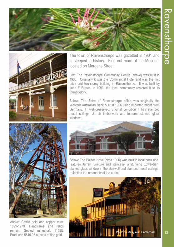
Ravensthorpe
The town of Ravensthorpe was gazetted in 1901 and is steeped in history. Find out more at the Museum located on Morgans Street. Left: The Ravensthorpe Community Centre (above) was built in 1906. Originally it was the Commercial Hotel and was the first brick and two-storey building in Ravensthorpe. It was built by John F Brown. In 1993, the local community restored it to its former glory. Below: The Shire of Ravensthorpe office was originally the Western Australian Bank built in 1906 using imported bricks from Germany. In well-preserved, original condition it has stamped metal ceilings, Jarrah timberwork and features stained glass windows.
Ravensthorpe
13 Photo courtesy Alan Carmichael
Below: The Palace Hotel (circa 1906) was built in local brick and features Jarrah furniture and staircase, a stunning Edwardian stained glass window in the stairwell and stamped metal ceilings reflecting the prosperity of the period.
Above: Cattlin gold and copper mine 1899-1970. Headframe and relics remain. Sealed mineshaft 1159ft. Produced 5849.93 ounces of fine gold.


15
16
Nat
iona
l par
k w
alk
trails
Nat
iona
l par
k w
alk
trai
ls
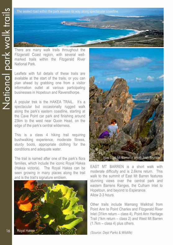
There are many walk trails throughout the Fitzgerald Coast region, with several well-marked trails within the Fitzgerald River National Park. Leaflets with full details of these trails are available at the start of the trails, or you can plan ahead by grabbing one from a visitor information outlet at various participating businesses in Hopetoun and Ravensthorpe. A popular trek is the HAKEA TRAIL. It’s a spectacular but occasionally rugged walk along the park’s eastern coastline, starting at the Cave Point car park and finishing around 23km to the west near Quoin Head, on the edge of the park’s central wilderness. This is a class 4 hiking trail requiring bushwalking experience, moderate fitness, sturdy boots, appropriate clothing for the conditions and adequate water. The trail is named after one of the park’s flora families, which include the iconic Royal Hakea (Hakea victoria). The Royal Hakea can be seen growing in many places along the trail and is the trail’s signature emblem.
16
Atop East Mt Barren – photo Josh Brunner
EAST MT BARREN is a short walk with moderate difficulty and is 2.6kms return. This walk to the summit of East Mt Barren features stunning views over the central park and eastern Barrens Ranges, the Culham Inlet to Hopetoun, and beyond to Esperance. Allow 2-3 hours. Other trails include Mamang Walktrail from Point Ann to Point Charles and Fitzgerald River Inlet (31km return – class 4), Point Ann Heritage Trail (1km return – class 2) and West Mt Barren (1.7km – class 4) plus others. (Source: Dept Parks & Wildlife)
Royal Hakea
The sealed road within the park weaves its way along spectacular coastline

1717
Wildflow
ers and plant diversity
W
ildflowers and plant diversity
The region is reputed to have more plants for its size than any other similarly sized area in the world, apart from remote tropical rainforests. Many of them are endemic and, as yet, not all are documented. There are flowers in evidence all year round but spring is best. Although reaching inland just more than 150km from the coast, the area embraces many different landforms. From ancient mountain ranges to rock hills, vast sand plains and rich red soils, the landscape provides a variation of rocks and soil nutrients to promote a wide variety of plants.
Ravensthorpe Wildflower Show & Spring Festival
This well attended event is held over two weeks in September; some years more than
700 different species are on display. Devonshire teas and Art Exhibitions.
Visit www.wildflowersravensthorpe.org.au
Qualup Bell
17
18
Hop
etou
n
Hop
etou
n
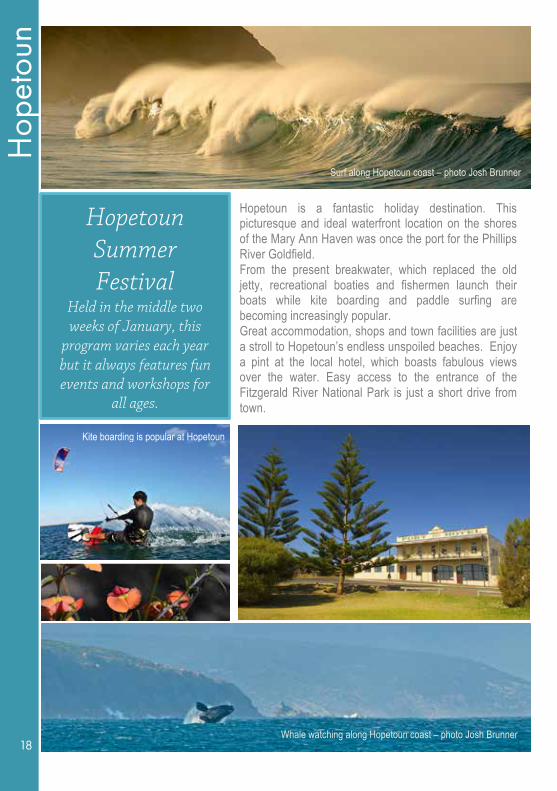
Hopetoun Summer Festival
Held in the middle two weeks of January, this
program varies each year but it always features fun events and workshops for
all ages.
Hopetoun is a fantastic holiday destination. This picturesque and ideal waterfront location on the shores of the Mary Ann Haven was once the port for the Phillips River Goldfield. From the present breakwater, which replaced the old jetty, recreational boaties and fishermen launch their boats while kite boarding and paddle surfing are becoming increasingly popular. Great accommodation, shops and town facilities are just a stroll to Hopetoun’s endless unspoiled beaches. Enjoy a pint at the local hotel, which boasts fabulous views over the water. Easy access to the entrance of the Fitzgerald River National Park is just a short drive from town.
Kite boarding is popular at Hopetoun
Surf along Hopetoun coast – photo Josh Brunner
Whale watching along Hopetoun coast – photo Josh Brunner 18

1919
Hopetoun
H
opetoun
West of Hopetoun, Hamersley Drive and its many good 2WD spur roads give easy road access to 25km of pristine beaches. Within the national park, Barrens, Mylies and West beaches are enclosed by rocky headlands. Cave Point makes a fine lookout for whale watching during the season.
The 2WD coastal road ends with the beautiful Hamersley Inlet and its fine beach, but 4WD vehicles can go further along Telegraph Track to the jewel of a beach at Quoin Head, set between twin narrow headlands. Beyond that the coastal footpath to Point Charles and Point Ann is for experienced bushwalkers equipped to camp overnight. Please contact the Dept. of Parks and Wildlife Ranger for details. East of Hopetoun, the beaches are remarkably accessible by gravel roads. The Southern Ocean Road skirts the shoreline and has several coastal lookouts and access points to beaches, many of which have long limestone shelves and quiet pools for fishing and bathing. It continues to beautiful Mason Point and Mason Bay with its beachfront campsite, then to Starvation Boat Harbour. It has a fine headland, campsites and sheltered boat launching. Continuing east along Springdale Road past Lake Shaster is access to the beautiful Munglinup Beach with headlands, a reef, campsites and the Oldfield River Estuary.
Hopetoun Fishing Competition
Held during the Easter weekend
! !
*PHONE: 08 9838 3438 * EMAIL: [email protected]
BAGGED ICE * BLOCK ICE * BAIT * TACKLE * LOCAL HONEY * WESTCOAST SEAFOOD
* GIBSON SOAK BOTTLED WATER
24 Tamar Street, Hopetoun
Surfing dolphins near Hopetoun - Photo Josh Brunner
!
Post Office * Lotto Fuel * Bait/Tackle * Giftware
Ph: 08 9838 3052 * Fax: 08 9838 3037
24 Veal Street, HOPETOUN 6348
19
!
30 Veal Street, HOPETOUN
Ph: 08 9838 3919 * Fax: 08 9838 3399
OPEN 7 DAYS

20
Fitz
gera
ld R
iver
Nat
iona
l Par
k
Fitzgerald River National Park is one of the larger national parks in Western Australia. It has 330,000 hectares of unspoiled wilderness located on one of the most magnificent stretches of Australian coast. It is one of the largest and most botanically significant national parks in Australia, with approximately 15 per cent of the State’s described plant species. The park protects magnificent scenery and is one of the most flora-rich conservation areas in Western Australia. They include 22 mammal species, 41 reptile species and 12 frogs. The park has more than 200 bird species, including rare species such as the ground parrot, western whipbird and the western bristlebird. There are wallabies, kangaroos, brushtail and honey possums. Much of the rugged scenery of mountains, river valleys and coastline with pristine beaches is easily accessible by 2WD while 4WD tracks are sign posted. The central wilderness area is accessible by foot only.
June 2014 saw the opening of a major $40million upgrade to the park that included sealed road access, camping facilities and recreational sites. Other new facilities include picnic areas, viewing platforms and walk trails to Barrens Beach, Barrens Lookout, Four Mile Beach, East Mount Barren, Point Ann, Hamersley Inlet and Cave Point. All main recreational sites and campgrounds on the eastern side of the park are now easily accessible by a sealed all-weather bitumen arterial road from Hopetoun to Hamersley Inlet. Park fees apply.
Cave Point Viewing Platform
Qualup Bells at Barrens Lookout – Photo Andrew Venning
Quoin Head is accessible by foot or 4WD only
Fitz
gera
ld R
iver
Nat
iona
l Par
k
20

2121
Fitzgerald River National Park
Fitzgerald River N
ational Park
PLEASE REMEMBER:
BE PREPARED: Always carry plenty of fresh water as there are no reliable drinking water supplies within the park. TAKE CARE: Keep your personal safety in mind at all times. Caution is required in any natural environment with potentially hazardous terrain. Fitzgerald River National Park is no exception. STAND BACK from rock headlands and cliff edges. CHOOSE fishing or swimming sites with great care. The Southern Ocean is unpredictable, making rock fishing and swimming especially dangerous. Huge waves and swells can suddenly occur even on calm days. Rocks become slippery when wet. Rip currents are common along the coastline. Wear a lifejacket at all times when fishing from rocks. NO PETS are permitted in the park.
IMPORTANT DIEBACK INFORMATION Dieback is caused by a pathogen, known as Phytophthora cinnamomi, which is lethal to hundreds of plant species. This disease kills plants by destroying their root systems, and threatens many of the park’s plant species. The climate of the south coast favours the spread of dieback, which thrives in warm, moist soil and can easily be spread in mud or soil that adheres to vehicle tyres or bush walkers’ footwear. It is therefore sometimes necessary to close roads and tracks or temporarily restrict access to certain areas. Fitzgerald River National Park is one of the parks least infected by dieback in south-western Australia. With your help it has a chance of remaining so. Bush walkers can help by cleaning mud and soil from their boots before entering a park or reserve, or at the boot-cleaning stations provided at trailhead sites in the park. When driving in the park, it is essential to keep to established roads and tracks and obey all ‘ROAD CLOSED’ signs. By washing the tyres and under-body of your car before and after a trip to a park or reserve, you can help preserve WA’s natural areas.
21 Source: Department of Parks and Wildlife
PARK ACCESS and CAMPING FEES Park entry fees and daily camping permit fees apply. Drive carefully and please note that speed limits apply on all roads within the park. Please contact a Department of Parks and Wildlife Ranger or a department office before your visit to find out about road closures. The Shire of Ravensthorpe runs Hamersley Inlet. The camping ground there is $10.00 per site/night. Gas BBQs and no-water toilets are available. There is no water. Please take all rubbish with you.

22
Mun
glin
up B
each
and
Old
field
Estu
ary
Mun
glin
up B
each
and
Old
field
Est
uary
Offering visitors a number of activities to explore this pristine area, Munglinup Beach and the Oldfield River Estuary is 70km east of Hopetoun and Ravensthorpe. Turn down Springdale Road into Munglinup Beach Road. Driving along the road, you will have picturesque views of the winding Oldfield Estuary before you get to the information bay. The information displayed includes natural cultural heritage, flora, fauna and a map of the Munglinup Beach and the Oldfield Estuary, providing you with an overview of the natural features and the history of the area. There is access to the estuary and deep river for small boats, kayaks or canoes. A nature bush walk trail leads through bush along the river to the ocean. Along the way you can find wildflowers all year round and you also have a good chance to view local wildlife. The Oldfield Estuary is the perfect place to take a kayak or canoe and quietly paddle along to observe the many water birds and untouched bush land. If you enjoy fishing, there are opportunities in the river or from the beach. Looking for a secluded beach? You need not go any further – it’s just around the corner.
Munglinup Beach forms a lagoon that is protected by a reef and here you can swim or snorkel, enjoy the underwater world or just relax on the beach. Nature Protection and Conservation: Visitors to the area are encouraged to help protect and conserve the natural beauty of the area. The local shires, with the community of Munglinup, have a management agreement and plan to look after the campsite at the reef and to minimise environmental damage. The river reserve is protected and adjoined by nature reserves of high conservation value, like the Stokes National Park to the east and Lake Shaster Nature Reserve to the west. The small town of Munglinup has a number of sporting facilities with the roadhouse offering services to the traveller. Munglinup Beach Park offers quality holiday accommodation facilities in natural surrounds. The Park is opposite the Oldfield Estuary. Maps and local area information are available at the reception.
22
Munglinup Beach
Oldfield Estuary

2323
Cam
ping the Fitzgerald Coast
C
amping the Fitzgerald C
oast
The Fitzgerald Coast is brimming with a great selection of camping options. Whether you wish to stay in a more traditional caravan park or set up in a bush camp environment, the choice is yours. Please refer to the map within this brochure for campsite locations within the Fitzgerald River National Park. No pets permitted – park fees apply.
RAVENSTHORPE FACILITIES: A dump point is located in Dunn Street next door to the Ravensthorpe Community Resource Centre. Potable water is available at the Information Bay on Morgans Street opposite the BP service station.
HOPETOUN FACILITIES: A dump point is located at Senna Road opposite Wavecrest Village. Potable water for caravans and campers can be sourced at McCulloch Park near the Hopetoun Jetty end of town.
Hamersley Inlet
KEEP FITZGERALD COAST
BEAUTIFUL Please leave your camping area unspoiled. Picking native plants and wildflowers is prohibited. No fires are permitted between November 1 and January 31. Please observe all fire restrictions. Please camp in designated areas only. Please observe DIEBACK restrictions. RV toilets are not to be emptied into long drops as the chemicals cause interference.
23 Wildlife at Cave Point – photo Rose Pearson

24
Ethe
l Daw
Sce
nic
Driv
e
Ethe
l Daw
Sce
nic
Driv
e
This drive is about 30kms return, leaving from the Ravensthorpe Museum. Set your odometer outside the Museum and head towards Esperance along the South Coast Highway. On the left near the caravan park, is where the old railway station used to be from 1909-1935. Earthworks of platform remain, together with the crane (still in use), two mature Norfolk Island hibiscus trees (pink trumpet flowers in summer). Approx. 100m walk to the East are the remains of the old marshalling yards. The railway ran from Ravensthorpe to Hopetoun only. 3.5km: on the left is the Ravensthorpe Cemetery – 1920 onwards. 5.2km: Picnic area on the right under the Salmon Gums. 6.6km: No.1 Smelter (1904) ruins can be seen on the hill to the left – private property – no admittance. 13kms: Turn right at the Elverdton Road sign onto gravel road. As you proceed up the hill, watch for numerous flowering trees and shrubs. Time of year dictates what is flowering however there’s always something to stop and marvel at, so take your time. 16km: Turn right at Ethel Daw Drive and proceed up a fairly steep hill. 16.7km: Ethel Daw Lookout has 360-degree views over farmland, natural bush, Elverdton and Desmond copper mines, Ravensthorpe town marked by the three large wheat bins, Southern Ocean on a clear day, East Mt Barren, Eyres Range and Mt Drummond to the west and Ravensthorpe Range to the north and northeast. If entering into the bush beware of old mine shafts. 24
Return down Ethel Daw Drive and turn right at the end – continue up Elverdton Road. Going down the hill you will observe pincushion hakeas flowering profusely in autumn and early winter. 19.1km: Turn left onto the Ravensthorpe Hopetoun Road (sealed) to observe the old Elverdton copper mine and gold processing plant finally closed in 1990. STRICTLY NO ADMITTANCE. Twin yate trees, one either side of the road, stand sentinels to guard the historic site. Nothing remains of the old Desmond town site west of the road. TURN AROUND and now head back to Ravensthorpe. A good view now presents itself of Ravensthorpe, the Range and farmland. 24.8km: No sign, but you can take a spur to the right (0.7kms along the track which is rough and will require 4WD in wet weather) and you will see the expansive ruins covering about 20 hectares of the No.2 Smelter, where gold, copper and silver ore were extracted from 1906 to 1918. More details available at the Museum. Return to the sealed road and turn right to head back to Ravensthorpe.
Pincushion Hakea – photo John Carlisle

2525
Business Listings
RAVENSTHORPE Address Phone
Blooz Café Inside IGA, Morgans Street 9838 1008 BP Roadhouse Morgans Street 9838 1047 Dingo’s Dog Kennels and Riley’s Cattery
117 Hopetoun-‐Ravensthorpe Road 9838 1092 0427 381 092
Fitzy’s Bush Camp 17995 South Coast Highway 0419 863 374 0447 908 797
Palace Hotel Morgans Street 9838 1005 Ravensthorpe CRC 28 Dunn Street 9838 1340 Ravensthorpe Museum Morgans Street 9838 1191
Ravensthorpe Motel 12 South Coast Highway 9838 1053 Selena’s Country Kitchen Morgans Street 9838 1163
Shire of Ravensthorpe Morgans Street 9839 0000 4Rivers Plumbing Ravensthorpe 0407 358 983 HOPETOUN Address Phone
Elders Real Estate Hopetoun Veal Street 9838 3100 GoWest Tours Ravensthorpe-‐Hopetoun 9791 4143 Hardware Café 32 Veal Street 9838 3340 Hopetoun Caravan Park 30 Esplanade 9838 3096 Hopetoun Chalet Corner Veal and Canning 9838 1071 Hopetoun CRC 2/46 Veal Street 9838 3062 Hopetoun General Store 24 Veal Street 9838 3052 Hopetoun Holiday Home 0417 987 926 0458 670 036 Hopetoun Ice Works 24 Tamar Street 9838 3438 Hopetoun IGA 30 Veal Street 9838 3919 Hopetoun Motel and Chalet Village Corner Veal and Canning 9838 3219 Port Hotel Veal Street 9838 3053 Range2Reef Realty & Short Stay Holiday Homes
1/19 Veal Street 9838 3081 0428 381 187
Shipwrecked Bakery Shop 1, 26 Veal Street 9838 3715 The Mannor B&B 9 Chambers Street 9838 3328 Wavecrest Village, Bar and Bistro 279 Hopetoun-‐Ravensthorpe Road 9838 3888
MUNGLINUP Address Phone
Munglinup Beach Holiday Park Munglinup Beach Road 9075 1155 Munglinup Roadhouse Tubada Road 9075 1041
BREMER BAY Address Phone
Bremer Bay Caravan Park On the beach at Bremer Bay 9837 4018 Dept Parks and Wildlife Fitzgerald River National Park
PARK RANGERS 0488 451 119 0428 383 060
Business listings
25
26
Acc
omm
odat
ion
and
Mea
ls
A
ccom
mod
atio
n an
d m
eals
!“The Mannor” Bed and Breakfast
Beautiful native garden, walking distance to beaches, shops and cafes. Own bathroom and separate entrance.
9 Chambers Street, HOPETOUN
Phone: (08) 9838 3328
!
Kick bac
k and re
lax!
Affordable accommodation including campsites, caravan/RV park, cabins and self-contained units.
Phone: 9838 3096
30 Esplanade, HOPETOUN
www.hopetouncaravanpark.com
26
Situated on the south coast of Western Australia,
Bremer Bay is a small fishing and holiday resort.
Bremer Bay Caravan Park offers camping and
caravan sites, and a variety of cabins within an
informal, friendly environment. Just 490 kilometres
south-east of Perth, nestled among natural bush,
on the banks of the Wellstead Estuary and the
beaches of the Southern Ocean, you’ll find
Bremer Bay.
Bremer Bay is a thriving town that has a reputation
as an ideal holiday location with a variety of
things to do, such as whale watching (July to
November), wildflowers, fishing, swimming/diving,
four-wheel driving and bushwalking.
Please contact the office on 08 98374018, or email [email protected] to make enquiries – we look forward to hearing from you.
330927A_Bremer bay | 2134.indd 1 19/06/15 9:16 AM

2727
Accom
modation, m
eals & business services
Government services access
Print, fax, scan, email
Tax information
Video conferencing
Secretarial services
Internet access
Room hire & kitchen
Public library
Kids crafts & activities
Professional photo printing
28 Dunn Street Ravensthorpe Open 9-5 Mon to Fri
P: (08)9838 1340 E:[email protected]
www.ravensthorpe.crc.net.au
Accom
modation, m
eals & business services
!
!
Shire of Ravensthorpe “Growing our Community”
Welcome to our unique part of the world.
The Shire of Ravensthorpe offers a variety of services including:
• Department of Transport Driver and Vehicle Services • All Shire enquiries and payments
Opening hours: 9:30am to 4:00pm Monday to Friday
65 Morgans Street, Ravensthorpe
Phone: 9839 0000 Fax: 9838 1282
www.ravensthorpe.wa.gov.au
Proudly supporting the Fitzgerald Coast Tourism Association
!
BOARDING KENNELS FOR YOUR LOVED COMPANION
DINGO’S DOG KENNELS & RILEY’S CATTERY EREMIA CAMEL FARM and WILDLIFE SANCTUARY
Lot 117 Hopetoun-Ravensthorpe Road, Ravensthorpe
Phone: (08) 9838 1092
!
Hotel/Front Bar Facilities 30 Air-conditioned Motel Rooms
with private ensuites Breakfast, Lunch & Dinner available
7 days a week TAB Facilities & Bottle Shop
MORGANS STREET, RAVENSTHORPE
Phone: (08) 9838 1005
Fax: (08) 9838 1200
Palace Hotel Ravensthorpe
BLOOZ CAFÉ MORGANS STREET, RAVENSTHORPE PH: 9838 1008
OPEN: Monday to Friday 7:30am to 3pm. Saturday 8am to 2pm.
HOME MADE PRODUCE BAKED FRESH DAILY!
AMAZING BALCONY VIEWS
Inside IGA near the Visitor’s Information outlet.
Group and Tour Bookings Welcome Centrally located in Main Street opposite PO
Clean and modern parenting and disabled facilities
27
� Accommodation, RV, motorhome, caravan and camp sites
� Pool, tennis court, BBQs, campers’ kitchen, guest laundry
� Bar lounge, bistro dining, bottleshop, takeaway food
� TAB, pool table, large screen TVs, ATM, Free WIFI
� Private bookings: beach and bush adventure group tours
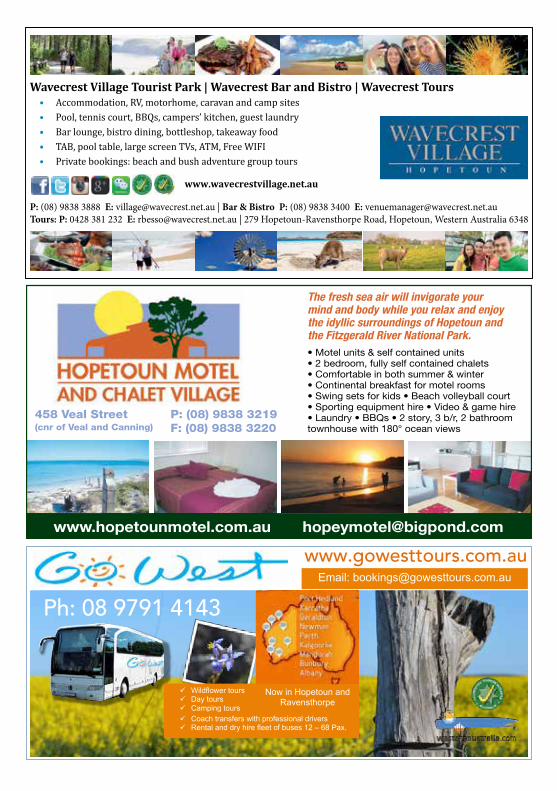
P: (08) 9838 3888, E: [email protected] | P: (08) 9838 3400, E: [email protected]
P: 0428 381 232, E: [email protected] | 279 Hopetoun-Ravensthorpe Road, Hopetoun, Western Australia 6348
� Accommodation, RV, motorhome, caravan and camp sites
� Pool, tennis court, BBQs, campers’ kitchen, guest laundry
� Bar lounge, bistro dining, bottleshop, takeaway food
� TAB, pool table, large screen TVs, ATM, Free WIFI
� Private bookings: beach and bush adventure group tours
P: (08) 9838 3888, E: [email protected] | P: (08) 9838 3400, E: [email protected]
P: 0428 381 232, E: [email protected] | 279 Hopetoun-Ravensthorpe Road, Hopetoun, Western Australia 6348
Wavecrest Village Tourist Park | Wavecrest Bar and Bistro | Wavecrest ToursAccommodation, RV, motorhome, caravan and camp sites
Pool, tennis court, BBQs, campers’ kitchen, guest laundry
Bar lounge, bistro dining, bottleshop, takeaway food
TAB, pool table, large screen TVs, ATM, Free WIFI
Private bookings: beach and bush adventure group tours
P: (08) 9838 3888 E: [email protected] | Bar & Bistro P: (08) 9838 3400 E: [email protected]: P: 0428 381 232 E: [email protected] | 279 Hopetoun‐Ravensthorpe Road, Hopetoun, Western Australia 6348
www.hopetounmotel.com.au [email protected]
458 Veal Street(cnr of Veal and Canning)
P: (08) 9838 3219F: (08) 9838 3220
The fresh sea air will invigorate your mind and body while you relax and enjoy the idyllic surroundings of Hopetoun and the Fitzgerald River National Park.• Motel units & self contained units• 2 bedroom, fully self contained chalets• Comfortable in both summer & winter• Continental breakfast for motel rooms• Swing sets for kids • Beach volleyball court• Sporting equipment hire • Video & game hire • Laundry • BBQs • 2 story, 3 b/r, 2 bathroom townhouse with 180° ocean views
!
!
Ph: 08 9791 4143
www.gowesttours.com.au
Now in Hopetoun and Ravensthorpe
! Wildflower tours ! Day tours ! Camping tours
Email: [email protected]
! Coach transfers with professional drivers ! Rental and dry hire fleet of buses 12 – 68 Pax.