fire effects information system (feis) · the five fire regime parameters most frequently addressed...
TRANSCRIPT
Fire Effects Information System (FEIS)
1
Fire regimes of ponderosa pine (Pinus ponderosa) ecosystems in Colorado: a systematic review and meta-analysis 2019
Citation: McKinney, Shawn T. 2019. Fire regimes of ponderosa pine (Pinus ponderosa) ecosystems in Colorado: a systematic review and meta-analysis. In: Fire Effects Information System, [Online]. U.S. Department of Agriculture, Forest Service, Rocky Mountain Research Station, Missoula Fire Sciences Laboratory (Producer). Available: https://www.fs.fed.us/database/feis/fire_regimes/CO_ponderosa_pine/all.pdf
Abstract
Introduction
Methods
Results
Discussion
Conclusion
References
Appendix
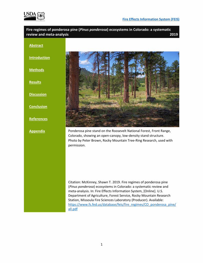
Ponderosa pine stand on the Roosevelt National Forest, Front Range, Colorado, showing an open-canopy, low-density stand structure. Photo by Peter Brown, Rocky Mountain Tree-Ring Research, used with permission.
Fire Effects Information System (FEIS)
2
Contents ABSTRACT ...................................................................................................................................................... 3
INTRODUCTION ............................................................................................................................................. 3
STUDY SYSTEM .......................................................................................................................................... 4
FIRE REGIME PARAMETERS ....................................................................................................................... 6
LITERATURE REVIEW OF FIRE REGIMES IN COLORADO PONDEROSA PINE ECOSYSTEMS ........................ 6
OBJECTIVES ............................................................................................................................................... 9
METHODS .................................................................................................................................................... 10
LITERATURE SEARCH ............................................................................................................................... 10
DATA EXTRACTION AND ANALYSIS ......................................................................................................... 10
Fire Frequency .................................................................................................................................... 12
Fire Severity ........................................................................................................................................ 13
Fire Extent ........................................................................................................................................... 13
Fire Seasonality ................................................................................................................................... 13
Fire-Climate Relationships .................................................................................................................. 14
RESULTS ...................................................................................................................................................... 15
FIRE FREQUENCY ..................................................................................................................................... 15
Concerns about Methodologically-Induced Bias in MFI Meta-Analysis ............................................. 20
FIRE SEVERITY .......................................................................................................................................... 21
FIRE EXTENT ............................................................................................................................................ 23
FIRE SEASONALITY ................................................................................................................................... 25
FIRE-CLIMATE RELATIONSHIP ................................................................................................................. 28
DISCUSSION ................................................................................................................................................. 32
CONCLUSION ............................................................................................................................................... 36
REFERENCES ................................................................................................................................................ 37
APPENDIX .................................................................................................................................................... 43
Fire Effects Information System (FEIS)
3
ABSTRACT
Forest management, especially restoration, is informed by understanding the dominant natural disturbance regime. In many western North American forests the keystone disturbance is fire, and much research exists characterizing various fire regime parameters, although often only one or two parameters are addressed in individual studies. I performed a systematic review of the literature and meta-analysis of the derived data from 26 publications to characterize five parameters of the historical fire regime of ponderosa pine ecosystems in Colorado: fire frequency, severity, extent, seasonality, and climate relationships. Together, these publications suggest a fire regime predominately characterized by moderate to high frequency, low and mixed severity fires that occurred in late summer to fall, with fires occurring in drier than average years that were often preceded by 2 to 3 years of wetter than average conditions. Across all sites, average mean fire interval (MFI) was 21 years (SD = 1.4 years, n = 78 sites) and lengthened with site elevation (r = 0.33, p < 0.05). Low and mixed severity fires accounted for 83% of all observations, and 69% of fires occurred in late summer to fall; fire season was not related to latitude. Geographic region (Front Range and southwestern) was associated with variability in fire regime parameter values, with southwestern Colorado sites having a stronger association with wetter than average conditions in the 3 years preceding fire years and a shorter mean MFI (18 years) relative to Front Range sites (23 years). Evidence of low-severity fire ended abruptly prior to or by the early 20th century (1920) in the fire-scar record from 73 of the 78 sites. Data were insufficient to evaluate contemporary changes in fire severity and extent due to a lack of historical information and inconsistent methodology and reporting. However, one study showed average fire size and total annual area burned increased from 1930 to 2006 across multiple forest types (including ponderosa pine) from southern Wyoming through New Mexico. This meta-analytic approach identified broadscale patterns and variation within and among fire regime parameters, which can be used to understand drivers of vegetation structure and composition and inform forest management aimed at enhancing resilience of fire-adapted forests to disturbance and climate change.
INTRODUCTION
The concept of the fire regime, that there exists a combination of parameters in a given location and over a specific time period that describes the role fire plays in an ecosystem [2,28] is important to understand when applying ecologically based fire management. Fire regimes can be characterized by multiple parameters, including fire frequency, severity, extent, seasonality, and their relationship with climate. How these parameters vary across space and time and with environmental factors (e.g., elevation, latitude, climate conditions) reveals the underlying dynamics that constitute the fire regime for a given ecosystem. Much information on fire regime parameters has been reported following decades of research in a variety of ecosystems and locations. However, typically only one or two parameters are addressed within a given study making it difficult to fully understand the fire regime, given that multiple parameters act on a system concurrently. Furthermore, methods used and results reported differ among individual studies that address the same parameters. Thus, it is

Fire Effects Information System (FEIS)
4
important to understand both the contributing sources of variability in estimates of a given fire regime parameter, and how fire regime parameters relate to one another across space and time. This understanding is difficult to achieve from individual studies. A detailed systematic literature review coupled with a quantitative assessment of the distribution of values reported in individual studies can help explain variability among studies, identify areas where disagreement is largely due to human-induced sources of variation, and reveal patterns of fire regime parameters. Importantly, broad claims made in the literature about the magnitude and characteristics of fire regime parameters or contemporary changes in these values are difficult to evaluate with results from individual studies and can be more thoroughly explored by weighing the evidence from multiple studies within the same ecosystem. STUDY SYSTEM
Ponderosa pine (Pinus ponderosa) is a broadly distributed North American conifer. It ranges across much of western North America, covering approximately 15 million ha, from southern Canada to central Mexico and including 16 states in the western United States (fig. 1). In Colorado, ponderosa pine may be identified as either Rocky Mountain ponderosa pine (P. p. var. scopulorum) or southwestern ponderosa pine (P. p. var. brachyptera). These varietal designations are not common in the literature, and hereafter I use “ponderosa pine” to refer to both. Ponderosa pine forests or ecosystems (where ponderosa pine is either a dominant or subdominant but significant component of the stand) occur on both sides of the Continental Divide in Colorado (fig. 2). On the eastern side of the Continental Divide, ponderosa pine ecosystems occur throughout much of the montane zone (~1,800–2,800 m) along the Front Range of the Rocky Mountains, from the Wyoming border in the north and through the Sangre de Cristo Mountains to the New Mexico border in the south (fig. 2). Associated plant species and typical stand structures vary
Figure 1—Range-wide distribution of ponderosa pine in white, covering roughly 15 million ha and extending from southern Canada to central Mexico including much of the American West. Distribution derived from Little [34] and map created in Data Basin (databasin.org).

Fire Effects Information System (FEIS)
5
with elevation, slope, and aspect. Extensive dry meadows occur within the ponderosa pine forest matrix, particularly on south-facing slopes and at lower elevations, where ponderosa pine occurs in open, ‘park-like’ stands that transition to grasslands below. Rocky Mountain juniper (Juniperus scopulorum) is a common associate on these relatively xeric sites [35]. Gambel oak (Quercus gambelii) occurs as a mid-canopy species in southern Front Range sites on moderate to steep slopes and in a variety of soil conditions [24]. Rocky mountain Douglas-fir (Pseudotsuga menziesii var. glauca; hereafter, Douglas-fir) is a common associate on more mesic sites such as north-facing aspects, and stands are denser [35]. Tree species composition becomes more diverse and ponderosa pine becomes less dominant with increasing elevation, but it can occur as high as 3,077 m on warm, south-facing slopes [23]. At the upper reaches of the montane zone, ponderosa pine mixes with and transitions into Rocky Mountain lodgepole pine (Pinus contorta var. latifolia) forests with components of subalpine fir (Abies lasiocarpa), Engelmann spruce (Picea engelmannii), limber pine (Pinus flexilis), and quaking aspen (Quercus tremuloiodes).
Figure 2—Distribution of ponderosa pine ecosystems in Colorado based on LANDFIRE Biophysical Settings [30]. Numbers indicate approximate location of studies used in this meta-analysis and correspond to references presented in table 1. For studies with more than one research site in close proximity, the approximate midpoint is shown. For studies with more than one site that spanned broad distances, the two distant endpoints are indicated with the same number. The map inset depicts a close up of the northern area where some sites were too close to display separately on the larger map.
Fire Effects Information System (FEIS)
6
On the western side of the Continental Divide, ponderosa pine ecosystems occur primarily in the southwestern part of the state, largely in the San Juan Mountains and Uncompahgre Plateau (fig. 2). Here ponderosa pine occupies a narrower elevational range (~2,100 – 2,900 m) compared to the eastern side, but it is the canopy dominant throughout this elevational zone. Associated tree species vary with elevation and aspect. On relatively xeric sites at lower elevations, ponderosa pine forms pure stands [20] and is generally replaced by Colorado pinyon (P. edulis) - juniper (Juniperus osteosperma, J. monosperma) woodlands below. At mid-elevations, Douglas-fir typically codominates, white fir (A. concolor) and quaking aspen are common associates, and Gambel oak is a major lower canopy component. At higher elevations, these warm, dry mixed-conifer forests transition to dense forests dominated by Engelmann spruce and subalpine fir [27]. FIRE REGIME PARAMETERS
The five fire regime parameters most frequently addressed by fire history studies in Colorado ponderosa pine ecosystems and evaluated here are: 1) Fire frequency – the number of fires per unit time in a given area; reported as the average number of years between successive fires over a given time period (i.e., mean fire interval, hereafter MFI). Fire frequency is the most common parameter reported in fire history studies, and in ponderosa pine ecosystems it is derived from dendrochronological techniques that identify fire scars on annual rings of trees or remnant tree material (logs, snags, etc.) and record the corresponding year of fire. 2) Fire severity – generally indicates the degree of change caused by fire, such as the relative proportion of trees killed within a given area (e.g., the fire perimeter or patches within). Typically classified and reported as high, moderate, low, or mixed. 3) Fire extent – the size of the area burned by an individual fire, the distribution of individual fire sizes, or the total area burned by all fires within a specified time period. 4) Seasonality – the time of year a given fire occurred. In dendrochronological studies, the position of fire scars within annual growth rings approximate what time of year those fires occurred. 5) Fire-climate relationships – climate has a strong influence on fire regimes through its effects on fuel abundance, type, and moisture content. This relationship is examined using an analysis that integrates multiple lines of evidence to infer precipitation conditions during and prior to fire years. LITERATURE REVIEW OF FIRE REGIMES IN COLORADO PONDEROSA PINE ECOSYSTEMS
Several fire history studies in Colorado ponderosa pine ecosystems report a predominance of frequent, low-severity fires across multiple centuries (e.g., [7,12,16,17]), similar to what has been reported for ponderosa pine ecosystems in the American Southwest (e.g., [9,15]). However, several authors suggest regional differences in fire regimes across Colorado ponderosa pine ecosystems. Romme et al. (2003) provide an overview of historical fire regimes of major forest types in the Colorado Front Range and describe a high degree of variability in fire regimes of the ponderosa pine zone [37]. Based on fire history data from 54 sites in the northern Colorado Front Range also examined by Veblen et al. (2000) [49], Sherriff (2004) [39], and Sheriff and Veblen (2007)

Fire Effects Information System (FEIS)
7
[42], they contend that most of the ponderosa pine and Douglas-fir forests in the montane and mixed-conifer zones of the Front Range are characterized by a mixed-severity fire regime and that frequent, low-severity fire is restricted to ponderosa pine ecosystems in the lowest elevations adjacent to grasslands. Sherriff and Veblen (2007) used data from the same 54 sites to model fire frequency classes as a function of environmental characteristics (elevation, aspect, slope steepness and curvature, distance to ravines and grasslands) and related fire frequency to fire severity based on field observations of tree population age structures. They concluded that >80% of northern Front Range ponderosa pine forests had a low- or variable-frequency (MFI > 30 years), mixed-severity historical fire regime with components of stand-replacing and non-stand-replacing fires. The <20% of ponderosa pine forests matching a frequent (MFI < 30 years), low-severity historical fire regime were associated with low elevations (below 2,100 m) [42]. Williams and Baker [50] expanded on the idea that a mixed-severity fire regime dominated ponderosa pine forests in the Front Range and further proposed that the historical mixed-severity regime included a significant amount of high-severity, stand-replacing fires that were larger, on average, than those observed in contemporary times. Fire regimes in southwestern Colorado ponderosa pine forests have been similarly described as highly variable, indicative of a mixed-severity fire regime across space and time. An influence of elevation on fire frequency is evident in some fire history studies where stands at higher elevations generally experienced less frequent fire than stands at lower elevations (e.g., [20]). Fire frequency also varied temporally as evidenced by multi-century chronologies where individual forest stands were marked by periods with frequent fire (e.g., 5-year MFI) and periods with less frequent fire (e.g., 30-year MFI) [20]. Bigio et al. (2010) coupled fire history studies using standard dendrochronological reconstruction techniques with alluvial sediment records and concluded that a low- to moderate- and mixed-severity fire regime likely dominated their study area northeast of Durango for about 2,600 years. They found evidence for both frequent, low-severity fires and infrequent, high-severity fires over this time period [5]. Other researchers are less convinced about the significance of high-severity fires in southwestern Colorado ponderosa pine fire regimes. Brown and Wu (2005) found substantial evidence for frequent surface fires, and did not interpret the existence of even-aged stands as evidence for high-severity, stand-replacing fire, but rather an indication of other disturbance events, such as bark beetle outbreak, followed by optimum climatic conditions for recruitment [8]. This conflicting interpretation of the existence of even-aged stands at least partially reflects the difficulty in reconstructing fire severity over time, where the same evidence can be interpreted as arising from different causal mechanisms. Similar to the uncertainties surrounding historical fire severity reconstruction, historical fire extent is difficult to reconstruct, making it difficult to determine if contemporary fires are larger than historical fires. Even when the size of a contemporary fire is known, determining whether that fire was larger in area than historical fires requires an understanding of the population distribution of fire sizes over a specified historical time period. Given the challenges of reconstructing both severity and extent, it becomes even more difficult to address these two parameters collectively. For example, a key question in fire science and management is

Fire Effects Information System (FEIS)
8
whether contemporary fires are larger and more severe than historical fires. Our lack of this knowledge regarding historical fire size and severity is one reason why fire scientists can come to opposite conclusions that, for example, the 550-km2 Hayman fire in 2002 did [14] or did not [37] have larger high-severity patches than historical fires. Fire extent data from pre-instrumented time periods (i.e., pre-1980) are difficult to acquire and are generally lacking, likely due to the difficulty in accurately estimating the extent of historical, unobserved fires. To estimate fire extent, evidence of fire such as fire scars must be observed over the fire area. This is problematic because fires can fail to scar trees within their perimeter, and because the spatial extent of sampling may not cover the extent of the fire such that trees on the periphery of a larger fire are not sampled, leading to an underestimation in fire’s extent. In addition, evidence of fire is lost over time because trees die and decay, and subsequent fires erase information about prior fires. Human activities can also confound estimates of fire extent. For example, logging, mining, livestock grazing, and fire suppression activities act to alter potential fire extent by altering fuel characteristics. Inter-study comparisons that reveal trends in fire extent with time could be obtained given that most studies confront similar challenges [31]. However, similarity in sampling methodology and results reporting among studies are paramount to overcoming these confounding effects and making legitimate comparisons among studies. Fire regime parameters can be influenced by regional climate at broad spatial scales, and by local landscape characteristics, such as slope and aspect, at finer spatial scales [4]; local topography can, in turn, mediate the influence of climate on fire regime parameters. For example, north-facing slopes typically are more mesic relative to nearby south-facing slopes, and they generally experience less frequent, but more severe, fires [22]. Fire seasonality (the time of year fires burn) is one component of a fire regime that is likely to be driven more by the broadscale influence of climate, than by local topographic factors. However, in north-central Arizona, ponderosa pine forests on both east- and west-facing slopes experienced a majority of fires in summer months; however, west-facing sites had a greater proportion of spring fires than east-facing sites, suggesting some influence of local topographic effects on fire seasonality [21]. For ponderosa pine forests in Colorado, Brown and Shepperd (2001) offered a latitude-seasonality hypothesis, whereby fires in southwestern Colorado occurred primarily during the dry period of May and June and before the onset of summer monsoon moisture during July and August. Conversely, fires in northern Colorado (e.g., the Front Range) primarily occurred in late July, August, and September after grasses and herbaceous fuels cured [7]. Understanding the role of climate variability on the occurrence of fires across space and time has been an active research goal in fire science because it could elucidate the relative contribution of climate or site-level characteristics on fire regimes [25,26,47]. For example, whether fire occurrence is more strongly linked to broadscale climate variability, landscape-level topography, or local site characteristics such as fuel structure can be addressed by evaluating the relationship between variability in climate indices and spatiotemporal occurrence of fire. Sherriff and Veblen [43] found that the relationship between fire years and

Fire Effects Information System (FEIS)
9
climatic variability varied as a function of elevation in Front Range ponderosa pine forests. They proposed that differences in fire frequency and severity between lower and higher elevation sites were due to differences in fuel structures that are linked to differences in patterns of climate variability [43]. At lower elevation sites, fire years occurred 2 years after wetter than average conditions, while at higher elevation sites, this patterns was not observed [43]. In southwestern Colorado ponderosa pine forests, Bigio et al. (2016) also found differences in fire-climate relationships, except the differences were across spatial extents and not elevational gradients; single basin fires were not associated with prior year wet conditions, while fires that occurred in two to three basins were associated with above-average precipitation 2 years prior to the fire year [4]. Colorado ponderosa pine forests have experienced several large, severe fires over the past 3 decades, leading to intense interest and investment in restoration intended to reduce future risk (see Addington et al. (2018) [1] for a thorough discussion of the topic). Understanding the dynamics of historical fire regimes—in particular how the dominant tree species are affected—is important for planning restoration treatments because a primary goal of restoration forestry is to mimic historical tree mortality patterns and, therefore, forest structure at multiple spatial scales [3]. How fire effects vary in relative proportion across a landscape can provide a blueprint by which to guide restoration planning [1]. OBJECTIVES
A wealth of research on the fire ecology of ponderosa pine ecosystems in Colorado has been conducted over the past four decades leading to varying interpretations of the fire regime. To my knowledge, this paper is the first to synthesize and quantify fire regime parameters using a meta-analytic approach to gauge the weight of evidence for and against specific interpretations of these fire regime parameters. The over-arching objective is to describe what the collective research indicates about the distribution of values within and among the fire regime parameters considered, and to address whether and how the fire regime varies with environmental characteristics. Below I outline the specific questions asked for each of five fire regime parameters based on concepts and hypotheses introduced in the literature:
1. Frequency—What is the distribution of historical MFI values, and does it suggest a high-frequency, low-severity fire regime, or a more variable frequency, mixed-severity regime? Does elevation have a strong effect on the fire regime whereby a high-frequency, low-severity fire regime occurs below an elevational level, and a variable-frequency, mixed-severity regime occurs above that level? Does geographic location affect variability in fire frequency? 2. Severity—What is the distribution of historical fire severity classes? To what degree were high-severity fires a component of the historical fire regime, and are contemporary fires more severe than historical fires? 3. Extent—What is the historical distribution of fire size classes; and are fires larger today than the past? For example, has mean fire size increased, and is the larger fire size class a higher proportion of all fires?
Fire Effects Information System (FEIS)
10
4. Seasonality—Was there a dominant fire season in Colorado ponderosa pine forests historically? The season-latitude hypothesis stipulates that fire regimes in southern sites are more influenced by monsoonal moisture patterns than northern sites. Is there support for the seasonal-latitude hypothesis such that the relative proportion of fire scars in each season varies as a function of latitude? 5. Climate relationships—What is the relationship between fire occurrence and precipitation indices; is it uniform throughout the ponderosa pine ecosystems in Colorado, or does it vary with elevation or geographic location?
METHODS
LITERATURE SEARCH
I searched the databases of the Citation Retrieval System of the U.S. Forest Service Fire Effects Information System, Google Scholar, and Web of Science for published and unpublished studies using the following keywords: Colorado, fire regime, fire, ponderosa pine. I then searched the literature cited of relevant studies to find additional related papers. The search process concluded on 13 July 2017, and in total 95 papers were identified for possible inclusion. Papers were reviewed and included if they met the following criteria: research occurred in Colorado, in ponderosa pine ecosystems, addressed at least one of the five aspects of a fire regime (frequency, severity, extent, seasonality, or climate relationships), were empirically based (i.e., numerical results provided based on field observations), and were not entirely simulation, modeling, risk or hazard analyses, speculation, or opinion. Of the 95 papers originally identified, 43 met the inclusion criteria. DATA EXTRACTION AND ANALYSIS
Twenty six of the 43 studies that met the inclusion criteria reported results in a manner that allowed comparison to other studies and contained results that were not previously reported. I extracted results from these 26 studies to use as input data for meta-analysis. I created a database in Excel 2013 for each of the five fire regime parameters, and performed graphical and statistical analyses in R version 3.5.1 [36]. Meta-analyses typically employ approaches to calculate effect sizes as the mean difference between control and treatment groups, the correlation between two continuous variables, or the risk or odds ratio when the response variable is dichotomous. Statistics associated with these effect sizes are usually corrected for sample size and weighted by study-level variance. The type of results reported in fire history studies, however, preclude this approach. For example, before and after control designs do not conform to the retrospective nature of fire history studies (e.g., fire frequency over time), and analyses are often descriptive, reporting the proportion of observations by categorical groupings (e.g., severity classification, seasonality, and climate). Because of these differences, I took a different analytical approach, and for each of the five fire regime parameters, I systematically extracted, combined, and summarized results from the sample of studies that addressed a given parameter (table 1). When a study

Fire Effects Information System (FEIS)
11
included multiple, independent sites, each site-level value was included in the analysis. I included site-level values because typical meta-analysis weighting and standardization of study-level results (e.g., Hedge’s d), require knowledge of both the sample size and standard deviation (or variance), and many studies failed to report one or both of these statistics.
Map number (fig. 2)
Fire Regime Parameter
Reference Frequency Severity Extent Seasonality Climate
1 Bigio et al. 2010 x x 2 Bigio et al. 2016 x x x 3 Brown & Shepperd 2001 x x x 4 Brown & Wu 2005 x x 5 Brown et al. 1999 x x 6 Brown et al. 2015 x 7 Donnegan et al. 2001 x x x 8 Ehle & Baker 2003 x x 9 Fulé et al. 2009 x x 10 Gartner et al. 2012 x x 11 Goldblum & Veblen 1992 x 12 Grissino-Mayer et al. 2004 x x x 13 Korb et al. 2013 x x x 14 Laven et al. 1980 x x NAa Litschert et al. 2012 x 15 Rowdabaugh 1978 x 16 Schoennagel et al. 2011 x x 17 Sherriff 2004 x x x 18 Sherriff & Veblen 2006 x 19 Sherriff & Veblen 2008 x 20 Sherriff et al. 2014 x 21 Veblen et al. 1996 x 22 Veblen et al. 2000 x 23 Wieder & Bower 2004 x x 24 Williams & Baker 2012a x 25 Williams & Baker 2012b x Total 17 7 4 7 12 a Study included all fires throughout the state from 1970-2006; locations cannot be mapped.
Table 1—Fire history studies and their associated fire regime parameters included in the Colorado ponderosa pine fire regime meta-analysis.
Fire Effects Information System (FEIS)
12
Fire Frequency
I extracted site-level mean, minimum, and maximum fire interval values (years), associated time period, elevation (m), and latitude and longitude (decimal degrees) from 17 studies comprising 78 independent sites (table 1). Site elevation, latitude, and longitude were derived using mapping software and were based on site descriptions or maps from the publications when values were not explicitly provided. In cases where there was not enough information to derive site-specific values, I used study-level values provided in the publications. When only minimum and maximum elevation values were given in publications, I calculated the mid-point value and used it as the site elevation. Mean fire interval (MFI) was the primary response variable for the fire frequency meta-analysis. MFI can be calculated and reported in multiple ways using different combinations of the same raw data (e.g., by time period, elevation band, number or percentage of trees affected, etc.). I did not double count results from studies that reported multiple MFI values derived from the same raw data. Likewise, when a study reported MFI values derived using subsets of fire dates based on different filtering criteria (e.g., a minimum number or percentage of trees scarred in a given year), I only included results from the most inclusive level. I did however, include multiple MFI values from a given study if they were from independent sites and or independent time periods (i.e., different raw data). All studies calculated composite MFI (i.e., dates of fire scars from all samples were combined into one crossdated time series). Most studies (71%), representing 64% of site-level MFI values, reported composite MFI values without a filter (‘all-trees’, hereafter). In instances where a study failed to report MFI values for the all-trees category but reported MFI values derived using multiple filter levels, I chose the most inclusive level (least restrictive filter). For example, if a study reported MFI values derived from fire years recorded on at least 10% and 25% of all sampled trees, I included the MFI values based on the 10% filter. Based on these criteria, MFI values from three studies (representing 26% of site-level MFI values) were based on a 10% filter, and MFI values from two studies (representing the remaining 10% of site-level MFI values) were based on fire years recorded on a minimum of two trees (i.e., ‘two-trees’ filter). Some fire history studies used the Weibull distribution to calculate measures of central tendency in fire interval data (usually the median is reported) instead of the normal distribution, from which the arithmetic mean is assumed. Like the normal distribution, the Weibull is a probability distribution for continuous data and it has two parameters, shape and scale. The Weibull is appropriate for modeling the waiting time between events [6], and it has been demonstrated to be a better fit for fire interval data than the normal distribution [18]. Although the Weibull is likely a preferable probability distribution given the nature of fire interval data, too few studies reported Weibull median fire intervals to justify using it over the ubiquitously reported MFI as the response variable for the fire frequency meta-analysis. Moreover, the raw data that is analyzed at the study level (i.e., tree-level, fire intervals) are
Fire Effects Information System (FEIS)
13
different from the raw data I am using in this study (i.e., site-level means), and these latter data more closely match a normal distribution than tree-level interval data. I performed graphical analyses to explore and describe patterns in the fire frequency data. I created a histogram of all the MFI values extracted from the literature. I then plotted MFI value by corresponding site elevation and calculated Pearson’s correlation coefficient between MFI and elevation to assess the strength of the linear relationship between elevation and MFI. I grouped sites into two elevation groups (greater than and less than 2,400 m), plotted them with a histogram, and performed a t-test to determine if mean MFI differed between elevation groups. I constructed box plots of the distribution of MFI values by elevation group to compare median values and data spread. Finally, I grouped sites by two geographic regions in Colorado (Front Range and southwestern), created box plots to explore whether geographic region, and by extension, differences in climatic patterns, explained variation in MFI values, and tested for differences in regional mean MFI values with a t-test. Fire Severity
Seven studies provided quantitative results of the percentage of fire severity observations in low, mixed or moderate, and high groups (table 1). I performed basic calculations using the information provided so that results could be comparable among studies. I plotted mean severity class values and associated standard errors to compare the range of fire severity class observations among studies, and I constructed a table summarizing and comparing the proportion of study-level observations in each fire-severity class, including detailed descriptions of methodology to highlight differences.
Fire Extent
Measures of mean fire extent, or number of fires by size class expressed in areal units (e.g., ha or km2), are required to describe and analyze the distribution of the fire extent parameter. Unfortunately, despite many studies claiming to address changes in fire extent, most did not report any quantitative information on extent of historical fires, some reported on the extent of an individual contemporary fire, and only four studies provided quantitative results of historical fire extent from multiple sites over time (table 1). I described and compared the distribution of fires by fire extent classes for these four studies.
Fire Seasonality
I evaluated fire seasonality by comparing percentages of earlywood fire scars and latewood fire scars, and their ratio (earlywood to latewood). This required that studies reported either the percentage or number of fire scars by seasonal position within annual growth rings. Seven studies (n = 39 sites) met this requirement and formed the basis for the seasonality analysis (table 1). If the number of fire scars by season was reported, I calculated the percentage of these scars among seasons. Variability existed among studies as to which months were included in a given seasonal category. Additional variability existed in how many seasonal categories a
Fire Effects Information System (FEIS)
14
study included, ranging from a maximum of five (dormant, early earlywood, middle earlywood, late earlywood, and latewood) to a minimum of two (earlywood and latewood). To address these differences among studies and align results for comparisons, I collapsed studies with more than two seasonal categories into two categories: earlywood, which included early earlywood and middle earlywood; and latewood, which included late earlywood, latewood, and dormant. In general, the latewood category represented fire scars that occurred from July until the initiation of the following year’s growing season (i.e., mid-summer through fall and winter, and into early spring). The earlywood category represented fire scars from as early as April until mid-July. Thus, some overlap existed for scars that formed in early- to mid-July because of how studies defined their seasons, which was driven by latitudinal effects on the timing of seasons. I calculated the ratio of earlywood to latewood fire scars for each site and plotted these values with a histogram. I calculated Pearson’s correlation coefficient between site- or study-level latitude and earlywood:latewood, and plotted the relationship with a scatter plot. I created three latitude groups (low, mid, and high) defined by equal breaks (1.2° per group) in the range of latitude values for all 39 sites (range = 3.6°, min = 37.13°, max = 40.73°). To evaluate the relationship between latitude and fire seasonality at the coarser, group level, I plotted latitude group data with a box plot, and then calculated the mean earlywood:latewood and its standard deviation for each latitude group and for the overall data set. I also calculated the correlation between latitude and fire seasonality for each of the four studies that reported fire seasonality at multiple sites in an attempt to control for among study variability in methodology and determine if a relationship existed within studies. Finally, I calculated the correlation between site elevation and earlywood:latewood.
Fire-Climate Relationships
The fire-climate relationship was evaluated by selecting studies that performed superposed epoch analysis on the association between fire year and climatic indices for the fire year and each of the 4 years prior. Superposed epoch analysis (SEA) is used to determine whether patterns can be discerned in a time-series consisting of an event and putative explanatory variables. In fire history studies that implement SEA, fire year is the event, and reconstructed climatic indices are the explanatory variables [19]. Twelve studies provided results from a SEA of fire year and climate indices and also met the previously defined inclusion criteria (table 1). The definition of ‘fire year’ varied among the studies, but a majority (69%) defined fire year as either any fire or fires that scarred at least two trees. Five climate indices that are associated with precipitation were used among the 12 studies, and 11 of the 12 studies performed analyses on more than one index. I extracted results for each analysis presented in the 12 papers, resulting in n = 39 results from superposed epoch analyses. Each climate index was derived from various tree-ring chronologies and is therefore a reconstruction of conditions extending back centuries prior to the advent of instrumental measurements. Reconstructed indices include: (1) Palmer drought severity index (PDSI), which
Fire Effects Information System (FEIS)
15
incorporates contemporary temperature and precipitation data to determine whether there was an excess or deficit of water, and therefore, how wet or dry an area was. In fire history studies (n = 14 analyses), PDSI is inferred from reconstructions of summer (June-August) conditions [43]. (2) Tree-ring indices (TRI, n= 13 analyses) directly infer annual precipitation from regional tree-ring chronologies. (3) NINO3 is an index of sea surface temperature from the NINO3 region of the Pacific Ocean (5°N to 5°S, 90°W to 50°W) and is used as a proxy record of the El Niño-Southern Oscillation (ENSO). In fire history studies (n = 7 analyses), NINO3 reconstructions for December-February are used and date back to AD 1408 [11]. (4) Southern Oscillation index (SOI) (n = 3 analyses) is another proxy record for ENSO, and is a measure of the difference in surface air pressure between Darwin, Australia and Tahiti [44]. (5) Pacific Decadal Oscillation index (PDO) is a measure of sea surface temperature anomalies over the North Pacific Ocean. PDO reconstructions (n = 2 analyses) date back to AD 1700 [10]. I extracted results from each SEA on the departure of a given climate index from the running mean for the fire year and for each of the 4 years preceding the fire year. I derived this information from SEA results figures that display index departures as positive or negative relative to the running average (zero line). The direction of departure for each index indicates the same relationship with precipitation; positive departures indicate above average precipitation (wet conditions) and negative departures indicate below average precipitation (dry conditions). I therefore recorded dry, wet, or normal for each of the five years analyzed within each SEA based on a given year’s departure from the zero line. I created stacked bar graphs of the percentage of observations in each of the three precipitation conditions (wet, dry, normal) for the three most commonly used indices (PDSI, TRI, NINO3) and for all indices combined. I then evaluated whether there was a distinction in the temporal pattern of precipitation conditions between sites above and below 2,400 m elevation, and between Front Range and southwestern Colorado sites by constructing and comparing bar graphs of the percentage of observations in each precipitation condition for each of the 5 years and for each group.
RESULTS
Meta-analysis of five fire regime parameters revealed clear patterns and relationships in some parameters and extreme methodological variation in others that obscured underlying phenomena. The number of studies reporting values for each parameter varied, ranging from 17 studies for fire frequency to 4 studies for fire extent (table 1). With the exception of the southern Front Range, study sites were well distributed throughout the range of Colorado ponderosa pine ecosystems (fig. 2), but study sites used to address parameters other than frequency were not well distributed (table 1).
FIRE FREQUENCY
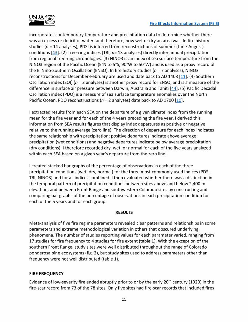
Evidence of low-severity fire ended abruptly prior to or by the early 20th century (1920) in the fire-scar record from 73 of the 78 sites. Only five sites had fire-scar records that included fires

Fire Effects Information System (FEIS)
16
after 1920. Four of these records included fires up to the 1930’s and 1960’s, and the last fire was recorded in 1989. Data were insufficient to perform a time period analysis on MFI. However, the mean MFI of the 5 sites where the fire record ended after 1920 was 2.6 years longer than the mean MFI derived from pre-1920 records (n = 73 sites). Site-level MFI varied among the 78 Colorado study sites, with a 63-year difference between the shortest (3 years) and longest (66 years) MFI (table 2). Despite the broad spread of MFI values, MFI generally had low variation among sites (i.e., standard error of 6.6%), and 85% of sites had MFI values ≤31 years (fig. 3). Indeed, the overall distribution of MFI values was right-skewed by only 4 site-level means that were longer than 46 years, including the 2 longest MFI values of 64 and 66 years (table A1, fig. 3). These 2 longest MFI values represent outliers (i.e., greater than 1.5 x the difference between the 25th and 75th percentile of all observations) of the overall frequency distribution. Both sites were located in the Front Range, included samples from the presettlement time period, and occurred at the upper end (2,650 m) of the elevation range of all sites (min = 1,910 m, max = 3,078 m); only 11 of all 78 sites were at higher elevation, and only 8 of 56 Front Range sites were at higher elevation.
Group n min max mean median SE All sites 78 3 66 21 19 1.4 < 2,400 m 24 3 40 15 14 1.6 > 2,400 m 54 6 66 24 22 1.8
As site-level elevation increased, fire intervals became longer. Elevation and MFI were moderately correlated at the site-level and the relationship was significantly positive (Pearson’s correlation, r = 0.33, df = 76, P < 0.05; fig. 4). Classifying sites into two broad elevation groups (low elevation (<2,400 m) ranged from 1,910–2,385 m, mean = 2,202 m; and high elevation (>2,400 m) ranged from 2,400–3,078 m, mean = 2,602 m) revealed a clearer distinction in the distribution of MFI values by elevation than when evaluated at the site-level (fig. 5). The low-elevation (<2,400 m) group had significantly shorter MFI values (mean MFI of low-elevation sites was 9 years shorter than high-elevation sites) and less variability than the high elevation (> 2,400 m) group (t-test, df =65, t = -3.904, P < 0.05; table 2, fig. 6). Hence, elevation acts to separate Colorado ponderosa pine into distinct statistical populations with respect to MFI. This effect appears robust to the choice of elevation cutoff, although sample sizes were too small to allow for statistical comparisons if the cutoff elevation is below 2,400 m. Nonetheless, the difference between ‘low’ and ‘high’ elevation group mean MFI values was also 9 years when the cutoff elevation was 2,100 m.
Table 2—Summary statistics of site-level mean fire interval (MFI) results from 17 fire history studies in ponderosa pine ecosystems in Colorado. Units are years, except n = number of sites. SE = standard error.
Fire Effects Information System (FEIS)
17
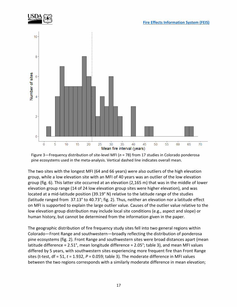
The two sites with the longest MFI (64 and 66 years) were also outliers of the high elevation group, while a low elevation site with an MFI of 40 years was an outlier of the low elevation group (fig. 6). This latter site occurred at an elevation (2,165 m) that was in the middle of lower elevation group range (14 of 24 low elevation group sites were higher elevation), and was located at a mid-latitude position (39.19° N) relative to the latitude range of the studies (latitude ranged from 37.13° to 40.73°; fig. 2). Thus, neither an elevation nor a latitude effect on MFI is supported to explain the large outlier value. Causes of the outlier value relative to the low elevation group distribution may include local site conditions (e.g., aspect and slope) or human history, but cannot be determined from the information given in the paper. The geographic distribution of fire frequency study sites fell into two general regions within Colorado—Front Range and southwestern—broadly reflecting the distribution of ponderosa pine ecosystems (fig. 2). Front Range and southwestern sites were broad distances apart (mean latitude difference = 2.51°, mean longitude difference = 2.05°; table 3), and mean MFI values differed by 5 years, with southwestern sites experiencing more frequent fire than Front Range sites (t-test, df = 51, t = 1.932, P = 0.059; table 3). The moderate difference in MFI values between the two regions corresponds with a similarly moderate difference in mean elevation;
Figure 3—Frequency distribution of site-level MFI (n = 78) from 17 studies in Colorado ponderosa pine ecosystems used in the meta-analysis. Vertical dashed line indicates overall mean.

Fire Effects Information System (FEIS)
18
Figure 4—Relationship between site-level mean fire interval (MFI) and elevation for 78 ponderosa pine sites in Colorado. Figure 5—Frequency distribution of site-level mean fire
intervals (MFI) from study sites below (n = 24) and above (n = 54) 2,400 m elevation. Vertical dashed lines indicate corresponding elevation group means.

Fire Effects Information System (FEIS)
19
southwestern sites were 81 m higher, on average, than Front Range sites (t-test, df = 76, t = - 1.988, p = 0.050; table 3). Although the relationship between geographic region and MFI was not as strong as that between elevation group and MFI, geography did account for variability in the distribution of MFI values (fig. 7). The two sites with the longest MFI (64 and 66 years) were outliers again in the Front Range group distribution. Southwestern sites had a single outlier with a MFI of 46 years that occurred at 2,550 m, and only 5 of 22 southwestern sites were higher elevation than this site.
Longitude (decimal degrees)
Latitude (decimal degrees)
Elevation (m)
MFI (years)
Region mean SD mean SD mean SD mean SD
Front Range 105.43 0.23 39.83 0.63 2,456 221 23 13
Southwestern 107.48 0.60 37.32 0.10 2,537 112 18 10
Table 3—Geographic and mean fire interval (MFI) summary statistics from 17 fire history studies in two regions of ponderosa pine distribution in Colorado.
Figure 6—Variability of site-level mean fire intervals by two elevation groups (< 2400 m, n = 24; and >2400 m, n = 54) from 17 fire history studies on ponderosa pine sites in Colorado. The horizontal line in the middle of each box represents the median value (50th percentile), the ends of the boxes are the first (Q1) and third (Q3) quartiles, which cover the central 50% of the data, and the difference between Q3 and Q1 is the interquartile range (IQR). The notches are an approximation of the 95% confidence interval for the median values. Vertical lines extend to the most extreme data points that are no more than ± 1.5 x IQR, and outliers beyond the lines are individually displayed as circles.
Fire Effects Information System (FEIS)
20
Concerns about Methodologically-Induced Bias in MFI Meta-Analysis
The ideal scenario for any meta-analysis is that the values extracted from the literature were derived in the same manner in each of the selected studies. Although most MFI values were derived using the all-trees approach (i.e., no filter), five were derived from filtered data, which may result in longer mean MFIs, because some shorter values are excluded from analysis. However, a comparison of mean MFI values among the filtered and unfiltered groups suggests that a filter-driven bias was not a concern with these data. While the 10% filter group had the longest mean MFI, the all-trees group had the second longest mean MFI value, and the two-trees filter group the shortest. Furthermore, the relationship among the means of the filter groups appears to be better explained by elevation than by filter strictness. Sites from the two-trees filter group had the lowest mean elevation (2,341 m) and shortest mean MFI (13 years); sites from the all-trees group had intermediate elevation (2,487 m) and mean MFI (20 years); and sites from the 10% filter group had the highest mean elevation (2,516 m) and longest mean MFI (27 years).
Figure 7—Variability of site-level mean fire-return intervals by two geographic regions (Front Range, n = 56; and southwestern, n = 22) from 17 fire history studies on ponderosa pine sites in Colorado. The line in the middle of each box represents the median value (50th percentile), the ends of the boxes are the first (Q1) and third (Q3) quartiles, which cover the central 50% of the data, and the difference between Q3 and Q1 is the interquartile range (IQR). Vertical lines extend to the most extreme data points that are no more than ± 1.5 x IQR, and outliers beyond the lines are individually displayed as circles.

Fire Effects Information System (FEIS)
21
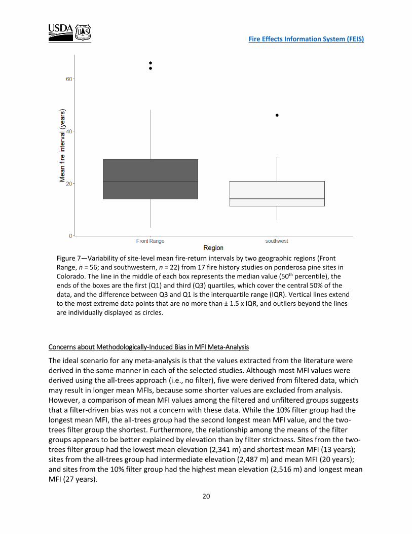
FIRE SEVERITY
The goal of the fire severity meta-analysis was to extract and analyze study results that describe the relative proportion of observations in low, mixed, and high severity classes. The high degree of variation among studies in methodology, design, and classification definition precluded a detailed quantitative evaluation of fire severity class distribution and its relationship with environmental factors (e.g., elevation and geography). Seven studies provided numerical results on fire severity class distribution (table 4). The mixed-severity class had the highest overall mean percentage of observations (observations are sample units, which differ among studies) followed next by the low-severity class, with considerable variation within each fire severity class (fig. 8). Low- and mixed-severity class means combined for 83% of all observations (fig. 8). The high-severity class accounted for more than an insignificant component of the fire regime (class mean 17%; fig. 8), pointing to the periodic occurrence of stand-replacing fire in Colorado ponderosa pine forests. The low-severity class had the greatest range of study-level mean values (ranged from 0% to 90%; table 4), while the high-severity class had the greatest relative variation (least precise estimate) among study-level means (%SE low = 36%, mixed = 28%, high = 49%). The imprecision of fire-severity estimates is further revealed by the complete mismatch between the expected values (severity
Figure 8—Mean percentage of observations (circles with ± standard error bars) of fire severity class from seven fire history studies on ponderosa pine sites in Colorado.
Fire Effects Information System (FEIS)
22
Fire Severity (%) Reference Low Mixed* High n Time Period Region Bigio et al. 2016a 31 69 0 13 Before 1880 Southwestern Ehle & Baker 2003b 90 3 7 80 1540-2000 Front Range Schoennagel et al. 2011c 0 79 21 20 1601-1953 Front Range Sherriff 2004d 72 20 8 86 1700-1920 Front Range Sherriff et al. 2014e 12 88 0 150 1597-1995 Front Range Williams & Baker 2012af 55 24 21 13 1984-2009 Front Range Williams & Baker 2012bg 3 33 64 145 Before 1880 Front Range Mean Severity (%SE) 38 (36) 45(28) 17(49)
a Fire severity estimated within plots through time: • low: ≥1 fire-scarred tree was present within 2 ha of the plot and no distinct cohorts were evident. • mixed: (i) ≥1 fire-scarred tree present and ≥1 distinct cohort evident, or (ii) no fire-scarred trees present,
but ≥1 distinct cohort evident and one surviving tree established prior to the cohort. • high: no fire-scarred trees, ≥1 distinct cohort, and no surviving trees established prior to the cohort.
b Fire severity estimated within plots based on tree mortality and regeneration patterns: • low: no or low mortality and little or no regeneration • mixed: mortality of at least one small group of trees within 10 m of each other • high: high overstory mortality and a subsequent large regeneration pulse
c Fire severity estimated within plots through time, based on relative proportions of trees that survived fires (remnant) and trees that established ≤40 years after fire (establishment): • low: ≥ 80% remnant, ≤ 20% establishment • moderate: 21-79% remnant, 79-21% establishment • high: ≤ 20% remnant, ≥ 80% establishment
d Fire severity estimated for fires within sites based on relative proportions of live trees that survived fire (remnant) and trees that established ≤40 years after fire (establishment), in addition to tree spatial pattern and ring-width changes: • low: ≥ 40% remnant, <20% establishment • moderate: <70% remnant, 20-70% establishment • high: <20% remnant, >70% establishment
e Fire severity estimated at each site using the same criteria as Schoennagel et al 2011, then assigned site-level severity classification of cumulative effects over time. f Fire severity estimated with Monitoring Trends in Burn Severity (MTBS) data of 13 fires > 400 ha. MTBS assigns four severity classes (unburned to low, low, moderate, high) to the area of each fire. Results are percent severity class for combined 13 fires. MTBS severity classes “unburned to low” and “low” were combined as Low here for consistency and comparison with the other studies. g Fire severity estimated using General Land Office survey data to reconstruct historical stand structures, which were used to derive percent severity for 260-ha polygons in a 65,525-ha area, based on the assumptions that tree size is related to tree age and that stand structure and disturbance severity are linked. Polygon severity classified as: • low: (i) mean tree density was < 178 trees ha-1, (ii) the percentage of large trees was > 29.2%, and (iii) the
percentage of small trees was < 46.9%; • mixed: remaining areas (i.e., influenced by fires of moderate-severity or a mosaic of different severities) • high: percentage of small trees was > 50% and percentage of large trees < 20%
Table 4—Fire severity classification results from studies in ponderosa pine ecosystems in Colorado; n = number of sample units.

Fire Effects Information System (FEIS)
23
class means; fig. 8) and study-level means (table 4); no study-level mean class distribution remotely matched expected values. Vastly different study methods made it impossible to compare and detect further patterns of fire severity. Sampling methods ranged from reconstructions of historic forest conditions based on General Land Office Survey data that were then used to reconstruct fire histories and assign severity classes to large areas [51], to assignment of severity classes based on the proportion of remnant (i.e., surviving) and recruitment (i.e., establishing) trees [38-40] (table 4). But even among studies using this structural-based approach, severity classification criteria differed (table 4), complicating comparative estimates. Fire severity studies also differed as to whether the study emphasis was on space or time. Severity of specific fires within a site or plot was estimated in some studies such that a given location could have more than one severity classification over time; an emphasis on time [4,38,40] (table 4). Conversely, other studies estimated the overall severity of a site or plot considering all fires that occurred within a given time frame to assign that location one severity classification; an emphasis on space [13,39] (table 4). FIRE EXTENT
Only four studies provided estimates of historical fire extent, making it difficult to compare with contemporary fire extent; and the variation in sampling methodology and reporting of results made inter-study numerical comparisons difficult (table 1). A single study addressed changes in fire size and area burned in the postsettlement period (1930-2006) across multiple forest types (including, but not limited to, ponderosa pine) in the Southern Rockies Ecoregion, and concluded that average fire size and annual area burned have increased over this period. Laven et al. [31] examined historical fires that occurred between 1708 and 1973 in a 50-ha study area and assigned them into two size categories to evaluate their relative frequency of occurrence. Small fires scarred single trees or small groups of trees and were about 1 ha in size. Large fires scarred trees on at least two opposing slopes and were approximately 25 ha in size. For the total period of analysis, the mean frequency of occurrence was 21 years for small fires and 42 years for large fires. During the settlement era (1840-1905), large fires occurred more frequently with a mean frequency of 16 years, suggesting a positive relationship between human settlement and the incidence of large fires [31]. Mean frequencies were not provided for the presettlement (before 1840) or postsettlement (after 1905) periods, preventing further comparisons. Ehle and Baker [13] estimated mean minimum low-severity fire size within plots and showed a decline in mean minimum fire size from 0.24 ha during the presettlement period (before 1860) to 0.03 ha during the fire suppression period (1915-1999). There was no difference in mean minimum fire size between presettlement and settlement (1860-1914) periods, but the mean minimum fire size during the suppression period was smaller than that of the two earlier time periods.

Fire Effects Information System (FEIS)
24
Sherriff and Veblen [41] estimated minimum fire size of the most recent moderate- to high-severity fires that occurred at each of 22 study sites between 1782 and 1913. Twenty sites had evidence of moderate- or high-severity fires during this 130-year period, and 16 of these fires (80%) occurred during a 21-year period between 1859 and 1880. The overall mean minimum fire size among these sites was 70 ha, with considerable variation around the mean (SD = 54 ha) and a range of 129 ha (min = 6 ha, max = 135 ha). The studies by Sherriff and Veblen [41] and Ehle and Baker [13] sampled overlapping time periods from 1782-1913 and used similar methodology to estimate minimum fire extent, allowing comparisons of mean minimum fire size. However, Ehle and Baker [13] provided only the mean values for the earliest (1760-1860) and latest (1915-1999) time periods, and thus only the earliest time period could be compared with data from Sherriff and Veblen [41]. Mean minimum fire size for 1782-1859 calculated from results in Sherriff and Veblen [41] was 68 ha (n = 11), and is 2 orders of magnitude larger than the estimated mean minimum fire size (0.24 ha) for the corresponding period (1760-1860) in Ehle and Baker [13], and more closely aligns with the ‘large’ fire size category of 25 ha broadly defined by Laven et al. [31]. The study that best addressed changes in fire size suggested increased fire size and area burned over time, although only the postsettlement period is covered [32]. Litschert et al. [32] used spatial data of wildfires from eight national forests in the Southern Rockies Ecoregion [46] that occurred between 1930 and 2006 to classify fire extent into 7 fire-area classes by 20-year intervals. It included fires in multiple vegetation types from southern Wyoming to northern New Mexico, although Colorado fires form the overwhelming majority of fires in the data set (see figure 1 in [32]). This made it difficult to delineate fire extent data by forest type (e.g., ponderosa pine) within Colorado. However, I estimated that approximately 66% of the included fires involved ponderosa pine forests (based on the information in their table 2). A summary of their findings that relates to a change in fire size over time follows (note that I calculated the results for #2 through #6 below from the data presented in their table 1).
(1) The total number of fires in the 2 largest fire size classes (class means 11 km2 and 97 km2) increased from only 2 fires in the earliest period (1930-1950) to 32 fires in the most recent period (1991-2006).
(2) The percentage of fires in the 2 largest size classes relative to the total number of fires increased slightly from the earliest (0.20%) to most recent (0.48%) time periods. The number of large fires increased, but so did the number of all fires.
(3) The total area burned by large fires increased from 22 km2 in the earliest period to 1,986 km2 in the most recent period.
(4) The percentage of total area burned by fires in the 2 largest fire size classes relative to total area burned increased from 52% in the earliest period to 93% in the most recent period.
(5) Mean fire size increased from 0.043 km2 in the earliest period to 0.320 km2 in the most recent period.
(6) The area burned per fire per year increased nearly 6-fold from the earliest period (0.86 km2/fire/year) to the most recent period (5.12 km2/fire/year).
Fire Effects Information System (FEIS)
25
While the smallest fires accounted for the greatest number of fires in all time periods covered, large fires accounted for the greatest area burned [32]. The number of fires in all size classes increased with time, making the increase in the relative proportion of large fires small. Yet, this small relative change still translated to a large increase in area burned. The clearest indication of an increase in fire extent over the 77 years studied is the change in rate of area burned (#6 above). This metric integrates information from the number of fires per size class, the mean area of the size classes, and the mean number of fires per year in each time period, and standardizes it for direct comparison and easy interpretation. For example, it would take about 6 average fires from the 1930 to 1950 time period to equal the size of 1 average fire from the 1991 to 2006 time period. FIRE SEASONALITY
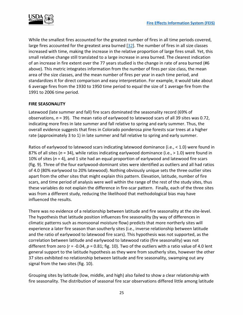
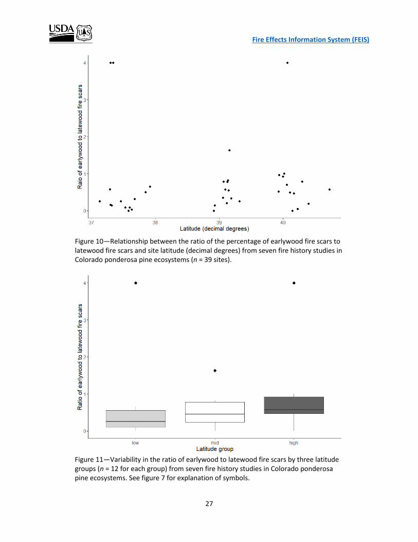
Latewood (late summer and fall) fire scars dominated the seasonality record (69% of observations, n = 39). The mean ratio of earlywood to latewood scars of all 39 sites was 0.72, indicating more fires in late summer and fall relative to spring and early summer. Thus, the overall evidence suggests that fires in Colorado ponderosa pine forests scar trees at a higher rate (approximately 3 to 1) in late summer and fall relative to spring and early summer. Ratios of earlywood to latewood scars indicating latewood dominance (i.e., < 1.0) were found in 87% of all sites (n = 34), while ratios indicating earlywood dominance (i.e., > 1.0) were found in 10% of sites (n = 4), and 1 site had an equal proportion of earlywood and latewood fire scars (fig. 9). Three of the four earlywood-dominant sites were identified as outliers and all had ratios of 4.0 (80% earlywood to 20% latewood). Nothing obviously unique sets the three outlier sites apart from the other sites that might explain this pattern. Elevation, latitude, number of fire scars, and time period of analysis were well within the range of the rest of the study sites, thus these variables do not explain the difference in fire-scar pattern. Finally, each of the three sites was from a different study, reducing the likelihood that methodological bias may have influenced the results. There was no evidence of a relationship between latitude and fire seasonality at the site-level. The hypothesis that latitude position influences fire seasonality (by way of differences in climatic patterns such as monsoonal moisture flow) predicts that more northerly sites will experience a later fire season than southerly sites (i.e., inverse relationship between latitude and the ratio of earlywood to latewood fire scars). This hypothesis was not supported, as the correlation between latitude and earlywood to latewood ratio (fire seasonality) was not different from zero (r = -0.04, p = 0.81; fig. 10). Two of the outliers with a ratio value of 4.0 lent general support to the latitude hypothesis as they were from southerly sites, however the other 37 sites exhibited no relationship between latitude and fire seasonality, swamping out any signal from the two sites (fig. 10). Grouping sites by latitude (low, middle, and high) also failed to show a clear relationship with fire seasonality. The distribution of seasonal fire scar observations differed little among latitude
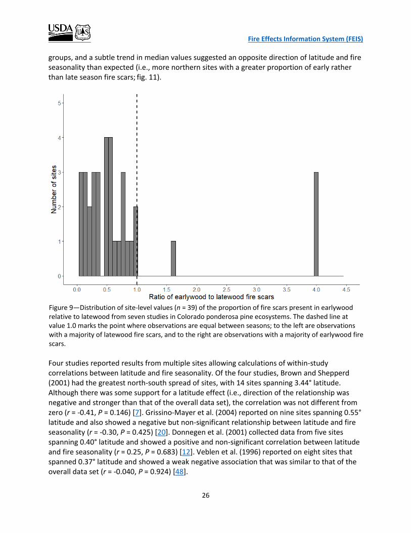
Fire Effects Information System (FEIS)
26
groups, and a subtle trend in median values suggested an opposite direction of latitude and fire seasonality than expected (i.e., more northern sites with a greater proportion of early rather than late season fire scars; fig. 11).
Four studies reported results from multiple sites allowing calculations of within-study correlations between latitude and fire seasonality. Of the four studies, Brown and Shepperd (2001) had the greatest north-south spread of sites, with 14 sites spanning 3.44° latitude. Although there was some support for a latitude effect (i.e., direction of the relationship was negative and stronger than that of the overall data set), the correlation was not different from zero (r = -0.41, P = 0.146) [7]. Grissino-Mayer et al. (2004) reported on nine sites spanning 0.55° latitude and also showed a negative but non-significant relationship between latitude and fire seasonality (r = -0.30, P = 0.425) [20]. Donnegen et al. (2001) collected data from five sites spanning 0.40° latitude and showed a positive and non-significant correlation between latitude and fire seasonality (r = 0.25, P = 0.683) [12]. Veblen et al. (1996) reported on eight sites that spanned 0.37° latitude and showed a weak negative association that was similar to that of the overall data set (r = -0.040, P = 0.924) [48].
Figure 9—Distribution of site-level values (n = 39) of the proportion of fire scars present in earlywood relative to latewood from seven studies in Colorado ponderosa pine ecosystems. The dashed line at value 1.0 marks the point where observations are equal between seasons; to the left are observations with a majority of latewood fire scars, and to the right are observations with a majority of earlywood fire scars.
Fire Effects Information System (FEIS)
27
Figure 10—Relationship between the ratio of the percentage of earlywood fire scars to latewood fire scars and site latitude (decimal degrees) from seven fire history studies in Colorado ponderosa pine ecosystems (n = 39 sites).
Figure 11—Variability in the ratio of earlywood to latewood fire scars by three latitude groups (n = 12 for each group) from seven fire history studies in Colorado ponderosa pine ecosystems. See figure 7 for explanation of symbols.

Fire Effects Information System (FEIS)
28
Thus, site-level latitude, latitude groups, and within study correlations all failed to support a latitude effect hypothesis for fire seasonality in Colorado ponderosa pine ecosystems. Likewise, elevation had no association with fire seasonality (r = 0.089, p = 0.589).
FIRE-CLIMATE RELATIONSHIP
The three most commonly used climate indices (NINO3, Palmer Drought Severity, and Tree Ring Growth) among the 12 studies that analyzed fire-climate relationships via superposed epoch analysis showed a similar pattern in precipitation conditions in each of the 4 years preceding fire years (fig. 12). When results from analyses using these three indices were combined with results from the two less frequently used indices (Southern Oscillation and Pacific Decadal Oscillation) into an “All” group, a similar pattern was evident (fig. 12). Subsequent analyses were thus based on the combined “All” group results.
Figure 12—Comparison of three climate indices used to evaluate the relationship between fire year and antecedent precipitation conditions from 12 fire history studies in Colorado ponderosa pine ecosystems. Y-axis is the percent of all observations in each of three precipitation conditions: average, dry (below average), and wet (above average). Index categories are All, the combination of precipitation indices (n = 39); NINO3, sea surface temperature index (n = 7); PDS, Palmer Drought Severity index (n = 14); and TR, tree ring growth index (n = 13). The four panels represent the number of years preceding a fire year (y-1, one year prior; y-2, two years prior, etc.).

Fire Effects Information System (FEIS)
29
Fire year (year y-0) exhibited the most consistent pattern with 100% of observations (n = 39) showing drier than average conditions during fire years (fig. 13). The year preceding a fire year (y-1) showed equal observations of drier and wetter than average conditions (41% each), while wetter than average conditions were prevalent in y-2 (62%), and more so in y-3 (68%, fig. 13). Most results (57%) showed drier than average conditions 4 years prior to a fire year (y-4, fig. 13). These results support the hypothesis that climatic conditions act as an overriding control on the timing of fires in these ecosystems. Specifically, that fire years are preceded by wetter than average years, potentially increasing rates of biomass production that is later desiccated and burned during drier than average fire years.
Site elevation had no effect on fire-climate relationships during fire years as all sites experienced drier than average conditions in y-0 (fig. 14). Lower elevation sites (i.e., <2,400 m) saw wetter than average antecedent conditions during the 3 years preceding a fire year and
Figure 13—Relationship between fire year and antecedent precipitation conditions from 12 fire history studies in Colorado ponderosa pine ecosystems. Y-axis is the percent of all observations in each of three precipitation conditions: average precipitation, dry (below average), and wet (above average). Precipitation condition is derived from a combination of climate indices including Palmer Drought Severity, tree ring growth, NINO3 sea surface temperature, and others. X-axis is the year relative to fire year (y-0 is fire year, y-1 is year before fire year, etc.).
Fire Effects Information System (FEIS)
30
drier than average conditions 4 years before a fire year (y-4), while higher elevation sites saw wetter than average conditions 2 and 3 years before a fire year (y-2 and y-3) and drier than average conditions 1 year and 4 years before a fire year (y-1 and y-4) (fig. 14). Except for the year preceding a fire year, both elevation groups exhibited the same pattern of wetter than average conditions in y-2 and y-3, and drier than average in y-4. While the two elevation groups showed mostly similar antecedent fire year precipitation patterns, the lower elevation group had a relatively stronger association with wetter conditions and the higher elevation group with drier conditions. Lower elevation sites recorded wetter than average antecedent conditions at a higher proportion relative to higher elevation sites except in y-3. Lower elevation sites experienced wetter than average conditions compared to higher elevation sites in 13% more of y-1 observations, in 31% more of y-2 observations, and in 4% more of y-4 observations. Conversely, higher elevation sites showed wetter than average conditions compared to lower elevation sites in 18% more of y-3 observations (fig. 14). Higher elevation sites experienced drier than average antecedent conditions at a higher proportion relative to lower elevation sites except in y-3. Higher elevation sites experienced drier than average conditions compared to lower elevation sites in 23% more of y-1 observations, and in 29% more of y-2 and y-4 observations. Conversely, lower elevation sites showed drier than average conditions compared to higher elevation sites in 12% more of y-3 observations (fig. 14). The pattern of precipitation conditions preceding a fire year differed between Front Range and southwestern sites in years y-1 and y-4, and were similar in years y-2 and y-3 (fig. 15). Front Range sites exhibited the same pattern as higher elevation sites for the 3 years preceding a fire year, with drier than average conditions in year y-1 and wetter than average conditions in years y-2 and y-3 (fig. 14 and 15). Southwestern sites exhibited the same pattern as lower elevation sites for the 3 years preceding a fire year, with wetter than average conditions in all 3 years (fig. 14 and 15), despite southwestern sites occupying elevations 81 m higher, on average than Front Range sites (table 3). Thus, a confounding effect with elevation is not likely responsible for the similarity in patterns between the regions and elevation groups. Instead, the geographic relationship with fire-climate likely represents a true distinction between southwestern and Front Range ponderosa pine forests. Indeed, the mean differences in the proportion of sites experiencing a given precipitation condition between the two regions (wet = 15% difference, dry = 39% difference) are greater than the differences between the two elevation groups (wet = 6% difference, dry = 14% difference) (fig. 14 and 15).

Fire Effects Information System (FEIS)
31
Figure 14—Relationship between fire year and antecedent precipitation conditions for two elevation groups (< 2,400 m, n = 12 and > 2,400 m, n = 27) from 12 fire history studies in Colorado ponderosa pine ecosystems. See figure 13 for axes descriptions.
Figure 15—Relationship between fire year and antecedent precipitation conditions for two geographic regions in Colorado (Front Range, n = 19 and southwestern, n = 20) from 12 fire history studies in ponderosa pine ecosystems. See figure 13 for axes descriptions.

Fire Effects Information System (FEIS)
32
DISCUSSION
The collection of evidence evaluated in this study points to a historical fire regime in Colorado ponderosa pine ecosystems that was predominantly characterized by high- to moderate-frequency, low- and mixed-severity fires that occurred in late summer to fall, with fires occurring on drier than average years that were often preceded by 2 to 3 years of wetter than average conditions. Although this meta-analysis found that frequent, low- and mixed-severity fires dominate Colorado ponderosa pine ecosystems, similar to that of several local fire history studies (e.g., [7,12,16,17]), a few studies in the northern Front Range suggest that these ecosystems are dominated by less-frequent (MFI ≥ 30 years) or variable frequency, mixed-severity fires (i.e., [40,42]). Sheriff and Veblen (2007) classified 15% of their sampled sites as high-frequency, low-severity, and 85% as low-frequency, high-severity fire regimes. Their model classified 20% of the ponderosa pine zone in the Arapahoe-Roosevelt National Forest (northern Front Range) with an historical high-frequency, low-severity fire regime [42]. Sherriff et al. (2006) classified 8% of their 232 sampled sites as a high-frequency, low-severity fire regime, and 92% as a less-frequent, mixed-severity fire regime. Their model classified 28% of the montane zone of the northern Colorado Front Range as a high-frequency, low-severity fire regime, and 72% of the area as a variable-frequency, mixed-severity fire regime [40]. In contrast, this meta-analysis classifies 75% of Front Range ponderosa pine sites as a high-frequency, low-severity fire regime, if based only on the criterion of MFI ≤ 30 years [40,42]. To assess the relationship between elevation and frequency, I separated low-elevation from high-elevation sites at 2,400 m (based on the distribution of MFI values in my data set), whereas Sherriff et al. [40,42] delimited their sites at 2,100 m. However, this does not explain the broad discrepancy in estimated fire regime class distribution (75% of meta-analysis sites compared to 15% and 8% of sites from the two papers were high-frequency), because meta-analysis sites above 2,400 m had a mean MFI of 24 years, which would still be classified as high frequency. The difference in the characterization of fire regimes between the two studies and this meta-analysis could be due to differences in area sampled or their modeling approach. The two studies used data from their sampled sites to model the distribution of fire regime classes for the broader Front Range. In this meta-analysis, I used study-level data from sites throughout the Front Range to summarize fire regime class distribution. It is possible that the two studies sampled in areas not representative of the broader region, or that their modeling approach produced estimates that differ from a summarization of site-level MFI values. Site-specific MFI values within Colorado ponderosa pine ecosystems are strongly related to elevation, with more frequent fires at lower elevations, where ponderosa pine ecosystems transition to grassland. Variation in the relationship between fire and precipitation conditions is also related to elevation. Drier than average conditions during fire years characterize all sites, regardless of elevation, but lower elevation sites show a strong pattern of wetter than average conditions in each of the 3 years preceding a fire year, while higher elevation sites do not exhibit this pattern. This finding supports the idea that fire occurrence in lower elevation sites is
Fire Effects Information System (FEIS)
33
more strongly associated with growth of fine fuel biomass than by dry conditions needed to desiccate existing fuels [16,43]. A positive relationship between MFI and elevation is well documented by individual studies in both the Front Range [7,38,49] and southwestern Colorado [20]. The results of this meta-analysis confirm that this relationship holds across a large area of the distribution of ponderosa pine ecosystems in Colorado. Geographic location was also associated with variability in fire frequency and climate. Front Range sites had less frequent fire than southwestern sites, although the difference between geographic groups was smaller than the difference between elevation groups. The pattern of the relationship between fire year and climate differed between geographic regions, and the strength of the relationship between fire year and climate was more strongly associated with geography than with elevation. Southwestern Colorado sites experienced a stronger pattern of wetter than average conditions in the 3 years preceding a fire year than did Front Range sites, and this difference was greater than the difference between elevation groups. An interesting pattern emerged from among and within elevation and geographic group comparisons of fire frequency and fire-climate relationships. Both southwestern and low-elevation sites had shorter MFIs relative to their corresponding groups (Front Range and high-elevation, respectively), and both exhibited the same pattern in fire-climate relationships with the 3 years preceding a fire year being wetter than average. Conversely, Front Range and high-elevation sites had longer MFIs than their corresponding group and the same fire-climate pattern of drier than average conditions 1 year before a fire year, and wetter than average conditions 2 and 3 years before a fire year. Hence southwestern and lower elevation sites resembled each other in fire frequency and fire-climate relationships while Front Range and higher elevation sites resembled each other in the same two parameters. This pattern has not been identified or discussed in the literature, to my knowledge, and it was revealed here owing to the meta-analytic approach. Several researchers suggest that low-elevation sites are fuel limited, whereby moist antecedent conditions promote growth of fine fuels that dry and carry fire during drier than average fire years (e.g., [16,43]). It is possible that the similarity in fire-climate relationship between low-elevation and southwestern groups is because southwestern sites conform to a similar fuel-limited model, reflecting the climate-fire-vegetation dynamics of low-elevation sites. Swetnam and Betancourt (1998) found the same pattern in the fire-climate relationship in ponderosa pine ecosystems of Arizona and New Mexico, and they attributed the production of fine fuels to antecedent wet conditions in the 3 years prior to a fire year. They did not find this same pattern in corresponding mixed-conifer forests that generally occupy higher elevations [45]. At higher elevations, drying of fuels is the primary hypothesized mechanism leading to fire, and hence these areas are not fuel limited but rather ‘climate’ limited [33]. Interestingly, southwestern sites were higher elevation on average (mean = 2,510 m), than both the corresponding low-elevation group (mean = 2,194 m) and Front Range group (mean = 2,373 m). Thus, the similarity between southwestern and low-elevation fire-climate patterns is not due to similarity in elevation. Indeed, when low-elevation sites are removed from the southwestern group, the

Fire Effects Information System (FEIS)
34
same pattern and relative percentages in fire-climate relationship hold, with 3 wetter than average years preceding a fire year. It is possible that southwestern Colorado ponderosa pine forests are more influenced by the same regional climate that influences patterns in the American Southwest than by the elevation effect documented in the Front Range [16]. Littell et al. (2009) found similarly broad, regional relationships in fire-climate patterns in an analysis of area burned in the western United States grouped by ecoprovince. They found that most ecoprovinces are more strongly limited either by fuels or by climate, but that there is a range of vegetation types and climates resulting in fire regimes that are limited by both fuels and climate [33]. Colorado ponderosa pine ecosystems may occupy an intermediate space in the fire-climate relationship between fire regimes that are largely fuel-limited and those that are primarily climate-limited, with the relative contribution of each varying spatially. Under this scenario, regional climate would dampen the effect of elevation in the southwestern Colorado fire-climate relationship leading to a more widely distributed fuel-limited system. Farther north in the Front Range, regional climate effects would be lessened, and elevation would play a larger role in driving variability in fire- climate patterns, with higher elevation sites reflecting a climate-limited system. Both of these predictions are generally supported by results of this meta-analysis. One possible explanation for the geographic variation in fire-climate patterns is the difference in precipitation patterns between the two regions, specifically the more pronounced influence of monsoonal moisture in southwestern Colorado relative to the Front Range [7,20]. A geographic effect on fire seasonality was not detected in the meta-analysis. Late-summer to early-fall fire scars accounted for nearly 70% of the fire-scar record in ponderosa pine ecosystems statewide, and evidence for a dominance of fires in late summer to early fall did not diminish when assessed geographically; at the lowest latitude sites, 73% of fire scars indicated late-summer or early-fall fires. Thus, observed geographic differences in precipitation patterns, largely due to late-summer monsoonal rain in southwestern Colorado, did not translate to proportional differences in fire seasonality. Grissino-Mayer et al. (2004) found slightly more (57%) fire scars occurred early in the season (April to mid-June) than late-season in their southwestern Colorado sites (San Juan Mountains). However, they also found a high level of variability among study sites, and an appreciable proportion (31%) of latewood scars (mid-July and after) [20]. This suggests that if a difference exists between the two geographic regions, it is likely subtle, and could be obscured by large among-study differences in methodology and rules defining the classification of fire-scar seasonality. I was unable to extract enough comparable study-level values describing either fire severity or extent to adequately address whether contemporary fires are more severe and larger than historical fires. This is unfortunate because these two concerns are important to forest managers and often form the basis of forest restoration objectives (i.e., reducing the extent and severity of future fires). In general, two issues contribute to the lack of comparable data in the literature: 1) lack of evidence during the historical period, and 2) discrepancy in researcher approach including terminology, classification definition criteria, and methodology.
Fire Effects Information System (FEIS)
35
Due to a lack of historical fire records, fire severity is inferred by existing evidence; fire scars at short intervals in extant trees strongly suggest a low-severity fire regime. Unbiased sampling across all severity classes is difficult because high-severity fires, by definition, kill most of the living trees. Over time, the evidence from dead trees will diminish quicker than the evidence from living trees (i.e., fire scars). However, within some reasonable postfire time period, the probability of detecting evidence from low-, moderate-, and high-severity fires should be comparable. It is within this postfire time period that the lack of comparable severity data in the literature is largely due to differences in researcher methodology and severity classification criteria. For example, of the seven studies that provided usable values, no two had the same definition for all of the severity classes. The discrepancy in researcher approach to fire-severity classification is an important issue in fire ecology research that can be more readily addressed compared to more intractable problems of diminishing evidence with time. The lack of clear evidence regarding a change in fire size over time is due, in part, to the difficulty in accurately estimating the size of historical fires to compare with that of contemporary fires. Historical fire size may be underestimated because information is lost over time (trees dies and decay), fires fail to leave scars on extant trees, and surveys of fire areas may be incomplete [29]. One way to address this sampling bias is to report “minimum fire extent”, and some researchers follow that approach (e.g., [13,43]). Contemporary fire extent can be directly measured with a relatively high degree of accuracy since the 1980s, whereas historical fire extent estimates are likely biased towards underestimating fire size because of the issues discussed above. Thus, even when historical and contemporary values are derived, the comparison will often be between minimum size and maximum size. The difficulty in estimating historical fire sizes leads to discrepancies in methodological approach and terminology when comparing with contemporary fire sizes. At a more fundamental level, these differences make it difficult to address the same specific research question under study. For example, to address the problem of whether contemporary fires are larger than historical fires we could compare: 1) mean area burned or mean fire size between time periods; or 2) the frequency of ‘large’ fires between time periods. However, these two questions require different types of data, and answering one or the other within studies does not allow for a meta-analytic comparison to gauge the strength of evidence for or against a specific claim. Data collection and presentation should be sufficiently similar among studies that are used in a meta-analysis so that they can be grouped to investigate patterns and relationships. I attempted to account for differences in data presentation, and ambiguous or unspecified sampling details among included studies, but a certain degree of uncontrolled variation still exists. This introduced variation should therefore be taken into account when interpreting the resolution and site-specific applicability of this study’s findings; broad patterns of elevation and geographic effects are most appropriate.
Fire Effects Information System (FEIS)
36
CONCLUSION
Given the considerable level of variation in natural systems on which fire regimes operate, describing the characteristics of a fire regime by evaluating multiple parameters provides a more thorough understanding on which to base management decisions. This systematic review and meta-analysis identified key relationships between fire regime parameters and environmental variables, notably, that the dynamics of ponderosa pine fire regimes in Colorado vary along two dimensions: elevation and latitude. The historical fire regime was broadly characterized by high- to moderate-frequency, low- and mixed-severity fires that occurred in late summer to fall, during drier than average years that were often preceded by 2 to 3 years of wetter than average conditions. This range of conditions varied considerably, however, and much of that variation can be explained by site elevation and geographic location. This analysis also revealed shortcomings in certain aspects of fire history research, including a lack of consistency in classification, definitions, sampling approach, and data presentation regarding fire severity, extent, and seasonality. Some issues are largely insurmountable (e.g., the ability to accurately estimate historical baseline conditions) while others can be remedied by a focused effort on consistency in research approach. Considering the importance of fire ecology research to forest management, an ability to determine whether there is a clear signal from fire history research is a valuable goal. Applying restoration that promotes system resilience to fire and climate change requires a solid understanding of the complex drivers of vegetation structure and composition, including keystone disturbances such as fire. The meta-analytic approach to evaluating the plethora of fire research helps accomplish this goal.
ACKNOWLEDGEMENTS
I would like to thank Fire Effects Information System staff members I. Abrahamson, A. Juran, S. Murphy, and K. Zouhar for countless discussions on fire history research and approaches for analyzing, interpreting, and presenting findings, J. Fryer for guidance and assistance in using the Citation Retrieval System, and E. Mason for assistance generating and editing this study’s bibliography. K. Zouhar and I. Abrahamson provided multiple rounds of excellent editorial feedback that improved the paper. K. Zouhar copy edited and formatted the final document. This project would not have been possible without the contribution of all of these people.

Fire Effects Information System (FEIS)
37
REFERENCES
1. Addington, Robert N.; Aplet, Gregory H.; Battaglia, Mike A.; Briggs, Jennifer S.; Brown, Peter M.; Cheng, Antony S.; Dickinson, Yvette; Feinstein, Jonas A.; Pelz, Kristen A.; Regan, Claudia M.; Thinnes, Jim; Truex, Rick; Fornwalt, Paula J.; Gannon, Benjamin; Julian, Chad W.; Underhill, Jeffrey L.; Wolk, Brett. 2018. Principles and practices for the restoration of ponderosa pine and dry mixed-conifer forests of the Colorado Front Range. RMRS-GTR-373. Fort Collins, CO: U.S. Department of Agriculture, Forest Service, Rocky Mountain Research Station. 113 p. [92585]
2. Agee, James K. 1993. Fire ecology of Pacific Northwest forests. Washington, DC: Island Press.
493 p. [22247]
3. Arno, Stephen F.; Fiedler, Carl E. 2005. Restoration objectives, techniques, and economics. In:
Arno, Stephen F.; Fiedler, Carl E., eds. Mimicking nature's fire: Restoring fire-prone forests in the West. Washington, DC: Island Press: 37-53. [69057]
4. Bigio, Erica R.; Swetnam, Thomas W.; Baisan, Christopher H. 2016. Local-scale and regional
climate controls on historical fire regimes in the San Juan Mountains, Colorado. Forest Ecology and Management. 360: 311-322. [89801]
5. Bigio, Erica; Swetnam, Thomas W.; Baisan, Christopher H. 2010. A comparison and integration of
tree-ring and alluvial records of fire history at the Missionary Ridge Fire, Durango, Colorado, USA. The Holocene. 20(7): 1047-1061. [91989]
6. Bolker, Benjamin M. 2008. Ecological models and data in R. Princeton, NJ: Princeton University
Press. 396 p. [93096]
7. Brown, Peter M.; Shepperd, Wayne D. 2001. Fire history and fire climatology along a 5 degree
gradient in latitude in Colorado and Wyoming, USA. Palaeobotanist. 50(1): 133-140. [43826]
8. Brown, Peter M.; Wu, Rosalind. 2005. Climate and disturbance forcing of episodic tree
recruitment in a southwestern ponderosa pine landscape. Ecology. 86 (11): 3030-3038. [90360]
9. Covington, W. W.; Moore, M. M. 1994. Postsettlement changes in natural fire regimes and
forest structure: Ecological restoration of old-growth ponderosa pine forests. Journal of Sustainable Forestry. 2(1/2): 153-181. [30532]
10. D'Arrigo, R.; Villalba, R.; Wiles, G. 2001. Tree-ring estimates of Pacific decadal climate variability.
Climate Dynamics. 18(3-4): 219-224. doi: 10.1007/s003820100177. [93101]

Fire Effects Information System (FEIS)
38
11. D’Arrigo, Rosanne; Cook, Edward R.; Wilson, Rob J.; Allan, Rob; Mann, Michael E. 2005. On the variability of ENSO over the past six centuries. Geophysical Reserach Letters. 32(3): 1-4. doi:10.1029/2004GL022055. [93102]
12. Donnegan, Joseph A.; Veblen, Thomas T.; Sibold, Jason S. 2001. Climatic and human influences
on fire history in Pike National Forest, central Colorado. Canadian Journal of Forest Research. 31: 1526-1539. [43091]
13. Ehle, Donna S.; Baker, William L. 2003. Disturbance and stand dynamics in ponderosa pine
forests in Rocky Mountain National Park, USA. Ecological Monographs. 73(4): 543-566. [47030]
14. Fornwalt, Paula J.; Huckaby, Laurie S.; Alton, Steven K.; Kaufmann, Merrill R.; Brown, Peter M.;
Cheng, Antony S. 2016. Did the 2002 Hayman Fire, Colorado, USA, burn with uncharacteristic severity? Fire Ecology. 12(3): 117-131. [91440]
15. Fulé, Peter Z.; Covington, W. Wallace; Moore, Margaret M. 1997. Determining reference
conditions for ecosystem management of southwestern ponderosa pine forests. Ecological Applications. 7(3): 895-908. [28496]
16. Gartner, Meredith H.; Veblen, Thomas T.; Sherriff, Rosemary L.; Schoennagel, Tania L. 2012.
Proximity to grasslands influences fire frequency and sensitivity to climate variability in ponderosa pine forests of the Colorado Front Range. International Journal of Wildland Fire. 21(5): 562-571. [87367]
17. Goldblum, David; Veblen, Thomas T. 1992. Fire history of a ponderosa pine/doulgas fir forest in
the Colorado Front Range. Physical Geography. 13: 133-148. [91994]
18. Grissino-Mayer, Henri D. 1999. Modeling fire interval data from the American Southwest with
the Weibull distribution. International Journal of Wildland Fire. 9(1): 37-50. doi: 10.1071/WF99004. [93103]
19. Grissino-Mayer, Henri D. 2001. FHX2- software for analyzing temporal and spatial patterns in fire
regimes from tree rings. Tree-ring research. 57(1): 115-124. [93104]
20. Grissino-Mayer, Henri D.; Romme, William H.; Floyd, M. Lisa; Hanna, David D. 2004. Climatic and
human influences on fire regimes of the southern San Juan Mountains, Colorado, USA. Ecology. 85(6): 1708-1724. [50291]
21. Heinlein, Thomas A.; Moore, Margaret M.; Fulé, Peter Z.; Covington, W. Wallace. 2005. Fire
history and stand structure of two ponderosa pine-mixed conifer sites: San Francisco Peaks, Arizona, USA. International Journal of Wildland Fire. 14: 307-320. [55843]
Fire Effects Information System (FEIS)
39
22. Heyerdahl, Emily K.; Brubaker, Linda B.; Agee, James K. 2001. Spatial controls of historical fire
regimes: A multiscale example from the interior West, USA. Ecology. 82(3): 660-678. [38991]
23. Huckaby, Laurie Stroh; Kaufmann, Merrill R.; Fornwalt, Paula J.; Stoker, Jason M.; Dennis, Chuck.
2003. Identification and ecology of old ponderosa pine trees in the Colorado Front Range. Gen. Tech. Rep. RMRS-GTR-110. Fort Collins, CO: U.S. Department of Agriculture, Forest Service, Rocky Mountain Research Station. 47 p. [47081]
24. Kaufmann, Merrill R.; Huisjen, Daniel W.; Kitchen, Stanley; Babler, Mike; Abella, Scott R.;
Gardiner, Todd S.; McAvoy, Darren; Howie, Josh; Page, Douglas H., Jr. 2016. Gambel oak ecology and management in the Southern Rockies: The status of our knowledge. SRFSN Publication 2016-1. Boise, ID: Joint Fire Science Program; Fort Collins, CO: Southern Rockies Fire Science Network. 19 p. [93094]
25. Kitzberger, Thomas; Brown, Peter M; Heyerdahl, Emily K.; Swetnam, Thomas W.; Veblen,
Thomas T. 2007. Contingent Pacific-Atlantic Ocean influence on multicentury wildfire synchrony over western North America. Proceedings of the National Academy of Science. 104(2): 543-548. [66849]
26. Kitzberger, Thomas; Swetnam, Thomas W.; Veblen, Thomas T. 2001. Inter-hemispheric
synchrony of forest fires and the El Nino-Southern Oscillation. Global Ecology and Biogeography. 10(3): 315-326. [41395]
27. Korb, Julie E.; Fulé, Peter Z.; Wu, Rosalind. 2013. Variability of warm/dry mixed conifer forests in
southwestern Colorado, USA: Implications for ecological restoration. Forest Ecology and Management. 304: 182-191. [87568]
28. Krebs, Patrik; Pezzatti, Gianni B.; Mazzoleni, Stefano; Talbot, Lee M.; Conedera, Marco. 2010.
Fire regime: History and definition of a key concept in disturbance ecology. Theory in Biosciences. 129(1): 53-69. [92752]
29. Kulakowski, Dominik; Veblen, Thomas T. 2006. Historical range of variability for forest
vegetation of the Grand Mesa National Forest, Colorado. Golden, CO: U.S. Department of Agriculture, Forest Service, Rocky Mountain Region; Boulder, CO: University of Colorado; Fort Collins, CO: Colorado Forest Restoration Institute. 84 p. [91995]
30. LANDFIRE. 2008. CONUS refresh (LANDFIRE 1.1.0). Biophysical settings layer, LANDFIRE data
distribution site, [Online]. In: LANDFIRE. U.S. Department of the Interior, Geological Survey (Producer). Available: https://landfire.cr.usgs.gov/viewer/ [2017, January 10]. . [89416]

Fire Effects Information System (FEIS)
40
31. Laven, R. D.; Omi, P. N.; Wyant, J. G.; Pinkerton, A. S. 1980. Interpretation of fire scar data from a ponderosa pine ecosystem in the central Rocky Mountains, Colorado. In: Stokes, Marvin A.; Dieterich, John H., tech. coords. Proceedings of the fire history workshop; 1980 October 20-24; Tucson, AZ. Gen. Tech. Rep. RM-81. Fort Collins, CO: U.S. Department of Agriculture, Forest Service, Rocky Mountain Forest and Range Experiment Station: 46-49. [7183]
32. Litschert, Sandra E.; Brown, Thomas C.; Theobald, David M. 2012. Historic and future extent of
wildfires in the Southern Rockies Ecoregion, USA. Forest Ecology and Management. 269: 124-133. [85601]
33. Littell, Jeremy S.; McKenzie, Donald; Peterson, David L.; Westerling, Anthony L. 2009. Climate
and wildfire area burned in western U.S. ecoprovinces, 1916-2003. Ecological Applications. 19(4): 1003-1021. [81459]
34. Little, Elbert L., Jr. 1971. Atlas of United States trees. Volume 1. Conifers and important
hardwoods. Misc. Publ. 1146. Washington, DC: U.S. Department of Agriculture, Forest Service. 320 p. . [1462]
35. Marr, John W. 1961. Ecosystems of the east slope of the Front Range in Colorado. University of
Colorado Studies, Series in Biology: No. 8. Boulder, CO: University of Colorado Press. 134 p. [5724]
36. R Core Team. 2018. R: A language and environment for statistical computing. R Foundation for
Statistical Computing, Vienna, Austria.
37. Romme, William H.; Veblen, Thomas T.; Kaufmann, Merrill R.; Sherriff, Rosemary; Regan, Claudia
M. 2003. Ecological effects of the Hayman- Part 1: Historical (pre-1860) and current (1860-2002) fire regimes. In: Graham, Russell T., tech. ed. Hayman Fire Case Study. Gen. Tech. Rep. RMRS-GTR-114. Ogden, UT: U.S. Department of Agriculture, Forest Service, Rocky Mountain Research Station: 182-195. [91996]
38. Schoennagel, Tania; Sherriff, Rosemary L.; Veblen, Thomas T. 2011. Fire history and tree
recruitment in the Colorado Front Range upper montane zone: Implications for forest restoration. Ecological Applications. 21(6): 2210-2222. [83498]
39. Sherriff, Rosemary L. 2004. The historic range of variability of ponderosa pine in the northern
Colorado Front Range: Past fire types and fire effects. Boulder, CO: University of Colorado. 220 p. Dissertation. [89466]
40. Sherriff, Rosemary L.; Platt, Rutherford V.; Veblen, Thomas T.; Schoennagel, Tania L.; Gartner,
Meredith H. 2014. Historical, observed, and modeled wildfire severity in montane forests of the Colorado Front Range. PLOS ONE. 9(9): 1-17. [89456]

Fire Effects Information System (FEIS)
41
41. Sherriff, Rosemary L.; Veblen, Thomas T. 2006. Ecological effects of changes in fire regimes in
Pinus ponderosa ecosystems in the Colorado Front Range. Journal of Vegetation Science. 17(6): 705-719. [66758]
42. Sherriff, Rosemary L.; Veblen, Thomas T. 2007. A spatially-explicit reconstruction of historical
fire occurrence in the ponderosa pine zone of the Colorado Front Range. Ecosystem. 10(2): 311-323. [71205]
43. Sherriff, Rosemary L.; Veblen, Thomas T. 2008. Variability in fire-climate relationships in
ponderosa pine forests in the Colorado Front Range. International Journal of Wildland Fire. 17(1): 50-59. [70004]
44. Stahle, D. W.; D'Arrigo, R. D.; Krusic, P. J.; Cleaveland, M. K.; Cook, E. R.; Allan, R. J.; Cole, J. E.;
Dunbar, R. B.; Therrell, M. D.; Gay, D. A.; Moore, M. D.; Stokes, M. A.; Burns, B. T.; Villanueva-Diaz, J.; Thompson, L. G. 1998. Experimental dendroclimatic reconstruction of the Southern oscillation. Bulletin of the American Meteorological Society. doi: 10.1175/1520-0477. 79(10): 2137-2152. [93105]
45. Swetnam, Thomas W.; Betancourt, Julio L. 1998. Mesoscale disturbance and ecological response
to decadal climatic variability in the American Southwest. Journal of Climate. 11: 3128-3147. [37431]
46. U.S. Environmental Protection Agency. 2013. Level III ecoregions of the continental United
States. Corvallis, OR: U.S. Environmental Protection Agency, National Health and Environmental Effects Research Laboratory. 1:7,500,000; map, colored. [92749]
47. Veblen, Thomas T.; Kitzberger, Thomas. 2002. Inter-hemispheric comparison of fire history: The
Colorado Front Range, U.S.A., and the northern Patagonian Andes, Argentina. Plant Ecology. 163: 187-207. [43803]
48. Veblen, Thomas T.; Kitzberger, Thomas; Donnegan, Joseph. 1996. Fire ecology in the
wildland/urban interface of Boulder County. A research report to the City of Boulder Open Space. Boulder, CO: University of Colorado. 32 p. [92001]
49. Veblen, Thomas T.; Kitzberger, Thomas; Donnegan, Joseph. 2000. Climatic and human influences
on fire regimes in ponderosa pine forests in the Colorado Front Range. Ecological Applications. 10(4): 1178-1195. [35647]
50. Williams, Mark A.; Baker, William L. 2012. Comparison of the higher-severity fire regime in
historical (A.D. 1800s) and modern (A.D. 1984-2009) montane forests across 624,156 ha of the Colorado Front Range. Ecosystems. 832(5): 832-847. [87397]

Fire Effects Information System (FEIS)
42
51. Williams, Mark A.; Baker, William L. 2012. Spatially extensive reconstructions show variable-
severity fire and heterogeneous structure in historical western United States dry forests. Global Ecology and Biogeography. 21(10): 1042-1052. [87356]

Fire Effects Information System (FEIS)
43
APPENDIX
Mean fire interval (years)
Citation Map Number MFI Min Max Time Period Elevation (m) Bigio et al. 2010 1 12 5 28 1679-1789 2,675 Bigio et al. 2010 1 18 12 33 1789-1879 2,675 Bigio et al. 2016 2 13 4 26 1600-1880 2,550 Bigio et al. 2016 2 14 2 32 1600-1880 2,550 Bigio et al. 2016 2 14 2 24 1600-1880 2,550 Bigio et al. 2016 2 18 2 31 1600-1880 2,550 Bigio et al. 2016 2 30 11 70 1600-1880 2,550 Bigio et al. 2016 2 46 30 36 1600-1880 2,550 Brown & Shepperd 2001 3 8 2 82 1521-1865 2,400 Brown & Shepperd 2001 3 10 2 41 1528-1896 2,615 Brown & Shepperd 2001 3 10 4 41 1514-1908 2,680 Brown & Shepperd 2001 3 16 3 50 1609-1878 2,145 Brown & Shepperd 2001 3 16 3 58 1325-1851 2,165 Brown & Shepperd 2001 3 19 4 54 1608-1805 2,730 Brown & Shepperd 2001 3 20 10 118 1417-1851 2,195 Brown & Shepperd 2001 3 22 3 54 1654-1871 2,620 Brown & Shepperd 2001 3 23 2 72 1598-1846 2,385 Brown & Shepperd 2001 3 26 4 52 1524-1885 2,235 Brown & Shepperd 2001 3 29 11 69 1542-1911 2,615 Brown & Shepperd 2001 3 30 8 79 1654-1908 2,505 Brown & Shepperd 2001 3 40 15 76 1534-1880 2,165 Brown & Shepperd 2001 3 64 24 79 1631-1851 2,650 Brown and Wu 2005 4 14 2 40 1632-1871 2,338 Brown et al. 1999 5 6 2 16 1493-1605 2,310 Brown et al. 1999 5 9 1 29 1285-1493 2,310 Brown et al. 1999 5 10 1 22 1605-1963 2,310 Brown et al. 2015 6 9 3 23 1667-1859 1,999 Brown et al. 2015 6 14 3 36 1667-1859 1,977 Donnegan et al. 2001 7 9 1 51 1781-1920 1,996 Donnegan et al. 2001 7 16 4 76 1456-1920 3,078 Donnegan et al. 2001 7 18 4 76 1727-1920 2,621 Donnegan et al. 2001 7 23 1 88 1587-1920 2,865 Donnegan et al. 2001 7 31 2 116 1675-1920 2,743 Fule et al. 2009 9 24 3 50 1500-1870 2,591 Gartner et al. 2012 10 3 1 19 1675-1920 2,290 Gartner et al. 2012 10 7 1 28 1675-1920 2,378 Goldblum & Veblen 1992 11 8 2 17 1859-1920 2,530 Goldblum & Veblen 1992 11 28 28 28 1920-1989 2,530 Goldblum & Veblen 1992 11 32 3 49 1721-1859 2,530 Grissino-Mayer et al. 2004 12 6 1 18 1645-1880 2,425 Grissino-Mayer et al. 2004 12 7 1 20 1703-1880 2,313 Grissino-Mayer et al. 2004 12 8 1 19 1729-1880 2,500 Grissino-Mayer et al. 2004 12 11 1 27 1679-1880 2,485
Table A1—Fire history studies and their associated site-level values for fire frequency, time period of analysis, and elevation. Map number corresponds to locations in figure 2.
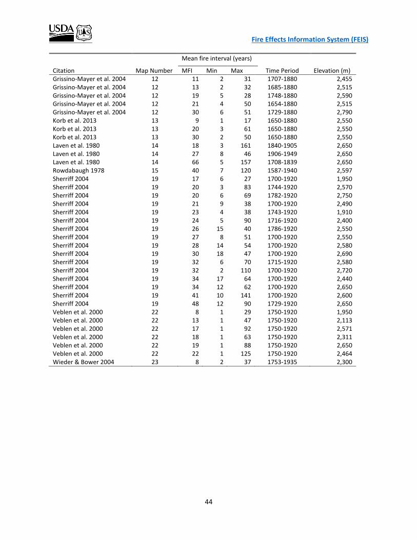
Fire Effects Information System (FEIS)
44
Mean fire interval (years)
Citation Map Number MFI Min Max Time Period Elevation (m) Grissino-Mayer et al. 2004 12 11 2 31 1707-1880 2,455 Grissino-Mayer et al. 2004 12 13 2 32 1685-1880 2,515 Grissino-Mayer et al. 2004 12 19 5 28 1748-1880 2,590 Grissino-Mayer et al. 2004 12 21 4 50 1654-1880 2,515 Grissino-Mayer et al. 2004 12 30 6 51 1729-1880 2,790 Korb et al. 2013 13 9 1 17 1650-1880 2,550 Korb et al. 2013 13 20 3 61 1650-1880 2,550 Korb et al. 2013 13 30 2 50 1650-1880 2,550 Laven et al. 1980 14 18 3 161 1840-1905 2,650 Laven et al. 1980 14 27 8 46 1906-1949 2,650 Laven et al. 1980 14 66 5 157 1708-1839 2,650 Rowdabaugh 1978 15 40 7 120 1587-1940 2,597 Sherriff 2004 19 17 6 27 1700-1920 1,950 Sherriff 2004 19 20 3 83 1744-1920 2,570 Sherriff 2004 19 20 6 69 1782-1920 2,750 Sherriff 2004 19 21 9 38 1700-1920 2,490 Sherriff 2004 19 23 4 38 1743-1920 1,910 Sherriff 2004 19 24 5 90 1716-1920 2,400 Sherriff 2004 19 26 15 40 1786-1920 2,550 Sherriff 2004 19 27 8 51 1700-1920 2,550 Sherriff 2004 19 28 14 54 1700-1920 2,580 Sherriff 2004 19 30 18 47 1700-1920 2,690 Sherriff 2004 19 32 6 70 1715-1920 2,580 Sherriff 2004 19 32 2 110 1700-1920 2,720 Sherriff 2004 19 34 17 64 1700-1920 2,440 Sherriff 2004 19 34 12 62 1700-1920 2,650 Sherriff 2004 19 41 10 141 1700-1920 2,600 Sherriff 2004 19 48 12 90 1729-1920 2,650 Veblen et al. 2000 22 8 1 29 1750-1920 1,950 Veblen et al. 2000 22 13 1 47 1750-1920 2,113 Veblen et al. 2000 22 17 1 92 1750-1920 2,571 Veblen et al. 2000 22 18 1 63 1750-1920 2,311 Veblen et al. 2000 22 19 1 88 1750-1920 2,650 Veblen et al. 2000 22 22 1 125 1750-1920 2,464 Wieder & Bower 2004 23 8 2 37 1753-1935 2,300