finding of suitability for transfer naval … · pico curies per liter (mdh, 1997). structures such...
TRANSCRIPT
FINDING OF SUITABILITYFOR TRANSFER
NAVAL INDUSTRIAL RESERVEORDNANCE PLANT (NIROP)
FRIDLEY, MINNESOTA
Prepared by:
Department of the NavySouthern Division
Naval Facilities Engineering CommandNorth Charleston, South Carolina
April 2004
N91192.AR.000688NIROP FRIDLEY
5090.3a

•/
FINDING OF SUITABILITY FOR TRANSFERNAVAL INDUSTRIAL RESERVE ORDNANCE PLANT
FRIDLEY, MINNESOTA
•
ESOO Review: ----i.'L,'t-;.~#:[d~~~~Receipt Date:Date Review C:;-o::-::m=p:=-;l:::-et=e~d~:~~~Z)r-A;--
Reviewer's Signature:_-4-~::"""~~~~
ES 1 Review: Laurens PittsReceipt Date: 3. 1/ ,Date Review Completed: _:t..p!!:-'.J-=..,Jf-=-f-I"r:=r
Reviewer's Signature:~~~~~~~_
ES 11 Review: David C~well )Receipt Date:~ Gt%;Jt~<:5Y/B-VDate ReviewcomPlet~~Reviewer's Signature:~
ES32 Review: Dan OwensReceipt Date: _--"q.-,-I--"j.L:ltJ!!..t-'::;--;:-;;::r-;;-;;-_~_Date Review Completed: !J-/5J 6<J.. _
Reviewer's Signature: i[::iJ~
Reviewer's Name: Steve BeverlyReviewer's Title: Environmental CounselCode: 09C-sabReceipt Date: ----->;:,~-=~'-{.-_\_=_-l'=--t----:1r-Date Review Completed: -:7'!=,.ofP-''-"-t-fTlf-
Reviewer' s Signature:-=:~~::>o«"""",,,,,,,,,,,~
I have reviewed subject FaST for Environmental completenessand technical sufficiency.I Etrecommend 0 do not recommend forwarding for theCOM's signature (0 See attached comments.)
I have reviewed subject FaST for Environmental Planningc~p~ess and technical sufficiency.I ~ecommend 0 do not recommend forwarding for theCOM's signature (0 See attached comments.)
I have reviewed subject FaST for completeness and technicalsufficiency. .I ~mmend 0 do not recommend forwarding for theCOM's signature (0 See attached comments.)
I have reviewed subject FaST for completeness and technicalsufficiency. .I I2l recommend 0 do not recommend forwarding for theCOM's signature (0 See attached comments.)
I have reviewed subject FOS for legal sufficiency.I recommend 0 do not forwarding for the CO's signature.
o See attached comments.
•
Note: This is a non-BRAC disposal action being administered by the General Services Administration. Thus,SOUTHDIV Real Estate was not included on this review chop.

•
•
1.0
2.0
3.0
FINDING OF SUITABILITY TO TRANSFERNAVAL INDUSTRIAL RESERVE ORDNANCE PLANT
FRIDLEY, MINNESOTA
Purpose
The purpose of this Finding of Suitability to Transfer (FOST) is to document thedetermination made by the undersigned authority, as the responsible Departmentof Defense (000) component official, that the real Property and associatedimprovements comprising the Naval Industrial Reserve Ordnance Plant (NIROPor Property), Fridley, Minnesota, are environmentally suitable for deed transfer toUnited Defense, L.P., (UDLP) the current facility operator, through a negotiatedsale administered by the General Services Administration (GSA). This FOSTreplaces in its entirety, an earlier more generic FOST executed back on 13January 1998 in connection with the contemplated disposal of this same facility.
Description of Property to be Transferred
As further detailed in attached Exhibit A, the NIROP encompasses 80.35 acresof land, of which, approximately 36 acres are covered by the facility's MainIndustrial Building. That building extends onto adjacent industrial Property ownedby UDLP. The facility was builtin 1940 and the Navy acquired the portion of thephysical plant it currently occupies in 1947. Several small buildings, includingBuilding 52/53 (groundwater extraction system enclosure); Building 13 (guard
. house); Building 51 (storage building); Building 50 (warehouse); Building 37(armament building); Building 34 (liquid propane tanks control room); Building 58(munitions bunker), and Building 59 (soil vapor extraction system enclosure) arelocated adjacent to the Main Industrial Building. The NIROP is situated north ofthe Minneapolis/St. Paul metropolitan area within the boundaries of the City ofFridley, Minnesota.
Past and Proposed Future Use of the Facility
Since the initiation of industrial operations in 1940, the NIROP has been usedprimarily for the production of gun mounts and guided missiles launching systemsfor the Department of Defense (000). It is anticipated that UDLP will continue touse the Property for similar industrial manufacturing / commercial purposes.
4.0 Environmental Condition of the Property
a. Hazardous Substance Contamination
The NIROP is a National Priorities List (NPL) site. For environmental investigationand remediation purposes the NIROP was divided into three Operable Units

•(OUs). OU #1 encompasses groundwater contamination. OU #2 encompassesunsaturated source contamination outside the Main Industrial Building. OU #3encompasses source contamination beneath the Main Industrial Building andsaturated source contamination underneath and outside that building. TheRemedial Investigations ("RI's") for OU #1, OU #2 and OU#3 have beencompleted and all available information concerning the past storage, release ordisposal of hazardous substances on the NIROP as collected through recordsearches, aerial photographs, personnel interviews and on-site sampling andvisual inspections conducted is contained in the facility-wide EnvironmentalBaseline Survey for Transfer - October 1997 (EBST) prepared by the Navy incontemplation of the disposal of this particular facility. A copy of the EBST hasbeen provided to GSA and UDLP representatives.
As documented in the EBST, trichloroethene (TCE) was the only hazardoussubstance found to have been released or disposed of in excess of its reportablequantity under 40 CFR Part 302. However, several other volatile organiccompounds, semi-volatile organic compounds, metals, and PCBs have also beendetected in soils and groundwater at the facility. Groundwater remediation(currently a pump and treat system) to address both the TCE and these othercontaminates in groundwater will continue until cleanup goals have beenachieved. With respect to surface and subsurface soil contamination' at theNIROP, the Navy intend~ to impos,e certain land use controls (LUCs) via the deedof conveyance on certain portions of the NIROP (Le., Designated RestrictedAreas A-3, A-4 and former plating shop) shown in the three surveys comprisingExhibit B to this FOST. Application of these LUCs will preclude unacceptablefuture risks to human health and the environment and the Navy has obtainedregulatory concurrence with this remedial approach. Interim LUCs will also beimposed via the deed of conveyance to preclude exposure to contaminatedgroundwater beneath the facility until applicable cleanup goals have beenachieved.
b. Petroleum USTs / Contamination
A total of twelve (12) underground storage tanks (USTs) were formerly in use atthe NIROP. All twelve have since been removed. As documented in the EBST,seven (7) of those tanks had leaks associated with them. Cleanup actions wereundertaken and all seven sites have received closure certifications from MPCA.
c. DoD Condition of Property Classification
. The EBST documents that in 1997, approximately 44.35 acres of the NIROPqualified for DoD Property Condition Classification Category 3/Yellow (areaswhere necessary removal or remedial actions are underway but have not yetbeen completed) with the remainder qualifying for Category 4/Red (areas where
2

•
•
required remediation has not yet been planned or implemented or where thecondition of the Property does not otherwise satisfy applicable regUlatoryrequirements). Because of the initiation of subsequent remedial efforts, the entireNIROP now qualifies for classification under Category 3Nellow. Cleanup workcontinues for the entire facility under the Navy's Installation Restoration (lR)Program and the terms of a Federal Facility Agreement (FFA) which the Navyexecuted back in March of 1991 with U.S. Environmental Protection Agency(EPA) and the Minnesota Pollution Control Agency (MPCA). There are currentlyno environmental conditions on the NIROP which would preclude its transfer andreuse as an industrial facility assuming the application of those LUCs describedlater on in this document
d. Other Environmental Matters
1. Ordnance
There is no evidence of ordnance treatment and/or disposal activities havingever been conducted at the NIROP.
2. Asbestos
In 1990-1991 timeframe an asbestos survey was conducted on NIROPProperty. In 1995, an additional survey was conducted on UDLP Property.The plant prioritiied each surveyed area identified in both reports based onpotential for exposure and condition of the asbestos-containing material(ACM) and developed an abatement plan. Abatement projects since theimplementation (October 1996) of the Plant Abatement Plan have consistedof the removal of piping insulation, floor tiles, and ceiling tiles.Approximately 7,385 pounds of ACM were removed in 1996, approximately104,000 pounds were removed in 1997, and approximately 5,800 poundswere removed in 1998. Although ACM remains at the NIROP facility, it isbelieved that pursuant to DoD policy, all accessible, damaged and friableACM has been repaired or removed. UDLP should be advised of the needto properly manage all remaining ACM to prevent future risks to humanhealth or the environment.
3. Polychlorinated Biphenyls (PCBs)
PCB-containing items at the NIROP include oil-filled electrical equipmentand hydraulic systems. There are no regulated PCB items (items containingmore than 50 parts per million (ppm) PCBs) at the plant. The majorelectrical distribution system components at the plant consist oftransformers, capacitors, circuit breakers, and switchgears. Currently thereare no oil-filled transformers at the facility; there are twelve dry transformerslocated within nine substations. Formerly there .were three PCB-
3

•
•,~
•
contaminated transformers located in substation No.5, however, these unitswere removed from service and disposed of in 1989. Also, there were threePCB-contaminated transformers formerly located in substation NO.4. Theseunits were disposed of in 1979. There were no reported uncontrolledreleases of transformer oil to the environment. All regulated PCB capacitorsknown to be present at the plant (104 units) were removed from service in1988.
Historically, there were four reported releases of PCB dielectric fluid fromcapacitor units. All releases were of 0.5 kg or less of PCB oil and allreleases were contained within the cabinet or secondary containmentstructure. In 1987/1988, Navy owned equipment (SIP Jig bore, grinders,lathes, drills, etc.) containing hydraulic systems were sampled and the oilanalyzed for PCBs. Only one unit contained PCBs (15 ppm), and this unit isnot regulated. All known equipment containing hydraulic systems has beentested for PCBs. Historically, PCB and PCB-contaminated equipment werestored for removal in concrete tanks, which were covered with concrete lidsand temporarily sealed. Storage was discontinued in 1989 when theremaining PCB capacitors and PCB-contaminated transformers weredisposed of. There were no reported spill or leaks associated with thetemporary storage area. During the OU #3 Remedial Investigation, PCBswere detected in the subsurface soils beneath the main NIROP building butat concentrations below Minnesota's Soil Reference Values for eitherresidential or industrial exposure.
4. Radon
A radon survey has not been conducted at the NIROP. The MinnesotaDepartment of Health (MDH), based on information provided by EPA,classifies Anoka County as a medium radon potential area. Thisclassification was based on radon data which indicated that between 10 to20 percent of tested homes had radon levels above the EPA's guideline of 4pico curies per liter (MDH, 1997). Structures such as family housing units,hospitals, schools, and child care centers, typically included in radonsurveys, are not present at the facility and there is currently no regulatoryrequirement for radon testing and abatement in industrial buildings.
5. Lead-Based Paint
Because the NIROP was built before 1978 when the Federal ban on use oflead-based paint was instituted, it must be assumed that lead-based paint ispresent on the interior and exterior surfaces of each structure located on the
4

•
•
5.0
Property. By way of the EBST and transfer deed, UDLP will be providedwith notice of the potential presence of such paint within, or on the exteriorsurfaces of all existing facilities at the NIROP so that appropriate LBPhazard prevention measures may be implemented as needed to precludepotentially harmful worker / facility invitee LBP exposures.
Requirements Applicable to Property Transfer
a. National Environmental Policy Act (NEPA) Compliance
On 12 January 1998, a Categorical Exclusion (CATEX) determination was madeand executed by the appropriate Navy official in satisfaction of NEPArequirements pertaining to the transfer of this facility to GSA for disposaL GSAwill ensure compliance with all NEPA requirements applicable to its subsequentdeed transfer of the NIROP to UDLP.
b. Hazardous Substance Notice:
In compliance with CERCLA Section 120(h)(3)(A)(i) and 40 CFR Part 373, alisting of those specific hazardous substances which it is known, based upon acompete search of agency records, were stored for one year or more, released ordisposed of in excess of their respective reportable quantities under 40 CFR Part302 and a description of all remedial actions taken to address such releasesand/or disposals is provided in attached Exhibits C and D which will beappended to the transfer deed.
c. CERCLA Access Clause:
In accordance with CERCLA Section 120(h)(3)(A)(iii), the transfer deed will containa provision granting the Navy, its officer, agents, employees and contractors andsubcontractors a right of access to all portions of the Property for purposes ofcompleting all necessary environmental investigation,. remediation, monitoring orother response actions. This reservation shall include the right of access to anduse of, to the extent permitted by law, available utilities at reasonable cost to theNavy. Pursuant to this same access r~servation, the Navy will grant to EPA andthe MPCA, their officers, agents, employees, contractors and subcontractors theright to enter upon the Property to conduct, or to oversee the Navy's conduct of, allsuch necessary environmental investigation, remediation monitoring or otherresponse action activities on the Property. All such entry(ies) by the Navy, EPA orMPCA shall be coordinated with UDLP and its successors, assigns, and/or tenantsin order to minimize any interruptions with their use of the facility.
5

•
•
d. Land and/or Groundwater Use Controls
To ensure future protection of human health and the environment from residualsoils and groundwater contamination, certain land and groundwater use controls(LUCs) will be implemented on the NIROP via transfer deed provisions as furtherdescribed below:
1. Categorical Use -Restriction:
The transfer deed will require that UDLP covenant on behalf of itself, its lessees,licensees, successors and assigns to only use the Property for industrial orrestricted commercial uses unless the EPA and MPCA determine that theconcentrations of hazardous substances in the soils on the Property allow for lessrestrictive uses. Permissible industrial uses shall include, but not be limited to, thefollowing types of uses: public utility services, rail and freight services, raw storagefacilities, refined material storage facilities, and manufacturing facilities engaged inthe mechanical or chemical transformation of materials or substances into newproducts. Permissible restricted commercial uses shall include those whereaccess or occupancy by non-employees is less frequent or is restricted, including awide variety of uses, ranging from non-public access and both outdoor and indooractivities (e.g., large scale warehouse operations), to limited public access andindoor worker activities (e.g., shopping mall, retail outlet, bank, dentist office).Strictly prohibited uses under either category shall include any child care or preschool facility, playground, any form of housing, churches, social centers,hospitals, elder care facilities or nursing homes.
2. Well Installation / Groundwater Extraction Restriction:
The transfer deed will require that UDLP covenant on behalf of itself, its lessees,licensees, successors and assigns not install any water supply wells nor extractany groundwater from beneath the Property without prior written approval fromthe EPA, MPCA and the MDH. Notwithstanding that restriction, treatedgroundwater meeting State surface water requirements may be used for 'noncontact cooling purposes if it is subsequently discharged into the MississippiRiver. This restriction shall also not apply to UDLP's installation of any newgroundwater monitoring wells on the Property upon request of the Navy, wherethe Navy has already obtained all necessary regulatory approvals for suchinstallations.
3. Soil Disturbance Restrictions:
a. Soils Beneath Main Industrial Building
6

•
•
The transfer deed will require that UDLP covenant on behalf of itself, its lessees,licensees, successors and assigns not to disturb any soils beneath the concretepit floor (approximately 8 to 12 feet below floor grade) where metal finishingoperations previously occurred at the former Plating' Shop within the MainIndustrial Building without the prior written approval of the EPA and MPCA.Moreover, any soils excavated from that area as will be described in the deed,may not be removed from the Property unless such removal is approved in writingin advance by the EPA and MPCA at the time such removal and disposal isproposed.
b. Soils Outside Main Industrial Building
The transfer deed will also require that UDLP covenant on behalf of itself, itslessees, licensees, successors and assigns not to disturb any soils deeper than 3feet below ground surface within a second DRA lying outside the footprint of theMain Industrial Building without the prior written approval of the EPA and MPCA.Also any soils excavated from this DRA may not be removed from the Propertyunless such removal is approved in writing in advance by the EPA and MPCA atthe time such removal and disposal is proposed.
4. Non-Interference Restriction:
The transfer deed will require that UDLP covenant on behalf of itself, its lessees,licensees, successors and assigns not to unreasonably hinder or prevent theNavy from constructing, upgrading, operating, maintaining and monitoring anygroundwater treatment facilities and groundwater monitoring network or engage inany activity that would (i) cause the Navy to violate any Health and Safety Planput into effect and directly related to its' performance of the Federal FacilitiesAgreement at the Property or (ii) otherwise disrupt or hinder further remedialinvestigation, response actions or oversight activities related to its performance ofFFA related activities on the Property.
5. Required LUC Related Notices / Certifications:
a. Desired Change in Land Use
The transfer deed will require that UDLP covenant on behalf of itself, its lessees,licensees, successors and assigns to provide advance written notice to the EPA,MPCA and the Navy of its desire to use the Property for anything other thanindustrial or restricted commercial use. Such notice shall include a description ofits plans for undertaking any environmental investigation and/or cleanup activitiesnecessary to permit such a change in land usage. Grantee on behalf of itself, itslessees, licensees, successors and assigns ensure that such activities will not
7
•
•
conflict with or adversely affect any ongoing remedial systems or futureinvestigative or remedial activities to be undertaken by the Navy on the Property.
b. LUC Annual Compliance Certification
The transfer deed will require that UDLP covenant on behalf of itself, its lessees,licensees, successors and assigns to provide annual written certifications byMarch 1st of each year to the EPA, MPCA and the Navy regarding continuedcompliance with those LUCs implemented through deed recordation for as longas such LUCs remain in place to ensure adequate protection of human health andthe environment. Such annual certifications shall be based upon annual physicalinspections of the Property and shall be provided using Exhibit E to this Fost.
6.0 Environmental Agreements I Orders I Permits
In addition to the FFA executed between the Navy, EPA and the MPCA, theNIROP currently has the following regulatory permits: a Resource Conservationand Recovery Act (RCRA) permit (Permit No. MN3 170 022914), issued byMPCA; a National Pollutant Discharge Elimination (NPDES) permit (Permit No.MN 0000710) also issued by MPCA; a Water Appropriations permit (Permit No.92-6127) and approximately 50 individual Well Maintenance permits issued by theMinnesota Department of Natural Resources and an Industrial WastewaterDischarge permit (Permit Nos. 0081) and Special Discharge permit (No. 2154)issued by the Metropolitan Council of Environmental Services. A Clean Air ActTitle V air emissions permit application has also been provided to the MPCA, buta permit has not yet been issued. These permits will either be retained by theNavy, closed out or transferred to UDLP as new owner the facility.
7.0. Transferee Indemnification
Because the contemplated sale was not directed by any base closure law, UDLPand its successors and assigns are not entitled to those transferee indemnificationsotherwise authorized for base closure properties by Section 330, of Public Law 102484 as amended by Public Law 103-160.
8.0 Notice to RegUlatory Agencies I Public
Current Navy Non-BRAC property disposal policy does not mandate regulatoryagency review of draft FOSTs or EBSTs or the use of public comment periods.
8

•Nonetheless, both EPA and MPCA were given the opportunity to review andcomment upon the draft EBST and all comments received were incorporated asdeemed appropriate as reflected in Appendix G to the final EBST. Although adraft of this document was not also provided to those agencies for review, bothEPA and MPCA have been extensively involved in recent negotiations betweenthe Navy and UDLP concerning the specific environmental provisions to beincluded in both the transfer deed and in the Navy's LUC Remedial Designdocument for OU #2 and OU #3 at this facility.
9.0 Suitability Determination
BRI S , CAPT, CEC, USN, \
Vice CommanderSouthern DivisionNaval Facilities Engineering CommandNorth Charleston, S.C.
Date
NOW THEREFORE, based upon the findings set forth in the above referencedEBST which was compiled after diligent inquiry, I hereby find in accordance. withapplicable law, regulation and DoD/Navy policy that the NIROP is presentlysuitable for deed conveyance to the current operator of that facility, UnitedDefense L. P.
•9

•
•
•
EXHIBIT A(LEGAL DESCRIPTION)
That Part ofSection 27, Township 30, Range 24, Anoka County, Minnesota, described asfollows:Commencing at the southeast corner ofsaid Section 27, thence on an assumed bearing ofSouth 89 degrees47 minutes 23 seconds West, along the south line ofsaid Section 27, a distance of1444.62 feet; thenceNorth 3 degrees 33 minutes 01 second East at 2125.55 feet, passing through afound bronze monument,and continuing in all a distance of2126.03 feet to the point ofbeginning ofthe land to be described; thenceNorth 89 degrees 22 minutes 47 seconds West a distance of69.28 feet to the centerline ofa building wall inplace as ofJanuary 1993; thence South 0 degrees 37 minutes 13 seconds West, along said last mentionedwall centerline, a distance of1.83 feet; thence North 89 degrees 22 minutes 47 seconds West, along thecenterline and the extension thereof, ofa building wall in place as ofJanuary 1993, a distance of84.64feet; thence South 0 degrees 37 minutes 13 seconds West, a distance of5.05 feet; thence North 89 degrees22 minutes 47 seconds West, a distance of249.59 feet; thence South 0 degrees 37 minutes 13 seconds West,along the centerline and the extension thereof, ofa building wall in place as ofJanuary 1993, a distance of25.45 feet; thence North 89 degrees 22 minutes 47 seconds West, along the centerline and the extensionthereof, ofa building wall in place as ofJanuary 1993,'a distance of100.28 feet; thence North 0 degrees37 minutes 13 seconds East, along the centerline, and extension thereof, ofa building wall in place as ofJanuary 1993, a distance of8.36feet; thence North 89 degrees 22 minutes 47 seconds West a distance of199. 73feet; thence North 0 degrees 37 minutes 13 seconds East a distance of3.01 feet; thence North 89degrees 22 minutes 47 seconds West a distance of24.93 feet; thence North 0 degrees 37 minutes 13seconds East a distance of2.15 feet; thence North 89 degrees 22 minutes 47 seconds West a distance of225.02 feet; thence South 0 degrees 37 minutes 13 seconds West, along the centerline and the extensionthereof, ofa building wall in place as ofJanuary 1993, a distance of13.52 feet; thence North 89 degrees22 minutes 47 seconds West, along the centerline and the extension thereof, ofa building wall in place asofJanuary 1993, a distance of100.40 feet; thence North 0 degrees 37 minutes 13 seconds East, along thecenterline ofa building wall in place as ofJanuary 1993, a distance of20.6 feet; thence North 89 degrees22 minutes 47 seconds West along the centerline and the extension thereof, ofa building wall in place as ofJanuary 1993, a distance of296.28 feet; thence South 0 degrees 37 minutes 13 seconds West a distance of10.52 feet; thence North 89 degrees 22 minutes 47 seconds West a distance of190.55 feet; thence North 23degrees 23minutes 13 seconds West a distance of640.80 feet to a point distant 150feet easterly, measuredperpendicularly, from a tangent-spiral point on the centerline ofEast River Road (county state-aid highwayNo.1); thence along a line parallel to and distant 150feet easterly from a spiral curve on said highwaycenterline, which centerline spiral curve is concave easterly and has a length of150feet and a centralangle of2 degrees 15 minutes 00 seconds, to a point distant 150 feet easterly, measured radially, from aspiral-curve point on said centerline (the chord ofsaid last described parallel line bears North 22 degrees39 minutes 08 seconds West and has a length of144.10 feet); thence along a circular curve, concaveeasterly and having a radius of1759.86 feet, a central angle of5 degrees 59 minutes 44 seconds, and achord of184.07feet bearing North 18 degrees 08 minutes 21 seconds West, an arc distance of184.15 feetto a point ofnontangency, from which point afound bronze monument bears North 74 degrees51 minutes31 seconds East a distance of0.39 feet; thence North 0 degrees 39 minutes 06 seconds East a distance of997.85 feet; thence South 88 degrees 58 minutes 35 seconds East a distance of1920.50feet; thence South 4degrees 32minutes 59 seconds East a distance of648.20 feet to a judicial landmark set pursuant to Torrenscase No. 123; thence South 3 degrees 33 minutes 01 second West a distance of1210.30 feet to the point ofbeginning.
Page 1 of 1

• • •~ .
I-.,,
I
:-.,
POINT OF BEGINNING OFPROPOSED AREA A-4
OESCRIPllON
L NORlH UNE OF ·USA" PROPERTY
ftftft I
AREA A4:NO DISlURBANCE OF SOILS (3) FEET ORGREAlER BElOW GROUND SllRtACE W1lHOUTPRIOR WRITlEN APPROVAL OF EPA AND"PeA.
iZl
SB858:J5"E" 47u.vu
N8858:J5"W 470.00
~
DESIGNATED RESTRICTED ~AREA A-4
( 191,036 SQUARE FEET) l"$QaIS<l:
~
~
l"$QaIS<l:
~o"':"',~, ,
OM PIT'2/10
KEY PLAN· (NOT TO SCALE)
O«D I~ REFER£*D IDRA. BY DAl< ~ ~I ~~DM 12/10 0 . ~"''''').''1>i~~' 6966O£OCED BY DAlE £~iZ\li)'~iL Nt£A M AP!'IllMD BY DAlE
NAVAL INDUS1RlAL RESER\IE~ PlNfT AP!'IllMD BY DAlE
FRIIll£Y. MINNESOTASCoOl£ I~~~··I 1lIlA..., NO. REV.AS NOTED ~. FIGURE
fIIIIPClE) NI!A A-4 lmM. ......,ION:71lat perl of the~~ tI CrtIfIt::ote of TltI. No. l7.J98 I)*fg rtlthtl s.ctkn 21, Town.ltJt:l JQ, Range 24, AnClko Count.,K AIJoInaotQ, daaI:t«I.. folio"",
PARENT PRCFERTY iIESl&'llON: (PER CER1I'ICAlE f1F 1l1LE NO.~1hat port of Section 27. Tolmlht? JO. Rtnge 24. Anoira Count", Alm.o~~~foIJon:
ComtnMcftg at the eoutItftMt~ of ."Id Section 27, thence on on oaumed b«Jt*rg of South B9~ 41 mh/fa 2.J .-:on'* .d dong theIICUfJr In. of IIQ/d s.ctkJn 21 0 dlstonce of J f.U.B2 ,..t: tlwrce North .J ."... .1J mtJuta OJ acond Ecrt 0 d1Jrl~ of J562.22 _to th-.ce North
:,::;U; ::x,m,:u~~~-:-'~~4~;'77;:t; ~~t of~m::':·25Im~£'::'::t::e:f~~L~orth~South 8B degt'oo# 58 mtlut• .:J5 ..contb £crt 0 dlstonce of 470.00 -I; tItfIn::T::th J dtJgreo OJ mtruta 25 ..con~ ..., 0 tIl6tonce of 406.46 ,..,to __I.,_"9-Contcrtmg Jtn,0J8 .,."". r..t tnOrl' or J-.
ComtnendJg at t!HI tIOUth«Ift comer of «lid s.t;tlOll 27, .th~ on anoaumod bearing 01 South B9 degroa 47 m"ut. 23 acontb ~ dong the.auth line of .aid Sellon 27. a d16tonr» of 1 444.62 ,.1: t/tlInc. North .J cIeVtJa.1J mhufa OJ aK:OIId Ea.' at n 25.55 feet. paatJp through (1 found bt"aIJn
~~::':u~°th=:~~26.~~OmU:U~l,o~:tJg.-t Q dmttIItCfJ of 69.28 fM' to tho cenferlho of (1 buldhg wall .., ploco a. of
~CWJJt~=c:.,s:,~O:TJ:::';lQ'F":'~"';'~==t9J..,-:'22 mhlt. 47 .-:«Ida _to along tho e-tterl..,. and the extension u..or. of 0/widing rtdI ., ploco a. of Jonu«y 1P9.l 0 dJstant:» of fH..U '-I; t1Mttco Southo dogrDefJ 37 mhuta J 3 tIfICOIItb MDt. Q d#tonce of .5.05 feet; thenaJ NorlII 89degtfIe8 22 mJ'NIt.. 47 .-con. "-t 0 catartc. of 2<f.g.sg fMt; them:. South 0~ 37 mttU_ 13 noon.~ dOf'llJ tM oentwfm Dttd the ut.mlonthf/l'flOf. of (1 buldkJg waJ/ .,~ lJllI of Jmuary 19a1 " d1nattce of 25.45 ,..,.th-.ce North B9 tJ.grwa 22 mtwt. 47 .-:ondll MIst.. a/ong tho ~t.rlM and
tt:l::n-:':=~O~::'~~t:~~~'~0';::-;=:n:1an":, ':,d::Son::: =:"::':'~:;=:."/:="l ~tadmtanco 01 J 99. 73 '-t; u..m:. North 0 ..,... 37 mkJuta 13~ Ca.' (2
dhltanco 01.101 r-t; tMnctt Norlh B9 dtIrJretIs 22 m.t'lufa 41 atICOI1tb MiI:If "dhltonco of 24.1U ....t". th~ Norlh 0~ S1 mtwt. 13..con. Em Q== :: ~r:-?.:-;,:c.~: o~~7m=_4~J~~dong tho oenterllne and tho uttltlMJn thereof. 01 Q buldlng wall h p/octI GIl 01=1:: ::::::::,,:.::: !:ttl;th~-::':::: ~":-a~=u:.41tI pkJce _ of Jtnuay 199.1 0 dlstOltCfl of J 00.40 fNt: thmcfI North 0~.Jl mhutd J.3 -=nt'b £_1. dong the ~torlh. of 0 buldilg d tI pi«» Cf of= 1.=~';:t;:;'~ :;I:':-:"':::"~ :.6~':o 4~=:J"1:::::l~ 0
0:::of/::f3,..";'1J.::::::':s0 .,..J7
mtJut. 41 ..con,* IbI1 0 6tance of 190.55 ,"t: th-.ctl NorlJI 2.3~ 2.Jmttut. J.J ..ccn,* IMIst 0 6tatrcfI of tuiJ.BO fM' to 0 pdJt tn.tm't i"JO'"';"::-=~=::::::..::.,;::;'=.t~r~t::",ttt;,=,=-to ond fIWt",t '50 fMt -terly dun 0 II(Jk'd ClItW on eaId hlghwy e.tterll7-.""1dI ,*,t."l7. 8phsI ane 0 c:ono:no ~terly ond ha. 0 length of 150 reot mdo c.rtrol angM of 2""'" 16 mhJla 00 IJ«:If:II'Hb to 0 PDl't dOtont IS) fMt
:-:~n:::r::=l.J~~=n==~':I7t;::, 08== :::."a:~o,,:m,-;~'::'::4;:~::~ ~::g;~ferr-~ 59 mhut. " ..c:cn~ ond 0 chot'd of IIH.Ol _t bearhg Norlh 1B."... DB mbtt. 2J .-contI. -I. on crt dJtItonce of JlU.15 ,., to 0 pM)t ofnontongencJ' IhJm which pont 0 found bt'oIIZe mon~t b«Jn Norlh 14*rT- 51 mhuta .Jl~ Em 0 6tonce of (l.JP "'1;~ Norlh 0.".. .» mhtta os MCOtJdlJ Em 0 d1lttonce of t191.tJ!J ,..t: thence South B8."... 58 mhJta .J5~ Etttt 0 dl6tance of 1UQ50 _t; u..m:. South 4~ .J2 mhd«J 59~ Em 0 tbtottt:e of tuB.20 ,.., to 0 pdJcId
=:::'.::::'d'~or~== fiitf§::'::::'':ott~~
ACN):6'
F1RM CADD til DIYJH,JMi - REV 0 - 11201'98

e Ie e.
..-..... MEA ~ lSML ..........11Iat port of the ptTfHJTfy dtIaatlHJd 11 CerllflotJt. of TItle No. 77J9B IJInfJ .-tthh SctctIan 27, To""'~ ~ Range 2~ Anc*a CotmtJe, M'meeoIQ. daa60d.. foIJo..,
Cc:mtrrenc:ttg at the «IUthetDI e:tJIFW' of .md .$ercf.kJn 27" tMnc. CII't m~ beomg of South B9 tIegrtIa 47 ml1uta 2-' .."",. .., dong the«JUfh lI1e of mid s.ctIon 27. Q tbtt11'1C8 of I U4.B2 ,.,t: thence Norlh J dtgr'Ira » mtlutn 01 .-ccnd Ea.1 Q 6tcnc. of 3582.22 '-t;~ North
~-=::U':'5~.:, ~:r.':an~~if2-':;t; '::r:~t::v..~*:t1o,:,::e:mIond";;'::E~t::c:,c:oatt;;BI11..t:~'::'South B8~ 58 mhulfJll J5 ..etJIttb Em 0~ of:J44.71 '-t; th.-ree South 1 degree 01 m"uta :m ..conda ....., Q 6tonce of 4OIJ.48 ferottooald"",'.'_1ng.
CCll'ttatItPfJ 144111 IIqUDIf'O '" mOfYl 01' t-.
PARENT FiWPEkIT .......... (PER CERll'lCAlE ,,1I1LE NO. 773lII)That port 01 Section 27. To.,,"''' .JO, Rottge 24, Anota CountJ' AlhnaotQ.dacIIJed (U foIIan:
Commctnc:tJg at tho «JUth«JSt comer of tIOId s.ctJon 27, thmce M anoaum«J beorttg of South sg degrea .7 mktut. 2.1 8fICGIJfb _to l1lonQ tlNIaouth tn. of.ald S«:tlott 27, Q dbtanc. of l<U4.tl2 tNt: u..c. North J~
~'t :',::::::0: :'::;;:o'riJf::J1..~O:O=hgof tho land to btl dacrlb_ thettc. North 89~ 22 m"utn 47 ftIt'OInC:fs_t Q 6tanOtl of 69.28 '"' to tho C«Jterlhfl of Q buldlng wall h ~ a. of
=r~../t:~ '::c:.ns:::: :-::::~7Q'FT:i.,-':'~ = N-= '/:':,.,,-:22 mlnuto. 4] ..concbI MWt. along the ,.,terllno ond the extflMlon th..,t of abuldhg M1II '" pltJCtI (U of Januory 1.wu Q dGtonc. of tu.64 feet: tMnc. Southo rJov- J7 mhut. JJ..con. _to. Q db~ of ~OS _t; th.,c. NtIrlh B9degna 22 mtrut. 47 ..comb IMa:t. a dl6tanc. of 249.59 '-,.~ South 0~ J7 mhut. 1J IIfICOIIfb MWt. dong tho centerline ond tJt. &rtomIan
=No:,:, ':!J'::,:::; ':,::,:::==~c::,::: !:Jt:~l=-:':~~Q~~~:::': 1J~I:-:' o~u.;::
~=::. ':tB.~"= :::::(,iU ';1'::':12 =:,,0;=:.:t QrlManc. of 199.7.1 fIIOt: thonco North 0~ .17 mtnut. 1.1~ Ea:rl adlft~ of.101 flIet; thence North B9 r.IttgnJta 22 mlwta 47~ _, atbtance of 24.9J _t; thenco North 0 dogrea J7 m1nut. 1J acottrdlr Em Q== :~ ~:r:.::-,u.::.~ l%;:..~7m::'~.~J~ we:.~dong the conterlkJe and tM PI«t-'on thereof. of a bu#tfhp flail " plactl (U of= 1:: ::';':::::./~~ =1;:r.::.::::~.:r:;o 2fu=~.1h place a. of Jt:1nuary 199,;\ a dl.tanco of 100.40 foot; thtlltCO Norlh 0~
=~~i-'a-::::C:O:;;:'lI~~~Q~':;;.:"22k1!:'ta~r.-:on• ..., dong the CMterlIw QIId the ut.,,1dcn thareof. of 0 buldhg fIIt1I kI
r:,a::::/1::::l~aO::=::'fIZ:S-sfBtn~~':m°~J7
::::: t~ == :=:== ~~~=~c;.'r::;'t~,.:'..-t..t..M mflClaJf"8d~ It'Cll'n 0 tangent-."tvI p<*t 011 the centerlMof Cost m.r Rood (cocmty .tato-aJd hJ(llflQY No. I); thence dong 0 ,.,. pt:ra/ItI/to and dlatQllt 1 SO ,.t "''''y It'Cll'n 0 ."nrI~ QII «lid h~IK1Yem"'''''rthlch cent.rlM .,woI~ _ e:c::nc:ow -nnYald hGZI a length of ISO ,.., QIIt/Q CMtroI QIIgJe of 2 degroa IS mJ1uta 00~ to 0 p<*t cn.tant 150 "t
='~=::::=l.J~~=~==~~~OS= ='.t";d(JfJ~,:..,~othr::a:."J~7=~~=r,;~r~ $9 mkru_ "' aeccn. and a r:hord of UU.07,.., b«riftJ Norlh 111~ DB mmta 21 .-:on. Mftt. QII ere d18tance of llU.15 ,.,t to a p<*t ofnontangenc)' Ih:tm .tr/dJ pMt a foImd bf'onn momm.,t b«n North 74dogt'OOII 51 mhuta .JI ..cctHb Ea.t 0 tbttJnco of Q,.J9 tnt; thenotl Norlh 0dlIp.- .D m""t. 0fJ MCOt'Itb Eod Q dbllQftC8 of W1.B5 feet; th.nce South 88... !ill mtfuta -l$ ..et:ItHb Eod Q cn.tonce of "2450 _t; thett08 South 4."... .l2 ml1uta 59~ ctltll 0 tRstQIICJII of tuB.20 ,..t to CI )xDcId
':':::O-:'.::::r,:..~oQTd!:t:,c.~f:ZJ~,:r::~~,c:r~ttg.
./NORlH UNE OF ·USA" PROPERTY !I
;71-,, '\, :I
_N~~'~ 2J~1677.62
POINT Of BEGINNING OFPROPOSED AREA A-3
OESCRlpnON
~
~
--i'-' -'..'": ~ ""0
:I;-..,) ,-
S88'S8:J5'c .J44.71
NBB'S8'J5"W .J44. 71
NBB'S8'J5'w
POINT OF' BEGINNING OFPROPOSED AREA A-4
OESCRIpnON
DESIGNATED RESTRICTEDAREA A-3
( 140,111 SQUARE FEET ) I~
1Qa~
1m AREA A3:NO DISlVRBANCE OF SOILS (3) FEET ORGREAlER BB..OW GROUND SIlRi'ACE W1lHOUTPRIOR YlRlTlEN APPROVAl OF EPA ANDMPeA.
~
~
-7,
l"~a~
:--'
OM PITACN);6986~
KEY PlAN; (NOT TO SCALE)
QICD I APl'O I REfEI!ENCES_ ~NO.
MI£A It3_BY
DAlENAVAL INDUS1RIAl RESER't'E
CRIlNANCE PLANT_BY
DAlEFRlDlEf. MINNESOTA
SCALEI~I
IIAA_ NO. REV.AS NOTED FIGURE
FlAfI CADlt IG smvJK,ING - REV D - 1I2DI98

• (. •PARENT fIRaIER1Y .....ilClN: (PER CER'1F1CAlE fJF 1IU _ 17M)lbot part or s.etkin 27. Tom"" .JQ, IlatJrI- 2~ Anoka Count,X M/nnaotQ,dacrlJed CS' fo/Iotn: 1
iPOINT OF 8£GJNNING
OFPROPOSED FORMER
PI.A TE:SHOP AREA
OESCRIPT1ON
DESIGNATED RESlRICTED AREA l'-FORMER PLATE SHOP AREA- ...
( 28.616 SQUARE FEET) ll!~lilt>
555.00 ~~
!El FORMER PLATING SHOP AREA:NO DISlURBANCE OF SOILS BaOW CON~E1EWITHOUT PRIOR WRITlEN APPROVAL OF EPAAND IoIPCA
~ V ' , ~... """= N89'22'.U'W 555.00 :>f::~t>;j~
DM01/08
..-- AREA PLAlE alP MEA .....ilClN:Thot port of the pmprty tIaa6ed tJ CertJfIt:of8 01 TTfl. No. 77J9B, ljMg rtIth1t s.ct1M 27. Tnna"1tJ ,Jq Ronge 240 AnGIco Count" ilmaot~
rJacrfbod CD fo/Jon:
r:::=~.oto~eou:::::,21".;:,:::i1~~ ~U:c.an~-:;::~~= -:=::.,m:UJ::an~~~':trJ:::Ut:;rt""::~~tJ=,: ::can..c:":n::':":'~~:'f.1~:=t,.:.ot; t1t:.:::",~~Of:im'::':: 1": :=:1::l-;:cet*tonc. of ~1.58 fwt th«K» South S9 .,... 22 ml'tuta 44 aeondJJ CQtlt Q dbrt~ of 5$5.00 ,:r~ South 0 t1tItgrfJa S1 nmuta 16~ IWt 0 dItItanCfl of 51.5fJ .t to eoId pokIt of begjmhg.
ContoktA'tg 24fJlfJ~ r.t WH:1IY Of" 1-.
~g at tho .cutheo:n ccmer of cJd StIctJon 27, thonCtl en Q'I
anum«l~ of South 89~ 47 mhut.. 2~ NCIJIftb 1MIst. aJon.g t1NIIIOUth In" of «JId SlIctlan 21, 0 dJftanc. of 1+U.B2 feet: thmCfl Nrrth .:J~
~~ :n::::gd:0:, :':~o":'2'it:.:rL~Q :::::d,,'f::;,nt-tgof the land to ba dNcrlb«t thence North 89~ 22 m.t'luw .7 NCOIJrbMbs' Q dmtatlCfl of 61.28 r-t to the centerltJ" of CJ buldhg fIfdI .., plOt» CS' of
~enlJ.,~=c:.,,~.::~7:;~if,:.t-=:::= tfgM3.,,-:'22 mlnuta 47 aeccnd:l ..to t1Icng the cent.tA1. ond tho ut-..lm th..-eot, of Q
bulrlhg ffdlln p/actI CS' of ,JonUt7Y 199.l. " dbtonce of lU.64 feet; thence Southo~.J7 minute. 1" NCOIffJ. MWt 0 *fane- of .5.05 tNt; thMce North sa~ 22 mhit. 47 IIfICOndIJ __ to " cn.trJnco of 249.59 liNt: thfllJCtl South 0~ J7 mttuta J;J tIOCOIJtb .1. along tho C3J,.-th. tXtd tho utrn.Jon
="::,:, ':'::,=':;:,:::~1.:.~ :.,.~c::.t:-~::;t;~.J=-:':=:~o~;:,~~~ ~f::u:: ~i.::~~/::. Q:~
:c'"~ a:ta-::n:: .:;:::"No,:,;, t;'::,:; ~=:.0:=.,UOZ :="fbtatlCfl of 1(19.73,.,. thence North 0 ."... .:I7 mhlta J.J nconcb Cast "dbltatlCfl of ~OI fNt; thenc. Notth 89 dtIV- 22 mlwtu 47~ .., adbltDnCfl of 2..93 IWt; tMnce North 0 ."... J7 mJowta J J nt:otI<* £0111. Q
::::: :~ ~:.~:~~:o~22»~":_.~J-:::::'w.:.:along the '*' tenhe ond the exton"" thenIof, of 0 buldhg ffOIl A't plaetl all of= 1::~:.r.::: [:dtIh~':.,=, ::.,-,:ro2fu::::::'47
" pIot:e ,. of Jonuory 1gsu. 0 t:I1stotK» of 100.4() foe,. thenctI North 0 dofJtea» mttut.. 1J~ Cad. dang th. C«It""" of 0 buldh} fId/ A't pIac. ,. 01= 1=:a,~C::t::;::;"th~'::::ths:.o~:,~u:n4~='=,0;~ l.:t..::::::o1,~2~~':o::~O&~ J"m.twt. 47..cotfdll _t 0 .tant» of 19C155 "'t; th.,~ Norllt 2J 2Jmhut. 1J second» _t 0 dlftanc. of 640.80 "'t to 0 potJt dJ:6trMt 1 '-f_t..,,,, rn«MHed fHI1HI'Idk::ulmy. Item 0 tangent-1fPkd poht at th. ,*,t."".of EIUt R1wIr Road (county .toftl-Dld hlsflway No. 1); tMnce dong tJ lb. fX"dWto and dIlItont 150 fHt "''''y Item 0~ c:une on etlI1d ~rK1Y cen~""Ich "."terltJ. ttphI QlfW • ~ .ast.ty atld ",. G IMgIh of 150 ,.., andtJ c.rtrd angJ. of 2 dIIv- 1~ mkrcIta DO atICDIItb t" 0 poht 6tmt 150 ,..t
=':f~~"';,,;.~&:;/, ~ =='::::.fu~ OS== :"c.;d~allh~~ r::a:.~~;;:.'#t;:'0,::t: ~~."... 59 mhut. +f NCCIInlD. and 0 din of 184.07 foet bftGmg North 1B."... os mhufetl 21 ..ccnds _t. an ere dlftartCfl of 184..15 ,..t t" 0 poftt ofnontanQIMC.K It'om rthIr:h point " found lxotJDm~t b..- North 74~ 5J mtJuta .J1 IIfICOndJJ Cm 0~ of o.J9 fNt; th.,c. Norlh 0dfIgrea J9 mtwfetl DB nconrb Callt " d16tance of 997.85 r..t; th.",. South BBcteva- 58 mnut. 35~ Callt 0 dJ.tanc:e of 1920.50 fNt; th.,ce South 4t»gnIa .12 mtluta 59 acandlt Callt 0 dJ.tanc:e of fJ48.20 foe' to " }JdJcJaI:;,::Or~~oOT~c.== f:iJ§:~ :::"ttc:r~g.
....a>oo
f'tIItt CADIl fIl smvJH.D'oiG - REV 0 - 1IeOI'98
aICD I N'I'Il IlEfEIlENCES
SCALEAS NOTED
Kn' PLAN: (NOT TO SCALE)
FORMER PLATINO SHOP NI£kNAVAL INDUS1RlAL RESER\'E
ORDNANCE PlNlTFRIIll.EY. IoIINNESOTA
~No.
N'I'RlMD BY
N'I'RlMD BY
DAAIIN~a,RE
DATE
DATE
REV.
••
•
•
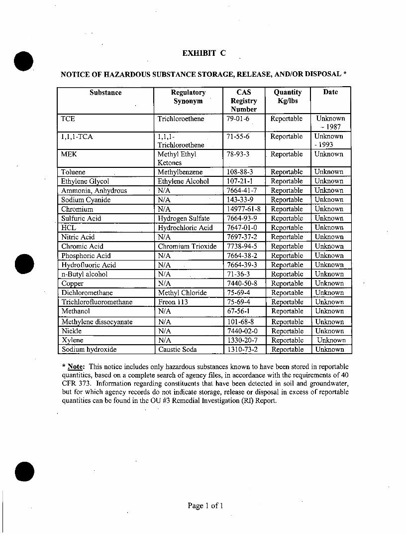
EXHIBIT C
NOTICE OF HAZARDOUS SUBSTANCE STORAGE, RELEASE, AND/OR DISPOSAL *
Substance Regulatory CAS Quantity DateSynonym Registry Kg/lbs
NumberTCE Trichloroethene 79-01-6 Reportable Unknown
-19871,1,1-TCA 1,1,1- 71-55-6 Reportable Unknown
Trichloroethene - 1993MEK Methyl Ethyl 78-93-3 , Reportable Unknown
KetonesToluene Methylbenzene 108-88-3 Reportable UnknownEthylene Glycol Ethylene Alcohol 107-21-1 Reportable UnknownPunrnonia, Anhydrous N/A 7664-41-7 Reportable UnknownSodium Cyanide N/A 143-33-9 Reportable UnknownChromium N/A 14977-61-8 Reportable UnknownSulfuric Acid Hydrogen Sulfate 7664-93-9 Reportable UnknownHCL Hydrochloric Acid 7647-01-0 Reportable UnknownNitric Acid N/A 7697-37-2 Reportable UnknownChromic Acid Chromium Trioxide 7738-94-5 Reportable UnknownPhosphoric Acid N/A 7664-38-2 Reportable UnknownHydrofluoric Acid N/A 7664-39-3 Reportable Unknownn-Butyl alcohol N/A 71-36-3 Reportable UnknownCopper N/A 7440-50-8 Reportable UnknownDichloromethane Methyl Chloride 75-69-4 Reportable UnknownTrichlorofluoromethane Freon 113 75-69-4 Reportable UnknownMethanol N/A 67-56~1 Reportable Unknown
Methylene dissocyanate N/A 101-68-8 Reportable UnknownNickle N/A 7440-02-0 Reportable UnknownXylene N/A 1330-20-7 Reportable UnknownSodium hydroxide Caustic Soda 1310-73-2 Reportable Unknown
* Note: This notice includes only hazardous substances known to have been stored in reportablequantities, based on a complete search of agency files, in accordance with the requirements of 40CFR 373. Information regarding constituents that have been detected in soil and groundwater,but for which agency records do not indicate storage, release or disposal in excess of reportablequantities can be found in the au #3 Remedial Investigation (Rl) Report.
Page 1 of 1
• EXHIBITD
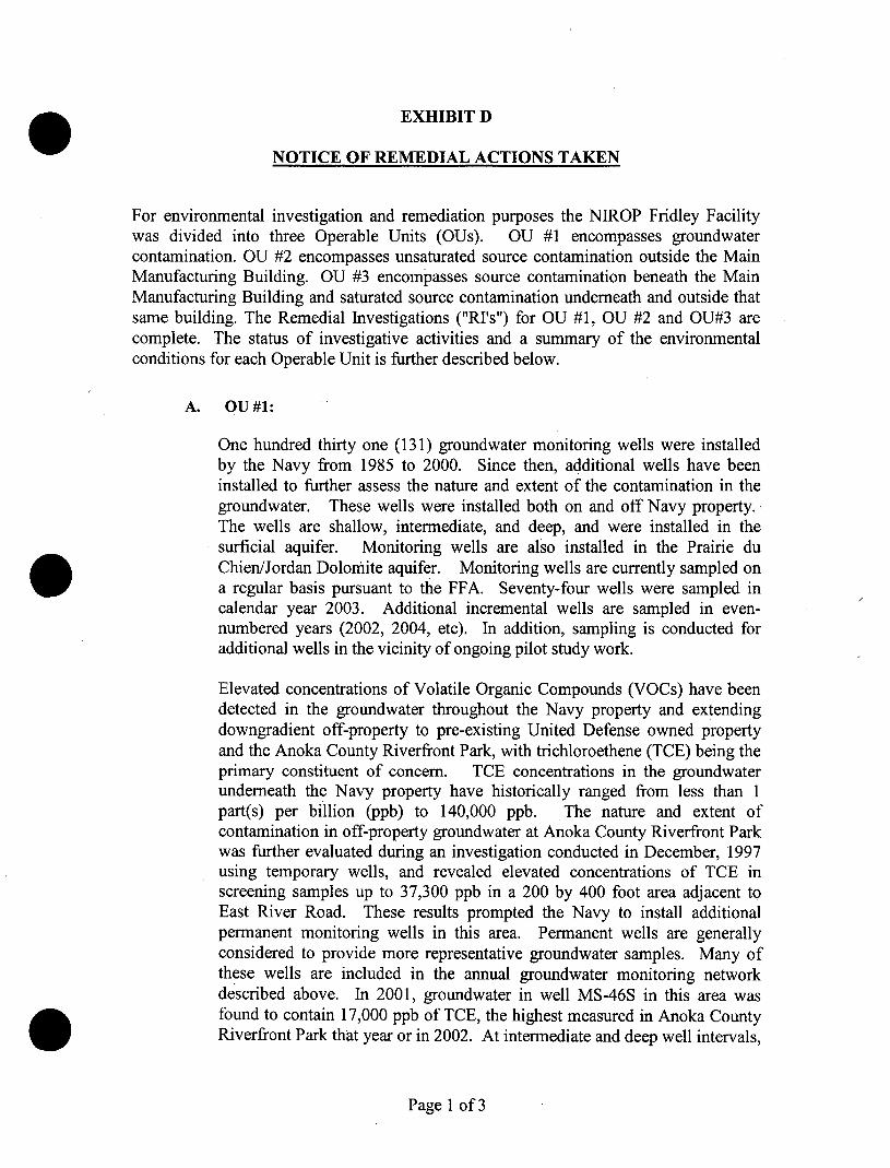
NOTICE OF REMEDIAL ACTIONS TAKEN
For environmental investigation and remediation purposes the NIROP Fridley Facilitywas divided into three Operable Units (OUs). OU #1 encompasses groundwatercontamination. OU #2 encompasses unsaturated source contamination outside the MainManufacturing Building. OU #3 encompasses source contamination beneath the MainManufacturing Building and saturated source contamination underneath and outside thatsame building. The Remedial Investigations ("RI's") for OU #1, OU #2 and OU#3 arecomplete. The status of investigative activities and a summary of the environmentalconditions for each Operable Unit is further described below.
•
•
A. OU#l:
One hundred thirty one (131) groundwater monitoring wells were installedby the Navy from 1985 to 2000. Since then, additional wells have beeninstalled to further assess the nature and extent of the contamination in thegroundwater. These wells were installed both on and off Navy property.'The wells are shallow, intermediate, and deep, and were installed in thesurficial aquifer. Monitoring wells are also installed in the Prairie duChien/Jordan Dolomite aquifer. Monitoring wells are currently sampled ona regular basis pursuant to the FFA. Seventy-four wells were sampled incalendar year 2003. Additional incremental wells are sampled in evennumbered years (2002, 2004, etc). In addition, sampling is conducted foradditional wells in the vicinity of ongoing pilot study work.
Elevated concentrations of Volatile Organic Compounds (VOCs) have beendetected in the groundwater throughout the Navy property and extendingdowngradient off-property to pre-existing United Defense owned propertyand the Anoka County Riverfront Park, with trichloroethene (TCE) being theprimary constituent of concern. TCE concentrations in the groundwaterunderneath the Navy property have historically ranged from less than 1part(s) per billion (Ppb) to 140,000 ppb. The nature and extent ofcontamination in off-property groundwater at Anoka County Riverfront Parkwas further evaluated during an investigation conducted in December, 1997using temporary wells, and revealed elevated concentrations of TCE inscreening samples up to 37,300 ppb in a 200 by 400 foot area adjacent toEast River Road. These results prompted the Navy to install additionalpermanent monitoring wells in this area. Permanent wells are generallyconsidered to provide more representative groundwater samples. Many ofthese wells are included in the annual groundwater monitoring networkdescribed above. In 2001, groundwater in well MS-46S in this area wasfound to contain 17,000 ppb of TCE, the highest measured in Anoka CountyRiverfront Park that year or in 2002. At intermediate and deep well intervals,
Page 1 of3
•
•
•
B.
contaminant concentrations in groundwater are consistently much less. Anongoing pilot study utilizing in-situ bioremediation technology to reducecontaminant levels is in place in the vicinity of this well.
A groundwater extraction, collection and treatment facility was installed tocapture contaminated groundwater migrating offsite. There currently areseven active extraction wells located along the western property boundariesof the NIROP and United Defense. Extracted groundwater from each well isdirected to, and combined in, a building where it is then pumped to agroundwater treatment facility in the northwest quadrant of the MainIndustrial Building. The contaminated groundwater is treated utilizingshaliow tray air strippers to remove the volatile organic compounds with thetreated water discharged to the Mississippi River via the facility's stormsewer under a NPDES permit.
The second CERCLA Five Year Review for OU #1 was completed inOctober 2003, and determined that 'the remedial action for Operable Unit 1continues to be protective of human health and the environment bypreventing further migration of contaminated water off the NIROP facilityand continuing to restore groundwater quality in the unconsolidated aquiferat the site'.
The Five Year Review also discusses the ongoing pilot study, noted above, toaddress contamination remaining downgradient of the NIROP facility (anddowngradient of the groundwater extraction system).
OU#2:
The only portion of OU #2 that remains a potential concern is an area ofunsaturated soils located north of the Main Manufacturing Building known asthe North 40. The North 40 contained former waste disposal pits andtrenches used in the early 1970's. Drums and impacted soils were removedand disposed of during four separate removal actions in 1983, 1991, 1996and 2002. The OU #2 RI evaluated unsaturated soils to a depth of 20 feet.Like OU #1, VOCs, with TCE in particular, are the primary contaminants ofconcern. In general, concentrations ofTCE in the North 40 soils were foundto be in the range of 10 to 69,000 ppb. TCEcontamination in excess of200ppb was found in small, localized areas, with the highest concentrationsfound in shallow subsurface soils (3 - 5 foot depths). In conjunction with the1996 drum removal effort, samples taken at the bottom of the excavation pitswere generally non-detect for TCE except for a single sample with anelevated TCE concentration of 96,000 ppb at an approximate depth of 12feet. The Supplemental Remediation Investigation Information Report datedSeptember 2001 identified potential unacceptable risk levels in sub areas A3and A4. This resulted in an excavation of approximately thirty-five cubicyards of soil in Area A4, in June 2002, and addressed the last known locationwhere there were unacceptable risks in surface soil. Elevated levels of
Page 2 of3
•
•
•
c.
contaminants remain in subsurface soil but do not pose an unacceptable riskprovided institutional controls are in place to prevent future exposure. ARecord of Decision (ROD) specifying these institutional controls was signedby the Navy, US EPA, and MPCA in September 2003. A single RODaddresses both OU #2 and OU #3.
OU#3:
In 1995, an investigation was conducted of the soils and groundwater beneaththe former Plating Shop within the Main Manufacturing Building asidentified in Exhibit 2 (the "Main Building"). This investigation revealedthat soils and shallow groundwater are contaminated primarily with TCE.TCE concentrations from 4 to 100,000 ppb were detected in soil. TCEconcentrations ranging from 1,200 to 140,000 ppb were detected in shallowgroundwater. The highest soil concentrations were found adjacent to aformer wastewater collection sump 'at an approximate depth of 13 feet belowground surface and the highest groundwater concentration 'Was found slightly
, down gradient from the former sump at the top of the surficial groundwatertable, at approximately 16 feet below the former Plating Shop pit floor.
A RI was conducted to assess the condition of soils and groundwater beneaththe Navy owned portion of the Main Building. Field efforts were completedby the end of April 1998. The RI indicates that VOCs (primarily chlorinatedhydrocarbons, aromatics and ketones) were detected in soils. Semi-volatileorganic compounds (SVOC), primarily polyaromatic hydrocarbons (PAH)were also detected in soils ranging from 10 to 5,600 ppb as were metals suchas arsenic, chromium, copper and mercury.' Chlorinated hydrocarbons werethe primary chemicals detected in groundwater samples.
As of December 2003, there have been no soil removal actions or other'active' remedial action taken concerning OU#3, and as of that date none areanticipated. The unsaturated contaminated soils are secured underneath theMain Manufacturing Building floor and do not pose an unacceptable riskprovided institutional controls are in place to prevent future exposure. AROD specifying these institutional controls was signed by the Navy, USEPA, and MPCA in September 2003. A single ROD addresses both OU #2and QU#3.
Page 3 of3

•
•
•
EXHIBITE
Annual LUC Compliance Certification
Property Owner:
Property Address: 4800 East River Road, Minneapolis, MN. 55421
This Certification covers the year 1 January __ through 31 December _(Note: Form must be submitted by 1 March of the year following the reporting period.Should there be a change in ownership during the reporting period, the certificate willonly cover the period of ownership and the new owner will certify compliance for theremaining portion of the reporting period).
Owner Certification
1. The above-named owner certifies that use of the Property has been limited toindustrial or restricted commercial uses, or that owner has provided written notice to theNavy, EPA and MPCA of its desire to use the Property for something other thenindustrial or restricted commercial uses and has obtained approval from the Navy, EPAand MPCA for the release or modification of the Categorical Land Use Restrictionpreviously placed in the owner's deed or chain of title to the property;
2. The above-named owner certifies that no soils deeper than 3 feet below groundsurface have been disturbed in those two Designated Restricted Areas outside the MainIndustrial Building shown in Exhibit 2 to the Government's deed of conveyance withouthaving first obtained written approval from the EPA and MPCA. Owner further certifiesthat no soils excavated from those Areas have been removed from the facility withouthqving first obtained written approval from the EPA and MPCA.
3. The above-named owner certifies that no soils beneath the Designated RestrictedArea known as the concrete pit foundations where metal-finishing operations previouslyoccurred at the former Plating Shop within the Main Industrial Building have beendisturbed without prior written approval from the EPA and MPCA. Owner further certifiesthat no soils excavated from those Areas have been removed from the facility withouthaving first obtained written approval from the EPA and MPCA.
4. The above-named owner certifies that the concrete pit floor (approximately 8 to 12feet below grade floor) where metal finishing operations previously occurred at theformer Plating Shop within the Main Industrial Building has not been removed withoutprior written approval from the EPA and MPCA.
5. The above-named owner certifies that no water supply wells have been installed norgroundwater beneath the property extracted or used for any purpose without prior writtenapprovals having first been obtained from EPA, MPCA and the Minnesota Department ofHealth. This certification shall not apply to the extent the Owner installed monitoringwells at the request of the Navy.
Page 1 of2
• 6. The above-named owner certifies that it has not unreasonably hindered or preventedthe Navy, EPA or MPCA from constructing, upgrading, operating, maintaining andmonitoring any groundwater treatment facilities and groundwater monitoring network orhas otherwise engaged in any activity that: (i) caused the violation of any Health andSafety Plan put into effect by the Navy, EPA or MPCA on the Property and directlyrelated to the Federal Facilities Agreement at the Property; or (ii) disrupted or hinderedany other remedial, response or oversight activities being undertaken by the Navy, EPAor MPCA on the property.
I, the undersigned, hereby certify that I am an authorized representative of the abovenamed property owner and that the above described Land Use Controls have beencomplied with for the period noted. Alternatively, any known deficiencies and owner'scompleted or planned actions to address such deficiencies are described in the attachedExplanation of Deficiency(ies).
•
•
Date
Mail completed forms to:
Director, Environmental Services Business LineSouthern DivisionNaval Facilities Engineering CommandP.O. Box 190010North Charleston, SC 29419-0010
U.S. Environmental Protection AgencyRegion 577 West Jackson Blvd.Chicago, IL 60604
CommissionerMinnesota Pollution Control Agency520 Lafayette Rd. N.St. Paul, MN 55155
Owner's Authorized Representative
Page 2 of2