final state route 37 – segment a sea level rise corridor … · 2019-04-03 · introduction ......
TRANSCRIPT

FINAL State Route 37 – Segment A
Sea Level Rise Corridor Improvement Study
June 18, 2018
Prepared for: Prepared by:

State Route 37 – Segment A Sea Level Rise Corridor Improvement Study
Table of Contents Executive Summary ..................................................................................................................... 1
Introduction ................................................................................................................................ 4
Environmental Conditions .......................................................................................................... 5
Future Changes ......................................................................................................................... 11
Design Criteria and Considerations........................................................................................... 12
Alternatives Study ..................................................................................................................... 13
Structures .................................................................................................................................. 17
Intermodal Considerations ....................................................................................................... 21
Other Corridor Considerations ................................................................................................. 22
Attachments.............................................................................................................................. 25
References ................................................................................................................................ 26

State Route 37 – Segment A Sea Level Rise Corridor Improvement Study
page 1
Executive Summary
Background Prior studies of State Route 37 have provided analysis of the severe congestion and
temporary flooding that this corridor is experiencing. In addition, the forecasted sea
level rise (SLR) and its future impacts on the corridor has been an important part of
the analysis. Prior studies divided the corridor into segments A, B and C extending
across the three counties; Marin, Sonoma and Solano.
In response to the findings from recent studies of the corridor, TAM engaged HNTB to
provide technical assistance and to prepare a study including conceptual plans for
long-term integrated solutions to the anticipated SLR affecting Segment A. As such,
the study concepts would provide for future integration of restoration, as opposed to
preclude them; however, restoration projects are not being evaluated or proposed in
this study. As prior studies stated, the roadway is relatively low-lying, about 2-6 feet
NAVD88 for most of the portion except between Atherton Ave and Petaluma Bridge
and transitions to rolling terrain and upland along the eastern end near the SR 37/SR
121 junction. Portion of the road relies on unengineered levees and berms along
Novato Creek, the Petaluma River and landward levees of the Sonoma Baylands not
originally designed to protect the road but to reclaim lands for agricultural use.
Sea Level Rise The single most important design criteria for this study was to establish a
conservative design elevation for the roadway surface to protect against flooding for
expected SLR in the year 2100.
The roadway elevation was developed based on current understanding of SLR criteria
for year 2100. The roadway elevation is made up of the storm surge return periods,
wave runup, SLR and freeboard. Conservatively, the calculated SLR elevation for
2100 includes the 100-year wave height (3 feet) and a freeboard of 2 feet per
Caltrans guidelines. Wave runup was included in the overall SLR calculation since it is
unknown where the ultimate shoreline will be and where marshland and mudflat will
be between the proposed structure and the Bay.
The calculated minimum roadway elevation is 21.8 feet (NAVD88 Survey Datum) and
is the basis for the alternatives development in this study.
Design Considerations In addition to establishing a SLR elevation, the alternatives design developments
were informed by the historical, present and future conditions within segment A. The
historical Novato Creek baylands were low-elevation areas subject to regular tidal
influence. Over the past 150 years, diking and filling for flood control and land
reclamation purposes have eliminated most of the historical baylands. As such,
during the alternatives analysis, the historical baylands boundary was used to
determine the limits of causeway versus embankment. It is assumed that the

State Route 37 – Segment A Sea Level Rise Corridor Improvement Study
page 2
ultimate condition would restore the marshland and mudflats to the historic
conditions.
The roadway cross section assumed for this study is an expressway type roadway per
the Caltrans Highway Design Manual. In addition, a multiuse path is provided along
the EB direction only. The roadway section consists of:
• Two 12 feet wide lanes in each direction
• Standard shoulder widths – Minimum 5 feet left shoulder and 10 feet right
shoulder
• A 12-foot-wide multi-use path located along the EB direction only
Alternatives Development The following is a description of the conceptual alternatives developed for this the study.
Alternative 1
This option proposes to raise SR 37 on a causeway between US 101 and SR 121. The
limits of improvements were dependent on the existing ground elevation compared
to the calculated roadway elevation needed to meet for SLR. Lakeville Rd and
Reclamation Rd will be elevated on embankment to conform to the proposed
elevated SR 37. Proposed improvements to SR 37 between US101 and Lakeville Rd
will be on causeway. Where the existing roadway is above the calculated SLR
elevation, the design only proposes to widen for the 12 feet multi-use path.
The preliminary planning cost estimate for Alternative 1 is:
• $1.832 Billion - Year 2018 ($842 Million in Marin County and $990 Million in
Sonoma County)
• $2.634 Billion (15 years escalation)
Alternative 2
This option is a hybrid option in which segment A will be a combination of
embankment and causeway structure. The limits of the roadway on embankment
was determined from the historic baylands boundary. It is assumed that the goal is
to restore the surrounding environment back to its historic condition. As such, any of
the current roadway below the projected SLR elevation will be elevated using a
combination of a causeway structure and embankment. Where the existing roadway
is above the projected SLR elevation, the design only proposes to widen for the 12
feet multi-use path.
The preliminary planning cost estimate for Alternative 2 is:
• $1.358 Billion - Year 2018 ($570 Mill in Marin County and $788 Mill in Sonoma
County)
• $1.944 Billion (15 years escalation)
Alternative 3
This option proposes to only raise the roadway between US 101 to just past Novato
Creek to be above the projected SLR elevation. This segment was determined to be

State Route 37 – Segment A Sea Level Rise Corridor Improvement Study
page 3
on a causeway structure as it falls within the historical baylands boundary and
hydraulic connectivity between the north and south sides of SR 37 is easily achieved.
The preliminary planning cost estimate for Alternative 3 is:
• $364 Million - Year 2018 (Marin County only)
• $522 Million (15 years escalation)
US 101/SR 37 Interchange
For each of the three alternatives described above the US 101/SR 37 interchange was
reviewed for SLR impacts but no detailed analysis was completed due to schedule
limitations of this study. However, based on the historical baylands boundary, the
existing US 101/SR 37 interchange will be inundated by water as the existing US 101
roadway elevation is below the projected SLR elevation. To provide an ultimate
solution, the interchange will need to be elevated along with the off- and on-ramps
to raise above the projected SLR. The preliminary costs to upgrade the interchange is
expected to be in the $75 to $120 million range.
Intermodal Considerations
Accommodations for Bike and Pedestrian Users
The proposed cross section allows for a 12-foot-wide multi-use path. This multi-use
path is proposed to connect to the existing Bay Trail currently located between
Railroad Ave and Reclamation Road. Connecting the Bay trail will follow the guidance
provided in the recent Caltrans’ Transportation Concept Report for SR 37.
Accommodation for Transit
Currently there are no bus transit routes along SR 37. There is potential for
implementing bus transit routes with dedicated bus stops and park and ride facilities
along the highway.
Consideration for express busses using the roadway shoulder as dedicated bus lanes
could also be an option. As SMART has started its revenue service, busses could link
up to a SMART train stations in Novato as an option for travelers wanting to go north
or south.

State Route 37 – Segment A Sea Level Rise Corridor Improvement Study
page 4
Introduction
Prior studies of the SR 37 have provided analysis of the severe congestion and
temporary flooding that this corridor is experiencing. In addition, the forecasted sea
level rise (SLR) and its future impacts on the corridor has been an important part of
the analysis. Prior studies divided the corridor into segments A, B and C extending
across the three counties; Marin, Sonoma and Solano.
In response to the findings in a recent study by MTC, the “SR 37 Transportation and
Sea Level Rise Corridor Improvement Plan” dated September 2017, TAM requested
HNTB’s technical assistance in preparing conceptual alternatives for long-term
integrated solutions, that address both highway vulnerabilities and facilitate the
restoration of surrounding Baylands, in conjunction with the anticipated sea level rise
affecting Segment A. However, no restoration projects are being evaluated or
proposed as part of this study.
Segment A extends from US 101 in Marin County for 3.4 miles and continues for 3.9
miles in Sonoma County to the SR 121 junction. The segment is designated a 4-lane
expressway with bridges over Novato Creek, Simmons Slough Creek, Petaluma River,
Atherton Ave, an inter-change at Highway 101 and Atherton Ave and an at-grade
intersection at Lakeville Road and SR 121. There are three minor access
roads/driveways connecting to SR 37 along the westbound lanes near Novato Creek
towards Simmons Slough. Suggested realignments of these access roads have been
depicted on the engineering plans. The Sonoma-Marin Area Rail Transit (SMART) is
also located south of SR 37 and runs parallel between US 101 and Atherton Ave.
The roadway is relatively low-lying, about 2-6 feet NAVD88 for most of the portion
except between Atherton Ave and Petaluma Bridge and transitions to rolling terrain
and upland along the eastern end near the SR 37/SR 121 junction. Portion of the
road relies on unengineered levees and berms along Novato Creek, the Petaluma
River and landward levees of the Sonoma Baylands not originally designed to protect
the road but to reclaim lands for agricultural use.
This study focused on developing three highway raising alternatives as listed below
and described in more detail in the Alternative Analysis section of this report:
1. An all bridge/causeway alternative between US 101 to SR 121
2. A hybrid option (bridge/causeway and embankment) between US 101 to SR
121
3. A causeway between US 101 to Novato Creek only
These alternatives being reviewed would provide for a future integration of
restoration, as opposed to preclude them. However, restoration projects are not
being evaluated or proposed in this technical evaluation.
Prior to developing alternatives, the design team met with key stakeholders, land
owners and interest groups along the corridor to understand the current and future
for restorations, land

State Route 37 – Segment A Sea Level Rise Corridor Improvement Study
page 5
uses and the environmental conditions. Attachment A provides a summary map of
findings from these discussions.
Environmental Conditions
The single most important design criteria for this study was to establish a
conservative design elevation for the roadway surface to protect against flooding for
expected SLR in the year 2100. The following text describes in more detail how the
design elevation was established.
Tides The Bay has mixed semi-diurnal tides, meaning that there are two unequal high tides
and two unequal low tides during each day. The average elevation of the highest
daily tide is called Mean Higher High Water (MHHW); the average elevation of the
lowest low water is called Mean Lower Low Water (MLLW). The difference between
MHHW and MLLW is the tide range. The tides are caused by the gravitational pull of
the moon and the sun and are very predictable. The highest astronomical tides are
called Perigean Spring Tides that occur a few times per year. These very high tides are
an early indication of what future typical tides may inundate with sea level rise on a
daily basis.
Storm Surges In addition to the regular astronomical tides, the Bay experiences El Niño, storm
surge and waves, and depending on location, freshwater discharge from rivers during
storm events. Alone, or in combination, these factors result in temporary higher
water levels, referred to as extreme water levels. Storm surges in the Bay are limited
to about 3.5 feet above normal tide levels. Extreme water levels are usually
characterized in terms of probability: a 1-percent-annual-chance tide (or 100-year
extreme water level) is the water level elevation in the Bay that has a 1% chance of
being reached (or exceeded) in any given year. Waves are similarly characterized by
probability.
For Petaluma River and Novato Creek the tidal datums and 100-year extreme water
level have been calculated by FEMA as part of their recent remapping of the Bay
(AECOM 2016):
Elevation ft. NAVD88
100-year extreme water level 9.9
Mean Higher High Water (MHHW) 6.3
Mean Sea Level (MSL) 3.4
Mean Lower Low Water (MLLW) 0.1
Table 1: Present (2000) tidal datum and extreme water surface elevations for Petaluma
River and Novato Creek.

State Route 37 – Segment A Sea Level Rise Corridor Improvement Study
page 6
Waves While the Bay is sheltered from oceanic waves, local winds blowing over relatively
long fetches do generate waves in San Pablo Bay. Waves cause both flooding due to
runup and overtopping, and also the erosion of levees. The wave height at a structure
depends on its location on the shoreline and how much marsh and mudflat is (or
expected to be) between the structure and the Bay. For Petaluma River and Novato
Creek, the 100-year wave height is about 3 ft. (AECOM 2016). Wave runup depends
on the elevation, slope, porosity, and roughness of the structure as well as the wave
conditions. For a 3-ft. wave at the Petaluma River or Novato Creek, wave runup might
reach 13ft NAVD88 or more depending on the structure and its location relative to
the shoreline.
Sea Level Rise Sea level rise will increase the elevation of mean water level and there will be a
commensurate increase in the elevation of extreme water levels. Sea-level rise
guidance for California has recently been drafted, following updates in projections,
but these have yet to be adopted by Caltrans (CNRA-OPC 2017). The draft guidance
provides probabilistic decadal projections of sea-level rise, with respect to a baseline
of the year 2000, based on high and low emission scenarios, and location on the
California coast. The recommended projections for San Francisco are shown in the
red boxes in Table 2 below.

State Route 37 – Segment A Sea Level Rise Corridor Improvement Study
page 7
Table 2: Projected Sea-Level Rise (in feet) for San Francisco (Table 1, p18, CNRA-OPC 2017).
The red boxes show the projections recommend for use by CNRA-OPC (2017) in low,
medium-high and extreme risk aversion decisions.

State Route 37 – Segment A Sea Level Rise Corridor Improvement Study
page 8
Assuming medium to high-risk aversion, the projected sea level rise in San Francisco
Bay, between the year 2000 and 2100, is 5.7 to 6.9 feet shown in blue box in Table 2.
Assuming a high emission scenario, the minimum roadway elevation is projected to
be as shown in Table 3.
Minimum Roadway Elevation based on 2100 SLR Projection Novato Petaluma
NAVD (ft.) NAVD (ft.)
Mean Lower Low Water (MLLW) 0.1 0.1
+ Mean Sea Level (MSL) 3.4 3.4
+ Mean High Water (MHHW) 6.2 6.3
+ 1:100-year storm surge of 3.6 ft. 9.8 9.9
+ SLR of 6.9 ft. 16.7 16.8
+ Waves of 3 ft. 19.7 19.8
+ Freeboard (assume 2 feet) 2 2
Projected Minimum Roadway Elevation 21.7 21.8
Table 3: Minimum Roadway Elevation - Future (2100) tidal datum and extreme water
surface elevations for Petaluma River and Novato Creek.
Historical and Present Landscape of Novato Creek The alternatives design criteria were also informed by the historical and present
landscapes along SR 37. The historical Novato Creek baylands were low-elevation
areas subject to regular tidal influence (Figure 1).
Over the past 150 years, diking and filling for flood control and land reclamation
purposes have eliminated most of the historical baylands. Levee construction along
lower Novato Creek and the rerouting of Arroyo San Jose and Pacheco Creek (which
entered the baylands from the south) began in the late 19th century and was
completed by the early 1920s (SFEI 2015). The result has been the confining of fluvial
and tidal flows, which resulted in sediment accumulation within mainstem Novato
Creek, the elimination of the historical tidal channel network that connected lower
Novato Creek to its surrounding baylands, and the elimination of the sediment supply
that helped maintain and sustain the elevation of the baylands.
SR 37 runs northeast-southwest through the middle of the former well-drained tidal
marsh of area A. The road bisects numerous small historical channels and both
Novato Creek and Simmons Slough. The former marshes have subsided by several
feet below MHHW, and the whole area is dependent upon levees and pumping to
prevent flooding. If the levees did fail then large parts of Area A would be inundated
on each tide. The Novato Sanitary District operates a series of wastewater treatment
ponds to the north, and sprayfields to the south of SR 37.

State Route 37 – Segment A Sea Level Rise Corridor Improvement Study
page 9
Figure 1: Map of Novato Creek showing historical wetland habitat types and the present
alignment of SR 37.
Historical and Present Landscape of Petaluma River Historically, tidal wetlands occupied about 16,000 acres along the lower Petaluma
River (Figure 2). The tidal wetlands were composed of a range of estuarine habitat
types including tidal marsh, intertidal flats, subtidal channels, and marsh
ponds/pannes (SFEI 2018). The Petaluma River entered the estuary near present-day
Payran Street in Petaluma, and followed a sinuous course for 17 miles to its mouth at
San Pablo Bay, influenced both by tidal flux and by freshwater input from the
Petaluma River, San Antonio Creek, and other tributaries.

State Route 37 – Segment A Sea Level Rise Corridor Improvement Study
page 10
Figure 2: Map of Petaluma River showing historical wetland habitat types and the present
alignment of SR 37.
Beginning in the late 19th century, thousands of acres of tidal marsh were diked and
drained to reclaim lands for agricultural use. The extent of tidal wetland has
decreased by about 70% (SFEI 2018). Despite this substantial loss of tidal wetland
habitats, the Petaluma Marsh remains the largest contiguous expanse of historical
tidal marsh in San Pablo Bay. Restoration efforts in recent decades have begun to
reverse the decline in tidal wetland extent.
SR 37 runs northeast-southwest from Black Point northeastward the middle of the
former well-drained tidal marsh of area E. The road bisects a large number of small
historical channels although the main drainage is parallel to SR 37 towards the
Petaluma River. The diking and draining along the East Bank to the north of SR 37
reclaimed low marsh, mudflat and shallow subtidal areas of False Bay (SFEI 2018).
The land elevations were low in this area before any subsidence and so is now many
feet below MHHW, and the whole area is dependent upon levees and pumping to
prevent flooding. If the levees fail, large parts of Area F and E would be inundated on
each tide. The levees on the eastern bank of the Petaluma River are in particularly
poor shape.

State Route 37 – Segment A Sea Level Rise Corridor Improvement Study
page 11
Future Changes
With significant sea level rise projected in San Francisco Bay by 2100 under existing
emissions trajectories (CNRA-OPC 2017), existing wetlands in the Petaluma Marsh are
at risk and land uses in low-lying surrounding areas are jeopardized. Levee
overtopping will likely become more frequent in diked, subsided baylands, while the
increased frequency of inundation may accelerate bank erosion and habitat
conversion in tidal wetlands (Goals Project 2015). Climate change will also alter
streamflow patterns and vegetation distribution throughout the watershed;
countywide, climate change is projected to increase the severity of flood events, the
frequency and severity of droughts, and the frequency of extreme heat events.
Of particular concern, is the potential increase in flow rates along the tidal channels
of Petaluma River and Novato Creek as tidal action is restored to diked areas, either
by design through restoration projects or by accident due to erosion and breaching of
levees. The presently diked baylands are very large areas of subsided land which,
since they lie within the tidal range, will fill and empty on each tide if their levees are
breached. The volume of water that enters the marshes and any subsided land on the
flood and leaves on the ebb is called the tidal prism. The tidal prism is conveyed to
and from the marsh by the tidal channels. The present tidal prism is relatively small,
since most areas are protected by levees, and so many of the channels have been
filling in. If the tidal prism increases due to breaching then these channels will erode
to a size that allows them to convey the increased volume of water. Erosion of the
channels to convey water may result in erosion of levees and scouring around bridge
piles. It is therefore essential to estimate the future widths of the main channels that
SR 37 crosses to ensure that the bridges spanning them are long enough to avoid
scouring.
The relationship between channel size at a particular cross-section of a tidal channel
and the tidal prism upstream of that cross-section is known as hydraulic geometry
and has been investigated by Williams et al (2002) for marshes in San Francisco Bay.
The future width of Petaluma River, Novato Creek and Simmons Slough were
calculated using hydraulic geometry assuming all the diked baylands upstream of the
crossings would be restored, either deliberately or accidently, to tidal action. These
dimensions were incorporated in the design described in the next section “Design
Criteria and Considerations”.

State Route 37 – Segment A Sea Level Rise Corridor Improvement Study
page 12
Design Criteria and Considerations
Based on the historical, present and future conditions within segment A design
criteria were developed.
Roadway Cross Section
The historical Baylands Boundary was used to determine the limits of causeway
versus embankment. It is assumed that the ultimate condition would restore the
marshland and mudflats to the historic conditions as shown in Attachment A.
The roadway cross section assumed for this study is an expressway type per the
Caltrans Highway Design Manual. In addition, a multiuse path is provided along the
EB direction only. The roadway section consists of:
• Two 12 feet wide lanes in each direction
• Standard shoulder widths - 5 feet left shoulder and 10 feet right shoulder
• A 12-foot-wide multi-use path located along the EB direction only
It should be noted that the roadway section is consistent with the UC Davis Study
that was coordinated with Caltrans in 2015.
Pavement Section The roadway pavement section (on embankment) will consist of 8 inches of asphalt
concrete (AC) and 20 inches of compacted aggregate base (AB) for a traffic index (TI)
equal to 12 for a 20-year pavement design. This pavement section was assumed
based on previous work done by Ducks Unlimited in coordination with Caltrans
during Segment B deceleration lane construction.
For proposed access roads and frontage roads, it was assumed to match the
pavement section to the existing SR 37 condition. The pavement section will be 0.5
feet HMA (hot mix asphalt) and 0.75 feet AB. This pavement section is based on the
AECOM/UC Davis study.
Roadway Elevation The roadway elevation was developed based on current understanding of sea level
rise criteria for year 2100 as described previously. The roadway elevation is made up
of the storm surge return periods, wave runup, sea level rise and freeboard.
Conservatively, the calculated sea level rise elevation for 2100 includes the 100-year
wave height (3 feet) and a freeboard of 2 feet per Caltrans guidelines. Wave runup
was included in the overall sea level rise calculation since it is unknown where the
ultimate shoreline will be and where marshland and mudflat will be between the
proposed structure and the Bay.
The calculated minimum roadway elevation is 21.8 feet as previously depicted in
Table 3.

State Route 37 – Segment A Sea Level Rise Corridor Improvement Study
page 13
Other Design Considerations At the onset of the study, TAM and the project team met with local stakeholders to
discuss and to obtain relevant information the study. The local stakeholder group
included Marin County Department of Water, Sonoma County Transportation
Authority, Caltrans, SMART and the City of Novato Public Works.
Information was also gathered from stakeholders, landowners and interest groups
during an information gathering meeting hosted by the design team. The meeting
was attended by:
• Sonoma Land Trust
• Ducks Unlimited
• Marin County Flood Control and Water Conservation District
• Caltrans
• Marin Audubon Society
• UC Davis
• US Fish & Wildlife Services
Refer to Attachment A for notes gathered from the meeting.
In addition, the design team coordinated with Marin County Flood Control and Water
Conservation District on a study (“California Highway 37 Bridge Configuration at
Novato Creek for Future Sea Level Rise”) for the Novato Creek Bridge improvements
related to sea level rise. This study was utilized for the design of Alternative 2 and 3.
Alternatives Study
For each of the three alternatives described below the US 101/SR 37 interchange was
reviewed for SLR impacts but no detailed analysis was completed due to schedule
limitations of this study. However, based on the historical Baylands boundary outline
(shown in Attachment E), the existing US 101/SR 37 interchange will be inundated by
water as the existing US 101 roadway elevation is below the projected sea level rise
elevation (calculated to be 21.8’). To provide an ultimate solution, the interchange
will need to be elevated along with the off- and on-ramps to raise above the
projected sea level rise.

State Route 37 – Segment A Sea Level Rise Corridor Improvement Study
page 14
Alternative 1- Elevated Structure Design form US 101 to Sears Point
Figure 4 illustrates the location of causeway/bridge structure proposed in Alternative
1 along SR37 between US 101 and SR 121.
Figure 4 – Alternative 1
This option proposes to raise SR 37 on a causeway between US 101 and SR 121. The
limits of improvements were dependent on the existing ground elevation compared
to the calculated roadway elevation needed to meet for sea level rise. Lakeville Rd
and Reclamation Rd will be elevated on embankment to conform to the proposed
elevated SR 37. Proposed improvements to SR 37 between US101 and Lakeville Rd
will be on causeway. See figure 4 below for illustration of elevated causeway
structure and restored marshland.
Where the existing roadway is above the calculated sea level rise elevation, the
design only proposes to widen for the 12 feet multi-use path. See Attachment B for
Alternative 1.
Figure 5 – SR 37 – Elevated Causeway and Restored Marshland

State Route 37 – Segment A Sea Level Rise Corridor Improvement Study
page 15
Alternative 2: Hybrid Design from US 101 to Sears Point
Figure 6 illustrates the locations of causeway/bridge structures and embankment
sections proposed in Alternative 2 along SR37 between US 101 and SR 121.
Figure 6 – Alternative 2
This option is a hybrid option in which segment A will be a combination of
embankment and causeway structure. The section of roadway between US 101 and
Atherton Ave is on a causeway at Novato Creek and Simmons Slough and
embankment everywhere else. The bridge length for the Novato Creek Bridge and
Simmons Slough is based on the historic tidal prism and consideration for marshland
land which will act as a wildlife corridor for the future marshes. The section of
roadway from the Petaluma River to Lakeville road will be on a combination of bridge
and causeway. The roadway section east of Lakeville Rd will be on embankment.
Lakeville Rd and Reclamation Rd will also be elevated to conform to the proposed
elevated SR 37. See figure 7 below for illustration.
Where the existing roadway is above the projected sea level rise elevation the design
only proposes to widen for the 12 feet multi-use path. See Attachment C for
Alternative 2.
State Route 37 – Segment A Sea Level Rise Corridor Improvement Study
page 16
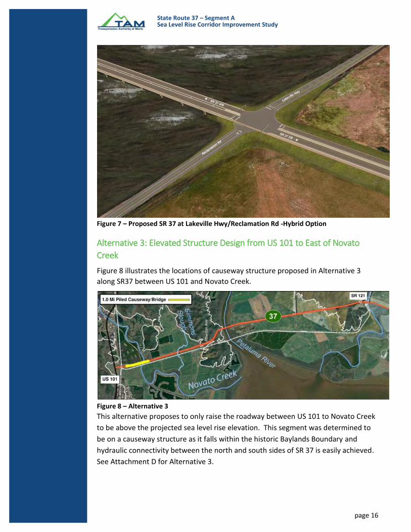
Figure 7 – Proposed SR 37 at Lakeville Hwy/Reclamation Rd -Hybrid Option
Alternative 3: Elevated Structure Design from US 101 to East of Novato
Creek
Figure 8 illustrates the locations of causeway structure proposed in Alternative 3
along SR37 between US 101 and Novato Creek.
Figure 8 – Alternative 3
This alternative proposes to only raise the roadway between US 101 to Novato Creek
to be above the projected sea level rise elevation. This segment was determined to
be on a causeway structure as it falls within the historic Baylands Boundary and
hydraulic connectivity between the north and south sides of SR 37 is easily achieved.
See Attachment D for Alternative 3.

State Route 37 – Segment A Sea Level Rise Corridor Improvement Study
page 17
Local Circulation Consideration Common to all Alternatives Local roadway access currently connecting to SR 37 will either be raised to conform
to the proposed SR 37 or a new frontage road will be provided for circulation.
• Hanna Ranch Road and Marsh Drive will be improved to conform to the
elevated SR 37. These roadways are currently at low elevations and are at risk
to be inundated by sea level rise. It is assumed that these roadways will not
be needed in a marshland environment.
• Renaissance Rd/Atherton Ave will remain an underpass. The on- and off-
ramps from Atherton Ave to SR 37 will need to be improved to conform to the
elevated SR 37. Atherton Ave’s current elevation is also below projected sea
level rise. The study did not evaluate the impacts associated to raising
Atherton Ave.
• Railroad Ave will not be improved. A frontage road will be proposed from
Lakeville Rd and Reclamation Rd to connect to Railroad Ave to provide
adjacent property owners access. The proposed frontage road will also
provide connectivity for the multi-use path to connect existing Bay Trail. This
solution would provide a safer access point for local landowners compare to
the existing condition. Railroad Ave’s current elevation is also below
projected sea level rise. It is assumed that this roadway will not be needed in
a marshland environment.
Structures
For the three build alternatives considered as part of the study, the total elevated
structure or causeway lengths for each alternative are:
• Alternative 1: 5.7 miles
• Alternative 2: 3.0 miles
• Alternative 3: 1.0 miles
To develop a recommendation for the most ideal structure and type along SR 37,
these criteria were considered:
• Terrain, underlaying soils
• Construction Methods
• Total Cost
Construction schedule, construction staging, detailed construction steps, optimized
span arrangement, context and aesthetics of structure types were not evaluated in
detail and are not discussed here.
Superstructure Considerations The constraints explained in previous sections highlight the need for building a
structure type that will attempt to minimize impact to the surrounding soil, consider

State Route 37 – Segment A Sea Level Rise Corridor Improvement Study
page 18
the context where the bridge is being built recognizing the visual impacts and the
possibilities that a continuous viaduct will have on the existing landscape. These
constraints also informed and served as input to develop the order of magnitude of
initial construction costs. Construction costs were evaluated under these general
assumptions:
• The bridge soffit (bottom of bridge) is 2 feet over the maximum expected sea
level rise elevation
• For the typical causeway bridge, the bridge spans (spacing between bents,
columns, or piles) range from 80-150 ft.
• The existing Petaluma River bridge is replaced with either a long span
balanced cantilever structure or a cable supported structure. Detailed type
selection is not part of this report.
• Complete Replacement of the Petaluma River Bridge represents the highest
dollar value and future investment anticipated. Per the available bridge plans,
the Petaluma Bridge was constructed in 1956. This means that this bridge will
exceed its design life by the year 2031. The “design life” is the target life in
years set at the initial design of the bridge. This is typically 75 years. This
does not mean that the bridge isn’t usable. It is conceivable that with
continuous inspections and potentially increased regular maintenance and
rehabilitation of bridge elements, the bridge can still be in service beyond its
“design life.” Some examples are the Golden Gate Bridge, Brooklyn Bridge,
etc. However, recommending a full replacement addresses these items:
o No significant upgrades to the existing concrete bridge deck are noted.
It is probable that deck replacement will be required in the future.
o The bridge width does not meet current shoulder & emergency lane
standards.
o The bridge approach grades (slopes) exceed the max allowed ADA
requirements for comfortable usage by pedestrians and cyclists. The
installation of a dedicated multi use bike/pedestrian will require a
separate, lower profile structure constructed with a lower profile that
will potentially interfere with the current vertical navigational channel.
o If it is desired to span/clear the future widened channel due to SLR and
supports for the bridge within the channel are precluded from being
installed, then replacement of the existing bridge should be
considered.
• The total cost for all alternatives is based on a dollar per square foot cost
($/ft2).
• Two types of superstructure or bridge types are considered. “Conventional”
or “routine” structures, and “unconventional” types. These labels generally
refer to the most common methods of construction typically employed in
California. However, investigation of the application of “unconventional
types” is recommended since there are significant advantages such as quality,

State Route 37 – Segment A Sea Level Rise Corridor Improvement Study
page 19
life-span, construction duration, etc. that should be considered in future
studies. see table 5 below.
STRUCTURAL SECTION
COMMON SPAN RANGE (ft.)
REMARKS
CONVENTIONAL
CIP/PS Box girders (Cast-in-Place prestressed concrete girder)
110-350
This bridge type accounts for approximately 65% of all bridges built on CA state highways.
PC/PS I girders – (Precast Prestressed concrete girder)
95-150 (Bulb girder) 80-180 (Wide flange)
No Falsework Required (temporary scaffolding)
PC/PS I girders – ABC - (Precast Prestressed concrete girder – ABC – Accelerated Bridge Construction
50-120
No falsework required (temporary scaffolding). Rapid construction No subsequent deck installation.
Steel Plate Girder
60-300 No Falsework required (temporary scaffolding)
UNCONVENTIONAL
Segmental Box girders
CIP Cantilever – 300 to 800
CIP Incremental Launch -200-500
PC Cantilever– up to 350ft
PC Span by Span 120 -150
No falsework required Rapid construction Requires large staging area for pre-casting yard
Cable Stayed Bridge 450 – 1500 Long span structure
Table 5 – Structure Types
Substructure Considerations The soft clayey conditions of the existing soil underlying the proposed causeway
alignment guide the type of bridge supporting foundations. Considerations for
construction access, over water construction, soft compressible soils, and minimizing
disturbance to surroundings are generally considered.
Based on general reviews of the site soils, steel pipe piles, large diameter pipe piles
appear to be most appropriate foundation type at this site. The number of piles per

State Route 37 – Segment A Sea Level Rise Corridor Improvement Study
page 20
bent is not explicitly captured within the total cost but it is worth noting that this
factor will influence the total structures cost.
Issues to consider during the foundation type selection (not evaluated as part of this
study) are:
• Site seismicity
• Total Vertical and lateral loads, which are dependent on span length
• Installation Method which considers noise and speed on installation.
• Desired Longevity
• Site Specific Corrosion Concerns
There are additional items that need to be considered and that will influence the cost
and final bridge type selection. These are bridge maintenance and aesthetics and
they are briefly discussed below.
Maintenance Considerations An additional topic that must be discussed and considered in the future is the
maintenance of the new infrastructure. These items need to be considered during
type selection report as they may also influence the type and cost of the proposed
structure. The following are typical intervals of anticipated maintenance for a typical
bridge:
1. Cast in place deck slab (35 and 70 years)
2. Deck wearing surface (30, 60 and 90 years)
3. Painting of steel (75 years with biennial inspection)
4. Elastomeric bearings (40 and 80 years)
5. Expansion joints (25, 50, and 75 years)
6. Drainage System (60 years)
7. Cables (for cable supported structures) – 75 years
Bridge Aesthetic Considerations The public is becoming more aware of the effects that the appearance of large
structures and bridges have in their communities. Bridges function not only as a
transportation element. In the right context bridges can act as visual and symbolic
elements of their communities. With that in mind, the bridge type and its final shape
needs to be considered during the preliminary and final evaluation of structure types.
During these studies, the shapes and sizes of the structural elements are considered
to develop an “aesthetically pleasing” structure. Although this is a very subjective
topic, simple criteria such as simplicity of forms, good proportions emphasizing
thinness, a clear visual demonstration of how the structure behaves, and how the
structure fits its context and surroundings can result in a successful bridge for the
site.

State Route 37 – Segment A Sea Level Rise Corridor Improvement Study
page 21
Cost Estimates Costs do not include removal of old bridge or existing bridge modifications.
Additional assumptions for construction costs are:
1. Bridges will be designed for a 100-year life.
2. Estimates are limited to structural cost only.
3. Costs/SQFT are based on averaging out high end and low-end costs per sq. ft.
4. Estimates are based on 2018 dollars.
For cost estimates and summaries see attachments B, C, D.
Cost Comparison of Recent Studies in the Corridor In October of 2015 the “State Route 37 Integrated Traffic, Infrastructure and Sea
Level Rise Analysis” (UC Davis/AECOM) was published proposing structure/causeway
alternatives and a levee/embankment alternative. Costs for these alternatives were
estimated using the Caltrans 11-page cost estimate template. Kimley Horn recently
completed the “SR 37 Transportation and Sea Level Rise Corridor Improvement Plan”
February 2018, analyzing similar alternatives. However, limited cost data was
available for comparison purposes (a Caltrans cost estimate template was not
published as part of the report). Attachment G provides a summary of previous
alternatives in comparison with alternatives developed as part of this study report.
A cost comparison table (Attachment H) of the UC Davis/AECOM structure/causeway
alternative and Alternative 1 - structure/causeway in this study report was developed
to evaluate the cost differences between these two similar alternatives. The
comparison was based on the Caltrans 11-page cost estimate template developed for
both alternatives. Key differences included:
• TAM/HNTB alternative includes more square foot of bridge construction.
• TAM/HNTB bridge cost (SF) is in the medium to high range per Caltrans cost
data.
• AECOM/UC Davis bridge cost (SF) is at the low-end range per Caltrans cost
data.
• Mobilization and Contingency costs are different, higher for the TAM/HNTB
alternative.
• 101 Ramp re-construction included in the TAM/HNTB alternative, no
improvements shown in the AECOM/UC Davis Study.
• Petaluma Bridge is included as full replacement in the TAM/HNTB alternative,
UC Davis/AECOM alternative includes widening only.
Intermodal Considerations
Accommodations for Bike and Pedestrian Users The proposed cross section allows for a 12-foot-wide multi-use path. This multi-use
path is proposed to connect to the existing Bay Trail currently located between

State Route 37 – Segment A Sea Level Rise Corridor Improvement Study
page 22
Railroad Ave and Reclamation Road. A frontage road is proposed between Railroad
Ave and Reclamation Rd with access from Reclamation Rd to connect to the multi-use
path proposed by the study to the existing Bay Trail. Connecting the Bay trail will
follow the guidance provided in the recent Caltrans’ Transportation Concept Report
for SR 37.
Accommodation for Transit Currently a bus transit routes along SR 37 does not exist. There is potential for
implementing bus transit routes with dedicated bus stops and park and ride facilities
along the highway. Natural locations for park and ride facilities would be Sears Point
junction (SR 37/SR 121) and at Atherton Rd/SR 37 (park and ride currently exist at this
location).
Consideration for express busses using the roadway shoulder as dedicated bus lanes
could be an option. A consideration for bus transit could be to have a transfer point
at a SMART train station in Novato for riders wanting to go north or south.
Other Corridor Considerations
In addition to the proposed design, the design team considered the following issues
that would need to be addressed as part of an overall solution for the corridor.
Geotechnical Consideration Geotechnical investigations were not performed for this study. Geotechnical
information was supplement by the Geotechnical Report provided by Ducks
Unlimited for work completed in Segment B.
Based on review of this report, it is assumed that the corridor “is underlain by soft to
stiff clays and silts that have relatively low strength and are highly compressible.”
The project is also within a “seismically active region”.
The design assumes that the embankment section will be filled with dirt. The
calculated earthwork quantity is approximately 1.1 million cubic yards of dirt. This is
an enormous amount of dirt to import to the project site and as such, would need to
be investigated in detail during the environmental documentation phase. For
example, to offset the dirt quantity, alternative materials to investigate are cellular
concrete and geofoam. These materials were not quantified or studied for
applicability for this project.
Staging The study has not evaluated any staging concepts for each of the alternatives.
Although alternatives are currently following the existing alignment of SR 37 there
are opportunities for adjustments to the north where the ROW is more generous. The
natural sequencing would be to shift traffic to one side of SR 37 while constructing
the other side including temporary detours that provide connections to intersecting

State Route 37 – Segment A Sea Level Rise Corridor Improvement Study
page 23
roads. Any staging concepts must assume that 2 lanes in each direction be kept
operational during construction.
Elevating Sonoma-Marin Area Rail Transit (SMART) Rail The existing SMART rail line located just south of SR 37 is currently below the
projected sea level rise for 2100. If a project is funded to elevate SR 37, but does not
include accommodation for the SMART rail alignment, the rail will be inundated in
the future and compromise the railroad line.
Additional coordination with SMART would be required to determine the usage of
the existing rail line in the future.
Improving Sears Point Levee The existing Sears Point levee located south of SR 37 between Lakeville Rd and SR 121
was recently constructed by Ducks Unlimited. This levee was designed to sea level
rise criteria available at the time (2014). The levee was overbuilt with additional
backslope such that it can go up by 7 feet in elevation if necessary to accommodate
future sea level rise. Such improvement could eliminate the need for elevating the
segment of SR 37 east of Lakeville Rd. SR 37 would be proposed to be elevated just
past Lakeville Rd and descend quicker to conform to the existing roadway. Lakeville
Rd and Reclamation Rd will still need to be elevated to meet the projected SLR. The
cost of raising the existing Sears Point levee was not consider as part of this study.
Realigning Lakeville Road In lieu of raising Lakeville Rd to connect to the proposed SLR elevation of SR 37, an
alternative would be to realign Lakeville Rd to follow along the historic Baylands
Boundary and thereby stay outside the area affected by SLR. It is unknown what kind
of environmental or right of way impacts there would be. This study did not analyze
this.
Raising Atherton Ave Based on the historic Baylands Boundary, existing Atherton Ave will be inundated
with water in year 2100. To mitigate this, it is recommended to further investigate
options such as raising Atherton Ave to create an interchange at this location or
realigning Atherton Ave to the east to be located outside of the historic Baylands
Boundary shown in Attachment E. This study did not evaluate Atherton Ave beyond
what is included in the alternative analysis.
US 101 Based on Historic Baylands Boundary, 2.5 miles of the existing US 101 mainline will be
inundated with water in year 2100. This section of roadway below sea level rise is
along US 101 between De Long Ave to the US 101 SB on-ramp from Novato Blvd. To
mitigate this, it is recommended to further investigate options such as raising the
section of US 101 mainline that is below sea level rise or construct a levee to protect

State Route 37 – Segment A Sea Level Rise Corridor Improvement Study
page 24
the freeway. Elevating the US 101 mainline will also require reconstruction of the
existing overpass connecting to SR 37.
To reconstruct the interchange to protect for future SLR, the cost is expected to be in
the $75 to $120 million range.
Right of Way Right of way was roughly evaluated for this study based on the engineering needs
required to construct the proposed roadway. Additional evaluation and right of way
analysis would be required to determine overall impacts to the surrounding
properties. In addition, access rights to existing properties along SR 37 will be
impacted by the design and will require future discussions.
Conclusion Along the SR 37 corridor Segment A is lower in elevation compared with segments B
and C. If no measures are taken to protect Segment A from SLR, the roadway will be
inundated and closed to traffic in the future. This will effectively break the
connectivity between Marin and Sonoma County and connectivity to eastbound I-
80/Sacramento/Tahoe and force drivers to use alternative routes already congested
during peak commute times or deficient to handle additional capacity.
A holistic approach to solve congestion, SLR and ecological consideration is
recommended for the entire corridor to provide a solution that will serve all users
and stakeholders equally; however, locations such as Port Sonoma and Novato creek
is already under threat today during 5-year and 25-year storms requiring immediate
attention through specific project identification and environmental clearance.

State Route 37 – Segment A Sea Level Rise Corridor Improvement Study
page 25
Attachments
Attachment A – Meeting Notes from 2018/1/11 Meeting
Attachment B – Alternative 1 (Typical Sections, Plan, Profile and Cost Estimate)
Attachment C - Alternative 2 (Typical Sections, Plan, Profile and Cost Estimate)
Attachment D - Alternative 3 (Typical Sections, Plan, Profile and Cost Estimate)
Attachment E – Historic Baylands Boundary
Attachment F – Cost Estimate Assumptions
Attachment G – Summary Table - SLR Studies for Segment A
Attachment H – Structure Cost Comparison Table

State Route 37 – Segment A Sea Level Rise Corridor Improvement Study
page 26
References
AECOM. 2016. “San Francisco Bay Tidal Datums and Extreme Tides Study.” BCDC.
BEHGU. 2015. “Complete Report: Baylands Ecosystem Habitat Goals Science Update.”
BEHGU.
CNRA-OPC. 2017. “DRAFT State of California Sea-Level Rise Guidance: Update 2018.”
California Natural Resources Agency and Ocean Protection Council.
SFEI. 2015. “Novato Creek Baylands Vision: Integrating Ecological Functions and Flood
Protection within a Climate-Resilient Landscape.” Publication #764. San Francisco Estuary
Institute-Aquatic Science Center.
SFEI. 2018. “Petaluma Valley Historical Hydrology and Ecology Study.” Publication #nnn. San
Francisco Estuary Institute-Aquatic Science Center.
Williams, Philip B., Michelle K. Orr, and Nicholas J. Garrity. 2002. “Hydraulic Geometry: A
Geomorphic Design Tool for Tidal Marsh Channel Evolution in Wetland Restoration Projects.”
Restoration Ecology 10 (3):577–90.
Fraser Shilling, Joy Villafranca, PE, Kris May, PE, Justin Vandever, PE. 2015. “State Route 37
Integrated Traffic, Infrastructure and Sea Level Rise Analysis.” UCDAVIS and AECOM
HDR. 2014 “Cullinan Ranch Restoration Phase III”. Ducks Unlimited
Caltrans. 2015 “Transportation Concept Report State Route 37”. Caltrans
CA Hwy 37 Bridge Configuration at Novato Creek for future Sea Level Rise study. Marin
County Flood Control and Water Conservation District

Novato Creek
Petaluma River
Tolay Creek
San Pablo Bay
37
121
£¤101
o0 1
Mile
State Route 37
Major Highway
Railroad
Historical Baylands Boundary
Novato
Marin FloodControl Districtstudying bridge
SanitaryDistrict
SMART Rail -No plans forimprovement
Bel Marin Keys -Coastal Conservancyworking to build levee
Sanitary District -looking to restore area
AudubonSociety (ABS)
Owner Unknown
Restored to tidal mars- transferred to Dept ofFish and Wildlife(DFW)
ABS
DFW
Expected to beperennial wet
LP Elev @ 8.5'
Proposed Levee (limitsup to historic tide line) toprotect roadway(Lakeville Rd)
Proposedroadway onpile structure(causeway)because it willflood on northside
Sonoma Baylandsowned by SonomaLand Trust - Recentlyrestore to tidal wetland
Land recently restoredby Sonoma LandTrust (approximately1000 acres) - basinapproximately 7' deep
breach addedfor tide access
breach addedfor tide access
SD pump
SD pump
Existing levee can hold up to 3'of water (design to SLRelevation that was current atthe time), top of levee elev =15'/16'
representwhere tidelimits use tobe
unknown area forfuture restoration (thisarea is subject toflooding)
Horse Ranch
this area staysagricultural
Lower Ranch (hasAgriculturalConservationEasement bySonoma LandTrust)
DFW owns dike landhere
ABS is buying parts of itand hopes to restoreland to tidal action
Privately own (BirdHoldings) - It is anon-functioningMarina
Existing levee identifiedto be weak, water levelgets up to 1' to the top
DFW
Notes from meetingheld on 1/17/18
ATTACHMENT A


PROJECT
EA: DS-123456
PID: DS1234567 District-County-Route: 04-MRN-SON-SR37
PM:
Alternative 1 - Marin County Cost Only (Segment A1)
SUMMARY OF PROJECT COST ESTIMATE
Current Year Cost Escalated Cost
55,081,400$ 85,816,946$
602,741,230$ 939,072,198$
657,822,630$ 1,024,889,143$
12,300,000$ 12,300,000$
670,123,000$ 1,037,190,000$
10,100,000$ 10,100,000$
53,609,840$ 53,609,840$
26,804,920$ 26,804,920$
80,414,760$ 80,414,760$
170,929,520$ 170,929,520$
842,000,000$ 1,209,000,000$
If Project has been programmed enter Programmed Amount NA
Month / Year
Date of Estimate (Month/Year) 3 / 2018
Estimated Construction Start (Month/Year) /
Number of Working Days =
Estimated Mid-Point of Construction (Month/Year) /
Estimated Construction End (Month/Year) /
Number of Plant Establishment Days
xx/xx/xxxx
xx/xx/xxxx
xx/xx/xxxx
xx/xx/xxxx
xx/xx/xxxx
xx/xx/xxxx (xxx) xxx-xxxx
Office Engineer / Cost Estimate Certifier Date Phone
xx/xx/xxxx (xxx) xxx-xxxx
Project Manager Date Phone
Approved by Project Manager
RTL
PID Approval
PA/ED Approval
PS&E
Project Limits :
Project Description:
Scope :
Reviewed by District O.E. or
Cost Estimate Certifier
Begin Construction
TOTAL SUPPORT COST
Estimated Project Schedule
TOTAL PROJECT COST
PS&E SUPPORT
TOTAL CAPITAL OUTLAY COSTS
CONSTRUCTION SUPPORT
PLANNING COST ESTIMATE
EA: DS-123456 PID: DS1234567
RIGHT OF WAY SUPPORT
TOTAL STRUCTURES COST
SUBTOTAL CONSTRUCTION COST
Planning Level
The project limits will be SR 37 between US 101 interchange to SR 121 junction.
This segment extends from US 101 in Marin County for 3.4 miles and continues for 3.9 miles in Sonoma County to the SR 121 junction.
Segment A is designated a 4-lane expressway with bridges over Novato Creek, Simonds Slough Creek, Petaluma River, Atherton Ave, an
interchange at Highway 101 and Atherton and an at-grade intersection at Lakeville Road and SR 121. There are three minor access
roads/driveways connecting to SR37. The Sonoma-Marin Area Transit (SMART) is also located south of SR 37 and runs parallel between
US 101 and Atherton Ave. The roadway is relatively low-lying, about 2-6 feet NAVD88 for most of the portion except between Atherton Ave
and Petaluma Bridge and transitions to rolling terrain and upload along the eastern end near the SR 37/SR 121. Portion of the road is
protected by levees along Novato Creek, the Petaluma River and landward levees of the Sonoma Baylands.
This study focused on developing three alternatives as described below:
1. Alternative 1: An all bridge alternative between US 101 to SR 121.
2. Alternative 2: A hybrid option (bridge and embankment) between US 101 to SR 121.
3. Alternative 3: A raised roadway between US 101 to Novato Creek.
Alternative :
TOTAL RIGHT OF WAY COST
TOTAL ROADWAY COST
Type of Estimate :
PR/ED SUPPORT
Program Code :
1 of 11 4/12/2018

PROJECT COST ESTIMATE
EA: DS-123456 PID: DS1234567
I. ROADWAY ITEMS SUMMARY
Cost
1 36,000$
2 2,497,700$
3 15,029,500$
4 5,408,800$
5 349,500$
6 4,404,600$
7 250,000$
8 2,797,700$
9 3,077,400$
10 1,638,700$
11 1,231,000.00$
12 -$
13 18,360,500.00$
55,081,400$
Name and Title Date Phone
Name and Title Date Phone
Supplemental Work
Estimate Reviewed By :
Time-Related Overhead
Roadway Contingency
Environmental
Traffic Items
Detours
Minor Items
Roadway Mobilization
Section
Earthwork
Pavement Structural Section
Drainage
Specialty Items
TOTAL ROADWAY ITEMS
Estimate Prepared By :
By signing this estimate you are attesting that you have discussed your project with all functional units and have
incorporated all their comments or have discussed with them why they will not be incorporated.
State Furnished
2 of 11 4/12/2018

PROJECT COST ESTIMATE
EA: DS-123456 PID: DS1234567
SECTION 1: EARTHWORK
Item code Unit Quantity Unit Price ($) Cost
190101 Roadway Excavation CY x = -$
19010X Roadway Excavation (Type X) ADL CY x = -$
194001 Ditch Excavation CY x = -$
198010 Imported Borrow CY 0 x 11.00 = -$
192037 Structure Excavation (Retaining Wall) CY x = -$
193013 Structure Backfill (Retaining Wall) CY x = -$
193031 Pervious Backfill Material (Retaining Wall) CY x = -$
170105 Clearing & Grubbing ACRE 2 x 3,000.00 = 6,000$
170101 Develop Water Supply LS 1 x 30,000.00 = 30,000$
210130 Duff ACRE x = -$
XXXXXX Some Item Unit
36,000$
SECTION 2: PAVEMENT STRUCTURAL SECTION
Item code Unit Quantity Unit Price ($) Cost
401050 Jointed Plain Concrete Pavement CY x = -$
400050 Continuously Reinforced Concrete Pavement CY x = -$
404092 Seal Pavement Joint LF x = -$
404093 Seal Isolation Joint LF x = -$
413117 Seal Concrete Pavement Joint (Silicone) LF x = -$
413118 Seal Pavement Joint (Asphalt Rubber) LF x = -$
280010 Rapid Strength Concrete Base CY x = -$
410095 Dowel Bar (Drill and Bond) EA x = -$
390132 Hot Mix Asphalt (Type A) TON 4,290 x 105.00 = 450,450$
390137 Rubberized Hot Mix Asphalt (Gap Graded) TON 530 x 160.00 = 84,800$
39300X Geosynthetic Pavement Interlayer (Type X) SQYD x = -$
260203 Class 2 Aggregate Base CY 3,300 x 80.00 = 264,000$
290201 Asphalt Treated Permeable Base CY x = -$
250401 Class 4 Aggregate Subbase CY x = -$
374002 Asphaltic Emulsion (Fog Seal Coat) TON x = -$
397005 Tack Coat TON x = -$
377501 Slurry Seal TON x = -$
3750XX Screenings (Type XX) TON x = -$
374492 Asphaltic Emulsion (Polymer Modified) TON x = -$
370001 Sand Cover (Seal) TON x = -$
731530 Minor Concrete (Textured Paving) CY x = -$
731502 Minor Concrete (Miscellaneous Construction) CY x = -$
394073 Place Hot Mix Asphalt Dike (Type A) LF x = -$
150771 Remove Asphalt Concrete Dike LF x = -$
420201 Grind Existing Concrete Pavement SQYD x = -$
782200 Obliterate Surfacing SQYD 199,550 x 3.50 = 698,425$
390095 Replace Asphalt Concrete Surfacing CY x = -$
15312X Remove Concrete LF/CY/LS x = -$
394090 Place Hot Mix Asphalt (Miscellaneous Area) SQYD x = -$
153103 Cold Plane Asphalt Concrete Pavement SQYD x = -$
846051 12" Rumble Strip (Asphalt Concrete Pavement) STA x = -$
413113 Repair Spalled Joints, Polyester Grout SQYD x = -$
420102 Groove Existing Concrete Pavement SQYD x = -$
390136 Minor Hot Mix Asphalt TON x = -$
394095 Roadside Paving (Miscellaneous Areas) SQYD x = -$
XXXXXX Ramp & Interaction Reconstruction LS 1 x 1,000,000.00 = 1,000,000$
2,497,700$
TOTAL EARTHWORK SECTION ITEMS
TOTAL PAVEMENT STRUCTURAL SECTION ITEMS
3 of 11 4/12/2018

PROJECT COST ESTIMATE
EA: DS-123456 PID: DS1234567
SECTION 3: DRAINAGE
Item code Unit Quantity Unit Price ($) Cost
15080X Remove Culvert EA/LF x = -$
150820 Modify Inlet EA x = -$
155232 Sand Backfill CY x = -$
15020X Abandon Culvert EA/LF x = -$
152430 Adjust Inlet LF x = -$
155003 Cap Inlet EA x = -$
510501 Minor Concrete CY x = -$
510502 Minor Concrete (Minor Structure) CY 240 x 2,720.00 = 652,800$
5105XX Minor Concrete (Type XX) CY x = -$
620XXX XX" Alternative Pipe Culvert (Type X) LF x = -$
6411XX XX" Plastic Pipe LF x = -$
650014 18" Reinforced Concrete Pipe LF 32,090 x 310.00 = 9,947,900$
6650XX XX" Corrugated Steel Pipe (0.XXX" Thick) LF x = -$
68XXXX XX" Plastic Pipe (Edge Drain) LF x = -$
69011X XX" Corrugated Steel Pipe Downdrain (0.XXX" Thick) LF x = -$
70321X XX" Corrugated Steel Pipe Inlet (0.XXX" Thick) LF x = -$
70XXXX XX" Corrugated Steel Pipe Riser (0.XXX" Thick) LF x = -$
7050XX XX" Steel Flared End Section EA x = -$
703233 Grated Line Drain LF x = -$
72XXXX Rock Slope Protection (Type and Method) CY/TON x = -$
72901X Rock Slope Protection Fabric (Class X) SQYD x = -$
721420 Concrete (Ditch Lining) CY x = -$
721430 Concrete (Channel Lining) CY x = -$
750001 Miscellaneous Iron and Steel LB 16,360 x 6.00 = 98,160$
XXXXXX Additional Drainage (1% of Section 1-2 and Structure) LS 433,063,150 x 0.01 = 4,330,632$
15,029,500$
SECTION 4: SPECIALTY ITEMS
Item code Unit Quantity Unit Price ($) Cost
080050 Progress Schedule (Critical Path Method) LS x = -$
582001 Sound Wall (Masonry Block) SQFT x = $ -
510530 Minor Concrete (Wall) CY x = -$
15325X Remove Sound Wall LF/LS x = -$
070030 Lead Compliance Plan LS x = -$
141120 Treated Wood Waste LB x = -$
153221 Remove Concrete Barrier LF x = -$
150662 Remove Metal Beam Guard Railing LF 13,815 x 15.00 = 207,225$
150668 Remove Flared End Section EA x = -$
8000XX Chain Link Fence (Type XX) LF x = -$
80XXXX XX" Chain Link Gate (Type CL-6) EA x = -$
832001 Metal Beam Guard Railing LF x = -$
839302 Single Thrie Beam Barrier (Wood Post) LF 2,230 x 40.00 = 89,200$
839311 Double Thrie Beam Barrier (Wood Post) LF x = -$
833088 Tubular Handrailing LF 27,630 x 110.00 = 3,039,300$
8395XX Terminal System (Type CAT) EA x = -$
839585 Alternative Flared Terminal System EA x = -$
839584 Alternative In-line Terminal System EA x = -$
4906XX CIDH Concrete Piling (Insert Diameter) LF x = -$
839XXX Crash Cushion (Insert Type) EA x = -$
839701 Concrete Barrier (Type 60) LF x = -$
839717 Concrete Barrier (Type 732 MOD) LF 13,820 x 150.00 = 2,073,000$
839720 Concrete Barrier (Type 732) LF x = -$
513553 Retaining Wall (Masonry Wall) SQFT x = -$
511035 Architectural Treatment SQFT x = -$
598001 Anti-Graffiti Coating SQFT x = -$
203070 Rock Stain SQFT x = -$
5136XX Reinforced Concrete Crib Wall (Type X) SQFT x = -$
83954X Transition Railing (Type X) EA x = -$
597601 Prepare and Stain Concrete SQFT x = -$
839561 Rail Tensioning Assembly EA x = -$
83958X End Anchor Assembly (Type X) EA x = -$
013341 Truck scale (Assume replace in kind) LS 0 x 300,000.00 = -$
5,408,800$
TOTAL DRAINAGE ITEMS
TOTAL SPECIALTY ITEMS
4 of 11 4/12/2018

PROJECT COST ESTIMATE
EA: DS-123456 PID: DS1234567
SECTION 5: ENVIRONMENTAL
5A - ENVIRONMENTAL MITIGATION
Item code Unit Quantity Unit Price ($) Cost
Biological Mitigation LS 1 x 2,500.00 = 2,500$
130670 Temporary Reinforced Silt Fence LF 33,000 x 9.00 = 297,000$
141000 Temporary Fence (Type ESA) LF x = -$
Subtotal Environmental Mitigation 299,500$
5B - LANDSCAPE AND IRRIGATION
Item code Unit Quantity Unit Price ($) Cost
20XXXX Highway Planting LS 1 x = -$
20XXXX Irrigation System LS x = -$
204099 Plant Establishment Work LS x = -$
204101 Extend Plant Establishment Work LS x = -$
20XXXX Follow-up Landscape Project LS x = -$
150685 Remove Irrigation Facility LS x = -$
20XXXX Maintain Existing (Irrigation or Planted Areas) LS x = -$
206400 Check and Test Existing Irrigation Facilities LS x = -$
21011X Imported Topsoil (X) CY/TON x = -$
20XXXX Rock Blanket, Rock Mulch, DG, Gravel Mulch SQFT/SQYD x = -$
200122 Weed Germination SQYD x = -$
208304 Water Meter EA x = -$
2087XX XX" Conduit (Use for Irrigation x-overs) LF x = -$
20890XExtend X" Conduit (Use for Extension of Irrigation
x-overs)LF x = -$
Subtotal Landscape and Irrigation -$
5C - EROSION CONTROL
Item code Unit Quantity Unit Price ($) Cost
210010 Move In/Move Out (Erosion Control) EA x = -$ 210350 Fiber Rolls LF x = -$ 210360 Compost Sock LF x = -$ 2102XX Rolled Erosion Control Product (X) SQFT x = -$ 21025X Bonded Fiber Matrix SQFT/ACRE x = -$ 210300 Hydromulch SQFT x = -$ 210420 Straw SQFT x = -$ 210430 Hydroseed SQFT x = -$ 210600 Compost SQFT x = -$ 210630 Incorporate Materials SQFT x = -$
Subtotal Erosion Control -$
5D - NPDES
Item code Unit Quantity Unit Price ($) Cost
130300 Prepare SWPPP LS 1 x 50,000.00 = 50,000$
130200 Prepare WPCP LS x = -$
130100 Job Site Management LS x = -$
130330 Storm Water Annual Report EA x = -$
130310 Rain Event Action Plan (REAP) EA x = -$
130320 Storm Water Sampling and Analysis Day EA x = -$
130520 Temporary Hydraulic Mulch SQYD x = -$
130550 Temporary Hydroseed SQYD x = -$
130505 Move-In/Move-Out (Temporary Erosion Control) EA x = -$
130640 Temporary Fiber Roll LF x = -$
130900 Temporary Concrete Washout LS x = -$
130710 Temporary Construction Entrance EA x = -$
130610 Temporary Check Dam LF x = -$
130620 Temporary Drainage Inlet Protection EA x = -$
130730 Street Sweeping LS x = -$
Subtotal NPDES 50,000$
TOTAL ENVIRONMENTAL 349,500$
Supplemental Work for NPDES
066595 Water Pollution Control Maintenance Sharing* LS 1 x 50,000.00 = 50,000$
066596 Additional Water Pollution Control** LS x = -$
066597 Storm Water Sampling and Analysis*** LS 1 x 50,000.00 = 50,000$
XXXXXX Some Item LS x = -$
Subtotal Supplemental Work for NDPS 100,000$
*** Applies only to project with SWPPPs.
*Applies to all SWPPPs and those WPCPs with sediment control or soil stabilization BMPs.
**Applies to both SWPPPs and WPCP projects.
5 of 11 4/12/2018

PROJECT COST ESTIMATE
EA: DS-123456 PID: DS1234567
SECTION 6: TRAFFIC ITEMS
6A - Traffic Electrical
Item code Unit Quantity Unit Price ($) Cost
860460 Lighting and Sign Illumination LS 1 x 1,000,000.00 = 1,000,000$
860201 Signal and Lighting LS 1 x 1,500,000.00 = 1,500,000$
860990 Closed Circuit Television System LS x = -$
86110X Ramp Metering System (Location X) LS x = -$
86070X Interconnection Conduit and Cable LF/LS x = -$
5602XX Furnish Sign Structure (Type X) LB x = -$
5602XX Install Sign Structure (Type X) LB x = -$
498040 XX" CIDHC Pile (Sign Foundation) LF x = -$
86080X Inductive Loop Detectors EA/LS x = -$
8609XX Traffic Monitoring Station (Type X) LS x = -$
15075X Remove Sign Structure EA/LS x = -$
151581 Reconstruct Sign Structure EA x = -$
152641 Modify Sign Structure EA x = -$
860090 Maintain Existing Traffic Management System Elements During ConstructionLS x = -$
86XXXX Fiber Optic Conduit System LS x = -$
XXXXX Some Item LS x = -$
Subtotal Traffic Electrical 2,500,000$
6B - Traffic Signing and Striping
Item code Unit Quantity Unit Price ($) Cost
566011 Roadside Sign - One Post EA 23 x 340.00 = 7,820$
566012 Roadside Sign - Two Post EA 3 x 540.00 = 1,620$
820790 Furnish Single Sheet Aluminum Sign (0.080"
Framed)
SQFT 1,840 x 20.00 = 36,800$
560218 Furnish Sign Structure (Truss) LB 79,600 x 4.00 = 318,400$
150711 Remove Painted Traffic Stripe LF x = -$
141101Remove Yellow Painted Traffic Stripe (Hazardous
Waste)LF x = -$
150712 Remove Painted Pavement Marking SQFT x = -$
150742 Remove Roadside Sign EA 26 x 160.00 = 4,160$
152320 Reset Roadside Sign EA x = -$
152390 Relocate Roadside Sign EA x = -$
568046 Remove Sign Structure EA 4 x 2,700.00 = 10,800$
840502 Thermoplastic Traffic Stripe (Enhanced Wet Night Visibility) LF x = -$
846012 Thermoplastic Crosswalk and Pavement Marking (Enhanced Wet Night Visibility) SQFT x = -$
120090 Construction Area Signs LS 1 x 25,000.00 = 25,000$
84XXXX Permanent Pavement Delineation LS 1 x 500,000.00 = 500,000$
Subtotal Traffic Signing and Striping 904,600$
6C - Traffic Management Plan
Item code Unit Quantity Unit Price ($) Cost
12865X Portable Changeable Message Signs EA/LS x = -$
Subtotal Traffic Management Plan -$
6C - Stage Construction and Traffic Handling
Item code Unit Quantity Unit Price ($) Cost
120199 Traffic Plastic Drum EA x = -$
12016X Channelizer (Type X) EA x = -$
120120 Type III Barricade EA x = -$
129100 Temporary Crash Cushion Module EA x = -$
120100 Traffic Control System LS 1 x 1,000,000.00 = 1,000,000$
129110 Temporary Crash Cushion EA x = -$
129000 Temporary Railing (Type K) LF x = -$
120149 Temporary Pavement Marking (Paint) SQFT x = -$
82010X Delineator (Class X) EA x = -$
XXXXXX Some Item Unit x = -$
Subtotal Stage Construction and Traffic Handling 1,000,000$
4,404,600$ TOTAL TRAFFIC ITEMS
6 of 11 4/12/2018

PROJECT COST ESTIMATE
EA: DS-123456 PID: DS1234567
SECTION 7: DETOURS
Item code Unit Quantity Unit Price ($) Cost
190101 Roadway Excavation CY x = -$
19801X Imported Borrow CY/TON x = -$
390132 Hot Mix Asphalt (Type A) TON x = -$
26020X Class 2 Aggregate Base TON/CY x = -$
250401 Class 4 Aggregate Subbase CY x = -$
130620 Temporary Drainage Inlet Protection EA x = -$
129000 Temporary Railing (Type K) LF x = -$
128601 Temporary Signal System LS x = -$
120149 Temporary Pavement Marking (Paint) SQFT x = -$
80010X Temporary Fence (Type X) LF x = -$
XXXXXX Detour LS 1 x 250,000.00 = 250,000$
250,000$
SUBTOTAL SECTIONS 1 through 7 27,976,100$
SECTION 8: MINOR ITEMS
8A - Americans with Disabilities Act Items
ADA Items 1.0% 279,761$
8B - Bike Path Items
Bike Path Items 1.0% 279,761$
8C - Other Minor Items
Other Minor Items 8.0% 2,238,088$
Total of Section 1-7 27,976,100$ x 10.0% = 2,797,610$
2,797,700$
SECTIONS 9: MOBILIZATION
Item code
999990 Total Section 1-8 30,773,800$ x 10% = 3,077,380$
3,077,400$
SECTION 10: SUPPLEMENTAL WORK
Item code Unit Quantity Unit Price ($) Cost
066670Payment Adjustments For Price Index
FluctuationsLS x = -$
066094 Value Analysis LS x = -$
066070 Maintain Traffic LS x = -$
066919 Dispute Resolution Board LS x = -$
066921 Dispute Resolution Advisor LS x = -$
066015 Federal Trainee Program LS x = -$
066610 Partnering LS x = -$
066204 Remove Rock and Debris LS x = -$
066222 Locate Existing Crossover LS x = -$
XXXXXX Some Item Unit x = -$
Cost of NPDES Supplemental Work specified in Section 5D = 100,000$
Total Section 1-8 30,773,800$ 5% = 1,538,690$
TOTAL SUPPLEMENTAL WORK 1,638,700$
Includes constructing, maintaining, and removal
TOTAL DETOURS
TOTAL MINOR ITEMS
TOTAL MOBILIZATION
7 of 11 4/12/2018

PROJECT COST ESTIMATE
EA: DS-123456 PID: DS1234567
SECTION 11: STATE FURNISHED MATERIALS AND EXPENSES
Item code Unit Quantity Unit Price ($) Cost
066105 Resident Engineers Office LS x = $0
066063 Traffic Management Plan - Public Information LS x = $0
066901 Water Expenses LS x = $0
8609XX Traffic Monitoring Station (X) LS x = $0
066841 Traffic Controller Assembly LS x = $0
066840 Traffic Signal Controller Assembly LS x = $0
066062 COZEEP Contract LS x = $0
066838 Reflective Numbers and Edge Sealer LS x = $0
066065 Tow Truck Service Patrol LS x = $0
066916 Annual Construction General Permit Fee LS x = $0
XXXXXX Some Item Unit x = $0
Total Section 1-8 30,773,800$ 4% = 1,230,952$
$1,231,000
SECTION 12: TIME-RELATED OVERHEAD
Total of Roadway and Structures Contract Items excluding Mobilization $590,462,085 (used to calculate TRO)
Total Construction Cost (excluding TRO and Contingency) $639,462,130 (used to check if project is greater than $5 million excluding contingency)
Estiamted Time-Releated Overhead (TRO) Percentage (0% to 10%) = 10%
Item code Unit Quantity Unit Price ($) Cost
070018 Time-Related Overhead WD 0 X #DIV/0! = $0
TOTAL TIME-RELATED OVERHEAD $0
Note: If the building portion of the project is greater than 50% of the total project cost, then TRO is not included.
SECTION 13: ROADWAY CONTINGENCY
Recommended Contingency: (Pre-PSR 30%-50%, PSR 25%, Draft PR 20%, PR 15%, after PR approval 10%, Final PS&E 5%)
Total Section 1-12 $ 36,720,900 x 50% = $18,360,450
TOTAL CONTINGENCY $18,360,500
TOTAL STATE FURNISHED
8 of 11 4/12/2018

PROJECT COST ESTIMATE
EA: DS-123456 PID: DS1234567
II. STRUCTURE ITEMS
97 LF 29 LF 95 LF
13122 LF 6660 LF 695 LF
1278083 SQFT 193140 SQFT 66025 SQFT
6 LF 6 LF 5 LF
0 LF 0 LF 0 LF
0 LF 0 LF 0 LF
0 SQFT 0 SQFT 0 SQFT
0 LF 0 LF 0 LF
Structures Mobilization Percentage 10%
Recommended Contingency: (Pre-PSR 30%-50%, PSR 25%, Draft PR 20%, PR 15%, after PR approval 10%, Final PS&E 5%)
Structures Contingency Percentage 30%
Bridge 1 Bridge 2 Bridge 3
DATE OF ESTIMATE 03/14/18 03/14/18 03/14/18
Bridge Name Main Causeway On/Off Ramps Petaluma River Replace
Bridge Number 57-XXX 57-XXX 57-XXX
Large Diameter Steel Piles
Structure Type PC/PS Girders PC/PS Girders Long Span Bridge
Width (Feet) [out to out]
Total Bridge Length (Feet)
Total Area (Square Feet)
Structure Depth (Feet)
Footing Type (pile or spread) Large Diameter Steel Piles Large Diameter Steel Piles
Cost Per Square Foot $250 $250 $950
COST OF EACH $319,520,700 $48,285,000 $62,723,750
DATE OF ESTIMATE 00/00/00 00/00/00 00/00/00
Name xxxxxxxxxxxxxxxxxxx xxxxxxxxxxxxxxxxxxx xxxxxxxxxxxxxxxxxxx
Bridge Number 57-XXX 57-XXX 57-XXX
xxxxxxxxxxxxxxxxxxx
Structure Type xxxxxxxxxxxxxxxxxxx xxxxxxxxxxxxxxxxxxx xxxxxxxxxxxxxxxxxxx
Width (Feet) [out to out]
Total Length (Feet)
Total Area (Square Feet)
Structure Depth (Feet)
Footing Type (pile or spread) xxxxxxxxxxxxxxxxxxx xxxxxxxxxxxxxxxxxxx
TOTAL COST OF BRIDGES $430,529,450
TOTAL COST OF BUILDINGS $0
$129,158,835
$43,052,945
Cost Per Square Foot $100 $0 $0
COST OF EACH $0 $0 $0
TOTAL COST OF STRUCTURES
Estimate Prepared By:
XXXXXXXXXXXXXXXXX ------ Division of Structures Date
$602,741,230
9 of 11 4/12/2018

PROJECT COST ESTIMATE
EA: DS-123456 PID: DS1234567
III. RIGHT OF WAYFill in all of the available information from the Right of Way data sheet.
A) A1) Acquisition, including Excess Land Purchases, Damages & Goodwill, Fees $ 2,300,000
A2) SB-1210 $ 0
B) Acquisition of Offsite Mitigation $ 0
C) C1) Utility Relocation (State Share) $ 0
C2) Potholing (Design Phase) $ 0
D) Railroad Acquisition $ 0
E) Clearance / Demolition $ 0
F) Relocation Assistance (RAP and/or Last Resort Housing Costs) $ 0
G) $ 0
H) Environmental Review $ 0
I) 0% $ 0
J) Design Appreciation Factor 0% $ 0
K) Utility Relocation (Construction Cost) $ 10,000,000
L)
M)
N)
1 When estimate has Support Costs only
2 When estimate has Utility Relocation
3 When R/W Acquisition is required
$12,300,000
Title and Escrow
Condemnation Settlements
Note: Items G & H applied to items A + B
TOTAL RIGHT OF WAY ESTIMATE
Support Cost Estimate
Prepared By Project Coordinator1
Phone
TOTAL R/W ESTIMATE: Escalated $14,000,000
$26,804,920RIGHT OF WAY SUPPORT
Utility Estimate Prepared
By Utiliy Coordinator2
Phone
R/W Acquistion Estimate
Prepared By Right of Way Estimator3
Phone
10 of 11 4/12/2018

DO NOT PRINT THIS SHEET AS PART OF COST ESTIMATE ATTACHMENT TO PROJECT INITIATION OR APPROVAL DOCUMENTS.
EA: DS-123456 PID: DS1234567
IV. SUPPORT COST ESTIMATE SUMMARY
Note: Use PRSM project data.
Total by FY PA&ED PS&E RW CON Total $
< 2010 Expended
ETC
2011 Expended
ETC
2012 Expended
ETC
2013 Expended
ETC
2014 Expended
ETC
2015 Expended
ETC
2016 Expended
ETC
2017 Expended
ETC
2018 Expended $10,100,000 $53,609,840 $26,804,920 $80,414,760
ETC
2019 Expended
ETC
2020 Expended
ETC
2021 Expended
ETC
2022 Expended
ETC
2023 Expended
ETC
2024 Expended
ETC
2025 > Expended
ETC
$10,100,000 $53,609,840 $26,804,920 $80,414,760 $170,929,520
-$10,100,000 -$53,609,840 -$26,804,920 -$80,414,760 -$170,929,520
1.5% 8.0% 4.0% 12.0% 25.5%
Office Chief - Date
Project Control - Date
$170,929,520
PRSM workplan hours/costs verified
against approved MWA:
Approved by:
Escalated Support Cost for Estimate To Completion (ETC)
EAC (Expended + ETC)
Approved Budget (PRSM)
Difference (Budget - EAC)
25.51%Overall Percent Support Cost:
$170,929,520Total Capital Outlay Support Cost:
$670,123,000Total Capital Cost:
Support Ratio (EAC / Cap Cost)

PROJECT
EA: DS-123456
PID: DS1234567 District-County-Route: 04-MRN-SON-SR37
PM:
Alternative 1 - Sonoma County Cost Only (Segment A2)
SUMMARY OF PROJECT COST ESTIMATE
Current Year Cost Escalated Cost
85,497,500$ 133,205,298$
693,014,000$ 1,079,717,377$
778,511,500$ 1,212,922,675$
10,450,000$ 10,450,000$
788,962,000$ 1,223,373,000$
11,500,000$ 11,500,000$
63,116,960$ 63,116,960$
31,558,480$ 31,558,480$
94,675,440$ 94,675,440$
200,850,880$ 200,850,880$
990,000,000$ 1,425,000,000$
If Project has been programmed enter Programmed Amount NA
Month / Year
Date of Estimate (Month/Year) 3 / 2018
Estimated Construction Start (Month/Year) /
Number of Working Days =
Estimated Mid-Point of Construction (Month/Year) /
Estimated Construction End (Month/Year) /
Number of Plant Establishment Days
xx/xx/xxxx
xx/xx/xxxx
xx/xx/xxxx
xx/xx/xxxx
xx/xx/xxxx
xx/xx/xxxx (xxx) xxx-xxxx
Office Engineer / Cost Estimate Certifier Date Phone
xx/xx/xxxx (xxx) xxx-xxxx
Project Manager Date Phone
PLANNING COST ESTIMATE
EA: DS-123456 PID: DS1234567
RIGHT OF WAY SUPPORT
TOTAL STRUCTURES COST
SUBTOTAL CONSTRUCTION COST
Planning Level
The project limits will be SR 37 between US 101 interchange to SR 121 junction.
This segment extends from US 101 in Marin County for 3.4 miles and continues for 3.9 miles in Sonoma County to the SR 121 junction.
Segment A is designated a 4-lane expressway with bridges over Novato Creek, Simonds Slough Creek, Petaluma River, Atherton Ave,
an interchange at Highway 101 and Atherton and an at-grade intersection at Lakeville Road and SR 121. There are three minor access
roads/driveways connecting to SR37. The Sonoma-Marin Area Transit (SMART) is also located south of SR 37 and runs parallel between
US 101 and Atherton Ave. The roadway is relatively low-lying, about 2-6 feet NAVD88 for most of the portion except between Atherton
Ave and Petaluma Bridge and transitions to rolling terrain and upload along the eastern end near the SR 37/SR 121. Portion of the road is
protected by levees along Novato Creek, the Petaluma River and landward levees of the Sonoma Baylands.
This study focused on developing three alternatives as described below:
1. Alternative 1: An all bridge alternative between US 101 to SR 121.
2. Alternative 2: A hybrid option (bridge and embankment) between US 101 to SR 121.
3. Alternative 3: A raised roadway between US 101 to Novato Creek.
Alternative :
TOTAL RIGHT OF WAY COST
TOTAL ROADWAY COST
Type of Estimate :
PR/ED SUPPORT
Program Code :
Project Limits :
Project Description:
Scope :
Reviewed by District O.E. or
Cost Estimate Certifier
Begin Construction
TOTAL SUPPORT COST
Estimated Project Schedule
TOTAL PROJECT COST
PS&E SUPPORT
TOTAL CAPITAL OUTLAY COSTS
CONSTRUCTION SUPPORT
Approved by Project Manager
RTL
PID Approval
PA/ED Approval
PS&E
1 of 11 4/12/2018

PROJECT COST ESTIMATE
EA: DS-123456 PID: DS1234567
I. ROADWAY ITEMS SUMMARY
Cost
1 Alternative 2 - Sonoma County Estimated Cost Only (Segment A2)4,467,000$
2 6,464,000$
3 19,729,900$
4 8,226,100$
5 439,500$
6 4,040,400$
7 100,000$
8 4,346,700$
9 4,781,400$
10 2,490,700$
11 1,912,600.00$
12 -$
13 28,499,200.00$
85,497,500$
Name and Title Date Phone
Name and Title Date Phone
Section
Pavement Structural Section
Drainage
Specialty Items
Supplemental Work
Environmental
Traffic Items
Detours
Minor Items
Roadway Mobilization
TOTAL ROADWAY ITEMS
Estimate Prepared By :
By signing this estimate you are attesting that you have discussed your project with all functional units and have
incorporated all their comments or have discussed with them why they will not be incorporated.
State Furnished
Estimate Reviewed By :
Time-Related Overhead
Roadway Contingency
2 of 11 4/12/2018

PROJECT COST ESTIMATE
EA: DS-123456 PID: DS1234567
SECTION 1: EARTHWORK
Item code Unit Quantity Unit Price ($) Cost
190101 Roadway Excavation CY x = -$
19010X Roadway Excavation (Type X) ADL CY x = -$
194001 Ditch Excavation CY x = -$
198010 Imported Borrow CY 396,810 x 11.00 = 4,364,910$
192037 Structure Excavation (Retaining Wall) CY x = -$
193013 Structure Backfill (Retaining Wall) Alternative 2 - Sonoma County Estimated Cost Only (Segment A2)x = -$
193031 Pervious Backfill Material (Retaining Wall) CY x = -$
170105 Clearing & Grubbing ACRE 24 x 3,000.00 = 72,000$
170101 Develop Water Supply LS 1 x 30,000.00 = 30,000$
210130 Duff ACRE x = -$
XXXXXX Some Item Unit
4,467,000$
SECTION 2: PAVEMENT STRUCTURAL SECTION
Item code Unit Quantity Unit Price ($) Cost
401050 Jointed Plain Concrete Pavement CY x = -$
400050 Continuously Reinforced Concrete Pavement CY x = -$
404092 Seal Pavement Joint LF x = -$
404093 Seal Isolation Joint LF x = -$
413117 Seal Concrete Pavement Joint (Silicone) LF x = -$
413118 Seal Pavement Joint (Asphalt Rubber) LF x = -$
280010 Rapid Strength Concrete Base CY x = -$
410095 Dowel Bar (Drill and Bond) EA x = -$
390132 Hot Mix Asphalt (Type A) TON 25,170 x 105.00 = 2,642,850$
390137 Rubberized Hot Mix Asphalt (Gap Graded) TON 1,980 x 160.00 = 316,800$
39300X Geosynthetic Pavement Interlayer (Type X) SQYD x = -$
260203 Class 2 Aggregate Base CY 21,160 x 80.00 = 1,692,800$
290201 Asphalt Treated Permeable Base CY x = -$
250401 Class 4 Aggregate Subbase CY x = -$
374002 Asphaltic Emulsion (Fog Seal Coat) TON x = -$
397005 Tack Coat TON x = -$
377501 Slurry Seal TON x = -$
3750XX Screenings (Type XX) TON x = -$
374492 Asphaltic Emulsion (Polymer Modified) TON x = -$
370001 Sand Cover (Seal) TON x = -$
731530 Minor Concrete (Textured Paving) CY x = -$
731502 Minor Concrete (Miscellaneous Construction) CY x = -$
394073 Place Hot Mix Asphalt Dike (Type A) LF 2,860 x 15.00 = 42,900$
150771 Remove Asphalt Concrete Dike LF x = -$
420201 Grind Existing Concrete Pavement SQYD x = -$
782200 Obliterate Surfacing SQYD 219,590 x 3.50 = 768,565$
390095 Replace Asphalt Concrete Surfacing CY x = -$
15312X Remove Concrete LF/CY/LS x = -$
394090 Place Hot Mix Asphalt (Miscellaneous Area) SQYD x = -$
153103 Cold Plane Asphalt Concrete Pavement SQYD x = -$
39405X Shoulder Rumble Strip (HMA, X-In Indentations) STA x = -$
413113 Repair Spalled Joints, Polyester Grout SQYD x = -$
420102 Groove Existing Concrete Pavement SQYD x = -$
390136 Minor Hot Mix Asphalt TON x = -$
394095 Roadside Paving (Miscellaneous Areas) SQYD x = -$
XXXXXX Ramp & Interaction Reconstruction LS 1 x 1,000,000.00 = 1,000,000$
6,464,000$
TOTAL EARTHWORK SECTION ITEMS
TOTAL PAVEMENT STRUCTURAL SECTION ITEMS
3 of 11 4/12/2018

PROJECT COST ESTIMATE
EA: DS-123456 PID: DS1234567
SECTION 3: DRAINAGE
Item code Unit Quantity Unit Price ($) Cost
15080X Remove Culvert EA/LF x = -$
150820 Modify Inlet EA x = -$
155232 Sand Backfill CY x = -$
15020X Abandon Culvert EA/LF x = -$
152430 Adjust Inlet LF x = -$
155003 Cap Inlet Alternative 2 - Sonoma County Estimated Cost Only (Segment A2)x = -$
510501 Minor Concrete CY x = -$
510502 Minor Concrete (Minor Structure) CY 310 x 2,720.00 = 843,200$
5105XX Minor Concrete (Type XX) CY x = -$
620XXX XX" Alternative Pipe Culvert (Type X) LF x = -$
6411XX XX" Plastic Pipe LF x = -$
650014 18" Reinforced Concrete Pipe LF 44,200 x 310.00 = 13,702,000$
6650XX XX" Corrugated Steel Pipe (0.XXX" Thick) LF x = -$
68XXXX XX" Plastic Pipe (Edge Drain) LF x = -$
69011X XX" Corrugated Steel Pipe Downdrain (0.XXX" Thick) LF x = -$
70321X XX" Corrugated Steel Pipe Inlet (0.XXX" Thick) LF x = -$
70XXXX XX" Corrugated Steel Pipe Riser (0.XXX" Thick) LF x = -$
7050XX XX" Steel Flared End Section EA x = -$
703233 Grated Line Drain LF x = -$
72XXXX Rock Slope Protection (Type and Method) CY/TON x = -$
72901X Rock Slope Protection Fabric (Class X) SQYD x = -$
721420 Concrete (Ditch Lining) CY x = -$
721430 Concrete (Channel Lining) CY x = -$
750001 Miscellaneous Iron and Steel LB 20,870 x 6.00 = 125,220$
XXXXXX Additional Drainage (15% of Section 1-2 and Structure) LS 505,941,000 x 0.01 = 5,059,410$
19,729,900$
SECTION 4: SPECIALTY ITEMS
Item code Unit Quantity Unit Price ($) Cost
080050 Progress Schedule (Critical Path Method) LS x = -$
582001 Sound Wall (Masonry Block) SQFT x = $ -
510530 Minor Concrete (Wall) CY x = -$
15325X Remove Sound Wall LF/LS x = -$
070030 Lead Compliance Plan LS x = -$
141120 Treated Wood Waste LB x = -$
153221 Remove Concrete Barrier LF x = -$
150662 Remove Metal Beam Guard Railing LF 17,780 x 15.00 = 266,700$
150668 Remove Flared End Section EA x = -$
8000XX Chain Link Fence (Type XX) LF x = -$
80XXXX XX" Chain Link Gate (Type CL-6) EA x = -$
832001 Metal Beam Guard Railing LF x = -$
839302 Single Thrie Beam Barrier (Wood Post) LF 10,400 x 40.00 = 416,000$
839311 Double Thrie Beam Barrier (Wood Post) LF 6,080 x 60.00 = 364,800$
833088 Tubular Handrailing LF 35,560 x 110.00 = 3,911,600$
8395XX Terminal System (Type CAT) EA x = -$
839585 Alternative Flared Terminal System EA x = -$
839584 Alternative In-line Terminal System EA x = -$
4906XX CIDH Concrete Piling (Insert Diameter) LF x = -$
839XXX Crash Cushion (Insert Type) EA x = -$
839701 Concrete Barrier (Type 60) LF x = -$
839717 Concrete Barrier (Type 732 MOD) LF 17,780 x 150.00 = 2,667,000$
839720 Concrete Barrier (Type 732) LF x = -$
513553 Retaining Wall (Masonry Wall) SQFT x = -$
511035 Architectural Treatment SQFT x = -$
598001 Anti-Graffiti Coating SQFT x = -$
203070 Rock Stain SQFT x = -$
5136XX Reinforced Concrete Crib Wall (Type X) SQFT x = -$
83954X Transition Railing (Type X) EA x = -$
597601 Prepare and Stain Concrete SQFT x = -$
839561 Rail Tensioning Assembly EA x = -$
83958X End Anchor Assembly (Type X) EA x = -$
013341 Truck scale (Assume replace in kind) LS 2 x 300,000.00 = 600,000$
8,226,100$
TOTAL DRAINAGE ITEMS
TOTAL SPECIALTY ITEMS
4 of 11 4/12/2018

PROJECT COST ESTIMATE
EA: DS-123456 PID: DS1234567
SECTION 5: ENVIRONMENTAL
5A - ENVIRONMENTAL MITIGATION
Item code Unit Quantity Unit Price ($) Cost
Biological Mitigation LS 1 x 2,500.00 = 2,500$
130670 Temporary Reinforced Silt Fence LF 43,000 x 9.00 = 387,000$
141000 Temporary Fence (Type ESA) LF x = -$
Subtotal Environmental Mitigation 389,500$
5B - LANDSCAPE AND IRRIGATION Alternative 2 - Sonoma County Estimated Cost Only (Segment A2)
Item code Unit Quantity Unit Price ($) Cost
20XXXX Highway Planting LS 1 x = -$
20XXXX Irrigation System LS x = -$
204099 Plant Establishment Work LS x = -$
204101 Extend Plant Establishment Work LS x = -$
20XXXX Follow-up Landscape Project LS x = -$
150685 Remove Irrigation Facility LS x = -$
20XXXX Maintain Existing (Irrigation or Planted Areas) LS x = -$
206400 Check and Test Existing Irrigation Facilities LS x = -$
21011X Imported Topsoil (X) CY/TON x = -$
20XXXX Rock Blanket, Rock Mulch, DG, Gravel Mulch SQFT/SQYD x = -$
200122 Weed Germination SQYD x = -$
208304 Water Meter EA x = -$
2087XX XX" Conduit (Use for Irrigation x-overs) LF x = -$
20890XExtend X" Conduit (Use for Extension of Irrigation
x-overs)LF x = -$
Subtotal Landscape and Irrigation -$
5C - EROSION CONTROL
Item code Unit Quantity Unit Price ($) Cost
210010 Move In/Move Out (Erosion Control) EA x = -$ 210350 Fiber Rolls LF x = -$ 210360 Compost Sock LF x = -$ 2102XX Rolled Erosion Control Product (X) SQFT x = -$ 21025X Bonded Fiber Matrix SQFT/ACRE x = -$ 210300 Hydromulch SQFT x = -$ 210420 Straw SQFT x = -$ 210430 Hydroseed SQFT x = -$ 210600 Compost SQFT x = -$ 210630 Incorporate Materials SQFT x = -$
Subtotal Erosion Control -$
5D - NPDES
Item code Unit Quantity Unit Price ($) Cost
130300 Prepare SWPPP LS 1 x 50,000.00 = 50,000$
130200 Prepare WPCP LS x = -$
130100 Job Site Management LS x = -$
130330 Storm Water Annual Report EA x = -$
130310 Rain Event Action Plan (REAP) EA x = -$
130320 Storm Water Sampling and Analysis Day EA x = -$
130520 Temporary Hydraulic Mulch SQYD x = -$
130550 Temporary Hydroseed SQYD x = -$
130505 Move-In/Move-Out (Temporary Erosion Control) EA x = -$
130640 Temporary Fiber Roll LF x = -$
130900 Temporary Concrete Washout LS x = -$
130710 Temporary Construction Entrance EA x = -$
130610 Temporary Check Dam LF x = -$
130620 Temporary Drainage Inlet Protection EA x = -$
130730 Street Sweeping LS x = -$
Subtotal NPDES 50,000$
TOTAL ENVIRONMENTAL 439,500$
Supplemental Work for NPDES
066595 Water Pollution Control Maintenance Sharing* LS 1 x 50,000.00 = 50,000$
066596 Additional Water Pollution Control** LS x = -$
066597 Storm Water Sampling and Analysis*** LS 1 x 50,000.00 = 50,000$
XXXXXX Some Item LS x = -$
Subtotal Supplemental Work for NDPS 100,000$
*** Applies only to project with SWPPPs.
*Applies to all SWPPPs and those WPCPs with sediment control or soil stabilization BMPs.
**Applies to both SWPPPs and WPCP projects.
5 of 11 4/12/2018

PROJECT COST ESTIMATE
EA: DS-123456 PID: DS1234567
SECTION 6: TRAFFIC ITEMS
6A - Traffic Electrical
Item code Unit Quantity Unit Price ($) Cost
860460 Lighting and Sign Illumination LS 1 x 1,000,000.00 = 1,000,000$
860201 Signal and Lighting LS 1 x 1,500,000.00 = 1,500,000$
860990 Closed Circuit Television System LS x = -$
86110X Ramp Metering System (Location X) LS x = -$
86070X Interconnection Conduit and Cable Alternative 2 - Sonoma County Estimated Cost Only (Segment A2)x = -$
5602XX Furnish Sign Structure (Type X) LB x = -$
5602XX Install Sign Structure (Type X) LB x = -$
498040 XX" CIDHC Pile (Sign Foundation) LF x = -$
86080X Inductive Loop Detectors EA/LS x = -$
8609XX Traffic Monitoring Station (Type X) LS x = -$
15075X Remove Sign Structure EA/LS x = -$
151581 Reconstruct Sign Structure EA x = -$
152641 Modify Sign Structure EA x = -$
860090 Maintain Existing Traffic Management System Elements During ConstructionLS x = -$
86XXXX Fiber Optic Conduit System LS x = -$
XXXXX Some Item LS x = -$
Subtotal Traffic Electrical 2,500,000$
6B - Traffic Signing and Striping
Item code Unit Quantity Unit Price ($) Cost
566011 Roadside Sign - One Post EA 21 x 340.00 = 7,140$
566012 Roadside Sign - Two Post EA 7 x 540.00 = 3,780$
5602XX Furnish Sign SQFT x = -$
568016 Install Sign Panel on Existing Frame SQFT x = -$
150711 Remove Painted Traffic Stripe LF x = -$
141101Remove Yellow Painted Traffic Stripe (Hazardous
Waste)LF x = -$
150712 Remove Painted Pavement Marking SQFT x = -$
150742 Remove Roadside Sign EA 28 x 160.00 = 4,480$
152320 Reset Roadside Sign EA x = -$
152390 Relocate Roadside Sign EA x = -$
82010X Delineator (Class X) EA x = -$
840502 Thermoplastic Traffic Stripe (Enhanced Wet Night Visibility) LF x = -$
846012 Thermoplastic Crosswalk and Pavement Marking (Enhanced Wet Night Visibility) SQFT x = -$
120090 Construction Area Signs LS 1 x 25,000.00 = 25,000$
84XXXX Permanent Pavement Delineation LS 1 x 500,000.00 = 500,000$
Subtotal Traffic Signing and Striping 540,400$
6C - Traffic Management Plan
Item code Unit Quantity Unit Price ($) Cost
12865X Portable Changeable Message Signs EA/LS x = -$
Subtotal Traffic Management Plan -$
6C - Stage Construction and Traffic Handling
Item code Unit Quantity Unit Price ($) Cost
120199 Traffic Plastic Drum EA x = -$
12016X Channelizer (Type X) EA x = -$
120120 Type III Barricade EA x = -$
129100 Temporary Crash Cushion Module EA x = -$
120100 Traffic Control System LS 1 x 1,000,000.00 = 1,000,000$
129110 Temporary Crash Cushion EA x = -$
129000 Temporary Railing (Type K) LF x = -$
120149 Temporary Pavement Marking (Paint) SQFT x = -$
82010X Delineator (Class X) EA x = -$
XXXXXX Some Item Unit x = -$
Subtotal Stage Construction and Traffic Handling 1,000,000$
4,040,400$ TOTAL TRAFFIC ITEMS
6 of 11 4/12/2018

PROJECT COST ESTIMATE
EA: DS-123456 PID: DS1234567
SECTION 7: DETOURS
Item code Unit Quantity Unit Price ($) Cost
190101 Roadway Excavation CY x = -$
19801X Imported Borrow CY/TON x = -$
390132 Hot Mix Asphalt (Type A) TON x = -$
26020X Class 2 Aggregate Base TON/CY x = -$
250401 Class 4 Aggregate Subbase Alternative 2 - Sonoma County Estimated Cost Only (Segment A2)x = -$
130620 Temporary Drainage Inlet Protection EA x = -$
129000 Temporary Railing (Type K) LF x = -$
128601 Temporary Signal System LS x = -$
120149 Temporary Pavement Marking (Paint) SQFT x = -$
80010X Temporary Fence (Type X) LF x = -$
XXXXXX Detour LS 1 x 100,000.00 = 100,000$
100,000$
SUBTOTAL SECTIONS 1 through 7 43,466,900$
SECTION 8: MINOR ITEMS
8A - Americans with Disabilities Act Items
ADA Items 1.0% 434,669$
8B - Bike Path Items
Bike Path Items 1.0% 434,669$
8C - Other Minor Items
Other Minor Items 8.0% 3,477,352$
Total of Section 1-7 43,466,900$ x 10.0% = 4,346,690$
4,346,700$
SECTIONS 9: MOBILIZATION
Item code
999990 Total Section 1-8 47,813,600$ x 10% = 4,781,360$
4,781,400$
SECTION 10: SUPPLEMENTAL WORK
Item code Unit Quantity Unit Price ($) Cost
066670Payment Adjustments For Price Index
FluctuationsLS x = -$
066094 Value Analysis LS x = -$
066070 Maintain Traffic LS x = -$
066919 Dispute Resolution Board LS x = -$
066921 Dispute Resolution Advisor LS x = -$
066015 Federal Trainee Program LS x = -$
066610 Partnering LS x = -$
066204 Remove Rock and Debris LS x = -$
066222 Locate Existing Crossover LS x = -$
XXXXXX Some Item Unit x = -$
Cost of NPDES Supplemental Work specified in Section 5D = 100,000$
Total Section 1-8 47,813,600$ 5% = 2,390,680$
TOTAL SUPPLEMENTAL WORK 2,490,700$
Includes constructing, maintaining, and removal
TOTAL DETOURS
TOTAL MINOR ITEMS
TOTAL MOBILIZATION
7 of 11 4/12/2018

PROJECT COST ESTIMATE
EA: DS-123456 PID: DS1234567
SECTION 11: STATE FURNISHED MATERIALS AND EXPENSES
Item code Unit Quantity Unit Price ($) Cost
066105 Resident Engineers Office LS x = $0
066063 Traffic Management Plan - Public Information LS x = $0
066901 Water Expenses LS x = $0
8609XX Traffic Monitoring Station (X) Alternative 2 - Sonoma County Estimated Cost Only (Segment A2)x = $0
066841 Traffic Controller Assembly LS x = $0
066840 Traffic Signal Controller Assembly LS x = $0
066062 COZEEP Contract LS x = $0
066838 Reflective Numbers and Edge Sealer LS x = $0
066065 Tow Truck Service Patrol LS x = $0
066916 Annual Construction General Permit Fee LS x = $0
XXXXXX Some Item Unit x = $0
Total Section 1-8 47,813,600$ 4% = 1,912,544$
$1,912,600
SECTION 12: TIME-RELATED OVERHEAD
Total of Roadway and Structures Contract Items excluding Mobilization $691,326,600 (used to calculate TRO)
Total Construction Cost (excluding TRO and Contingency) $750,012,300 (used to check if project is greater than $5 million excluding contingency)
Estiamted Time-Releated Overhead (TRO) Percentage (0% to 10%) = 10%
Item code Unit Quantity Unit Price ($) Cost
070018 Time-Related Overhead WD 0 X #DIV/0! = $0
TOTAL TIME-RELATED OVERHEAD $0
Note: If the building portion of the project is greater than 50% of the total project cost, then TRO is not included.
SECTION 13: ROADWAY CONTINGENCY
Recommended Contingency: (Pre-PSR 30%-50%, PSR 25%, Draft PR 20%, PR 15%, after PR approval 10%, Final PS&E 5%)
Total Section 1-12 $ 56,998,300 x 50% = $28,499,150
TOTAL CONTINGENCY $28,499,200
TOTAL STATE FURNISHED
8 of 11 4/12/2018

PROJECT COST ESTIMATE
EA: DS-123456 PID: DS1234567
II. STRUCTURE ITEMS
Alternative 2 - Sonoma County Estimated Cost Only (Segment A2)
97 LF 95 LF 0 LF
14825 LF 1485 LF 0 LF
1443955 SQFT 141075 SQFT 0 SQFT
6 LF 6 LF 0 LF
0 LF 0 LF 0 LF
0 LF 0 LF 0 LF
0 SQFT 0 SQFT 0 SQFT
0 LF 0 LF 0 LF
Structures Mobilization Percentage 10%
Recommended Contingency: (Pre-PSR 30%-50%, PSR 25%, Draft PR 20%, PR 15%, after PR approval 10%, Final PS&E 5%)
Structures Contingency Percentage 30%
TOTAL COST OF STRUCTURES
Estimate Prepared By:
XXXXXXXXXXXXXXXXX ------ Division of Structures Date
$693,014,000
Cost Per Square Foot $100 $0 $0
COST OF EACH $0 $0 $0
TOTAL COST OF BRIDGES $495,010,000
TOTAL COST OF BUILDINGS $0
$148,503,000
$49,501,000
xxxxxxxxxxxxxxxxxxx
Structure Type xxxxxxxxxxxxxxxxxxx xxxxxxxxxxxxxxxxxxx xxxxxxxxxxxxxxxxxxx
Width (Feet) [out to out]
Total Length (Feet)
Total Area (Square Feet)
Structure Depth (Feet)
Footing Type (pile or spread) xxxxxxxxxxxxxxxxxxx xxxxxxxxxxxxxxxxxxx
Name xxxxxxxxxxxxxxxxxxx xxxxxxxxxxxxxxxxxxx xxxxxxxxxxxxxxxxxxx
Bridge Number 57-XXX 57-XXX 57-XXX
DATE OF ESTIMATE 00/00/00 00/00/00 00/00/00
Cost Per Square Foot $250 $950 $0
COST OF EACH $360,988,750 $134,021,250 $0
xxxxxxxxxxxxxxxxxxx
Structure Type PC/PS Girders PC/PS Girders xxxxxxxxxxxxxxxxxxx
Width (Feet) [out to out]
Total Bridge Length (Feet)
Total Area (Square Feet)
Structure Depth (Feet)
Footing Type (pile or spread) Large Diameter Steel Piles Large Diameter Steel Piles
Bridge Name Causeway Petaluma River Replace xxxxxxxxxxxxxxxxxxx
Bridge Number 57-XXX 57-XXX 57-XXX
Bridge 1 Bridge 2
DATE OF ESTIMATE 03/14/18 03/14/18 00/00/00
9 of 11 4/12/2018

PROJECT COST ESTIMATE
EA: DS-123456 PID: DS1234567
III. RIGHT OF WAYFill in all of the available information from the Right of Way data sheet.
A) A1) Acquisition, including Excess Land Purchases, Damages & Goodwill, Fees $ 450,000
A2) SB-1210 $ 0
B) Acquisition of Offsite Mitigation $ 0
C) C1) Alternative 2 - Sonoma County Estimated Cost Only (Segment A2) $ 0
C2) Potholing (Design Phase) $ 0
D) Railroad Acquisition $ 0
E) Clearance / Demolition $ 0
F) Relocation Assistance (RAP and/or Last Resort Housing Costs) $ 0
G) $ 0
H) Environmental Review $ 0
I) 0% $ 0
J) Design Appreciation Factor 0% $ 0
K) Utility Relocation (Construction Cost) $ 10,000,000
L)
M)
N)
1 When estimate has Support Costs only
2 When estimate has Utility Relocation
3 When R/W Acquisition is required
Utility Estimate Prepared
By Utiliy Coordinator2
Phone
R/W Acquistion Estimate
Prepared By Right of Way Estimator3
Phone
$10,450,000
Title and Escrow
Condemnation Settlements
Note: Items G & H applied to items A + B
TOTAL RIGHT OF WAY ESTIMATE
Support Cost Estimate
Prepared By Project Coordinator1
Phone
TOTAL R/W ESTIMATE: Escalated $14,000,000
$31,558,480RIGHT OF WAY SUPPORT
10 of 11 4/12/2018

DO NOT PRINT THIS SHEET AS PART OF COST ESTIMATE ATTACHMENT TO PROJECT INITIATION OR APPROVAL DOCUMENTS.
EA: DS-123456 PID: DS1234567
IV. SUPPORT COST ESTIMATE SUMMARY
Note: Use PRSM project data.
Total by FY PA&ED PS&E RW CON Total $
< 2010 Expended
ETC
2011 Expended Alternative 2 - Sonoma County Estimated Cost Only (Segment A2)
ETC
2012 Expended
ETC
2013 Expended
ETC
2014 Expended
ETC
2015 Expended
ETC
2016 Expended
ETC
2017 Expended
ETC
2018 Expended $11,500,000 $63,116,960 $31,558,480 $94,675,440
ETC
2019 Expended
ETC
2020 Expended
ETC
2021 Expended
ETC
2022 Expended
ETC
2023 Expended
ETC
2024 Expended
ETC
2025 > Expended
ETC
$11,500,000 $63,116,960 $31,558,480 $94,675,440 $200,850,880
-$11,500,000 -$63,116,960 -$31,558,480 -$94,675,440 -$200,850,880
1.5% 8.0% 4.0% 12.0% 25.5%
Office Chief - Date
Project Control - Date
PRSM workplan hours/costs verified
against approved MWA:
Approved by:
Escalated Support Cost for Estimate To Completion (ETC)
EAC (Expended + ETC)
Approved Budget (PRSM)
Difference (Budget - EAC)
25.46%Overall Percent Support Cost:
$200,850,880Total Capital Outlay Support Cost:
$788,962,000Total Capital Cost:
Support Ratio (EAC / Cap Cost)
$200,850,880


PROJECT
EA: DS-123456
PID: DS1234567 District-County-Route: 04-MRN-SON-SR37
PM:
SUMMARY OF PROJECT COST ESTIMATE
Current Year Cost Escalated Cost
198,797,400$ 309,726,798$
239,225,210$ 372,713,417$
438,022,610$ 682,440,216$
13,250,000$ 13,250,000$
451,273,000$ 695,691,000$
10,100,000$ 10,100,000$
36,101,840$ 36,101,840$
18,050,920$ 18,050,920$
54,152,760$ 54,152,760$
118,405,520$ 118,405,520$
570,000,000$ 815,000,000$
If Project has been programmed enter Programmed Amount
Month / Year
Date of Estimate (Month/Year) 3 / 2018
Estimated Construction Start (Month/Year) /
Number of Working Days =
Estimated Mid-Point of Construction (Month/Year) /
Estimated Construction End (Month/Year) /
Number of Plant Establishment Days
xx/xx/xxxx
xx/xx/xxxx
xx/xx/xxxx
xx/xx/xxxx
xx/xx/xxxx
xx/xx/xxxx (xxx) xxx-xxxx
Office Engineer / Cost Estimate Certifier Date Phone
xx/xx/xxxx (xxx) xxx-xxxx
Project Manager Date Phone
Approved by Project Manager
RTL
PID Approval
PA/ED Approval
PS&E
Program Code :
Project Limits :
Project Description:
Scope :
Reviewed by District O.E. or
Cost Estimate Certifier
Begin Construction
TOTAL SUPPORT COST
Estimated Project Schedule
TOTAL PROJECT COST
PS&E SUPPORT
TOTAL CAPITAL OUTLAY COSTS
CONSTRUCTION SUPPORT
PLANNING COST ESTIMATE
EA: DS-123456 PID: DS1234567
RIGHT OF WAY SUPPORT
TOTAL STRUCTURES COST
SUBTOTAL CONSTRUCTION COST
Planning Level
The project limits will be SR 37 between US 101 interchange to SR 121 junction.
This segment extends from US 101 in Marin County for 3.4 miles and continues for 3.9 miles in Sonoma County to the SR 121 junction.
Segment A is designated a 4-lane expressway with bridges over Novato Creek, Simonds Slough Creek, Petaluma River, Atherton Ave, an
interchange at Highway 101 and Atherton and an at-grade intersection at Lakeville Road and SR 121. There are three minor access
roads/driveways connecting to SR37. The Sonoma-Marin Area Transit (SMART) is also located south of SR 37 and runs parallel between
US 101 and Atherton Ave. The roadway is relatively low-lying, about 2-6 feet NAVD88 for most of the portion except between Atherton
Ave and Petaluma Bridge and transitions to rolling terrain and upload along the eastern end near the SR 37/SR 121. Portion of the road is
protected by levees along Novato Creek, the Petaluma River and landward levees of the Sonoma Baylands.
This study focused on developing three alternatives as described below:
1. Alternative 1: An all bridge alternative between US 101 to SR 121.
2. Alternative 2: A hybrid option (bridge and embankment) between US 101 to SR 121.
3. Alternative 3: A raised roadway between US 101 to Novato Creek.
Alternative 2 - Marin County Cost Only (Segment A1)Alternative :
TOTAL RIGHT OF WAY COST
TOTAL ROADWAY COST
Type of Estimate :
PR/ED SUPPORT
1 of 11 4/12/2018

PROJECT COST ESTIMATE
EA: DS-123456 PID: DS1234567
I. ROADWAY ITEMS SUMMARY
Cost
1 36,282,900$
2 10,787,300$
3 15,057,800$
4 34,037,900$
5 349,500$
6 4,404,600$
7 250,000$
8 10,117,000$
9 11,128,700$
10 5,664,400$
11 4,451,500.00$
12 -$
13 66,265,800.00$
198,797,400$
Name and Title Date Phone
Name and Title Date Phone
By signing this estimate you are attesting that you have discussed your project with all functional units and have
incorporated all their comments or have discussed with them why they will not be incorporated.
State Furnished
Section
Earthwork
Pavement Structural Section
Drainage
Specialty Items
Supplemental Work
Estimate Reviewed By :
Time-Related Overhead
Roadway Contingency
Environmental
Traffic Items
Detours
Minor Items
Roadway Mobilization
TOTAL ROADWAY ITEMS
Estimate Prepared By :
2 of 11 4/12/2018

PROJECT COST ESTIMATE
EA: DS-123456 PID: DS1234567
SECTION 1: EARTHWORK
Item code Unit Quantity Unit Price ($) Cost
190101 Roadway Excavation CY x = -$
19010X Roadway Excavation (Type X) ADL CY x = -$
194001 Ditch Excavation CY x = -$
198010 Imported Borrow CY 1,905,700 x 11.00 = 20,962,700$
192037 Structure Excavation (Retaining Wall) CY 14,840 x 90.00 = 1,335,600$
193013 Structure Backfill (Retaining Wall) CY 139,310 x 90.00 = 12,537,900$
193031 Pervious Backfill Material (Retaining Wall) CY 10,190 x 130.00 = 1,324,700$
170105 Clearing & Grubbing ACRE 24 x 3,000.00 = 72,000$
170101 Develop Water Supply LS 1 x 50,000.00 = 50,000$
19801X Imported Borrow CY/TON x = -$
210130 Duff ACRE x = -$
XXXXXX Some Item Unit
36,282,900$
SECTION 2: PAVEMENT STRUCTURAL SECTION
Item code Unit Quantity Unit Price ($) Cost
401050 Jointed Plain Concrete Pavement CY x = -$
400050 Continuously Reinforced Concrete Pavement CY x = -$
404092 Seal Pavement Joint LF x = -$
404093 Seal Isolation Joint LF x = -$
413117 Seal Concrete Pavement Joint (Silicone) LF x = -$
413118 Seal Pavement Joint (Asphalt Rubber) LF x = -$
280010 Rapid Strength Concrete Base CY x = -$
410095 Dowel Bar (Drill and Bond) EA x = -$
390132 Hot Mix Asphalt (Type A) TON 42,940 x 105.00 = 4,508,700$
390137 Rubberized Hot Mix Asphalt (Gap Graded) TON 650 x 160.00 = 104,000$
39300X Geosynthetic Pavement Interlayer (Type X) SQYD x = -$
260203 Class 2 Aggregate Base CY 50,940 x 80.00 = 4,075,200$
290201 Asphalt Treated Permeable Base CY x = -$
250401 Class 4 Aggregate Subbase CY x = -$
374002 Asphaltic Emulsion (Fog Seal Coat) TON x = -$
397005 Tack Coat TON x = -$
377501 Slurry Seal TON x = -$
3750XX Screenings (Type XX) TON x = -$
374492 Asphaltic Emulsion (Polymer Modified) TON x = -$
370001 Sand Cover (Seal) TON x = -$
731530 Minor Concrete (Textured Paving) CY x = -$
731502 Minor Concrete (Miscellaneous Construction) CY x = -$
394073 Place Hot Mix Asphalt Dike (Type A) LF 18,750 x 15.00 = 281,250$
150771 Remove Asphalt Concrete Dike LF x = -$
420201 Grind Existing Concrete Pavement SQYD x = -$
782200 Obliterate Surfacing SQYD 199,550 x 3.50 = 698,425$
390095 Replace Asphalt Concrete Surfacing CY x = -$
15312X Remove Concrete LF/CY/LS x = -$
394090 Place Hot Mix Asphalt (Miscellaneous Area) SQYD x = -$
153103 Cold Plane Asphalt Concrete Pavement SQYD x = -$
846051 12" Rumble Strip (Asphalt Concrete Pavement) STA 190 x 630.00 = 119,700$
413113 Repair Spalled Joints, Polyester Grout SQYD x = -$
420102 Groove Existing Concrete Pavement SQYD x = -$
390136 Minor Hot Mix Asphalt TON x = -$
394095 Roadside Paving (Miscellaneous Areas) SQYD x = -$
XXXXXX Ramp & Intersection Reconstruction LS 1 x 1,000,000.00 = 1,000,000$
10,787,300$
TOTAL EARTHWORK SECTION ITEMS
TOTAL PAVEMENT STRUCTURAL SECTION ITEMS
3 of 11 4/12/2018

PROJECT COST ESTIMATE
EA: DS-123456 PID: DS1234567
SECTION 3: DRAINAGE
Item code Unit Quantity Unit Price ($) Cost
15080X Remove Culvert EA/LF x = -$
150820 Modify Inlet EA x = -$
155232 Sand Backfill CY x = -$
15020X Abandon Culvert EA/LF x = -$
152430 Adjust Inlet LF x = -$
155003 Cap Inlet EA x = -$
510501 Minor Concrete CY x = -$
510502 Minor Concrete (Minor Structure) CY 240 x 2,720.00 = 652,800$
5105XX Minor Concrete (Type XX) CY x = -$
620XXX XX" Alternative Pipe Culvert (Type X) LF x = -$
6411XX XX" Plastic Pipe LF x = -$
650014 18" Reinforced Concrete Pipe LF 32,090 x 310.00 = 9,947,900$
6650XX XX" Corrugated Steel Pipe (0.XXX" Thick) LF x = -$
68XXXX XX" Plastic Pipe (Edge Drain) LF x = -$
69011X XX" Corrugated Steel Pipe Downdrain (0.XXX" Thick) LF x = -$
70321X XX" Corrugated Steel Pipe Inlet (0.XXX" Thick) LF x = -$
70XXXX XX" Corrugated Steel Pipe Riser (0.XXX" Thick) LF x = -$
7050XX XX" Steel Flared End Section EA x = -$
703233 Grated Line Drain LF x = -$
72XXXX Rock Slope Protection (Type and Method) CY/TON x = -$
72901X Rock Slope Protection Fabric (Class X) SQYD x = -$
721420 Concrete (Ditch Lining) CY x = -$
721430 Concrete (Channel Lining) CY x = -$
750001 Miscellaneous Iron and Steel LB 16,360 x 6.00 = 98,160$
XXXXXX Additional Drainage (15% of Section 1-2 and Structure) LS 217,945,350 x 0.02 = 4,358,907$
15,057,800$
SECTION 4: SPECIALTY ITEMS
Item code Unit Quantity Unit Price ($) Cost
080050 Progress Schedule (Critical Path Method) LS x = -$
582001 Sound Wall (Masonry Block) SQFT x = $ -
510530 Minor Concrete (Wall) CY x = -$
15325X Remove Sound Wall LF/LS x = -$
070030 Lead Compliance Plan LS x = -$
141120 Treated Wood Waste LB x = -$
153221 Remove Concrete Barrier LF x = -$
150662 Remove Metal Beam Guard Railing LF 13,815 x 15.00 = 207,225$
150668 Remove Flared End Section EA x = -$
800360 Chain Link Fence (Type CL-6) LF 9,380 x 50.00 = 469,000$
80XXXX XX" Chain Link Gate (Type CL-6) EA x = -$
832001 Metal Beam Guard Railing LF x = -$
839302 Single Thrie Beam Barrier (Wood Post) LF 11,600 x 40.00 = 464,000$
839311 Double Thrie Beam Barrier (Wood Post) LF 9,380 x 50.00 = 469,000$
833088 Tubular Handrailing LF 9,310 x 110.00 = 1,024,100$
8395XX Terminal System (Type CAT) EA x = -$
839585 Alternative Flared Terminal System EA x = -$
839584 Alternative In-line Terminal System EA x = -$
4906XX CIDH Concrete Piling (Insert Diameter) LF x = -$
839XXX Crash Cushion (Insert Type) EA x = -$
839701 Concrete Barrier (Type 60) LF x = -$
839717 Concrete Barrier (Type 732 MOD) LF 4,660 x 150.00 = 699,000$
839720 Concrete Barrier (Type 732) LF x = -$
510060 Structural Concrete, Retaining Wall CY 20,020 x 1,500.00 = 30,030,000$
511035 Architectural Treatment SQFT x = -$
598001 Anti-Graffiti Coating SQFT 270,200 x 2.50 = 675,500$
203070 Rock Stain SQFT x = -$
5136XX Reinforced Concrete Crib Wall (Type X) SQFT x = -$
83954X Transition Railing (Type X) EA x = -$
597601 Prepare and Stain Concrete SQFT x = -$
839561 Rail Tensioning Assembly EA x = -$
83958X End Anchor Assembly (Type X) EA x = -$
013341Truck scale (Assume replace in kind)
LS 0 x 300.00 = -$
34,037,900$
TOTAL DRAINAGE ITEMS
TOTAL SPECIALTY ITEMS
4 of 11 4/12/2018

PROJECT COST ESTIMATE
EA: DS-123456 PID: DS1234567
SECTION 5: ENVIRONMENTAL
5A - ENVIRONMENTAL MITIGATION
Item code Unit Quantity Unit Price ($) Cost
Biological Mitigation LS 1 x 2,500.00 = 2,500$
130670 Temporary Reinforced Silt Fence LF 33,000 x 9.00 = 297,000$
141000 Temporary Fence (Type ESA) LF x = -$
Subtotal Environmental Mitigation 299,500$
5B - LANDSCAPE AND IRRIGATION
Item code Unit Quantity Unit Price ($) Cost
20XXXX Highway Planting LS 1 x = -$
20XXXX Irrigation System LS x = -$
204099 Plant Establishment Work LS x = -$
204101 Extend Plant Establishment Work LS x = -$
20XXXX Follow-up Landscape Project LS x = -$
150685 Remove Irrigation Facility LS x = -$
20XXXX Maintain Existing (Irrigation or Planted Areas) LS x = -$
206400 Check and Test Existing Irrigation Facilities LS x = -$
21011X Imported Topsoil (X) CY/TON x = -$
20XXXX Rock Blanket, Rock Mulch, DG, Gravel Mulch SQFT/SQYD x = -$
200122 Weed Germination SQYD x = -$
208304 Water Meter EA x = -$
2087XX XX" Conduit (Use for Irrigation x-overs) LF x = -$
20890XExtend X" Conduit (Use for Extension of Irrigation
x-overs)LF x = -$
Subtotal Landscape and Irrigation -$
5C - EROSION CONTROL
Item code Unit Quantity Unit Price ($) Cost
210010 Move In/Move Out (Erosion Control) EA x = -$ 210350 Fiber Rolls LF x = -$ 210360 Compost Sock LF x = -$ 2102XX Rolled Erosion Control Product (X) SQFT x = -$ 21025X Bonded Fiber Matrix SQFT/ACRE x = -$ 210300 Hydromulch SQFT x = -$ 210420 Straw SQFT x = -$ 210430 Hydroseed SQFT x = -$ 210600 Compost SQFT x = -$ 210630 Incorporate Materials SQFT x = -$
Subtotal Erosion Control -$
5D - NPDES
Item code Unit Quantity Unit Price ($) Cost
130300 Prepare SWPPP LS 1 x 50,000.00 = 50,000$
130200 Prepare WPCP LS x = -$
130100 Job Site Management LS x = -$
130330 Storm Water Annual Report EA x = -$
130310 Rain Event Action Plan (REAP) EA x = -$
130320 Storm Water Sampling and Analysis Day EA x = -$
130520 Temporary Hydraulic Mulch SQYD x = -$
130550 Temporary Hydroseed SQYD x = -$
130505 Move-In/Move-Out (Temporary Erosion Control) EA x = -$
130640 Temporary Fiber Roll LF x = -$
130900 Temporary Concrete Washout LS x = -$
130710 Temporary Construction Entrance EA x = -$
130610 Temporary Check Dam LF x = -$
130620 Temporary Drainage Inlet Protection EA x = -$
130730 Street Sweeping LS x = -$
Subtotal NPDES 50,000$
TOTAL ENVIRONMENTAL 349,500$
Supplemental Work for NPDES
066595 Water Pollution Control Maintenance Sharing* LS 1 x 50,000.00 = 50,000$
066596 Additional Water Pollution Control** LS x = -$
066597 Storm Water Sampling and Analysis*** LS 1 x 50,000.00 = 50,000$
XXXXXX Some Item LS x = -$
Subtotal Supplemental Work for NDPS 100,000$
*** Applies only to project with SWPPPs.
*Applies to all SWPPPs and those WPCPs with sediment control or soil stabilization BMPs.
**Applies to both SWPPPs and WPCP projects.
5 of 11 4/12/2018

PROJECT COST ESTIMATE
EA: DS-123456 PID: DS1234567
SECTION 6: TRAFFIC ITEMS
6A - Traffic Electrical
Item code Unit Quantity Unit Price ($) Cost
860460 Lighting and Sign Illumination LS 1 x 1,000,000.00 = 1,000,000$
860201 Signal and Lighting LS 1 x 1,500,000.00 = 1,500,000$
860990 Closed Circuit Television System LS x = -$
86110X Ramp Metering System (Location X) LS x = -$
86070X Interconnection Conduit and Cable LF/LS x = -$
5602XX Furnish Sign Structure (Type X) LB x = -$
5602XX Install Sign Structure (Type X) LB x = -$
498040 XX" CIDHC Pile (Sign Foundation) LF x = -$
86080X Inductive Loop Detectors EA/LS x = -$
8609XX Traffic Monitoring Station (Type X) LS x = -$
15075X Remove Sign Structure EA/LS x = -$
151581 Reconstruct Sign Structure EA x = -$
152641 Modify Sign Structure EA x = -$
860090 Maintain Existing Traffic Management System Elements During ConstructionLS x = -$
86XXXX Fiber Optic Conduit System LS x = -$
XXXXX Some Item LS x = -$
Subtotal Traffic Electrical 2,500,000$
6B - Traffic Signing and Striping
Item code Unit Quantity Unit Price ($) Cost
566011 Roadside Sign - One Post EA 23 x 340.00 = 7,820$
566012 Roadside Sign - Two Post EA 3 x 540.00 = 1,620$
820790 Furnish Single Sheet Aluminum Sign (0.080"
Framed)
SQFT 1,840 x 20.00 = 36,800$
560218 Furnish Sign Structure (Truss) LB 79,600 x 4.00 = 318,400$
150711 Remove Painted Traffic Stripe LF x = -$
141101Remove Yellow Painted Traffic Stripe (Hazardous
Waste)LF x = -$
150712 Remove Painted Pavement Marking SQFT x = -$
150742 Remove Roadside Sign EA 26 x 160.00 = 4,160$
152320 Reset Roadside Sign EA x = -$
152390 Relocate Roadside Sign EA x = -$
568046 Remove Sign Structure EA 4 x 2,700.00 = 10,800$
840502 Thermoplastic Traffic Stripe (Enhanced Wet Night Visibility) LF x = -$
846012 Thermoplastic Crosswalk and Pavement Marking (Enhanced Wet Night Visibility) SQFT x = -$
120090 Construction Area Signs LS 1 x 25,000.00 = 25,000$
84XXXX Permanent Pavement Delineation LS 1 x 500,000.00 = 500,000$
Subtotal Traffic Signing and Striping 904,600$
6C - Traffic Management Plan
Item code Unit Quantity Unit Price ($) Cost
12865X Portable Changeable Message Signs EA/LS x = -$
Subtotal Traffic Management Plan -$
6C - Stage Construction and Traffic Handling
Item code Unit Quantity Unit Price ($) Cost
120199 Traffic Plastic Drum EA x = -$
12016X Channelizer (Type X) EA x = -$
120120 Type III Barricade EA x = -$
129100 Temporary Crash Cushion Module EA x = -$
120100 Traffic Control System LS 1 x 1,000,000.00 = 1,000,000$
129110 Temporary Crash Cushion EA x = -$
129000 Temporary Railing (Type K) LF x = -$
120149 Temporary Pavement Marking (Paint) SQFT x = -$
82010X Delineator (Class X) EA x = -$
XXXXXX Some Item Unit x = -$
Subtotal Stage Construction and Traffic Handling 1,000,000$
4,404,600$ TOTAL TRAFFIC ITEMS
6 of 11 4/12/2018

PROJECT COST ESTIMATE
EA: DS-123456 PID: DS1234567
SECTION 7: DETOURS
Item code Unit Quantity Unit Price ($) Cost
190101 Roadway Excavation CY x = -$
19801X Imported Borrow CY/TON x = -$
390132 Hot Mix Asphalt (Type A) TON x = -$
26020X Class 2 Aggregate Base TON/CY x = -$
250401 Class 4 Aggregate Subbase CY x = -$
130620 Temporary Drainage Inlet Protection EA x = -$
129000 Temporary Railing (Type K) LF x = -$
128601 Temporary Signal System LS x = -$
120149 Temporary Pavement Marking (Paint) SQFT x = -$
80010X Temporary Fence (Type X) LF x = -$
XXXXXX Detour LS 1 x 250,000.00 = 250,000$
250,000$
SUBTOTAL SECTIONS 1 through 7 101,170,000$
SECTION 8: MINOR ITEMS
8A - Americans with Disabilities Act Items
ADA Items 1.0% 1,011,700$
8B - Bike Path Items
Bike Path Items 1.0% 1,011,700$
8C - Other Minor Items
Other Minor Items 8.0% 8,093,600$
Total of Section 1-7 101,170,000$ x 10.0% = 10,117,000$
10,117,000$
SECTIONS 9: MOBILIZATION
Item code
999990 Total Section 1-8 111,287,000$ x 10% = 11,128,700$
11,128,700$
SECTION 10: SUPPLEMENTAL WORK
Item code Unit Quantity Unit Price ($) Cost
066670Payment Adjustments For Price Index
FluctuationsLS x = -$
066094 Value Analysis LS x = -$
066070 Maintain Traffic LS x = -$
066919 Dispute Resolution Board LS x = -$
066921 Dispute Resolution Advisor LS x = -$
066015 Federal Trainee Program LS x = -$
066610 Partnering LS x = -$
066204 Remove Rock and Debris LS x = -$
066222 Locate Existing Crossover LS x = -$
XXXXXX Some Item Unit x = -$
Cost of NPDES Supplemental Work specified in Section 5D = 100,000$
Total Section 1-8 111,287,000$ 5% = 5,564,350$
TOTAL SUPPLEMENTAL WORK 5,664,400$
Includes constructing, maintaining, and removal
TOTAL DETOURS
TOTAL MINOR ITEMS
TOTAL MOBILIZATION
7 of 11 4/12/2018

PROJECT COST ESTIMATE
EA: DS-123456 PID: DS1234567
SECTION 11: STATE FURNISHED MATERIALS AND EXPENSES
Item code Unit Quantity Unit Price ($) Cost
066105 Resident Engineers Office LS x = $0
066063 Traffic Management Plan - Public Information LS x = $0
066901 Water Expenses LS x = $0
8609XX Traffic Monitoring Station (X) LS x = $0
066841 Traffic Controller Assembly LS x = $0
066840 Traffic Signal Controller Assembly LS x = $0
066062 COZEEP Contract LS x = $0
066838 Reflective Numbers and Edge Sealer LS x = $0
066065 Tow Truck Service Patrol LS x = $0
066916 Annual Construction General Permit Fee LS x = $0
XXXXXX Some Item Unit x = $0
Total Section 1-8 111,287,000$ 4% = 4,451,480$
$4,451,500
SECTION 12: TIME-RELATED OVERHEAD
Total of Roadway and Structures Contract Items excluding Mobilization $333,424,695 (used to calculate TRO)
Total Construction Cost (excluding TRO and Contingency) $371,756,810 (used to check if project is greater than $5 million excluding contingency)
Estiamted Time-Releated Overhead (TRO) Percentage (0% to 10%) = 10%
Item code Unit Quantity Unit Price ($) Cost
070018 Time-Related Overhead WD 0 X #DIV/0! = $0
TOTAL TIME-RELATED OVERHEAD $0
Note: If the building portion of the project is greater than 50% of the total project cost, then TRO is not included.
SECTION 13: ROADWAY CONTINGENCY
Recommended Contingency: (Pre-PSR 30%-50%, PSR 25%, Draft PR 20%, PR 15%, after PR approval 10%, Final PS&E 5%)
Total Section 1-12 $ 132,531,600 x 50% = $66,265,800
TOTAL CONTINGENCY $66,265,800
TOTAL STATE FURNISHED
8 of 11 4/12/2018

PROJECT COST ESTIMATE
EA: DS-123456 PID: DS1234567
II. STRUCTURE ITEMS
97 LF 97 LF 95 LF
3844 LF 600 LF 695 LF
374406 SQFT 58200 SQFT 66025 SQFT
6 LF 6 LF 6 LF
0 LF 0 LF 0 LF
0 LF 0 LF 0 LF
0 SQFT 0 SQFT 0 SQFT
0 LF 0 LF 0 LF
Structures Mobilization Percentage 10%
Recommended Contingency: (Pre-PSR 30%-50%, PSR 25%, Draft PR 20%, PR 15%, after PR approval 10%, Final PS&E 5%)
Structures Contingency Percentage 30%
Bridge 1 Bridge 2 Bridge 3
DATE OF ESTIMATE 03/14/18 03/14/18 03/14/18
Bridge Name Novato Creek Simmons Slough Petaluma River Replace
Bridge Number 57-XXX 57-XXX 57-XXX
Large Diameter Piles
Structure Type PC/PS Girders PC/PS Girders Long Span Bridge
Width (Feet) [out to out]
Total Bridge Length (Feet)
Total Area (Square Feet)
Structure Depth (Feet)
Footing Type (pile or spread) Large Diameter Steel Piles Large Diameter Steel Piles
Cost Per Square Foot $250 $250 $950
COST OF EACH $93,601,400 $14,550,000 $62,723,750
DATE OF ESTIMATE 00/00/00 00/00/00 00/00/00
Name xxxxxxxxxxxxxxxxxxx xxxxxxxxxxxxxxxxxxx xxxxxxxxxxxxxxxxxxx
Bridge Number 57-XXX 57-XXX 57-XXX
xxxxxxxxxxxxxxxxxxx
Structure Type xxxxxxxxxxxxxxxxxxx xxxxxxxxxxxxxxxxxxx xxxxxxxxxxxxxxxxxxx
Width (Feet) [out to out]
Total Length (Feet)
Total Area (Square Feet)
Structure Depth (Feet)
Footing Type (pile or spread) xxxxxxxxxxxxxxxxxxx xxxxxxxxxxxxxxxxxxx
TOTAL COST OF BRIDGES $170,875,150
TOTAL COST OF BUILDINGS $0
$51,262,545
$17,087,515
Cost Per Square Foot $100 $0 $0
COST OF EACH $0 $0 $0
TOTAL COST OF STRUCTURES
Estimate Prepared By:
XXXXXXXXXXXXXXXXX ------ Division of Structures Date
$239,225,210
9 of 11 4/12/2018

PROJECT COST ESTIMATE
EA: DS-123456 PID: DS1234567
III. RIGHT OF WAYFill in all of the available information from the Right of Way data sheet.
A) A1) Acquisition, including Excess Land Purchases, Damages & Goodwill, Fees $ 3,250,000
A2) SB-1210 $ 0
B) Acquisition of Offsite Mitigation $ 0
C) C1) Utility Relocation (State Share) $ 0
C2) Potholing (Design Phase) $ 0
D) Railroad Acquisition $ 0
E) Clearance / Demolition $ 0
F) Relocation Assistance (RAP and/or Last Resort Housing Costs) $ 0
G) $ 0
H) Environmental Review $ 0
I) 0% $ 0
J) Design Appreciation Factor 0% $ 0
K) Utility Relocation (Construction Cost) $ 10,000,000
L)
M)
N)
1 When estimate has Support Costs only
2 When estimate has Utility Relocation
3 When R/W Acquisition is required
$13,250,000
Title and Escrow
Condemnation Settlements
Note: Items G & H applied to items A + B
TOTAL RIGHT OF WAY ESTIMATE
Support Cost Estimate
Prepared By Project Coordinator1
Phone
TOTAL R/W ESTIMATE: Escalated
$18,050,920RIGHT OF WAY SUPPORT
Utility Estimate Prepared
By Utiliy Coordinator2
Phone
R/W Acquistion Estimate
Prepared By Right of Way Estimator3
Phone
10 of 11 4/12/2018

DO NOT PRINT THIS SHEET AS PART OF COST ESTIMATE ATTACHMENT TO PROJECT INITIATION OR APPROVAL DOCUMENTS.
EA: DS-123456 PID: DS1234567
IV. SUPPORT COST ESTIMATE SUMMARY
Note: Use PRSM project data.
Total by FY PA&ED PS&E RW CON Total $
< 2010 Expended
ETC
2011 Expended
ETC
2012 Expended
ETC
2013 Expended
ETC
2014 Expended
ETC
2015 Expended
ETC
2016 Expended
ETC
2017 Expended
ETC
2018 Expended $10,100,000 $36,101,840 $18,050,920 $54,152,760
ETC
2019 Expended
ETC
2020 Expended
ETC
2021 Expended
ETC
2022 Expended
ETC
2023 Expended
ETC
2024 Expended
ETC
2025 > Expended
ETC
$10,100,000 $36,101,840 $18,050,920 $54,152,760 $118,405,520
-$10,100,000 -$36,101,840 -$18,050,920 -$54,152,760 -$118,405,520
2.2% 8.0% 4.0% 12.0% 26.2%
Office Chief - Date
Project Control - Date
$118,405,520
PRSM workplan hours/costs verified
against approved MWA:
Approved by:
Escalated Support Cost for Estimate To Completion (ETC)
EAC (Expended + ETC)
Approved Budget (PRSM)
Difference (Budget - EAC)
26.24%Overall Percent Support Cost:
$118,405,520Total Capital Outlay Support Cost:
$451,273,000Total Capital Cost:
Support Ratio (EAC / Cap Cost)

PROJECT
EA: DS-123456
PID: DS1234567 District-County-Route: 04-MRN-SON-SR37
PM:
SUMMARY OF PROJECT COST ESTIMATE
Current Year Cost Escalated Cost
111,263,400$ 173,348,628$
498,701,000$ 776,977,284$
609,964,400$ 950,325,913$
16,100,000$ 16,100,000$
626,065,000$ 966,426,000$
11,500,000$ 11,500,000$
50,085,200$ 50,085,200$
25,042,600$ 25,042,600$
75,127,800$ 75,127,800$
161,755,600$ 161,755,600$
788,000,000$ 1,129,000,000$
If Project has been programmed enter Programmed Amount
Month / Year
Date of Estimate (Month/Year) 3 / 2018
Estimated Construction Start (Month/Year) /
Number of Working Days =
Estimated Mid-Point of Construction (Month/Year) /
Estimated Construction End (Month/Year) /
Number of Plant Establishment Days
xx/xx/xxxx
xx/xx/xxxx
xx/xx/xxxx
xx/xx/xxxx
xx/xx/xxxx
xx/xx/xxxx (xxx) xxx-xxxx
Office Engineer / Cost Estimate Certifier Date Phone
xx/xx/xxxx (xxx) xxx-xxxx
Project Manager Date Phone
Approved by Project Manager
RTL
PID Approval
PA/ED Approval
PS&E
Program Code :
Project Limits :
Project Description:
Scope :
Reviewed by District O.E. or
Cost Estimate Certifier
Begin Construction
TOTAL SUPPORT COST
Estimated Project Schedule
TOTAL PROJECT COST
PS&E SUPPORT
TOTAL CAPITAL OUTLAY COSTS
CONSTRUCTION SUPPORT
PLANNING COST ESTIMATE
EA: DS-123456 PID: DS1234567
RIGHT OF WAY SUPPORT
TOTAL STRUCTURES COST
SUBTOTAL CONSTRUCTION COST
Planning Level
The project limits will be SR 37 between US 101 interchange to SR 121 junction.
This segment extends from US 101 in Marin County for 3.4 miles and continues for 3.9 miles in Sonoma County to the SR 121 junction.
Segment A is designated a 4-lane expressway with bridges over Novato Creek, Simonds Slough Creek, Petaluma River, Atherton Ave, an
interchange at Highway 101 and Atherton and an at-grade intersection at Lakeville Road and SR 121. There are three minor access
roads/driveways connecting to SR37. The Sonoma-Marin Area Transit (SMART) is also located south of SR 37 and runs parallel between
US 101 and Atherton Ave. The roadway is relatively low-lying, about 2-6 feet NAVD88 for most of the portion except between Atherton
Ave and Petaluma Bridge and transitions to rolling terrain and upload along the eastern end near the SR 37/SR 121. Portion of the road is
protected by levees along Novato Creek, the Petaluma River and landward levees of the Sonoma Baylands.
This study focused on developing three alternatives as described below:
1. Alternative 1: An all bridge alternative between US 101 to SR 121.
2. Alternative 2: A hybrid option (bridge and embankment) between US 101 to SR 121.
3. Alternative 3: A raised roadway between US 101 to Novato Creek.
Alternative 2 - Sonoma County Cost Only (Segment A2)Alternative :
TOTAL RIGHT OF WAY COST
TOTAL ROADWAY COST
Type of Estimate :
PR/ED SUPPORT
1 of 11 4/12/2018

PROJECT COST ESTIMATE
EA: DS-123456 PID: DS1234567
I. ROADWAY ITEMS SUMMARY
Cost
1 15,457,400$
2 11,841,500$
3 18,505,600$
4 6,204,800$
5 439,500$
6 4,040,400$
7 100,000$
8 5,659,000$
9 6,224,900$
10 3,212,500$
11 2,490,000.00$
12 -$
13 37,087,800.00$
111,263,400$
Name and Title Date Phone
Name and Title Date Phone
TOTAL ROADWAY ITEMS
Estimate Prepared By :
By signing this estimate you are attesting that you have discussed your project with all functional units and have
incorporated all their comments or have discussed with them why they will not be incorporated.
State Furnished
Section
Earthwork
Pavement Structural Section
Drainage
Specialty Items
Supplemental Work
Estimate Reviewed By :
Time-Related Overhead
Roadway Contingency
Environmental
Traffic Items
Detours
Minor Items
Roadway Mobilization
2 of 11 4/12/2018

PROJECT COST ESTIMATE
EA: DS-123456 PID: DS1234567
SECTION 1: EARTHWORK
Item code Unit Quantity Unit Price ($) Cost
190101 Roadway Excavation CY x = -$
19010X Roadway Excavation (Type X) ADL CY x = -$
194001 Ditch Excavation CY x = -$
198010 Imported Borrow CY 1,394,400 x 11.00 = 15,338,400$
192037 Structure Excavation (Retaining Wall) CY x = -$
193013 Structure Backfill (Retaining Wall) CY x = -$
193031 Pervious Backfill Material (Retaining Wall) CY x = -$
170105 Clearing & Grubbing ACRE 23 x 3,000.00 = 69,000$
170101 Develop Water Supply LS 1 x 50,000.00 = 50,000$
19801X Imported Borrow CY/TON x = -$
210130 Duff ACRE x = -$
XXXXXX Some Item Unit
15,457,400$
SECTION 2: PAVEMENT STRUCTURAL SECTION
Item code Unit Quantity Unit Price ($) Cost
401050 Jointed Plain Concrete Pavement CY x = -$
400050 Continuously Reinforced Concrete Pavement CY x = -$
404092 Seal Pavement Joint LF x = -$
404093 Seal Isolation Joint LF x = -$
413117 Seal Concrete Pavement Joint (Silicone) LF x = -$
413118 Seal Pavement Joint (Asphalt Rubber) LF x = -$
280010 Rapid Strength Concrete Base CY x = -$
410095 Dowel Bar (Drill and Bond) EA x = -$
390132 Hot Mix Asphalt (Type A) TON 50,240 x 105.00 = 5,275,200$
390137 Rubberized Hot Mix Asphalt (Gap Graded) TON 2,060 x 160.00 = 329,600$
39300X Geosynthetic Pavement Interlayer (Type X) SQYD x = -$
260203 Class 2 Aggregate Base CY 52,050 x 80.00 = 4,164,000$
290201 Asphalt Treated Permeable Base CY x = -$
250401 Class 4 Aggregate Subbase CY x = -$
374002 Asphaltic Emulsion (Fog Seal Coat) TON x = -$
397005 Tack Coat TON x = -$
377501 Slurry Seal TON x = -$
3750XX Screenings (Type XX) TON x = -$
374492 Asphaltic Emulsion (Polymer Modified) TON x = -$
370001 Sand Cover (Seal) TON x = -$
731530 Minor Concrete (Textured Paving) CY x = -$
731502 Minor Concrete (Miscellaneous Construction) CY x = -$
394073 Place Hot Mix Asphalt Dike (Type A) LF 15,020 x 15.00 = 225,300$
150771 Remove Asphalt Concrete Dike LF x = -$
420201 Grind Existing Concrete Pavement SQYD x = -$
782200 Obliterate Surfacing SQYD 219,590 x 3.50 = 768,565$
390095 Replace Asphalt Concrete Surfacing CY x = -$
15312X Remove Concrete LF/CY/LS x = -$
394090 Place Hot Mix Asphalt (Miscellaneous Area) SQYD x = -$
153103 Cold Plane Asphalt Concrete Pavement SQYD x = -$
846051 12" Rumble Strip (Asphalt Concrete Pavement) STA 125 x 630.00 = 78,750$
413113 Repair Spalled Joints, Polyester Grout SQYD x = -$
420102 Groove Existing Concrete Pavement SQYD x = -$
390136 Minor Hot Mix Asphalt TON x = -$
394095 Roadside Paving (Miscellaneous Areas) SQYD x = -$
XXXXXX Ramp & Intersection Reconstruction LS 1 x 1,000,000.00 = 1,000,000$
11,841,500$
TOTAL EARTHWORK SECTION ITEMS
TOTAL PAVEMENT STRUCTURAL SECTION ITEMS
3 of 11 4/12/2018

PROJECT COST ESTIMATE
EA: DS-123456 PID: DS1234567
SECTION 3: DRAINAGE
Item code Unit Quantity Unit Price ($) Cost
15080X Remove Culvert EA/LF x = -$
150820 Modify Inlet EA x = -$
155232 Sand Backfill CY x = -$
15020X Abandon Culvert EA/LF x = -$
152430 Adjust Inlet LF x = -$
155003 Cap Inlet EA x = -$
510501 Minor Concrete CY x = -$
510502 Minor Concrete (Minor Structure) CY 310 x 2,720.00 = 843,200$
5105XX Minor Concrete (Type XX) CY x = -$
620XXX XX" Alternative Pipe Culvert (Type X) LF x = -$
6411XX XX" Plastic Pipe LF x = -$
650014 18" Reinforced Concrete Pipe LF 44,200 x 310.00 = 13,702,000$
6650XX XX" Corrugated Steel Pipe (0.XXX" Thick) LF x = -$
68XXXX XX" Plastic Pipe (Edge Drain) LF x = -$
69011X XX" Corrugated Steel Pipe Downdrain (0.XXX" Thick) LF x = -$
70321X XX" Corrugated Steel Pipe Inlet (0.XXX" Thick) LF x = -$
70XXXX XX" Corrugated Steel Pipe Riser (0.XXX" Thick) LF x = -$
7050XX XX" Steel Flared End Section EA x = -$
703233 Grated Line Drain LF x = -$
72XXXX Rock Slope Protection (Type and Method) CY/TON x = -$
72901X Rock Slope Protection Fabric (Class X) SQYD x = -$
721420 Concrete (Ditch Lining) CY x = -$
721430 Concrete (Channel Lining) CY x = -$
750001 Miscellaneous Iron and Steel LB 20,870 x 6.00 = 125,220$
XXXXXX Additional Drainage (15% of Section 1-2 and Structure) LS 383,513,900 x 0.01 = 3,835,139$
18,505,600$
SECTION 4: SPECIALTY ITEMS
Item code Unit Quantity Unit Price ($) Cost
080050 Progress Schedule (Critical Path Method) LS x = -$
582001 Sound Wall (Masonry Block) SQFT x = $ -
510530 Minor Concrete (Wall) CY x = -$
15325X Remove Sound Wall LF/LS x = -$
070030 Lead Compliance Plan LS x = -$
141120 Treated Wood Waste LB x = -$
153221 Remove Concrete Barrier LF x = -$
150662 Remove Metal Beam Guard Railing LF 17,780 x 15.00 = 266,700$
150668 Remove Flared End Section EA x = -$
800360 Chain Link Fence (Type CL-6) LF 12,160 x 50.00 = 608,000$
800XXX Chain Link Gate (Type XX) LF = -$
832001 Metal Beam Guard Railing LF x = -$
839302 Single Thrie Beam Barrier (Wood Post) LF 6,080 x 40.00 = 243,200$
839311 Double Thrie Beam Barrier (Wood Post) LF 6,080 x 50.00 = 304,000$
833088 Tubular Handrailing LF 22,610 x 110.00 = 2,487,100$
8395XX Terminal System (Type CAT) EA x = -$
839585 Alternative Flared Terminal System EA x = -$
839584 Alternative In-line Terminal System EA x = -$
4906XX CIDH Concrete Piling (Insert Diameter) LF x = -$
839XXX Crash Cushion (Insert Type) EA x = -$
839701 Concrete Barrier (Type 60) LF x = -$
839717 Concrete Barrier (Type 732 MOD) LF 11,305 x 150.00 = 1,695,750$
839720 Concrete Barrier (Type 732) LF x = -$
513553 Retaining Wall (Masonry Wall) SQFT x = -$
511035 Architectural Treatment SQFT x = -$
598001 Anti-Graffiti Coating SQFT x = -$
203070 Rock Stain SQFT x = -$
5136XX Reinforced Concrete Crib Wall (Type X) SQFT x = -$
83954X Transition Railing (Type X) EA x = -$
597601 Prepare and Stain Concrete SQFT x = -$
839561 Rail Tensioning Assembly EA x = -$
83958X End Anchor Assembly (Type X) EA x = -$
013341Truck scale (Assume replace in kind)
LS 2 x 300,000.00 = 600,000$
6,204,800$
TOTAL DRAINAGE ITEMS
TOTAL SPECIALTY ITEMS
4 of 11 4/12/2018

PROJECT COST ESTIMATE
EA: DS-123456 PID: DS1234567
SECTION 5: ENVIRONMENTAL
5A - ENVIRONMENTAL MITIGATION
Item code Unit Quantity Unit Price ($) Cost
Biological Mitigation LS 1 x 2,500.00 = 2,500$
130670 Temporary Reinforced Silt Fence LF 43,000 x 9.00 = 387,000$
141000 Temporary Fence (Type ESA) LF x = -$
Subtotal Environmental Mitigation 389,500$
5B - LANDSCAPE AND IRRIGATION
Item code Unit Quantity Unit Price ($) Cost
20XXXX Highway Planting LS 1 x = -$
20XXXX Irrigation System LS x = -$
204099 Plant Establishment Work LS x = -$
204101 Extend Plant Establishment Work LS x = -$
20XXXX Follow-up Landscape Project LS x = -$
150685 Remove Irrigation Facility LS x = -$
20XXXX Maintain Existing (Irrigation or Planted Areas) LS x = -$
206400 Check and Test Existing Irrigation Facilities LS x = -$
21011X Imported Topsoil (X) CY/TON x = -$
20XXXX Rock Blanket, Rock Mulch, DG, Gravel Mulch SQFT/SQYD x = -$
200122 Weed Germination SQYD x = -$
208304 Water Meter EA x = -$
2087XX XX" Conduit (Use for Irrigation x-overs) LF x = -$
20890XExtend X" Conduit (Use for Extension of Irrigation
x-overs)LF x = -$
Subtotal Landscape and Irrigation -$
5C - EROSION CONTROL
Item code Unit Quantity Unit Price ($) Cost
210010 Move In/Move Out (Erosion Control) EA x = -$ 210350 Fiber Rolls LF x = -$ 210360 Compost Sock LF x = -$ 2102XX Rolled Erosion Control Product (X) SQFT x = -$ 21025X Bonded Fiber Matrix SQFT/ACRE x = -$ 210300 Hydromulch SQFT x = -$ 210420 Straw SQFT x = -$ 210430 Hydroseed SQFT x = -$ 210600 Compost SQFT x = -$ 210630 Incorporate Materials SQFT x = -$
Subtotal Erosion Control -$
5D - NPDES
Item code Unit Quantity Unit Price ($) Cost
130300 Prepare SWPPP LS 1 x 50,000.00 = 50,000$
130200 Prepare WPCP LS x = -$
130100 Job Site Management LS x = -$
130330 Storm Water Annual Report EA x = -$
130310 Rain Event Action Plan (REAP) EA x = -$
130320 Storm Water Sampling and Analysis Day EA x = -$
130520 Temporary Hydraulic Mulch SQYD x = -$
130550 Temporary Hydroseed SQYD x = -$
130505 Move-In/Move-Out (Temporary Erosion Control) EA x = -$
130640 Temporary Fiber Roll LF x = -$
130900 Temporary Concrete Washout LS x = -$
130710 Temporary Construction Entrance EA x = -$
130610 Temporary Check Dam LF x = -$
130620 Temporary Drainage Inlet Protection EA x = -$
130730 Street Sweeping LS x = -$
Subtotal NPDES 50,000$
TOTAL ENVIRONMENTAL 439,500$
Supplemental Work for NPDES
066595 Water Pollution Control Maintenance Sharing* LS 1 x 50,000.00 = 50,000$
066596 Additional Water Pollution Control** LS x = -$
066597 Storm Water Sampling and Analysis*** LS 1 x 50,000.00 = 50,000$
XXXXXX Some Item LS x = -$
Subtotal Supplemental Work for NDPS 100,000$
*** Applies only to project with SWPPPs.
*Applies to all SWPPPs and those WPCPs with sediment control or soil stabilization BMPs.
**Applies to both SWPPPs and WPCP projects.
5 of 11 4/12/2018

PROJECT COST ESTIMATE
EA: DS-123456 PID: DS1234567
SECTION 6: TRAFFIC ITEMS
6A - Traffic Electrical
Item code Unit Quantity Unit Price ($) Cost
860460 Lighting and Sign Illumination LS 1 x 1,000,000.00 = 1,000,000$
860201 Signal and Lighting LS 1 x 1,500,000.00 = 1,500,000$
860990 Closed Circuit Television System LS x = -$
86110X Ramp Metering System (Location X) LS x = -$
86070X Interconnection Conduit and Cable LF/LS x = -$
5602XX Furnish Sign Structure (Type X) LB x = -$
5602XX Install Sign Structure (Type X) LB x = -$
498040 XX" CIDHC Pile (Sign Foundation) LF x = -$
86080X Inductive Loop Detectors EA/LS x = -$
8609XX Traffic Monitoring Station (Type X) LS x = -$
15075X Remove Sign Structure EA/LS x = -$
151581 Reconstruct Sign Structure EA x = -$
152641 Modify Sign Structure EA x = -$
860090 Maintain Existing Traffic Management System Elements During ConstructionLS x = -$
86XXXX Fiber Optic Conduit System LS x = -$
XXXXX Some Item LS x = -$
Subtotal Traffic Electrical 2,500,000$
6B - Traffic Signing and Striping
Item code Unit Quantity Unit Price ($) Cost
566011 Roadside Sign - One Post EA 21 x 340.00 = 7,140$
566012 Roadside Sign - Two Post EA 7 x 540.00 = 3,780$
5602XX Furnish Sign SQFT x = -$
568016 Install Sign Panel on Existing Frame SQFT x = -$
150711 Remove Painted Traffic Stripe LF x = -$
141101Remove Yellow Painted Traffic Stripe (Hazardous
Waste)LF x = -$
150712 Remove Painted Pavement Marking SQFT x = -$
150742 Remove Roadside Sign EA 28 x 160.00 = 4,480$
152320 Reset Roadside Sign EA x = -$
152390 Relocate Roadside Sign EA x = -$
82010X Delineator (Class X) EA x = -$
840502 Thermoplastic Traffic Stripe (Enhanced Wet Night Visibility) LF x = -$
846012 Thermoplastic Crosswalk and Pavement Marking (Enhanced Wet Night Visibility) SQFT x = -$
120090 Construction Area Signs LS 1 x 25,000.00 = 25,000$
84XXXX Permanent Pavement Delineation LS 1 x 500,000.00 = 500,000$
Subtotal Traffic Signing and Striping 540,400$
6C - Traffic Management Plan
Item code Unit Quantity Unit Price ($) Cost
12865X Portable Changeable Message Signs EA/LS x = -$
Subtotal Traffic Management Plan -$
6C - Stage Construction and Traffic Handling
Item code Unit Quantity Unit Price ($) Cost
120199 Traffic Plastic Drum EA x = -$
12016X Channelizer (Type X) EA x = -$
120120 Type III Barricade EA x = -$
129100 Temporary Crash Cushion Module EA x = -$
120100 Traffic Control System LS 1 x 1,000,000.00 = 1,000,000$
129110 Temporary Crash Cushion EA x = -$
129000 Temporary Railing (Type K) LF x = -$
120149 Temporary Pavement Marking (Paint) SQFT x = -$
82010X Delineator (Class X) EA x = -$
XXXXXX Some Item Unit x = -$
Subtotal Stage Construction and Traffic Handling 1,000,000$
4,040,400$ TOTAL TRAFFIC ITEMS
6 of 11 4/12/2018

PROJECT COST ESTIMATE
EA: DS-123456 PID: DS1234567
SECTION 7: DETOURS
Item code Unit Quantity Unit Price ($) Cost
190101 Roadway Excavation CY x = -$
19801X Imported Borrow CY/TON x = -$
390132 Hot Mix Asphalt (Type A) TON x = -$
26020X Class 2 Aggregate Base TON/CY x = -$
250401 Class 4 Aggregate Subbase CY x = -$
130620 Temporary Drainage Inlet Protection EA x = -$
129000 Temporary Railing (Type K) LF x = -$
128601 Temporary Signal System LS x = -$
120149 Temporary Pavement Marking (Paint) SQFT x = -$
80010X Temporary Fence (Type X) LF x = -$
XXXXXX Detour LS 1 x 100,000.00 = 100,000$
100,000$
SUBTOTAL SECTIONS 1 through 7 56,589,200$
SECTION 8: MINOR ITEMS
8A - Americans with Disabilities Act Items
ADA Items 1.0% 565,892$
8B - Bike Path Items
Bike Path Items 1.0% 565,892$
8C - Other Minor Items
Other Minor Items 8.0% 4,527,136$
Total of Section 1-7 56,589,200$ x 10.0% = 5,658,920$
5,659,000$
SECTIONS 9: MOBILIZATION
Item code
999990 Total Section 1-8 62,248,200$ x 10% = 6,224,820$
6,224,900$
SECTION 10: SUPPLEMENTAL WORK
Item code Unit Quantity Unit Price ($) Cost
066670Payment Adjustments For Price Index
FluctuationsLS x = -$
066094 Value Analysis LS x = -$
066070 Maintain Traffic LS x = -$
066919 Dispute Resolution Board LS x = -$
066921 Dispute Resolution Advisor LS x = -$
066015 Federal Trainee Program LS x = -$
066610 Partnering LS x = -$
066204 Remove Rock and Debris LS x = -$
066222 Locate Existing Crossover LS x = -$
XXXXXX Some Item Unit x = -$
Cost of NPDES Supplemental Work specified in Section 5D = 100,000$
Total Section 1-8 62,248,200$ 5% = 3,112,410$
TOTAL SUPPLEMENTAL WORK 3,212,500$
Includes constructing, maintaining, and removal
TOTAL DETOURS
TOTAL MINOR ITEMS
TOTAL MOBILIZATION
7 of 11 4/12/2018

PROJECT COST ESTIMATE
EA: DS-123456 PID: DS1234567
SECTION 11: STATE FURNISHED MATERIALS AND EXPENSES
Item code Unit Quantity Unit Price ($) Cost
066105 Resident Engineers Office LS x = $0
066063 Traffic Management Plan - Public Information LS x = $0
066901 Water Expenses LS x = $0
8609XX Traffic Monitoring Station (X) LS x = $0
066841 Traffic Controller Assembly LS x = $0
066840 Traffic Signal Controller Assembly LS x = $0
066062 COZEEP Contract LS x = $0
066838 Reflective Numbers and Edge Sealer LS x = $0
066065 Tow Truck Service Patrol LS x = $0
066916 Annual Construction General Permit Fee LS x = $0
XXXXXX Some Item Unit x = $0
Total Section 1-8 62,248,200$ 4% = 2,489,928$
$2,490,000
SECTION 12: TIME-RELATED OVERHEAD
Total of Roadway and Structures Contract Items excluding Mobilization $525,327,700 (used to calculate TRO)
Total Construction Cost (excluding TRO and Contingency) $572,876,600 (used to check if project is greater than $5 million excluding contingency)
Estiamted Time-Releated Overhead (TRO) Percentage (0% to 10%) = 10%
Item code Unit Quantity Unit Price ($) Cost
070018 Time-Related Overhead WD 0 X #DIV/0! = $0
TOTAL TIME-RELATED OVERHEAD $0
Note: If the building portion of the project is greater than 50% of the total project cost, then TRO is not included.
SECTION 13: ROADWAY CONTINGENCY
Recommended Contingency: (Pre-PSR 30%-50%, PSR 25%, Draft PR 20%, PR 15%, after PR approval 10%, Final PS&E 5%)
Total Section 1-12 $ 74,175,600 x 50% = $37,087,800
TOTAL CONTINGENCY $37,087,800
TOTAL STATE FURNISHED
8 of 11 4/12/2018

PROJECT COST ESTIMATE
EA: DS-123456 PID: DS1234567
II. STRUCTURE ITEMS
95 LF 97 LF 0 LF
1485 LF 9125 LF 0 LF
141075 SQFT 888775 SQFT 0 SQFT
6 LF 6 LF 0 LF
0 LF 0 LF 0 LF
0 LF 0 LF 0 LF
0 SQFT 0 SQFT 0 SQFT
0 LF 0 LF 0 LF
Structures Mobilization Percentage 10%
Recommended Contingency: (Pre-PSR 30%-50%, PSR 25%, Draft PR 20%, PR 15%, after PR approval 10%, Final PS&E 5%)
Structures Contingency Percentage 30%
Bridge 1 Bridge 2
DATE OF ESTIMATE 03/14/18 03/14/18 00/00/00
Bridge Name Petaluma River Replace Causeway xxxxxxxxxxxxxxxxxxx
Bridge Number 57-XXX 57-XXX 57-XXX
xxxxxxxxxxxxxxxxxxx
Structure Type Long Span Bridge PC/PS Girders xxxxxxxxxxxxxxxxxxx
Width (Feet) [out to out]
Total Bridge Length (Feet)
Total Area (Square Feet)
Structure Depth (Feet)
Footing Type (pile or spread) Large Diameter Piles Large Diameter Steel Piles
Cost Per Square Foot $950 $250 $0
COST OF EACH $134,021,250 $222,193,750 $0
DATE OF ESTIMATE 00/00/00 00/00/00 00/00/00
Name xxxxxxxxxxxxxxxxxxx xxxxxxxxxxxxxxxxxxx xxxxxxxxxxxxxxxxxxx
Bridge Number 57-XXX 57-XXX 57-XXX
xxxxxxxxxxxxxxxxxxx
Structure Type xxxxxxxxxxxxxxxxxxx xxxxxxxxxxxxxxxxxxx xxxxxxxxxxxxxxxxxxx
Width (Feet) [out to out]
Total Length (Feet)
Total Area (Square Feet)
Structure Depth (Feet)
Footing Type (pile or spread) xxxxxxxxxxxxxxxxxxx xxxxxxxxxxxxxxxxxxx
TOTAL COST OF BRIDGES $356,215,000
TOTAL COST OF BUILDINGS $0
$106,864,500
$35,621,500
Cost Per Square Foot $100 $0 $0
COST OF EACH $0 $0 $0
TOTAL COST OF STRUCTURES
Estimate Prepared By:
XXXXXXXXXXXXXXXXX ------ Division of Structures Date
$498,701,000
9 of 11 4/12/2018

PROJECT COST ESTIMATE
EA: DS-123456 PID: DS1234567
III. RIGHT OF WAYFill in all of the available information from the Right of Way data sheet.
A) A1) Acquisition, including Excess Land Purchases, Damages & Goodwill, Fees $ 6,100,000
A2) SB-1210 $ 0
B) Acquisition of Offsite Mitigation $ 0
C) C1) Utility Relocation (State Share) $ 0
C2) Potholing (Design Phase) $ 0
D) Railroad Acquisition $ 0
E) Clearance / Demolition $ 0
F) Relocation Assistance (RAP and/or Last Resort Housing Costs) $ 0
G) $ 0
H) Environmental Review $ 0
I) 0% $ 0
J) Design Appreciation Factor 0% $ 0
K) Utility Relocation (Construction Cost) $ 10,000,000
L)
M)
N)
1 When estimate has Support Costs only
2 When estimate has Utility Relocation
3 When R/W Acquisition is required
$16,100,000
Title and Escrow
Condemnation Settlements
Note: Items G & H applied to items A + B
TOTAL RIGHT OF WAY ESTIMATE
Support Cost Estimate
Prepared By Project Coordinator1
Phone
TOTAL R/W ESTIMATE: Escalated
$25,042,600RIGHT OF WAY SUPPORT
Utility Estimate Prepared
By Utiliy Coordinator2
Phone
R/W Acquistion Estimate
Prepared By Right of Way Estimator3
Phone
10 of 11 4/12/2018

DO NOT PRINT THIS SHEET AS PART OF COST ESTIMATE ATTACHMENT TO PROJECT INITIATION OR APPROVAL DOCUMENTS.
EA: DS-123456 PID: DS1234567
IV. SUPPORT COST ESTIMATE SUMMARY
Note: Use PRSM project data.
Total by FY PA&ED PS&E RW CON Total $
< 2010 Expended
ETC
2011 Expended
ETC
2012 Expended
ETC
2013 Expended
ETC
2014 Expended
ETC
2015 Expended
ETC
2016 Expended
ETC
2017 Expended
ETC
2018 Expended $11,500,000 $50,085,200 $25,042,600 $75,127,800
ETC
2019 Expended
ETC
2020 Expended
ETC
2021 Expended
ETC
2022 Expended
ETC
2023 Expended
ETC
2024 Expended
ETC
2025 > Expended
ETC
$11,500,000 $50,085,200 $25,042,600 $75,127,800 $161,755,600
-$11,500,000 -$50,085,200 -$25,042,600 -$75,127,800 -$161,755,600
1.8% 8.0% 4.0% 12.0% 25.8%
Office Chief - Date
Project Control - Date
$161,755,600
PRSM workplan hours/costs verified
against approved MWA:
Approved by:
Escalated Support Cost for Estimate To Completion (ETC)
EAC (Expended + ETC)
Approved Budget (PRSM)
Difference (Budget - EAC)
25.84%Overall Percent Support Cost:
$161,755,600Total Capital Outlay Support Cost:
$626,065,000Total Capital Cost:
Support Ratio (EAC / Cap Cost)


X-2


PROJECT
EA: DS-123456
PID: DS1234567 District-County-Route: 04-MRN-SON-SR37
PM:
SUMMARY OF PROJECT COST ESTIMATE
Current Year Cost Escalated Cost
59,477,400$ 92,665,924$
223,749,960$ 348,602,943$
283,227,360$ 441,268,867$
5,800,000$ 5,800,000$
289,028,000$ 447,069,000$
5,202,504$ 5,202,504$
23,122,240$ 23,122,240$
11,561,120$ 11,561,120$
34,683,360$ 34,683,360$
74,569,224$ 74,569,224$
364,000,000$ 522,000,000$
If Project has been programmed enter Programmed Amount
Month / Year
Date of Estimate (Month/Year) 3 / 2018
Estimated Construction Start (Month/Year) /
Number of Working Days =
Estimated Mid-Point of Construction (Month/Year) /
Estimated Construction End (Month/Year) /
Number of Plant Establishment Days
xx/xx/xxxx
xx/xx/xxxx
xx/xx/xxxx
xx/xx/xxxx
xx/xx/xxxx
xx/xx/xxxx (xxx) xxx-xxxx
Office Engineer / Cost Estimate Certifier Date Phone
xx/xx/xxxx (xxx) xxx-xxxx
Project Manager Date Phone
Approved by Project Manager
RTL
PID Approval
PA/ED Approval
PS&E
Program Code :
Project Limits :
Project Description:
Scope :
Reviewed by District O.E. or
Cost Estimate Certifier
Begin Construction
TOTAL SUPPORT COST
Estimated Project Schedule
TOTAL PROJECT COST
PS&E SUPPORT
TOTAL CAPITAL OUTLAY COSTS
CONSTRUCTION SUPPORT
PLANNING COST ESTIMATE
EA: DS-123456 PID: DS1234567
RIGHT OF WAY SUPPORT
TOTAL STRUCTURES COST
SUBTOTAL CONSTRUCTION COST
Planning Level
The project limits will be SR 37 between US 101 interchange to SR 121 junction.
This segment extends from US 101 in Marin County for 3.4 miles and continues for 3.9 miles in Sonoma County to the SR 121 junction.
Segment A is designated a 4-lane expressway with bridges over Novato Creek, Simonds Slough Creek, Petaluma River, Atherton Ave,
an interchange at Highway 101 and Atherton and an at-grade intersection at Lakeville Road and SR 121. There are three minor access
roads/driveways connecting to SR37. The Sonoma-Marin Area Transit (SMART) is also located south of SR 37 and runs parallel
between US 101 and Atherton Ave. The roadway is relatively low-lying, about 2-6 feet NAVD88 for most of the portion except between
Atherton Ave and Petaluma Bridge and transitions to rolling terrain and upload along the eastern end near the SR 37/SR 121. Portion of
the road is protected by levees along Novato Creek, the Petaluma River and landward levees of the Sonoma Baylands.
This study focused on developing three alternatives as described below:
1. Alternative 1: An all bridge alternative between US 101 to SR 121.
2. Alternative 2: A hybrid option (bridge and embankment) between US 101 to SR 121.
3. Alternative 3: A raised roadway between US 101 to Novato Creek.
Alternative 3 Cost Alternative :
TOTAL RIGHT OF WAY COST
TOTAL ROADWAY COST
Type of Estimate :
PR/ED SUPPORT
1 of 11 4/12/2018

PROJECT COST ESTIMATE
EA: DS-123456 PID: DS1234567
I. ROADWAY ITEMS SUMMARY
Cost
1 12,597,100$
2 2,093,600$
3 5,984,700$
4 7,541,400$
5 144,500$
6 1,641,800$
7 250,000$
8 3,025,400$
9 3,327,900$
10 1,714,000$
11 1,331,200.00$
12 -$
13 19,825,800.00$
59,477,400$
Name and Title Date Phone
Name and Title Date Phone
TOTAL ROADWAY ITEMS
Estimate Prepared By :
By signing this estimate you are attesting that you have discussed your project with all functional units and have
incorporated all their comments or have discussed with them why they will not be incorporated.
State Furnished
Section
Earthwork
Pavement Structural Section
Drainage
Specialty Items
Supplemental Work
Estimate Reviewed By :
Time-Related Overhead
Roadway Contingency
Environmental
Traffic Items
Detours
Minor Items
Roadway Mobilization
2 of 11 4/12/2018

PROJECT COST ESTIMATE
EA: DS-123456 PID: DS1234567
SECTION 1: EARTHWORK
Item code Unit Quantity Unit Price ($) Cost
190101 Roadway Excavation CY x = -$
19010X Roadway Excavation (Type X) ADL CY x = -$
194001 Ditch Excavation CY x = -$
19801X Imported Borrow CY 765,020 x 11.00 = 8,415,220$
192037 Structure Excavation (Retaining Wall) CY 4,030 x 90.00 = 362,700$
193013 Structure Backfill (Retaining Wall) CY 37,800 x 90.00 = 3,402,000$
193031 Pervious Backfill Material (Retaining Wall) CY 2,770 x 130.00 = 360,100$
170105 Clearing & Grubbing ACRE 9 x 3,000.00 = 27,000$
170101 Develop Water Supply LS 1 x 30,000.00 = 30,000$
19801X Imported Borrow CY/TON x = -$
210130 Duff ACRE x = -$
XXXXXX Some Item Unit
12,597,100$
SECTION 2: PAVEMENT STRUCTURAL SECTION
Item code Unit Quantity Unit Price ($) Cost
401050 Jointed Plain Concrete Pavement CY x = -$
400050 Continuously Reinforced Concrete Pavement CY x = -$
404092 Seal Pavement Joint LF x = -$
404093 Seal Isolation Joint LF x = -$
413117 Seal Concrete Pavement Joint (Silicone) LF x = -$
413118 Seal Pavement Joint (Asphalt Rubber) LF x = -$
280010 Rapid Strength Concrete Base CY x = -$
410095 Dowel Bar (Drill and Bond) EA x = -$
390132 Hot Mix Asphalt (Type A) TON 13,090 x 105.00 = 1,374,450$
390137 Rubberized Hot Mix Asphalt (Gap Graded) TON 30 x 160.00 = 4,800$
39300X Geosynthetic Pavement Interlayer (Type X) SQYD x = -$
260203 Class 2 Aggregate Base CY 3,700 x 80.00 = 296,000$
290201 Asphalt Treated Permeable Base CY x = -$
250401 Class 4 Aggregate Subbase CY x = -$
374002 Asphaltic Emulsion (Fog Seal Coat) TON x = -$
397005 Tack Coat TON x = -$
377501 Slurry Seal TON x = -$
3750XX Screenings (Type XX) TON x = -$
374492 Asphaltic Emulsion (Polymer Modified) TON x = -$
370001 Sand Cover (Seal) TON x = -$
731530 Minor Concrete (Textured Paving) CY x = -$
731502 Minor Concrete (Miscellaneous Construction) CY x = -$
394073 Place Hot Mix Asphalt Dike (Type A) LF 4,780 x 15.00 = 71,700$
150771 Remove Asphalt Concrete Dike LF x = -$
420201 Grind Existing Concrete Pavement SQYD x = -$
782200 Obliterate Surfacing SQYD 90,040 x 3.50 = 315,140$
390095 Replace Asphalt Concrete Surfacing CY x = -$
15312X Remove Concrete LF/CY/LS x = -$
394090 Place Hot Mix Asphalt (Miscellaneous Area) SQYD x = -$
153103 Cold Plane Asphalt Concrete Pavement SQYD x = -$
846051 12" Rumble Strip (Asphalt Concrete Pavement) STA 50 x 630.00 = 31,500$
413113 Repair Spalled Joints, Polyester Grout SQYD x = -$
420102 Groove Existing Concrete Pavement SQYD x = -$
390136 Minor Hot Mix Asphalt TON x = -$
394095 Roadside Paving (Miscellaneous Areas) SQYD x = -$
XXXXXX Some Item Unit x = -$
2,093,600$
TOTAL EARTHWORK SECTION ITEMS
TOTAL PAVEMENT STRUCTURAL SECTION ITEMS
3 of 11 4/12/2018

PROJECT COST ESTIMATE
EA: DS-123456 PID: DS1234567
SECTION 3: DRAINAGE
Item code Unit Quantity Unit Price ($) Cost
15080X Remove Culvert EA/LF x = -$
150820 Modify Inlet EA x = -$
155232 Sand Backfill CY x = -$
15020X Abandon Culvert EA/LF x = -$
152430 Adjust Inlet LF x = -$
155003 Cap Inlet EA x = -$
510501 Minor Concrete CY x = -$
510502 Minor Concrete (Minor Structure) CY 120 x 2,720.00 = 326,400$
5105XX Minor Concrete (Type XX) CY x = -$
620XXX XX" Alternative Pipe Culvert (Type X) LF x = -$
6411XX XX" Plastic Pipe LF x = -$
650014 18" Reinforced Concrete Pipe LF 12,470 x 310.00 = 3,865,700$
6650XX XX" Corrugated Steel Pipe (0.XXX" Thick) LF x = -$
68XXXX XX" Plastic Pipe (Edge Drain) LF x = -$
69011X XX" Corrugated Steel Pipe Downdrain (0.XXX" Thick) LF x = -$
70321X XX" Corrugated Steel Pipe Inlet (0.XXX" Thick) LF x = -$
70XXXX XX" Corrugated Steel Pipe Riser (0.XXX" Thick) LF x = -$
7050XX XX" Steel Flared End Section EA x = -$
703233 Grated Line Drain LF x = -$
72XXXX Rock Slope Protection (Type and Method) CY/TON x = -$
72901X Rock Slope Protection Fabric (Class X) SQYD x = -$
721420 Concrete (Ditch Lining) CY x = -$
721430 Concrete (Channel Lining) CY x = -$
750001 Miscellaneous Iron and Steel LB 7,900 x 6.00 = 47,400$
XXXXXX Additional Drainage (15% of Section 1-2 and Structure) LS 174,512,100 x 0.01 = 1,745,121$
5,984,700$
SECTION 4: SPECIALTY ITEMS
Item code Unit Quantity Unit Price ($) Cost
080050 Progress Schedule (Critical Path Method) LS x = -$
582001 Sound Wall (Masonry Block) SQFT x = $ -
510530 Minor Concrete (Wall) CY x = -$
15325X Remove Sound Wall LF/LS x = -$
070030 Lead Compliance Plan LS x = -$
141120 Treated Wood Waste LB x = -$
153221 Remove Concrete Barrier LF x = -$
150662 Remove Metal Beam Guard Railing LF 6,240 x 15.00 = 93,600$
150668 Remove Flared End Section EA x = -$
800360 Chain Link Fence (Type CL-6) LF 2,390 x 50.00 = 119,500$
800XXX Chain Link Gate (Type XX) LF x = -$
832001 Metal Beam Guard Railing LF x = -$
839301 Single Thrie Beam Barrier LF x = -$
839310 Double Thrie Beam Barrier LF x = -$
833088 Tubular Handrailing LF 7,690 x 110.00 = 845,900$
8395XX Terminal System (Type CAT) EA x = -$
839585 Alternative Flared Terminal System EA x = -$
839584 Alternative In-line Terminal System EA x = -$
4906XX CIDH Concrete Piling (Insert Diameter) LF x = -$
839XXX Crash Cushion (Insert Type) EA x = -$
839701 Concrete Barrier (Type 60) LF x = -$
839717 Concrete Barrier (Type 732 MOD) LF 3,850 x 150.00 = 577,500$
839720 Concrete Barrier (Type 732) LF x = -$
510060 Structural Concrete, Retaining Wall CY 3,850 x 1,500.00 = 5,775,000$
511035 Architectural Treatment SQFT x = -$
598001 Anti-Graffiti Coating SQFT 51,930 x 2.50 = 129,825$
203070 Rock Stain SQFT x = -$
5136XX Reinforced Concrete Crib Wall (Type X) SQFT x = -$
83954X Transition Railing (Type X) EA x = -$
597601 Prepare and Stain Concrete SQFT x = -$
839561 Rail Tensioning Assembly EA x = -$
83958X End Anchor Assembly (Type X) EA x = -$
XXXXXX Some Item Unit x = -$
7,541,400$
TOTAL DRAINAGE ITEMS
TOTAL SPECIALTY ITEMS
4 of 11 4/12/2018

PROJECT COST ESTIMATE
EA: DS-123456 PID: DS1234567
SECTION 5: ENVIRONMENTAL
5A - ENVIRONMENTAL MITIGATION
Item code Unit Quantity Unit Price ($) Cost
Biological Mitigation LS 1 x 2,500.00 = 2,500$
130670 Temporary Reinforced Silt Fence LF 13,000 x 9.00 = 117,000$
141000 Temporary Fence (Type ESA) LF x = -$
Subtotal Environmental Mitigation 119,500$
5B - LANDSCAPE AND IRRIGATION
Item code Unit Quantity Unit Price ($) Cost
20XXXX Highway Planting LS x = -$
20XXXX Irrigation System LS x = -$
204099 Plant Establishment Work LS x = -$
204101 Extend Plant Establishment Work LS x = -$
20XXXX Follow-up Landscape Project LS x = -$
150685 Remove Irrigation Facility LS x = -$
20XXXX Maintain Existing (Irrigation or Planted Areas) LS x = -$
206400 Check and Test Existing Irrigation Facilities LS x = -$
21011X Imported Topsoil (X) CY/TON x = -$
20XXXX Rock Blanket, Rock Mulch, DG, Gravel Mulch SQFT/SQYD x = -$
200122 Weed Germination SQYD x = -$
208304 Water Meter EA x = -$
2087XX XX" Conduit (Use for Irrigation x-overs) LF x = -$
20890XExtend X" Conduit (Use for Extension of Irrigation
x-overs)LF x = -$
Subtotal Landscape and Irrigation -$
5C - EROSION CONTROL
Item code Unit Quantity Unit Price ($) Cost
210010 Move In/Move Out (Erosion Control) EA x = -$ 210350 Fiber Rolls LF x = -$ 210360 Compost Sock LF x = -$ 2102XX Rolled Erosion Control Product (X) SQFT x = -$ 21025X Bonded Fiber Matrix SQFT/ACRE x = -$ 210300 Hydromulch SQFT x = -$ 210420 Straw SQFT x = -$ 210430 Hydroseed SQFT x = -$ 210600 Compost SQFT x = -$ 210630 Incorporate Materials SQFT x = -$
Subtotal Erosion Control -$
5D - NPDES
Item code Unit Quantity Unit Price ($) Cost
130300 Prepare SWPPP LS 1 x 25,000.00 = 25,000$
130200 Prepare WPCP LS x = -$
130100 Job Site Management LS x = -$
130330 Storm Water Annual Report EA x = -$
130310 Rain Event Action Plan (REAP) EA x = -$
130320 Storm Water Sampling and Analysis Day EA x = -$
130520 Temporary Hydraulic Mulch SQYD x = -$
130550 Temporary Hydroseed SQYD x = -$
130505 Move-In/Move-Out (Temporary Erosion Control) EA x = -$
130640 Temporary Fiber Roll LF x = -$
130900 Temporary Concrete Washout LS x = -$
130710 Temporary Construction Entrance EA x = -$
130610 Temporary Check Dam LF x = -$
130620 Temporary Drainage Inlet Protection EA x = -$
130730 Street Sweeping LS x = -$
Subtotal NPDES 25,000$
TOTAL ENVIRONMENTAL 144,500$
Supplemental Work for NPDES
066595 Water Pollution Control Maintenance Sharing* LS 1 x 25,000.00 = 25,000$
066596 Additional Water Pollution Control** LS x = -$
066597 Storm Water Sampling and Analysis*** LS 1 x 25,000.00 = 25,000$
XXXXXX Some Item LS x = -$
Subtotal Supplemental Work for NDPS 50,000$
*** Applies only to project with SWPPPs.
*Applies to all SWPPPs and those WPCPs with sediment control or soil stabilization BMPs.
**Applies to both SWPPPs and WPCP projects.
5 of 11 4/12/2018

PROJECT COST ESTIMATE
EA: DS-123456 PID: DS1234567
SECTION 6: TRAFFIC ITEMS
6A - Traffic Electrical
Item code Unit Quantity Unit Price ($) Cost
860460 Lighting and Sign Illumination LS 1 x 250,000.00 = 250,000$
860201 Signal and Lighting LS 0 x = -$
860990 Closed Circuit Television System LS x = -$
86110X Ramp Metering System (Location X) LS x = -$
86070X Interconnection Conduit and Cable LF/LS x = -$
5602XX Furnish Sign Structure (Type X) LB x = -$
5602XX Install Sign Structure (Type X) LB x = -$
498040 XX" CIDHC Pile (Sign Foundation) LF x = -$
86080X Inductive Loop Detectors EA/LS x = -$
8609XX Traffic Monitoring Station (Type X) LS x = -$
15075X Remove Sign Structure EA/LS x = -$
151581 Reconstruct Sign Structure EA x = -$
152641 Modify Sign Structure EA x = -$
860090 Maintain Existing Traffic Management System Elements During ConstructionLS x = -$
86XXXX Fiber Optic Conduit System LS x = -$
XXXXX Some Item LS x = -$
Subtotal Traffic Electrical 250,000$
6B - Traffic Signing and Striping
Item code Unit Quantity Unit Price ($) Cost
566011 Roadside Sign - One Post EA 8 x 340.00 = 2,720$
566012 Roadside Sign - Two Post EA x = -$
820790 Furnish Single Sheet Aluminum Sign (0.080"
Framed)
SQFT 1,680 x 20.00 = 33,600$
560218 Furnish Sign Structure (Truss) LB 79,600 x 4.00 = 318,400$
150711 Remove Painted Traffic Stripe LF x = -$
141101Remove Yellow Painted Traffic Stripe (Hazardous
Waste)LF x = -$
150712 Remove Painted Pavement Marking SQFT x = -$
150742 Remove Roadside Sign EA 8 x 160.00 = 1,280$
152320 Reset Roadside Sign EA x = -$
152390 Relocate Roadside Sign EA x = -$
568046 Remove Sign Structure EA 4 x 2,700.00 = 10,800$
840502 Thermoplastic Traffic Stripe (Enhanced Wet Night Visibility) LF x = -$
846012 Thermoplastic Crosswalk and Pavement Marking (Enhanced Wet Night Visibility) SQFT x = -$
120090 Construction Area Signs LS 1 x 25,000.00 = 25,000$
84XXXX Permanent Pavement Delineation LS 1 x 500,000.00 = 500,000$
Subtotal Traffic Signing and Striping 891,800$
6C - Traffic Management Plan
Item code Unit Quantity Unit Price ($) Cost
12865X Portable Changeable Message Signs EA/LS x = -$
Subtotal Traffic Management Plan -$
6C - Stage Construction and Traffic Handling
Item code Unit Quantity Unit Price ($) Cost
120199 Traffic Plastic Drum EA x = -$
12016X Channelizer (Type X) EA x = -$
120120 Type III Barricade EA x = -$
129100 Temporary Crash Cushion Module EA x = -$
120100 Traffic Control System LS 1 x 500,000.00 = 500,000$
129110 Temporary Crash Cushion EA x = -$
129000 Temporary Railing (Type K) LF x = -$
120149 Temporary Pavement Marking (Paint) SQFT x = -$
82010X Delineator (Class X) EA x = -$
XXXXXX Some Item Unit x = -$
Subtotal Stage Construction and Traffic Handling 500,000$
1,641,800$ TOTAL TRAFFIC ITEMS
6 of 11 4/12/2018

PROJECT COST ESTIMATE
EA: DS-123456 PID: DS1234567
SECTION 7: DETOURS
Item code Unit Quantity Unit Price ($) Cost
190101 Roadway Excavation CY x = -$
19801X Imported Borrow CY/TON x = -$
390132 Hot Mix Asphalt (Type A) TON x = -$
26020X Class 2 Aggregate Base TON/CY x = -$
250401 Class 4 Aggregate Subbase CY x = -$
130620 Temporary Drainage Inlet Protection EA x = -$
129000 Temporary Railing (Type K) LF x = -$
128601 Temporary Signal System LS x = -$
120149 Temporary Pavement Marking (Paint) SQFT x = -$
80010X Temporary Fence (Type X) LF x = -$
XXXXXX Detour LS 1 x 250,000.00 = 250,000$
250,000$
SUBTOTAL SECTIONS 1 through 7 30,253,100$
SECTION 8: MINOR ITEMS
8A - Americans with Disabilities Act Items
ADA Items 1.0% 302,531$
8B - Bike Path Items
Bike Path Items 1.0% 302,531$
8C - Other Minor Items
Other Minor Items 8.0% 2,420,248$
Total of Section 1-7 30,253,100$ x 10.0% = 3,025,310$
3,025,400$
SECTIONS 9: MOBILIZATION
Item code
999990 Total Section 1-8 33,278,500$ x 10% = 3,327,850$
3,327,900$
SECTION 10: SUPPLEMENTAL WORK
Item code Unit Quantity Unit Price ($) Cost
066670Payment Adjustments For Price Index
FluctuationsLS x = -$
066094 Value Analysis LS x = -$
066070 Maintain Traffic LS x = -$
066919 Dispute Resolution Board LS x = -$
066921 Dispute Resolution Advisor LS x = -$
066015 Federal Trainee Program LS x = -$
066610 Partnering LS x = -$
066204 Remove Rock and Debris LS x = -$
066222 Locate Existing Crossover LS x = -$
XXXXXX Some Item Unit x = -$
Cost of NPDES Supplemental Work specified in Section 5D = 50,000$
Total Section 1-8 33,278,500$ 5% = 1,663,925$
TOTAL SUPPLEMENTAL WORK 1,714,000$
Includes constructing, maintaining, and removal
TOTAL DETOURS
TOTAL MINOR ITEMS
TOTAL MOBILIZATION
7 of 11 4/12/2018

PROJECT COST ESTIMATE
EA: DS-123456 PID: DS1234567
SECTION 11: STATE FURNISHED MATERIALS AND EXPENSES
Item code Unit Quantity Unit Price ($) Cost
066105 Resident Engineers Office LS x = $0
066063 Traffic Management Plan - Public Information LS x = $0
066901 Water Expenses LS x = $0
8609XX Traffic Monitoring Station (X) LS x = $0
066841 Traffic Controller Assembly LS x = $0
066840 Traffic Signal Controller Assembly LS x = $0
066062 COZEEP Contract LS x = $0
066838 Reflective Numbers and Edge Sealer LS x = $0
066065 Tow Truck Service Patrol LS x = $0
066916 Annual Construction General Permit Fee LS x = $0
XXXXXX Some Item Unit x = $0
Total Section 1-8 33,278,500$ 4% = 1,331,140$
$1,331,200
SECTION 12: TIME-RELATED OVERHEAD
Total of Roadway and Structures Contract Items excluding Mobilization $241,046,320 (used to calculate TRO)
Total Construction Cost (excluding TRO and Contingency) $263,401,560 (used to check if project is greater than $5 million excluding contingency)
Estiamted Time-Releated Overhead (TRO) Percentage (0% to 10%) = 10%
Item code Unit Quantity Unit Price ($) Cost
070018 Time-Related Overhead WD 0 X #DIV/0! = $0
TOTAL TIME-RELATED OVERHEAD $0
Note: If the building portion of the project is greater than 50% of the total project cost, then TRO is not included.
SECTION 13: ROADWAY CONTINGENCY
Recommended Contingency: (Pre-PSR 30%-50%, PSR 25%, Draft PR 20%, PR 15%, after PR approval 10%, Final PS&E 5%)
Total Section 1-12 $ 39,651,600 x 50% = $19,825,800
TOTAL CONTINGENCY $19,825,800
TOTAL STATE FURNISHED
8 of 11 4/12/2018

PROJECT COST ESTIMATE
EA: DS-123456 PID: DS1234567
II. STRUCTURE ITEMS
97 LF 29 LF 0 LF
5444 LF 3760 LF 0 LF
530246 SQFT 109040 SQFT 0 SQFT
6 LF 6 LF 0 LF
0 LF 0 LF 0 LF
0 LF 0 LF 0 LF
0 SQFT 0 SQFT 0 SQFT
0 LF 0 LF 0 LF
Structures Mobilization Percentage 10%
Recommended Contingency: (Pre-PSR 30%-50%, PSR 25%, Draft PR 20%, PR 15%, after PR approval 10%, Final PS&E 5%)
Structures Contingency Percentage 30%
Bridge 1 Bridge 2
DATE OF ESTIMATE 03/14/18 03/14/18 00/00/00
Bridge Name Main Causeway ON/OFF Ramps xxxxxxxxxxxxxxxxxxx
Bridge Number 57-XXX 57-XXX 57-XXX
xxxxxxxxxxxxxxxxxxx
Structure Type PC/PS Girders PC/PS Girders xxxxxxxxxxxxxxxxxxx
Width (Feet) [out to out]
Total Bridge Length (Feet)
Total Area (Square Feet)
Structure Depth (Feet)
Footing Type (pile or spread) Large diameter steel pile Large diameter steel pile
Cost Per Square Foot $250 $250 $0
COST OF EACH $132,561,400 $27,260,000 $0
DATE OF ESTIMATE 00/00/00 00/00/00 00/00/00
Name xxxxxxxxxxxxxxxxxxx xxxxxxxxxxxxxxxxxxx xxxxxxxxxxxxxxxxxxx
Bridge Number 57-XXX 57-XXX 57-XXX
xxxxxxxxxxxxxxxxxxx
Structure Type xxxxxxxxxxxxxxxxxxx xxxxxxxxxxxxxxxxxxx xxxxxxxxxxxxxxxxxxx
Width (Feet) [out to out]
Total Length (Feet)
Total Area (Square Feet)
Structure Depth (Feet)
Footing Type (pile or spread) xxxxxxxxxxxxxxxxxxx xxxxxxxxxxxxxxxxxxx
TOTAL COST OF BRIDGES $159,821,400
TOTAL COST OF BUILDINGS $0
$47,946,420
$15,982,140
Cost Per Square Foot $100 $0 $0
COST OF EACH $0 $0 $0
TOTAL COST OF STRUCTURES
Estimate Prepared By:
XXXXXXXXXXXXXXXXX ------ Division of Structures Date
$223,749,960
9 of 11 4/12/2018

PROJECT COST ESTIMATE
EA: DS-123456 PID: DS1234567
III. RIGHT OF WAYFill in all of the available information from the Right of Way data sheet.
A) A1) Acquisition, including Excess Land Purchases, Damages & Goodwill, Fees $ 2,800,000
A2) SB-1210 $ 0
B) Acquisition of Offsite Mitigation $ 0
C) C1) Utility Relocation (State Share) $ 0
C2) Potholing (Design Phase) $ 0
D) Railroad Acquisition $ 0
E) Clearance / Demolition $ 0
F) Relocation Assistance (RAP and/or Last Resort Housing Costs) $ 0
G) $ 0
H) Environmental Review $ 0
I) 0% $ 0
J) Design Appreciation Factor 0% $ 0
K) Utility Relocation (Construction Cost) $ 3,000,000
L)
M)
N)
1 When estimate has Support Costs only
2 When estimate has Utility Relocation
3 When R/W Acquisition is required
$5,800,000
Title and Escrow
Condemnation Settlements
Note: Items G & H applied to items A + B
TOTAL RIGHT OF WAY ESTIMATE
Support Cost Estimate
Prepared By Project Coordinator1
Phone
TOTAL R/W ESTIMATE: Escalated
$11,561,120RIGHT OF WAY SUPPORT
Utility Estimate Prepared
By Utiliy Coordinator2
Phone
R/W Acquistion Estimate
Prepared By Right of Way Estimator3
Phone
10 of 11 4/12/2018

DO NOT PRINT THIS SHEET AS PART OF COST ESTIMATE ATTACHMENT TO PROJECT INITIATION OR APPROVAL DOCUMENTS.
EA: DS-123456 PID: DS1234567
IV. SUPPORT COST ESTIMATE SUMMARY
Note: Use PRSM project data.
Total by FY PA&ED PS&E RW CON Total $
< 2010 Expended
ETC
2011 Expended
ETC
2012 Expended
ETC
2013 Expended
ETC
2014 Expended
ETC
2015 Expended
ETC
2016 Expended
ETC
2017 Expended
ETC
2018 Expended $5,202,504 $23,122,240 $11,561,120 $34,683,360
ETC
2019 Expended
ETC
2020 Expended
ETC
2021 Expended
ETC
2022 Expended
ETC
2023 Expended
ETC
2024 Expended
ETC
2025 > Expended
ETC
$5,202,504 $23,122,240 $11,561,120 $34,683,360 $74,569,224
-$5,202,504 -$23,122,240 -$11,561,120 -$34,683,360 -$74,569,224
1.8% 8.0% 4.0% 12.0% 25.8%
Office Chief - Date
Project Control - Date
$74,569,224
PRSM workplan hours/costs verified
against approved MWA:
Approved by:
Escalated Support Cost for Estimate To Completion (ETC)
EAC (Expended + ETC)
Approved Budget (PRSM)
Difference (Budget - EAC)
25.80%Overall Percent Support Cost:
$74,569,224Total Capital Outlay Support Cost:
$289,028,000Total Capital Cost:
Support Ratio (EAC / Cap Cost)

Service Layer Credits: Source: Esri, DigitalGlobe, GeoEye, i-cubed, USDA, USGS, AEX, Getmapping, Aerogrid, IGN, IGP, swisstopo, and the GIS User Community
Petaluma
Novato Creek
Petaluma River
Son
om
a C
reek
Tolay Creek
San Pablo Bay
37
121
116
£¤101
o
0 1 2Miles
State Route 37
Major Highway
Railroad
Historical Baylands Boundary
Novato

ATTACHMENT F – COST ESTIMATE ASSUMPTIONS
1. SLR elevation is 21.8’. Elevation includes SLR, 3’ wave run up and 2’ freeboard.
2. Assume truck scale will be replace in kind for EB and WB SR 37.
3. Ramp and intersection reconstruction is for the US 101 interchange.
4. Roadway pavement section assumed to be 0.67’ AC and 1.67’ AB.
5. Bike path pavement section assumed to be 0.33’ HMA and 0.5’ AB.
6. Access road pavement section is 0.5’ HMA and 0.75’ AB.
7. Roadway embankment slope assumed to be 4:1. Assumed 15’ from bottom of slope to proposed
right of way.
8. Novato Creek Bridge Limits is 620 feet.
9. Simmons Slough Bridge Limits is 600 feet 10. Assumed spacing of bents for the typical causeway structures is of 150’-0”. 11. Maximum structure depth for typical causeway structure is 6’-0”. 12. Large diameter steel pipe piles are assumed for superstructure support. 13. 30% contingency is added to all Structure estimates.
14. ROW cost assumes area within 15’ of clearance between toe of slope and proposed ROW. Price
is assumed at $500k per acre.
15. Assume civil contingency is 50%.
16. Drainage contingency is 15% of roadway and structure items.
17. Assumes all access roads are at existing grade.
18. Assume no upgrades to existing storm drain systems. Therefore, cost has not been estimated
for this.
19. The environmental report cost for Alternative 1 and 2 are assumed to be the same as
alternatives lays within the same corridor. Typical development cost for the PR/ED is in the
range of 2.5% of the overall project. For this study, the range was reduced to 1.5% to 2% due to
the high capital outlay costs.

Attachment G
Cost Items Linear Foot (LF) of Improvement Causeway Linear Foot (LF) of Improvement Box Girder/Causeway Linear Foot (LF) of Improvement Box Girder/Causeway Comments
1A Structure Costs 36,780 LF $2,019 26,790 LF $993 no information No back-up costs provided
1. See Structure Cost Comparrison Table
2. See notes 3,4.
2A Roadway Costs 8,095 LF $219 3,160 LF $184 no information No back-up costs provided
Roadway cost increases with higher SLR
elevation
3A Right of Way Costs N/A $23 N/A $12 N/A No back-up costs provided
Right of way impacts increase as roadway
profile rise with higher SLR elevation
projections.
4A Support Costs N/A $372 N/A $295 N/A No back-up costs provided
Support Costs is a function of capital outlay
cost and increases as capital costs
increases. See Note 5.
TOTAL Costs for Causeway Option
(millions) $2,632 $1,483 $1,697
Cost Items Linear Foot (LF) of Improvement Hybrid Alternative * Linear Foot (LF) of Improvement Levee/Embankment Alternative Linear Foot (LF) of Improvement Levee Alternative Comments
1B Structure Costs 15749 LF $1,150 3,020 LF $119 no information No back-up costs provided
2B Roadway Costs 22,395 LF $483 29,745 LF $235 no information No back-up costs provided
Roadway cost increases with higher SLR
elevation
3B Right of Way Costs N/A $29 N/A $16 N/A No back-up costs provided
Right of Way impacts increase as roadway
profile rise with higher SLR elevation
projections.
4B Support Costs N/A $280 N/A $112 N/A No back-up costs provided
Support Costs is a function of capital outlay
cost and increases as capital costs
increases. See Note 5.
TOTAL Costs for Levee Options (millions) $1,942 $482 $446
* Combination of Levee and Structures
1 HNTB considers the historical tide limits to determine design limits.
2 All sea level rise elevation assumes 100-year storm surge.
3 HNTB cost assumes structure will be on precast.
4 UC Davis cost assumes structure will be cast-in-place.
5 All alternatives include support costs ( Environmental Approval, Final Design, Right of Way and Construction Support Costs)
6 Item 1a and 1B includes LF of ramps at the US 101/SR Interchange.
7 LF of roadway comparrison is for SR 37 only, no access roads are included.
Bridge Structure (Box Girder/Causeway)
Levee Alternatives
Summary Table - SLR Studies - Segment A Cost Comparrison
Sea Level Rise Elev. (year 2100) = 21.8 feet (NAVD 88) Sea Level Rise Elev. (year 2100) = 15 feet (NAVD 88) Sea Level Rise Elev. (year 2050) = 12.5 ft.- 12.9 ft (NAVD 88)
(2032 Costs) (2032 Costs) (2032 Costs)
State Route 37 Integrated Traffic, Infrastructure and Sea Level
Rise Analysis - UC Davis/AECOM October 2015
Route 37 - Segment A Sea Level Rise Corridor Improvement
Study - TAM/HNTB June 2018
SR 37 Transportation and Sea Level Rise Corridor
Improvement Plan - Kimley Horn/AECOM February 2018

Attachment H
Square Foot (SF) of Improvement
HNTB
(Includes 10% mobilization and
30% contingency)
Square Foot (SF) of Improvement
UC Davis
(Includes 22% contingency and no
mobilization)
Cost Difference
1 Causeway 2,722,038 $1,484,296,279 2,415,204 $920,818,264.22 $563,478,015
Novato Creek Bridge Included in Causeway Cost $39,592,634Atherton Bridge Included in Causeway Cost $8,768,897
2 Petaluma Creek Bridge full bridge replacement $429,131,219 widen existing bridge $71,921,542 $357,209,677
3 101 Ramps Reconstruction $105,317,039 not included $105,317,039
TOTAL Cost Difference (millions) $1,026,004,731
TAM/HNTB (2032 Costs) UC Davis/AECOM (2032 Costs)
Structure Cost Comparison Table