final report volume-ii main report · 2007-10-25 · the wonogiri multipurpose dam reservoir in the...
TRANSCRIPT

THE STUDY ON
COUNTERMEASURES FOR SEDIMENTATIONIN
THE WONOGIRI MULTIPURPOSE DAM RESERVOIRIN
THE REPUBLIC OF INDONESIA
FINAL REPORT
JAPAN INTERNATIONAL COOPERATION AGENCY
NIPPON KOEI CO.,LTDYACHIYO ENGINEERING CO.,LTD
JULY 2007
VOLUME-II MAIN REPORT
Directorate General of Water ResourcesMinistry of Public WorksThe Republic of Indonesia

FINAL REPORT
Composition of Reports
VOLUME-I EXECUTIVE SUMMARY
VOLUME-II MAIN REPORT Part I : Master Plan Study Part II : Feasibility Study
VOLUME-III SUPPORTING REPORT I Annex No.1 Hydrology No.2 Geological Condition No.3 Assessment of Wonogiri Reservoir Sedimentation No.4 Reservoir Sedimentation Analysis No.5 Verification Test for Hydro-Suction System for Sediment Removal No.6 Turbidity Analysis for Downstream Reaches, Solo River Estuary
and Colo Weir
VOLUME-IV SUPPORTING REPORT II Annex No.7 Preliminary Design and Technical Evaluation on Structural
Sediment Management Alternatives No.8 Environmental and Social Considerations (IEE and EIA) No.9 Watershed Conservation and Management
VOLUME-V SUPPORTING REPORT III Annex No.10 Social Survey No.11 Institutional Study for Watershed Management No.12 Cost Estimate No.13 GIS User’s Manual No.14 GIS Training No.15 Dam Safety Analysis No.16 News Letters No.17 Minutes of Meetings
VOLUME-VI DATA BOOK No.1 Meteorological and Hydrological Data No.2 Water Quality and Turbidity
VOLUME-VII PHOTO BOOK
EXCHANGE RATE The exchange rate used in this Study is:
Master Plan Study US Dollar (US$) 1.00 = Indonesia Rupiah (Rp.) 10,035 = Japanese Yen (Y) 119.63 as of December 2005
Feasibility Study US Dollar (US$) 1.00 = Indonesia Rupiah (Rp.) 9,050 = Japanese Yen (Y) 118.92 as of December 2006

PREFACE
In response to a request from the Government of the Republic of Indonesia, the Government of Japan decided to conduct the Study on countermeasures for sedimentation in Wonogiri multipurpose dam reservoir and entrusted to the study to the Japan International Cooperation Agency (JICA).
JICA selected and dispatched a study team headed by Mr. Minoru OUCHI of Nippon Koei Co., LTD. and consists of Nippon Koei Co., LTD. and Yachiyo Engineering Co., LTD. between August 2004 and June 2007. JICA also established an Advisory Committee headed by Mr. Josuke KASHIWAI, Senior Researcher, National Institute for Land and Infrastructure, which, from time to time during the course of the study, provided specialist advice on technical aspects of the study.
The team held discussions with the officials concerned of the Government of the Republic of Indonesia and conducted field surveys at the study area. Upon returning to Japan, the team conducted further studies and prepared this final report.
I hope that this report will contribute to the promotion of this project and to the enhancement of friendly relationship between our two countries.
Finally, I wish to express my sincere appreciation to the officials concerned of the Government of the Republic of Indonesia for their close cooperation extended to the study.
July 2007
Ariyuki MATSUMOTO, Vice President Japan International Cooperation Agency

July 2007 Mr. Ariyuki MATSUMOTO Vice President Japan International Cooperation Agency
Letter of Transmittal
Dear Sir, We are pleased to submit herewith the Final Report of “The Study on Countermeasures for Sedimentation in the Wonogiri Multipurpose Dam Reservoir in the Republic of Indonesia”. This Final Report has been prepared by Nippon Koei Co., Ltd. in association with Yachiyo Engineering Co., Ltd. in accordance with the contracts with Japan International Cooperation Agency (JICA) in the period from August 2004 to July 2007. The Study has formulated a master plan for sustainable countermeasures for sedimentation problems in the Wonogiri reservoir and has conducted a feasibility study on the selected priority projects recommended in the master plan. The Final Report presents the outcomes from both the master plan and feasibility studies and consists of Executive Summary, Main Report, Supporting Report I, II and III, Data Book and Photo Book. We wish to express our sincere appreciation to the personnel concerned of your Agency and Advisory Committee for the guidance and support given throughout the Study period. Our deep gratitude is also expressed to the Directorate General of Water Resources of the Ministry of Public Works, Balai Besar Wilayah Sungai Bengawan Solo (acted as the Counterpart Agency), and other concerned authorities and universities of the Government of the Republic of Indonesia, JICA Indonesia Office, and the Embassy of Japan in Indonesia for their close cooperation and assistance extended during the course of the Study.
Very truly yours,
Minoru OUCHI Team Leader The Study on Countermeasures for Sedimentation in the Wonogiri Multipurpose Dam Reservoir in the Republic of Indonesia
The Study on Countermeasures for Sedimentation in the Wonogiri Multipurpose Dam Reservoir in the Republic of Indonesia Final Report
1
SCALE0 15 30 45 60 75 90 km
BENGAWAN SOLO
WONOGIRI DAM
JAWA SEA
INDIAN OCEAN
SUMATRA
KALIMANTAN
Jakarta
PROJECT AREA
JAWA
N
Upper Solo River
Lower Solo River
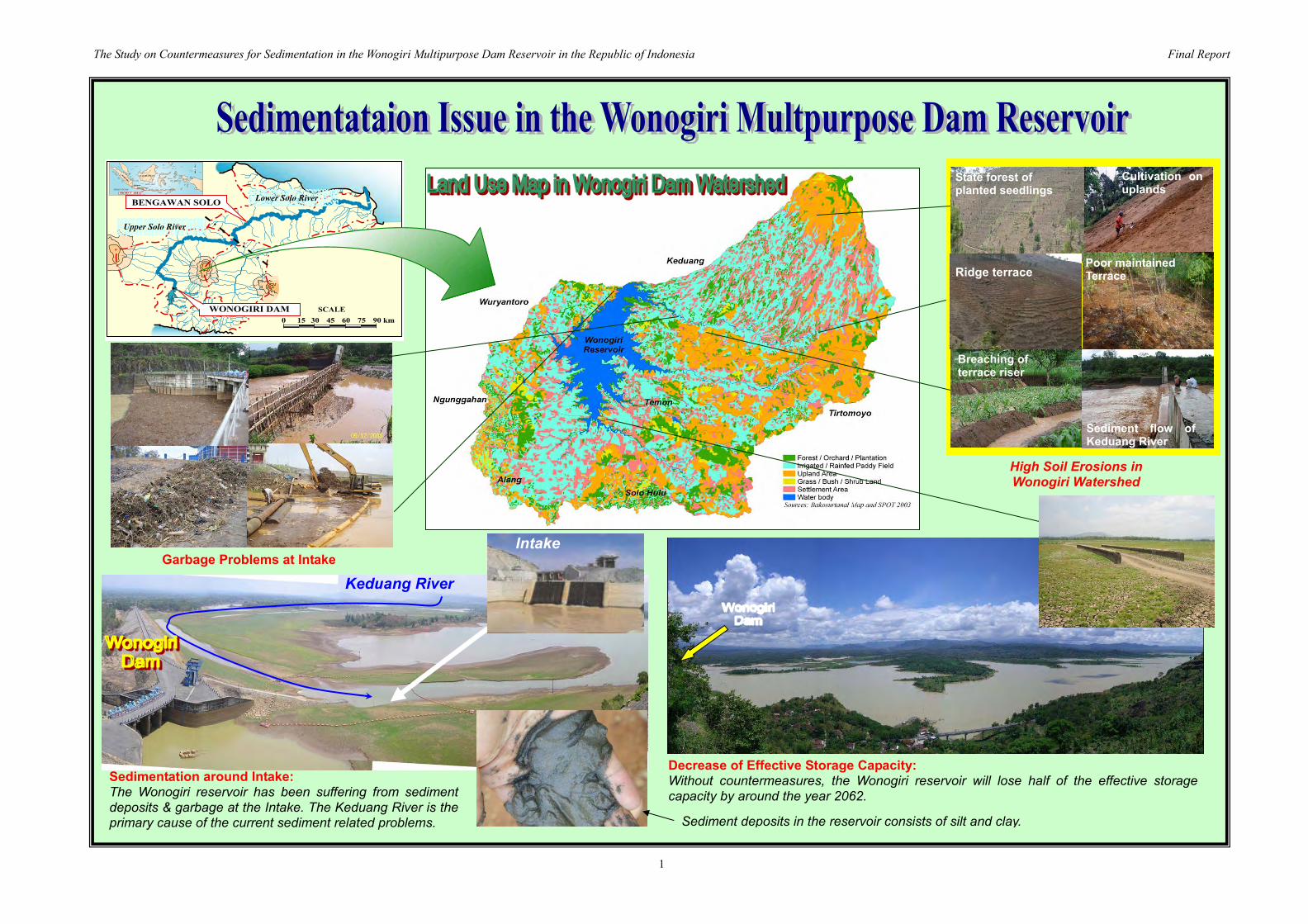
Sedimentation around Intake: The Wonogiri reservoir has been suffering from sediment deposits & garbage at the Intake. The Keduang River is the primary cause of the current sediment related problems.
High Soil Erosions in Wonogiri Watershed
Garbage Problems at Intake
Decrease of Effective Storage Capacity: Without countermeasures, the Wonogiri reservoir will lose half of the effective storage capacity by around the year 2062.
Sediment deposits in the reservoir consists of silt and clay.
Keduang River
State forest of planted seedlings
Ridge terrace Poor maintainedTerrace
Breaching of terrace riser
Sediment flow ofKeduang River
Cultivation on uplands
Intake

The Study on Countermeasures for Sedimentation in the Wonogiri Multipurpose Dam Reservoir in the Republic of Indonesia Final Report
2
Closure Dike (658 m)Closure Dike (658 m)
Overflow Dike (250 m)Overflow Dike (250 m)
New spillway (709 m)New spillway (709 m)
Sediment StorageSediment StorageReservoirReservoir
WonogiriWonogiri MainMainReservoirReservoir
PLTAPLTA
SpillwaySpillway
Retaining of sediment and garbage within the sediment storage reservoir
Sediment flushing/sluicing without using the stored water in the Wonogiri main reservoir
Mid-term Plan: Countermeasures for sediment inflow from other tributaries Watershed Conservation in Other Tributaries to reduce the sediment yield rate
Urgent Plan:Countermeasures for garbage and sediment inflow from Keduang River a. Sediment Storage
Reservoir with New Gates
b. Watershed Conservation in Keduang Watershed
c. Periodic Maintenance Dredging at Intake
The Master Plan was formulated to secure the proper function of the intake and to keep in order the Wonogiri reservoir function with provision of combination of structural and non-structural measures.
Satellite Picture at RWL EL.135.28 m on May 5, 2003

The Study on Countermeasures for Sedimentation in the Wonogiri Multipurpose Dam Reservoir in the Republic of Indonesia Final Report
3
PRESENT FUTUREPRESENT FUTURE
Well Maintained Terrace , July 2006
Components of Watershed Conservation a. Soil Conservation Measures
- Physical Measures (improvement of bench terraces, waterways, drop structures and side ditches in the settlement area)
- Vegetation Measures (stabilization of lip and riser of terraces, and hedge row at fringe of housing yard)
b. Agro-forestry Development c. Support Programs
Rate of Soil Lossper (3) proposed terrace
16.2 9.8 1.0
Original slopeBackward Slope ±
Lip
Terrace Drain
Bench
Riser
Stone
Improved Bench Terrace
Waterway
Note: Conditions of test site; Location: Slogohimo, Land use: Upland, Present terrace condition: Bench terrace, Original vegetation: Maize, Slope: about 2%, Soil: Latosol.
(1) Bare land (2) Present terrace (3) Proposed terrace
Jan. 10
Feb. 19
Jun. 29
0 – 8% 8 – 15% 15 – 25% 25 – 40% >40%
95%5%
62.5 %
37.5%
50%
25% 75%
12.5%
87.5%
Fruits/Trees
Seasonal Crops
50%
0 – 8% 8 – 15% 15 – 25% 25 – 40% >40%0 – 8% 8 – 15% 15 – 25% 25 – 40% >40%
95%95%5%5%
62.5 %62.5 %
37.5%37.5%
50%50%
25%25% 75%75%
12.5%12.5%
87.5%
Fruits/Trees
Seasonal Crops
50%
Local people / farmer People Participation in Village Assessment
Agro-Forestry Development Improvement of Bench Terraces

S-1
SUMMARY OF FINAL REPORT
Part I: Master Plan Study
A. INTRODUCTION
Objectives of the Study 1. The objectives of the Study are to:
i) Formulate a master plan for sustainable countermeasures for sedimentation problems in the Wonogiri multipurpose dam reservoir,
ii) Conduct a feasibility study of the selected priority project(s), and iii) Transfer technology to counterpart personnel in the course of the Study.
2. The goals after achievement of the above objectives are to:
i) Implement the project to be proposed under the Study to secure the long-term ability of the reservoir to supply water for irrigation and hydropower generation, and
ii) Provide solutions and technical approaches for reservoir sedimentation problems which are increasing concern in Indonesia.
Study Area 3. The Study Area covers; i) the entire catchment of the Wonogiri dam (reservoir area of 90 km2 and remaining catchment area of 1,260 km2), and ii) downstream reaches of the Bengawan Solo River from the Wonogiri dam to the confluence with the Madiun River.
Overall Schedule of the Study 4. The Study was carried out in accordance with the Scope of Works which was agreed between DGWR and JICA Preparatory Study Team in March 2004. The Study is divided into two phases, namely Phase I: Formulation of Master Plan and Phase II: Feasibility Study on the Selected Priority Project(s). The Study is scheduled to be carried out over 36 months starting in August 2004 and ending in July 2007.
Aug Sep Oct Nov Dec Jan Feb Mar Apr May Jun Jul Aug Sep Oct Nov Dec Jan Feb Mar Apr May Jun Jul Aug Sep Oct Nov Dec Jan Feb Mar Apr May Jun Jul
1 2 3 4 5 6 7 8 9 10 11 12 13 14 15 16 17 18 19 20 21 22 23 24 25 26 27 28 29 30 31 32 33 34 35 36
Works inIndonesia
Works inJapan
Report
THIRD YEAR
FY 2006FOURTH YEAR
FY 2007FIRST YEAR
FY 2004SECOND YEAR
FY 2005
First Works
Preparatory WorksFirstWorks
ThirdWorks
Second Works Third Works
IC/R DF/RIT/RP/R(3)P/R(2)P/R(1) F/R
FHASE 1 PHASE 2
Fourth Works
Overall Schedule of the Study
B. PRESENT CONDITION OF THE STUDY AREA
Socio-economic Condition 5. The population of the Wonogiri dam watershed area (corresponding to kabupaten Wonogiri, 1,007 thousand people as of 2004) accounted for about 3.1% of the total population of Central Java Province. The average annual population growth of Indonesia during the period of 1990-2000 was

S-2
1.49% (0.94% for Central Java Province), while the Population Census confirmed annual growth rate is 1.45% in 2005. The population growth slowed down as compared with the average annual growth rate of 2.42% for the period of 1971-1980 and 1.95% for the period of 1980-1990 (1.17% in Central Java). The general decrease happened mostly due to the family planning programs. The out-migration of people to cities is very intensive, especially over the last years.
6. With the rapid growth and economic transformation, the agricultural share in GDP declined to 19.4% in 1990, while the manufacturing and industry share in GDP increased from 28.8% in 1969 to 34.4% in 1989. Recently, the services sector has expanded (in 2004 it accounted for 40% of GDP and employed over one third of the working population). However, in the Wonogiri dam watershed area, agriculture sector still prevails, both in terms of GRDP and employment. The economy of kabupaten Wonogiri still remains heavily dependent on agriculture, even though the irrigation is scarce. The low incomes from agriculture hindered development of the industries and services. The people needing off-farm incomes have no choice to look for the job opportunities in the larger cities.
7. In the Wonogiri dam watershed area in 2002, the people who had a desperate income of less than Rp.102,900 per month were considered poor. There were over 246 thousand poor people in the Wonogiri dam watershed area that is equivalent to about 25% of the total population. Poverty has remained high, partly because of insufficient employment creation.
Meteorology and Hydrology 8. Mean annual rainfall of the Wonogiri catchment is around 1,990 mm based on the data at 36 stations between 1975 and 2005. Annual mean daily evaporation rate at the Wonogiri dam site is 5.3 mm/day. Evaporation in the dry season of July to November is relatively higher than that in the wet season of December to June.
9. The Wonogiri reservoir experienced inflow of large-scale floods with peak discharges exceeding 2,000 m3/s. One such large-scale flood occurred immediately after completion in 1980 and the largest flood peak discharge was recorded at 2,880 m3/s on February 5, 1988, followed by the 1985 flood of 2,720 m3/s.
10. Hourly reservoir inflows from five major tributaries in 1993-2005 were estimated based on the reservoir operation records and simulated hourly discharges. The table below shown the estimated mean monthly inflows from major tributaries on the hydrological year basis in 1935-2005.
Estimated Mean Monthly Dam Inflow from Major Tributaries in 1993-2005 (Unit : 106 m3 )
Tributary N D J F M A M J J A S O Annual
Keduang 22.9 38.7 50.0 81.1 82.6 44.6 10.7 7.5 5.0 2.2 3.2 5.9 354.3 Tirtomoyo 11.6 26.7 29.9 49.0 48.5 26.9 6.3 4.4 3.4 0.6 0.3 2.8 210.4 Temon 2.2 5.0 6.7 10.3 9.7 5.1 1.1 0.8 0.5 0.0 0.1 0.5 41.9 Bengawan Solo 8.1 17.7 22.2 36.0 34.9 16.4 3.8 3.0 2.0 0.2 0.3 1.8 146.4 Alang 7.8 15.2 18.7 27.4 30.0 12.3 3.0 2.4 1.0 0.1 0.2 1.7 119.8 Remaining Area 7.0 13.6 16.5 25.5 25.0 13.7 3.5 2.5 1.7 0.4 0.6 1.8 111.7 Whole Catchment 59.6 116.9 144.1 229.3 230.6 119.0 28.3 20.5 13.6 3.6 4.7 14.3 984.4
Soils and Land Use 11. The soils distributed in the Wonogiri dam watershed are classified into four soil types of Mediteran (42% of the whole area), Litosol (25%), Latosol (12%) and Grumusol (21%). All of these soils are fine textured (clay to silty clay) and their soil fertility is generally poor, being susceptible to water erosion. Among them, Mediteran and Latosol are categorized as highly fragile to surface soil erosion.

S-3
12. The present watershed land use is summarized below. About 90% of the watershed comprises paddy field, home settlement area, upland field and orchard/plantations. Forests cover less than 1% of the watershed. These values reflect a high population density in the Wonogiri dam watershed.
Present Land Use of Wonogiri Dam Watershed Land use Area (ha) Ratio (%)
(1) Paddy field 30,495 24.5 (2) Home Settlement Area 26,764 21.6 - Housing yard and garden 7,289 5.9 - Upland in settlement area 19,475 15.7 (3) Upland field 39,761 32.0 (4) Orchard/ Plantation 12,867 10.3 (5) Forest 281 0.2 (6) State forest 12,779 10.3 - Forest 385 0.3 - Other land use (areas covered with young trees
reforested and upland crops in State forest) 12,394 10.0
(7) Others (lakes, roads, rivers and other use) 1,384 1.1 Total 124,331 100.0
Source: Results of JICA field survey and interpretation of Satellite image, and data of BAKOSURTANAL
Agriculture 13. The agriculture sector is the largest economic sector in Wonogiri and contributed 52% of the GRDP in 2002. Within the sector, the crop sub-sector is a leading sub-sector accounting for about 85% of the sector GRDP. The crop sub-sector is characterized by paddy field (wet land farming) food crops and upland (dry land farming) food, horticulture and estate crops. Wet land farming is practiced in paddy fields covering low-lying areas and rice terraces constructed on sloping land. The dry land farming is extensively practiced in terraced fields constructed on moderate to steep sloping land. The primary crop in the wet land is paddy (wet land rice), while in upland, diversified seasonal crops and perennial crops are produced.
Forestry and Watershed Management 14. The forest areas in the Wonogiri dam watershed are categorized into state forest and people’s forest. The state forest is managed and controlled by State Forest Company and the people’s forest is under the control of individual land owners. In the people’s forest, community based forestry development activities are promoted by the regional forestry services office. The people’s forest areas are said to be some 13,900 ha. All the people’s forests are man-made forests and a greater part of them are managed under an agro-forestry system.
15. The state forest areas related to the Wonogiri dam watershed under the control by BKPHs are about 22,000 ha, consisting of protection forest (3,400 ha), production forest (17,300 ha) and less productive forest (1,300 ha). Among those areas, there are about 12,800 ha within the Wonogiri dam watershed. The substantial degradation of the state forest is reported to have been caused mainly by illegal logging during the reformation of political regime in 1998/99. The protection forests are mostly natural forests and partly afforestated areas that are found only in the upper reach of the Keduang River basin.
16. Community based forestry development is ongoing under GERHAN (National Movement for Forest and Land Rehabilitation) program. GERHAN has been planned for the period of 5 years from 2003 to 2007. The Wonogiri dam watershed is one of the main targets of the national project for watershed conservation. The national budget under GERHAN allocated for the Wonogiri was Rp.8,950 million in 2003 and Rp.11,283 million in 2004. These programs were applied to about 11,000 ha of the people’s forest in 2004.

S-4
C. CURRENT STATUS OF WONOGIRI RESERVOIR SEDIMENTATION
Operation of Wonogiri Reservoir 17. Mean annual inflow volume into the Wonogiri reservoir was approximately 1.23 billion m3 in 1983-2005, and mean annual water release from spillway (spill-out) was around 18% of the total outflow volume or 210 million m3. The remaining volume (82% or 932 million m3) was used for hydropower generation and irrigation water supply. Mean monthly inflow is highest in February at 110.8 m3/s (268 million m3), and in August at its lowest at 2.3 m3/s (6 million m3).
18. For flood control, the reservoir water level is controlled not to exceed the Control Water Level (El.135.3 m) during the flood season to eliminate the possibility of the PMF overtopping the dam crest. The reservoir provides 220 million m3 of flood control capacity to regulate the standard highest flood discharge with peak discharge of 4,000 m3/s to the constant outflow of 400 m3/s.
19. Immediately after completion of the Wonogiri Irrigation Project in 1986, the water supply to the Wonogiri irrigation system was commenced. Irrigation water is taken from the Colo intake weir located about 13 km downstream of the Wonogiri dam. At present, the irrigation area has been extended from 24,000 ha in the original plan to 29,330 ha where triple or double cropping farming is being practiced. Mean monthly discharges at the Colo weir in 1986-2005 are ranging from 22 to 30 m3/s in the dry season.
Current Status of the Wonogiri Reservoir Sedimentation 20. A number of studies to evaluate the reservoir sedimentation have been carried out. Sedimentation rates estimated by the previous studies were 15.6 million m3/year in 1980-1988 and 18.5 million m3/year in 1981-1993, etc.
21. An echo sounding survey with GPS was conducted for the Wonogiri reservoir over two periods from October to November 2004 (before entering the wet season) and June to July 2005 (after the wet season) to clarify the current status of the sedimentation as well as the incremental sediment deposit in the wet season in 2004/2005. Around 114 million m3 or 16% of the total capacity 730 million m3 was lost due to sedimentation in 1980-2005. Around 13% of the original effective storage volume had been filled with sediment deposits by 2005. In other words, around 87% of the original effective storage zone is still usable.
Loss of Capacity of the Wonogiri Reservoir by Storage Zone between 1980 and 2005 Reservoir Capacity (106 m3) Capacity Lost due to SedimentationReservoir Zone
1980 2005 Value (106 m3) of Original (%)Flood Control Storage (El. 135.3 – 138.3 m) 232 230 2 0.9 Effective Storage (El. 127.0 – 136.0 m) 433 375 58 13.4 Dead Storage (below El. 127.0 m) 114 58 56 49.1
Garbage Problems at Intake 22. Considerable quantity of vegetative debris and garbage washes into the intake forebay area at the beginning of the wet season. Partial blockage of the power intake by garbage frequently occurs. The intake trash racks are blocked by garbage causing the intake shut down. The trash racks are cleaned by divers. All of the garbage comes from the Keduang River.
Monitoring on Sedimentation in front of Intake 23. The intake structure has been seriously affected by sediment inflowing from the Keduang River. PBS has been periodically monitoring sediment levels in front of the intake. It appears that the opening space between the sediment level and top of the intake was about 3.3 m in July 2005, while the total opening space was 11.0 m. Sediment levels were stable for the dry season. Sediment level rose by 2.1 m for the wet season from October 2005 to July 2005.

S-5
D. EROSION SOURCES AND SEDIMENT YIELDS FROM WONOGIRI DAM WATERSHED
24. Erosion sources for the sediment deposits in the Wonogiri reservoir were identified according to the visible erosion sites in the Wonogiri catchment; i) soil erosion of land surface, ii) gully erosion, iii) landslide (slope failure), iv) riverbank erosion, and v) slope erosion of the roadside. Field investigation and GIS analysis were performed to estimate annual sediment yields from respective erosion sources.
25. Average annual sediment yield into the Wonogiri reservoir in 1993-2004 was 3.18 million m3. The dominant erosion source was soil erosion from the surface of the land. Its volume is 93% of the total, while sediment yields from other sources was only 7%.
Annual Sediment Yield into the Wonogiri Reservoir by Source and River (Unit : m3)
River System Gully
Erosion Landslide Riverbank
Roadside Slope
Surface Soil Erosion
Total
Keduang 67,880 2,930 9,780 3,690 1,134,300 1,218,580Tirtomoyo 90 11,730 19,760 2,480 469,700 503,760
Temon 30 0 11,350 600 61,000 72,980Solo 220 440 11,040 1,990 591,300 604,990
Alang 7,330 0 66,620 730 326,600 401,280Others 0 0 11,850 1,170 363,900 376,920Total 75,550 15,100 130,400 10,660 2,946,800 3,178,510
E. RESERVOIR SEDIMENTATION ANALYSIS
Reservoir Sedimentation Analysis Model 26. Numerical modeling was employed to analyze the flow condition and potential for sedimentation in the Wonogiri reservoir. A numerical method can provide an advantage in evaluating extreme conditions with the same temporal and spatial scales. A depth-averaged model is appropriate for evaluating flow condition and sedimentation in the Wonogiri reservoir because of its wider and shallower features of the domain. A depth-integrated two-dimensional numerical model, NKhydro2D sediment transport model was employed.
Simulation for Reservoir Sedimentation 27. Sediment inflow during the wet season of 2004/2005 was 2,452,000 m3 (deposition base), in which the sedimentation was 2,317,000 m3 during the season. The flow velocity in river area was fast during flood, while that in the center of the reservoir was very much slow. Counter flow to the center due to the flood in Keduang River occurred. SS concentration in river area during flood was higher and the muddy current was inversely transported into the center of the reservoir from the Keduang River. There was almost no sediment exchange between the Keduang area and the upstream area. The computed sediment release through the intake was about 141,000 m3, consisting of almost clay only. With the basis of sediment from the Keduang River, the trap ratio of clay by the reservoir was 74-76%, although silt and the coarser sediments were almost all trapped. Most sedimentation occurred in the river area (mouth) and the sedimentation reduced gradually to the center of the reservoir. Sedimentation in the old river course area was about 0.1-0.3 m, while that in the center of the reservoir was less than 0.02 m.
F. VERIFICATION TEST OF HYDRO-SUCTION DREDGING SYSTEM
28. A verification test of the hydro-suction dredging system was carried out in front of the intake from September 12th to October 31st , 2005. The test using the side rotary excavator was carried out for

S-6
sixteen different conditions of changing depth and flow rate. The density of the sediment in the pipeline was proportion to the flow velocity. When a flow rate in the sediment passing pipe was around 12 m3/min, density and volumetric sediment concentration conveyed by the system were approximately 1.09 g/cm3 and 13%, respectively. Though a tendency for consolidation was found in the result of the core drilling, there were no serious problems that made the dredging difficult. The verification test confirmed that the hydro-suction system using side rotary can be applied to dredging of sediments in front of the intake at the Wonogiri dam.
G. BASIC STRATEGY FOR MASTER PLAN FORMULATION
Projection of Wonogiri Reservoir Sedimentation 29. With a simple focus on the rate of reservoir capacity loss, the future status of the Wonogiri reservoir can be projected for the case where there are no countermeasures to the sedimentation issues. By the year 2051, the Wonogiri reservoir will lose around 28% of its effective storage capacity and completely lose its dead storage capacity. The reservoir will lose about 62% of the effective storage capacity by around the year 2105.
Goal of Master Plan 30. From the realistic viewpoint, it is considered difficult to exploit other reservoir sites in Java on a similar scale to the Wonogiri reservoir. Although the complete restoration of the Wonogiri reservoir is a very hard task, the sustainable management of the Wonogiri reservoir function is crucial for preserving the welfare of all the stakeholders in the basin. Hence, it is recommended that the Wonogiri reservoir shall be operated in a sustainable manner through provision of an effective reservoir sediment management system to prolong the reservoir lifetime.
31. The proposed master plan will provide the framework and indicates the direction towards which comprehensive sediment management of the Wonogiri reservoir should go. The measures to be proposed shall be realistic and practical ones. Further, it is highly expected that the Study will provide solutions and technical approaches for the similar sedimentation problems in other existing reservoirs in Indonesia.
32. Goals of the master plan are:
i) The Wonogiri dam should continue to contribute to the stabilization of people’s livelihood as well as improvement of social welfare for at least the next 100 years. This goal will be only achieved by protecting and maintaining the expected function of the Wonogiri reservoir in terms of flood control, irrigation water, domestic and industrial water supply and hydropower generation.
ii) The Wonogiri reservoir has to be safe whatever happens in the future. This goal will be realized by careful observance of the reservoir operation rule. The Wonogiri reservoir should be operated properly and safely in the occurrence of floods of any magnitude.
iii) Sustainable management of the Wonogiri reservoir will be achieved through the linkage with management and conservation of the Wonogiri dam watershed. The Wonogiri dam watershed has to be managed and conserved in harmony with improvements in the quality of life of farmers within its watershed.
Basic Strategy for Master Plan Formulation 33. To achieve the goal, basic strategy for formulation the master plan was set up:
i) Every year around 3.18 million m3 of sediment enters the Wonogiri reservoir. It was determined that the target design sediment deposition in the reservoir should be less than the rate of 1.2

S-7
million m3/year adopted in the original design in 1978.
ii) Top priority should be placed on measures to protect the intake structure. Countermeasure for handling sediment and garbage inflow from the Keduang River will be the most urgent measure.
iii) It will be a long time before the sediment inflows from other tributaries cause serious impacts on the intake. It is considered to be practical to adopt a watershed conservation policy to reduce the sediment yield rate therein as mid-term measure.
iv) Complete restoration of the reservoir will require huge expenditure and acquisition of vast spoil bank areas. Due to constraints, the most practical way is to reduce sediment inflow into the reservoir through watershed conservation to an extent that extends the reservoir lifespan.
v) The Wonogiri reservoir has been operated to raise the original NHWL by around 1 m from 1991 to store additional water of around 75 million m3 to meet the strong water demands of the downstream water users. The current reservoir operation practice was assessed to be unsafe in view of the dam safety. Although the observance of the original operation rule will lead to reduction of the current water supply capacity, all the stakeholders have to recognize that the dam safety is of the utmost importance. Technical evaluations and preliminary design of alternative structural measures should be conducted under full observance of the current reservoir operation rule.
H. TECHNICAL EVALUATION ON STRUCTURAL SEDIMENT MANAGEMENT ALTERNATIVES
Conceivable Structural Alternatives 34. Conceivable structural alternative countermeasures were worked out for; i) sediment deposits and garbage at the intake, ii) sediment inflow from the Keduang River, and iii) sediment inflow from other tributaries. Technical effects on mitigation of sedimentation in reservoir due to alternatives were evaluated by the calibrated reservoir sedimentation analysis model.
Countermeasures for Sediment Deposits and Garbage at Intake 35. Function of the existing intake should be properly secured. Alternative measures shall cope with both garbage and sediment inflows from the Keduang River. The alternatives of modification and relocation of the intake are inferior to other alternatives because water supply has to be suspended during construction and construction cost is higher. Sedimentation problems could not be completely solved by these alternatives.
36. Sediment trapping structure both at the Keduan River and the intake are useful to prevent garbage from entering into the intake. Hydraulic dredging or hydro-suction sediment removal system seems reliable measures to remove the sediments and garbage at the intake, though huge O&M cost is required every year. In conclusion, none of the alternatives provides a sustainable solution to the sediment and garbage issues at the intake. These alternatives might become a supplemental component of the permanent structural countermeasures.

S-8
Conceivable Structural Alternatives for Wonogiri Reservoir Sedimentation Issues
Countermeasures for Sediment Inflow from Keduang River 37. The Keduang River sediment bypass requires huge construction cost and would cause adverse impacts with larger magnitude compared to other two alternatives. The structural difference between the sediment sluicing with new gates and a sediment storage reservoir is simply the construction of both closure and overflow dikes in the reservoir.
38. Sediment storage reservoir would be more advantageous in view of technical factors:
i) Almost all of the garbage inflow from the Keduang River would be completely retained within the sediment storage reservoir. The retained garbage in the sediment storage reservoir would be easily released through the new gates when sediment releasing operation is carried out.
ii) The majority of the sediment inflow from the Keduang River would be deposited within the sediment storage reservoir. Although small parts of the sediment inflow into the sediment storage reservoir would enter the Wonogiri main reservoir through the overflow dike, sedimentation at the intake would be drastically decreased. This significant technical merit overcomes the alternative measure of sediment sluicing by new gates.
iii) Sediment sluicing has to be performed from the beginning of wet season when the reservoir water level is lowest. Sediment deposits in the sediment storage reservoir could be released, whenever necessary, without using the stored water in the Wonogiri main reservoir. The sediment storage reservoir can be operated independently from the Wonogiri main reservoir.
Countermeasures for Sediment Inflow from Other Tributaries 39. If the sediment deposits can not be released, a conceivable way would be to mechanically remove the sediment deposits in reservoir. However because of the limited space for spoil on the bank area near the reservoir, it is unrealistic to dispose the sediment deposits from the reservoir as well as the trapped sediment deposits from the sediment storage dams. No economical and sustainable
Countermeasures Method
Issues and Problems
1) Sediment deposit at and around Intake
2) Decrease of effective storage volume
3) High sediment yield in watershed
Countermeasures for Sediment Deposits and Garbage at Intake
Countermeasures for Sediment Inflow from Keduang River
Watershed conservation
1) Modification of the intake 2) Relocation of the intake 3) Garbage trapping structure at the intake 4) Garbage trapping structure in Keduang River 5) Hydro-suction sediment removal system 6) Hydraulic dredging
1) Keduang River sediment bypass 2) Sediment sluicing by new gates 3) Sediment storage reservoir with new gates in
the reservoir
Considered separately
Countermeasures for Sediment Inflow from Other Tributaries
1) Sediment storage dam for sediment removal 2) Hydraulic dredging in reservoir 3) Dry excavation in reservoir 4) Managing of sediments within reservoir by
water releasing from the intake 5) Dam heightening

S-9
solution will be provided by all of the structural alternatives.
40. The most practical and sustainable measure is to reduce sediment yield as much as possible from the Wonogiri dam catchment by means of watershed conservation. Watershed conservation works would be superior to the structural alternatives.
I. PLANNING FOR WATERSHED CONSERVATION AND MANAGEMENT
Soil Erosion Sources and Target Areas for Watershed Conservation 41. The total annual average soil loss from the Wonogiri dam watershed is estimated at about 17.3 million tons, mainly consisting of; i) 9.1 million tons or 53% of total soil loss from upland fields, ii) 3.8 million tons or 22% from settlement areas under upland field condition, iii) 1.8million tons or 10% from settlement areas, and iv) 1.5 million tons or 8% from the State forest as summarized below. These four main soil erosion sources cover over 90% of the total soil loss from the Wonogiri dam watershed. Soil loss from other land use categories is within an acceptable scale. State forest area is under control and management of the State Forest Corporation and reforestation programs are ongoing. Three river basins such as the Keduang, Tirtomoyo and Upper Bengawan Solo are the main producer of soil loss occupying around 80% of the total soil loss in the whole basin.
Estimated Annual Soil Loss by River and Land Use (unit: 1,000 ton)
Keduang 12 961 1,797 1,726 363 11 4 238 5,112 30Tirtomoyo 3 450 732 2,911 235 0 7 448 4,786 28Temon 0 39 136 660 52 0 1 85 973 6Upper Solo 1 211 588 2,403 298 0 7 299 3,807 22Alang 1 42 245 521 31 0 6 210 1,056 6Ngunggahan 1 27 128 438 25 0 6 152 777 4Wuryantoro 0 18 108 197 35 1 0 1 360 2Remnant 0 12 58 264 31 2 1 37 405 2
Total 18 1,760 3,792 9,120 1,070 14 32 1,470 17,279 100
StateForest
Total(ha)
PaddyFieldRiver Settlement
Area UplandUpland inSettlement
OrchardPlantation Forest Others Ratio
(%)
42. The total subject area for watershed conservation amount to 66,000ha (or 54% of the whole watershed) consisting of upland (39,800 ha or 32%), settlement area under upland field condition (7,300 ha or 16%) and settlement area (19,500 ha or 4%). Three watersheds of the Keduang, Tirtomoyo and Upper Solo Rivers are the main producer of soil loss in the Wonogiri dam watershed and occupy about 80% of the total soil loss.
Basic Development Concept and Approach 43. Past efforts for the watershed conservation in the Wonogiri dam watershed area were under the Upper Solo (Wonogiri) Watershed Protection Project financed by IBRD and implemented by Ministry of Forestry from 1988/89 to 1994/95. After the project, activities for the conservation of watershed were continued in a limited scale by utilizing district, provincial and national budgets. In 2003, GERHAN was launched for the scheduled period of 2003 to 2007 and conservation activities in the watershed area were restored to a more substantial level.
44. Basic development concept for watershed conservation project is set up based on the lessons learned from the past watershed conservation efforts, the results of needs of local community and the survey results:
From the Viewpoint of Soil and Water Conservation and Agricultural Production: i) Introduction of improved bench terraces as well as vegetative conservation measures along with
agricultural measures is recommendable for expectation of economical viability of the project
S-10
and for ensuring synergy effects of both measures. ii) Agro-forestry development (fruits, estate crops, tree, etc) will be made to prevent soil erosion and
to increase agricultural productivity as well as to provide the next generation of farmers with resources of other agricultural incomes.
iii) Introduction of specific improved technology on soil and water conservation measures, cropping pattern, farming practices for increasing crop yields based on assessment farmer’s capability, the present conditions, land suitability and potential.
iv) Reinforcement of soil erosion prevention from the fringe of the yard by construction of hedgerows and side ditches.
From the socio-institutional viewpoint: i) A community-based conservation management system that fully reflects conservation-oriented
awareness of the farmers in the project area will be basically adopted. Community will take a leading role for the watershed conservation from the stage of planning to the stage of monitoring after project construction through the stage of project constriction.
ii) Organization setting up at village level establishment of an implementation committee at village level with transparency in all the process relevant to the project implementation.
iii) An adequate coordination organization will be established at the district level to smoothly execute the collaborative activities of all stakeholders, communities and implementing agency for the implementation of the watershed conservation project.
iv) Proper incentives such as partial subsidy to labor and material costs and training program will be provided to beneficiary farmers to increase the motivation of the people. Also a small scale village grant fund system will be established.
v) Important information on the watershed and the reservoir will be disseminated to the local people, especially to the young generation.
Formulation of Watershed Conservation Measures 45. The proposed land use depending on slope class was planned taking into account the following issues: i) sustainable soil and water conservation measures and agricultural productivity increase and diversification through the promotion of agro-forestry, and ii) mitigating the labor burden in future farming activities through the expansion of fruit/estate crops cultivation to accommodate the gradually aging of farming communities and tendency for the next generation to seek non-farm job opportunities. To ensure immediately effective and long-term sustained watershed conservation, it is planned that all the upland shall be installed with bench terrace.
46. For strengthening of supports for farmers in executing watershed conservation, technical and financial supporting programs shall be formulated. The programs are; i) Support program for soil and water conservation consisting of (a) empowerment of beneficiary framers and farmer groups, (b) support programs for operation/implementation of conservation measures, (c) field staff empowerment program, ii) Support program for land management and agricultural promotions, iii) Support programs for community development, and iv) Monitoring and evaluation at village level.
Selection of Subject Area for Watershed Conservation 47. Target project areas were classified into 35 land units in total in terms of slope class, current condition of each terrace type. Target subject area was selected based on the volume of soil loss from land unit. Finally 180 villages were selected for implementation with a total area of about 34,400 ha.
48. Implementation of the project will be carried out by community-based management. To avoid the conflict amongst villages, the project should be implemented in all the villages located in the same tributary basin. In the uplands where there are existing bench terraces, terrace improvement

S-11
works, drainage works and agricultural promotion works are mainly proposed. In the uplands and settlement areas with traditional terraces, upgrading works of the terrace as well as water way and agro-forestry promotion are focused. Construction of hedge rows at fringe of the yards and side ditches along the yards are proposed to mitigate soil erosion from housing yards.
49. The proposed implementation arrangement at field and village level will be initiated with the implementation committee to be established at the village level. The member of implementation committee should be selected with transparency in the beginning of the implementation under the guidance and support of the executing agency or NGOs or by the both. Under the committee, K2TA (water conservation farmer group) both at farmer/farmer group and village levels shall be instituted.
Expected Reductions of Soil Loss Production and Sediment Inflow into Wonogiri Reservoir 50. Annual average soil loss after implementation of the proposed projects was estimated 9,202 thousand tons by USLE comparing to 17,279 thousand tons under present condition as summarized below. Annual sediment inflow into the Wonogiri reservoir is expected from around 2.95 million m3 to 1.61 million m3.
Estimated Reductions of Soil Loss Production and Sediment Inflow Present Condition After Implementation Reduction
Sediment Inflow Soil Loss Sediment
Inflow Soil Loss Sediment Inflow Soil Loss River Basin
(1,000m3) (1,000 ton) (1,000m3) (1,000 ton) (1,000m3) (1,000 ton)Keduang 1,134 5,112 718 3,237 416 1,875 Tirtomoyo 470 4,786 229 2,331 241 2,455 Temon 61 974 29 457 32 517 Upper Solo 591 3,808 297 1,914 294 1,894 Alang 327 1,057 159 516 167 541 Ugunggahan 183 777 75 317 109 460 Wuryantoro 85 360 61 260 24 100 Remnant 96 405 40 170 55 235
Total 2,947 17,279 1,609 9,202 1,338 8,077
J. INITIAL ENVIRONMENTAL EXAMINATION (IEE)
51. The IEE concluded that the project components of master plan would not cause any significant adverse impacts, although there are minor negative impacts that can be mitigated by appropriate management. Because of the nature and scale of the project components, they are not subject to environmental assessment by Environmental Impact Assessment (AMDAL) in Indonesia. It may be judged that the project components should fall into Category B according to the JICA Guideline for Environmental and Social Considerations.
K. FORMULATION OF MASTER PLAN
Urgent Countermeasures for Garbage and Sediment Inflow from Keduang River 52. Watershed conservation will be implemented for a total area of 11,260 ha covering 83 villages. After implementation, around 0.42 million m3 of sediment inflow is expected to be reduced every year on the average. The annual sediment inflow from the Keduang River would be reduced from 1.22 million m3/year to 0.80 million m3/year.
53. From the reservoir sedimentation simulation, sediment volume overflow into the main Wonogiri reservoir from the sediment storage reservoir and released from hydropower generation were estimated 0.10 million m3/year and 0.14 million m3/year. Annual sediment deposits in the Wonogiri

S-12
reservoir are 1.92 million m3/year.
Wonogiri Dam
800
1,220
1,960
1,960
WatershedConservation
Wonogiri Main Reservoir
Overflow Dike
700
0
140
100800 1,960
Existing Spillway
Intake
Power Station
Balance : 0Balance : 1,920
(Sediment Deposits)
New Spillway
Sediment StorageReservior
Keduang River Basin Other River Basins
Bengawan Solo River 840
Unit: 1,000 m3
Closure Dike
Sediment Yield
Urgent Plan Design Annual Sediment Balance in the Wonogiri Reservoir by Urgent Countermeasure
Mid Term Countermeasures for Sediment Inflows from Other Tributaries 54. Watershed conservation will be implemented for a total area of around 23,120 ha that covers 29 villages in the Tirtomoyo, 8 villages in the Temon, 25 villages in the Upper Solo, 19 villages in the Alang, 7 villages in the Ngunggahan, 7 villages in the Wuryantoro River basins and 2 villages in the remaining area. After implementation, annual sediment inflow into the Wonogiri reservoir is expected to be reduced by 0.92 million m3. The annual sediment inflow would be reduced from 1.96 million m3/year to 1.04 million m3/year.
55. Annual sediment deposits in the Wonogiri reservoir are 1.00 million m3/year. The sediment balance satisfies the basic concept that allowable annual sediment deposition rate is less than the original design sedimentation rate of 1.2 million m3/year.

S-13
Wonogiri Dam
1,220
1,040
1,960
WatershedConservation
Wonogiri Main Reservoir
Overflow Dike
700
0
140
100800 1,040
Existing Spillway
Intake
Power Station
Balance : 0
New Spillway
Sediment StorageReservior
Keduang River Basin Other River Basins
WatershedConservation
Bengawan Solo River 840Unit: 1,000 m3
Balance : 1,000(Sediment Deposits)
Closure Dike
Sediment Yield
800
Mid Term Plan Design Annual Sediment Balance in the Wonogiri Reservoir by Mid Term Countermeasure
Prioritization of Proposed Countermeasures 56. The suggested prioritization of the proposed countermeasures is:
Prioritization of Proposed Countermeasures Phasing of Implementation Purpose
1. Urgent Countermeasure ▪ Keep proper function of the intake a. Sediment Storage Reservoir with New
Gate ▪ Pass through and flush out the inflow of sediment and
garbage from the Keduang River b. Watershed Conservation in Keduang
catchment ▪ Mitigate sediment yield in the Keduang catchment and
thereby reduce sediment inflow into the reservoir c. Periodic Maintenance Dredging at
Intake ▪ Avoid blocking at the intake due to sediment deposits and
garbage 2. Mid Term Countermeasure ▪ Keep in order the Wonogiri reservoir functions
a. Watershed Conservation in other tributaries
▪ Mitigate sediment yields from other tributary catchments and thereby reduce sediment inflow into the reservoir
3. Long-lasting Countermeasure ▪ Keep in order the Wonogiri reservoir functions a. Rehabilitation of Watershed
Conservation Areas ▪ Keep in order the conserved Wonogiri dam watershed
function
57. The continuous rehabilitation, after completion of the mid term countermeasures, is categorized as a long-lasting countermeasure. This countermeasure aims at maintaining soil erosion rates at the design levels to avoid renewed deterioration of cultivated farmlands and to keep them in the improved state. The long-lasting rehabilitation works are intended to be implemented using local

S-14
budget and under a funding framework that transfers some of the benefit from the downstream communities of the Wonogiri dam to the upstream ones. some of the benefit from the downstream communities of the Wonogiri dam to the upstream ones.
Implementation Program 58. Urgent plan should be commenced as early as possible to ensure proper function of the intake is maintained. Implementation of the mid term plan can be commenced in the latter part of the urgent plan. Since the high sediment yield in tributaries, other than the Keduang River basin, will continue even after the completion of the urgent plan, mid term plan should be commenced at the earliest opportunity to mitigate sediment yield and thereby to prolong the dam reservoir life.
Overall Implementation Schedule
1 2 3 4 5 6 7 8 9 10 11 12 13 14 15 16 17 18 19 20
1 URGENT COUNTERMEASURES(1) Financial Arrangement
(2) Sediment Storage Reservoir with New Gates
(3) Watershed Conservation in Keduagn River Basin(4) Procurement of One Dredger and Maintenace
d i2 MID TERM COUNTERMEASURES(1) Financial Arrangement
(2) Watershed Conservation in Other Tributaries
1) Tirtomoyo2) Upper Solo3) Alang4) Temon5) Ngunggahan6) Wuruyantoro7) Remnant basins
3 LONG-LASTING COUNTERMEASURES(1) Rehabilitation of Watershed Conservation Areas
4 MONITORINGPeriodic Monitoring for Sedimentation at IntakePeriodic Monitoring for Sedimentation in Reservoir
Legend: Financial Arrangement Design Implementation Procurement
2006 2010 201515 years 20 years
2020 2025Measures 5 years 10 years
Project Cost 59. Total project cost is as estimated below:
Summary of Project Cost
Countermeasures Cost (US$ thousand) 1. Urgent Plan
a. Sediment Storage Reservoir with New Gates 36,070 b. Watershed Conservation in Keduang Catchment 13,835 c. Procurement of One Dredger 3,586
Sub Total 53,491 2.Mid Term Plan
a. Watershed Conservation t in Tirtomoyo Catchment 10,433 b. Watershed Conservation in Upper Solo Catchment 11,049 c. Watershed Conservation in Temon Catchment 2,418 d. Watershed Conservation in Alang Catchment 4,856 e. Watershed Conservation in Ngunggahan Catchment 2,807 f. Watershed Conservation in Wuruyantoro Catchment 2,148 g. Watershed Conservation in Remnant Catchment 1,349
Sub Total 35,060 Grand Total 88,551

S-15
Economic Evaluation 60. The economic feasibility of the Project is evaluated by calculating the economic internal rate of return (EIRR) for 50 years after the completion of the Project. The project benefit is defined as the difference of the profit between the future with project and without project conditions. The project benefits consist of irrigation, hydro-power and watershed benefits. In case of irrigation and hydro-power benefits, it is assumed that without the project, the intake to provide for irrigation and hydro-power will cease to function by the year 2022 because the forebay of intake will be fully of sediments. The benefit from the watershed projects is as the incremental production of agricultural crops from land improvement and from fruit tree planting in the bench terrace areas. The EIRR of the Project is 16.4%. The Project is considered to be economically feasible.
Capacity for Operation and Maintenance 61. PJT I Bengawan Solo is responsible for the operation and maintenance of the Wonogiri dam (the responsibility was transferred by PBS in 2003). The main revenues of PJT I Bengawan Solo come at present from tariff collection for the Wonogiri dam water from: i) PLTA Wonogiri (hydropower generation), and ii) domestic and industrial users. These revenues can be used to cover the O&M expenditures. The revenue in 2005 was Rp. 6,101 million.
62. PJT I Bengawan Solo can spend up to 30% of its revenues on the O&M expenditures. In 2005, the O&M expenditure was about 24% of the revenue.
Current Institutional Issues and Recommendation for Watershed Management 63. An institutional study of the management of the Wonogiri dam watershed has been carried out at local, provincial and national levels. In general, the existing institutional framework for watershed management seems adequate. However, some significant issues were identified for which remedial actions have been recommended. The most important of these are summarized in the table below.
Main Issues and Recommendations Issue Recommendation
1. Lack of law enforcement (leading to uncontrolled illegal activities in private / state forest areas)
Establish multi-sectoral taskforce in Kabupaten Wonogiri backed by Central and East Java governors, national authorities and funding
2. Lack of funds and other resources at kabupaten and province levels
More funds to be transferred from central government (Ministries of Forestry, Agriculture) as part of otonomi daerah decentralization, plus local efficiency drive. Increase field staff strength and resources in forestry and agriculture kabupaten
3. No adequate mechanism for multi-sectoral management of the Wonogiri dam watershed
Establish immediately a Wonogiri dam Watershed Coordination Committee with members from Wonogiri and Pacitan kabupaten
4. No standard Central Government regulation of both private and state forests. State forests contribute significant sediment run-off
BPDAS Solo (reporting to Ministry of Forestry) to regulate the work of State Forestry Corporation (as well as non-state forest) in Solo river basin
5. Insufficient importance attached to watershed management
In addition to the above, Sub Dinas Forestry in Kabupaten Wonogiri to be upgraded to full Dinas

S-16
Part II: Feasibility Study
L. PROJECT AREA
64. At the Steering Committee meeting held on July 19, 2006, the Master Plan for sustainable countermeasures for sedimentation issues in the Wonogiri reservoir was approved. Priority projects covering the urgent countermeasures proposed in the Master Plan was also approved, subject to a feasibility study in Phase II of the Study. The urgent countermeasure (the Project) comprises three components; i) construction of sediment storage reservoir with new gates, ii) watershed conservation works in the Keduang River basin, and iii) procurement of dredger for periodic maintenance.
65. The Feasibility Study was commenced in July 2006 as Phase II of the Study. Total duration of the feasibility study was scheduled to be 8 months ending in February 2007. During the feasibility study, the field investigations; i) topographic survey for the sediment storage reservoir site, ii) geological investigation and laboratory tests, and iii) environmental impact assessment (EIA) of the Project, were carried out, entrusted to the local contractors and university.
66. The Project Area covers i) the Wonogiri dam and reservoir (reservoir area of 90 km2), ii) Keduang River basin (catchment area of 421 km2), and iii) downstream reaches of the Bengawan Solo River from the Wonogiri dam to the confluence with the Madiun River.
M. FEASIBILITY DESIGN OF SEDIMENT STORAGE RESERVOIR
67. The sediment storage reservoir consists of the new spillway, closure dike and overflow dike. Design water levels in the Wonogiri reservoir such as NHWL (EL. 136.0 m), SWL (EL. 138.2 m), DFWL (EL. 138.3 m) and EFWL (EL. 139.1 m) are unchanged.
68. The new spillway with a length of 715 m will be constructed on the right abutment of Wonogiri dam. The slope of spillway chute channel is a gentle 1/108 due to topography. A front overflow weir type is adopted for the inlet where the elevation is set at EL. 127.0 m, as the sediment deposit level is set at EL. 127.0 m. Two radial gates (B7.5 m x 2 nos. = 15.0 m) will be installed on the inlet. A ski jump type energy dissipater is adopted at the plunge pool of the spillway. Design discharge at PMF is 1,270 m3/sec.
69. The earth-fill cofferdam type is adopted for the closure dike to secure spoil bank of excavated materials for spillway construction. The length of the dike is 660 m. The top elevation of the dike is set at EL. 138.3 m (DFWL). The width of closure dike is 10 m. The closure dike is reinforced by double-wall sheet piles to ensure safety against scouring of the dike.
70. The overflow dike is constructed to divert the water from the sediment storage reservoir to the Wonogiri main reservoir for water storage during the wet season. The crest elevation is set at NHWL 136.0 m with a length of 250 m. The concrete fixed weir type is adopted because it is maintenance free.
N. FEASIBILITY DESIGN OF WATERSHED CONSERVATION IN KEDUANG CATCHMENT
71. The land use map prepared under the Master Plan Study has been updated through the detail ground truth survey. Based on the new map, the target areas for the Keduang Watershed Conservation Project has been screened and selected by the same methodology applied to the Master Plan Study. The total areas of 11,116 ha are demarcated and cover 82 villages in total.
72. The proposed basic watershed conservation measures consist of three components. First component is soil conservation measures consisting of; i) the bench terrace improvement and

S-17
construction works, ii) improvement of waterway and drop structures, iii) improvement of side ditch in the settlement area, iv) stabilization for lip and terrace riser by vegetative measures and v) hedge row at fringe of housing yard. Second component is agro-forestry development by introducing perennial estate and fruit and trees.
73. Third component is support program for promoting water conservation project consisting of; i) support programs for community development such as village action plan for soil conservation, establishment of implementation committee, guidance for the village grant fund and education program, ii) Support program for soil and water conservation measures such as farmer and farmer groups empowerment package program, package program for operation and implementation of conservation measures, and field staff empowerment program and iii) Support programs for land management and agricultural promotion measures such as technology development program, demonstration program, pilot demonstration field of tree crops/trees and farmer and farmer group training program, farming support programs, palawija seed production program and strengthening of logistic support for extension activities.
74. Soil loss in the “without project condition” and “with project condition” are calculated by using by the same methodology of USLE applied in the Master Plan Study. The annual average soil loss produced in the entire Keduang watershed is estimated. The annual average soil loss is estimated at 4,778 thousand tons in the without project condition and 2,973 thousand tons in the with project condition. It may be concluded from the above table that 38% of the total annual average soil loss is trapped or reduced after implementation of the project.
O. ENVIRONMENTAL IMPACT ASSESSMENT (EIA)
75. The result of EIA indicated that there will be several environmental impacts evaluated as negative and significant. They are; i) impacts on air quality, noise and vibration exceeding environmental standard level due to construction works, especially excavation for spillway, and ii) impacts on local traffic and transportation due to transportation of excavated materials. These impacts will occur only during construction works and therefore the period of impact is limited. The area of impact is limited to only near villages. Accordingly, these impacts are judged not to cause serious problem but can be mitigated by proper socialization and appropriate compensation.
76. However, the following impacts have not been completely clarified; i) impacts on fish species downstream of the Bengawan Solo River due to the change of water quality during the releasing of sediment, and ii) impacts on the downstream river environment due to garbage release from the sediment storage reservoir. Regarding these impact, it is necessary to carry out monitoring of the river environment during the release of sediment, focusing on water quality and sanitary condition of the Bengawan Solo River, so that the optimal operation of the sediment storage reservoir can be established for minimizing the environmental impacts. In conclusion, it can be assumed that with appropriate management and monitoring activities, the Project is valid from the environmental point of view.
P. COST ESTIMATE AND PROJECT EVALUATION
77. The total cost of the Project is estimated as US$ 76.3 million excluding tax. Implementation of the Project will require a total period of 4.5 years from the commencement of the detailed engineering for structural measures. The construction works will require 2.5 years for the sediment storage reservoir, one year for procurement of dredger and 4 years for watershed conservation.

S-18
Overall Implementation Schedule of the Project
2007 2008 2009 2010 2011 2012 20131 Financial Arrangement2 Sediment Storage Reservoir
Detailed DesignPQ and TenderConstruction
3 Watershed Conservation in Keduan CatchmentSocialization and PlanningImplementationSupporting Program
4 Procurement of DredgerDesignManufacturingInstallation
YearMajor Work Item
78. The economic viability of the Project is evaluated in terms of the economic internal rate of return (EIRR). The project benefit is defined as the difference of the profit between the future “with project” and “without project” conditions. The project benefits consist of irrigation, hydro-power and watershed benefits. It is assumed that water intake to provide for irrigation and hydro-power can not function by the year of 2022 in the “without project condition”. The benefit from the watershed conservation project is defined as incremental production of agricultural crops from land improvement and from fruit tree planting in the bench terrace area. The EIRR of the project is 16.9%. The evaluation of the Project shows that it will be economically feasible.
Q. PROJECT IMPLEMENTATION
79. The executing agency at national level for implementing the Project will be the Directorate General of Water Resources (DGWR) of the Ministry of Public Works (MPW). At the site level, the Bengawan Solo River Basin Development Project (PBS) will act as an implementing agency.
80. The DGWR as the executing agency would be assisted by related agencies. This would be done in accordance with the Memorandum of Understanding (MOU). At the outset, the MOU should be signed by Directorate General level agencies from the Ministries of Forestry and Agriculture and DGWR agreeing to overall project management by DGWR/PBS on terms specified in the MOU. This agreement would then be made known to Central Java Province and Kabupaten Wonogiri forestry, agriculture and public works services.
81. The DGWR would establish a Project Management Unit (PMU) at the district level. The PMU will be under the direct control of PBS as the implementing agency and would be responsible for the day-to-day supervision and coordination of the two constituent projects; construction of sediment storage reservoir and watershed conservation works.
82. Communities at village level should take a responsible role for the watershed conservation activities. As practitioners, the communities are essential from the planning stage and through the collaborative activities of all stakeholders. The implementation arrangement at field and village levels should be initiated with an “Implementation Committee” to be established at village level. The implementation committee is responsible for; i) supervision of all the conservation works and activities in village, ii) coordination with PMU and agencies concerned, and iii) operation of the village grant fund. The member of the implementation committee should be selected with transparency at the beginning of the implementation under the guidance and support of PMU.
83. Formation and empowerment of beneficiaries or practitioner groups, Kelompok Konservasi Tanah dan Air (K2TA; Soil and Water Conservation Farmer Group) will also be established at the field

S-19
level. Such formation and introduction empowerment guidance is to be put in place about a year prior to the implementation of conservation works. The K2TA is responsible for; i) terracing, ii) agro-forestry development, iii) monitoring and evaluation, and iv) supporting program for community development.
R. INSTITUTIONAL STRENGTHENING FOR WATERSHED MANAGEMENT
84. The inequity of benefits between upstream and downstream of the Wonogiri dam has long been a source of dissatisfaction for the upstream communities and has been discussed many times in workshops and other forums. But to date, nothing has been implemented. A procedure has been suggested to transfer funds from downstream beneficiaries to farmers upstream. The scheme would distribute collected money to upstream villages and rely on village or sub village level agencies to distribute equitably to watershed conservation works and, if appropriate, individual farmers, although this is less likely. The money should be used as far as possible on formally planned soil conservation measures which are currently unfunded.
85. Preliminary study on the scheme requirement and possible sequence of actions was carried out with several suggestions on possible agencies for actions. It would involve up to 250,000 farmers as well as government agencies in forestry, agriculture and finance in up to seven kabupatens in Central Java, and in Central Java Province itself, and NGOs. Therefore implementation will require a significant amount of further design work, costing and consultation. It is recommended that further investigation should be undertaken by those with a thorough knowledge of upstream and downstream farmers and community organizations.
86. A pilot implementation of a Wonogiri Watershed Conservation Coordination Committee (WC3) is recommended. This comes from an increasing need for improved coordination of; i) watershed management in upstream catchments like that of Wonogiri dam, and ii) watershed management in the framework of water resources management in river basins generally. This problem is being addressed nationally by the GN-KPA movement. The purpose of WC3 would be to coordinate the planning, implementation, monitoring and evaluation of all watershed management in the Wonogiri dam watershed. This would be done using the responsible local government agencies and assisted by stakeholders representing the main interests in the area or who can provide technical advice and support.
87. It is recommended that Dinas Agriculture and Sub-Dinas Forestry in Kebpaten Wonogiri should be strengthened by increasing available funds, staff and equipment, and by putting more emphasis on field staff training. Central Government should supply them with sufficient funds to allow adequate capacity building.
S. TECHNOLOGY TRANSFER
88. Technology transfer is one of the main objectives of this Study. Technology transfer has been conducted by means of on-the-job training, joint meetings and workshop/seminar during the course of the Study. Joint meetings with counterpart personnel were started in November 2004 during the first field works in Indonesia. In total meetings were held 19 times during the first and the second field works. The GIS training seminars for Wonogiri GIS database developed by the Study Team were conducted twice during the periods from November 28, 2005 to December 2, 2005 and December 11-14, 2006. Workshops have been held four times for incorporating the various demands and needs of communities and stakeholders into the planning process and for empowering the stakeholders.

S-20
T. CONCLUSION AND RECOMMENDATIONS
89. It may be concluded from both the Master Plan Study and Feasibility Study that:
i) The Wonogiri multipurpose dam completed in 1981 is the sole large reservoir on the Bengawan Solo River. The Wonogiri dam has contributed much to social welfare in the basin and has greatly benefited the country in terms of both regional and national economic developments.
ii) The Wonogiri reservoir has been suffering from sediment deposits and garbage at the intake that provides water for power generation and irrigation water supply. The Keduang River that enters the reservoir just upstream of the dam is the primary cause of the current sediment-related problems. The sediment and garbage from the Keduang River have deposited massive quantities of sediment in the forebay adjacent to the dam. The reservoir sedimentation survey in 2006 showed sediment deposition depth of approximately 20 m in maximum in the forebay. It was predicted that in the near future the forebay area would be completely filled with sediment deposits due to continuing sediment inflow from the Keduang River. Establishment of sustainable sediment management system in the reservoir has become crucial.
iii) The main source of the sediment was identified as the soil erosion from the cultivated upland fields and settlement areas within the Wonogiri dam watershed. The volume of annual soil erosion is estimated at around 93% of the annual sediment inflow into the reservoir (annual average 3.2 million m3 in 1993-2004). Such high soil erosion rate might be caused as a consequence of the poor land management and agricultural development that local farmers had to adopt, due to poverty and the large farming population, in the topographically critical areas on steeper mountain slopes. Out of sub-watersheds, the Keduang watershed produces the highest soil loss.
iv) Urgent countermeasures (the Project) were proposed in the Master Plan. The Project aims at securing the proper function of the intake with provision of combination of structural and non-structural measures to cope with the sediment inflow into the reservoir from the Keduang River. The watershed conservation in the Keduang sub-watershed as the non-structural measure will mitigate sediment yield, thereby reducing the sediment inflow from its watershed. The sediment storage reservoir as the structural measure will release the sediment inflow from the Keduang River to the downstream reach through the new spillway; thereby the sedimentation at the intake will be drastically decreased.
v) Most of the sediment and garbage inflow from the Keduang River will be completely retained in the sediment storage reservoir. The existing intake will become completely relieved from the current sediment-related issues. The retained sediment and garbage in the sediment storage reservoir will be easily released from the new spillway.
vi) Implementation of the watershed conservation will be carried out by means of community-based management, encouraging the local farmers to increase farm income and thereby to improve the quality of life by improving their current land use practices. This comprehensive approach for the watershed conservation will much contribute to poverty alleviation providing stabilization of the farmers’ economic situation.
vii) The Project is technically sound and economically feasible, showing high economic viability with an EIRR 16.4%. The Project will make sustainable operation of the Wonogiri reservoir possible and contribute to stabilization of the livelihood of people in the local communities as well as improvement of social welfare from the national economic points of view.

S-21
90. Recommendations from both the Master Plan Study and Feasibility Study are summarized below:
i) The Wonogiri dam is one of the lifelines of the national infrastructures. The economic value of the Wonogiri dam for water storage is undoubtedly very high. As stipulated in the Scope of Works, it was agreed between DGWR and JICA that the goals of the Study is to implement the proposed countermeasures to secure the long-term ability of the Wonogiri reservoir. Because of the urgent needs to cope with the sediment inflow, the Project should be implemented as early as possible to keep the intake functioning properly.
ii) In the highly populated Java Island, the reservoir is a precious water source that would be very difficult to replace when once it is completely filled with sediments. From a realistic view points, it would be difficult to develop a new reservoir. It is strongly recommended that technical approaches and solutions provided under the Study should be applied to solve similar sedimentation problems in the existing reservoirs in Indonesia.
U STEERING COMMITTEE MEETING ON MAY 30, 2007
91. The Steering Committee Meeting was held in Jakarta on May 30, 2007 to discuss the content of the Draft Final Report as well as the comment at the JICA Advisory Committee Meeting held at the JICA headquarters in Tokyo on May 24, 2007.
92. The Advisory Committee organized by JICA provides technical guidance and advices to the JICA Study at milestone stages of the Study. The Advisory Committee advised to confirm the intension of the Government of Indonesia to implement the watershed conservation project for the Keduang River basin as the urgent plan. This was due to the consideration that as the reduced portion of the sediment inflow from the Keduang River basin by the watershed conservation works could be released to the downstream reach through the new spillway in the sediment storage reservoir, watershed conservation works for another river basin might be given the higher priority in view of effectiveness of investment.
93. As a result of discussion at the Steering Committee Meeting, the Government of Indonesia decided to implement the watershed conservation project for the Keduang River basin as the urgent plan based on the following reasons:
i) For the implementation of the watershed conservation project as proposed by JICA Study, coordination and integration with the ongoing community-based programs in the Wonogiri dam catchment, mainly Keduang River basin, under GNKPA (i.e. coordination programs among Ministry of Public Works, Ministry of Forestry and Ministry of Agriculture in accordance with the MOU) would be very important.
ii) Flood control is the main function of the Wonogiri reservoir. In view of mitigation of flood and sediment inflow, watershed conservation and management for the Keduang River basin would be ranked as top priority.
iii) The sediment storage reservoir would become check dam or sand pocket in future without proper operation. If the sediment storage reservoir is filled with sediment deposits, almost all of the sediment inflow from the Keduang River would overflow into the main Wonogiri reservoir. To avoid this critical situation, proper operation of sediment storage reservoir and watershed conservation in the Keduang River basin would be very important.

Abbreviation (1/3)
Abbreviation Indonesian EnglishADB Bank Pembangunan Asia Asian Development BankAMDAL Analisis Mengenai Dampak Lingkungan Environmental Impact AnalysisAPBD Anggaran Pendapatan dan Belanja Daerah Provincial Government Development Budget (Provincial Budget)APBN Anggaran Pendapatan dan Belanja Negara Central Government Development Budget (National Budget)BAKOSURTANAL Badan Koordinasi Survey dan Pemetaan Nasional National Coordination Agency for Surveys and MappingBalai PSDA Balai Pengelolaan Sumber Daya Air Regional Office of Water Resources ManagementBalai PDAS Balai Pengelolaan Daerah Aliran Sungai Regional Office of Watershed ManagementBAPEDAL Badan Pengendalian Dampak Lingkungan Environmental Impact Management AgencyBAPEDALDA Badan Pengendalian Dampak Lingkungan Daerah Propinsi Provincial Office of Environmental Impact Management Agency
BAPEEDA Badan Perencanaan Pembangunan DaerahTingkat I Regional Development Planning Agency of ProvinceBAPPENAS Badan Perencanaan Pembangunan Nasional National Development Planning AgencyBB BB Brachiaria BrizanthaBBI Balai Benih Induk Seed Production enterBBLH Biro Bina Lingkungan Hidup Bureau of Environmental GuidanceB-C - Net Present ValueBD - Brachiaria DecumbensBIMAS Bimbingan Masal Mass Guideline for Agricultural DivelopmentBKPH Bagian Kesatuan Pemangkuan Hutan Forest Administration Sub-unitBMG Badan Meteorologi dan Geofisika Meteorological and Geophysical AgencyBOD - Biochemical Oxygen DemandBP2TPDAS Balai Penelitian dan Pengembangan Teknologi Pengolohan
Daerah Aliran SungaiWatershed Management Technology Centera, Ministry of Forestry
BPDAS Solo Balai Pengeloloan Daerah Aliran Sungai Solo Solo River Management Office of Ministry of ForestryBPKH Balai Pemantapan Kawasan Hutan Forest Area Consolidation BureauBPPHH Balai Pengendalian Peredaran Hasil Hutan Forestation Result of Agricultural Extension OfficeBPS Biro Pusat Statistik Central Bureau of StatisticsBPTP Terpadu Balai Pengkajian Teknologi Pertanion Integrated Agricultural Technology Assessment CenterBPTPH Balai Proteksi Tanaman Pangan dan Hortikultura Provincial Plant Protection CenterCd CadmiumCDMP - Comprehensive Developmant and Management Plan Study for Bengawan Solo
River Basin under Lower Solo River Improvement ProjectCOD Kebutuhan Oksigen untuk proses kimia Chemical Oxygen DemandCr Khrom ChromiumCu - CopperCWL Tinggi Muka Air Kendali Control Water LevelDAS Daerah Aliran Sungai Watershed, CatchmentDEM - Digital Elevation MethodDEPDAGRI Departemen Dalam Negeri Ministry of Home AffairsDEPHUT Departemen Kehutanan Ministry of ForestryDEPKES Departemen Kesehatan Ministry of HealthDEPTAN Departemen Pertanian Ministry of AgricultureDFWL Tingi Muka Air Banjir Rencana Design Flood Water LevelDG Direktorat Jendral Directorate GeneralDGLWM Direktorat Jendral Pengelolaan Lahan dan Air Directorate General for Land and Water ManagementDGWR Direktorat Jenderal Sumber Daya Air Directorate General of Water ResourcesDHF - Dengue Hemorrhagic FeverDinas LHKP Dinas Lingkungan Hidup, Kehutanan dan Pertambangan Environment, Forestry and Mining Services of kabupaten WonogiriDIP Daftar Isian Proyek Approved Project BudgetDIPERTA Dinas Pertanian Tanaman Pangan Daerah Propinsi Jawa Provincial Agricultural Service of Central JavaDO Oksigen Terlarut Dissolved OxygenDPRD Dewan Perwakilan Rakyat Daerah Regional House of RepresentativesDPU Departemen Pekerjaan Umum Ministry of Public WorksEFWL Tinggi Muka Air Banjir Ekstra Extra Flood Water LevelEIA Analisis Dampak Lingkungan Environmental Impact AssessmentEIRR - Economic Internal Rate of ReturnEU Uni Eropa European UnionFAO Badan Pangan Dunia United Nations Development Programme /Food and Agriculture OrganizationFORDA Litbang Departemen Kehutanan Forestry Research & Development AgencyGDP - Gross Domestic ProductGIS Sistem Informasi Geografis Geological Information SystemGMU Universitas Gadjah Mada Gadjah Mada University
A-1
Abbreviation (2/3)
Abbreviation Indonesian EnglishGNKPA Gerakan Nasional Kemitraan Penyelamatan Air National Movement of the Partnership for Water PreservationGNP Pendapatan Nasional Gross National ProductGOI Pemerintah Indonesia Government of IndonesiaGOJ Pemerintah Jepang Government of JapanGPS Sistem Posisi Global Global Position SystemGRDP Produk Domestik Regional Bruto Gross Regional Domestic ProductGERHAN Gerakan Nasional Rehabilitasi Hutan dan Lahan National Movement for Forest & Land RehabilitationH-A - Relation between reservoir water level and reservoir surface areaH-V - Relation between reservoir water level and reservoir capacity volumeHKTI Himpunan Kerukunan Tani Indonesia Farmer's AssociationHPI Indek Kemiskinan Human Poverty IndexIBRD (WB) Bank Dunia International Bank of Reconstruction and Development (Work Bank)IEE Pengkajian Pendahuluan Lingkungan Initial Environmental ExaminationIPAIR Iuran Pelayanan Irigasi Irrigation Service FeeIPEDA Iuran Pen Bangunan Daerah Village Land Tax,Provincial Development TaxISPA Infeksi Saluran Pernafasan Atas Upper Respiratory NasopharynxJAMALI Sistem Interkoneksi Jawa-Madura-Bali Java-Madura-Bali power generation systemJBIC - Japan Bank of International CooperationJICA - Japan International Cooperation AgencyJIS Standar Industri Jepang Japanese Industrial StandardsJPY, Yen Yen Japanese YenK2TA Kelompok Konservasi Tanah dan Air Soil and Water Conservation Farmer GroupKBD Kebun Bibit Desa Seeding Garden VillageKCI - Polassium ChlorideKESBANLINMAS Badan Kesatuan Bangsa dan Perlingdungan Masyarakat National Unity and Society Protection BoardKIMPRASWIL Departemen Pemukiman dan Prasarana Wilayah Ministry of Housing and Regional InfrastructureKPH Kesatuan Pemangkuan Hutan Forest Administration UnitKT Kelompok Tani Farmers' Group at Village LevelKUD Koperasi Unit Desa Village Cooperative UnitLHKP Wonogiri Lingkungan Hidup, Kehutanan dan Pertambangan Forestry Sub-services of Wonogiri Human Environment, Forestry and Mining
Services OfficeLKMD Lembaga Ketahanan Masyarakat Desa Village Social Activities Group, Village Welfare InstitutionLPTP NGO (Lembaga Pengembangan Teknologi Perdesaan) -LSM Lembaga Swadaya Masarahkat Nongovernmental Organization (NGO)LWL Tinggi Muka Air Rendah Low Water LevelM&E Pemantauan dan Evaluasi Monitoring and EvaluationMOU Nota Kesepahaman Memorandum of UnderstandingMT I Musim Tanam I Cropping Season IMT II Musim Tanam II Cropping Season IIMT III Musim Tanam III Cropping Season IIINGO Lembaga Swadaya Masyarakat Non Governmental OrganizationNHWL Tinggi Muka Air Normal Normal High Water LevelNO2 Nitrit Nitrogen DioxideNO3 Nitrat Nitrogen TrioxideNTU - Nephelometric Turbidity UnitO&M, O/M Operasi dan Pemeliharaan Operation and MaintenanceOtonomi daerah Otonomi Daerah -OECF - Overseas Economic Cooperation FundOTCA Lembaga Kerjasama Teknis Luar Negei Overseas Technical Cooperation AgencyP4K Pembinaan Peningkatan Pendapatan Petani-Nelayan Kecil Farmer Groups of Small-Scale FarmersPb - LeadPBS Proyek Bengawan Solo Bengawan Solo River Basin Development ProjectP2AT Proyek Pengembangan Air Tanah Groundwater Development ProjectP3A, HIPPA Perkumpulan Petani Pemakai Air, Himpunan Petani Water User's Association (WUA)PABBS Proyek Penyediaan Air Baku Bengawan Solo Bengawan Solo River Water Supply ProjectPBS Proyek Bengawan Solo Bengawan Solo River Basin Development OfficePCM Pertemuan Konsultasi Masyarakat Public Consaltaiton MeetingPDAM Perusahaan Daerah Air Minum Regional Drinking Water Supply CompanyPDAS Pengelolaan Daerah Aliran sungai Watershed ManagementPDRB Produk Domestik Regional Bruto Product Domestic Regional BruttoPerum Perusahaan Umum Public Corporation
A-2

Abbreviation (3/3)
Abbreviation Indonesian EnglishPERSEPSI NGO (Perhimpunan untuk Studi dan Pengembangan
Ekonomi dan Sosial)-
pH Nilai Keasaman pH valuePHBM Pengololaan Hutan Bersama Masyarakat Community Participated Forest ManagementPJP Pembangunan Jangka Panjang Twenty-Five Year Long Term Development PlanPIPWS Bengawan Proyek Induk Pengembangan Wilayah Sungai Bengawan Bengawan Solo River Basin Development OfficePJT Perum Jasa Tirta Public Water Service CorporationPKL Penyuluh Kuhutanan Lapangan Field Forestry Extension WorkerPKSDABS Proyek Pengembangan Konservasi Sumber Daya Air
Bengawan SoloBengawan Solo River Water Resources Conservation Development Project
PLTA Wonogiri Pusat Listrik Tenaga Air Wonogiri Wonogiri Power StationPMF Banjir Maksimum yang mungkin terjadi Probable Maximum FloodPO4 - Phosphoric TetroxidePPL Penyuluh Pertanian Lapangan Field Extension Workersppm Seper juta parts per millionPPTPA Penitia Pelaksana Tata Pengaturan Air River Basin Water Resources Management CommitteePRA Analisa Partisipatori Pedesaan Participatory Rural AppraisalPROPENAS Program Pembangunan National Five-Year National Development ProgramPSAPBBS Proyek Pengelolaan Sumber Air dan Pengendalian Banjir
Bengawan SoloBengawan Solo River Water Resources Management and Flood Control Project
PSDA Pekerjaan Umum Sumber Daya Air Water Resource ManagementPT CMA PT Citra Mandala Agritrans -PTPA Panitia Tata Pengaturan Air -PU Pekerjaan Umum Ministry of Public WorksREI - Rain Erosivity IndexRENSTRA Rencana Strategis Strategic PlanREPEDA Rancangan Peraturan Daerah Annual PlanRp. Rupiah Indonesian RupiahRPH Resort Pemangkuan Hutan Field Unit of KPHRTL Rencana Tindak Lanjut Field Technical Planning in Upper Solo Watershed Protection Project in
Wonogiri WatershedRTT Rencana Teknis Tahunan Yearly Technical Planning in Upper Solo Watershed Protection Project in
Wonogiri WatershedRUTRK-RDTRK Rencana Umum/Detail tata Ruang Kota General City Site Plan, Detailed City Site PlanRWL Muka Air Waduk Reservoir Water LevelSBRLKT Sub Balai Rehabilitasi Lahan dan Konservasi Tanah Sub Unit for Land Rehabilitation and Soil ConservationSCF Faktor Konversi Standar Standard Conversion FactorSDR Nisbah Pengantaran Sedimen Sediment Delivery RatioSEA Penilaian Lingkungan Strategis Strategic Environmental AssessmentSFC Perum Perhutani State Forest CorporationSHFD Debit banjir tertinggi standar Standard Highest Flood DischargeSI - Stress IndexSS Padatan Tersuspensi Suspended SolidSWOT Kekuatan, Kelemahan, Kesempatan, Ancaman Strength, Weakness, Opportunity, ThreatTDS Total Padatan Terlarut Total Dissolved SolidTIU Unit Pelaksana Teknis Technical Implementation UnitTOR Kerangka Acuan Kerja Terms of ReferenceTSS Total Padatan Tersuspensi Total Suspended SolidUKL Upaya Kelola Lingkungan Environmental Management EffortsUNDP/FAO Badan Pangan Dunia United Nations Development Programme /Food and Agriculture OrganizationUPL Upaya Pemantau Lingkungan Environmental Monitoring EffortsUPR Unit Pembenihan Rakyat Community Nursery UnitUPTD Unit Pelaksana Teknis Daerah Local Technical Implementation UnitUS$, USD Dollar Amerika US dollarUSAID - US Agency for International DevelopmentUSLE Persamaan Kehilangan Tanah Umum Universal Soil Loss EquationVAP Rencana Kerja Desa Village Action PlanWC3 Komite Koordinasi Konservasi DAS Watershed Conservation Coordinating CommitteeWKPP Wilayah Kerja Penyuluhan Pertanian Working Area of Agricultural ExtensionWM Pengelolaan Daerah Aliran sungai (DAS) Watershed ManagementWRM Pengelolaan Sumber Daya Air (SDA) Water Resource ManagementZn Seng Zinc
A-3