final report report small with cover.pdfillus 1 simplified geological map of wester ross and skye...
TRANSCRIPT

Wedigs Project, Wester ross, 2012-2014
1
Wedigs Project 2012-2014
FINAL REPORTAuthors
ANNA WELTI and MARTIN WILDGOOSE
Funded byHeritage Lottery Fund, The Highland Council,Lochbroom Field Club, NOSAS,Mr & Mrs P Rex, Drs B & M Dumughn
A Study of West Coast Circular Structures
through Landscape Survey, Site Surveyand Excavation
A Community Archaeological Project
www.wedigs.co.uk

Wedigs Project, Wester ross, 2012-2014
2
The Wedigs Project 2012-2014A Study of West Coast Circular Structures
PART 1Contents
Acknowledgements . . . . . . . . . . . . . . . . . . . . . . . . . . . . . . . . . . . . . . . . . . . . . . . . . . . . . . . . . . . . . . . . 41. Abstract . . . . . . . . . . . . . . . . . . . . . . . . . . . . . . . . . . . . . . . . . . . . . . . . . . . . . . . . . . . . . . . . . . . . . . 52. Introduction . . . . . . . . . . . . . . . . . . . . . . . . . . . . . . . . . . . . . . . . . . . . . . . . . . . . . . . . . . . . . . . . . . 6 2 .1 The background: previous study of prehistoric roundhouses in Wester Ross and Skye . . . . 6 2.2 Extension of fieldwork into the excavation project . . . . . . . . . . . . . . . . . . . . . . . . . . . . . . . 6 2.3 Archaeological aims of the project . . . . . . . . . . . . . . . . . . . . . . . . . . . . . . . . . . . . . . . . . . . . 6 2 .4 Methodology . . . . . . . . . . . . . . . . . . . . . . . . . . . . . . . . . . . . . . . . . . . . . . . . . . . . . . . . . . . . . 7 2 .5 Geological Setting . . . . . . . . . . . . . . . . . . . . . . . . . . . . . . . . . . . . . . . . . . . . . . . . . . . . . . . . . 8 2 .6 The sites chosen . . . . . . . . . . . . . . . . . . . . . . . . . . . . . . . . . . . . . . . . . . . . . . . . . . . . . . . . . . 8 2 .7 Community Involvement . . . . . . . . . . . . . . . . . . . . . . . . . . . . . . . . . . . . . . . . . . . . . . . . . . . 93. The Excavations, listed by study area . . . . . . . . . . . . . . . . . . . . . . . . . . . . . . . . . . . . . . . . . . . . 10 3 .1 Achiltibuie . . . . . . . . . . . . . . . . . . . . . . . . . . . . . . . . . . . . . . . . . . . . . . . . . . . . . . . . . . . . . . 10 3 .1 .1 Wedig 1, Loch Raa: OS Grid ref . NC0213 1188, HER ref . MHG9126 . . . . . . . . . 10 3 .1 .2 Wedig 4, Achnahaird: OS Grid ref . NC 0230 1265, HER ref . MHG45594 . . . . . . 12 3 .2 Ullapool . . . . . . . . . . . . . . . . . . . . . . . . . . . . . . . . . . . . . . . . . . . . . . . . . . . . . . . . . . . . . . . . 14 3 .2 .1 Wedig 2, Rhue: OS Grid ref . NH 1057 9689 . . . . . . . . . . . . . . . . . . . . . . . . . . . . . 14 3 .2 .2 Wedig 5, Srathain 1 & 2: OS Grid ref . NH 1269 9728 . . . . . . . . . . . . . . . . . . . . . 16 3 .3 Gairloch . . . . . . . . . . . . . . . . . . . . . . . . . . . . . . . . . . . . . . . . . . . . . . . . . . . . . . . . . . . . . . . . 18 3 .3 .1 Wedig 3, Achtercairn 1: OS grid ref . NG 8059 7713, HER ref . MHG7523 . . . . . . 18 3 .3 .2 Wedig 6, Achtercairn 2 & 3: OS grid ref . NG 8077 7693 . . . . . . . . . . . . . . . . . . . 20 3 .3 .3 Achtercairn 3 . . . . . . . . . . . . . . . . . . . . . . . . . . . . . . . . . . . . . . . . . . . . . . . . . . . . . . 214. Summary of micromorphology reports (Lynn Roy, AOC) . . . . . . . . . . . . . . . . . . . . . . . . . . . . 23 (for full specialist reports see Appendix 3) 4 .1 Micromorphology Analysis for Loch Raa and Achnahaird sites . . . . . . . . . . . . . . . . . . . . . 23 4 .1 .1 Loch Raa . . . . . . . . . . . . . . . . . . . . . . . . . . . . . . . . . . . . . . . . . . . . . . . . . . . . . . . . 23 4 .1 .2 Achnahaird . . . . . . . . . . . . . . . . . . . . . . . . . . . . . . . . . . . . . . . . . . . . . . . . . . . . . . . 24 4 .2 Micromorphology Analysis for Rhue and Srathain sites . . . . . . . . . . . . . . . . . . . . . . . . . . . 25 4 .2 .1 Rhue . . . . . . . . . . . . . . . . . . . . . . . . . . . . . . . . . . . . . . . . . . . . . . . . . . . . . . . . . . . . 25 4 .2 .2 Srathain . . . . . . . . . . . . . . . . . . . . . . . . . . . . . . . . . . . . . . . . . . . . . . . . . . . . . . . . . . 25 4 .3 Micromorphology Analysis for Achtercairn sites . . . . . . . . . . . . . . . . . . . . . . . . . . . . . . . . 26 4 .3 .1 Achtercairn 1 . . . . . . . . . . . . . . . . . . . . . . . . . . . . . . . . . . . . . . . . . . . . . . . . . . . . . . 26 4 .3 .2 Achtercairn 2 . . . . . . . . . . . . . . . . . . . . . . . . . . . . . . . . . . . . . . . . . . . . . . . . . . . . . . 26 4 .3 .3 Achtercairn 3 . . . . . . . . . . . . . . . . . . . . . . . . . . . . . . . . . . . . . . . . . . . . . . . . . . . . . . 265. Summary of Multi-element analysis report (Sophie Curran, University of Stirling) . . . . . . . . 27

Wedigs Project, Wester ross, 2012-2014
3
6. Summary of Pollen Analysis reports (Dr Scott Timpany , ORCA Marine) . . . . . . . . . . . . . . . . 28 6 .1 Aims of the analysis . . . . . . . . . . . . . . . . . . . . . . . . . . . . . . . . . . . . . . . . . . . . . . . . . . . . . . . 28 6 .1 .1 Pollen analysis . . . . . . . . . . . . . . . . . . . . . . . . . . . . . . . . . . . . . . . . . . . . . . . . . . . . 28 6 .1 .2 Radiocarbon dating from peat/humic acid . . . . . . . . . . . . . . . . . . . . . . . . . . . . . . . 28 6 .2 Achtercairn 2 Trench 3 . . . . . . . . . . . . . . . . . . . . . . . . . . . . . . . . . . . . . . . . . . . . . . . . . . . . . 28 6 .3 Achtercairn 3 Trench 7 . . . . . . . . . . . . . . . . . . . . . . . . . . . . . . . . . . . . . . . . . . . . . . . . . . . . . 28 6 .4 Discussion . . . . . . . . . . . . . . . . . . . . . . . . . . . . . . . . . . . . . . . . . . . . . . . . . . . . . . . . . . . . . . 29 6 .4 .1 Achtercairn 3 . . . . . . . . . . . . . . . . . . . . . . . . . . . . . . . . . . . . . . . . . . . . . . . . . . . . . . 29 6 .4 .2 Achtercairn 2 . . . . . . . . . . . . . . . . . . . . . . . . . . . . . . . . . . . . . . . . . . . . . . . . . . . . . . 29 6 .4 .3 Conclusions from pollen analysis . . . . . . . . . . . . . . . . . . . . . . . . . . . . . . . . . . . . . . 307. Summaries of reports on the Environment at Wedigs Sites . . . . . . . . . . . . . . . . . . . . . . . . . . . 31 7 .1 Environmental evidence from bulk samples (J Robertson AOC) . . . . . . . . . . . . . . . . . . . . 31 7 .2 Soils at the Wedigs sites (Professor Bruce Ing) . . . . . . . . . . . . . . . . . . . . . . . . . . . . . . . . . . 318. Interpretation of the roundhouse structures and usage in each of the three areas, considering wall structure, features uncovered by digging, C14 dates, small finds , micromorphological reports, and, for Achtercairn sites, pollen analysis . . . . . . . . . . . . . . . . . . . . . . . . . . . . . . . . . . . . 33 8 .1 Achiltibuie Area . . . . . . . . . . . . . . . . . . . . . . . . . . . . . . . . . . . . . . . . . . . . . . . . . . . . . . . . . . 33 8 .1 .1 . Loch Raa (see 3 .1 .1 above) . . . . . . . . . . . . . . . . . . . . . . . . . . . . . . . . . . . . . . . . . . 33 8 .1 .2 . Achnahaird (see 3 .1 .2 above) . . . . . . . . . . . . . . . . . . . . . . . . . . . . . . . . . . . . . . . . . 35 8 .1 .3 Links between Loch Raa and Achnahaird sites . . . . . . . . . . . . . . . . . . . . . . . . . . . 35 8 .2 Rhue Area/Ullapool . . . . . . . . . . . . . . . . . . . . . . . . . . . . . . . . . . . . . . . . . . . . . . . . . . . . . . . 36 8 .2 .1 Rhue (see 3 .2 .1) . . . . . . . . . . . . . . . . . . . . . . . . . . . . . . . . . . . . . . . . . . . . . . . . . . . 36 8 .2 .2 Srathain (see 3 .2 .2) . . . . . . . . . . . . . . . . . . . . . . . . . . . . . . . . . . . . . . . . . . . . . . . . . 37 8 .2 .3 Links between Rhue and Srathain sites . . . . . . . . . . . . . . . . . . . . . . . . . . . . . . . . . 37 8 .3 Achtercairn area, Gairloch . . . . . . . . . . . . . . . . . . . . . . . . . . . . . . . . . . . . . . . . . . . . . . . . . . 38 8 .3 .1 Achtercairn 1 (see 3 .3 .1) . . . . . . . . . . . . . . . . . . . . . . . . . . . . . . . . . . . . . . . . . . . . . 38 8 .3 .2 Achtercairn 2 (see 3 .3 .2) . . . . . . . . . . . . . . . . . . . . . . . . . . . . . . . . . . . . . . . . . . . . . 38 8 .3 .3 Achtercairn 3 (see 3 .3 .3) . . . . . . . . . . . . . . . . . . . . . . . . . . . . . . . . . . . . . . . . . . . . . 39 8 .3 .4 Links between the three sites at Achtercairn . . . . . . . . . . . . . . . . . . . . . . . . . . . . . . 409. Comparisons with the targeted excavations of circular structures in the landscape around High Pasture Cave on Skye (Birch, & Wildgoose, forthcoming) . . . . . . . . . . . . . . . . . . . . . . . . . 41 9 .1 Wall Structure . . . . . . . . . . . . . . . . . . . . . . . . . . . . . . . . . . . . . . . . . . . . . . . . . . . . . . . . . . . 41 9 .2 Entrance orientation . . . . . . . . . . . . . . . . . . . . . . . . . . . . . . . . . . . . . . . . . . . . . . . . . . . . . . . 42 9 .3 Hearths . . . . . . . . . . . . . . . . . . . . . . . . . . . . . . . . . . . . . . . . . . . . . . . . . . . . . . . . . . . . . . . . . 42 9 .4 Post holes . . . . . . . . . . . . . . . . . . . . . . . . . . . . . . . . . . . . . . . . . . . . . . . . . . . . . . . . . . . . . . . 42 9 .5 Finds . . . . . . . . . . . . . . . . . . . . . . . . . . . . . . . . . . . . . . . . . . . . . . . . . . . . . . . . . . . . . . . . . . . 43 9 .6 Dating . . . . . . . . . . . . . . . . . . . . . . . . . . . . . . . . . . . . . . . . . . . . . . . . . . . . . . . . . . . . . . . . . . 43 9 .7 Occupation horizons . . . . . . . . . . . . . . . . . . . . . . . . . . . . . . . . . . . . . . . . . . . . . . . . . . . . . . 43 9 .8 Conclusions from comparisons with High Pasture Cave Landscape . . . . . . . . . . . . . . . . . . 4310. Discussion arising from evidence of occupation and abandonment . . . . . . . . . . . . . . . . . . . 4411. Final comments . . . . . . . . . . . . . . . . . . . . . . . . . . . . . . . . . . . . . . . . . . . . . . . . . . . . . . . . . . . . . . 4512. References . . . . . . . . . . . . . . . . . . . . . . . . . . . . . . . . . . . . . . . . . . . . . . . . . . . . . . . . . . . . . . . . . . 46
Wedigs Project, Wester ross, 2012-2014
4
Plates Cover Achnahaird, laying out wall trench Plate 1 Loch Raa Trench 1 Plate 2 Achnahaird Trench 1, hearth Plate 3 Achnahaird Soil Trench 3 Plate 4 Achnahaird posthole detail Plate 5 Rhue Trench 1 Plate 6 Rhue Trench 2, embankment Plate 7 Srathain Trench 1 Plate 8 Srathain 2 Trench 5 with revetment Plate 9 Achtercairn 1 in landscape Plate 10 Achtercairn 1 Trench 1 Plate 11 Achtercairn 1 Trench 2, wall core removed Plate 12 Achtercairn 2 & 3 in landscape
Illustrations Illus 1 Simplified Geological Map of Wester Ross and Skye (Jeremy Fenton) Illus 2 Map showing location of three study areas and High Pasture Cave (Martin Wildgoose) Illus 3 Map showing proximity of the two sites near Achiltibuie (Martin Wildgoose) Illus 4 Loch Raa, plan of structure (Cathy MacNeilage) Illus 5 Achnahaird, plan of structure (Cathy MacNeilage) Illus 6 Achnahaird Trench 2 showing occupation phases (Martin Wildgoose) Illus 7 Map showing proximity of settlements at Srathain & Rhue (Martin Wildgoose) Illus 8 Rhue, plan of structure (Martin Wildgoose) Illus 9 Rhue Trench 2 showing occupation layer (Martin Wildgoose) Illus 10 Srathain 2 east section of Trench 5 (Martin Wildgoose) Illus 11 Map showing the three sites at Achtercairn (Martin Wildgoose) Illus 12 Achtercairn 1, plan of structure (Jim Buchanan and Jeremy Fenton) Illus 13 Achtercairn 2 plan of 2nd phase structure (Martin Wildgoose) Illus 14 Achtercairn 2 west section of T1 showing occupation phases 1 & 2 (Martin Wildgoose) Illus 15 Achtercairn 3 phase 2 (Martin Wildgoose) Illus 16 Achtercairn 3 T5 section AB (Martin Wildgoose) Illus 17 Achtercairn 3 phases 1a,1 (Martin Wildgoose) Illus 18 Drawing of a) pottery & b) steatite fragments (A. McClaggan) Illus 19 Drawing of pounder/maul (A. McClaggan) Illus 20 Drawing of quartz borer (A. McClaggan)
PART 2: Specialist Reports
These are on a CD in the back cover of the printed version.
Appendix 1 – Environmental Analysis (AOC, J Robertson)Appendix 2 – Micromorphology Analysis (AOC, L Roy)Appendix 3 – Local Soil Testing Results (Prof Bruce Ing)Appendix 4 – Pollens Report (Scott Timpany, ORCA Marine, UHI)Appendix 5 – Multi-element Analysis (Stirling University Sophie Curran)Appendix 6 – Stone, steatite and ceramic finds (AOC, D McLaren, R Engl)Appendix 7 – Radiocarbon dating results (SUERC)

Wedigs Project, Wester ross, 2012-2014
5
Acknowledgements
Thanks must be extended to the landowners (Mr & Mrs P Rex, Mrs J Scobie, Drs Dumughn and John Mackenzie of Gairloch) who allowed unrestricted access to their land . Especial thanks to Drs Barry and Marney Dumughn at Strathain who also transported equipment to site . Our thanks also to Mrs P Rex and artist Viveca Port who kindly offered to act as site artists at Achiltibuie and Achtercairn respectively, to Alison McClaggan for her detailed drawings of finds, and to Bill Ritchie who produced an excellent video of the excavations (available to view on the project website).
We sincerely thank our funders, Heritage Lottery, Highland Council, Lochbroom Field Club, Drs B and M Dumughn, Mr and Mrs P Rex, and the North of Scotland Archaeological Society (NOSAS) .
Our thanks must also go to all those volunteers who travelled far and repeatedly braved either cold, wet or midges to assist in the project, and to the enthusiastic teachers and pupils from schools in each area who visited and learned new skills .
The Excavation Team Kirsty Adam, Dave Allen, Beth Blackburn, Irene Brandt, Jim Buchanan, Nigel Buxton, Cara Collingham, Megan Collingham, Rob Collingham, Anne Coombs, Sophie Curran, Chas Curtis, Di Curtis, Terry Doe, John Dransfield, Barry Dumughn, Marnie Dumughn, Jeremy Fenton, Liz Gotch, Andrew Gray Muir, Alex Gray Muir, David Green, Jonie Guest, Vanessa Halhead, Bruce & Ellie Ing, Gerry Kelly, Doug Kippen, Naomi Lloyd, Maria MacDonald, Arren MacDonald, Anne MacInnes, Jackie MacKenzie, Sarah MacKenzie, Ali Beag Macleod, Malcolm MacLeod, Cathy MacNeilage, Don Matthews, Caitlin Mitchel, Ian Muir, Lesley Muir, Jenny Nichols, Viveca Port, Lindsay Purves, Richard Rafe, Mrs P Rex, William Ritchie, Steve Scott, Gordon Sleight, Roland Spencer-Jones, Rachel Thomas, Ann Wakeling, Pauline Ward, Janet Whittington and John Wombell .
Schools who participated were: Achiltibuie Primary, Ullapool Primary, Ullapool High School, Gairloch Primary, Gairloch High School, Kinlochewe Primary, Shieldaig Primary .
In the post excavation phase our thanks go to AOC who have efficiently and promptly produced specialist reports, and also to the unpaid help and advice from the many professional archaeologists who have spent time with us in discussing our findings. In this context we thank Dr Karen Milek for her advice on interpreting the geoarchaeology of our soil samples, Dr Clare Wilson for overseeing her student’s multi-element analysis methodology and site interpretation, Professor Bruce Ing for his report on soils, and very special thanks to Dr Scott Timpany for his detailed pollen analysis at the Achtercairn sites .

Wedigs Project, Wester ross, 2012-2014
6
1. Abstract This report details the archaeological findings from a series of six targeted excavations of prehistoric roundhouses in Wester Ross. The project was community based and took place from 2012 to 2014. Interesting details have emerged regarding building styles and usage . The sites were generally artifact-poor; reliance has therefore been placed on radiocarbon dating to indicate when the structures were occupied or used . Extra information has come from micromorphological soil analysis, from pollen analysis, and from a limited multi-element analysis . Comparison with results from the ‘Landscape Evaluation in Skye’, part of the Uamh an Ard Achadh High Pasture Cave and Environs Project (Birch & Wildgoose, in preparation), has highlighted similarities and differences between the studied roundhouses in their settings in different areas of Wester Ross and of Skye .
The results have been very informative . Although in most of the structures there were only two small trenches, these have yielded a wealth of information regarding construction and occupation . Micromorphological analysis has indicated activity and abandonment phases, and pollen analysis has revealed changing landscapes, local flora and the advent of agricultural practices.

Wedigs Project, Wester ross, 2012-2014
7
2. Introduction
2.1 The background: previous study of prehistoric roundhouses in Wester Ross and Skye
The archaeological study of prehistoric structures in Wester Ross and Skye has hitherto been heavily biased towards brochs and duns . In the area of study there are many roundhouses/hut circles which may be contemporary with, or earlier than, brochs and duns . They have been recorded over many decades in a variety of ways: by enthusiastic amateurs, by the Ordnance Survey and by archaeologists during field survey of estate and Forestry Commission land. Very few in the area of study have been excavated . The result is a mixed quality of data which precludes comparative studies (Welti 2011) .
In 2009 a campaign of fieldwork was initiated by Anna Welti as the basis for a dissertation, as part of a Diploma in Archaeology from Aberdeen University . During 3 years of highly intensive landscape study a team of enthusiastic volunteers located and recorded a total of over 400 circular structures (tentatively assigned to the Bronze and Iron Ages) across a variety of west coast landscapes from Achiltibuie, north of Ullapool, as far as the Isle of Skye around 100 km to the south west, (Welti 2011). This recording is still ongoing. The purpose of the fieldwork was to enter details of each structure onto a database so that comparisons could be made between individual structures, between sites and between areas .
2.2 Extension of fieldwork into the excavation projectField survey alone however could not confirm dating. Hence a plan was made to investigate, by targeted excavation, a number of these recorded sites in an attempt to build a typology and establish a function and date for each site . There have been no published reports of excavation in Wester Ross (although see forthcoming Braemore Square 2009, Dagg et al) . There are a few unpublished reports from Skye, for example Roger Miket, at Coille a Ghasgain, excavated a roundhouse with an Iron Age date (Armit 1996). In Easter Ross the Lairg Project examined the evolution over time of an archaeological landscape at Acheny Glen (McCullagh & Tipping 1998) . At Kilphedir, Sutherland, five roundhouses in a settlement were excavated in 1971, dated to the Early Iron Age (Fairhurst & Taylor 1971) . At An Sithean, Islay, selective excavation of small wall sections showed that some roundhouses, which from field survey had appeared similar, were often structurally varied (Barber & Brown 1984) . Excavations at Cul a Bhaile in Jura (Stevenson 1985), Toremore in Arran (Barber 1997) and Suisgill (Barclay 1985) also provided structural and dating information .
For this new project 6 sites were chosen for targeted excavation spread between 3 areas of Wester Ross: 2 at Achiltibuie, 2 by Ullapool and 2 at Gairloch . A week was assigned to each excavation . Volunteers, under the guidance of professional local archaeologist Martin Wildgoose, carried out the work. This series of excavations was named the Wedigs Project and funding was gained from the Heritage Lottery Fund (Primary Funder), The Highland Council, The Lochbroom Field Club, NOSAS, Drs B & M Dumughn and Mr & Mrs P Rex .
2.3 Archaeological aims of the projectThe primary aim of the project was to gather, by survey and excavation, sufficient information and samples from each site to allow six lines of investigation to be fulfilled:
• A detailed pre-excavation plan of the site leading to a site typology• The creation of a coherent wall typology• A suggestion of function in relation to wall typology• Dates for the occupation, usage and abandonment of the structures• An overview of the surrounding floral landscape• Factors which governed the choice of site for each structure

Wedigs Project, Wester ross, 2012-2014
8
Each of the above 6 aims was designed to contribute to a better understanding of circular stone structures and site formation processes across the varied landscapes of Wester Ross . Where appropriate, comparisons would be made with sites recently excavated in Skye as part of the Landscape Evaluation at High Pasture Cave (Birch & Wildgoose, in preparation)
Any small finds recovered would be a bonus.
2.4 MethodologyInitially 3 trenches were excavated per site . The work was largely completed during 2012 . Post excavation findings prompted a limited further investigation in 2014. Methodology followed the procedure used by Wildgoose et al for targeted excavations as part of the Skye ‘Landscape Evaluation’ mentioned in 2 .3 . At each site charcoal samples were taken for C .14 dating, and soil samples for environmental analysis . This comprised micromorphological analysis, testing for pH, electrical conductivity and organic content, and investigation for pollens . The 3 trenches were as follows:
• A 1 metre square test pit in the centre to locate any hearth and charcoal samples. (T1)
• A 1 metre wide trench across a well preserved section of outer wall of sufficient length to recover a portion of any interior occupation horizons, the full width of the wall to characterize wall construction and a portion of the exterior ground surface . (T2)
• A 1 metre square test pit away from the site to allow recording of natural soil horizons and recovery of soil samples for analysis . (T3)
When necessary, to clarify detail, one or more additional trenches were excavated .
Excavation proceeded according to standard stratigraphic principles, all artifactual material was collected, and appropriate samples of ecofacts and soils were taken . Recording on site followed standard archaeological methods and included record taking by context, and feature sheets supported by detailed scale drawing and photography .
Magnetic susceptibility survey/sampling was attempted to assess the possibility of locating activity areas prior to excavation, and soil core samples were gathered for multi-element analysis as an additional aid to reconstructing the environmental landscape. This work was done in conjunction with Stirling University .
Wedigs Project, Wester ross, 2012-2014
9
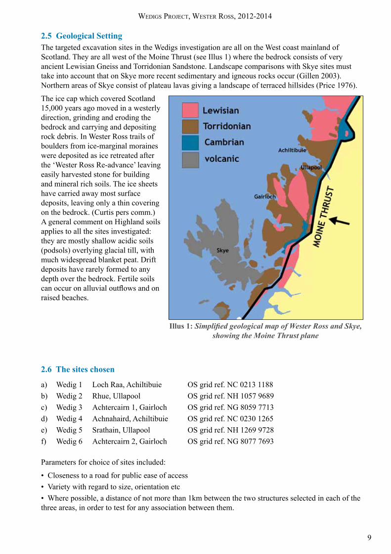
2.5 Geological SettingThe targeted excavation sites in the Wedigs investigation are all on the West coast mainland of Scotland . They are all west of the Moine Thrust (see Illus 1) where the bedrock consists of very ancient Lewisian Gneiss and Torridonian Sandstone . Landscape comparisons with Skye sites must take into account that on Skye more recent sedimentary and igneous rocks occur (Gillen 2003) . Northern areas of Skye consist of plateau lavas giving a landscape of terraced hillsides (Price 1976) .
The ice cap which covered Scotland 15,000 years ago moved in a westerly direction, grinding and eroding the bedrock and carrying and depositing rock debris . In Wester Ross trails of boulders from ice-marginal moraines were deposited as ice retreated after the ‘Wester Ross Re-advance’ leaving easily harvested stone for building and mineral rich soils . The ice sheets have carried away most surface deposits, leaving only a thin covering on the bedrock . (Curtis pers comm .) A general comment on Highland soils applies to all the sites investigated: they are mostly shallow acidic soils (podsols) overlying glacial till, with much widespread blanket peat . Drift deposits have rarely formed to any depth over the bedrock . Fertile soils can occur on alluvial outflows and on raised beaches .
2.6 The sites chosen
a) Wedig 1 Loch Raa, Achiltibuie OS grid ref . NC 0213 1188b) Wedig 2 Rhue, Ullapool OS grid ref . NH 1057 9689c) Wedig 3 Achtercairn 1, Gairloch OS grid ref . NG 8059 7713d) Wedig 4 Achnahaird, Achiltibuie OS grid ref . NC 0230 1265e) Wedig 5 Srathain, Ullapool OS grid ref . NH 1269 9728f) Wedig 6 Achtercairn 2, Gairloch OS grid ref . NG 8077 7693
Parameters for choice of sites included:
• Closeness to a road for public ease of access• Variety with regard to size, orientation etc• Where possible, a distance of not more than 1km between the two structures selected in each of the three areas, in order to test for any association between them .
Illus 1: Simplified geological map of Wester Ross and Skye, showing the Moine Thrust plane
Wedigs Project, Wester ross, 2012-2014
10
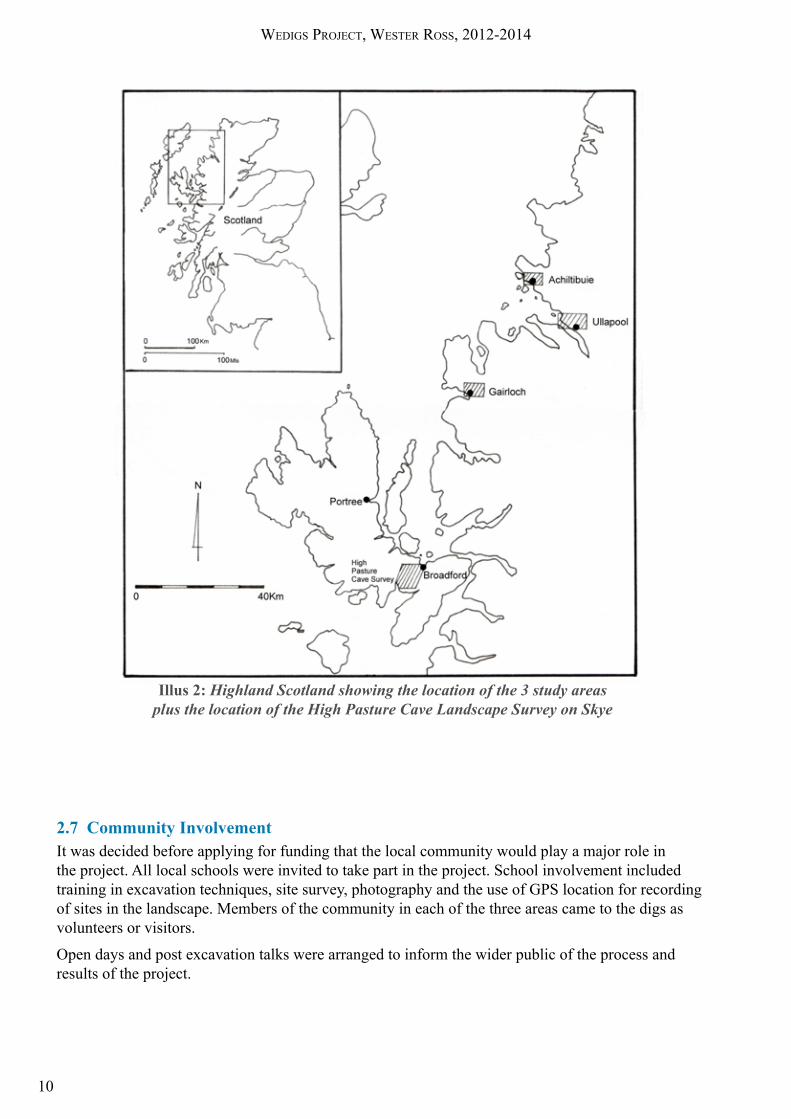
Illus 2: Highland Scotland showing the location of the 3 study areas plus the location of the High Pasture Cave Landscape Survey on Skye
2.7 Community InvolvementIt was decided before applying for funding that the local community would play a major role in the project. All local schools were invited to take part in the project. School involvement included training in excavation techniques, site survey, photography and the use of GPS location for recording of sites in the landscape . Members of the community in each of the three areas came to the digs as volunteers or visitors .
Open days and post excavation talks were arranged to inform the wider public of the process and results of the project.

Wedigs Project, Wester ross, 2012-2014
11
3. The Excavations, listed by study area
3.1 Achiltibuie
Illus 3: Map showing proximity of the two sites investigated near Achiltibuie
3.1.1 Wedig 1, Loch Raa: OS Grid ref . NC0213 1188, HER ref . MHG9126
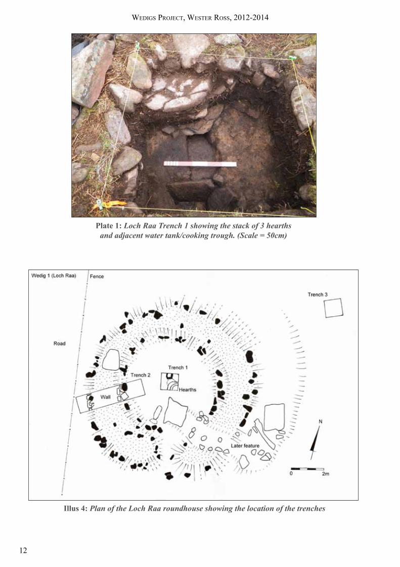
The Loch Raa roundhouse lies close to the eastern shore of the loch, immediately by the eastern side of the road . The remains consist of a rather chaotic, bracken covered circle of boulders and stones some 12m in overall diameter . A possible entrance faces approximately to the south-east . The site lies on a gently sloping hillside which falls away to the loch some 30m to the west . A second, less well defined, roundhouse lies some 40m upslope to the east. The remains of what may be contemporary enclosure boundaries surround the site . Three trenches were excavated, two in the roundhouse and one soil trench close by .
TRENCH 1 was laid out just off the centre of the structure producing a stack of 3 hearths with associated ash and charcoal deposits. The earliest hearth, a shallow pit cut into the natural, with a flat slab at its base, had an associated stone lined tank – a small, well preserved feature – by its north side .
TRENCH 2 was placed across a well preserved section of walling in the south-western arc of the roundhouse . A well built stone wall was revealed some 2m thick, constructed with inner and outer faces . The facing stonework was coursed and well laid, retaining an earth and rubble core . A single post hole complete with packing stones was located 1 .20m in from the inside face of the wall .
There were few small finds other than examples of fragmented pot-boilers, a possible flaked quartz tool and two small fragments of possible soapstone or pottery . A small number of water worn beach pebbles were also recovered .
TRENCH 3 was positioned some 6m to the north of the roundhouse. A well defined sequence of soil horizons was recorded .
Wedigs Project, Wester ross, 2012-2014
12
Plate 1: Loch Raa Trench 1 showing the stack of 3 hearths and adjacent water tank/cooking trough. (Scale = 50cm)
Illus 4: Plan of the Loch Raa roundhouse showing the location of the trenches

Wedigs Project, Wester ross, 2012-2014
13
3.1.2 Wedig 4, Achnahaird (OS Grid ref . NC 0230 1265, HER ref . MHG45594)
The Achnahaird roundhouse lies close to the shore at the southern tidal limit of Achnahaird Bay . It is situated around ½km from the Loch Raa site . The site is surrounded by lazy-bed cultivation ridges and heavily overgrown with bracken . It is on the eastern edge of an unstable dune system which occupies an area of around 6 hectares in and around the bay . The dunes overlie a complex paleo-environment of buried soil horizons (Long 2002) . Latterly the interior of the structure has been used as a feeding stance for livestock. The remains consist of a well defined earth ring-bank with occasional glimpses of stone wall-facing, some 10m in overall diameter . A possible entrance faces to the west . A second, less well preserved roundhouse lies by the shore approximately 150m to the north . The combination of a sheltered bay, freshwater from the Allt Raa flowing into the bay, and extensive dune pasture would have made this area a desirable place to live and farm (Crofts & Mather 1972) .
TRENCH 1 was laid out just off centre and revealed a quadrant of a rubble-stone hearth with much heat reddened stone surrounded by areas of char and ash . The rake-out from the fire spread across a compacted sandy earth floor and formed a well defined occupation horizon . Below this horizon was a layer of clean sand (abandonment) which sealed an earlier, and similar, occupation horizon which lay directly on the levelled summit of a sand dune .
Illus 5: Achnahaird roundhouse showing
trench locations
Plate 2: Achnahaird, detail, rubble stone
hearth in T1

Wedigs Project, Wester ross, 2012-2014
14
TRENCH 2 was placed across a well preserved section of stone wall, revealing an inner face built of laid boulders and slabs and a boulder outer face some 2m to the north . The later phase of occupation butted up to the internal foot of this wall . The earlier phase of occupation ran under the internal face of the wall to butt up to the remains of an earlier wall, consisting of orthostatic facing stones with a rubble fill. The later phase roundhouse wall was built within the earlier phase utilizing the earlier wall in its construction (see Illus .6 below) .
Illus 6: Achnahaird, Trench 2, eastern section, demonstrating the 2 phases of occupation
TRENCH 3. A soil trench outwith the roundhouse amongst lazy-bed cultivation provided a profile of the post-glacial soils and an old ground surface sealed below the lazy-bed cultivation .
Plate 3: Soil Trench T3 dug in a lazybed near to the roundhouse
TRENCH 4 was placed across what appeared to be the west facing entrance to the later phase house . This proved not to be an entrance, but was a recent break in the perimeter allowing animals access to a feeding stance . Excavation revealed a truncated post hole, complete with packing stones, sealed below the later phase wall . The post hole probably belonged to the initial phase of occupation .
Plate 4: Detail of posthole, Achnahaird Trench 4
TRENCH 5 was placed across a related boundary wall which appeared to form an enclosure around the site . No dating evidence was recovered . The wall was shown to have no organized structure, but to be more a linear gathering of boulders and stones from the surrounding landscape .

Wedigs Project, Wester ross, 2012-2014
15
3.2 Ullapool
3.2.1 Wedig 2, Rhue (OS Grid ref . NH 1057 9689)
The Rhue roundhouse lies some 200m up the slope from both the road and a more substantial roundhouse by the roadside (HER ref . MHG7820) . It is about 200m from the sea . The site consists of a heather covered ring-bank some 10m in overall diameter with an extended entrance facing to the south-east . The surrounding area, although heather covered, showed considerable evidence for cultivation with numerous clearance cairns protruding through the peat overburden .
Illus 7: Map showing Srathain and Rhue, showing the proximity of the two settlements
Illus 8: Plan of the Rhue roundhouse showing the location of the trenches

Wedigs Project, Wester ross, 2012-2014
16
TRENCH 1, which was placed just off centre within the structure, revealed a large stone slab set directly on the natural sub-soil . This slab, which had been levelled with stone wedges, showed no indication of heat and was surrounded and part overrun by a black, occupation horizon .
Plate 5: Rhue Central Trench 1 showing a stone slab surrounded by a black horizon
TRENCH 2 was placed across a well preserved section of turf bank just to the west of the extended entrance . Excavation revealed a tumbled stone wall with the inner face surviving 4 courses high . The outer face had tumbled down the slope . The occupation horizon revealed in Trench 1 was seen to butt up to the foot of the inner face of the hut wall .
Illus 9: Rhue Trench 2, west section showing relationship of occupation to in-situ wall
Plate 6: Rhue Trench 2, west section, volunteers exposing the
embankment
TRENCH 3, a soil trench, was placed some 3m to the west of the site .

Wedigs Project, Wester ross, 2012-2014
17
3.2.2 Wedig 5, Srathain 1 & 2 (OS Grid ref . NH 1269 9728)
The Srathain roundhouses are part of a hitherto unrecorded site lying on a steep south facing hillside recently cleared of vegetation by a woodland fire. The site overlooks An Srathan and Allt an t-Srathain running along the floor of the strath. It is 2km up the valley from the Rhue site (see map Illus 7) and the two sites are almost intervisible . The remains consist of three platforms cut into the hillslope at the back and built out at the front . Two of the platforms were trenched .
Srathain 1
Trench 1 placed just off centre within the structure revealed a shallow and very greasy black horizon lying immediately below peaty turf and resting on the local clay natural . There were no features, (other than a small arc of stones), or finds, associated with this horizon. Several small, water worn, white quartz pebbles were associated with the black horizon .
Plate 7: Srathain, west section of central Trench 1 showing shallow
black horizon below the turf
TRENCH 2 was placed on the east side of the circle across what appeared to be the collapsed wall . This proved to be a random pile of stone which overlay the greasy black context and hence post dated it. A random collection of flat slabs lay at the western end of the trench. There were no finds at all. White quartz pebbles were again found in the black horizon .
Two further trenches were excavated:
TRENCH 3: A 1 metre square soil profile trench some 10m to the SW of the platform.
TRENCH 4: A second soil profile trench some 15m to the W of the platform.
The soil profiles of Trenches 3 and 4 almost exactly matched that of Trench 1 with a shallow, greasy, black horizon lying immediately below the turf and directly on the natural .

Wedigs Project, Wester ross, 2012-2014
18
Srathain 2
Srathain 2 lay some 100m to the north and upslope of Srathain 1 and appeared to be identical to it . Trench 5 was excavated from just outwith the front of the platform as far as the centre.
TRENCH 5 demonstrated that the platform had been revetted at the front with a five course wall behind which was a fill of small stones (see Illus 10 and Plate 8) A cut had then been made into the hill slope to create the platform . The greasy black horizon was again present but once again, other than this black horizon, there was no evidence of occupation . At some point after the abandonment of the platform when a layer of peaty soil had formed, a small peat fire had been built at the centre of the platform .
Illus 10: Srathain 2, east section of Trench 5 as in Plate 8
Plate 8: Srathain 2 showing Trench 5
with wall of revetted stones
Wedigs Project, Wester ross, 2012-2014
19
3.3 Gairloch
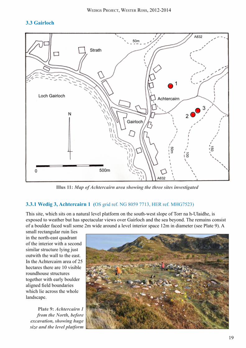
Illus 11: Map of Achtercairn area showing the three sites investigated
3.3.1 Wedig 3, Achtercairn 1 (OS grid ref . NG 8059 7713, HER ref . MHG7523)
This site, which sits on a natural level platform on the south-west slope of Torr na h-Ulaidhe, is exposed to weather but has spectacular views over Gairloch and the sea beyond . The remains consist of a boulder faced wall some 2m wide around a level interior space 12m in diameter (see Plate 9) . A small rectangular ruin lies in the north-east quadrant of the interior with a second similar structure lying just outwith the wall to the east . In the Achtercairn area of 25 hectares there are 10 visible roundhouse structures together with early boulder aligned field boundaries which lie across the whole landscape .
Plate 9: Achtercairn 1 from the North, before
excavation, showing huge size and the level platform

Wedigs Project, Wester ross, 2012-2014
20
TRENCH 1, placed just to the south-east of the centre of the site, revealed 3 levels of activity . Removal of the turf exposed an area of well laid stone slab paving, possibly related to the remains of the small shieling type structure lying immediately to the north of the trench . Sealed beneath this paving was an area of burning so intense that the underlying natural had been reddened to a considerable depth . Closely related stones were also heavily reddened . Removal of the burnt level revealed, in the NE corner of the trench, a shallow scoop in the natural subsoil containing a dark char rich earth and burnt stones .
TRENCH 2, placed across a well preserved section of wall on the southern side of the site, revealed the monumental foundations of a 2 metre wide wall consisting of massive boulder faces with a rubble and soil core. This wall, judging by the amount of collapsed rubble removed, would have stood circa 1 .5m high . Trench 2 extended some 2m inside the wall towards the centre of the site . No occupation surface or evidence of activity was encountered. A single find (a pebble hammer/rubber) was recovered from the rubble fill of the wall .
Plate 11: Achtercairn 1, Trench 2 showing facing stones with wall core removed
TRENCH 3: A 1m square soil profile trench some 10m to the SW of the platform . In addition to samples from T3, a grid based set of soil samples was taken for multi-element analysis .
Illus 12: Achtercairn 1, Plan showing trench
positions
Plate 10: Achtercairn 1: central Trench T1 showing area of intense burning

Wedigs Project, Wester ross, 2012-2014
21
3.3.2 Wedig 6, Achtercairn 2 & 3 (OS grid ref . NG 8077 7693)
These structures were previously unrecorded . This site lies amongst deep heather at the foot of a prominent north-west facing slope . The visible remains of Achtercairn 2 consist of a low heather covered ring bank some 10m in overall diameter with a possible entrance facing to the south-east . A stream runs in the bottom of the valley around 100m away . The site was cleared of heather prior to excavation . A second ring of boulders lies 40m to the north-east . This second site (Achtercairn 3) consists of a ring of boulders which appears to be sitting directly on the surface. This ring is just 6m in overall diameter .
A total of four trenches were excavated: a single trench across Achtercairn 2, two soil trenches and a small test trench T4 within Achtercairn 3 .
TRENCH 1 was placed across Achtercairn 2 on a roughly north to south alignment revealing a fine orthostat faced wall, with a boulder fill, on the north and south sides (see Illus 13). A well built buttress supported the downhill north wall. A compacted clay floor butted up to the inner face of the walls. An oval hearth area (slabs over char filled black earth) lay roughly central to the interior space (see Illus 14). A second hearth, constructed of stone, which post dated the clay floor lay against the inner face of the northern wall. Lifting the clay floor revealed a truncated posthole some 1.25m in from the southern inner wall face . The hole still retained its post pad . A second truncated post hole was found diametrically opposite, 1 .25m inside the northern inner wall face . Removal of the wall stones showed that the stone wall was a secondary feature and that an earth walled roundhouse pre-dated the stone structure (see Illus 14) .
Plate 12: Achtercairn 2 and 3 from hillslope above, showing close proximity
Illus 14: Achtercairn 2 Trench 1; part of West Section showing Phase 1 earth and turf wall, hearth area, and clay floor abutting Phase 2 inner wall

Wedigs Project, Wester ross, 2012-2014
22
TRENCH 2: A 1 metre square soil profile trench some 10m to the NE of the roundhouse.
TRENCH 3: A second soil profile trench some 10m to the W of the roundhouse.
3.3.3 Achtercairn 3
TRENCH 4 was placed within a circular stone setting some 40m down slope of the roundhouse Achtercairn 2 . Excavation showed that the stone setting was not a structured wall but a surface setting of boulders encircling an area of red loamy soil . Within the stone setting was a small cobbled area, which showed no signs of burning, but was associated with well defined areas of charcoal and many chunky quartz fragments .
The dating of charcoal from T4 at Achtercairn 3 gave a surprisingly early date of 2769BC±30, Late Neolithic (see 8.3.2), and so at the beginning of March 2014 the Wedig Project returned to the Achtercairn 3 site .
One question in particular required an answer: “What was the relationship between the dated (C14) Neolithic contexts and the visible remains of the circular structure?”
Illus. 13: Achtercairn 2. Plan and location of Trench 1 showing the second phase structure and the position of the post occupation hearth

Wedigs Project, Wester ross, 2012-2014
23
TRENCHES 5 & 6 were excavated to resolve this problem . A Middle Bronze Age date was obtained from charcoal immediately under the walling .
TRENCH 7, a 1 metre square, was also excavated to recover a recorded series of soil samples for pollen analysis (see Illus 15 for the location of the trenches and Phase 2 contexts) .
The excavations showed that the Phase 1 activity covered a considerable period and was sealed by, and was therefore earlier than, the Phase 2 contexts lying within the circle of boulders . (see Illus 17 for phase 1 contexts and Illus 16 for section A-B demonstrating context relationships) .
Illus 16: Achtercairn 3, Phase 1 a and 1b
Illus 15: Achtercairn 3, Phase 2
Illus 17: Achtercairn 3, T5 section AB
Wedigs Project, Wester ross, 2012-2014
24
4. Summary of micromorphology reports (Lynn Roy, AOC)
Interpretation of the results is presented below by site, sample and layer number from the base up . Each sample covers only 8 x 6 cm of the section .
The matrix of the deposits has been analysed and the results compared with those of wider micromorphological and anthropological studies .
4.1 Micromorphology Analysis for Loch Raa and Achnahaird sites. For the full specialist reports see Appendix 3 .
4.1.1 Loch Raa
Trench T1 (Central)
The Kubiena sample, taken across the boundaries of Contexts 1 .2, 1 .3 showed four distinct micro layers when examined microscopically .
Layer 1 (the lowest examined) is a compact dense sandy silt containing frequent black flecks of micro charcoal . Embedding and compaction probably indicates a trampled hearth .
Layer 2 is unsorted fine sand which has undergone extensive post depositional disturbance. The layer may have been an exposed or neglected domestic space . Iron and manganese accumulations are a possible indication of burial There may have been a burial beneath the overlying hearth . Layer 2 also contains debris material indicating general occupation and incorporating some hearth waste .
Layer 3, a moderately sorted silt, has a clear boundary with underlying Layer 2. It contains fine ash, burned bone fragment, possible burned peat fragments and charcoal fragments all of which indicate domestic hearth waste. The layer has been subject to post depositional disturbance.
Layer 4 is compacted as in Layer 1, and includes mainly fine ash material, indicating a trampled hearth . There is some clustering of coarse mineral and charred matter, perhaps caused by sweeping of hearth waste .
Interpretation
These deposits are a mix which could represent changes of use within the hearth sequence . Possibly the Layer 1 hearth area could have been temporarily abandoned leaving the exposed domestic space of Layer 2 . Layer 4 with compact hearth debris could be interpreted as a change of use of this area, perhaps back into use as a hearth .
Trench T3 (outwith structure)
Two layers were identified, both contained moderately sorted silt with no indicators of anthropogenic activity apart from a few fragments of charcoal which could have blown from the roundhouse a few metres away .
The soil in both layers is typical of a peaty podsol . The question of when the soil podsolisation occurred is interesting in relation to the settlement of the Loch Raa roundhouse . Human impact on an upland soil system is associated with accelerating soil development into a podsol, by formation of peat and by gleying (poor drainage which precedes iron pan formation) . This could have happened before any settlement occurred . The ‘natural’ soil on which the roundhouse was built could have already begun to form a podsol, but any evidence for this podsol formation could be due to compaction of the subsoil under the built structure causing inhibited drainage and leading to formation of iron pan .

Wedigs Project, Wester ross, 2012-2014
25
4.1.2 AchnahairdTrench T1 (Central)
The sample was taken across the boundary of Contexts 1 and 3 and was composed of three micro layers when examined microscopically .
Layer 1 (Lowest examined) is made up of moderately sorted sand with no anthropogenic indications; the layer is probably a windblown deposit which could have sealed an occupation horizon after abandonment .
Layer 2 comprises compact poorly sorted sand which has formed on the windblown sand below . It contains much coarse mineral material and iron stained organic material . This composition would match general occupation and the compaction indicates a floor deposit. It is probably not a hearth deposit as concentrations of charcoal and charred organic material are low . There is an interesting black lens, 1-3mm thick, of amorphous black material and cellular charcoal directly above two partly denuded bone fragments . This is probably indicative of sweeping of hearth waste
Layer 3 has a clear boundary with Layer 2 . It is a compact poorly sorted silt . Phytoliths are common, indicating grass ash and hence agricultural activity . There is a difference in structure between layer 2 and layer 3; both are consistent with compact floor material, but the balance of activities which took place in this area might have altered .
Trench T2 (wall trench)
The sample was taken from the boundaries of three contexts which corresponded to the three layers identified microscopically. Processing of the sample had caused loss of sediment.
Layer 1 is poorly sorted, and is consistent with windblown sand . Iron accumulations indicate that the sediment had undergone soil podsolisation . This could have been caused, or hastened, by the subsequent construction of the roundhouse) .
Layer 2 consists of dark yellowish brown fine organic material. The junction with layer 2 is diffuse probably due to post depositional mixing . Cellular charcoal fragments and patches of calcitic ash are present, indicating human influence. The sediment is relatively compact and represents the first phase of occupation on top of the windblown sand .
Layer 3. This is a poorly sorted sand deposit with significant post-depositional mixing, indicative of exposure and abandonment .
Interpretation
In trench T1 Layer 1 represents a period of abandonment when windblown sand encroached . Layers 2 and 3 indicate occupation, possibly involving different activities .
In T2 the layers indicate an initial surface of windblown sand followed by occupation and subsequent abandonment .
Trench T3 (soil)
T3 was cut into a lazybed cultivation area outwith the structure . The sample was taken across one of two possible buried soil horizons .
The sequence of sediment layers represents a transition from a sandy soil to an organic rich soil horizon, later buried by a reworked sand deposit . The high organic content and extensive bioturbation of Layer 2 may reflect addition of manure. This layer also contains a few carbonized fragments, anthropogogenic indicators .

Wedigs Project, Wester ross, 2012-2014
26
4.2 Micromorphology Analysis for Rhue and Srathain sitesFor the full specialist reports see Appendix 3 .
4.2.1 RhueTrench T1
The sample came from the boundary of two layers within the structure near to a hearth slab .
Layer 1 consists of a mainly organic deposit of highly humified residues which are not burnt, so are not fuel ash. Humification has left limited structural information. The matrix is amorphous yellow clay . Charcoal and wood material appears in weak curled bands, indicating compression . Porosity is low, indicating compaction or trampling of a floor deposit.
Coarse mineral material and rock fragments are mainly absent, unusual for an occupation floor. The charcoal present is not associated with ash so could have been swept into the deposit from nearby .
Layer 2 is also mainly organic . An area near to the top of the layer contains vivianite . This compound forms under reducing conditions where there is an abundance of iron and phosphorus . The source could have been phosphate rich dung or plant matter .
Interpretation
Here the floor deposit, although compacted, did not contain the mix of coarse material which usually indicates occupation . The vivianite in Layer 2 pointed to several possibilities; a stabling deposit, a floor covering, or a turf roof collapse.
4.2.2 SrathainTrench T1
The sample was taken from a possible occupation horizon and consisted of three micro layers .
Layer 1 is unsorted silt loam with large rock fragments and coarse sand-sized minerals . It has been significantly reworked. It contains cellular charcoal. There is an increase in organic material towards the top of the layer .
Layer 2 consists of amorphous black material, together with amorphous reddish brown material . The black material may be disaggregated amorphous charcoal and ash, possibly hearth debris later mixed with plant material . There is little surviving structure with which to identify plants . This layer has been significantly reworked.
Layer 3 is an unsorted silt loam with a structure indicative of a trampled deposit . There is some fragmented charcoal, and microcharcoal in small flecks. This layer has been significantly reworked.
Interpretation
After excavation Srathain was interpreted as an unoccupied platform . However the sample showed evidence of compaction; a layer of anthropogenic amorphous black material was possibly representative of hearth debris . This black material also spread out around and beyond the platform . Further investigation is needed to interpret the usage of this platform .
Wedigs Project, Wester ross, 2012-2014
27
4.3 Micromorphology Analysis for Achtercairn sitesFor the full specialist reports see Appendix 3 .
4.3.1 Achtercairn 1The sample could not be processed .
4.3.2 Achtercairn 2This sample was taken across the boundaries of two contexts inside the roundhouse and three micro layers were identified.
Layer 1 is a compact heterogeneous deposit containing around 50% of coarse sand sized minerals . The mineral component is more varied than in other samples described above . It comprises mainly quartz, but chlorite, biotites and feldspars are also present . Common phytoliths indicate the presence of fine ash and there are flecks of micro charcoal. The structure indicates a trampled deposit. There are few excremental features, perhaps because the low porosity due to compaction precluded penetration of soil fauna .
Layer 2 is also heterogeneous and has a greater proportion of coarse material . There is a weak band of charcoal and grey ash towards the top of the layer; this may represent remnants of hearth clear-out . The structure shows compaction by trampling . There has been much post depositional disturbance, suggesting that this layer had greater exposure to biological, physical and chemical weathering than did Layer 1 .
Layer 3 has a diffuse boundary with Layer 2 . It is a poorly sorted orange/yellow clay with only 10% coarse mineral content . There is little plant tissue and most of the organic matter is disaggregated plant cell material . Phytoliths are evenly distributed . Towards the bottom of the layer is a very small amount of anthropogenic cellular charcoal and grey ashy material. There has been significant reworking of the sediment .
Interpretation
Layers 1 and 2 can be interpreted as trampled material representing accumulation of occupation debris, and layer 3 appears to represent abandonment . Use of space could not be determined due to extensive biological reworking .
4.3.3 Achtercairn 3The sample was taken from T5 across the boundaries of contexts 5 .2 and 5 .3 .
Layer 1 comprises 50% coarse sand sized minerals together with larger metamorphic schist fragments. Identifiable plant tissues are rare, as are cellular charcoals. However at the base of the layer is a small patch of cellular charcoal containing a blackened rock fragment surrounded by reddened sediment . These colorations may have been caused by heat . The layer is thought to be the general remains of occupation or activity, much altered by biological activity .
Layer 2 is an unsorted fine sand with a slight change in mineral composition from Layer 1.There are a few cellular charcoal fragments . At the top of the layer is a cluster of burned material consisting mainly of amorphous black fragments . Organic matter from modern root penetration is present . This layer has been reworked but the contents indicate general occupation or activity incorporating some hearth waste, evidenced by charcoal .
Layer 3 has a higher decomposed organic matter content than the lower layers . Phytoliths and micro charcoal indicate ash and charred material . This layer has seen considerable post- depositional disturbance .
Layer 4 has similar content to layer 2 but has seen significant post-depositional disturbance. There is a charred organic component of sub-angular charcoal fragments . Some fragments from layer 5 are

Wedigs Project, Wester ross, 2012-2014
28
present, possibly having been trampled in from above .
Layer 5 is a compact deposit with massive micro-structure consisting of poorly sorted silts with a coarse mineral component . There are anthropogenic inclusions in the form of burned soil and charred material, consistent with a domestic floor deposit. This layer shows similarities to Layer 1 of Achtercairn 2, interpreted as a trampled floor deposit (see 4.3.2).
Interpretation
Analysis of contexts 5.2 and 5.3 has identified 5 discrete layers which probably represent the accumulation of various activity related debris . Layer 5 may represent a domestic, or at least enclosed, floor surface similar to that seen in thin section from Achtercairn 2. The differences in proportions of coarse mineral material, organic content and anthropogenic inclusions between the 5 layers may indicate the type or intensity of use of the platform .
5. Summary of Multi-element analysis report (Sophie Curran, University of Stirling)
For the full report see Appendix 5 .
The study site was the interior of the roundhouse Gairloch Achtercairn 1 . Auger soil samples were taken on a grid system, to a depth of 20cm . Samples were processed and analysed for 24 elements which were each plotted onto an accurate plan of the roundhouse . Elevated concentrations above background levels were illustrated on the plans . Examples of these element concentrations follow:
The result for phosphorus showed an enhanced central area beside the later sheiling, around the central pit . Also there was a high value around the southern wall section .
Chromium distribution was concentrated around the entrance and the walls . This concentration probably arose from the geology of the wall boulders .
Sodium concentrations are thought to arise from atmospheric deposits .
Boron had similar areas of concentration to those of Chromium .
The whole set of results was analysed using Multivariate Factor Analysis . The resulting graph showed a clustering of samples with similar chemistry . This plot gave no clear anthropogenic signal .
The overall results were inconclusive . There was no indicator of prehistoric usage . Concentrations of phosphorus, iron, magnesium and manganese were probably due to later human and animal use of the sheilings . The auger maximum depth of 20 cm, together with a stony land surface, may have been insufficient to sample prehistoric horizons.
Magnetic susceptibility sampling over several of the sites failed to locate any areas of activity, such as hearths .

Wedigs Project, Wester ross, 2012-2014
29
6. Summary of Pollen Analysis reports (Dr Scott Timpany , ORCA Marine)
For the full reports see Appendix 4 . Samples from Achtercairn 2 and Achtercairn 3 were analysed for pollen .
6.1 Aims of the analysisOn site Achtercairn 2 several bulk soil samples were taken from different contexts in soil trench T3 to retrieve any archaeological and ecofactual evidence for the activities that took place in association with these archaeological features . Kubiena tin (8cm by 5 cm) samples were also taken to provide material for pollen analysis . Samples were analysed from a sequence of two Kubiena tins at Achtercairn 3 and from one tin at Achtercairn 2. The objective was to establish the presence and preservation of pollen grains, to reconstruct the local environment around the time of use of the structures, and to investigate evidence of human-environmental interaction .
6.1.1 Pollen analysisThe methodology is described in detail in the full report, Appendix 4 .
6.1.2 Radiocarbon dating from peat/humic acid A 2g sample of peat was taken at 3cm in the sedimentary sequence in the Kubiena tin sample recovered from Achtercairn 2, Trench 3 . The aim was to date the appearance of cereal pollen in the sequence .
6.2 Achtercairn 2 Trench 3Trench 3 was situated 10m to the West of the roundhouse structure . Two distinct sediment types were recorded in the Kubiena tin sample; Contexts 3 .4 and 3 .3 . Context 3 .4 was the underlying sediment between 6-8cm and consisted of brown peaty silt had inclusions of grey silt and coarse sand, indicating slope wash . Overlying this was Context 3 .3 from 0-6cm, which comprised of dark brown slightly silty peat with visible plant fragments and which again had evidence of slope wash .
The pollen assemblage in Context 3 .4 consisted mainly of shrub and arboreal pollen, 90% of which was from birch and hazel, with smaller percentage values of oak and alder . Evidence of heathland was present from heather pollen, while grassland and open landscape indicators were recorded from grass and other herbaceous pollen . Animal hairs were also recorded from this context in rare occurrences . Microscopic charcoal present suggests burning in the wider area of the roundhouse site .
Context 3 .3 was also dominated by birch and hazel pollen, with a fall in their pollen percentages towards the top of this context . Oak, alder, willow and ivy were also recorded and at the top level of the sequence there is an appearance of pine and elm pollen . Heather pollen increased towards the top of the context as did pollens from grass, sedges, meadowsweet, cinquefoils and saxifrage . Cereal pollen appeared at 3cm, and was continuously present in the overlying levels . In the upper part of this context there is an increase in microscopic charcoal, together with the presence of burnt ground indicators suggesting a rise in burning activity at a local level . Animal hairs were again present in the assemblage with an increased representation from 3cm upwards .
6.3 Achtercairn 3 Trench 7Achtercairn 3 is approximately 40 m downslope from Achtercairn 2 (Illus . 11) . Trench 7 was situated as shown in Illus . 15, within the encircling stone setting . A baulk separated T7 from T5 . Kubiena tin samples were taken from within Trench 7 . The Kubiena tin sequence extended from around 2cm (measured from the top of T7) to 30 cm, and the pollen sequence examined covered 17-27cm . Levels 1-18cm occur in Context 7 .1, (Phase 2) and levels 18-30cm in Context 7 .2, (Phase 1) . Illus . 16 shows a section across T5 indicating these two Phases .
The pollen assemblage in Context 7 .2 changes between 25 and 23cm, indicating a landscape with scrub woodland cover changing to an open heath environment . From 27cm to 25 cm the assemblage consists of arboreal and shrub pollen, consisting mainly of birch, alder and hazel . At 24 cm there is a

Wedigs Project, Wester ross, 2012-2014
30
rise in heather pollen . Herbaceous pollen at this level consists mainly of grass pollen, together with sedges . Cereal pollen is present at 24-23 cm and also at 19cm when barley-type pollen appears . High values of microscopic charcoal occur throughout Context 7 .2; the values decline from 27cm to 23cm, then increase before decreasing again . These high values indicate burning activity within the local and wider area of Achtercairn 3 .
In Context 7 .1 the pollen sequence corresponds to levels 17-18cm . A landscape similar to that shown in Context 7 .2 is indicated, with low values of arboreal pollen and high values of dwarf shrub pollen, especially heather and heaths and herbaceous pollen . There is a slight decline in alder pollen values in Context 7 .2, while there is a slight rise in that of hazel pollen . Ash pollen appears for the first time and pine pollen disappears from the assemblage. Cereal pollen is present with barley-type pollen at 17cm .Microscopic charcoal values are high increasing slightly from the top of Context 7 .2, suggesting that burning took place close to the sampling site .
6.4 Discussion6.4.1 Achtercairn 3The pollen sequence from Achtercairn 3 was sampled mainly from Phase 1 (context 7 .2) sediments, with one level from Phase 2 (context 7 .1) and hence the sequence probably relates to the Late Neolithic to the Early Bronze Age period (for dating see 8 .3 .3) .
The basal (27-25cm) pollen assemblage indicates an open landscape of scrub and wet woodland, together with heath and grassland .
Between 24-23cm there is a decline in overall tree pollen together with a rise in heather pollen and other heath vegetation .
Indicators of disturbance occur from 25-23cm, shown by occurrence of taxa associated with arable land . Barley-type cereal pollen appears at 24cm and 23cm . These disturbance indicators occur at the same sample level as the decline in tree pollen implying deliberate tree felling to create areas for arable farming .
High microscopic charcoal values occur across the whole sequence and these appear to be representative of anthropogenic activity rather than natural causes .
There is evidence for the presence of grazing animals throughout the pollen sequence . From 26 cm upwards dung related spores are present, indicating animal dung .
In summary, it seems likely that arable activity, as well as keeping of livestock, took place from 25cm-17cm in the Achtercairn 3 sequence .
6.4.2 Achtercairn 2Peat at the 3cm level of the Kubiena sample from Trench 3 gave a post-medieval radiocarbon date of 1637± 30 AD (GU 35220) . The pollen sequence does not therefore relate to the archaeology of the roundhouse (see 8 .3 .3 for dates) . However the pollen gives interesting landscape information for this later period .
The overall pollen assemblage shows well established birch-hazel scrub woodland, indicating a recovery from the Middle Bronze Age assemblage of Achtercairn 3 . Oak and alder also had a significant presence. The range of herbaceous pollen types indicate that the scrub woodland would have been quite open. The field layer of the woodland was wet, indicated by herbaceous taxa which grow in wet woodland environments .
At the 3cm level there is a decline in birch and alder pollen, together with a rise in pollen of herbaceous taxa . This is accompanied by a rise in microscopic charcoal, probably with an anthropogenic cause . At this level too are taxa which indicate disturbance, barley-type pollen appears and grass pollen increases slightly .
Wedigs Project, Wester ross, 2012-2014
31
There is some evidence for the presence of grazing animals around Achtercairn 2 throughout the period covered by the Kubiena sample . Animal hairs peaked at the 3cm level, when anthropogenic activity increased . There were no fungal spores associated with dung, but herbaceous taxa linked to grazing were present, as well as nitrophilous taxa including nettles, which can indicate the presence of dung .
A macroscopic assemblage of charcoal fragments recovered from Trench T1 showed the types of wood fuels utilized . These were mainly alder and birch, with smaller amounts of hazel and pine . The predominance of birch charcoal is similar to that indicated by pollens in T3 . In contrast hazel, predominant in the pollens, was rarely used for fuel . Alder, in spite of being scarce in the woodland, was heavily used . Pine, also scarce, was rarely used . Inhabitants of the roundhouse seem to have deliberately chosen not to use hazel .
6.4.3 Conclusions from pollen analysis• Pollen analysis of the Kubiena tin sub-samples has shown that pollen is present in all levels, with pollen preservation being generally good and abundant within the Achtercairn 2 sequence but within the Achtercairn 3 sequence it becomes more degraded and sparse in the lower levels of the sequence, which are less waterlogged than those above .
• The pollen assemblage from Achtercairn 3 corresponds with two phases of archaeological activity. Phase 1 of Early Neolithic date associated with a cobbled surface and burning activity and Phase 2 of Middle Bronze Age date associated with the circular stone ‘wall’ .
• The pollen assemblage from Achtercairn 3 shows that an initial landscape of scrub woodland and grassland with some heath is replaced abruptly by heath and grassland communities following the decline of the woodland .
• The appearance of cereal pollen and high values of microscopic charcoal corresponding with the decline in woodland at Achtercairn 3 suggests deliberate removal of woodland by people for arable activities . Macroscopic charcoal suggests wood from the felled trees was used for fuel .
• The NPP (non-pollen palynomorphs) assemblage for Achtercairn 3 indicates that livestock was also present from the occurrence of dung-related fungi and animal hairs .
• The Achtercairn 2 sequence was dated to the post-medieval period, much later than was expected.
• The pollen assemblage at Achtercairn 2 is dominated by that of birch and hazel, which may be over-represented leading to the masking of more subtle vegetation changes in the landscape and indicates the recovery of woodland in this area following the demise recorded in the Achtercairn 3 sequence .
• Anthropogenic activity is observed in the pollen record from 3cm onwards within the Achtercairn 2 sequence, signalled through an increase in burning activity, some loss of woodland and the appearance of cereal pollen, which indicates the cultivation of hulled barley .
• It is indicated from the pollen studies and the carbon dating that agricultural practices have been taking place in the Achtercairn area from the Neolithic up to Post Medieval . This concept is reinforced by the presence of a network of ancient field walls and probable sheiling structures, bringing the likely practice of agriculture up to the Early Modern period . The 1st edition OS map of the area shows a series of field walls visible in 1820.
Wedigs Project, Wester ross, 2012-2014
32
7. Summaries of reports on the environment at Wedigs Sites
7.1 Environmental evidence from bulk samples (J Robertson AOC)For the full specialist report see Appendix 1 .
Samples were taken from hearths, occupation horizons and pits . Most of the environmental assemblage consisted of charcoal, In addition five poorly preserved bone fragments were found in the Rhue sample.These could not be identified to species.
At Loch Raa species recovered appeared to be from fuel debris; these were alder, birch and hazel .
At Rhue bone fragments were probably resulted from food waste scattered on the floor,
From all the sites the overall charcoal assemblage consisted of 57% birch, 38% alder, 3% hazel, 2% pine .
In the samples taken from probable domestic structures the absence of any charred macroplants and burnt bone is surprising.The floors of these sites may have been regularly swept and refuse disposed of outside the living area .
The composition of wood species probably reflects the composition of the woodland in the surrounding landscapes . Many of the sites are close to a water source, and damp ground would support birch and alder woodland .
The charcoal assemblages from these six sites are typical of findings from other similar sites in Scotland .
7.2 Soils at the Wedigs sites (Professor Bruce Ing) For the full specialist report see Appendix 3 .
Samples were taken from the soil pits outside each roundhouse. Soil horizons were identified by colour and texture differences from neighbouring layers, and a sample was taken from each horizon . The samples were air dried . In the laboratory each sample was tested by loss on ignition for organic content, and, with a Hanna pH meter, for pH, electrical conductivity and total dissolved solids .
Results summarized were as follows:
Loch Raa: the soil appeared to be a peaty gleyed podsol typical of upland areas of high rainfall . The top layer was humified with minerals leaching down into layers derived from the underlying till. The bottom layer of loamy sand lies over a more impervious bed, accounting for the accumulation of minerals here .Micromorphological analysis of a Kubiena sample from Trench T3, outwith the structure, indicates that pre-occupation podsols have been compacted, accelerating podsolisation and iron-pan formation .
Achnahaird: The profile suggests that there have been major changes in the site during occupation and subsequently . The basal layer probably represents the original sand dune system on which a soil developed which was then covered by a later soil development . There were marked differences in nutrient levels in the different layers, probably due to the impact of agriculture . The dune sand in the lowest layer may indicate enrichment with calcium from marine shells . Results from the micromorphology analysis indicate a possible second phase of dune building .
Rhue: The overall appearance is of a thick layer of acid peat overlying sandy boulder clay . The upper layers are affected by current vegetation and grazing . There is limited leaching to the lower layers .There is a striking difference between the soil pit layers in T3, outwith the structure, and the micromorphology of the sample from T1 within . This indicates the impact of human and livestock disturbance on soil content and structure .
Srathain: The top layer consisted of peaty topsoil, overlying a layer of sandy loam containing much organic matter . This overlay a greasy black loamy sand, rich in nutrients, and the lowest layer was

Wedigs Project, Wester ross, 2012-2014
33
gritty sand, low in nutrients . Interpretation of these samples was confusing . The soil seems to have been greatly altered during and after activity on the site .
Gairloch Achtercairn 1: This is a typical peaty soil with gleying in the lower portions . Flecks of charcoal are visible in the second layer, suggesting burning activity in the nearby structure . Each layer is highly organic . The study by Curran (2013) showed characteristic chemical indicators of human activity; there were enhanced levels of many elements within and adjacent to the structure.
Gairloch Achtercairn 2: The upper three layers are peat deposits with nutrient levels increasing with depth . The organic content gradually decreases with depth . The lowest layer, a brownish grey clay, is possibly a buried podsol . It has a low organic content, possibly because organic materials have become trapped in the layers above. The clay bottom is impeding drainage. The profile may be incomplete as the trench could have been deeper .
Comments
The soils investigated were what would be expected from a region covered in blanket peat overlying glacial till. These soil profiles indicate how the land surface may have been altered by early cultivation and by grazing animals .

Wedigs Project, Wester ross, 2012-2014
34
8. Interpretation of the roundhouse structures and usage in each of the three areas, considering wall structure, features uncovered by digging, C14 dates, small finds, micromorphological reports, and, for Achtercairn sites, pollen analysis.
C14 dating has shed light on occupation and re-occupation, and whether all structures in a group of roundhouses can be regarded as contemporary . (for details of C14 dates see Appendix 7)
Small finds have been sparse.
8.1 Achiltibuie Area
8.1.1. Loch Raa (see 3 .1 .1 above)
StructureThe Loch Raa structure consisted of coursed well laid double skin walls, with a rubble and earth core, around a central hearth area . The structure has an overall diameter of around 12m . The stone slab tank, probably used for cooking, was set alongside the earliest hearth . At least two further hearths were constructed above the first with related occupation debris. This had accumulated to a depth of around 300mm, indicating occupation over a considerable time .It was noticeable that the structure was well drained; the inner trenches were dry when heavy rain caused the soil trench to flood. It is likely that there was an upslope ditch to remove the hill water, but this was not investigated .The single posthole found 1 .20m inside the inner wall might have supported roof timbers, although it was perhaps too close to the wall for this purpose . Alternatively the posthole could be evidence of an internal partition .
Dating (see Appendix 7 for details)The earliest hearth gave a C14 date of 3207±27 BP (GU30612) . This is 1257±27 BC, Early Bronze Age, and the most recent hearth in the stack was dated at 2374±27 BP (GU30611) . This is 424±27 BC, Early Iron Age . The two dates and the hearth stack indicate at least eight centuries of occupation, probably spasmodic, with the same central hearth area being reused over time . For this to be possible the footings of the original roundhouse must have been clearly visible when any new occupants took up residence . No sign was found at Loch Raa of repair or rebuild although only a small part of the structure was sampled .
Micromorphology interpretation (see summary 4 .1 .1) T1The sample is 8cm by 6cm so the analysis only refers to this small section across the boundary of Contexts 1.2 and 1.3. Four layers were identified, indicating a trampled hearth area at the top (layer 4); below this layer 3 was disturbed domestic hearth waste; layer 2 was a neglected domestic space which may have housed a burial; and layer 1 was a trampled hearth . Hence over this small section there are indications of change of use from an initial occupation in layer 1, to abandonment and exposure, then re-occupation in layer 4 . This reinforces the interpretations from dating and the stack of hearths, but gives much more detailed information .The sample from T2 shows the same pattern of occupation and abandonment .
Finds Several cracked pot boilers were found in association with the hearth area . This gives credence to the usage of the slab tank beside the hearth for cooking .A small fragment of pottery was found in context 2 .1 against the inner wall face . This was a reworked rim fragment from a shouldered vessel made from steatite-rich clay or heavily tempered steatite pottery (see Appendix 6, Archive Catalogue Loch Raa LR05, also Illus 18a) . The vessel may have had a minimum diameter of 160mm at the rim . Similar steatite tempered and shouldered vessels are

Wedigs Project, Wester ross, 2012-2014
35
known from Kebister, Shetland, (Dalland & MacSween 1999), where they have been dated to Early Iron Age (see Appendix 6 for expert interpretation) . This gives credence to the Early Iron Age date from the most recent hearth .A further expert opinion on this pottery fragment indicated doubt that it was part of a rim .
Illus 18a: Pottery fragment
A rim sherd from a small Steatite vessel was also recovered close to the above pottery sherd . It appeared to come from a small rounded cup or crucible (see Appendix 6 Archive Catalogue Loch Raa LR08, also Illus 18b) . The external surface is rounded . The rim is damaged but the diameter could have been around 60mm .
A further expert opinion on this steatite sherd indicated doubt that it was part of a rim .
Illus 18b: Steatite fragment
These were the only examples of pottery found across all the digs . The fragments were found in the same context as the latest hearth, and their possible styling reinforces the Early Iron Age dating .
A translucent grey quartz flake was found in the same context as the earliest hearth, indicating that it was probably struck during the Early Bronze Age occupation .
Wedigs Project, Wester ross, 2012-2014
36
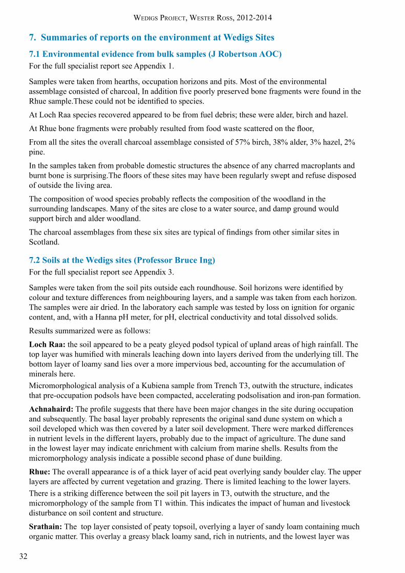
8.1.2. Achnahaird (see 3 .1 .2 above)
StructureThe structure at Achnahaird is situated in the dunes on the south-east shore of Achnahaird Bay, less than 1km from the Loch Raa site (see Illus 3) . The site started life as a double skinned walled structure faced with orthostats and filled with rubble. This initial roundhouse was around 10m in overall diameter with a wall 1 metre thick . After a period of abandonment a 2nd phase wall was built inside the 1st phase inner wall, reducing the interior diameter from 8 .0 to around 5 .5m .The inner face of the 2nd phase wall was built of coursed stonework . The position of the door opening was unclear .There were two well defined occupation horizons .The phase 1 floor level abutted the phase 1 inner wall face (see Illus 6) .In the 2nd phase a centrally placed hearth on a compacted sand floor was surrounded by a charcoal rich occupation horizon abutting the 2nd phase inner wall face . A single post hole located underneath the 2nd phase wall was 1 .6m inside the inner face of the phase 1 wall . It may have been one of a ring of posts supporting the original roof trusses .
DatingA C14 date of 2345±29 BP (GU30613) was obtained from the occupation horizon inside the 2nd phase wall . This is 395±29 BC, Early Iron Age . There was no dating evidence for Phase 1 .
Micromorphology interpretation (see summary 4 .1 .2)T1The sample taken included the boundary between Contexts 1 .1 and 1 .3 and consisted of three layers . Layer 1 was a deposit of windblown sand, which may have sealed an earlier occupation horizon after abandonment. Layer 2 included hearth sweepings and seemed to be a compacted floor deposit. Layer 3 had a different structure but was also compacted . It contained phytoliths from grass ash indicative of agricultural activity outside the house . The differing structures of layers 2 and 3 indicate a change in activities taking place inside the house .T2The sample was taken at a deep level in the trench . It crossed the boundaries of contexts 2 .9, 2 .8, 2 .10, including the phase 1 occupation layer . Layer 1 consisted of windblown sand with evidence of soil podsolisation, perhaps caused by the construction of the initial roundhouse . Layer 2 was compacted organic material. This is probably the floor of the phase 1 occupation. Layer 3 indicated exposure and hence subsequent abandonment . These samples were damaged during processing, but the information obtained was sufficient to confirm the interpretation made on site during excavation.
FindsSeveral potboilers were found and some stone tools (see Appendix 6, Archive Catalogue Achnahaird for details of contexts). Most of the tools came from the stone wall fill, are consistent with an Iron Age date and indicate earlier activity on or close to the site .
8.1.3 Links between Loch Raa and Achnahaird sitesThe Achnahaird date of 395±29 BC matches the latest occupation date from Loch Raa, 424±27 BC . It is probable that the two roundhouses were occupied at the same time around 400 BC . The early Loch Raa date (1257±27 BC) indicates that the roundhouse seems to have been occupied, possibly spasmodically, for around 800 years . It is probable that during some of these occupation periods the Achnahaird site in its Phase 1 stage was also occupied .
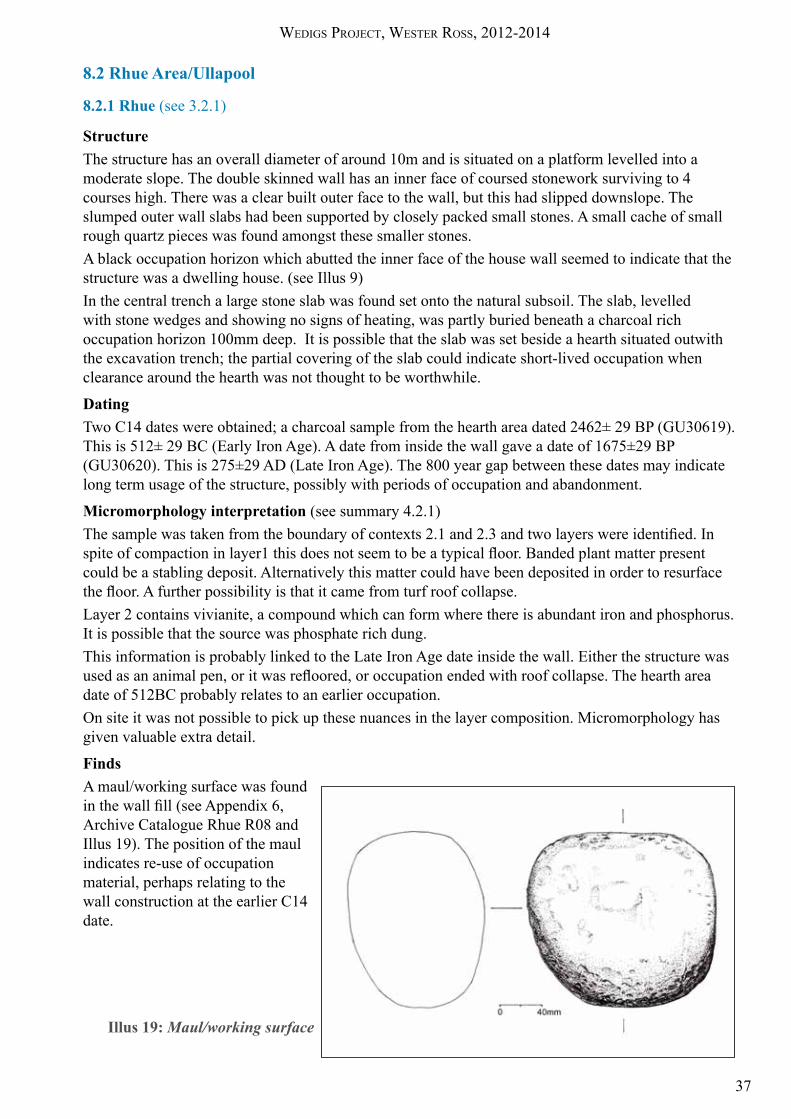
Wedigs Project, Wester ross, 2012-2014
37
8.2 Rhue Area/Ullapool
8.2.1 Rhue (see 3 .2 .1)
StructureThe structure has an overall diameter of around 10m and is situated on a platform levelled into a moderate slope . The double skinned wall has an inner face of coursed stonework surviving to 4 courses high . There was a clear built outer face to the wall, but this had slipped downslope . The slumped outer wall slabs had been supported by closely packed small stones . A small cache of small rough quartz pieces was found amongst these smaller stones .A black occupation horizon which abutted the inner face of the house wall seemed to indicate that the structure was a dwelling house . (see Illus 9)In the central trench a large stone slab was found set onto the natural subsoil . The slab, levelled with stone wedges and showing no signs of heating, was partly buried beneath a charcoal rich occupation horizon 100mm deep . It is possible that the slab was set beside a hearth situated outwith the excavation trench; the partial covering of the slab could indicate short-lived occupation when clearance around the hearth was not thought to be worthwhile .
DatingTwo C14 dates were obtained; a charcoal sample from the hearth area dated 2462± 29 BP (GU30619) . This is 512± 29 BC (Early Iron Age) . A date from inside the wall gave a date of 1675±29 BP (GU30620) . This is 275±29 AD (Late Iron Age) . The 800 year gap between these dates may indicate long term usage of the structure, possibly with periods of occupation and abandonment .
Micromorphology interpretation (see summary 4 .2 .1)The sample was taken from the boundary of contexts 2.1 and 2.3 and two layers were identified. In spite of compaction in layer1 this does not seem to be a typical floor. Banded plant matter present could be a stabling deposit . Alternatively this matter could have been deposited in order to resurface the floor. A further possibility is that it came from turf roof collapse.Layer 2 contains vivianite, a compound which can form where there is abundant iron and phosphorus . It is possible that the source was phosphate rich dung .This information is probably linked to the Late Iron Age date inside the wall . Either the structure was used as an animal pen, or it was refloored, or occupation ended with roof collapse. The hearth area date of 512BC probably relates to an earlier occupation .On site it was not possible to pick up these nuances in the layer composition . Micromorphology has given valuable extra detail .
FindsA maul/working surface was found in the wall fill (see Appendix 6, Archive Catalogue Rhue R08 and Illus 19) . The position of the maul indicates re-use of occupation material, perhaps relating to the wall construction at the earlier C14 date .
Illus 19: Maul/working surface

Wedigs Project, Wester ross, 2012-2014
38
8.2.2 Srathain (see 3 .2 .2)
StructureTwo of the three revetted platforms cut into a steep hillslope were investigated . Wall structure was absent apart from platform revetment at Srathain 2 . The outer wall of the revetment consisted of 5 courses of stonework behind which was a rubble fill. The platform of Srathain 1 was encircled by a rubble bank .The only horizon of any interest was a thick layer of greasy black soil which was present on both platforms . In the case of Srathain 1 this black layer pre-dated the encircling band of rubble . The soil trenches at Srathain 1 also demonstrated that the black layer was present around the platform for a considerable distance . This greasy black horizon may indicate activity on and around the sites, but is not evidence of occupation .
DatingA C14 date of 2479±27 BP (GU30618), was obtained from a soil sample inside the structure Strathain1 .This is 529±27 BC, Early Iron Age .
Micromorphology interpretation (see summary 4 .2 .2)The sample was taken from the horizon of greasy black soil in Srathain 1 . Three micro layers were identified and they showed the development of an anthropogenic sediment with charcoal appearing in all layers . This information, coupled with the excavated evidence, suggests that Srathain 1 may have been a charcoal burner’s platform .
FindsThree waterworn quartz pebbles and three small quartz flakes were found in the rubble bank.
8.2.3 Links between Rhue and Srathain sitesThe early date from Rhue (512±29 BC) matches the date obtained from the Srathain site 2km upstream (529±27BC) (see Illus 7 for map) . This indicates that phase 1 occupation of the Rhue site coincided with activity at the Srathain site .
There is a clear sight line from the Srathain platforms down the valley to the Rhue site and the sea . The Rhue site is set amongst clearance cairns and old field walls which could have ancient origins, an indication of agricultural activity . Modern dwelling houses at Rhue are situated on good sheep grazing land between the Rhue roundhouse and the sea . It is probable that other prehistoric dwellings would have made use of this land . No evidence remains apart from a bronze axehead found on a stone slab (since buried under concrete) ½ km from the Rhue site, and a series of stone slabs with associated cavities at a distance of 1km from the site at the end of the Rhue peninsula .
The Rhue roundhouse is near to the mouth of Allt an t-Srathain, and to the sea. Hence fishing would have taken place as well as agriculture . In contrast, the Srathain site, consisting of three recessed platforms, is on a very steep hillside, 2km from the sea, and grazing or cultivation areas are limited . The Srathain type of site would be categorized in Argyll as an unenclosed recessed platform settlement, sometimes interpreted as the work-place of charcoal burners . Recent work (Jobey 1981 and Rennie 1997) however has shown that some of these recessed platform sites include prehistoric roundhouses amongst their numbers . It is possible that wooden huts were built on the platforms at Srathain, but no evidence of this was found . There seemed to be no structure in the wall builds there apart from the platform revetments . It is possible that the platforms, having been used for charcoal burning, were, as the late hearth on Srathain 2 shows, subsequently re-used as sites for temporary dwelling to enable summer grazing, in the same way as later sheilings were used .

Wedigs Project, Wester ross, 2012-2014
39
8.3 Achtercairn area, Gairloch
8.3.1 Achtercairn 1 (see 3 .3 .1)The structure was built on a massive scale, outer diameter being 17 .5m . This was a greater size than that of any of the other 9 circular structures surveyed in the Achtercairn area . The orthostat boulders forming the wall faces are huge, and, from the amount of collapsed tumble, the wall may have stood 1 .5m high . The entrance to this structure was around 2 .5m wide, unusually wide for a roundhouse, and was in the SW, whereas most of the visible entrances recorded for other roundhouses in Wester Ross are in the SE, (Welti A . 2011) .The slabs found under the turf in trench 1 seemed to be associated with the sheiling remains, possibly forming a paved surface . The area of reddened soil under these slabs had considerable depth and indicated great heat intensity . The earlier scoop containing charred soil and burnt stones indicates an earlier hearth . There was no occupation surface either around the burnt area in Trench 1 or inside the wall in Trench 2 . Hence the structure was probably not a dwelling . It could have been a workshop, although no sign of metal working was found . It might have been a ceremonial centre; it would have been an imposing structure in the landscape . The stones used in the walls, probably selected with care from the surrounding terrain, were massive and geologically varied; grey-green Amphibolite, reddish brown Torridonian Sandstone, and white Gneiss .The evidence of intense burning could indicate fierce fires lit to form a beacon. The idea of a ceremonial use gains credence from the fact that in Dec 2012, from a position in the centre of the circle, the mid-winter sun (21st Dec solstice) set exactly in line with the centre of the door opening and also with a v-shape in the silhouette of the Skye mountains seen across the sea .
DatingCharcoal from the char filled scoop and heat reddened area gave C14 dates of 2204±29 BP (GU30615), and 2163±27 BP (GU30614) . These dates are 254±27 BC and 213±29 BC . They indicate a fairly short period in the Middle Iron Age during which burning took place .
Micromorphology interpretationThe sample taken was unable to be processed .
FindsA fire-cracked pounder was found in the wall fill (Appendix 6 Archive Catalogue G07). This position perhaps indicates the presence of an earlier site close by .
8.3.2 Achtercairn 2 (see 3 .3 .2)
The Achtercairn 2 enclosure started life as an earth banked roundhouse (see Illus 14) . The two postholes identified inside the N and S inner walls indicate a ring of posts some 1.25m inside the bank possibly supporting a ring beam as part of the roof structure . This earth bank (phase 1) was then upgraded to an orthostat faced stone walled roundhouse (phase 2), a new clay floor was inserted (sealing the earlier post holes) and a central hearth was cut into the clay . No postholes were found within the trench for this secondary structure . At some point after the abandonment of the stone-built house a hearth was built against the inner face of the north wall of the house . The position of this late feature, abutting the North wall, and hence very close to any sloping roof, indicates that there was probably no longer a roof on the roundhouse when the hearth was in use .
Dates
Charcoal from the central hearth associated with the later stone walled house gave a C14 date of 2676±29 BP (GU30616) . This is 726±29 BC, Late Bronze Age . A date from Trench 3 (soil) was peat/humic acid dated at 313±30 BP (GU35220) . This is 1637±30 AD, Late Medieval .
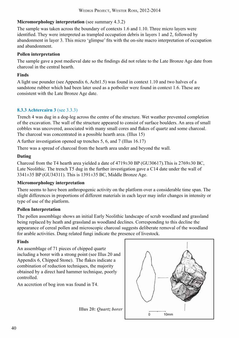
Wedigs Project, Wester ross, 2012-2014
40
Micromorphology interpretation (see summary 4 .3 .2)The sample was taken across the boundary of contexts 1 .6 and 1 .10 . Three micro layers were identified. They were interpreted as trampled occupation debris in layers 1 and 2, followed by abandonment in layer 3. This micro ‘glimpse’ fits with the on-site macro interpretation of occupation and abandonment .
Pollen interpretationThe sample gave a post medieval date so the findings did not relate to the Late Bronze Age date from charcoal in the central hearth .
FindsA light use pounder (see Appendix 6, Acht1 .5) was found in context 1 .10 and two halves of a sandstone rubber which had been later used as a potboiler were found in context 1 .6 . These are consistent with the Late Bronze Age date .
8.3.3 Achtercairn 3 (see 3 .3 .3)Trench 4 was dug in a dog-leg across the centre of the structure . Wet weather prevented completion of the excavation . The wall of the structure appeared to consist of surface boulders . An area of small cobbles was uncovered, associated with many small cores and flakes of quartz and some charcoal. The charcoal was concentrated in a possible hearth area . (Illus 15)A further investigation opened up trenches 5, 6, and 7 (Illus 16 .17)There was a spread of charcoal from the hearth area under and beyond the wall .
DatingCharcoal from the T4 hearth area yielded a date of 4719±30 BP (GU30617) .This is 2769±30 BC, Late Neolithic . The trench T5 dug in the further investigation gave a C14 date under the wall of 3341±35 BP (GU34311) . This is 1391±35 BC, Middle Bronze Age .
Micromorphology interpretationThere seems to have been anthropogenic activity on the platform over a considerable time span . The slight differences in proportions of different materials in each layer may infer changes in intensity or type of use of the platform .
Pollen Interpretation The pollen assemblage shows an initial Early Neolithic landscape of scrub woodland and grassland being replaced by heath and grassland as woodland declines . Corresponding to this decline the appearance of cereal pollen and microscopic charcoal suggests deliberate removal of the woodland for arable activities . Dung related fungi indicate the presence of livestock .
FindsAn assemblage of 71 pieces of chipped quartz including a borer with a strong point (see Illus 20 and Appendix 6, Chipped Stone). The flakes indicate a combination of reduction techniques, the majority obtained by a direct hard hammer technique, poorly controlled .An accretion of bog iron was found in T4 .
Illus 20: Quartz borer

Wedigs Project, Wester ross, 2012-2014
41
In North Scotland lithic assemblages are mainly of quartz, and the majority of these date to Neolithic or Early Bronze Age (Engl, Appendix 6). This fits with the Late Neolithic date obtained from charcoal in T4 in association with the assemblage .
During the further investigation more quartz chips and cores were found . A partially completed saddle quern was found in an insecure context in T7 .
The phase 1a occupation of the terrace can therefore be shown to consist of an initial hearth with related cobbled area and charcoal spreads (Illus 17) . The preparation of quartz cores and struck blades (see Appendix 6) was probably associated with this period of activity . After the initial Neolithic activity it is possible that the site was abandoned and then re-occupied in the Middle Bronze Age, (phase 1b) . Subsequently a rather loose circle of boulders was constructed on the terrace . The site may have been cleared and levelled prior to this further re-occupation (phase 2) . Centrally placed within the boulder circle was a small area of laid cobbles within a boulder kerb, and many pieces of charcoal (Illus 15) .
It is possible that Achtercairn 2 was associated with the phase 2 platform of Achtercairn 3 in the Bronze Age . Achtercairn 2 had a Late Bronze Age date for the phase 2 build, but no date was obtained for the earlier phase 1 earth ring bank . It may be noteworthy that the Achtercairn 3 Layer 5 thin morphological section showed a similar compact floor to that in Achtercairn 2 Layer 1.
8.3.4 Links between the three sites at AchtercairnEach structure investigated had a very different date and function . There are 10 roundhouse structures in the Achtercairn area and three were excavated (see Illus 11 .) Comparing these three, there seemed to be no clear overlap in occupation dates .
Achtercairn 1, probably not a dwelling, may have been used as a ceremonial site in the Mid Iron Age .
At Achtercairn 2, the initial structure consisted of an earth ring bank which was replaced in the Late Bronze Age by a stone built structure . There was no evidence of later occupation to coincide with activity at Achtercairn 1 .
The Late Neolithic date for Achtercairn 3 matches the estimate of the quartz assemblage date . This implies that people were working quartz on the flat platform area in the Neolithic.
The Achtercairn 3 ‘under-wall’ C14 date of 1391± 35 BC, Middle Bronze Age, evidences further activity on the platform at that time, before the encircling boulders were put in place . This Middle Bronze Age activity may have been linked to the earth ring banked Phase 1 roundhouse at Achtercairn 2, but lack of dating evidence renders this speculative .
The Neolithic and Middle Bronze Age contexts of Achtercairn 3 were sealed by, and hence earlier than, the undated context containing the circle of boulders (Illus 16, section A-B demonstrates context relationships) .
Pollen analysis of samples taken from test pits near Achtercairn 2 and on the platform of Achtercairn 3 has given a detailed interpretation of the surrounding landscape and the effect which probable anthropogenic agricultural activities had on the flora, both in post medieval times and in the Late Neolithic/Early Bronze Age .
Wedigs Project, Wester ross, 2012-2014
42
9. Comparisons with the targeted excavations of circular structures in the landscape around High Pasture Cave on Skye (Birch, & Wildgoose, forthcoming)
9.1 Wall StructureDuring the Wedigs excavations 11 structures (8 circular structures and 3 revetted platforms) on 6 sites were investigated. From initial field survey all were thought to be roundhouses. Excavation demonstrated that only 6 were occupied roundhouses . The remaining 5 showed no evidence of occupation; 3 were revetted platforms of uncertain use and 2 were circular structures also of uncertain use . It can be seen from the list below that there is a close correlation between walled structures and occupation .During the excavations 3 wall types and 2 other types of structure were identified as follows: (1) Three structures had double skin orthostat walls: • Achtercairn 1 No evidence for occupation – possible ritual site • The phase 1 structure at Achnahaird Evidence of occupation • The phase 2 structure at Achtercairn 2 Evidence of occupation
(2) Three structures had walls faced with coursed stonework: • Loch Raa Evidence of occupation • Rhue Evidence of occupation • The phase 2 structure at Achnahaird Evidence of occupation
(3) One structure had a turf built wall: • Achtercairn 2 phase 1 Evidence of occupation
(4) There were three boulder revetted platforms: • Srathain 1 No structure—work area • Srathain 2 No structure—work area • Achtercairn 3 Phase 1 No structure—work area
(5) One structure was a loose circle of boulders: • Achtercairn 3 Phase 2 No structure—work area
Of the 7 walled structures only one (Achtercairn 1) produced no occupation evidence . The revetted platforms and the phase 2 terrace of Achtercairn 3 showed no evidence for standing walls and might be considered as working areas . Achtercairn 1, due to its size, construction and position, stands apart from the other 10 sites excavated . It is very large and has a massive boulder orthostat enclosure wall with an overly wide entrance way which faces to the south west over falling ground . The interior produced no evidence for use or occupation apart from the central area of burnt reddened soil, an indicator of intense heat . This has proved a site difficult to categorise.
In the High Pasture Cave landscape 29 circular structures were test pitted . The same three wall types were identified, with a further type being a rubble bank which might have originally been orthostat faced . The greatest number were double skinned orthostat faced walls . There were a few structures faced with built walling, several rubble walls, and a very few turf walls . There were several boulder revetted positive platforms on fairly steep slopes . These had no stone wall structure, but, as in Wedigs, might have originally supported wooden structures .
The mix of wall types between structures in Wester Ross and Skye is similar .

Wedigs Project, Wester ross, 2012-2014
43
9.2 Entrance orientationEntrances in the Wedigs excavations were discernible in four of the structures: • At Loch Raa, Rhue and Phase 2 Achtercairn 2 the entrances faced SE or S. We could not tell where the entrance was situated in Achtercairn 2 phase 1 or in Achnahaird phases 1 and 2 .• Achtercairn 1 had a wide entrance facing SW.The structures with SE or S entrances showed evidence of occupation . There was no occupation evidence for Achtercairn 1, and its entrance directly faced the midwinter solstice sunset .
In the High Pasture Cave landscape, where entrances were visible, those with entrances close to SE all had evidence of occupation, while those with other orientations had no such evidence . Although the Wedigs numbers are small the general result is similar .
9.3 HearthsThese were found as follows in the Wedigs excavations:• Loch Raa: stack of 3 hearths, the earliest one being a stone slab at the base of a shallow pit in the natural . • Achnahaird: 1 hearth set on clean windblown sand.• Rhue: 1 hearth consisting of a stone slab on the natural ground surface.• Achtercairn 1: 2 hearths, one a thick layer of intensely burned soil, one an earlier scoop in the natural ground surface .• Achtercairn 2: 2 hearths, the later one unusually against a side wall.• Achtercairn 3: 1 hearth in a scooped pit.• Srathain 2: 1 small hearth, fired once, after abandonment of site.
In the High Pasture Cave structures only 1 hearth was found on each site with proven occupation . This was interpreted as evidence of brief occupation or of keeping the floors well swept. 11 of these hearths were slabs laid on the natural and 4 were pit hearths .
Here the two areas show differences . The presence of more than one hearth indicates occupation and reoccupation . The High Pasture Cave structures do not seem to have had the obvious longevity of most of the occupied Wedigs structures .
9.4 Post holesThese were found in the Wedigs excavations at:• Loch Raa, complete with packing stones, 1.2m in from the inner wall face. • Achnahaird, complete with packing stones, under the Phase 2 walling, so associated with the Phase 1 occupation .• Achtercairn 2, two postholes, one 1.25m from inner face of south wall, and one directly opposite, 1 .25m from inner face of N wall . The S posthole retained its post pad .
These post holes may have been part of a ring of posts supporting roof beams, or they may have acted as supports for radial partitions .
In the High Pasture Cave circular structures there were postholes at only 3 sites . The lower percentage of sites with postholes is probably due to the random nature of the positions of the wall trenches . Here also these holes were interpreted as roof beam or partition supports .

Wedigs Project, Wester ross, 2012-2014
44
9.5 FindsSmall finds from the Wedigs sites consisted mainly of broken pot boilers and some stone tools. Many of these tools came from the wall fills, indicating earlier activity in the general area. At Achtercairn 3 an assemblage of chipped quartz flakes and cores was found, with one borer. Pottery was absent apart from two small fragments at Loch Raa, probably parts of small vessels . One of these was carved steatite and one was steatite rich pottery .The Wedigs structures, like the High Pasture Cave sites, produced many broken pot-boilers . However the Wedigs sites produced only 2 vessel sherds compared to 103 from the High Pasture Cave sites . Despite the difference in number of sites tested this disparity is significant, perhaps relating to a difference in material culture between the two areas .
9.6 DatingC14 dates were obtained for Wedigs structures as follows:Achiltibuie area• Loch Raa Early Bronze Age, Middle Iron Age• Achnahaird Middle Iron AgeUllapool area• Rhue Early Iron Age, Late Iron Age• Srathain Early Iron AgeGairloch area• Achtercairn 1 Middle Iron Age• Achtercairn 2 Late Bronze Age• Achtercairn 3 Late Neolithic, Middle Bronze Age
A late medieval to post medieval date was obtained from peat/humic acid in the Kubiena sample taken outwith the structure of Achtercairn 2, in the soil trench T2 . This later date probably relates to medieval farming in the area . The surrounding landscape has evidence of this with many ruined enclosure walls and some house footings, indicating agricultural usage over a long period of time .
The High Pasture Cave sites produced dates ranging from the Early Bronze Age to the middle of the 19th Century . An initial assumption had been that the 29 structures may have existed in a stable prehistoric landscape . However analysis of the dates showed that at any one period of time only 2 or 3, and at the most 4, structures were occupied . Hence only a few families at any one time would have occupied the area. The majority of the High Pasture Cave survey roundhouses were dated to the Bronze and Iron Ages, as were the Wedigs structures .
9.7 Occupation horizonsExtended occupation sequences in the Wedigs excavations were found at Loch Raa, Achnahaird, Rhue, and Achtercairn 2 . From micromorphology analysis it seems likely that occupation was occasional and not continuous .
In the High Pasture Cave circular structures there was little or no build up of floor deposits. This might indicate either a short term or occasional occupation, or possibly a rigorous house cleaning regime .
9.8 Conclusions from comparisons with High Pasture Cave Landscape.In both sets of excavations the initial appearance of the ring banks in the landscape appeared to indicate similar roundhouse forms . However all were different, in structure, in size and in dating . These variations matched in the two study areas. Differences in the build-up of floor deposits could indicate differing occupation sequences between Wester Ross and Skye . An interesting difference was the quantity of high quality black burnished ware pottery found in Skye, since the only examples found in Wester Ross were two tiny fragments; one of coarse steatite rich pottery and one of steatite .

Wedigs Project, Wester ross, 2012-2014
45
10. Discussion arising from evidence of occupation and abandonment
Evidence about Neolithic and Bronze Age settlement patterns in the North and West of Scotland has come from excavations mentioned in the Introduction 2 .2 . Taking one of these as an example, at Acheny Glen the investigations provide a detailed study of a Scottish upland landscape . Hut circles there were mainly dated to Middle Bronze Age settlement, where people were living on land worked already in the late Neolithic and Early Bronze Age . Earlier settlement evidence had been buried or damaged by subsequent cultivation . Prior to this work at Acheny Glen, hut circle groups had often been interpreted as long term settlements under continuous occupation for many hundreds of years . At Acheny Glen paleo-environmental evidence indicated continuity of land use . However very few of the excavated hut circles showed evidence of long term occupation . (McCullagh & Tipping 1998) .
Long sequences of occupation have been shown to be a series of short occupations followed by abandonments (Halliday 1999), and it is possible that these occupations may have lasted for less than a generation, followed by long periods of disuse . Prehistoric farming was not as we, who are used to a landscape of fields and fences, might imagine it. Cereal cultivation would have taken place in small cleared areas close to the house, and grazing could be more wide ranging in cleared woodland . Abandoned sites with surrounding cereal planting areas would be used as pasture and for hunting, and then after a gap, perhaps of a few generations, the abandoned sites would be re-occupied and re-cultivated .
Hence the continuity is not in the individual hut circle settlements but in the whole landscape . This would have involved a dynamic system of land use throughout the Bronze Age . Movement would have taken place both in short annual cycles around structures in a settlement, and also in long term cycles as the original settlement was moved to different sites (Halliday 2007 & Halliday unpub) .
This cyclical pattern can be seen in the results from the High Pasture Cave landscape survey and may be inferred in the Wester Ross results from the dating and occupation sequences . The ‘brief glimpse’ of occupation and abandonment shown by the micromorphological analysis of a tiny section of the trench horizons inside the structures has shown that there were many more changes over time than can be easily discerned with the naked eye . Pollen analysis is also crucial in understanding the detailed changes in the landscape over time .
No occupied roundhouses appeared to show single period use . Occupation and abandonment were shown by the structures:• at Rhue, which yielded two dates 800 years apart, and which showed interesting floor interpretations,• at Loch Raa, with a stack of hearths and dates also 800 years apart,• at Achtercairn 2 where a second roundhouse had been built on top of the first,• at Achtercairn 3, although interpretation is unclear, there is evidence of activity on the site over a long time period,• at Achnahaird where the later roundhouse was built on top of and within the first.
A similarity occurs at Cul a Bhaile, Jura, where an excavated hut circle was found to be completely rebuilt on the same site, inside the original house (Stevenson 1984) . As with the Achnahaird structure, the Cul a Bhaile internal diameter diminished as the walling was rebuilt .

Wedigs Project, Wester ross, 2012-2014
46
11. Final commentsThe aims of the project were to investigate two sites in each of three areas of Wester Ross, Achiltibuie, Ullapool and Achtercairn, and:• to examine site and wall typology,• to establish dating of structure usage and abandonment,• to reconstruct surrounding landscapes,• to look at factors governing site choice.
Standard archaeological methodology has yielded considerable information on structure . Sections from the trenches inside each structure gave information about phases of occupation .
Dating was mainly obtained from charcoal samples, since pottery, often datable typologically, was not found at 5 out of the 6 sites investigated . One humic acid date was obtained from the Kubiena sample taken in soil trench T2 at Achtercairn 2 .
Finds overall were sparse, and few were found in the occupation deposits . This may in part be due to their deterioration in the soil over such a long period, but may also be because of frequent floor sweeping . At High Pasture Cave there were large deposits of midden material near to the cave and in the associated roundhouses there was hardly any build up of floor deposits. It is possible that floors were swept and the material deposited as a ritual at the cave site (Wildgoose pers . comm .) . This may also apply to the Wester Ross roundhouses, although, since no middens were found, there is no evidence as to where the floor deposits might have been taken.
Micromorphology has been shown in this study to be an important technique for identifying the soils’ micro-scale structural properties which cannot be seen at the macro-scale . This has enabled a better understanding of the depositional formation processes and hence to an informed interpretation of activities and usage, and of occupation and abandonment .
Pollen analysis at both Achtercairn 2 and Achtercairn 3 has given a detailed and intricate view of the changes in the surrounding landscape over time .
Overall the project has produced a useful amount of information about prehistoric dwellings in an area where little excavation has previously taken place . It has shown that, in spite of limitation of sample numbers due to budget constraints, micromorphological and pollen analysis has great interpretative value . It has also shown the breadth and depth of information that can be gathered from a series of targeted test pits/trenches in these structures which had, from initial field survey, appeared similar .
Wedigs Project, Wester ross, 2012-2014
47
12. ReferencesAnderson J . 1896 ‘Note on a bronze sword found at Inverbroom, Ross-shire’, Proceedings of the Society of Antiquaries of Scotland, 30, 352-6 .
Armit I . 1990 (ed) ‘Beyond the Brochs, changing perspectives on the later Iron Age in Atlantic Scotland’, Edinburgh University Press .
Armit I . 1991, ‘The Atlantic Scottish Iron Age: Five levels of chronology’ Proceedings of the Society of Antiquaries of Scotland, 121, 181-214 .
Armit I . 1992, ‘Excavations at Cnip, sites 2 & 3, Lewis, 1989’, Proceedings of the Society of Antiquaries of Scotland, 122, 137-148 .
Armit I . 1994, ‘Archaeological Field Survey of the Bhaltos peninsula, Lewis’ . Proceedings of the Society of Antiquaries of Scotland, 124, 67-93 .
Armit I . 1996, ‘The Archaeology of Skye and the Western Isles’, Edinburgh University Press .
Armit I . 1998, ‘Re-excavation of an Iron Age Wheelhouse and earlier structure at Eilean Maleit, North Uist’, Proceedings of the Society of Antiquaries of Scotland, 128, 255-271 .
Armit I . 2006, ‘Anatomy of an Iron Age Roundhouse’, Society of Antiquaries of Scotland/Historic Scotland .
Barber J & Brown M .M . 1984, ‘An Sithean, Islay’ . Proceedings of the Society of Antiquaries of Scotland 114,161-188 .
Barber J . (ed) 1997, ‘The Archaeological Investigation of a Pre-historic Landscape: Excavations on Arran 1978-1981’ Scottish Trust for Archaeological Research .
Barber J . 2003, ‘Bronze Age Farms and Iron Age farm mounds of the Outer Hebrides’, SAIR 3 .
Birch, S . & Wildgoose, M . ‘Uamh an Ard Achadh (High Pasture cave) and Environs Project. Landscape Evaluation 2006 – 2010’. (DSR forthcoming)
Brown A . G .2008, ‘The Bronze Age Climate and environment of Britain’, Bronze Age Review (Vol 1, 7-21) British Museum .
Bunting M .J . & Tipping R . 1997, ‘Palynological investigations at Badentarbat, Achiltibuie, Highland Region: the temporal context of medieval or post-medieval cultivation practice’, Unpublished supplemental report, University of Stirling.
Cavers G . 2010, ‘Crannogs and Later Prehistoric Settlement in Western Scotland’, BAR510.
Cook M . & Dunbar L . 2008, ‘Rituals, Roundhouses and Romans Volume 1’, Scottish Trust for Archaeological Research, Edinburgh .
Crofts R . & Mather A . 1972, ‘Beaches of Wester Ross’, Countryside Commission of Scotland and Aberdeen .
Curle A .O . 1910, ‘Examination of two hut circles in the Strath of Kildonan, Sutherlandshire, one of which has an Earth House annexed’, Proceedings of the Society of Antiquaries of Scotland, 45, 18-26 .
Dark P. 2006, ‘Climate deterioration and land-use change in the first millennium BC: perspectives from the British palynological record’ . Journal of Archaeological Science 33, 1381-1395 .
Dalland M . & MacSween A . 1999,’The coarse pottery’ in Owen O . & Lowe C . Kebister . The four-thousand-year-old story of one Shetland township,178-9 .Edinburgh: Soc Antiq Scot (Monograph Ser No 14) .
Fairhurst H . & Taylor D .B . 1971, ‘A Hut circle at Kilphedir, Sutherland’, Proceedings of the Society of Antiquaries of Scotland, 103, 65-103 .

Wedigs Project, Wester ross, 2012-2014
48
Gillen C . 2003, ‘Geology and Landscapes of Scotland’, University of Edinburgh .
Halliday S .P . ‘Bronze Age Settlement in Mainland Scotland’, unpub .
Halliday S .P .1999, ‘Hut Circle Settlements in the Scottish Landscape’, Northern Archaeology 17/18, 49-65 .
Halliday S .P . 2007, ‘Unenclosed roundhouses in Scotland: occupation, abandonment, and the character of settlement’, in Burgess C ., Topping C . and Lynch F . (eds) Beyond Stonehenge: Essays on the Bronze Age in honour of Colin Burgess . Oxford, 49-56 .
Harris J . 1984, ‘A preliminary survey of hut circles and field systems in S E Perthshire, Proceedings of the Society of Antiquaries of Scotland’, 114, 199-216 .
Hingley R . 1992 ‘Society in Scotland from 700BC to AD 200’ . Proceedings of the Society of Antiquaries of Scotland, 122, 7-53 .
Hingley R . et al 1997, ‘The Excavation of two later Iron Age fortified homesteads at Aldclune, Blair Atholl, Perth and Kinross’, Proceedings of the Society of Antiquaries of Scotland 127, 40-66 .
Hunter J . R . 1996, ‘Fair Isle, The Archaeology of an Island Community’, HMSO Edinburgh .
Jobey, G . 1981: ‘Green Knowe Unenclosed Platform and Harehope Cairn, Peebleshire’ . PSAS 110, pp72-113 .
Long A . 2002 , ‘Achnahaird Sands, Coigach, Wester Ross’, M . Litt Thesis, Glasgow University, (unpublished) .
MacKie E . W . 1963, ‘A dwelling site of the earlier Iron Age at Balevullin, Tiree’, Proceedings of the Society of Antiquaries of Scotland, 86,155-183 .
MacKie E .W 2002, ‘The Roundhouses, Brochs and Wheelhouses of Atlantic Scotland, Part 1’, BAR 342, Basingstoke Press .
MacKie E .W 2007, ‘The Roundhouses, Brochs and Wheelhouses of Atlantic Scotland. Part 2’, BAR 444 (l), BAR 444 (ll) .
MacKie E .W . 2000, ‘Excavations at Dun Ardtreck, Skye in 1964, 1965’ . Proceedings of the Society of Antiquaries of Scotland, 130, 301-411 .
MacLaren A . et al 2003, ‘A Later Prehistoric house and early Medieval buildings in Northern Scotland, Excavations at Loch Shurrery and Lambsdale Leans, Caithness, 1955’ . SAIR 5 .
Maxwell G .S . 1967, ‘Excavations at Drumcarrow, Fife: an Iron Age unenclosed settlement’, Proceedings of the Society of Antiquaries of Scotland, 100, 100-108 .
McCullagh R .P .J . & Tipping R . (eds) 1998, ‘The Lairg Project 1988-1996, The Evolution of an Archaeological Landscape in Northern Scotland’, The Scottish Trust for Archaeological Research Edinburgh, Monograph 3 .
Mercer R . J . 1996, The excavation of a succession of prehistoric round-houses at Cnoc Stanger, Reay, Caithness, 1981-2, Proceedings of the Society of Antiquaries of Scotland, 126, 157-189 .
Milek K .B . 2006, Houses and Households in Early Icelandic Society, Geoarchaeology and the Interpretation of Social Space, Dissertation for the degree of Doctor of Philosophy, Newnham College, University of Cambridge (unpub) .
O’Sullivan A . 1997, Interpreting the Archaeology of Late Bronze Age Lake Settlements, Journal of Irish Archaeology vii .
Owen O and Lowe C 1999, Kebister, ‘The 400 year old story of one Shetland Township’, Society of Antiquaries of Scotland, Monograph 14 .

Wedigs Project, Wester ross, 2012-2014
49
Parker Pearson M . et al 2005, ‘The Prehistoric Village at Cladh Hallan- Part 1’ http://www .shef .ac .uk/archaeology/research/cladh-hallan
Parker Pearson M . et al, 2004 ‘South Uist, Archaeology and History of a Hebridean Island’, Tempus, Stroud .
Peacham R .W . 1960, ‘Unenclosed Platform Settlements’, Proceedings of the Society of Antiquaries of Scotland, 93, 174-191 .
Pope R . 2003, ‘Prehistoric Dwelling, Circular Structures in North and Central Britain c 2500BC-AD500’, PhD Thesis, University of Durham.
Price R .J . 1976, ‘Highland Landforms’, Highlands and Islands Development Board, Inverness .
Prior F . 1998, ‘Farmers in Prehistoric Britain’, Tempus, Stroud .
RCHAMS, 1997, ‘Achiltibuie; the Archaeology of a Crofting Landscape’. RCAHMS Broadsheet 3 . Royal Commission on Ancient and Historical Monuments of Scotland, Edinburgh .
Rees T . & Mills C . 1999, ‘Bracken and Archaeology’, Historic Scotland, Edinburgh .
Rennie B, 1997 . ‘The Recessed Platforms of Argyll, Bute and Inverness’ . BAR 253, Tempus Reparatum .
Rideout J .S . 1995, ‘Carn Dubh, Moulin, Perthshire: survey and excavation of an archaeological landscape 1987-90’. Proceedings of the Society of Antiquaries of Scotland, 125, 139-195 .
Romankiewicz T . 2011, ‘The Complex Roundhouses of the Scottish Iron Age, Vols 1 & 2’, BAR 550, 1&2 .
Stevenson J . B . 1984, ‘The excavation of a hut circle at Cul a Bhaile, Jura’, Proceedings of the Society of Antiquaries of Scotland, 114, 127-16 .
Tipping R . et al 2008, ‘Response to Late Bronze Age climate change of farming communities in North East Scotland’. Journal of Archaeological Science 35, 2379-2386 .
Welsh T .C . ‘Survey of Glen Achall, Rhidorroch, Wester Ross‘ (unpublished) .
Wildgoose M et al, 1999, ‘Cille Mhaire Basin, Isle of Skye, an archaeological Survey of a Relict Landscape’, John Muir Trust, unpublished .
Wildgoose M . 1999, ‘A survey of Round Houses on the Strathaird, Torrin and Sconser Estates’, John Muir Trust (unpublished) .
Wildgoose M and Birch S 2003, ‘Kingsburgh Common Grazings, Woodland Grant Scheme Proposal’, Archaeological Survey (unpublished) .
Welti, A . (2011), ‘Prehistoric Round House Structures in Wester Ross, and in Selected Areas of Skye’. Undergraduate Dissertation unpublished, University of Aberdeen .
Wildgoose M . and Welti A . 2013, ‘Wedig Project 2012: A Study of West Coast Circular Structures Through Landscape Survey, Site Survey and Excavation’. Unpublished Data Structure Report .
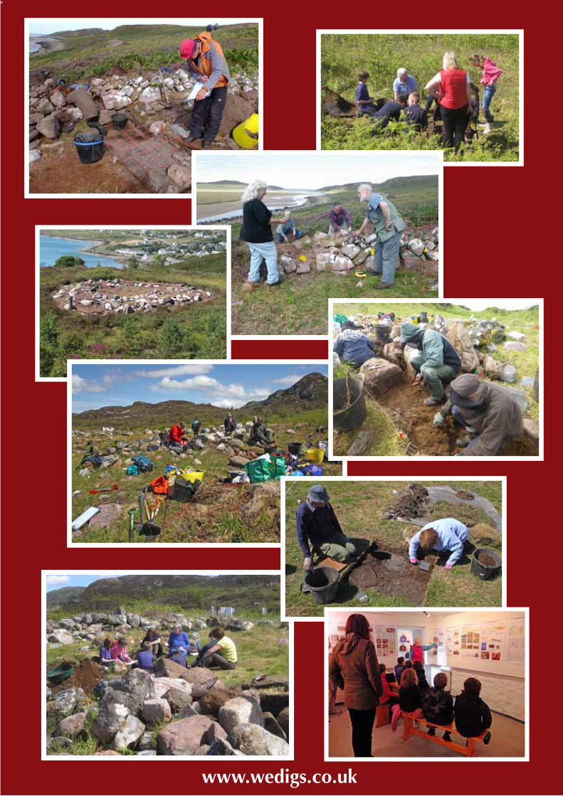
Wedigs Project, Wester ross, 2012-2014
50
Wedigs Project 2012-2014
FINAL REPORTAuthors
ANNA WELTI and MARTIN WILDGOOSE
Funded byHeritage Lottery Fund, The Highland Council,Lochbroom Field Club, NOSAS,Mr & Mrs P Rex, Drs B & M Dumughn
A Study of West Coast Circular Structures
through Landscape Survey, Site Surveyand Excavation
A Community Archaeological Project
www.wedigs.co.uk