final report of british renland expedition 2016 (mef ref ... expeditions... · final report of...
TRANSCRIPT

British Renland Expedition 2016
Page 1
Final Report of British Renland Expedition 2016 (MEF Ref 16-25)
Overview In an exploratory climbing expedition Geoff Hornby, David Barlow, Robert Powell, Paul Seabrook
travelled to unexplored/unnamed glacier near Mirror Wall area of South Renland from 18 July-19
Aug 2016 and climbed four new routes including first ascents of two alpine peaks in various styles.
The rock quality varied, with all rock routes featuring both excellent and crumbly biscuit granite. This
trip demonstrated the huge potential for exploratory alpinism in this remote area.
First Ascents Summary – Key Achievements One 10 pitch Rock climb “Arctic Monkeys” approx. 400m UK E2 5b, UIAA VI-/VI.
One Alpine Style Ridge SouthEast Ridge Cerro Castillito UIAA V / Alpine AD+/D- 1300m
Altitude gain, 2000m Glacier Approach, 600m snow Ice Gully, 590m Alpine Ridge.
This was the first ascent of Cerro Castillito.
One Alpine Snow Ice Gully "Double 00 Couloir", Mount Hannes, Alpine AD, 800m.
One Alpine Arête "Polar Daze", Mount Hannes, 20 Pitches, approx. 1400m climbing Alpine
TD- / TD.
This was the first ascent of Mount Hannes.
Background Following an initial visit and report in 2013 by Michael Raab and Betsy Winston (see AAJ report here
http://publications.americanalpineclub.org/articles/13201212215/Renland-Various-Ascents) , Geoff
Hornby organised a team and planned to visit this region of Greenland to further explore the
opportunities for alpine climbing and multi pitch rock climbing in the glaciated valleys south of the
Mirror Wall / Edwards Baily Glacier in the SW Corner of Renland, positioned at the NE end of the
huge Scoresbysund fjord in East Greenland.
The team comprised Geoff Hornby (Leader/Organiser, UK) David Barlow (UK) , Robert Powell (RSA &
UK) and Paul Seabrook (UK). Following an initial supply trek to ABC, Geoff sustained a knee injury
and had to withdraw from further active involvement in the expedition, being evacuated from the
beach base camp by Inuit boat and returning early to the UK.
All images in this report are small versions of the attached full size images.
First Ascent – “Arctic Monkeys” 400m E2, 5b 26th July 2016 – Barlow/Powell/Seabrook alt leads

British Renland Expedition 2016
Page 2
10 pitch Rock climb Arctic Monkeys approx. 400m UK E2 5b, UIAA VI-/VI. Pitches with UK
grades:
o 1) 10m 4c - Cross the snow patch with crevasses and start on the middle of three
cracks, then traverse right to the rightmost crack under an overhang. This crack is
followed for the next 3 pitches.
o 2) 50m 5b - Overlap to start then follow the crack up slabbier ground with some
loose blocks.
o 3) 45m 5b - Follow the crack past lots of big scary looking flakes and quite steep with
an offwidth section at the top.
o 4) 65m 5b - Nice jam crack with perfect hands and laybacking.
o 5) 35m 5a - Head right to avoid some big bad roofs via some zigzagging ramps and
cracks to escape right via a slot under the roof on biscuity rock.
o 6) 10m 4c - Short traverse to the right under the roof with some friction slab
climbing and a mantle onto a grassy ledge.
o 7) 55m 5b (crux)- Sketchy start on loose looking rock. Start up a groove past a peg
(we placed and removed it) to move leftwards onto a slab, continue leftwards to the
corner and upwards to reach a slab on the left. Head leftwards for 15m (no
protection) towards a corner and just before the corner head up a rampline leading
to the upper section of the corner and make a hanging belay.
o 8) 40m 5a - Continue up the corner to a slab with flaky / snappy rock. Head up
towards the roof and flank the roof on the right wall by pulling outwards onto the
arête and then the slab, climb up the steep slab/wall to a crack and continue to a
leftwards overhanging crack with jammed blocks (great climbing - best on the
route).
o 9) 45m 4c - Head up diagonally leftwards and then horizontally leftwards to reach
twin cracks breaking through a little overlap and then loose climbing to the summit
ridge.
o 10) 35m - Easy climbing up loose and chossy ground to reach a comfortable grassy
platform on the right of the ridgeline.
The route finished on reaching the ridgeline of the mountain which was a logical finishing
point.
Descent by 5 rock abseils down the other side of the col, then scrambling down to the
glacier.
GPS Location and altitude
o Start 885m 71°10'37.48"N 25°48'9.30"W
o Top 1114m 71°10'39.39"N 25°48'20.28"W

British Renland Expedition 2016
Page 3
Topo photo "Arctic Monkeys Topo.jpg"

British Renland Expedition 2016
Page 4
Location photo "Arctic Monkeys (IMG_0621_topo).jpg" showing dotted descent

British Renland Expedition 2016
Page 5
Action Photo "Arctic Monkeys pitch 8 (IMG_3082).jpg"
First Ascent SE Ridge Cerro Castillito AD+/D- 1300m 29th July 2016 – Barlow/Powell/Seabrook alt leads
Alpine Style Ridge (SouthEast Ridge Cerro Castillito UIAA V / Alpine AD+ / D- 1300m Altitude
gain, 2000m Glacier Approach, 600m snow Ice Gully, 590m Alpine Ridge.
Climb the snow gully to the col, then along the ridge mainly on the left, passing a shoulder
snow patch along the way. The ridge reaches a sub-summit from where a 30m abseil leads
to a small col. A further 10m traverse rightwards followed by a 50m pitch leads to the true

British Renland Expedition 2016
Page 6
summit. There are possible bivi spots on the ridge but we climbed it in a 24 hour push from
ABC.
This was the first ascent of the mountain.
This route was attempted by Michael Raab and Betsy Winston in 2012 but they retreated at
a col partway along the ridge.
Descent by rock abseils close to the ascent line (re-climbing the 30m sub-summit abseil via
an easy crack), then abalakov anchors and down climbing the snow gully.
GPS Location and altitude
o Start 969m 71°11'28.15"N 25°43'0.61"W
o Col 1400m 71°11'45.84"N 25°42'23.58"W
o Summit 1715m 71°11'50.63"N 25°42'51.01"W

British Renland Expedition 2016
Page 7
Topo Photo "Cerro Castillitio (IMG_0765_crop_route1).jpg" from ABC to Summit

British Renland Expedition 2016
Page 8
Summit photo "Cerro Castillitio Summit (P1000081).jpg"

British Renland Expedition 2016
Page 9
Action photo "Cerro Castillitio action photo (IMG_0500).jpg"
First Ascent “Double 00 Couloir” AD 800m 1st August 2016 – Barlow/Powell/Seabrook alt leads
Alpine Snow Ice Gully ( Double 00 Couloir , Mount Hannes ) Alpine AD 800m, initially 55°
rising to 75° at the col.
British Renland Expedition 2016
Page 10
Descent by one initial rock abseil, then abalakov anchors down the ascent line, with a few
rock abseils towards the end.
GPS Location and altitude
o Start 684m 71°10'9.70"N 25°45'27.98"W
o Col finish 1148m 71° 9'49.20"N 25°45'17.79"W

British Renland Expedition 2016
Page 11
Topo Photo "Double 00 Couloir topo (IMG_7728_topo).jpg"

British Renland Expedition 2016
Page 12
Double 00 Couloir close up "Double 00 Couloir (IMG_0566).jpg"

British Renland Expedition 2016
Page 13
Action Photo " Double 00 Couloir David Barlow (IMG_0603).jpg "

British Renland Expedition 2016
Page 14
First Ascent “Polar Daze” NE Arête “Mount Hannes” 1400m TD 6th & 7th August 2016 with a bivi on a ledge partway up. There was no water or snow on the
route until the descent couloir.
Alpine Arête 20 Pitches, approx. 1400m climbing Alpine TD- / TD (E2 5b).
Our rack consisted of 1 set of micro cams, 2 sets of Camalots to #3, 1 x #4 Camalot, 1 set of
Nuts, some pegs (2 placed on the abseils) and 2 ice screws (for glacier travel).
We carried a satellite phone.
We did not carry or place any bolts.
This was the first ascent of the mountain. We discussed the naming beforehand and all
team members agreed to name the Mountain “Mount Hannes” after Rob’s climbing partner,
Hannes Esterhuyse, who tragically passed away whilst climbing in the Alps when he pulled
off a massive loose block. We have since notified the family and Hannes’s entire family is
very happy about the naming. Hannes’s parents are said to be especially happy with this
memorial to their son.
Descent from the W end of the summit ridge by 5 rock abseils to reach the Double 00
Couloir ~25m down, then many abalakov anchors down the couloir, with a few rock abseils
towards the end.
GPS Location and altitude
o Start 684m 71°10'9.70"N 25°45'27.98"W
o Bivi 1172m 71°10'0.56"N 25°44'56.80"W
o Summit 1330m 71° 9'50.78"N 25°45'8.30"W

British Renland Expedition 2016
Page 15
Topo photo " Polar Daze topo (IMG_0451_topo).jpg"
Location photo " Mount Hannes showing Polar Daze and Double 00 Couloir (IMG_7729).jpg"
British Renland Expedition 2016
Page 16
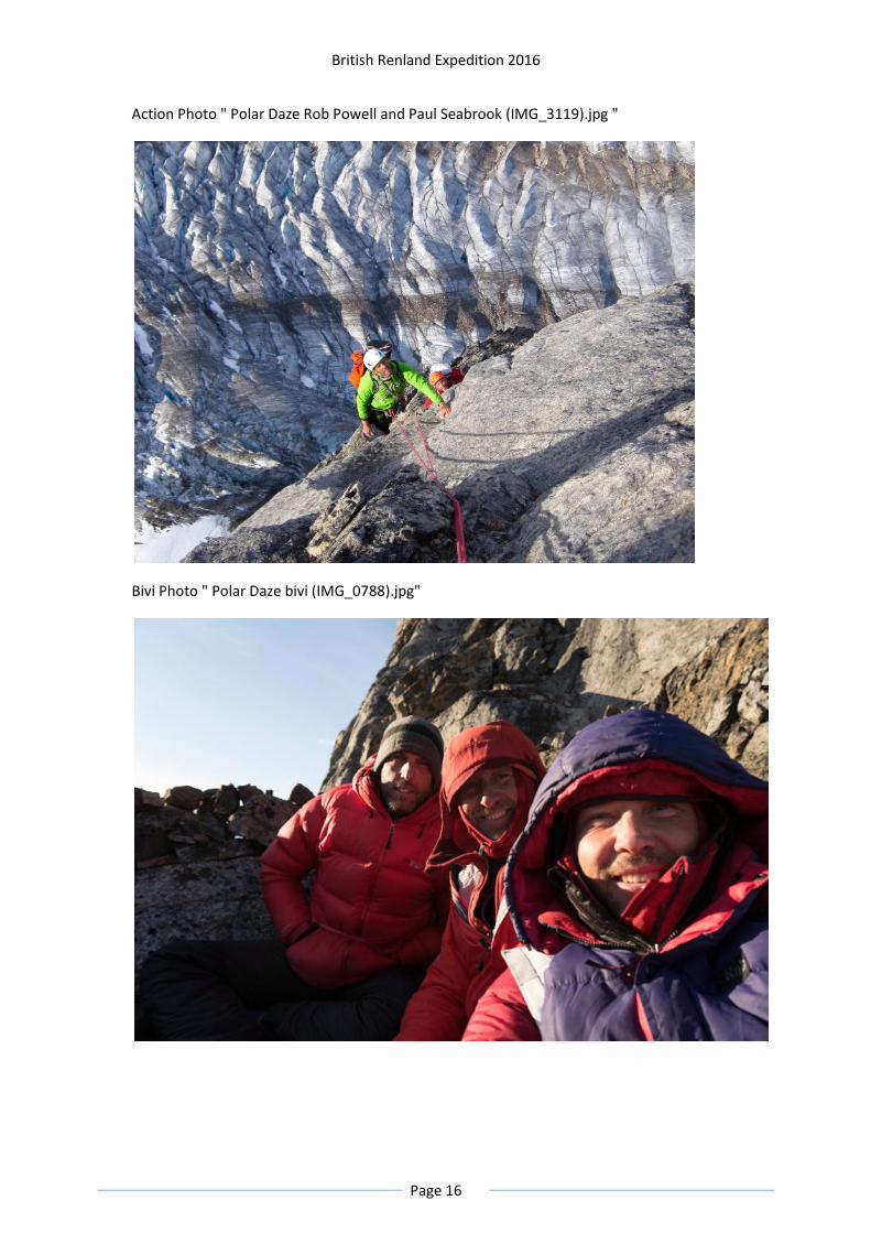
Action Photo " Polar Daze Rob Powell and Paul Seabrook (IMG_3119).jpg "
Bivi Photo " Polar Daze bivi (IMG_0788).jpg"

British Renland Expedition 2016
Page 17
Summit Photo "Polar Daze summit (IMG_0826).jpg"
The Esterhuyse Family after hearing the news of Mount Hannes

British Renland Expedition 2016
Page 18
Action photo "Polar Daze Rob Powell (IMG_0738).jpg"

British Renland Expedition 2016
Page 19

British Renland Expedition 2016
Page 20
Summary and Info/Logistics/Facts Logistics were organised by Tangent Expeditions www.climbgreenland.com. In addition to transport,
Tangent provided white gas, polar bear protection (rifle, flares, trip wire, etc), satellite phones, air &
sea band radios, a Personal locator beacon and helicopter flares. The team flew from the UK to
Rekyavik, Iceland, drove to Akureyi in North. Iceland then flew onto Constable Point in East
Greenland, with 180Kg of food and equipment shipped out beforehand in 60 litre blue barrels (from
http://www.dvcontainers.co.uk/product.asp?pid=70). Excess luggage charges on the Greenland leg
are ~£3/Kg, and the airport generally do weigh hand and hold luggage (the planes are quite small).
A rather unpleasant overnight (to avoid anabatic winds) 12 hour 215Km RIB journey followed from
Constable Point to the boat drop off point. We strongly recommend that any future teams organise
a hard boat instead of RIBs, because the return journey which was by hard boat only took 4.5 hours
and was infinitely more pleasant.
Base camp (BC) was setup just above the drop off point (an alternative is on the other side of the
beach, closer to the stream water supply). From there a 1 hour slog up the right hand moraine,
followed by a somewhat perilous descent to the glacier and another hour up the dry glacier lead to
Advanced Base camp. This is situated within the moraine on the mud flats of a small glacier lake, into
which a small freshwater stream flows which provides drinking water (the main inlet stream and lake
itself are heavily silt-laden). ABC was provisioned by multiple round trips from BC. We had 25 days in
Renland, including the drop off and pickup days.
All routes were accessed from ABC, with varying levels of crevasse avoidance and ice wall climbing
required. The glaciers were all dry with only the final approach to Mount Hannes over snow cover,
but most glacier travel above ABC was done roped up.
We had expected significant amount of rain, but were amazed to only have a small amount of any
precipitation - light snow - on a single day in Renland. The weather was either sunny or cloudy,
though the air temperature at ABC could be quite chilly. The temperature on routes could be in the
1-5C range at altitude, and the bivi on Polar Daze was rather cold since we didn't take sleeping bags,
only bivi bags and down jackets.
Wildlife: we saw no polar bears, and only Muskoxen on the boat journeys. At BC there were several
bird species, and a seal went up and down the beach offshore each day. There were some
butterflies, spiders, and most annoyingly, many mosquitoes at BC at the start of the trip.
Unfortunately only half the party had brought Scottish midge hats.
Due to the 24 hour daylight we tended to do routes in a single push (apart from Polar Daze) which
resulted in several long 24 hour days. Headtorches are truly futile, even inside a tent.
We took a Goal Zero solar panel and battery and used it to keep our small electrical items powered.
Tangent provided a separate solar panel for the satellite phone for which we did not have a
compatible set of cables.
Note that Iridium phone coverage at BC and ABC seemed to only last for a few minutes before
phone calls were cut off, and similarly it often took several minutes before the phones would
register when they were switched on.

British Renland Expedition 2016
Page 21
We took the largest scale maps we could find but they were of limited use. Unsurprisingly the glacier
coverage was not accurate. More surprisingly the maps were highly inaccurate about the steepness
of the coastal terrain: according to the maps there were gentle vegetated slopes close to our landing
spot but in reality there are steep rocky cliffs going straight into the fjord.
Gas cylinders are not available and could not be shipped to Greenland so we used MSR stoves with
white gas.
There was fresh water available at BC and ABC so we did not have to melt any snow or ice. By the
end of the trip all streams were getting very low, and the mosquitoes had stopped being a problem.
If we had stayed for another week we would have had to start collecting drinking water from
moraine pools at BC as the streams had almost dried up by 14 August. We did not bother purifying
any water, even at BC, due to the lack of mammals.
Waste was returned to Constable Point for disposal.
The only climbing gear left on routes were on abseil anchors (slings, rocks, pegs and abalakov
threads). No bolts were placed.
Timeline Overall dates of Expedition: July 18th to August 21st 2016.
Approach by air from UK via Iceland and Constable Point July 18th-July 20th.
Overnight boat journey to Renland, arriving July 21st.
Climbing in Renland till August 14th.
Return boat journey to Constable Point August 14th-August 16th.
Return by air to UK via Iceland August 16th-August 21st.
Unfortunately Geoff Hornby damaged a knee on July 21st and had to return early to the UK. He left Renland on July 25th, but the other 3 members stayed in Renland for 25 days.
Accounts The expenditure does not include any personal gear purchases, meals consumed in Iceland and the early evacuation of Geoff Hornby.
Income £
MEF grant 1350
BMC grant 1050
AC grant 600
MCSA grant 200 (4000 RSA)
ASP Rope Access grant 2000 (Team contribution) + Personal contribution to RP
Total Income 5200
Expenditure
Tangent Logistics 23800
Greenland Insurance 3400
UK-Iceland flights 1600
2 ropes retired due to grit damage 230

British Renland Expedition 2016
Page 22
125m of abseil tape, abseil nuts and pegs 325
Greenland food 700
2 nights' accommodation in Iceland 450
Iceland hire car fuel 60
Iceland hire car excess 320
Total expenditure 30885
The balance of the expenditure was paid personally by the team members.
Location Details Boat drop off at 71°08'51.0"N 25°38'41.6"W
Base Camp 17m at 71° 8'52.25"N 25°38'56.02"W
ABC 526m at 71°10'38.07"N 25°44'17.98"W
GooleEarthOverview.jpg showing boat approach

British Renland Expedition 2016
Page 23
GoogleEarthZoomin.jpg (note that the Google Earth image is from earlier in the year when there
was much more snow coverage than when we went)
RIB journey (IMG_0310).jpg

British Renland Expedition 2016
Page 24
Base Camp (IMG_7600).jpg

British Renland Expedition 2016
Page 25
David Barlow relaxing at ABC (IMG_3270).jpg
New Route Potential There is plenty of new route potential, with 1000m walls and long snow/rock routes to unclimbed
summits.

British Renland Expedition 2016
Page 26
New route potential 1000m wall (IMG_0387).jpg

British Renland Expedition 2016
Page 27
New route potential (IMG_0840).jpg
Sponsors The team gratefully thank all our sponsors.
Alpine Club Montane Climbing Fund (AC)
British Mountaineering Council (BMC)
Mount Everest Foundation (MEF)
Mountain Club of South Africa (MCSA) http://cen.mcsa.org.za/
ASP International Rope Access http://www.aspropeaccess.com/
Dorset Flapjacks http://www.dorsetflapjacks.co.uk/
RAM Mountaineering http://www.rammountain.co.za/

British Renland Expedition 2016
Page 28