final record of decision federal aviation … · aaq-530-anm acquisition group . ... 5.0 cumulative...
TRANSCRIPT

FINAL
RECORD OF DECISION FEDERAL AVIATION ADMINISTRATION
FORMER CAMPBELL LAKE RADIO RANGE STATION RESOLUTION POINTE, ANCHORAGE, ALASKA
OCTOBER 2015
Prepared For:
Federal Aviation Administration Western Service Area
1601 Lind Ave SW AAQ-530-ANM Acquisition Group
Renton, Washington 98057
Prepared By: Ahtna Engineering Services, LLC 110 West 38th Avenue, Suite 200A
Anchorage, Alaska 99503

(This Page Intentionally Left Blank)

Former Campbell Lake Radio Range Station Record of Decision Federal Aviation Administration
Ahtna Engineering Services, LLC i October 2015
APPROVAL PAGE
The following record of decision for the site characterization and remediation conducted at the Former Campbell Lake Radio Range Station located at Resolution Pointe in Anchorage, Alaska has been prepared by Ahtna Engineering Services, LLC (Ahtna). The following people have reviewed and approved this report:
Report Written By: ___________________________________ Joel Brann Ahtna Engineering Services, LLC Project Geologist Report Reviewed By: _________________________________ Ashley M. Olson Ahtna Engineering Services, LLC Project Manager ____________________________________ Karina Quintans Ahtna Engineering Services, LLC Quality Assessment Coordinator

Former Campbell Lake Radio Range Station Record of Decision Federal Aviation Administration
Ahtna Engineering Services, LLC ii October 2015
(This Page Intentionally Left Blank)
Former Campbell Lake Radio Range Station Record of Decision Federal Aviation Administration
Ahtna Engineering Services, LLC iii October 2015
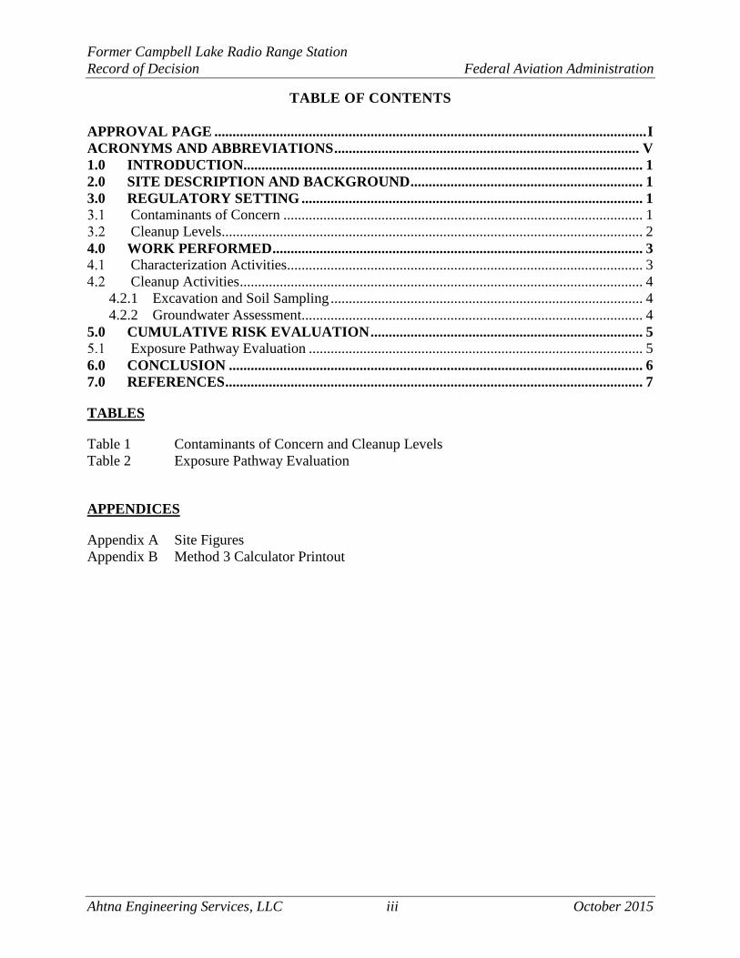
TABLE OF CONTENTS
APPROVAL PAGE ....................................................................................................................... I ACRONYMS AND ABBREVIATIONS .................................................................................... V 1.0 INTRODUCTION.............................................................................................................. 1 2.0 SITE DESCRIPTION AND BACKGROUND ................................................................ 1 3.0 REGULATORY SETTING .............................................................................................. 1
Contaminants of Concern ................................................................................................... 1 Cleanup Levels.................................................................................................................... 2
4.0 WORK PERFORMED ...................................................................................................... 3 Characterization Activities .................................................................................................. 3 Cleanup Activities ............................................................................................................... 4 4.2.1 Excavation and Soil Sampling ...................................................................................... 4 4.2.2 Groundwater Assessment.............................................................................................. 4
5.0 CUMULATIVE RISK EVALUATION ........................................................................... 5 Exposure Pathway Evaluation ............................................................................................ 5
6.0 CONCLUSION .................................................................................................................. 6 7.0 REFERENCES ................................................................................................................... 7
TABLES
Table 1 Contaminants of Concern and Cleanup Levels Table 2 Exposure Pathway Evaluation
APPENDICES
Appendix A Site Figures Appendix B Method 3 Calculator Printout

Former Campbell Lake Radio Range Station Record of Decision Federal Aviation Administration
Ahtna Engineering Services, LLC iv October 2015
(This Page Intentionally Left Blank)

Former Campbell Lake Radio Range Station Record of Decision Federal Aviation Administration
Ahtna Engineering Services, LLC v October 2015
ACRONYMS AND ABBREVIATIONS
AAC ...............Alaska Administrative Code ADEC .............Alaska Department of Environmental Conservation Ahtna ..............Ahtna Environmental Services, LLC AOC ...............Area of concern bgs ..................below ground surface BTEX .............benzene, toluene, ethylbenzene, and xylenes CY ..................cubic yard DRO ...............diesel range organics EPA ................Environmental Protection Agency FAA................Federal Aviation Administration GRO ...............gasoline range organics JBER ..............Joint Base Elmendorf Richardson MEI ................Mass Excavation, Inc. Montauk .........Montauk Environmental Engineering mg/kg .............Milligrams per kilogram mg/L ...............milligrams per liter PAH................polynuclear aromatic hydrocarbon PCB ................polychlorinated biphenyls PID .................photoionization detector RCRA .............Resource Conservation Recovery Act ROD ...............Record of Decision RRO ...............residual range organics SIM ................selective ion monitoring SPAR .............Spill Prevention and Response SW..................Solid Waste VOC ...............volatile organic compound

Former Campbell Lake Radio Range Station Record of Decision Federal Aviation Administration
Ahtna Engineering Services, LLC vi October 2015
(This Page Intentionally Left Blank)

Former Campbell Lake Radio Range Station Record of Decision Federal Aviation Administration
Ahtna Engineering Services, LLC 1 October 2015
ADEC Hazard ID: 26126
ADEC File Number: 2100.38.544
1.0 INTRODUCTION
This document presents a Record of Decision (ROD) and information necessary to support a decision regarding the cleanup status of one area of concern (AOC) located at the Federal Aviation Administration (FAA) Former Campbell Lake Radio Range Station, Anchorage, Alaska. The cleanup status for this AOC shall be Closed as Cleanup Complete with no institutional controls. This ROD was developed in accordance with the Alaska Department of Environmental Conservation (ADEC) Guidance on Decision Documentation under the Site Cleanup Rules (18 Alaska Administrative Code [AAC] 75.325 – 18 AAC 75.390), dated July 1999 and ADEC Site Closure Memorandum (2009). Most of the site specific information provided in this document can be found in the Draft Final Cleanup Report prepared by Ahtna Engineering Services (Ahtna), dated March 2014.
2.0 SITE DESCRIPTION AND BACKGROUND
The Former Campbell Lake Radio Range Station site is located at approximately 61°07’41.15” North latitude and -149°57’22.95” West longitude, within the Resolution Pointe subdivision, Anchorage, Alaska (Figures 1 and 2, Appendix A). This property is owned by the Hickel Investment Company of Anchorage, Alaska. The FAA occupied the project site (via a lease agreement with Hickel Investment Company) from approximately 1955 to 1976, during which time they constructed and operated a four-course radio range navigation facility (Montauk Environmental Engineering [Montauk], 2013).
The formerly leased land is currently undergoing development for residential housing. On August 10, 2013, Mass Excavation, Inc. (MEI), the housing development project’s general contractor, was attempting to install a water main within the housing development project area. During installation, stained subsurface soils with a petroleum hydrocarbon odor were observed by MEI personnel. The stained soils were encountered when a trench was excavated to a depth of approximately 12 feet below ground surface (bgs). Ponded water with a visible sheen was observed within the trench as noted by the environmental contractor first present at the site (Montauk, 2013). The spill was reported to the ADEC SPAR division on August 15, 2013, where it received the designation of Spill Report No. 13239922704. On September 17, 2013, this site was added to the ADEC Contaminated Sites Database and assigned File ID 2100.38.544 and Hazard ID 26126.
3.0 REGULATORY SETTING
Contaminants of Concern
Contaminants of concern in soil at this site were based on analytical results for samples collected during the characterization phase of this removal action. Contaminants of concern identified in soil included diesel-range organics (DRO), gasoline-range organics (GRO), 1- and 2-methylnaphthalene, and volatile organic compounds (VOCs).
Former Campbell Lake Radio Range Station Record of Decision Federal Aviation Administration
Ahtna Engineering Services, LLC 2 October 2015
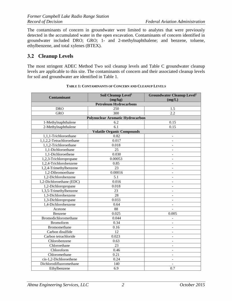
The contaminants of concern in groundwater were limited to analytes that were previously detected in the accumulated water in the open excavation. Contaminants of concern identified in groundwater included DRO; GRO; 1- and 2-methylnaphthalene; and benzene, toluene, ethylbenzene, and total xylenes (BTEX).
Cleanup Levels
The most stringent ADEC Method Two soil cleanup levels and Table C groundwater cleanup levels are applicable to this site. The contaminants of concern and their associated cleanup levels for soil and groundwater are identified in Table 1.
TABLE 1: CONTAMINANTS OF CONCERN AND CLEANUP LEVELS
Contaminant Soil Cleanup Level1 (mg/kg)
Groundwater Cleanup Level2 (mg/L)
Petroleum Hydrocarbons DRO 250 1.5 GRO 300 2.2
Polynuclear Aromatic Hydrocarbon 1-Methylnaphthalene 6.2 0.15 2-Methylnaphthalene 6.1 0.15
Volatile Organic Compounds 1,1,1-Trichloroethane 0.82 -
1,1,2,2-Tetrachloroethane 0.017 - 1,1,2-Trichloroethane 0.018 - 1,1-Dichloroethane 25 - 1,1-Dichloroethene 0.030 -
1,2,3-Trichloropropane 0.00053 - 1,2,4-Trichlorobenzene 0.85 - 1,2,4-Trimethylbenzene 23 -
1,2-Dibromoethane 0.00016 - 1,2-Dichlorobenzene 5.1 -
1,2-Dichloroethane (EDC) 0.016 - 1,2-Dichloropropane 0.018 -
1,3,5-Trimethylbenzene 23 - 1,3-Dichlorobenzene 28 - 1,3-Dichloropropane 0.033 - 1,4-Dichlorobenzene 0.64 -
Acetone 88 - Benzene 0.025 0.005
Bromodichloromethane 0.044 - Bromoform 0.34 -
Bromomethane 0.16 - Carbon disulfide 12 -
Carbon tetrachloride 0.023 - Chlorobenzene 0.63 - Chloroethane 23 - Chloroform 0.46 -
Chloromethane 0.21 - cis-1,2-Dichloroethene 0.24 -
Dichlorodifluoromethane 140 - Ethylbenzene 6.9 0.7

Former Campbell Lake Radio Range Station Record of Decision Federal Aviation Administration
Ahtna Engineering Services, LLC 3 October 2015
Contaminant Soil Cleanup Level1 (mg/kg)
Groundwater Cleanup Level2 (mg/L)
Hexachlorobutadiene 0.12 - Isopropylbenzene 51 -
Methyl tert-butyl ether 1.3 - Methylene chloride 0.016 -
Naphthalene 20 - n-Butylbenzene 15 - n-Propylbenzene 15 - sec-Butylbenzene 12 -
Styrene 0.96 - tert-Butylbenzene 12 - Tetrachloroethene 0.024 -
Toluene 6.5 1.0 trans-1,2-Dichloroethene 0.37 -
Trichloroethene 0.02 - Trichlorofluoromethane 86 -
Vinyl chloride 0.0085 - Xylenes (total) 63 10.0
Key: 1 Based on ADEC Method Two, Under 40-Inch Zone cleanup levels provided in 18 AAC 75, Tables B1 and B2 2 Based on ADEC cleanup levels provided in 18 AAC 75, Table C
4.0 WORK PERFORMED
Montauk personnel conducted emergency response removal action activities on August 15, 2013, and continued the soil excavation activities on September 12, 2013. Ahtna personnel conducted additional soil excavation activities at the site from September 18 to September 25, 2013; groundwater monitoring well installation and groundwater assessment activities from February 24 to February 26, 2014; and a second round of groundwater assessment activities on August 7, 2014.
Characterization Activities
A total of seven soil characterization samples were collected for offsite laboratory analysis. Samples were submitted to an ADEC-approved laboratory for the following analyses:
• Gasoline-range organics (GRO) by Alaska Method (AK) 101; • Diesel-range organics (DRO) by AK 102; • Residual-range organics (RRO) by AK 103; • Volatile organic compounds (VOCs) – full suite by United States Environmental Protection
Agency (EPA) Solid Waste (SW) Method 8260B; • Polynuclear aromatic hydrocarbons (PAHs) by EPA SW8270C selective ion monitoring
(SIM); • Pesticides by EPA SW8081A; • Polychlorinated biphenyls (PCBs) by EPA SW8082A; and • Resource Conservation Recovery Act (RCRA) metals (8) by EPA SW6020 (arsenic, barium,
cadmium, chromium, lead, mercury, nickel, and vanadium).
Former Campbell Lake Radio Range Station Record of Decision Federal Aviation Administration
Ahtna Engineering Services, LLC 4 October 2015
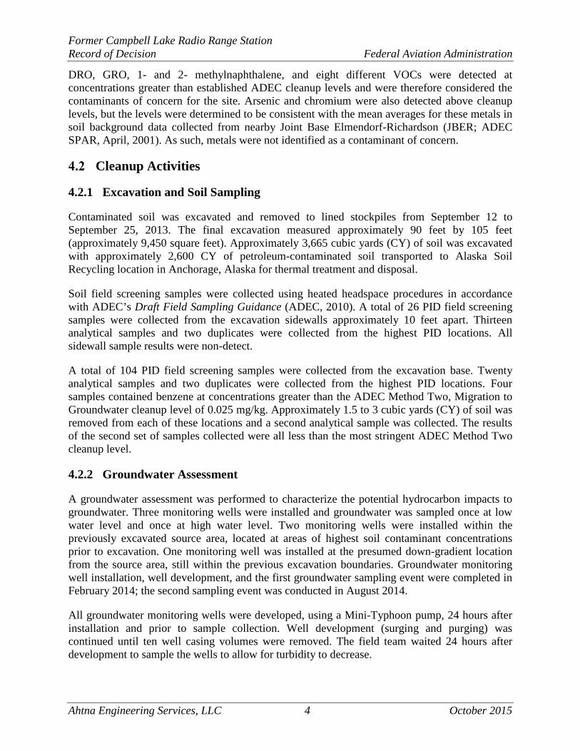
DRO, GRO, 1- and 2- methylnaphthalene, and eight different VOCs were detected at concentrations greater than established ADEC cleanup levels and were therefore considered the contaminants of concern for the site. Arsenic and chromium were also detected above cleanup levels, but the levels were determined to be consistent with the mean averages for these metals in soil background data collected from nearby Joint Base Elmendorf-Richardson (JBER; ADEC SPAR, April, 2001). As such, metals were not identified as a contaminant of concern.
Cleanup Activities
4.2.1 Excavation and Soil Sampling
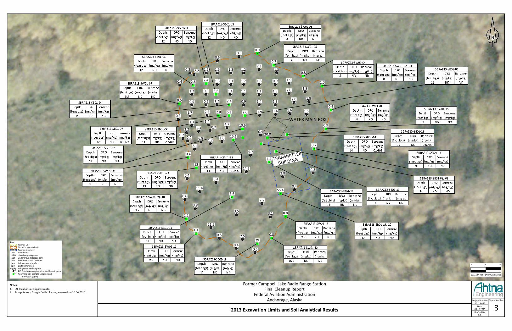
Contaminated soil was excavated and removed to lined stockpiles from September 12 to September 25, 2013. The final excavation measured approximately 90 feet by 105 feet (approximately 9,450 square feet). Approximately 3,665 cubic yards (CY) of soil was excavated with approximately 2,600 CY of petroleum-contaminated soil transported to Alaska Soil Recycling location in Anchorage, Alaska for thermal treatment and disposal.
Soil field screening samples were collected using heated headspace procedures in accordance with ADEC’s Draft Field Sampling Guidance (ADEC, 2010). A total of 26 PID field screening samples were collected from the excavation sidewalls approximately 10 feet apart. Thirteen analytical samples and two duplicates were collected from the highest PID locations. All sidewall sample results were non-detect.
A total of 104 PID field screening samples were collected from the excavation base. Twenty analytical samples and two duplicates were collected from the highest PID locations. Four samples contained benzene at concentrations greater than the ADEC Method Two, Migration to Groundwater cleanup level of 0.025 mg/kg. Approximately 1.5 to 3 cubic yards (CY) of soil was removed from each of these locations and a second analytical sample was collected. The results of the second set of samples collected were all less than the most stringent ADEC Method Two cleanup level.
4.2.2 Groundwater Assessment
A groundwater assessment was performed to characterize the potential hydrocarbon impacts to groundwater. Three monitoring wells were installed and groundwater was sampled once at low water level and once at high water level. Two monitoring wells were installed within the previously excavated source area, located at areas of highest soil contaminant concentrations prior to excavation. One monitoring well was installed at the presumed down-gradient location from the source area, still within the previous excavation boundaries. Groundwater monitoring well installation, well development, and the first groundwater sampling event were completed in February 2014; the second sampling event was conducted in August 2014.
All groundwater monitoring wells were developed, using a Mini-Typhoon pump, 24 hours after installation and prior to sample collection. Well development (surging and purging) was continued until ten well casing volumes were removed. The field team waited 24 hours after development to sample the wells to allow for turbidity to decrease.
Former Campbell Lake Radio Range Station Record of Decision Federal Aviation Administration
Ahtna Engineering Services, LLC 5 October 2015
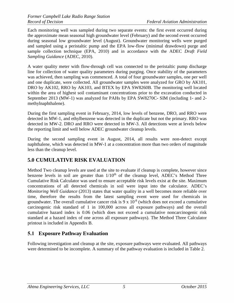
Each monitoring well was sampled during two separate events: the first event occurred during the approximate mean seasonal high groundwater level (February) and the second event occurred during seasonal low groundwater level (August). Groundwater monitoring wells were purged and sampled using a peristaltic pump and the EPA low-flow (minimal drawdown) purge and sample collection technique (EPA, 2010) and in accordance with the ADEC Draft Field Sampling Guidance (ADEC, 2010).
A water quality meter with flow-through cell was connected to the peristaltic pump discharge line for collection of water quality parameters during purging. Once stability of the parameters was achieved, then sampling was commenced. A total of four groundwater samples, one per well and one duplicate, were collected. All groundwater samples were analyzed for GRO by AK101, DRO by AK102, RRO by AK103, and BTEX by EPA SW8260B. The monitoring well located within the area of highest soil contaminant concentrations prior to the excavation conducted in September 2013 (MW-1) was analyzed for PAHs by EPA SW8270C- SIM (including 1- and 2-methylnaphthalene).
During the first sampling event in February, 2014, low levels of benzene, DRO, and RRO were detected in MW-1, and ethylbenzene was detected in the duplicate but not the primary. RRO was detected in MW-2. DRO and RRO were detected in MW-3. All detections were at levels below the reporting limit and well below ADEC groundwater cleanup levels.
During the second sampling event in August, 2014, all results were non-detect except naphthalene, which was detected in MW-1 at a concentration more than two orders of magnitude less than the cleanup level.
5.0 CUMULATIVE RISK EVALUATION
Method Two cleanup levels are used at the site to evaluate if cleanup is complete, however since benzene levels in soil are greater than 1/10th of the cleanup level, ADEC’s Method Three Cumulative Risk Calculator was used to ensure acceptable risk levels exist at the site. Maximum concentrations of all detected chemicals in soil were input into the calculator. ADEC’s Monitoring Well Guidance (2013) states that water quality in a well becomes more reliable over time, therefore the results from the latest sampling event were used for chemicals in groundwater. The overall cumulative cancer risk is 9 x 10⁻⁸ (which does not exceed a cumulative carcinogenic risk standard of 1 in 100,000 across all exposure pathways) and the overall cumulative hazard index is 0.06 (which does not exceed a cumulative noncarcinogenic risk standard at a hazard index of one across all exposure pathways). The Method Three Calculator printout is included in Appendix B.
Exposure Pathway Evaluation
Following investigation and cleanup at the site, exposure pathways were evaluated. All pathways were determined to be incomplete. A summary of the pathway evaluation is included in Table 2.

Former Campbell Lake Radio Range Station Record of Decision Federal Aviation Administration
Ahtna Engineering Services, LLC 6 October 2015
TABLE 2: EXPOSURE PATHWAY EVALUATION
Pathway Result Explanation Surface Soil Contact Pathway
Incomplete No contamination is present in surface soil (0 to 2 feet below
ground surface). Sub-Surface Soil Contact Pathway
Incomplete Contamination is below ingestion cleanup levels.
Inhalation – Outdoor Air Pathway Incomplete
Contamination is below inhalation cleanup levels.
Inhalation – Indoor Air (vapor intrusion)
Pathway Incomplete
No buildings are present or plan to be built within 30 feet of the contamination.
Groundwater Ingestion Pathway Incomplete
Groundwater contamination is not present.
Surface Water Ingestion Pathway Incomplete
No surface water exists near the site.
Wild and Farmed Foods Ingestion
Pathway Incomplete
Contaminants of concern do not have the potential to bioaccumulate in plants or animals.
Exposure to Ecological Receptors Pathway Incomplete
Contamination is below cleanup levels and limited to the sub-surface.
6.0 CONCLUSION
Analytical results for soil and groundwater samples collected at the Former Campbell Lake Radio Range Station AOC indicate that contaminant concentrations are less than the ADEC Method Two, Under 40 Inch Zone, Migration to Groundwater cleanup levels and are determined to be within acceptable cumulative risk using the ADEC Method Three Calculator.
Therefore, this AOC is requested to be granted a Cleanup Complete determination with no institutional controls, in accordance with 18 AAC 75.380(d)(1).
In addition, this AOC is subject to the following conditions:
• Under 18 AAC 75.380(d)(1), ADEC may require additional site characterization or cleanup action if new information is discovered which leads ADEC to make a determination that the cleanup described in this ROD is not protective of human health, safety, and welfare or the environment.
• Any proposal to transport soil or groundwater off-site requires ADEC approval in accordance with 18 AAC 75.325. A “site” [as defined by 18 AAC 75.990 (115)] means an area that is contaminated, including areas contaminated by the migration of hazardous substance from a source area, regardless of property ownership.
• Movement or use of contaminated material in a manner that results in a violation of 18 AAC 70 water quality standards is prohibited.
Following the finalization of this document, a work plan will be developed to decommission the three monitoring wells at the site. After the completion of the proposed work, a well decommissioning report will be submitted to ADEC.

Former Campbell Lake Radio Range Station Record of Decision Federal Aviation Administration
Ahtna Engineering Services, LLC 7 October 2015
7.0 REFERENCES
Alaska Department of Environmental Conservation (ADEC), 2013. Monitoring Well Guidance, September 2013.
ADEC, 2012. Title 18 Alaska Administrative Code 75 Oil and Other Hazardous Substances Pollution Control, April 8.
ADEC, 2010. Draft Field Sampling Guidance, May 2010.
ADEC, 2009. Site Closure Memorandum, July 24.
ADEC, 2001. Record of Decision Regarding Cleanup Levels USGS Government Hill Site. April.
ADEC, 1999. Guidance on Decision Documentation under the Site Cleanup Rules (18 Alaska Administrative Code [AAC] 75.325 – 18 AAC 75.390), July.
Ahtna Environmental Services, 2015. Draft Final Cleanup Report, Federal Aviation Administration, Former Campbell Lake Radio Range Station, Resolution Pointe, Anchorage, Alaska, March.
Environmental Protection Agency (EPA), 2010. Low Stress (low flow) Purging and Sampling Procedure for the Collection of Groundwater Samples from Monitoring Wells, January 2010.
Montauk Environmental Engineering (Montauk), 2013. Resolution Pointe Housing Development Spill Cleanup Plan. September 10.

(This Page Intentionally Left Blank)

Former Campbell Lake Radio Range Station Record of Decision Federal Aviation Administration
Ahtna Engineering Services, LLC October 2015
APPENDIX A
SITE FIGURES

Former Campbell Lake Radio Range Station Record of Decision Federal Aviation Administration
Ahtna Engineering Services, LLC October 2015
(This Page Intentionally Left Blank)

Project Number:20125.066
Date:03.19.2015Drafted By:
G.R.
Engineering
Figure Number:
1
Notes:1. All locations are approximate.2. Image is from Google Earth accessed on 01.22.2014.
0 900 1800
SCALE IN FEET (APPROXIMATE)
N
Pacific Ocean
Bering Sea
Chukchi Sea
Arctic Ocean
Anchorage
Fairbanks
W DIMOND BLVD
MIN
NES
OTA
DR
O'Malley Rd
W KLATT RD
SOUTHPORT DR
C ST
ARCT
IC B
LVD
W 100TH AVE
State and Site Vicinity Maps
Z:\C
ampb
ell L
ake\
2012
5.06
6\CA
D\Cl
eanu
p Re
port
\Cam
pbel
l Lak
e Pr
ojec
t_CF
1F2F
4.dw
g
PROJECTLOCATION
Former Campbell Lake Radio Range StationFinal Cleanup Report
Federal Aviation AdministrationAnchorage, Alaska

(This Page Intentionally Left Blank)

Endeavor Circle
Point Resolution Dr.
Engineering
Figure Number:
2
Key: Project Site
Former Structure Former AST
Notes:1. All locations are approximate.2. Image is from ArcMap accessed on 10.02.2013.
0 50 100
SCALE IN FEET (APPROXIMATE)
N
Project Number:20125.066
Date:12.09.2014Drafted By:
G.R.Z:\C
ampb
ell L
ake\
2012
5.06
6\CA
D\Cl
eanu
p Re
port
\Cam
pbel
l Lak
e Pr
ojec
t_CF
1F2F
4.dw
g
Site Plan
Former Campbell Lake Radio Range StationFinal Cleanup Report
Federal Aviation AdministrationAnchorage, Alaska

(This Page Intentionally Left Blank)
M:\AES\Project Files - Reorganized\FAA\20125_FAA IDIQ WSA DTFAAL-10-D-00002\20125.066_TO 66 Campbell Lake\08_Drawings or Figures\References\anc1964.tif
2.11.3
0.50.5
1.6 1.3 1.2
1.72.11.3
1.5
1.8 0.92.6
0.5 2.4
20.8
0.4
12
3.6
2.2
1.10.8
29
0.8
55.4
4.4
0.7
0.6
0.8
1.01.9
2.0 1.5
0.4
3.1
7.50.5
21.5
0.50.4
0.9
1.2
0.3 2.2
5.7
0.4
2.2
3.5
2.80.314.2
5.4
11.4
0.6
3.8
0.4
0.3
0.9 1.2
0.9 1.4 1.1 1.1 1.3
0.4 2.4
0.9
0.7
3.6
TRANSMITTER
BUILDING
10.6
2.1
6.8 1.2 1.02.20.2 15.1
1.7 2.3 5.12.8
4.71.4
0.71.31.1
3.20.9
2.0 1.8
1.5
0.9 1.4
1.9 1.6
1.8
1.62.6
0 10 20
SCALE IN FEET (APPROXIMATE)
Engineering
Figure Number:
3
Key: Former UST 2013 Excavation limits Former Structure
ND non-detect DRO diesel range organics UST underground storage tank PID Photoionization Detector bgs below ground surface ppm parts per millionmg/kg milligrams per kilogram
PID Fieldscreening Location and Result (ppm) Analytical Soil Sample Location and
PID result (ppm)
Notes:1. All locations are approximate.2. Image is from Google Earth : Alaska, accessed on 10.04.2013.
N
Project Number:20125.066
Date:03.19.2015Drafted By:
G.R.
2013 Excavation Limits and Soil Analytical Results
0.4
0.4
Former Campbell Lake Radio Range StationFinal Cleanup Report
Federal Aviation AdministrationAnchorage, Alaska

(This Page Intentionally Left Blank)

Z:\Data_library\Aerials\Anchorage\anc1964.tifTRANSMITTER
BUILDING
Engineering
Figure Number:
4
N
0 10 20
SCALE IN FEET (APPROXIMATE)
Notes:1. All locations are approximate.2. Image is from ArcMap accessed on 10.02.2013.
Key: amsl above mean sea level mg/L milligrams per liter ug/L micrograms per liter
Former Structure Excavation Limits
Monitoring Wells Groundwater Flow Direction
L:\C
ampb
ell L
ake\
2012
5.06
6\CA
D\Cl
eanu
p Re
port
\Cam
pbel
l Lak
e Pr
ojec
t_CF
1F2F
4.dw
g
Groundwater Analytical Results and Elevations
Project Number:20125.066
Date:06.16.2015Drafted By:
G.R.
Former Campbell Lake Radio Range StationFinal Cleanup Report
Federal Aviation AdministrationAnchorage, Alaska

(This Page Intentionally Left Blank)

Former Campbell Lake Radio Range Station Record of Decision Federal Aviation Administration
Ahtna Engineering Services, LLC October 2015
APPENDIX B
METHOD 3 CALCULATOR PRINTOUT
Former Campbell Lake Radio Range Station Record of Decision Federal Aviation Administration
Ahtna Engineering Services, LLC October 2015
(This Page Intentionally Left Blank)

10/20/2014 DEC - Contaminated Sites Program - Method 3 Calculator STEP 5: Review Cumulative Risks
http://dec.alaska.gov/applications/spar/webcalc/dsp_cumRisks.asp?hdn_scenCode=ResU40 1/2
Method Three & Cumulative Risk Calculator
Former Campbell Lake Radio Relay StationThe following are cumulative cancer risks and hazard quotients by chemical.
Note that petroleum ranges (GRO, DRO, and RRO) are not included in cumulative risks. Also, if PCBs or dioxins are present at the site, thecumulative risks associated with these chemicals may also need to be considered; please contact the ADEC project manager for your site forinformation on how to address these chemicals.
Chemicals in red are carcinogenic.
Direct Contact RisksChemical Soil Concentration
(mg/kg) Cancer Risk Hazard Quotient
Acenaphthene 0.0404 0 0.000014
Benzene 0.0206 0.0000000014 0.00005
Benzo(k)fluoranthene 0 0 0
Benzo(g,h,i)perylene 0 0 0
Benzo(a)pyrene 0 0 0
Dibenzo(a,h)anthracene 0 0 0
Ethylbenzene 0.248 0 0.000025
Indeno(1,2,3-c,d)pyrene 0 0 0
1-Methylnaphthalene 0.246 0 0.00088
2-Methylnaphthalene 0.333 0 0.0012
Naphthalene 0.127 0 0.000091
Phenanthrene 0.116 0 0.0000056
Xylenes (total) 0.246 0 0.000012
Inhalation RisksChemical Soil Concentration
(mg/kg) Cancer Risk Hazard Quotient
Acenaphthene 0.0404 0 0
Benzene 0.0206 0.000000019 0.00019
Benzo(k)fluoranthene 0 0 0
Benzo(g,h,i)perylene 0 0 0
Benzo(a)pyrene 0 0 0
Dibenzo(a,h)anthracene 0 0 0
Ethylbenzene 0.248 0.000000023 0.000049
Indeno(1,2,3-c,d)pyrene 0 0 0
1-Methylnaphthalene 0.246 0 0.00032
2-Methylnaphthalene 0.333 0 0.00044
Naphthalene 0.127 0.000000045 0.0011
Phenanthrene 0.116 0 0

10/20/2014 DEC - Contaminated Sites Program - Method 3 Calculator STEP 5: Review Cumulative Risks
http://dec.alaska.gov/applications/spar/webcalc/dsp_cumRisks.asp?hdn_scenCode=ResU40 2/2
Xylenes (total) 0.246 0 0.00046
Groundwater RisksChemical Groundwater
Concentration (mg/L) Cancer Risk Hazard Quotient
Acenaphthene 0 0 0
Benzene 0 0 0
Benzo(k)fluoranthene 0 0 0
Benzo(g,h,i)perylene 0 0 0
Benzo(a)pyrene 0 0 0
Dibenzo(a,h)anthracene 0 0 0
Ethylbenzene 0 0 0
Indeno(1,2,3-c,d)pyrene 0 0 0
1-Methylnaphthalene 0 0 0
2-Methylnaphthalene 0 0 0
Naphthalene 0.044 0 0.06
Phenanthrene 0 0 0
Xylenes (total) 0 0 0
Cumulative RiskCumulative Cancer Risk 0.00000009
Cumulative Hazard Index 0.06

Former Campbell Lake Radio Range Station Final Cleanup Report Federal Aviation Administration
Ahtna Engineering Services, LLC October 2015
APPENDIX H
ADEC RESPONSE TO COMMENTS AND FINAL APPROVAL LETTER

Former Campbell Lake Radio Range Station Final Cleanup Report Federal Aviation Administration
Ahtna Engineering Services, LLC October 2015
(This Page Intentionally Left Blank)
