final environmental impact report geology and soils · final environmental impact report geology...
TRANSCRIPT
Valiano Project Subchapter 2.10
Final Environmental Impact Report Geology and Soils
2.10-1
2.10 Geology and Soils
This section describes the existing geologic and soils conditions within the Project site and vicinity, identifies regulatory requirements and industry standards associated with geologic and
soils issues, and evaluates potential impacts and mitigation measures related to implementation
of the Proposed Project.
Two Geotechnical Investigations and two related Addenda to address technical comments by the County have been prepared for the proposed Project by Geocon. Specifically, these include an
analysis and related Addendum of the main (northern) portion of the Project site encompassing
approximately 191 acres (Neighborhoods 1 through 4 and associated open space areas) (Geocon 2013a, 2012a), a separate analysis of the 48-acre southeastern site area (Neighborhood 5)
(Geocon 2012b), and the noted Addenda (Geocon 2014a, 2013a). These investigations are summarized below along with other applicable information, with the complete reports included
in Appendix K of this EIR.
2.10.1 Existing Conditions
2.10.1.1 Geologic Setting
Regional Geology/Topography
The Project site is located within the Peninsular Ranges Geomorphic Province, a region characterized by northwest-trending structural blocks and intervening fault zones. Typical
lithologies in the Peninsular Ranges include a variety of igneous intrusive (i.e., formed below the
surface) rocks associated with the Cretaceous (between approximately 65 and 135 million years old) Southern California Batholith (a large igneous intrusive body), with such igneous bodies
typically intruded into older metavolcanic and/or metasedimentary units in western San Diego County. Basement rocks in the coastal portion of San Diego County are locally overlain by a
sequence of primarily Tertiary (between approximately 2 and 65 million years old) marine and
non-marine sedimentary strata, with most of these deposits associated with several sea level advance/retreat cycles over approximately the last 55 million years. The described geologic
sequence is locally overlain with Quaternary (less than approximately 2 million years old) materials such as alluvium, terrace deposits, and topsoil.
Topographically, the Peninsular Ranges Province is composed of generally parallel ranges of steep hills and mountains separated by alluvial valleys. More recent uplift and erosion has
produced the characteristic canyon and mesa topography present today in western San Diego County, as well as the deposition of Quaternary deposits as noted above.
Site Geology/Topography
Geologic and surficial units present within the Project site and adjacent areas (including proposed off-site road improvements) include Cretaceous/Jurassic-age (between approximately
65 and 200 million years old) metamorphic rocks; Cretaceous-age igneous intrusive (granitic) rocks; the Tertiary-age Santiago Formation; Quaternary-age terrace deposits, alluvium,
Valiano Project Subchapter 2.10
Final Environmental Impact Report Geology and Soils
2.10-2
colluvium and topsoil; and recent undocumented fill materials (i.e., fill not known to conform to current engineering standards for criteria such as composition and placement methodology).
Metamorphic rocks occur in the southeastern-most portion of the Project site, while granitic rocks are exposed along a number of steeper slopes and underlie much of the site and
surrounding areas. Terrace deposits occur beneath colluvium in the east-central portion of the
site, while alluvium is present within the larger on-site (and off-site) drainage courses. Colluvial deposits are present along the flanks and toes (bottoms) of most slopes in the central and
southern portions of the site, while much of the property and adjacent areas encompass an irregular and thin layer of Holocene-age (less than approximately 11,000 years old) native
topsoil. Additional descriptions of on-site and adjacent surficial and formational deposits are
provided below under the discussion of Stratigraphy.
On-site topography is generally characterized by a north-south trending ridge in the main portion of the property and a large knoll in the southeastern-most area, with several larger drainages
flanking these upland features. On-site elevations range from approximately 1,013 feet amsl
along the ridge top near the northwestern site boundary, to 614 feet amsl along the southeastern property boundary. Surface drainage from most of the Project site and adjacent areas flows
primarily to the east and south, with some variability due to local topography. Associated off-site flows continue generally south before ultimately entering Escondido Creek. The northern-most
portion of the site drains to the north and ultimately flows to San Marcos Creek.
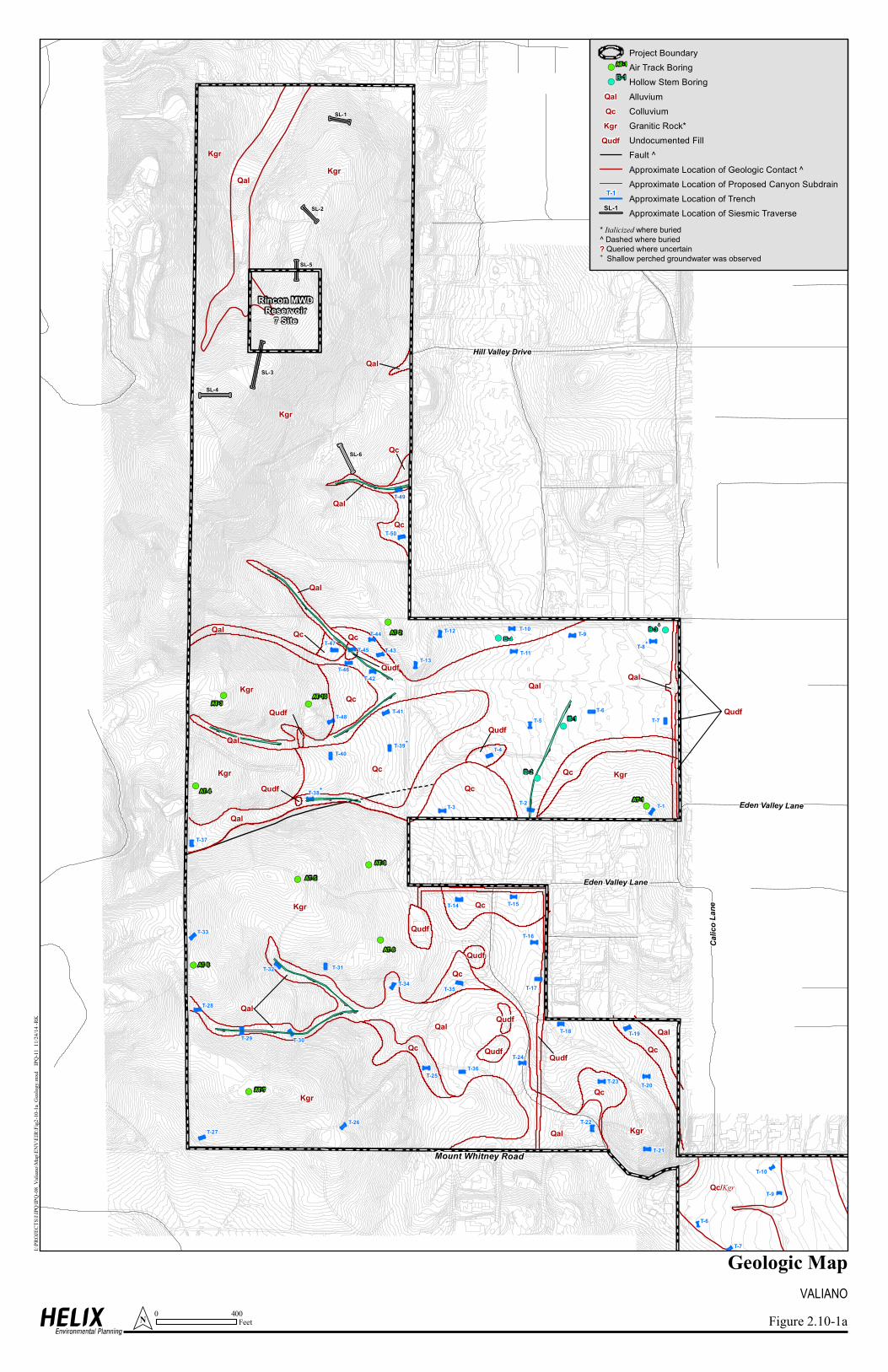
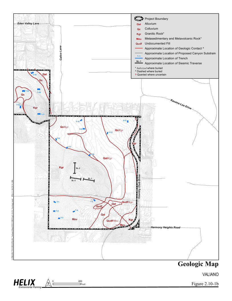
Stratigraphy
Surficial and geologic exposures within or underlying the Project site and vicinity are described
below in order of increasing age, with the principal units shown on Figure 2.10-1, Geologic Map.
Historic Undocumented Fill (Map Symbol Qudf)
Undocumented fill is present at numerous locations within the site and adjacent areas in
association with previous or current uses such as agriculture, equestrian facilities, and roads.
These materials typically consist of sandy deposits with variable amounts of gravel and cobble-size sediments, and as previously noted are assumed not to be in conformance with
applicable engineering standards.
Holocene Native Topsoils (Not Mapped)
Topsoil mapping within the Project site and vicinity has been conducted by the U.S. Natural
Resources Conservation Service (NRCS, formerly the U.S. Soil Conservation Service [SCS], 1973). Mapped soils within and adjacent to the Project impact footprint and adjacent areas
include 9 soil series encompassing 14 individual soil types. These soils are generally
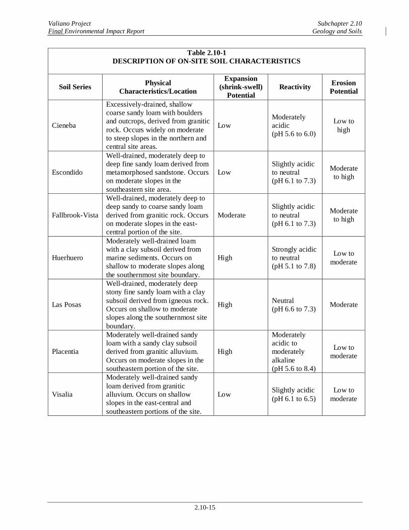
characterized by loams and sandy loams, with a summary of on-site soil series locations and features provided in Table 2.10-1, Description of On-site Soil Characteristics.
Valiano Project Subchapter 2.10
Final Environmental Impact Report Geology and Soils
2.10-3
Quaternary Colluvium (Map Symbol Qc)
Colluvial deposits consist generally of loose (unconsolidated) sandy clays and clayey sands with cobbles and occasional boulders. These materials are transported by gravity and occur primarily
along the flanks and toes of most on-site and adjacent slopes. Observed depths within the Project
site range up to approximately eight feet, with the thicker deposits generally occurring in the southeastern areas.
Quaternary Alluvium (Map Symbol Qal)
Alluvium was observed in a number of on-site drainages during geotechnical investigation, and is generally expected to occur in all such locations within and adjacent to the site (although the
large, central drainage in the southeastern site area was unavailable for field access due to environmental restrictions). Alluvial deposits typically consist of unconsolidated sandy materials
with variable amounts of gravel, cobbles, and occasional boulders. Estimated thicknesses range
from a few feet or less in small washes to over 20 feet in the larger drainages.
Quaternary Terrace Deposits (Not Mapped)
A relatively thin layer of terrace deposits was observed underlying colluvial materials in the
east-central portion of the site during subsurface explorations conducted as part of the Project geotechnical investigation. These deposits consist of mostly unconsolidated, medium dense to
dense silty sands that are occasionally slightly cemented. Due to their limited occurrence and the fact that they are not exposed at the surface, these materials are not shown on Figure 2.10-1.
Tertiary Santiago Formation (Not Mapped)
The Santiago Formation was encountered beneath undocumented fill deposits north of the site during off-site subsurface boring and trenching conducted as part of the Project geotechnical
investigation. This formation generally consists of dense to very dense, massive (i.e., lacking
defined structure, such as bedding) sandstone and claystone. While these materials were not encountered on-site and are thus not specifically mapped, the Santiago Formation could
potentially occur beneath surficial deposits as well in the northern portion of the site.
Cretaceous Granitic Rocks (Map Symbol Kgr)
Cretaceous-age granitic rocks are present within or beneath much of the site and adjacent areas,
and consist primarily of massive, coarse-grained tonalite that is hard to very hard and exhibits variable amounts of fracturing and weathering. The near-surface weathered zones are generally
subject to excavation with standard heavy ripping techniques, and locally include coarse-grained
sandy “soil” deposits derived from the weathered granitic rocks. The deeper unweathered granitic zones are very hard and would likely require blasting to accommodate Project
excavation.
Valiano Project Subchapter 2.10
Final Environmental Impact Report Geology and Soils
2.10-4
Jurassic/Cretaceous Metamorphic Rocks (Map Symbol Mzu)
Metasedimentary and/or metavolcanic units are present in the southeastern portion of the site and adjacent off-site areas, and are characterized by generally massive, fine- to coarse-grained dark
colored rocks with variable degrees of weathering by depth. Similar to the granitic rocks
described above, the near-surface metamorphic rocks are highly to moderately weathered and generally subject to excavation with standard heavy ripping techniques, while deeper less
weathered units would likely require blasting.
Groundwater
Shallow groundwater was encountered in alluvial deposits during subsurface geotechnical
explorations in the central and east-central portions of the site, at depths ranging from 6 to 11 feet below the surface. Specifically, groundwater was encountered in subsurface excavation
sites including B-3, T-8, T-38 and T-39, as shown on Figure 2.10-1a. These occurrences were
interpreted as perched aquifers, which consist generally of unconfined (i.e., not under pressure) groundwater contained by impermeable or semi-permeable strata, in this case the underlying
granitic rock. The presence and/or extent of perched groundwater bodies are typically associated with and influenced by seasonal precipitation, as well as local landscape and/or agricultural
irrigation. Shallow groundwater was not observed during geotechnical investigation in other
portions of the site.
Structure/Seismicity
The Project site is located within a broad, seismically active region characterized by a series of
northwest-trending faults associated with the San Andreas Fault System. No active or potentially active faults, County-designated Near-Source Shaking Zones, California Geological Survey
(CGS) Alquist-Priolo Earthquake Fault Zones, or County Special Study Fault Zones are mapped or known to occur within the Project site and vicinity (CGS 2010, 2007; County 2007a). The
closest active fault structures are located within the Newport-Inglewood (offshore)/Rose Canyon
Fault Zone, approximately 13 miles to the west (Table 2.10-2, Summary of Regional Fault Locations and Seismicity Data). Active faults are defined as those exhibiting historic seismicity
or displacement of Holocene materials, while potentially active faults have no historic seismicity and displace Pleistocene (between approximately 11,000 and 2 million years old) but not
Holocene strata. The described CGS and County fault zone designations are generally intended
to “[r]egulate development near active faults so as to mitigate the hazard of surface fault rupture” (CGS 2007a). The closest seismic hazard designations to the Project impact footprint are CGS
Earthquake Fault Zones located along onshore sections of the Rose Canyon Fault Zone approximately 20 miles to the southwest. An unnamed fault trace extends into the west-central
portion of the site (Figure 2.10-1), although this fault is mapped as pre-Quaternary in age by the
CGS (2010) and is identified as “inactive” in the Project Geotechnical Investigation (Geocon 2013a, 2012a).
Several additional major active faults are located within approximately 50 miles of the site, as
shown in Table 2.10-2. Estimated peak horizontal ground acceleration (or ground shaking) values associated with proximal active faults are also shown, with an estimated maximum peak
Valiano Project Subchapter 2.10
Final Environmental Impact Report Geology and Soils
2.10-5
acceleration value of 0.24g (where g equals the acceleration due to gravity) identified for the Project site in association with a magnitude 7.5 event along the Newport-Inglewood Fault Zone.
A site-specific analysis of peak ground acceleration was conducted for the Project site, based on a CGS computer modeling program. From this model, the peak ground acceleration values with a
10 percent chance of being exceeded in a 50-year period are 0.25g (firm rock), 0.27g (soft rock),
and 0.31g (alluvium). These estimated acceleration values, along with other applicable seismic considerations such as motion frequency/duration and CBC design criteria, are used to evaluate
related site-specific hazards such as liquefaction. Additional information on CBC criteria and associated Project seismic considerations is provided below under the discussion of Regulatory
Framework, as well as in Section 2.10.2, Analysis of Project Effects and Determination as to
Significance, and Appendix K.
2.10.1.2 Regulatory Setting
Development of the Proposed Project is subject to a number of regulatory requirements and
industry standards related to potential geologic hazards. These requirements and standards typically involve measures to evaluate risk and mitigate potential hazards through design and
construction techniques. Specific guidelines encompassing geologic criteria that may be applicable to the design and construction of the Proposed Project include: (1) the San Diego
County General Plan Safety Element (2011); (2) the County Guidelines for Determining
Significance – Geologic Hazards (2007a); (3) Title 8, Division 4 (Design Standards and Performance Requirements) and Division 7 (Excavation and Grading), and Title 5, Division 1
(Amendments to the State Building Standards Code) of the County Code of Regulatory Ordinances; (4) the International Code Council, Inc. (ICC) IBC (most recent update), and the
related CBC (CCR, Title 24, Part 2, 2010 edition); and (5) the Greenbook Committee of
Standard Specifications for Public Works Projects (most recent update). Regulatory requirements related to potential erosion and sedimentation effects (i.e., under the NPDES Construction
General Permit) are discussed in Section 3.1.3 of this EIR, Hydrology/Water Quality, due to their relationship to water quality issues. Summary descriptions of the listed geologic standards are
provided below, with specific elements applicable to the Proposed Project discussed in
Section 2.10.2.
County Standards
The San Diego County General Plan Safety Element is intended to identify and evaluate seismic
hazards in the County, and to provide policies to reduce the loss of life and property damage related to seismic hazards. Associated policies in the Safety Element applicable to the Proposed
Project include requirements to minimize risk resulting from seismic hazards and minimized personal injury and property damage by mudslides, landslides, or rockfalls. The Safety Element
requires conformance with applicable laws and standards such as the referenced County
Geologic Hazard Guidelines, the Alquist-Priolo Act (for Fault-Rupture Hazard Zones), the CBC/IBC, and the Greenbook.
The County Geologic Hazard Guidelines provide direction for evaluating environmental effects
related to geologic hazards. Specifically, these guidelines address potential adverse effects to life and property (pursuant to applicable CEQA standards) from hazards including fault rupture,
Valiano Project Subchapter 2.10
Final Environmental Impact Report Geology and Soils
2.10-6
ground shaking, liquefaction, landslides, rockfalls, and expansive soils. Significance guidelines are identified for the noted issues, as well as related regulatory standards, impact analysis
methodologies, potential mitigation/design strategies, and reporting requirements.
The County Excavation and Grading requirements are implemented through issuance of grading
permits, which apply to most projects involving more than 200 cy of material movement (e.g., grading and excavation). Specific requirements for such “Major Grading” efforts include,
among other criteria, use of qualified engineering and geotechnical consultants to design and implement grading plans, implementation of appropriate measures related to issues such as
manufactured slope design and construction, and conformance with requirements related to
issues including erosion and storm water controls.
County Building Code standards related to geotechnical concerns include applicable portions of the CBC and IBC, along with specific County amendments. The County Building Code is
implemented through the issuance of building permits, which may encompass requirements
related to preparation of soils reports and implementation of structural loading and drainage criteria.
International Building Code and Greenbook Standards
The IBC (which encompasses the former Uniform Building Code [UBC]) is produced by the ICC (formerly the International Conference of Building Officials) to provide standard
specifications for engineering and construction activities. Publication of the Greenbook, the Standard Plans for Public Works Construction, is under the oversight of Public Works
Standards, Inc. (PWSI), a nonprofit mutual benefit corporation whose members include the
American Public Works Association, Associated General Contractors of California, and Engineering Contractors Association. The IBC and Greenbook provide standard specifications
for engineering and construction activities, including measures to address geologic and soil concerns. Specifically, these measures encompass issues such as seismic loading
(e.g., classifying seismic zones and faults), ground motion, engineered fill specifications
(e.g., compaction and moisture content), expansive soil characteristics, and pavement design. The referenced guidelines, while not comprising formal regulatory requirements per se, are
widely accepted by regulatory authorities and are routinely included in related standards such as municipal grading codes. The IBC and Greenbook guidelines are regularly updated to reflect
current industry standards and practices, including criteria such as The American Society of Civil
Engineers (ASCE) and ASTM International (ASTM, formerly known as the American Society for Testing and Materials).
California Building Code Standards
The CBC encompasses a number of requirements related to geologic issues. Specifically, these include general provisions (Chapter 1); structural design, including soil and seismic loading
(Chapters 16/16A); structural tests and special inspections, including seismic resistance (Chapters 17/17A); soils and foundations (Chapters 18/18A); concrete (Chapters 19/19);
masonry (Chapters 21/21A); wood, including consideration of seismic design categories (Chapter 23); construction safeguards (Chapter 33); and grading, including excavation, fill,
Valiano Project Subchapter 2.10
Final Environmental Impact Report Geology and Soils
2.10-7
drainage, and erosion control criteria (Appendix J). The CBC encompasses standards from other applicable sources, including the IBC and ASTM International, with appropriate amendments
and modifications to reflect site-specific conditions and requirements in California.
2.10.2 Analysis of Project Effects and Determination as to Significance
2.10.2.1 Fault Rupture
Guideline for the Determination of Significance
A significant geologic impact would occur if:
1. The Project proposes any building or structure to be used for human occupancy over or within 50 feet of the trace of an Alquist-Priolo fault or County Special Study Zone fault.
2. The Project proposes the following uses within an Alquist-Priolo Zone which are prohibited by the County:
a. Uses containing structures with a capacity of 300 people or more. Any use having the
capacity to serve, house, entertain, or otherwise accommodate 300 or more persons at
any one time.
b. Uses with the potential to severely damage the environment or cause major loss of life. Any use having the potential to severely damage the environment or cause major
loss of life if destroyed, such as dams, reservoirs, petroleum storage facilities, and
electrical power plants powered by nuclear reactors.
c. Specific civic uses. Police and fire stations, schools, hospitals, rest homes, nursing homes, and emergency communication facilities.
Guideline Source
These guidelines are based on the County Guidelines for Determining the Significance – Geologic Hazards (2007h).
Analysis
Seismic fault (or ground) rupture is the physical surface (or near surface) displacement (typically along a fault structure) resulting from earthquake-induced movement. No known active or
potentially active faults, or associated Alquist-Priolo/County Fault Zones, are mapped or known
to occur within the Project site and vicinity. The closest such designation consists of an Alquist-Priolo Earthquake Fault Zone located along onshore sections of the Rose Canyon Fault
Zone approximately 20 miles southwest of the Project site (CGS 2010, 2007; County 2007a; Appendix K). Accordingly, the potential for associated seismic ground rupture is considered low.
As previously noted, an unnamed fault trace extends into the west-central portion of the site (Figure 2.10-1), although this fault is mapped as pre-Quaternary in age by the CGS (2010), is

Valiano Project Subchapter 2.10
Final Environmental Impact Report Geology and Soils
2.10-8
identified as “inactive” in the Project Geotechnical Investigation (Geocon 2013a, 2012a), and is not associated with any Alquist-Priolo or County Fault Zone designations. Based on the
described conditions, potential Project-related impacts associated with seismic ground
rupture or the placement of prohibited uses within an Alquist-Priolo Earthquake Fault
Zone would be less than significant.
2.10.2.2 Seismic Ground Acceleration (Ground Shaking)
Guideline for the Determination of Significance
A significant geologic impact would occur if:
3. The Project is located within a County Near-Source Shaking Zone or within Seismic Zone 4 and the Project does not conform with the International Building Code (IBC,
which encompasses the former Uniform Building Code [UBC]).
Guideline Source
This guideline is based on the County Guidelines for Determining the Significance – Geologic
Hazards (2007h).
Analysis
Seismically generated ground shaking typically represents the most substantial hazard associated
with earthquakes, and can affect the integrity of surface and subsurface facilities such as
structures, foundations, and utilities. Specifically, associated potential effects can occur directly from vibration-related damage to rigid structures, or indirectly through associated hazards
including liquefaction (as described below). While the Project site is not located within or adjacent to a County Near-Source Shaking Zone (County 2007a), like all of San Diego County it
is within a Seismic Zone 4 designation. Seismic Zone 4 is the highest risk category of the four
nationwide seismic zones, and generally exhibits a 10 percent chance of experiencing an earthquake-generated peak ground acceleration of 0.4g within the next 50 years. For comparison
purposes, Seismic Zone 1 (the lowest risk category) exhibits a 10 percent chance of experiencing an earthquake-generated peak ground acceleration of 0.1g within the next 50 years.
Based on technical analysis conducted as part of the Project Geotechnical Investigation (and as previously described), the peak ground acceleration values with a 10 percent chance of being
exceeded in a 50-year period at the Project site are given as 0.25g for firm rock, 0.27g for soft rock, and 0.31g for alluvium (all of which are somewhat lower than the general 10 percent
recurrence ground acceleration level noted above for Seismic Zone 4). While the described levels
of ground shaking could potentially result in damage to Proposed Project facilities such as structures and utilities, the Project Geotechnical Investigation notes that:
While listing peak ground accelerations is useful for comparison of potential effects of fault
activity in a region, other considerations are important in seismic design, including the frequency
Valiano Project Subchapter 2.10
Final Environmental Impact Report Geology and Soils
2.10-9
and duration of motion and the soil conditions underlying the site. Seismic design should be evaluated in accordance with the CBC guidelines currently adopted by the County of San Diego.
Accordingly, the Geotechnical Investigation identifies a number of specific seismic design criteria to address the noted potential on-site ground shaking hazards, pursuant to applicable
criteria in the IBC/CBC and County Building Code (refer to Geocon 2013a and Tables 7.8 and
7.6 of Geocon 2012a and 2012b in Appendix K, respectively). Specifically, these regulatory measures would involve incorporating the noted seismic factors into the design of facilities, such
as structures, foundations/slabs, pavement, and utilities, as well as related activities including remedial grading (e.g., removal and/or reconditioning unsuitable soils), manufactured
slope/retaining wall design, site drainage, and proper fill composition/placement. The standard
regulatory measures include verification through standard plan review and site-specific geotechnical observations and testing during Project excavation, grading, and construction
activities. Implementation of standard engineering and construction practices and conformance with applicable regulations and standards would effectively avoid or reduce potential seismic
ground acceleration hazards to less than significant.
2.10.2.3 Liquefaction
Guideline for the Determination of Significance
A significant geologic impact would occur if:
4. The Project site has potential to expose people or structures to substantial adverse effects because:
a. The Project site has potentially liquefiable soils; and
b. The potentially liquefiable soils are saturated or have the potential to become
saturated; and
c. In-situ densities are not sufficiently high to preclude liquefaction.
Guideline Source
This guideline is based on the County Guidelines for Determining the Significance – Geologic Hazards (2007h).
Analysis
Liquefaction and related effects such as dynamic settlement can be caused by seismic ground shaking. Loose (cohesionless), saturated, and granular (low clay/silt content) soils with relative
densities of less than approximately 70 percent are the most susceptible to these effects.
Liquefaction results in a rapid pore-water pressure increase and a corresponding loss of shear strength, with affected soils behaving as a viscous liquid. Surface manifestations from these
events can include loss of support for structures/foundations, excessive (dynamic) settlement, the occurrence of sand boils (i.e., sand and water ejected at the surface), and other effects such as
Valiano Project Subchapter 2.10
Final Environmental Impact Report Geology and Soils
2.10-10
lateral spreading (horizontal displacement on sloped surfaces as a result of underlying liquefaction).
The Project site is not located within a County Potential Liquefaction Area (County 2007a), and
the Project Geotechnical Investigations identify the liquefaction potential for most of the site as
low due to the dense nature of formational materials (bedrock) underlying areas proposed for development (Geocon 2013, 2012a and 2012b). One area, however, in the east-central portion of
the site (east of Lot 145 of Neighborhood 3) was identified as exhibiting higher liquefaction potential due to the presence of granular alluvial soils and shallow groundwater. Specifically, as
previously described and shown on Figure 2.10 -1a, these areas are associated with geotechnical
subsurface exploration sites B-3, T-8, T-38 and T-39. (Based on the currently proposed development plan (refer to Figure 1-4b, Site Plan), these areas are designated as open space for
biological resources and a trail head north of Lots 149 and 150 (B-3 and T-8), and as open space associated with landscape easements on Lots 210 (T-39) and 234 (T-38). As a result, the noted
areas would not include structures or other improvements susceptible to liquefaction hazards. In
addition, the Project Geotechnical Investigations identify a number of proposed canyon subdrains to avoid near-surface saturation and further reduce on-site liquefaction potential
(Geocon 2013a, refer to Figure 2.10-1a). Because it has been determined that Project grading could potentially result in seismically-induced settlement and resulting unstable geologic
conditions, however, whether or not the area has identified liquefaction potential,
associated potential impacts could be significant. (Impact GE-1)
2.10.2.4 Landslides
Guideline for the Determination of Significance
A significant geologic impact would occur if:
5. The Project site would expose people or structures to substantial adverse effects,
including the risk of loss, injury or death involving landslides.
6. The Project is located on a geologic unit or soil that is unstable, or would become
unstable as a result of the Project, potentially resulting in an on- or off-site landslide.
7. The Project site lies directly below or on a known area subject to rockfall which could
result in collapse of structures.
Guideline Source
This guideline is based on the County Guidelines for Determining the Significance – Geologic
Hazards (2007h).
Analysis
The Project site is not located within any County Landslide Susceptibility Areas (County 2007a), and the Project Geotechnical Investigations conclude that “…landslides are not present at the
Valiano Project Subchapter 2.10
Final Environmental Impact Report Geology and Soils
2.10-11
property or at a location that could impact the subject site.” (Geocon 2012a and 2012b). Additionally, the Geotechnical Investigations included a stability analysis for manufactured fill
slopes, which concludes that fill slopes constructed with approved material and at a maximum grade of 2:1 (horizontal to vertical) per the Proposed Project design, would exhibit a factor of
safety of at least 1.5 as required by current County guidelines (and other related industry
standards). The Geotechnical Investigation notes, however, that “slopes that are steeper than 3:1...may, under conditions that are both difficult to prevent and predict, be susceptible to near
surface...slope instability.” The instability is typically limited to the outer 3 feet…of the slope and usually does not directly impact the improvements on the pad areas above and below the
slope” (Geocon 2012a and 2012b). The referenced Geotechnical Addendum (Geocon 2013a)
further addresses this issue, and notes that:
The surficial slope stability analyses indicate the planned 2:1 slopes pose a factor of safety of at least 1.5 as required by current County of San Diego guidelines…localized sloughing may occur
due to heavy rain fall [or] over-irrigation allowing water flowing from the top of the slope, and
lack of maintenance. These surficial instabilities, if they occur, should be immediately repaired and fixed to reduce the potential for progressive failure.
A number of additional design and construction measures related to cut and fill slope stability are
also identified in the Project Geotechnical Investigations, including requirements for proper
compaction and surface treatment of fill slopes, height limitations, over-excavation or -blasting for cut slopes in granitic rock (to reach unweathered and stable rock exposures), field
observation and design/construction modification where applicable (as noted above under the discussion of Ground Shaking), and use of drought-tolerant landscaping and irrigation controls
(refer to Sections 7.7 and 7.5 of Geocon 2012a and 2012b in Appendix K, respectively).
Based on the above discussion of slope stability analyses, the Proposed Project could result in
significant impacts from surface slope instability, rockfall and other unstable geologic
conditions during a seisemic event. (Impact GE-2).
2.10.2.5 Expansive Soils
Guideline for the Determination of Significance
A significant geologic impact would occur if:
8. The Project is located on expansive soil, as defined in Section 1802.3.2 of the IBC (2006)
and does not conform to the IBC.
Guideline Source
This guideline is based on the County Guidelines for Determining the Significance – Geologic
Hazards (2007h).
Valiano Project Subchapter 2.10
Final Environmental Impact Report Geology and Soils
2.10-12
Analysis
Expansive (or shrink-swell) behavior in soils is attributable to the water-holding capacity of clay minerals, and can adversely affect the integrity of facilities such as foundations, pavement, and
underground utilities. A number of mapped on-site soils exhibit moderate or high expansion
potential (refer to Table 2.10-1), and the Project Geotechnical Investigations note that “…some soil encountered during grading may have an Expansion Index between 51 and 90…” (which
reflects an Expansion Classification of “medium” and is classified as expansive in Section 1803.5.3 of the CBC). Based on this potential, the Project Geotechnical Investigations
identify measures to replace expansive soils with engineered fill exhibiting “very low” or “low”
expansion potential (Expansion Index of 50 or less, refer to Sections 7.4 and 7.2 of Geocon 2012a and 2012b in Appendix K, respectively). As previously described, site-specific
conditions and remedial efforts associated with geologic hazards (including expansive soils) would be verified through standard plan review and on-the-ground geotechnical observations and
testing during Project excavation, grading and construction activities. As a result, the Proposed
Project could potentially result in significant impacts from expansive soils. (Impact GE-3)
2.10.3 Cumulative Impact Analysis
As noted above, all potential Project-specific geotechnical impacts would be avoided or reduced
below identified significance guidelines through conformance with geotechnical recommendations and established regulatory requirements as part of Project design and/or
construction efforts. Most potential geologic and soils effects are site-specific (inherently restricted to the areas proposed for development) and would not contribute to cumulative impacts
associated with other planned or proposed development. That is, issues including seismic ground
acceleration and liquefaction, as well as landslide/slope stability and expansive soils, would involve effects to (and not from) the proposed development and/or are specific to on-site
conditions.
Addressing these potential hazards for the proposed development would involve using standard
geotechnical measures to comply with existing requirements, and/or site-specific design and construction efforts that have no relationship to, or impact on, off-site areas. Avoiding
liquefaction impacts through efforts such as removing/replacing unsuitable materials, for example, would not affect or be affected by similar deposits/hazards in off-site areas. Similarly,
while landslide/slope stability hazards could potentially affect off-site areas (e.g., sloughing of
surficial material onto off-site roadways), these issues would be reduced to less than significant through identified design and construction measures, and these efforts would not affect or be
affected by similar deposits/hazards in off-site areas. Based on the described nature of potential geologic hazards and the measures to address them, there would be no connection to similar
potential issues or cumulative effects to or from other properties. Accordingly, cumulative
geologic hazard impacts would be less than significant.

Valiano Project Subchapter 2.10
Final Environmental Impact Report Geology and Soils
2.10-13
2.10.4 Significance of Impacts Prior to Mitigation
Based on the analysis provided above, the Proposed Project could potentially result in
significant impacts related to the following geologic and soils hazards:
• Seismically-induced settlement hazards (Impact GE-1)
• Seismically-induced surface slope instability and rockfall hazards (Impact GE-2)
• Impacts from expansive soils (Impact GE-3)
2.10.5 Mitigation
The project could result in significant impacts from seismic settlement, surface slope instability and rockfall, and expansive soils. The mitigation measures outlined below require conducting
geotechnical investigations during grading and implementing the resulting site-specific measures
recommended by the engineer or geologist. The grading measures would result in structural stability in any potentially unstable geologic areas and would reduce impacts to less than
significant. After implementation of the grading measures identified to remediate potentially unstable geologic conditions, certification shall be provided by a California Registered
Professional Engineer or Certified Engineering Geologist that states the measures are in place
and the identified settlement or other unstable geologic conditions have been adequately remediated to mitigate the potential impact. The implementation of these measures and all
related conditions identified during site-specific geotechnical review shall be verified during the Project plan review process.
M-GE-1 A site-specific geotechnical investigation shall be conducted by a qualified engineer or engineering geologist during Project grading to assess potential
impacts related to seismically-induced settlement and related effects. All recommendations provided by the Project engineer/geologist to address potential
efftcts related to seismically-induced settlement shall be implemented as part of
the Project design/construction efforts, with such measures potentially including: installation of subdrains in appropriate areas to avoid near-surface saturation;
removal of unsuitable (e.g., compressible) deposits in areas proposed for development; and replacement of unsuitable materials with engineered fill
(i.e., fill exhibiting characteristics such as proper composition, moisture content, application methodology and compaction; Geocon 2012a and 2012b). The applied
site-specific geotechnical remedies would be inspected and verified through the
plan review process.
M-GE-2 A site-specific geotechnical investigation shall be conducted by a qualified engineer or engineering geologist during Project grading to assess potential
impacts related to manufactured slope instability (including rock fall hazards). All
recommendations provided by the Project engineer/geologist to address potential efftcts related to manufactured slope instability shall be implemented as part of
the Project design/construction efforts, with such measures potentially including: proper compaction and/or surface treatment of fill slopes (potentially including
overbuilding by three feet and cutting back to finish grade); replacement of
Valiano Project Subchapter 2.10
Final Environmental Impact Report Geology and Soils
2.10-14
unsuitable materials with engineered fill (i.e., fill exhibiting characteristics such as proper composition, moisture content, application methodology and
compaction); use of applicable slope height and grade limitations; over-excavation or over-blasting for cut slopes in granitic rock (to reach unweathered
and stable rock exposures); and use of drought-tolerant landscaping and irrigation
controls (Geocon 2012a and 2012b). The applied site-specific geotechnical remedies will be inspected and verified through the plan review process.
M-GE-3 A site-specific geotechnical investigation shall be conducted by a qualified
engineer or engineering geologist during Project grading to assess potential
impacts related to expansive soils. All recommendations provided by the Project engineer/geologist to address potential efftcts related to expansive soils shall be
implemented as part of the Project design/construction efforts, with such measures potentially including: replacement or (if applicable) mixing of
unsuitable materials with engineered fill (i.e., fill exhibiting characteristics such
as proper composition, moisture content, application methodology and compaction); capping expansive materials with engineered fill in applicable areas
(per site-specific geotechnical recommendations); and use of appropriate foundation and/or footing design (e.g., post-tensioned concrete slab foundations,
per site-specific geotechnical recommendations, Geocon 2012a and 2012b). The
applied site-specific geotechnical remedies will be inspected and verified through the plan review process.
2.10.6 Conclusion
The listed mitigation measures would reduce potential seismic settlement, slope instability/rockfall, and expansive soils hazards to less than significant levels. This conclusion is
based on the fact that certified/registered professionals would verify that: (1) the site-specific geotechnical conditions have been tested and examined; (2) remedial actions have been
completed as necessary during Project excavation, grading, and construction activities; and
(3) the site-specific geotechnical conditions have been verified through the plan review process.
Valiano Project Subchapter 2.10
Final Environmental Impact Report Geology and Soils
2.10-15
Table 2.10-1
DESCRIPTION OF ON-SITE SOIL CHARACTERISTICS
Soil Series Physical
Characteristics/Location
Expansion
(shrink-swell)
Potential
Reactivity Erosion
Potential
Cieneba
Excessively-drained, shallow
coarse sandy loam with boulders
and outcrops, derived from granitic
rock. Occurs widely on moderate
to steep slopes in the northern and
central site areas.
Low
Moderately
acidic
(pH 5.6 to 6.0)
Low to
high
Escondido
Well-drained, moderately deep to
deep fine sandy loam derived from
metamorphosed sandstone. Occurs
on moderate slopes in the
southeastern site area.
Low
Slightly acidic
to neutral
(pH 6.1 to 7.3)
Moderate
to high
Fallbrook-Vista
Well-drained, moderately deep to
deep sandy to coarse sandy loam
derived from granitic rock. Occurs
on moderate slopes in the east-
central portion of the site.
Moderate
Slightly acidic
to neutral
(pH 6.1 to 7.3)
Moderate
to high
Huerhuero
Moderately well-drained loam
with a clay subsoil derived from
marine sediments. Occurs on
shallow to moderate slopes along
the southernmost site boundary.
High
Strongly acidic
to neutral
(pH 5.1 to 7.8)
Low to
moderate
Las Posas
Well-drained, moderately deep
stony fine sandy loam with a clay
subsoil derived from igneous rock.
Occurs on shallow to moderate
slopes along the southernmost site
boundary.
High Neutral
(pH 6.6 to 7.3) Moderate
Placentia
Moderately well-drained sandy
loam with a sandy clay subsoil
derived from granitic alluvium.
Occurs on moderate slopes in the
southeastern portion of the site.
High
Moderately
acidic to
moderately
alkaline
(pH 5.6 to 8.4)
Low to
moderate
Visalia
Moderately well-drained sandy
loam derived from granitic
alluvium. Occurs on shallow
slopes in the east-central and
southeastern portions of the site.
Low Slightly acidic
(pH 6.1 to 6.5)
Low to
moderate
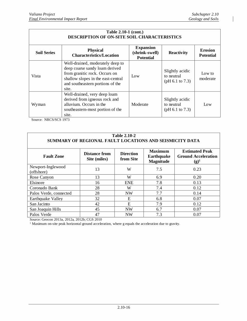
Valiano Project Subchapter 2.10
Final Environmental Impact Report Geology and Soils
2.10-16
Table 2.10-1 (cont.)
DESCRIPTION OF ON-SITE SOIL CHARACTERISTICS
Soil Series Physical
Characteristics/Location
Expansion
(shrink-swell)
Potential
Reactivity Erosion
Potential
Vista
Well-drained, moderately deep to
deep coarse sandy loam derived
from granitic rock. Occurs on
shallow slopes in the east-central
and southeastern portions of the
site.
Low
Slightly acidic
to neutral
(pH 6.1 to 7.3)
Low to
moderate
Wyman
Well-drained, very deep loam
derived from igneous rock and
alluvium. Occurs in the
southeastern-most portion of the
site.
Moderate
Slightly acidic
to neutral
(pH 6.1 to 7.3)
Low
Source: NRCS/SCS 1973
Table 2.10-2
SUMMARY OF REGIONAL FAULT LOCATIONS AND SEISMICITY DATA
Fault Zone Distance from
Site (miles)
Direction
from Site
Maximum
Earthquake
Magnitude
Estimated Peak
Ground Acceleration
(g)1
Newport-Inglewood
(offshore) 13 W 7.5 0.23
Rose Canyon 13 W 6.9 0.20
Elsinore 16 ENE 7.8 0.13
Coronado Bank 28 W 7.4 0.12
Palos Verde, connected 28 NW 7.7 0.14
Earthquake Valley 32 E 6.8 0.07
San Jacinto 42 E 7.9 0.12
San Joaquin Hills 45 NW 6.7 0.07
Palos Verde 47 NW 7.3 0.07 Source: Geocon 2013a, 2012a, 2012b; CGS 2010 1 Maximum on-site peak horizontal ground acceleration, where g equals the acceleration due to gravity.
&=
&=
&=
&=
&=
&=
&=
&=
&=
&=
&=
&=
&=
&=
Rincon MWDReservoir
7 Site
Calic
o Lan
e
Eden Valley Lane
Mount Whitney Road
Hill Valley Drive
Private Road
T-7
T-9
T-10
T-6
T-21
T-20
T-19
T-23
T-22
T-18
T-24T-36
T-35 T-17
T-25
T-26
T-34
T-15T-14
T-16
T-30
T-31T-32
T-29
T-28
T-27
T-33
T-37
T-39+
T-40
T-41
T-42
T-48
T-47
T-46
T-45 T-43T-13
T-12
T-3 T-2
T-5T-6
T-11
T-10 T-9
T-4
T-8+
T-1
T-7
T-50
T-49
SL-6
SL-3
SL-4
SL-5
SL-2
SL-1
AT-8
AT-9
AT-6
AT-5
AT-4
AT-3AT-10
AT-2B-4
B-1
B-2
B-3+
AT-1
Kgr
Kgr
Qal
Kgr
Kgr
Qal
Qc
Kgr
Qc
Qc/Kgr
Qc
Qc
Qal
Qc
Qc
Qal
Qc
Qc
QcQc
Qc
Qal
Qudf
Qudf
Qudf
Qal
Qc
Qal
Qal
Qc
Qudf
QudfQudf
QudfKgr
Qal
Kgr
Qudf
Qal
Qal
Qudf
Qudf
Qal
Eden Valley Lane
T-44
AT-7
T-38+
KgrKgr
Qal
Figure 2.10-1aVALIANO
Geologic MapI:\PRO
JECT
S\I\IP
Q\IPQ
-08_V
alian
o\Map
\ENV\
EIR\
Fig2-1
0-1a_
Geolo
gy.m
xd
IPQ-11
11/2
4/14 -
RK
0 400FeetN
Project Boundary&= Air Track Boring&= Hollow Stem Boring
AlluviumColluviumGranitic Rock*Undocumented FillFault ^Approximate Location of Geologic Contact ^Approximate Location of Proposed Canyon SubdrainApproximate Location of TrenchApproximate Location of Siesmic Traverse
QalQcKgr
Qudf
* Italicized where buried^ Dashed where buried Queried where uncertain+ Shallow perched groundwater was observed?
SL-1T-1
B-1AT-1
Calic
o Lan
e
Eden Valley Lane
Harmony Heights Road
Coun
try C
lub D
rive
Kauana Loa Drive
T-1
T-2
T-3
T-4
T-5
T-8
T-7
T-12T-9
T-10
T-6
T-11
T-21
T-20
T-19
T-23
T-22
T-18
SL-1SL-2
SL-3Kgr
Kgr
Mzu
Qal/Kgr
Qc/KgrQc/Kgr
Kgr
Qudf/Kgr
Qal
Qc
QalQc
Qudf/MzuMzu
QalQudf
Kgr
? ??
?
?
?
?
?
?
?
?
?
?
?
?
Figure 2.10-1bVALIANO
Geologic MapI:\PRO
JECT
S\I\IP
Q\IPQ
-08_V
alian
o\Map\
ENV\
EIR\
Fig2-1
0-1b_
Geolo
gy.m
xd
IPQ-11
04/2
8/14 -
RK
0 400FeetN
Project BoundaryAlluviumColluviumGranitic Rock*Metasedimentary and Metavolcanic Rock*Undocumented FillApproximate Location of Geologic Contact ^Approximate Location of Proposed Canyon SubdrainApproximate Location of TrenchApproximate Location of Siesmic Traverse
QalQcKgrMzuQudf
* Italicized where buried^ Dashed where buried Queried where uncertain?
SL-1T-1