final environmental assessment for ......final report 1-1 1.0 introduction and purpose and need this...
TRANSCRIPT

FINAL ENVIRONMENTAL ASSESSMENT
FOR CONVERSION OF VEHICLE BARRIERS
TO LANDING MAT FENCE
NACO, ARIZONA
October 2002
IMMIGRATION AND NATURALIZATION SERVICEWASHINGTON, D.C.


FINAL ENVIRONMENTAL ASSESSMENT for
Conversion of Vehicle Barriers to Landing Mat Fence Naco, Cochise County, Arizona
October 2002
Lead Agency: Immigration and Naturalization Service
Headquarters Facilities and Engineering 425 I Street NW
Washington, D.C. 20536
Responsible Official: Mr. Charles Parsons
Regional Environmental Officer INS Western Region
24000 Avila Road Laguna Niguel, CA 92677
Fax 949-360-2985
Prepared By: Gulf South Research Corporation
P.O. Box 83564 Baton Rouge, LA 70884
Naco Fence EA October 2002 Final Report ii
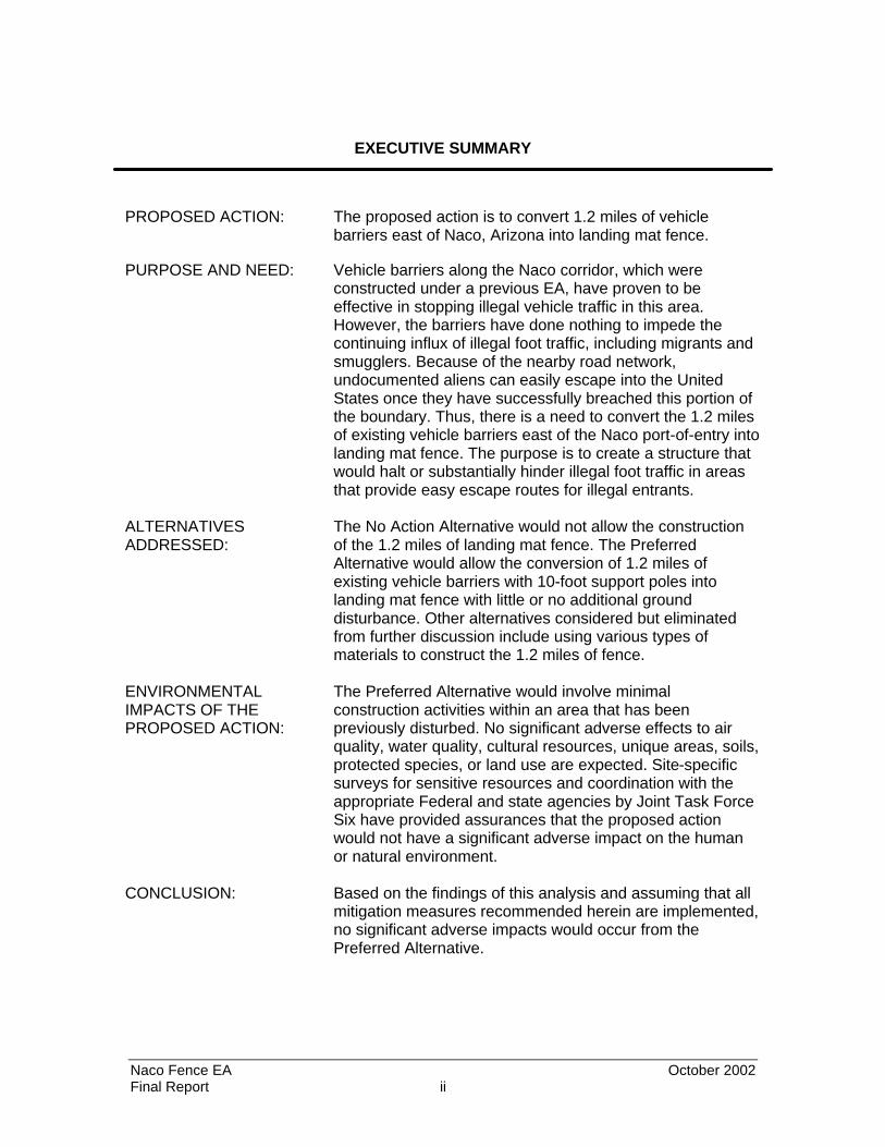
EXECUTIVE SUMMARY
PROPOSED ACTION: The proposed action is to convert 1.2 miles of vehicle barriers east of Naco, Arizona into landing mat fence.
PURPOSE AND NEED: Vehicle barriers along the Naco corridor, which were constructed under a previous EA, have proven to be effective in stopping illegal vehicle traffic in this area. However, the barriers have done nothing to impede the continuing influx of illegal foot traffic, including migrants and smugglers. Because of the nearby road network, undocumented aliens can easily escape into the United States once they have successfully breached this portion of the boundary. Thus, there is a need to convert the 1.2 miles of existing vehicle barriers east of the Naco port-of-entry into landing mat fence. The purpose is to create a structure that would halt or substantially hinder illegal foot traffic in areas that provide easy escape routes for illegal entrants.
ALTERNATIVES ADDRESSED:
The No Action Alternative would not allow the construction of the 1.2 miles of landing mat fence. The Preferred Alternative would allow the conversion of 1.2 miles of existing vehicle barriers with 10-foot support poles into landing mat fence with little or no additional ground disturbance. Other alternatives considered but eliminated from further discussion include using various types of materials to construct the 1.2 miles of fence.
ENVIRONMENTAL IMPACTS OF THE PROPOSED ACTION:
The Preferred Alternative would involve minimal construction activities within an area that has been previously disturbed. No significant adverse effects to air quality, water quality, cultural resources, unique areas, soils, protected species, or land use are expected. Site-specific surveys for sensitive resources and coordination with the appropriate Federal and state agencies by Joint Task Force Six have provided assurances that the proposed action would not have a significant adverse impact on the human or natural environment.
CONCLUSION: Based on the findings of this analysis and assuming that all mitigation measures recommended herein are implemented, no significant adverse impacts would occur from the Preferred Alternative.

Naco Fence EA October 2002 Final Report iii
TABLE OF CONTENTS
1.0 INTRODUCTION AND PURPOSE AND NEED................................................1-1 1.1 Background ...................................................................................................... 1-1 1.1.1 INS Organization...................................................................................1-1 1.1.2 Naco Station .........................................................................................1-3 1.1.3 Regulatory Authority .............................................................................1-3 1.2 Purpose and Need ...........................................................................................1-4 1.3 Location of the Proposed Action.......................................................................1-5 1.4 Report Organization .........................................................................................1-5 2.0 ALTERNATIVES..............................................................................................2-1 2.1 No Action Alternatives ......................................................................................2-1 2.2 The Preferred Alternative – Landing Mat Fence ...............................................2-1 2.3 Alternatives Considered but Eliminated from Further Evaluation ......................2-2 2.3.1 Conventional Fence Alternative ............................................................2-4 2.3.2 Specialty Fence Alternative...................................................................2-4 2.4 Summary..........................................................................................................2-6 3.0 AFFECTED ENVIRONMENT ...........................................................................3-1 3.1 Land Use..........................................................................................................3-1 3.1.1 Mining Operations.................................................................................3-1 3.2 Soils and Prime Farmland ................................................................................3-2 3.2.1 Soils......................................................................................................3-2 3.2.1.1 Hydric Soils ...............................................................................3-2 3.2.2 Prime Farmland ....................................................................................3-2 3.3 Vegetation ........................................................................................................3-2 3.4 Wildlife Communities ........................................................................................3-3 3.5 Unique or Sensitive Areas ................................................................................3-4 3.6 Protected Species and Critical Habitats............................................................3-4 3.6.1 Federal .................................................................................................3-6 3.6.2 Critical Habitat .................................................................................... 3-10 3.6.3 State ................................................................................................... 3-10 3.7 Cultural Resources......................................................................................... 3-11 3.8 Air Quality ...................................................................................................... 3-11 3.9 Water Resources............................................................................................ 3-13 3.9.1 Waters of the U.S. and Wetlands ........................................................ 3-13 3.10 Socioeconomics ............................................................................................. 3-14 3.11 Noise.............................................................................................................. 3-14 4.0 ENVIRONMENTAL CONSEQUENCES ...........................................................4-1 4.1 Land Use..........................................................................................................4-1 4.1.1 No Action Alternative ............................................................................4-1 4.1.2 Preferred Alternative .............................................................................4-1 4.2 Soils and Prime Farmland ................................................................................4-1 4.2.1 No Action Alternative ............................................................................4-1 4.2.2 Preferred Alternative .............................................................................4-1 4.3 Vegetation ........................................................................................................4-2 4.3.1 No Action Alternative ............................................................................4-2 4.3.2 Preferred Alternative .............................................................................4-2
Naco Fence EA October 2002 Final Report iv
4.4 Wildlife .............................................................................................................4-3 4.4.1 No Action Alternative ............................................................................4-3 4.4.2 Preferred Alternative .............................................................................4-3 4.5 Unique or Sensitive Areas ................................................................................4-3 4.6 Protected Species and Critical Habitats............................................................4-3 4.6.1 No Action Alternative ............................................................................4-3 4.6.2 Preferred Alternative .............................................................................4-3 4.7 Cultural Resources...........................................................................................4-4 4.7.1 No Action Alternative ............................................................................4-4 4.7.2 Preferred Alternative .............................................................................4-4 4.8 Air Quality.........................................................................................................4-5 4.8.1 No Action Alternative ............................................................................4-5 4.8.2 Preferred Alternative .............................................................................4-5 4.9 Water Resources..............................................................................................4-5 4.9.1 No Action Alternative ............................................................................4-5 4.9.2 Preferred Alternative .............................................................................4-5 4.10 Socioeconomics ...............................................................................................4-5 4.10.1 No Action Alternative ............................................................................4-5 4.10.2 Preferred Alternative .............................................................................4-6 4.10.3 Environmental Justice...........................................................................4-6 4.11 Noise Effects ....................................................................................................4-7 4.11.1 No Action Alternative ............................................................................4-7 4.11.2 Preferred Alternative .............................................................................4-7 4.12 Cumulative Effects............................................................................................4-8 4.12.1 No Action Alternative ............................................................................4-8 4.12.2 Preferred Alternative ........................................................................... 4-11 5.0 ENVIRONMENTAL DESIGN MEASURES.......................................................5-1 5.1 Air Quality.........................................................................................................5-1 6.0 PUBLIC INVOLVEMENT .................................................................................6-1 6.1 Agency Coordination ........................................................................................6-1 6.2 Public Review ..................................................................................................6-1 6.3 Comments and Responses ..............................................................................6-3 7.0 REFERENCES.................................................................................................7-1 8.0 ACRONYMS ....................................................................................................8-1 9.0 LIST OF PREPARERS ....................................................................................9-1
LIST OF EXHIBITS
Exhibit 6-1: Notice of Availability ..................................................................................6-2
LIST OF FIGURES
Figure 1-1: Existing Infrastructure East of Naco POE...................................................1-6

Naco Fence EA October 2002 Final Report v
LIST OF PHOTOGRAPHS
Photograph 1: Landing mat fence ................................................................................2-1 Photograph 2: 0.2 mile of low vehicle barriers..............................................................2-3 Photograph 3: Trenching for vehicle barriers with vertical support poles ......................2-3 Photograph 4: Existing vehicle barriers with 10’ vertical support poles........................ 2-3 Photograph 5: Bollard style fence................................................................................ 2-4 Photograph 6: Sandia style fence ................................................................................ 2-5 Photograph 7: Picket style fence..................................................................................2-5
LIST OF TABLES
Table 2-1: Alternative Matrix ........................................................................................2-6 Table 2-2: Summary Matrix of Potential Impacts ..........................................................2-7 Table 3-1: Federally Listed, Proposed, and Candidate Species Potentially Occurring within Cochise County, Arizona ........................................................................3-7 Table 3-2: National Ambient Air Quality Standards .................................................... 3-12

SECTION 1.0INTRODUCTION AND PURPOSE AND NEED

Naco Fence EA October 2002 Final Report 1-1
1.0 INTRODUCTION AND PURPOSE AND NEED
This Final Environmental Assessment (EA) addresses the potential for effects, beneficial
and adverse, of the Immigration and Naturalization Service (INS) and U.S. Border Patrol
(USBP) proposed fence construction activities within the USBP Naco Station area of
operation (AO). This EA evaluates the conversion of 1.2 miles of existing vehicle barriers
to landing mat fence as part of the INS and USBP infrastructure projects within the Naco
AO. This EA is tiered from two documents: the Final Environmental Assessment for
Infrastructure within U.S. Border Patrol Naco-Douglas Corridor, Cochise County, Arizona
(INS 2000) and the Final Environmental Assessment for Joint Task Force Six (JTF-6)
Proposed Fence and Road Improvement Project, Naco, Cochise County, Arizona
(USACE 2000).
This EA was prepared in accordance with the National Environmental Policy Act (NEPA)
of 1969, the President’s Council on Environmental Quality (CEQ) Regulations for the
Implementation of the NEPA, as well as the INS’s Procedures for Implementing NEPA
(28 CFR 61).
1.1 Background
1.1.1 INS Organization
The INS has the responsibility to regulate and control immigration into the United States.
In 1924, the U.S. Congress created the USBP to be the law enforcement arm of the INS.
The USBP’s primary function is to detect and deter the unlawful entry of undocumented
aliens (UDAs) and smuggling along the United States’ land borders and between the
ports-of-entry (POE). With the increase in illegal drug trafficking, the USBP also has
become the leader for drug interdiction between land POEs. Since 1980, an average of
150,000 immigrants have been naturalized every year. At the same time, however, illegal
aliens have become a significant issue. Apprehension rates for INS are currently
averaging more than 1.5 million illegal aliens throughout the country. At present, the INS
estimates that there are seven to nine million illegal aliens in the United States. Other
studies have indicated higher numbers, closer to 10 million.
Naco Fence EA October 2002 Final Report 1-2
The INS has reported that the U.S.-Mexico border is breached more than any other
international border in the world. It is a large, diverse, and difficult boundary to effectively
enforce without the use of dedicated tactical infrastructure (fences, lights, roads,
cameras, etc.).
Prior to the early 1990s, there was less awareness of southwest border issues and less
national attention was given to illegal trans-boundary activity than is currently
attributable. As a result, the USBP’s growth was nominal, funding for enforcement efforts
fell short, and the USBP functioned under severe constraints. Events over the last
decade, however, related to illegal immigration and narcotics smuggling have increased
the nation’s awareness and generated substantial interest in controlling the U.S.-Mexico
border. This has resulted in increased funding and staffing, and has also created new
opportunities in the development of proactive border control strategies as demonstrated
in patrol and enforcement operations throughout the southwest border area (e.g.,
Operations Gatekeeper, Hold-the-Line, Safeguard, and Rio Grande).
The anti-terrorism role of the INS has always been an important function to the agency;
however, since the September 11, 2001 terrorist attack on the United States, this role
has been increased and is now more important than ever. This increased function to
fight terrorism requires more vigilance at the POEs and all areas along the borders. All
enforcement activities and subsequent infrastructure and technological improvements,
such as roads, fencing, remote video surveillance (RVS) systems, and lighting, are
necessary elements in securing our borders from illegal entry.
Past enforcement strategies were reactive, and because little emphasis was placed on
deterring illegal crossing, it diminished the importance of infrastructure (e.g., lights and
fences) along the U.S.-Mexico border. Instead, the USBP’s efforts focused primarily on
making apprehensions after the international boundary was breached. This strategy
utilized the “element of surprise” by deploying their limited resources away from the
border in concealed positions. However, as illicit trafficking continued to increase, the
area that the USBP was required to patrol also increased. The USBP’s inability to deter
or contain illegal migration at the border resulted in an increase in the geographic
footprint, and subsequent environmental impacts, of illegal migration patterns.

Naco Fence EA October 2002 Final Report 1-3
During recent years, the USBP has significantly increased its emphasis on deterrence.
Deterrence is achieved only when the USBP has the ability to create and convey the
immediate, credible, and absolute certainty of detection and apprehension. As such,
tactical infrastructure components, such as fences, are a critical element in the current
enforcement strategy. Developing trends such as the continued urbanization and
industrialization of the immediate border, the recognition of environmental preservation
concerns, and the increase of criminal trans-boundary activities (including trafficking in
people and drugs and terrorist acts) continue to pose a border enforcement challenge
and compound the need for tactical infrastructure.
1.1.2 Naco Station
The Naco Station AO is located within Cochise County and covers approximately 1,600
square miles. The station AO includes 30 miles of the international border and the towns
of Naco, Bisbee, Tombstone, Sierra Vista, Warren, Hereford, Palominas, and Huachuca.
There are currently 224 USBP agents assigned to the station. The geographical terrain
of the area is desert with rolling hills covered with brush thickets and numerous north-
south trending washes. The approximate elevation of the station is 4,800 feet above
mean sea level (msl).
1.1.3 Regulatory Authority
The primary sources of authority granted to officers of the INS are the Immigration and
Nationality Act (INA), found in Title 8 of the United States Code (USC), and other
statutes relating to the immigration and naturalization of aliens. Secondary sources of
authority are administrative regulations implementing those statutes, primarily those
found in Title 8 of the Code of Federal Regulations (8 CFR Section 287), judicial
decisions, and administrative decisions of the Board of Immigration Appeals. In addition,
the Illegal Immigration Reform and Immigrant Responsibility Act (IIRIRA) mandates INS
to acquire and/or improve equipment and technology along the border, hire and train
new agents for the border region, and develop effective border enforcement strategies.
Subject to constitutional limitations, INS officers may exercise the authority granted to
them in the INA. The statutory provisions related to enforcement authority are found in
Sections 287(a), 287(b), 287(c), and 287(e) [8 USC § 1357(a,b,c,e)]; Section 235(a) [8
USC § 1225]; Sections 274(b) and 274(c) [8 USC § 1324(b,c)]; Section 274(a) [8 USC §

Naco Fence EA October 2002 Final Report 1-4
1324(a)]; and Section 274(c) [8 USC § 1324(c)] of the INA. Other statutory sources of
authority are Title 18 of the United States Code (18 USC), which has several provisions
that specifically relate to enforcement of the immigration and nationality laws; Title 19 [19
USC § 1401(i)], relating to U.S. Customs Service cross-designation of INS officers; and
Title 21 [21 USC § 878], relating to Drug Enforcement Agency cross-designation of INS
officers.
1.2 Purpose and Need
The combination of sound infrastructure (e.g., roads, fences, barriers, and technological
components) and adequate resources (e.g., vehicles, field agents, support personnel,
etc.) is essential for the effective enforcement of the border strategy and integral to the
success of the USBP to gain, maintain, and extend control of the border.
Border fences have proven to be an effective deterrent in numerous areas (e.g., San
Diego, Naco, Nogales, and Tecate), even though a single fence can be breached, since
USBP agents cannot protect the south side of the fence. In fact, UDA apprehensions in
the Naco AO have fallen from 113,287 in fiscal year 2000 to 36,900 by May 2002.
Fences are typically constructed in urban or developed areas, particularly around legal
POEs. Military surplus steel landing mat fences have been the type of fence most
commonly constructed along the border. However, numerous other styles, including
bollard, Sandia, and steel picket fences, have also been used. These fences are
generally 10-14 feet high and usually constructed within six feet of the U.S.-Mexico
border. Fence designs can vary depending upon the presence of other natural or man-
made physical barriers, local terrain, and the USBP’s enforcement strategy.
Vehicle barriers typically consist of 4- to 5-inch diameter metal pipe approximately three
feet high to prevent vehicles from crossing the border at selected areas. They are
usually constructed along the southern edge of existing roads, particularly roads that are
adjacent to the U.S.-Mexico border. As the name implies, vehicle barriers are designed
to impede illegal vehicle entry; however, they do not preclude pedestrian or wildlife
movement.

Naco Fence EA October 2002 Final Report 1-5
The vehicle barriers, which were addressed under a previous EA (USACE 2000), have
proven to be effective in stopping illegal vehicle traffic along the 1.2-mile corridor.
However, the barriers have done nothing to impede the continuing influx of illegal foot
traffic, including migrants and smugglers. Because of the nearby road network, UDAs
can easily escape into the United States once they have successfully breached this
portion of the border. Thus, there is a need to convert 1.2 miles of existing vehicle
barriers east of the Naco POE into landing mat fence. The purpose is to create a
structure that would halt or substantially hinder illegal foot traffic in areas that provide
easy escape routes for illegal entrants.
1.3 Location of the Proposed Action
The proposed action is located in Cochise County near the town of Naco, Arizona
approximately 100 miles southeast of Tucson. Naco is located on the U.S.-Mexico border
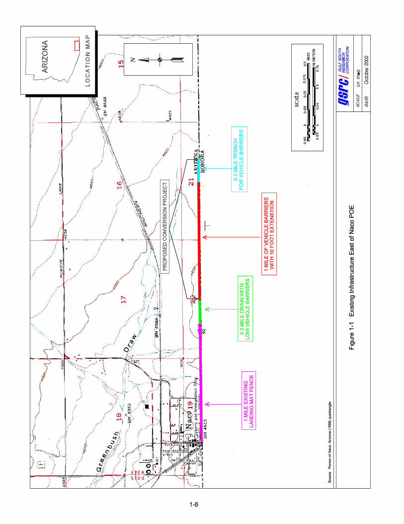
across from Naco, Sonora, Mexico, and is a legal POE. Currently, about 2.3 miles of
various infrastructure have been built along the border east of the Naco POE (Figure 1-1).
The proposed action would take place along the eastern-most 1.2-mile section shown in
Figure 1-1.
1.4 Report Organization
This report is organized into nine major sections including this introduction with the
description of the purpose, need, and location of the proposed project. Section 2.0
describes all alternatives considered for the project. Section 3.0 discusses the
environmental features potentially affected by the project, while Section 4.0 discusses
the environmental consequences for each of the viable alternatives. Mitigation measures
are discussed in Section 5.0 and public involvement is addressed in Section 6.0.
Sections 7.0, 8.0, and 9.0 present a list of the references cited in the document, a list of
acronyms and abbreviations, and a list of the persons involved in the preparation of this
document, respectively. Appendix A includes supporting documents of the public
involvement program, such as the notice of availability and public comment letters. Other
supporting documents can be found in the Environmental Assessment completed for
U.S. Border Patrol’s Infrastructure along the Naco-Douglas Corridor in Cochise County,
Arizona (INS 2000) and the Environmental Assessment for JTF-6 Proposed Fence and
Road Improvement Project, Naco, Cochise County, Arizona (USACE 2000).
SECTION 2.0ALTERNATIVES

Naco Fence EA October 2002 Final Report 2-1
Photograph 1. Landing mat fence
2.0 ALTERNATIVES
The purpose of this section is to describe the alternatives that were considered during
the preparation of the EA, relative to their ability to satisfy the purpose and need. Cost
and maintenance requirements were also considered in the selection of alternatives.
Four alternatives will be addressed: (1) No Action Alternative; (2) Preferred Alternative;
(3) Conventional Fence Alternative; and (4) Specialty Fence Alternative. Each of these
alternatives is discussed below.
2.1 No Action Alternative
The No Action Alternative would require leaving the vehicle barriers in place and not
continuing the landing mat fence for 1.2 miles. While border vehicle barriers have proven
to be an effective deterrent in illegal vehicular drive-throughs, they do not deter illegal
immigrants from climbing over or under them. The No Action Alternative would not
provide an increased deterrence of illegal foot entry nor expand the window of
opportunity for USBP agents to detect illegal entry attempts.
2.2 The Preferred Alternative – Landing Mat Fence
The Preferred Alternative is to construct approximately 1.2 miles of steel landing mat
panel fencing (Photograph 1) along the
existing vehicle barriers east of Naco,
Arizona. The proposed fence would start
where the vehicle barriers with tall vertical
supports begin (approximately 0.2 mile
east of the existing landing mat fence)
and continue east 1.2 miles. An existing
border road is adjacent to and parallel
with the vehicle barrier and would be
used during the construction for the
landing mat fence. Thus, no new roads or
road upgrades would be required for the proposed action. The 0.2-mile section located
between the end of the existing landing mat fence and beginning of the proposed

Naco Fence EA October 2002 Final Report 2-2
landing mat fence is a small drainage area (see Figure 1-1). This area currently has low
vehicle barriers (Photograph 2). If fencing were to be erected in this area, it would most
likely be a bollard style fence to allow water to flow and would require a separate NEPA
document.
Currently, of the 1.2 miles of proposed landing mat fence, 1.0 mile has the vertical
supports in place while the remaining 0.2 mile of supports have not yet been
constructed. Trenches (Photograph 3) for placement of the support barriers are in place
and the work is expected to be completed in the near future. The trenching and
installation of the vertical support barriers was covered under a previous NEPA
document (USACE 2000).
The proposed steel landing mat fence would be constructed with surplus military
supplies similar to the existing fence adjacent to the POE at a cost of approximately
$5,000 per mile. The fence would be erected to approximately 10 feet of height during
the initial construction phase. It is also the USBP’s intent to add an approximate 5-foot
vertical, expanded wire mesh panel extension to the top of the fence in the future. Each
landing mat panel would be welded to the next to form a solid fence. The landing mat
panels would be joined directly to the vehicle barriers; thus, very little, if any, additional
ground disturbance would be required. Vertical support poles (Photograph 4) at a height
of 10 feet are currently in place to provide additional support for the landing mat fence;
however, additional support poles, if needed, would be installed using an auger and the
holes would be grouted with concrete. This alternative would substantially impede illegal
foot and vehicle traffic within the area with minimal cost and environmental impacts.
2.3 Alternatives Considered but Eliminated from Further Evaluation
Other types of fencing materials/fence designs were considered during the preparation
of this EA. However, since they did not satisfy the purpose and need to provide a
substantial barrier to illegal foot traffic or were too costly or time consuming to install or
maintain, these alternative designs were eliminated from further consideration. Two
major categories of fences (i.e., conventional and specialty) were considered, as
described below.

Naco Fence EA October 2002 Final Report 2-3
Photograph 3
Trenching for vehicle barriers with vertical support poles
Photograph 4 Existing vehicle barriers with
10’ vertical support poles
Photograph 2 0.2 mile of low vehicle barrier

Naco Fence EA October 2002 Final Report 2-4
2.3.1 Conventional Fence Alternative
Conventional fence building materials, such as barbed wire and chain link, have been
considered by the USBP. These materials are not excessively expensive when
compared to the specialty fences described below, but still cost a great deal more than
the landing mat option. In addition, these materials are not considered to be as effective
as landing mat panels in satisfying the purpose and need. Chain link fencing costs
approximately $130,000 per mile and requires a high level of maintenance, and is not
resistant to cutting or vandalism. Barbed wire fencing would be the least effective and is
easily traversed without the necessity of cutting the fence, although the cost is
approximately $40,000 per mile. Although fences built from these materials may offer
some level of deterrence to illegal entrance, they would require constant maintenance
due to the effects of vandalism and exposure to the elements. Furthermore, the
environmental impacts from the construction of these types of fences would be similar to
those produced by construction of a landing mat panel fence. Additionally, landing mat
panel fences would require less maintenance and as a result, less maintenance impacts
and costs. Thus, these designs were eliminated from further consideration.
2.3.2 Specialty Fence Alternative
The bollard fence (Photograph 5) consists of a double row of 10- to 15-foot high steel
pipe poles, approximately six inches in diameter, placed on 8.5-inch centers. The pipes
would be filled with concrete for added strength and security. The two rows are offset,
such that the gaps between the poles would be filled by the poles of the other row. A
concrete footer is required to anchor the poles – approximately 20 inches wide and three
feet deep. This type of fence is
normally only used in areas with
flowing water that would damage
other types of fences. It is the most
expensive to construct, costing
approximately $1,000,000 per mile.
Therefore, this type of fence was
eliminated from further
consideration for this 1.2-mile
project area.
Photograph 5 Bollard style fence

Naco Fence EA October 2002 Final Report 2-5
Sandia fences (Photograph 6)
have been used in other areas
along the border. The current
standard design consists of
vertical secura metal mesh panels
attached to 16- foot steel poles.
Additional 6-foot panels are
secured to the top panels at an
angle of 45 degrees toward the
south. The poles would be
anchored to a 12-inch wide by 4-
foot deep concrete footing that runs the length of the proposed fence. Generally, this
type of fence has been used as a secondary fence behind the landing mat panel fence
or in maximum-security situations because of the high construction costs (approximately
$200,000/mile) and high maintenance costs if subjected to vandalism. The
environmental impacts from construction of this type of fence are greater than the
preferred landing mat panel fence due to the required ground disturbance; therefore this
design was eliminated from further consideration.
Decorative picket style fences
(Photograph 7) have been
used (e.g., near the Douglas
POE). The intended use of
picket fences is for aesthetic
reasons rather than structural
or cost effectiveness. This
fence has only been used in
an urban setting due to the
high cost of construction
(approximately $200,000/mile)
and the relative low durability
of this design. Environmental impacts resulting from construction of this type of fence
would be greater than the Preferred Alternative since the picket fence could not be
Photograph 6 Sandia style fence
Photograph 7 Picket style fence

Naco Fence EA October 2002 Final Report 2-6
applied directly to the vehicle barrier and additional ground disturbance would be
required.
2.4 Summary
Two alternatives were carried forward for analysis: No Action Alternative and Preferred
Alternative. Other fence designs were considered but eliminated due to operational or
cost constraints. A summary of the alternatives, in comparison to the purpose and need
for the action, is presented in Table 2-1.
Table 2-1: Alternative Matrix
Fence Purpose and Need Requirements
No Action Landing
Mat Fence
Chain Link
Barbed wire
Specialty
Effective in deterring foot traffic from illegal migrants and drug smugglers
No Yes Maybe No Yes
Reduce number of easy escape routes for illegal entrants
No Yes No No Yes
Prevent vehicular drive-throughs Yes Yes Maybe No Yes
Cost per mile NA $5,000 $130,000 $40,000 $200,000+
Due to the disturbed nature of the project corridor and the fact that the vehicle barrier is
already in place, negligible impacts to the human and natural environment would occur
as a result of the Preferred Alternative (Table 2-2). Conversion of the vehicle barrier to
landing mat fence would have an effect on migration patterns of larger mammals;
however, these effects are also considered to be insignificant since the surrounding area
does not support expansive populations of large mammals that would be susceptible to
slight, long-term shifts in genetic variability.

Naco Fence EA October 2002 Final Report 2-7
Table 2-2: Summary Matrix of Potential Impacts
Affected Environment No Action Alternative Preferred Alternative – Landing Mat Fence
Land Use No impacts Land use would remain the same as it is now
Soils and Prime Farmlands No impacts No additional soil disturbance would be required
Vegetation UDA foot traffic would continue to disturb vegetation in the project region
The project site has been previously disturbed and essentially void of vegetation
Wildlife Communities
UDA foot traffic would continue to disturb wildlife species and their habitats in the project region
Proposed project could interfere with wildlife migration patterns; however, the project area is highly disturbed and not suitable for wildlife species that would be most affected by fence
Unique and Sensitive Areas No impacts No impacts
Protected Species and Critical Habitat
UDA foot traffic would continue to disturb protected species and designated critical habitats in the project region
No protected species were observed within the project site; there are no designated critical habitats within the project site
Cultural Resources No impacts
No additional ground disturbance would be required; therefore, no impacts to cultural resources
Air Quality No impacts
Short-term increase in emissions from equipment required for proposed project; any increase is expected to be temporary
Water Resources No Impacts No impacts
Socioeconomics
Continued UDA and drug smuggling foot traffic in urban/developed areas near the POE
Improved socioeconomics in surrounding communities due to less UDA and drug smuggling activities
Noise No additional impacts
Short-term increase in noise from equipment required for proposed project; any increase is expected to be temporary
SECTION 3.0AFFECTED ENVIRONMENT
Naco Fence EA October 2002 Final Report 3-1
3.0 AFFECTED ENVIRONMENT
3.1 Land Use
The total area of Cochise County is 6,170 square miles. The 2000 census estimated the
population at 117,755, with a population density of 19.1 persons per square mile (U.S.
Census Bureau 2001). The largest land use category for the county is in the private and
corporate ownership (42%). The principal land use outside the urban areas is rangeland
and agriculture (cotton, alfalfa, barley, corn, and vegetables). The Federal government
controls approximately 841,000 acres (21%), with the U.S. Forest Service (USFS)
managing approximately 490,000 acres (12%) of the land in the county. The majority of
the USFS land is the multiple-use Coronado National Forest. The U.S. Fish and Wildlife
Service (USFWS) manages the San Bernardino National Wildlife Refuge within Cochise
County. The Bureau of Land Management (BLM) manages approximately 350,000 acres
(9%). The BLM land includes the Chiricahua National Monument, the San Pedro
Riparian National Conservation Area, and numerous multiple use areas used primarily
for grazing. The State of Arizona manages approximately 1,368,000 acres (34%), which
is primarily maintained for recreation, historical, and natural uses.
The project region has three small to medium sized urban areas. According to the U.S.
Census Bureau (2001), the primary urban areas and their 2000 populations are: Douglas
(14,312), Bisbee (6,090), and Naco (833). More detailed information regarding land use
in the project region can be found in the EA completed for USBP’s infrastructure along
the Naco-Douglas corridor in Cochise County, Arizona (INS 2000) and the EA for JTF-6
Proposed Fence and Road Improvement Project, Naco, Cochise County, Arizona
(USACE 2000), and is incorporated herein by reference.
3.1.1 Mining Operations
Copper mining is an important industry in Arizona. In 1999, activities of the Arizona
copper industry occurred on 187,900 acres of the state’s 72,960,000 acres (Arizona
Mining Association 2000). No mines are presently being operated in Cochise County.
However, Bisbee operates several tourist industries based on past mining in the area,
such as Bisbee Mining and Historical Museum and Queen Mine Tours.
Naco Fence EA October 2002 Final Report 3-2
3.2 Soils And Prime Farmland
3.2.1 Soils
Arizona has a diverse assortment of soil types throughout the state with variations in
depth, texture, chemical properties, and appropriate land uses. This diversity is directly
related to regional differences in climate, parent material, topography, and erosion
actions. The predominant soil association found within the project area is the Nickel-
Latene-Pinaleno Association (Hendricks 1985).
The Nickel-Latene-Pinaleno Association is found in the central portion of the Naco
Station and covers much of the area surrounding the POE. It consists of very deep and
shallow, well-drained soils that formed in alluvium. It is found on floodplains and fan
terraces at slopes of zero to 20 percent at elevations from 2,000 to 5,500 feet msl. More
detailed information regarding the soils in the project area is contained in previous EAs
(INS 2000; USACE 2000), and is incorporated herein by reference.
3.2.1.1 Hydric Soils
There are no hydric soils located within the project area (Wilson 2000; Bemis 2000).
3.2.2 Prime Farmland
There are no prime or unique farmlands located within the project area. Prime farmlands
are classified as Category 1 soils that occur mainly within the San Pedro Valley. Soils
within the project area are not considered unique because they require irrigation to be
arable (Bemis 2000).
3.3 Vegetation
Biological resources include native plants in the region around the proposed project
area. The proposed project region supports a plant community defined as semi-desert
grassland, a perennial grass-scrub community that is usually located between desert
scrub and higher elevation plant communities (Brown 1994). This habitat type is found in
southeastern Arizona, southwestern New Mexico, and northern Mexico between
elevations of 4,000 and 8,000 feet msl and receives an annual rainfall between 11 and
17 inches per year.

Naco Fence EA October 2002 Final Report 3-3
Semi-desert grassland is found in the valley areas of Cochise and eastern Pima
counties. This vegetation type is dominated by grama grasses (Bouteloua spp.), velvet
mesquite (Prosopis velutina), Lehmann lovegrass (Eragrostis lehmanniana), and Arizona
cottontop (Digitaria californica). Other species in this community observed during the
November 1999 site visit include squawbush (Rhus trilobata), desert broom (Baccharis
sarothroides), broom snakeweed (Gutierrezia sarothrae), Parry’s agave (Agave parryi),
and some oak species (Quercus sp.) (USACE 2000). More detailed information on
vegetation in the project area can be found in previous EAs (INS 2000; USACE 2000) and
is incorporated herein by reference.
A field reconnaissance survey was performed along the 1.2-mile corridor in March 2002
and a pedestrian survey of the entire Naco Station was performed in April 2002. These
biological surveys were conducted in an effort to inventory biological resources in the
proposed project area and evaluate the potential effects of the alternatives on these
resources.
Based on these recent field surveys, the semi-desert grassland designation is consistent
throughout the project region. Dominant vegetation observed adjacent to the existing road
and fence during the surveys was white thorn acacia (Acacia constricta), mesquite,
Lehmann lovegrass, and Plains lovegrass (Eragrostis intermedia). Less common plants
observed in the area were mormon tea (Ephedra aspera), soaptree yucca (Yucca elata),
Christmas cholla (Opuntia leptocaulis), desert holly (Acourtia nana), and desert sumac
(Rhus microphylla). The corridor where the proposed action would occur is in a disturbed
state due to recent fence and road work along the border, which was addressed in the
JTF-6 Fence EA (USACE 2000).
3.4 Wildlife Communities
The native fauna of southeastern Arizona, which encompass Cochise County, include
approximately 370 bird species, 109 mammals, 23 amphibians, and 72 reptiles. The bird
population is dominated by sparrows and towhees (35 species); wood warblers (32
species); swans, geese, and ducks (31 species); tyrant flycatchers (30 species); and
sandpipers and phalaropes (26 species). Bird species diversity is highest in the spring

Naco Fence EA October 2002 Final Report 3-4
and fall when neotropical migrants (i.e., flycatchers and warblers) pass through on their
way to summer breeding or wintering grounds, and in the winter when summer resident
birds (i.e., robins, kinglets, and sparrows) from the northern U.S. and Canada arrive to
winter in the area. The majority of the mammal species found in the area are bats and
rodents (i.e., mice, rats, and squirrels). Rodents, such as pocket mice and kangaroo
rats, are the most commonly encountered. Of the 23 amphibian species that inhabit
southeastern Arizona, spadefoot toads and true toads are dominant and the most
widespread. Iguanid lizards, colubrid snakes, and whiptails are the most common
reptiles in the area. The types of wildlife commonly occurring in Cochise County are
listed in Appendix A of the EA for Infrastructure within USBP Naco-Douglas Corridor,
Cochise County, Arizona (INS 2000). More information on fauna within the project region
can be found in the EA for JTF-6 Proposed Fence and Road Improvement Project
Douglas, Cochise County, Arizona (USACE 2000).
A field reconnaissance survey was performed along the 1.2-mile corridor in March 2002
and pedestrian surveys were performed in April 2002 for the entire Naco Station. Common
fauna species observed during the April 2002 surveys of the station were black-tailed
jackrabbit, black-throated sparrow, white-winged dove, western kingbird, roadrunner,
scaled quail, Gambel’s quail, and verdin. No species were observed at the project site in
March 2002.
3.5 Unique or Sensitive Areas
Several unique or sensitive areas are found in or near Cochise County, Arizona. The
closest one to the project area is the San Pedro Riparian National Conservation Area.
This conservation area begins approximately 17 miles west of the project area.
3.6 Protected Species and Critical Habitats
The Endangered Species Act (ESA) [16 U.S.C. 1531 et. seq.] of 1973, as amended, was
enacted to provide a program for the preservation of endangered and threatened species
and to provide protection for the ecosystems upon which these species depend for their
survival. All Federal agencies are required to implement protection programs for
designated species and to use their authorities to further the purposes of the act.

Naco Fence EA October 2002 Final Report 3-5
Responsibility for the identification of a threatened or endangered species and
development of any potential recovery plan lies with the Secretary of the Interior and the
Secretary of Commerce.
The USFWS is the primary agency responsible for implementing the ESA, and is
responsible for bird, terrestrial, and freshwater species. The USFWS responsibilities under
the ESA include: (1) the identification of threatened and endangered species; (2) the
identification of critical habitats for listed species; (3) implementation of research on, and
recovery efforts for, these species; and (4) consultation with other Federal agencies
concerning measures to avoid harm to listed species.
An endangered species is a species in danger of extinction throughout all or a significant
portion of its range. A threatened species is a species likely to become endangered
within the foreseeable future throughout all or a significant portion of its range. Proposed
species are those that have been formally submitted to Congress for official listing as
threatened or endangered. Species may be considered endangered or threatened when
any of the five following criteria occurs: (1) current/imminent destruction, modification, or
curtailment of their habitat or range; (2) overuse of the species for commercial,
recreational, scientific, or educational purposes; (3) disease or predation; (4) inadequacy
of existing regulatory mechanisms; and (5) other natural or human-induced factors affect
continued existence.
In addition, the USFWS has identified species that are candidates for listing as a result
of identified threats to their continued existence. The candidate designation includes
those species for which the USFWS has sufficient information to support proposals to list
as endangered or threatened under ESA. However, proposed rules have not yet been
issued because such actions are precluded at present by other listing activity.
The ESA also calls for the conservation of what is termed Critical Habitat - the areas of
land, water, and air space that an endangered species needs for survival. Critical habitat
also includes such things as food and water, breeding sites, cover or shelter, and sufficient
habitat area to provide for normal population growth and behavior. One of the primary
threats to many species is the destruction or modification of essential habitat by
uncontrolled land and water development.

Naco Fence EA October 2002 Final Report 3-6
3.6.1 Federal
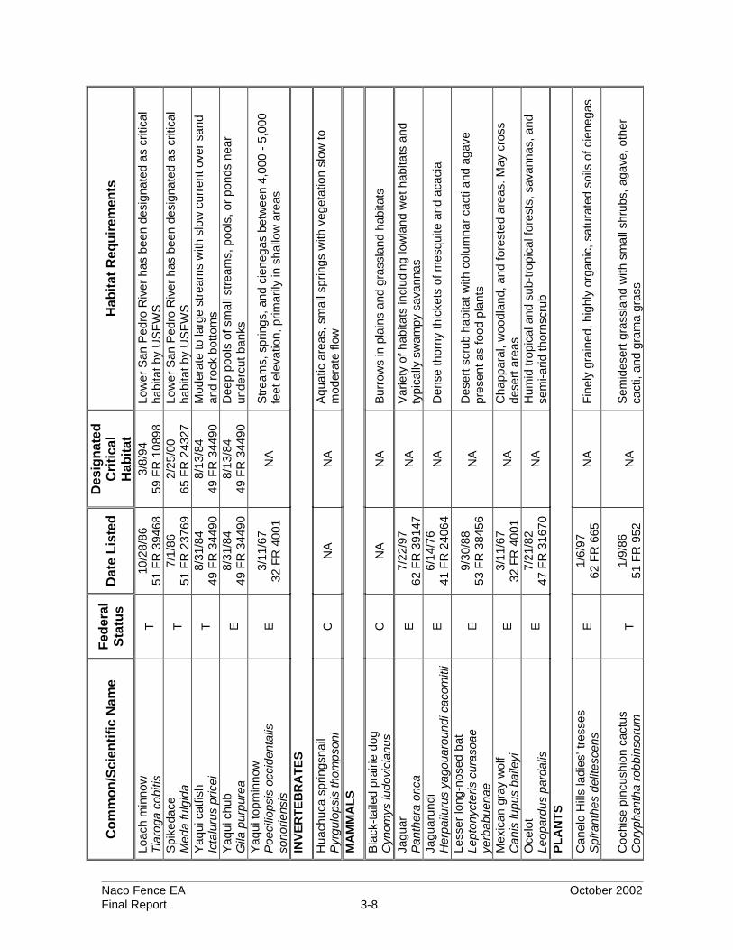
A total of 31 Federally endangered, threatened, proposed threatened, and candidate
species occur within Cochise County, Arizona (USFWS 2001). A total of 16 species are
listed as endangered, eight as threatened, two as proposed threatened, and five as
candidate (Table 3-1). This information was taken from a recently published document
for a project near Douglas, Arizona (approximately 20 miles to the east of Naco, AZ) and
the coordination letter can be found in Appendix B of that document (INS 2002). USFWS
coordination for the original barrier project was made under the EA for JTF-6 Proposed
Fence and Road Improvement Project, Naco, Cochise County, Arizona from which this EA
is tiered from (USACE 2000).
Protected species in the Naco-Douglas Corridor are generally concentrated near the San
Pedro River and the Huachuca Mountains. No known locations of threatened or
endangered species occur within the project area.
No evidence of Federally listed threatened or endangered species were found within the
project site during the site visit in March and April 2002, or during past surveys in the
project region (INS 2001; USACE 1993, 1994, 1996, 2000).
Protected feline species potentially occurring in the area have been a common concern
in the project area. One ocelot (Leopardus pardalis) sighting was reported in the last two
years in Mexico near Douglas, Arizona (approximately 20 miles east of the project area).
The Arizona Game and Fish Department (AGFD) recently photographed the endangered
jaguar (Panthera onca) west of Nogales, Arizona (approximately 50 miles west of the
project area); this jaguar is the first photographed in six years in North America (Dye
2002). Until the December 2001 photograph, the last confirmed sighting of the jaguar
was in 1996 near the Baboquivari Mountains, approximately 100 miles to the west of the
project area in Pima County, Arizona. According to the AGFD there are no recorded
sightings of jaguarundi (Herpailurus yagouaroundi cacomitli) in or near the project area
in recent years (2001). There are no confirmed sightings of the jaguarundi in the region
(AGFD 2001; Tewes 2001). The historic range of these three cats is in the southwestern
part of the United States (Texas, Arizona, and New Mexico) and Mexico.

Tab
le 3
-1
Fed
eral
ly L
iste
d, P
rop
ose
d, a
nd
Can
did
ate
Sp
ecie
s P
ote
ntia
lly O
ccu
rrin
g w
ithin
Co
chis
e C
ou
nty
, Ari
zon
a
Co
mm
on
/Sci
enti
fic
Nam
e F
eder
al
Sta
tus
Dat
e L
iste
d
Des
ign
ated
C
riti
cal
Hab
itat
H
abit
at R
equ
irem
ents
AM
PH
IBIA
NS
Chi
ricah
ua le
opar
d fr
og
Ran
a ch
irica
huen
sis
T
6/13
/02
67 F
R 4
0789
N
A
Str
eam
s, r
iver
s, b
ackw
ater
s, p
onds
, and
sto
ck ta
nks
Son
ora
tiger
sal
aman
der
Am
byst
oma
tigrin
um s
tebb
insi
E
1/
6/97
62
FR
665
N
A
Sto
ck ta
nks
and
impo
unde
d ci
eneg
as in
San
Raf
ael
Val
ley,
Hua
chuc
a M
ount
ains
B
IRD
S
Am
eric
an p
ereg
rine
falc
on
Fal
co p
ereg
rinus
ana
tum
E
10
/13/
70
35 F
R 1
6047
N
A
Clif
fs a
nd s
teep
terr
ain
usua
lly n
ear
wat
er o
r w
oodl
ands
w
ith a
bund
ant p
rey
Bal
d ea
gle
Hal
iaee
tus
leuc
ocep
halu
s T
7/
12/9
5 60
FR
359
99
NA
La
rge
tree
s or
clif
fs n
ear
wat
er (
rese
rvoi
rs, r
iver
s, a
nd
stre
ams)
with
abu
ndan
t pre
y B
row
n pe
lican
P
elec
anus
occ
iden
talis
cal
iforn
icus
E
10
/16/
70
35 F
R 1
6047
N
A
Coa
stal
land
and
isla
nds;
Ariz
ona
lake
s an
d riv
ers
Cac
tus
ferr
ugin
ous
pygm
y-ow
l G
lauc
idiu
m b
rasi
lianu
m c
acto
rum
E
3/
10/9
7 62
FR
107
30
NA
M
atur
e co
ttonw
ood/
will
ow, m
esqu
ite b
osqu
es, a
nd
sono
ran
dese
rt s
crub
M
exic
an s
potte
d ow
l S
trix
occ
iden
talis
luci
da
T
4/11
/91
56 F
R 1
4678
2/
1/01
66
FR
853
0 O
ld g
row
th fo
rest
ass
ocia
ted
with
ste
ep c
anyo
ns
Mou
ntai
n pl
over
C
hara
driu
s m
onta
nus
PT
2/
16/9
9 64
FR
758
7 N
A
Ope
n ar
id p
lain
s, s
hort
-gra
ss p
rairi
es, a
nd c
ultiv
ated
form
s
Nor
ther
n ap
lom
ado
falc
on
Fal
co fe
mor
alis
sep
tent
riona
lis
E
1/25
/86
51 F
R 6
686
NA
D
eser
t gra
ssla
nds
Sou
thw
este
rn w
illow
flyc
atch
er
Em
pido
nax
trai
llii e
xtim
us
E
2/27
/95
60 F
R 1
0694
N
A
Den
se r
ipar
ian
vege
tatio
n
Who
opin
g cr
ane
Gru
s am
eric
ana
E
3/11
/67
32 F
R 4
001
5/15
/78
43 F
R 2
0938
M
arsh
es, p
rairi
es, r
iver
bot
tom
s
Yel
low
-bill
ed c
ucko
o C
occy
zus
amer
ican
us
C
NA
N
A
Larg
e bl
ocks
of r
ipar
ian
woo
dlan
ds
FIS
HE
S
Bea
utifu
l shi
ner
Cyp
rinel
la fo
rmos
a T
8/
31/8
4 49
FR
344
90
8/13
/84
49 F
R 3
4490
D
eep
pool
s in
cre
eks,
sco
ured
are
as o
f cie
nega
s, a
nd
othe
r st
ream
-ass
ocia
ted
quie
t wat
ers
Gila
chu
b G
ila in
term
edia
P
E
8/9/
02
67 F
R 5
1947
N
A
Poo
ls, s
prin
gs, c
iene
gas,
and
str
eam
s
Naco Fence EA October 2002 Final Report 3-7
Co
mm
on
/Sci
enti
fic
Nam
e F
eder
al
Sta
tus
Dat
e L
iste
d
Des
ign
ated
C
riti
cal
Hab
itat
H
abit
at R
equ
irem
ents
Loac
h m
inno
w
Tia
roga
cob
itis
T
10/2
8/86
51
FR
394
68
3/8/
94
59 F
R 1
0898
Lo
wer
San
Ped
ro R
iver
has
bee
n de
sign
ated
as
criti
cal
habi
tat b
y U
SF
WS
S
pike
dace
M
eda
fulg
ida
T
7/1/
86
51 F
R 2
3769
2/
25/0
0 65
FR
243
27
Low
er S
an P
edro
Riv
er h
as b
een
desi
gnat
ed a
s cr
itica
l ha
bita
t by
US
FW
S
Yaq
ui c
atfis
h Ic
talu
rus
pric
ei
T
8/31
/84
49 F
R 3
4490
8/
13/8
4 49
FR
344
90
Mod
erat
e to
larg
e st
ream
s w
ith s
low
cur
rent
ove
r sa
nd
and
rock
bot
tom
s Y
aqui
chu
b G
ila p
urpu
rea
E
8/31
/84
49 F
R 3
4490
8/
13/8
4 49
FR
344
90
Dee
p po
ols
of s
mal
l str
eam
s, p
ools
, or
pond
s ne
ar
unde
rcut
ban
ks
Yaq
ui to
pmin
now
P
oeci
liops
is o
ccid
enta
lis
sono
riens
is
E
3/11
/67
32 F
R 4
001
NA
S
trea
ms,
spr
ings
, and
cie
nega
s be
twee
n 4,
000
- 5,
000
feet
ele
vatio
n, p
rimar
ily in
sha
llow
are
as
INV
ER
TE
BR
AT
ES
Hua
chuc
a sp
rings
nail
Pyr
gulo
psis
thom
pson
i C
N
A
NA
A
quat
ic a
reas
, sm
all s
prin
gs w
ith v
eget
atio
n sl
ow to
m
oder
ate
flow
M
AM
MA
LS
Bla
ck-t
aile
d pr
airie
dog
C
ynom
ys lu
dovi
cian
us
C
NA
N
A
Bur
row
s in
pla
ins
and
gras
slan
d ha
bita
ts
Jagu
ar
Pan
ther
a on
ca
E
7/22
/97
62 F
R 3
9147
N
A
Var
iety
of h
abita
ts in
clud
ing
low
land
wet
hab
itats
and
ty
pica
lly s
wam
py s
avan
nas
Jagu
arun
di
Her
pailu
rus
yago
uaro
undi
cac
omitl
i E
6/
14/7
6 41
FR
240
64
NA
D
ense
thor
ny th
icke
ts o
f mes
quite
and
aca
cia
Less
er lo
ng-n
osed
bat
Le
pton
ycte
ris c
uras
oae
yerb
abue
nae
E
9/30
/88
53 F
R 3
8456
N
A
Des
ert s
crub
hab
itat w
ith c
olum
nar
cact
i and
aga
ve
pres
ent a
s fo
od p
lant
s
Mex
ican
gra
y w
olf
Can
is lu
pus
baile
yi
E
3/11
/67
32 F
R 4
001
NA
C
happ
aral
, woo
dlan
d, a
nd fo
rest
ed a
reas
. May
cro
ss
dese
rt a
reas
O
celo
t Le
opar
dus
pard
alis
E
7/
21/8
2 47
FR
316
70
NA
H
umid
trop
ical
and
sub
-tro
pica
l for
ests
, sav
anna
s, a
nd
sem
i-arid
thor
nscr
ub
PL
AN
TS
Can
elo
Hill
s la
dies
’ tre
sses
S
pira
nthe
s de
lites
cens
E
1/
6/97
62
FR
665
N
A
Fin
ely
grai
ned,
hig
hly
orga
nic,
sat
urat
ed s
oils
of c
iene
gas
Coc
hise
pin
cush
ion
cact
us
Cor
ypha
ntha
rob
bins
orum
T
1/
9/86
51
FR
952
N
A
Sem
ides
ert g
rass
land
with
sm
all s
hrub
s, a
gave
, oth
er
cact
i, an
d gr
ama
gras
s
Naco Fence EA October 2002 Final Report 3-8

Co
mm
on
/Sci
enti
fic
Nam
e F
eder
al
Sta
tus
Dat
e L
iste
d
Des
ign
ated
C
riti
cal
Hab
itat
H
abit
at R
equ
irem
ents
Hua
chuc
a w
ater
um
bel
Lila
eops
is s
chaf
fner
iana
ssp
. R
ecur
va
E
1/6/
97
62 F
R 6
65
7/12
/99
64 F
R 3
7441
C
iene
gas,
per
enni
al lo
w g
radi
ent s
trea
ms,
wet
land
s
Lem
mon
flea
bane
E
riger
on le
mm
onii
C
NA
N
A
Cre
vice
s, le
dges
, and
bou
lder
s in
can
yon
botto
ms
in p
ine-
oak
woo
dlan
ds
RE
PT
ILE
S
New
Mex
ico
ridge
-nos
ed
rattl
esna
ke
Cro
talu
s w
illar
di o
bscu
rus
T
4/4/
78
43 F
R 3
4479
8/
4/78
43
FR
344
76
Pre
sum
ably
can
yon
botto
ms
in p
ine-
oak
and
pin-
fir
com
mun
ities
Lege
nd:
E =
End
ange
red
Sou
rces
: US
FW
S 2
001;
AG
FD
200
0
T
= T
hrea
tene
d
P
T =
Pro
pose
d T
hrea
tene
d
C
= C
andi
date
Naco Fence EA October 2002 Final Report 3-9

Naco Fence EA October 2002 Final Report 3-10
The range of the lesser long-nosed bat (Leptonycteris curasoae yerbabuenae) is from
“southern Arizona and extreme southwestern New Mexico, through western Mexico, and
south to El Salvador” (Bat Conservation International 2001, University of Arizona 2001).
The occurrences in southern Arizona range from “the Picacho Mountains southwest to
the Agu Dulce Mountains, southeast to the Chiricahua Mountains” (University of Arizona
2001). Although the project area is outside of the lesser long-nosed bat’s range, their
habitats, roosting areas, and feeding requirements were evaluated. Assessments were
conducted during a field survey performed in 2001 (INS 2001) and were based on the
presence of the columnar cacti and agaves, which are preferred food sources, and
appropriate roosting and breeding sites, such as caves and mines (Bat Conservation
International 2001, University of Arizona 2001). No such cacti or roosting and breeding
sites were observed in or near the project area during previous surveys (INS 2001;
USACE 1993, 1994, 1996, 2000). Agaves are common in the project region, but none
were observed in the project site during the site visit in March and April 2002.
3.6.2 Critical Habitat
Critical habitat has been designated for seven species identified as potentially occurring
in Cochise County, Arizona (USFWS 2000). None of their designated critical habitats are
present within the project area.
3.6.3 State
The AGFD maintains lists of Wildlife of Special Concern. This list includes flora and
fauna whose occurrence in Arizona is or may be in jeopardy, or with known or perceived
threats or population declines (AGFD 2000). These species are not necessarily the
same as those protected by the Federal government under the ESA. Recent letters from
AGFD can be found in the appendix of the EA for JTF-6 Proposed Fence and Road
Improvement Project, Naco, Cochise County, Arizona (USACE 2000).
The Arizona Department of Agriculture maintains a list of protected plant species within
Arizona. The 1993 Arizona Native Plant Law defined five categories of protection within
the state. These include: Highly Safeguarded, no collection allowed; Salvage Restricted,
collection only with permit; Export Restricted, transport out of state prohibited; Salvage
Assessed, permit required to remove live trees; and Harvest Restricted, permit required to
remove plant by-products (AGFD 2000).

Naco Fence EA October 2002 Final Report 3-11
There was no evidence of or observations of any state-listed flora or fauna within the
project site during the March and April 2002 site visits.
3.7 Cultural Resources
The cultural resources within the project area are extensive and diverse. Numerous
terrestrial investigations have been performed north of the U.S.-Mexico border in the
project area. These investigations and their results are discussed in detail in the EA
completed for USBP’s infrastructure along the Naco-Douglas corridor in Cochise County,
Arizona (INS 2000) and in the EA for JTF-6 Proposed Fence and Road Improvement
Project, Naco, Cochise County, Arizona (USACE 2000).
Surveys within the current project area were performed as a part of the JTF-6 EA, from
which this EA is tiered. Section 106 coordination was conducted for all ground disturbing
activities during the JTF-6 NEPA process. Furthermore, recent surveys were conducted
along the entire Naco-Douglas corridor to locate and re-evaluate sites that were
previously identified. No sites that are considered potentially eligible for inclusion to the
National Register of Historic Places (NRHP) are found within the project area (USACE
2001).
No ground disturbing activities are associated with the Preferred Alternative; therefore, in
accordance with 36 CFR Part 800.3 (a)(1), there is no potential to cause effects.
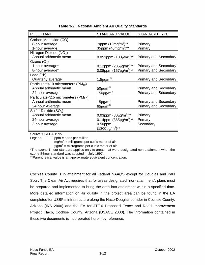
3.8 Air Quality
The State of Arizona has adopted the National Ambient Air Quality Standards (NAAQS)
(40 CFR Part 50) as the state’s air quality criteria (Table 3-2). Primary standards are
established to protect public health while secondary standards provide protection for the
public's welfare including wildlife, climate, recreation, transportation, and economic
values. States are required to adopt ambient air quality standards that are at least as
stringent as the Federal NAAQS; however, the state standards may be more stringent.
Based on measured ambient criteria pollutant data, areas are designated as having air
quality better than the standard (attainment) or worse than the standard (nonattainment).
Naco Fence EA October 2002 Final Report 3-12
Table 3-2: National Ambient Air Quality Standards
POLLUTANT STANDARD VALUE STANDARD TYPE
Carbon Monoxide (CO) 8-hour average 9ppm (10mg/m3)** Primary 1-hour average 35ppm (40mg/m3)** Primary Nitrogen Dioxide (NO2) Annual arithmetic mean 0.053ppm (100µ/m3)** Primary and Secondary Ozone (O3) 1-hour average* 0.12ppm (235µg/m3)** Primary and Secondary 8-hour average* 0.08ppm (157µg/m3)** Primary and Secondary Lead (Pb) Quarterly average 1.5µg/m3 Primary and Secondary Particulate<10 micrometers (PM10) Annual arithmetic mean 50µg/m3 Primary and Secondary 24-hour average 150µg/m3 Primary and Secondary Particulate<2.5 micrometers (PM2.5) Annual arithmetic mean 15µg/m3 Primary and Secondary 24-hour Average 65µg/m3 Primary and Secondary Sulfur Dioxide (SO2) Annual arithmetic mean 0.03ppm (80µg/m3)** Primary 24-hour average 0.14ppm (365µg/m3)** Primary 3-hour average 0.50ppm
(1300µg/m3)** Secondary
Source: USEPA 1995. Legend: ppm = parts per million mg/m3 = milligrams per cubic meter of air µg/m3 = micrograms per cubic meter of air *The ozone 1-hour standard applies only to areas that were designated non-attainment when the ozone 8-hour standard was adopted in July 1997. **Parenthetical value is an approximate equivalent concentration.
Cochise County is in attainment for all Federal NAAQS except for Douglas and Paul
Spur. The Clean Air Act requires that for areas designated “non-attainment”, plans must
be prepared and implemented to bring the area into attainment within a specified time.
More detailed information on air quality in the project area can be found in the EA
completed for USBP’s infrastructure along the Naco-Douglas corridor in Cochise County,
Arizona (INS 2000) and the EA for JTF-6 Proposed Fence and Road Improvement
Project, Naco, Cochise County, Arizona (USACE 2000). The information contained in
these two documents is incorporated herein by reference.
Naco Fence EA October 2002 Final Report 3-13
3.9 Water Resources
The project area receives water from surface runoff and groundwater via precipitation
and snowmelt in the local mountains. Geologic forces have created a regional terrain
that includes arroyos or washes (deep gullies), steep canyons, and somewhat flat
basins. Due to the arid climate of the area, most of the drainage channels are dry much
of the year. Rivers and streams that flow periodically due to fluctuations in precipitation
are referred to as being ephemeral. Intermittent waterways (rivers, streams, etc.) are
those that flow as a result of seasonal precipitation. Due to the flash flood tendency of
the washes, sediment loads are high when water is present. Natural and human-induced
factors determine the quality of these resources. Numerous small ephemeral drainages
transect the project area.
The major surface water drainage near the project area is the Greenbush Draw, which
flows just north of Naco and is a tributary of the San Pedro River. Numerous smaller
streams, which are intermittent or ephemeral in nature, flow to or from the draw
depending on topography.
Groundwater resources in the surrounding areas are available from both unconfined
(water table) and confined (artesian aquifer) conditions. Water depths to unconfined
water are between 50 and 570 feet, while confined water can be found from 500 to 1,000
feet below the ground (USACE 2000).
More information on surface and groundwater resources within the Naco area is
described in detail in the EA for Infrastructure within USBP Naco-Douglas Corridor,
Cochise County, Arizona (INS 2000) and the EA for JTF-6 Proposed Fence and Road
Improvement Project, Naco, Cochise County, Arizona (USACE 2000). The information
contained in these two EAs is incorporated herein by reference (USACE 2000; INS
2000).
3.9.1 Waters of the U.S. and Wetlands
There are no jurisdictional waters of the United States, including wetlands, within the
project site (USACE 2000).

Naco Fence EA October 2002 Final Report 3-14
3.10 Socioeconomics
The 2000 census estimated the population of Cochise County to be 117,755 with Naco’s
population accounting for approximately 833 of the total (U.S. Census Bureau 2001).
The four major towns closest to the project area are Huachuca, Bisbee, Douglas, and
Sierra Vista. More information, incorporated herein by reference, can be found in the EA
for Infrastructure within USBP Naco-Douglas Corridor, Cochise County, Arizona (INS
2000) and the EA for JTF-6 Proposed Fence and Road Improvement Project, Naco,
Cochise County, Arizona (USACE 2000).
3.11 Noise
The three common classifications of noise are: (1) general audible noise that is heard by
humans; (2) special noise, such as sonic booms and artillery blasts that can have a sound
pressure or shock component; and (3) noise-induced vibration also typically caused by
sonic booms and artillery blasts involving noise levels that can cause physical movement
(i.e., vibration) and even possible damage to natural and man-made structures such as
buildings and cultural resource structures. Most noise sources will fall within the audible
noise classification because of the rural nature of the majority of the project area.
Audible noise typically is measured in A-weighted sound pressure levels expressed in
decibels (dBA). The A-scale de-emphasizes the low and high frequency portions of the
sound spectrum and provides a good approximation of the response of the average
human ear. On the A-scale, zero dBA represents the average least perceptible sound,
such as gentle breathing, and 140 dBA represents the intensity at which the eardrum may
rupture, such as a jet engine at open throttle (National Research Council 1977).
Since the proposed activities are not capable of attaining the speed of sound and thus are
incapable of causing special noises, all noise levels discussed herein are measured on the
A-scale dBA. Normal rural noise levels in the project area would range from a low of 35
dBA over the majority of the corridor to a high 60 dBA near any rural community. More
detailed information on noise in the project area can be found in previous EAs (INS 2000;
USACE 2000) and is incorporated herein by reference.

SECTION 4.0ENVIRONMENTAL CONSEQUENCES

Naco Fence EA October 2002 Final Report 4-1
4.0 ENVIRONMENTAL CONSEQUENCES
This section of the EA addresses potential impacts to the affected environment within
the Naco area for the No Action and Preferred Alternatives outlined in Section 2.0.
4.1 Land Use
4.1.1 No Action Alternative
Implementation of the No Action Alternative would not affect current land use within the
Naco area.
4.1.2 Preferred Alternative
No changes to land use in this area would occur from implementing this alternative. The
project area is currently used as a border enforcement zone and would continue to be
used as such. Fencing would be installed along the existing border roadway.
4.2 Soils And Prime Farmland
4.2.1 No Action Alternative
Implementation of the No Action Alternative would eliminate potential direct disturbances
to soils from further construction activities. Regardless of the alternative selected,
existing erosion problems would continue, since the USBP would continue to use the
roads for patrol activities. Soils found in the Naco area have medium to high erosion
hazards, depending on the slope. Maintenance activities would occur along the existing
road adjacent to the border, but soil erosion would continue to be a problem.
Implementation of the No Action Alternative would have no effect on prime farmland in
the project area because there are no prime farmlands.
4.2.2 Preferred Alternative
Construction activities addressed under this alternative would occur in proximity to the
border road, where soils are already considered disturbed. The only ground disturbance
expected would be during the occasional installation of support poles. The holes would
Naco Fence EA October 2002 Final Report 4-2
be about eight inches in diameter and backfilled with concrete. Best management
practices (BMPs) would be incorporated into the construction plan to control erosion.
Prime and unique farmlands are not found within the Naco-Douglas Corridor (Wilson
2000; Bemis 2000).
4.3 Vegetation
4.3.1 No Action Alternative
Implementation of the No Action Alternative would eliminate the potential for direct
disturbances to vegetation from further construction activities. However, the existing
road right-of-way where all fence construction would occur is already devoid of
vegetation due to previous construction and maintenance activities.
Impacts to vegetation outside the maintained road corridor from illegal entrants would
continue to occur. Indirect effects have occurred to vegetation by illegal entrants
diverting around fences or away from areas that are heavily patrolled. Improvements in
the infrastructure and increases in patrol activities have resulted in some illegal entrants
redirecting their efforts into more remote areas. Increases in illegal foot and vehicle
traffic would continue to result in damage to vegetation.
4.3.2 Preferred Alternative
This alternative would include the conversion of 1.2 miles of vehicle barrier to landing
mat fence. The corridor along which the action would take place has been previously
disturbed and no additional impacts to vegetation are expected. The conversion to
landing mat fence should substantially reduce secondary impacts to vegetation from
illegal entry within the project area.
However, indirect effects could occur to the vegetation beyond the project area by UDAs
attempting to avoid the fenced corridor. The magnitude of these effects cannot be
determined at the present, since the routes selected by UDAs and smugglers are at their
discretion and out of the control of the USBP.
Naco Fence EA October 2002 Final Report 4-3
4.4 Wildlife
4.4.1 No Action Alternative
The No Action Alternative would not allow the conversion of the vehicle barrier to a
fence. Larger mammals and herpetiles would benefit from the No Action Alternative
since solid fences can impede movement by such species. Fences have also afforded
protection to some wildlife species and other sensitive resources by reducing habitat
disturbances caused by UDA activities. Fences do significantly reduce illegal entries
and, indirectly, reduce the amount of foot traffic within wildlife communities in the U.S.
4.4.2 Preferred Alternative
No additional direct impacts to wildlife resources are expected from the conversion of the
vehicle barrier to landing mat fence since no additional wildlife habitat would be altered.
However, the landing mat fence would create a barrier to wildlife movement, especially
for larger mammals and herpetiles. The magnitude of this impact cannot be quantified at
the present. However, there are no wildlife populations in the project area that are
sensitive to potentially slight reductions in genetic variability. Therefore, impeding some
local wildlife movement in this area is not considered significant.
4.5 Unique or Sensitive Areas
There are no areas classified as unique or sensitive natural areas found within the
proposed project area.
4.6 Protected Species and Critical Habitats
4.6.1 No Action Alternative
The No Action Alternative would have no effect on protected species or designated
critical habitats. However, increased and continued illegal traffic and the consequent
enforcement activities could be adverse to protected species and critical habitats.
4.6.2 Preferred Alternative
No listed threatened or endangered species or their designated critical habitats are known
to occur within the project area. Thus, the proposed activities within the project area

Naco Fence EA October 2002 Final Report 4-4
would not be expected to adversely affect protected species or critical habitats. No
Federally listed species were found in the project area during the surveys conducted in
March and April 2002.
No agaves or columnar cacti, a preferred food source for the lesser long-nosed bat,
were located in the project site during surveys performed in March and April 2002.
Agaves are present in the surrounding communities, but would not be disturbed by the
proposed action.
There have been no confirmed sightings of the ocelot, jaguar, and jaguarundi in the
project area. The conversion of 1.2 miles of vehicle barriers to landing mat fence is not
expected to have a negative effect on the migration patterns of these three species,
since they are not known to occur in the project area. The proposed fence is located
approximately one mile from the Naco POE; this area receives heavy traffic and is
urbanized. The presence of these feline species in this type of environment would be
unlikely. The closest feline sighting to the project area was one ocelot reported in the last
two years on the Mexico side of the border near Douglas, Arizona, approximately 20
miles east of the project area.
4.7 Cultural Resources
4.7.1 No Action Alternative
The No Action Alternative would not result in any direct effects to cultural resources.
However, as illegal traffic, and the consequent enforcement actions continue, indirect
effects to known and undiscovered sites would continue to occur.
4.7.2 Preferred Alternative
Conversion to landing mat fence would not directly affect any cultural resource sites,
since no additional ground disturbance would be required. Indirect beneficial effects
would occur, however, by reducing illegal foot traffic in the area.

Naco Fence EA October 2002 Final Report 4-5
4.8 Air Quality
4.8.1 No Action Alternative
The No Action Alternative would eliminate all potential emission sources associated with
the proposed vehicle barrier conversion. No further impacts, beneficial or adverse, are
expected to occur under the No Action Alternative.
4.8.2 Preferred Alternative
Air quality impacts from construction and maintenance activities of fences include
emissions due to fuel combustion from heavy equipment, and fugitive dust due to travel
through the construction area. Particulate concentrations would be expected to be below
de minimis thresholds due to the short duration of the construction activities and
negligible ground disturbances. Thus, the proposed action would not violate national
standards. All impacts would be temporary in nature.
4.9 Water Resources
4.9.1 No Action Alternative
No impacts to water resources would be expected under this alternative.
4.9.2 Preferred Alternative
Conversion to landing mat fence would not affect any water resources since none occur
within the project corridor (USACE 2000).
4.10 Socioeconomics
4.10.1 No-Action Alternative
The No Action Alternative would provide no direct effects to socioeconomic resources.
Indirect effects due to the lack of deterrence to illegal aliens and smugglers and the
reduced capability of the USBP agents to apprehend illegal entrants would include
increased crime, loss of property, and costs of social programs.

Naco Fence EA October 2002 Final Report 4-6
4.10.2 Preferred Alternative
Materials and other project expenditures would predominantly be obtained through
merchants in the local community, providing minor increases to the local economy.
Landing mat panels, as discussed previously, are wartime surplus items and thus would
not be purchased. Labor would be obtained through the National Guard, active/reserve
military units primarily through JTF-6, USBP maintenance staff, or commercial
contractors.
4.10.3 Environmental Justice
Executive Order 12898 of February 11, 1994, “Federal Actions to Address
Environmental Justice in Minority Populations and Low-Income Populations” require
each Federal agency to identify and address, as appropriate, disproportionate adverse
effects of its proposed actions on minority populations and low-income communities.
The racial mix of Cochise County is about 90 percent Caucasians, and less than half (34
percent) of the entire county population claim to be of Hispanic origin. The proposed
projects would not displace residences or commercial structures in or around the project
area. Therefore, disproportionate effects to minority populations would not be expected.
Cochise County has about 21 percent of its total population living at or below poverty
levels. The 1997 per capita personal income was estimated to be about $17,000, which
indicated a 28 percent increase since 1990. However, the proposed action’s location is
east of Naco and remote to any low-income neighborhoods. Consequently, no
disproportionate adverse effects to low-income populations would be expected from the
implementation of any of the alternatives.
On the other hand, implementation of the Preferred Alternative would enhance the
probability of success for the INS/USBP. This increased success in controlling illegal
drug activity and the increasing flow of UDAs into the Naco area would benefit all
populations, regardless of income, nationality, or ethnicity. In addition, construction
activities would have short term, but positive impacts on local economies from sales of
construction materials, other project expenditures, and temporary employment. Long
term positive impacts would occur on local, regional, and national levels by the reduction
of illegal immigrants and drug trafficking and the associated social costs.
Naco Fence EA October 2002 Final Report 4-7
In addition, the Proposed Action alternative is not expected to generate
disproportionately high environmental health and safety risks to children as specified by
Executive Order 13045, “Protection of Children from Environmental Health Risks.” This
Executive Order was prompted by the recognition that children, still undergoing
physiological growth and development, are more sensitive to adverse environmental
health and safety risks than adults.
4.11 Noise Effects
4.11.1 No Action Alternative
Implementation of the No Action Alternative would result in no additional INS or USBP-
related construction activities, and, thus, no increases in ambient noise levels.
4.11.2 Preferred Alternative
If this alternative was selected, equipment, such as welding machines, cranes, and
trucks, would cause temporary increases in noise levels. The magnitude of these effects
would depend upon the time of year, proximity to sensitive receptors (e.g. schools,
hospitals, churches, and residences), climatic conditions, type and number equipment
pieces, and terrain. Based on past similar activities, the construction would occur only
during daylight, thus reducing the day-night average sound level and the chances of
causing annoyances. No blasting would be expected.
Animals, particularly domesticated species, would be expected to quickly habituate to
construction noise. Wildlife may at first be startled and flee the construction area;
however, wildlife species, too, have demonstrated rapid habituation, even to loud and
sudden noises which cause panic responses. Bowles (1997) reported that habituation
could occur with fewer than five exposures. Several other recent studies (Workman et al.
1992; Krausman et al. 1993, 1998; Weisenberger et al. 1996) have indicated that wildlife
habituate through repeated exposure without long-term discernible negative effects.
Ambient noise levels would return upon completion of the proposed projects with no
long-term, significant adverse impacts. The project area is rural and is not in the vicinity
of sensitive receptors. No significant adverse effects would be expected.
Naco Fence EA October 2002 Final Report 4-8
4.12 Cumulative Effects
This section of the EA addresses the cumulative impacts associated with the proposed
conversion activities and other projects/programs that are planned for the region.
4.12.1 No Action Alternative
Approximately 126 acres of wildlife habitat near Naco have been impacted by fence
construction, new road construction, road improvements, and the installation of stadium
lighting and RVS sites in the past five years. Of these 126 acres, 62 acres are located in
Chihuahuan desert scrub, 48 acres are located in semi-desert grassland, 11 acres are
located in Madrean Evergreen Woodland, and five acres are located in plains grassland.
However, there is no documented evidence that wildlife populations in the area were
significantly impacted by this habitat loss. The linear nature of the clearing for road
construction, upgrade, and fence and stadium lighting right-of-ways, and, more
importantly, the highly degraded and disturbed nature of the majority of the project
locations have contributed to the determination of negligible effects to wildlife
populations. In general, these impacts did not result in a significant reduction in the
number of animals whose home range is within or adjacent to the project area, and no
change in the overall species composition of the area is believed to have occurred due
to these projects.
Wildlife movement in the project area might have been impacted by the infrastructure
construction and maintenance over the past five years; however, there is no
documentation of this effect. The greatest effect to movement of small animals generally
happens when a disturbance such as road grading, dozing, or fence construction occurs.
Mobile animals escaped to areas of similar habitat, while other slow or sedentary
animals such as reptiles, amphibians, and small mammals were potentially lost. This
displacement and/or reduction in the number of animals did not significantly impact
animal communities due to the presence of similar habitat adjacent to the project area.
Larger terrestrial wildlife movements in the construction and maintenance areas were
not affected due to the short duration of construction activities at each site. Additionally,
construction activities were only conducted during daylight hours. No construction

Naco Fence EA October 2002 Final Report 4-9
activities were conducted during the early morning hours or nighttime hours when wildlife
species are most active.
Roads and fences resulted in other indirect impacts. Improved roads increased the
speed at which vehicles travel and increased traffic as well. Higher vehicular speeds
decreased the response time for wildlife to avoid the vehicles, and thus, potentially
increased the number of accidental wildlife deaths. Fences serve as a barrier to wildlife
species; the magnitude of this effect depends upon the fence design and location.
Fences that would act as a physical barrier to wildlife are generally constructed at or
near POEs, which are located within very developed areas. Consequently, such fences
do not have a significant effect on wildlife movement. Vehicle barriers do not impede
wildlife movement or remove/alter significant amounts of wildlife habitat.
The No Action Alternative would result in no additional direct effects to the area's
resources. No threatened or endangered species or critical habitat would be affected,
nor would there be any adverse effects on cultural resources sites or historic structures
that are listed or potentially eligible for listing on the NRHP. Likewise, no additional direct
impacts to air quality, water resources, soils, and socioeconomic conditions would occur
under this alternative.
Long term indirect cumulative effects have occurred and would continue to occur to the
area’s natural habitats from a variety of sources such as urban development, mining
operations, off-road recreational vehicles, ranching, UDA traffic, and USBP and INS
activities; however, these effects, both beneficial and adverse, are difficult, if not
impossible, to quantify. Reductions in habitat have undoubtedly created inter- and intra-
species competition for available food and shelter and, eventually, slight reductions in
some wildlife populations. Given the rural nature of Cochise County, 126 acres of altered
habitat would be a negligible loss.
The increase in lights along the border also could have produced some long-term
cumulative effects, although the magnitude of these effects in some areas is not
presently known. Some species, such as insectivorous bats, may benefit from the
concentration of insects that would be attracted to the lights. Circadian rhythms of other
diurnal species, however, may be disturbed enough that breeding or feeding patterns
Naco Fence EA October 2002 Final Report 4-10
are skewed, causing synergistic physiological changes. Increased patrol activities would
increase the potential for some wildlife specimens to be accidentally hit and killed. Such
losses would not be expected to result in significant reductions to the populations.
The USBP Naco Station currently maintains about 21 miles of drag roads throughout its
2,000 square mile AO. Drag roads are existing, unimproved roads that are highly
traveled or regularly crossed by UDAs or smugglers. The surface of these roads is
prepared using a method known as dragging. Dragging is accomplished by the use of a
4-wheel drive vehicle towing several tires bolted together and pulled on sections of the
road at speeds between five and seven miles per hour. This method erases old tracks
and smoothes the road surface so any new tracks crossing the road can be easily
located. These roads are located within known UDA and smuggler travel corridors and
are instrumental in detecting evidence of vehicle and/or pedestrian crossings. Many of
these roads are open to the public and used as general transportation routes. The Naco
Station will drag these roads at least daily and occasionally up to three times per day.
Since dragging occurs on existing roads, no direct effects to vegetation or wildlife
occurs. However, the dragging activities do produce fugitive dust, which settles on
adjacent vegetation and can result in reduced photosynthesis.
Helicopter flights are conducted within the Naco Stations AO on a daily basis, with no set
flight pattern. However, the reconnaissance flights are typically flown along the
international border of State Highway 92, at altitudes of about 200 to 300 feet above
ground level. The purpose of these flights is multifold: (1) identify signs of illegal entry,
(2) assist in the apprehension of UDAs and smugglers, (3) serve as a deterrent to illegal
entry, (4) serve as force multiplier, (5) enhance the efficiency and effectiveness of
ground patrols and, (6) provide search and rescue missions for UDAs and smugglers.
While these flights can cause temporary disturbances to wildlife and recreationists, they
are considered to be negligible due to the short duration and infrequency of the
disturbance.
Positive cumulative benefits have resulted from INS activities as well. Additional
knowledge regarding threatened or endangered species’ locations, distribution, and life
requisites has been obtained through surveys and monitoring efforts associated with INS

Naco Fence EA October 2002 Final Report 4-11
construction projects. Erosion has been alleviated along some roads, and fences have
precluded illegal foot and vehicular traffic through environmentally sensitive areas.
The INS/USBP is currently in the early stages of planning road improvements along a 4-
mile reach east and west of the Naco POE. These improvements would include grading
and resurfacing the existing roadway and installing up to four low water crossings to
provide an all-weather patrol road. The INS/USBP is also in the preliminary planning
phase of identifying/designing infrastructure projects along the entire international border
within the Naco and Douglas Stations AO. This infrastructure could include primary and
secondary fences, lights, RVS, and patrol/drag roads within a 300-foot corridor. These
activities are being planned and would require additional NEPA documentation to
analyze and present the impacts and mitigation, if required.
Plans by other agencies in the region which would also affect the region’s natural and
human environment include the road improvements by Arizona Department of
Transportation (ADOT), the commercial truck U.S. Highway 80 bypass and border
crossings near Douglas, the Bisbee-Douglas International Airport expansion, and the
reactivation of the abandoned Southern Pacific rail line by SWKR, Inc to the west of
Naco. With the exception of the proposed new bypass and border crossing near
Douglas, the remaining projects would be along existing corridors and/or within
previously disturbed sites (e.g., airport). Land use would change along the bypass, and
additional wildlife habitat would be lost. The magnitude of these effects would depend
upon the length and width of the bypass right-of-way (ROW) and the extant conditions
within and adjacent to the ROW.
Reactivation of the rail line and crossing near Naco would result in additional habitat
losses, even though the rail would probably be constructed along the existing, but
abandoned, line. The tracks were removed in 1975 and the line has begun to
revegetate. Reactivation of the line would also increase noise in the immediate vicinity
and increase potential health and safety risks due to transportation of hazardous cargo.
4.12.2 Preferred Alternative
Implementation of this alternative would have similar cumulative effects as the No Action
Alternative, since very little, if any, ground disturbances would occur. Furthermore, any

Naco Fence EA October 2002 Final Report 4-12
of the disturbances would occur within areas that are already heavily disturbed by on-
going or past activities. The primary cumulative effect that would occur under the
Preferred Alternative, as opposed to the No Action Alternative, would be the barrier to
wildlife movement, especially for larger mammals and herpetiles; no provisions have
been made for small mammal passageways through the fence. The magnitude of this
impact cannot be quantified at the present, but there are no wildlife populations in the
project area that are anticipated to be sensitive to potentially slight reductions in genetic
variability. Also, the fence would be constructed in an area that has already been
developed and wildlife species would most likely not be utilizing the project area for habitat
or for migration purposes. Therefore, the potential to impede wildlife movement in this area
is not considered significant.
Construction activities would result in temporary emissions, but they are short term and
would not be expected to add significantly to the cumulative effects.
Indirect effects could occur to the vegetation beyond the project area by UDAs
attempting to avoid the fenced corridor. USBP would patrol areas beyond the landing
mat fence to apprehend UDAs, which would lessen any indirect effects to vegetation
from illegal traffic trying to skirt around the barrier. The magnitude of these effects
cannot be determined at the present, since the routes selected by UDAs and smugglers
are at their discretion and out of the control of the USBP. Since there are no plans for
ground disturbing activities, no provisions have been made to prevent UDAs or
smugglers from tunneling under the fence.
Future plans to construct bollard style fencing between where the existing landing mat
fence ends and where the proposed landing mat fence would begin have been designed
(see Figure 1-1). This is a section along the border where a minor drainage crosses into
Mexico, and the bollard style fence would allow for seasonal water events to flow
unimpeded. Also, bollard fence, as described in Section 2.3.2, leaves small gaps in
between the poles, allowing for small mammals and herpetiles to cross though. This
section of bollard style fence is approximately 0.2 mile and would be addressed under a
separate NEPA document.

SECTION 5.0ENVIRONMENTAL DESIGN MEASURES

Naco Fence EA October 2002 Final Report 5-1
5.0 ENVIRONMENTAL DESIGN MEASURES
This chapter describes those measures that could be implemented to reduce or
eliminate potential adverse impacts to the human and natural environment. Many of
these measures have been incorporated as standard operating procedures by INS and
USBP on past projects. Environmental design measures are presented for the resource
category that could be potentially affected. The proposed mitigation measures would be
coordinated through the appropriate agencies and land managers/administrators.
5.1 Air Quality
Proper and routine maintenance of all vehicles, generators, and other equipment would
be implemented to ensure that air emissions are within the design standards of the
equipment. If bivouac sites were required (in the event the National Guard or other
military units are used for construction services), generators and other similar field
equipment would be kept to the minimum required. Where practicable, drop lines from
local electrical systems would be used as a substitute for generators.
Project-related emissions would be minimized by the implementation of BMPs in the
form of a truck watering program for roads and construction zones within the project
area, construction curtailed in winds exceeding 25 miles per hour, efficient utilization of
equipment to minimize the amount of time engines are left idling, and upkeep and
maintenance of construction equipment to ensure that engines and emission systems
are properly tuned. Any necessary air quality operating permits are the responsibility of
the contractor.

SECTION 6.0PUBLIC INVOLVEMENT

Naco Fence EA October 2002 Final Report 6-1
6.0 PUBLIC INVOLVEMENT
6.1 Agency Coordination
This chapter discusses consultation and coordination that would occur during
preparation of the draft and final versions of this document. This would include contacts
that are made during the development of the proposed action and writing of the EA.
Formal and informal coordination will be conducted with the following agencies:
• U.S. Fish and Wildlife Service (USFWS)
• U.S. Environmental Protection Agency (USEPA)
• Natural Resource Conservation Service (NRCS)
• Bureau of Land Management (BLM)
• Arizona State Historic Preservation Office (SHPO)
• Arizona Department of Transportation (ADOT)
• Arizona Game and Fish Department (AGFD)
• Arizona Department of Environmental Quality (ADEQ)
• Arizona Department of Agriculture
6.2 Public Review
The draft EA was made available for public review for a period of 30 days, and the Notice
of Availability (NOA) was published in the local newspaper. Proof of publication is included
in Appendix A of this document. A request was received from the public to extend the
comment period an additional 24 days and the request was granted. Three public
comment letters were submitted on the draft document and are included in Appendix A.
Summaries of the comments received and the responses to these comments are
presented in the following section.
The final EA will be released to the public and a NOA will be published in the local
newspaper. Exhibit 6-1 is a copy of the NOA that will be published for the final EA.

Naco Fence EA October 2002 Final Report 6-2
Exhibit 6-1
NOTICE OF AVAILABILITY
FINAL ENVIRONMENTAL ASSESSMENT
for Conversion of Vehicle Barriers to Landing Mat Fence
Naco, Cochise County, Arizona
The public is hereby notified of the availability of the final Environmental Assessment (EA) for fence construction along the U.S.-Mexico Border near Naco, Cochise County, Arizona. This EA addresses the conversion of 1.2 miles of existing vehicle barriers to landing mat fence along the International Border by welding landing mat panels to the vehicle barriers. The final EA will be available for review at the Douglas Library, 560 E. 10th Street, Douglas, Arizona 85607 or can be viewed and/or downloaded the U.S. Army Corps of Engineers, Fort Worth District’s webpage at http://www.swf.usace.army.mil/ins/Pages/Publicreview.cfm.

Naco Fence EA October 2002 Final Report 6-3
6.3 Comments and Responses
The following sections address the three comment letters received during the public
review of the draft EA.
6.3.1 SouthWest Alliance to Resist Militarization (SWARM)
Comment 1: The commenter claims that the EA is inadequate because of supposedly
erroneous statements regarding the lack of vegetation and wildlife at the project site.
Response 1: Since the proposed project is to weld landing mat fence to existing vehicle
barriers along the road, there would be no need to disturb any additional vegetation. The
road right-of-way is already devoid of vegetation due to vehicle traffic along the roadway,
and previous construction and maintenance activities, which were addressed under
previous NEPA documents (USACE 2000).
Nowhere in the document does it state, “no wildlife species were observed, so thus there
will be no impact on wildlife.” This EA addresses the potential impact to wildlife migration
patterns by converting vehicle barriers to landing mat fence. Section 3 discusses wildlife
species known to occur in the project area; none of these species were observed at the
project site during the survey conducted specifically for this project. No threatened or
endangered species are known to exist in the area. The project area is approximately one
mile from the POE and the border road along which the fence would be constructed
receives heavy vehicle traffic.
As stated in several places in the EA, no Federally listed flora or fauna threatened or
endangered species were located in the project area during the surveys conducted in
March and April 2002 or during previous surveys conducted in the region (INS 2001;
USACE 1993, 1994, 1996, 2000).
Comment 2: The commenter felt the EA did not adequately address the potential to the
ocelot, jaguar, and jaguarundi.
Response 2: Section 4.6 has been updated to specifically include the ocelot, jaguar, and
jaguarundi. Section 3.6 discusses all three species and the date and location of their last

Naco Fence EA October 2002 Final Report 6-4
sightings. These species are not expected to inhabit the project area, or use this area as a
migration corridor due to the proximity to the Naco POE and residential areas.
Comment 3: The commenter expressed a concern that there were potential cumulative
impacts to vegetation and wildlife or uncertainties about effects to the species that were
not sufficiently addressed or supported documentation.
Response 3: The cumulative effects section of the document thoroughly addresses past
and present effects in the area, such as road construction, lighting, fence, and actions by
other agencies. One paragraph in Section 4.12.1 discusses some long-term, indirect
cumulative effects as being unquantifiable. These effects have been defined further as
effects by UDAs, mining, ranching, recreation, urban development, and USBP and INS
activities, and are not only related to INS/USBP projects. Activities of this nature
continuously occur in the areas along the border, especially near POEs. Cumulative
effects expected from the implementation of the Proposed Action alternative have been
addressed in Section 4.12.2 and are concluded to not result in “significant” adverse effects
on vegetation or wildlife, as defined by 40 CFR Section 1508.27.
Comment 4: The commenter would like to see USBP “off-roading, helicopter flights, and
tire-dragging” included in the cumulative effects section, as well as all other USBP and
JTF-6 activities.
Response 4: The use of vehicles off designated roads (by the USBP and civilians),
helicopter flights, and tire-dragging have been added to the cumulative effects section of
the document. USBP and JTF-6 activities in and near the project area are addressed in
the cumulative effects section.
Comment 5: The commenter claims that the EA does adequately address the effects the
fence would allegedly have on human health and safety, particularly since the fence would
force migrants “into desolate and dangerous areas where there is no water or shelter from
the elements.”
Response 5: Migrants attempting to illegally cross the U.S-Mexico border are violating
Federal law. It is not the USBP or INS’s responsibility to “mitigate” for individuals who are

Naco Fence EA October 2002 Final Report 6-5
committing a crime. While it is true that immigrants have been known to attempt to illegally
cross the border in desolate areas, this is their choice. The USBP does not force illegal
immigrants into remote areas.
Comment 6: The commenter requested that Executive Order 13045, “Protection of
Children from Environmental Health Risks,” be addressed.
Response 6: EO 13045 has been addressed in Section 4.10.3 Environmental Justice of
this document. As for the health and safety of illegal immigrants trying to cross the border
in remote areas, please refer to the response to the above Comment 5.
6.3.2 Ernest M. Rogers
Comment 1: The commenter stated that USBP and INS “should make every effort to
ensure that the community’s input is included in construction projects.”
Response 1: This comment has been noted. The EA was made available to the public for
a period of 30 days, with an additional 24-day extension. A NOA was published in the local
newspaper (see Appendix A).
Comment 2: The commenter expressed concern that materials for the proposed project
had already been purchased and placed at the proposed site before the public comment
period had closed.
Response 2: The USBP and INS have other on-going projects in the Naco area. The
materials that the commenter referred to had been purchased and will be used for these
projects. Materials for the proposed project have not been purchased.
Comment 3: The commenter stated that they are in favor of the proposed project.
Response 3: This comment has been noted.

Naco Fence EA October 2002 Final Report 6-6
6.3.3 Alejandro Jimenez S.
Comment 1: The commenter stated that USBP and INS “should make every effort to
ensure that the community’s input is included in construction projects.”
Response 1: This comment has been noted. The EA was made available to the public for
a period of 30 days, with an additional 24-day extension. A NOA was published in the local
newspaper (see Appendix A).
Comment 2: The commenter expressed concern that materials for the proposed project
had already been purchased and placed at the proposed site before the public comment
period had closed.
Response 2: The USBP and INS have other on-going projects in the Naco area. The
materials that the commenter referred to had been purchased and will be used for these
projects. Materials for the proposed project have not been purchased.
Comment 3: The commenter stated that they are in favor of the proposed project.
Response 3: This comment has been noted.
6.3.4. U.S. Fish and Wildlife Service
On September 13, 2002, Mr. Chris Ingram of Gulf South Research Corporation spoke with
Ms. Thetas Gamberg from the USFWS via telephone.
Comment 1: Ms. Gamberg stated that two listed species’ statuses have changed. The
Chiricahua leopard frog is now listed as threatened and the Gila chub has been changed
from a candidate species to proposed endangered.
Response 1: The new designations have been updated in Table 3-1.

SECTION 7.0REFERENCES

Naco Fence EA October 2002 Final Report 7-1
7.0 REFERENCES
Arizona Department of Commerce. 2000. Internet website: http://www.commerce.state.az.us/
Arizona Fish and Game Department (AGFD). 2000. List of Special Status Species for
Cochise County, Arizona. Maintained by the AGFD-Heritage Data Management System. Compiled 19 June 2000.
AGFD. 2001. Last confirmed sightings of the ocelot, jaguar, and jagarundi in southwest
Arizona. Personal communications between Ms. Lori Averill-Murray, AGFD, and Ms. Kate Koske, GSRC, 1 October 2001.
Arizona Mining Association. 2000. Internet website: http://www.azcu.org/ Bat Conservation International. Bat Species: U.S. Bats: Leptonycteris curasoae.
http://www.batcon.org. Accessed 2 October 2001. Bemis, R. Personal Communication. Soil Scientists for the United States Department of
Agriculture, Natural Resources Conservation Service. June 23, 2000. www.epa.gov/surf3/hucs/15050202/
Bowles, A.E. 1997. Effects of Recreational Noise on Wildlife: An Update. Hubbs-Sea
World Research Institute, San Diego, CA. Brown, D.E. (ed.). 1994. Biotic Communities of the American Southwest-United States
and Mexico. University of Arizona. Brown, D.E. and C.H. Lowe. 1983. Biotic Communities of the Southwest. U.S.
Department of Agriculture Forest Service General Technical Report RM-78. Rocky Mountain Forest and Range Experiment Station, Fort Collins, Colorado.
Dice, L.R. 1943. The Biotic Provinces of North America. University of Michigan Press, Ann Arbor, Michigan. 78 p.
Dye, Lee. 2002. Where the Jaguars Roam…Wild Jaguars Become a Frequent Sight in
Arizona. ABCNEWS.com, 21 February 2002. Accessed 21 February 2002. Hendricks, D.M. 1985. Arizona Soils. College of Agriculture, University of Arizona Press.
Tucson, Arizona. 244 p. Immigration and Naturalization Service (INS). 2000. Final Environmental Assessment
For Infrastructure Within U.S. Border Patrol Naco-Douglas Corridor, Cochise County, Arizona. U.S. Immigration and Naturalization Service, Washington, D.C.
INS. 2001. Final Environmental Assessment for Portable Lights within the Naco Corridor,
Cochise County, Arizona. U.S. Immigration and Naturalization Service, Washington D.C.
Naco Fence EA October 2002 Final Report 7-2
INS. 2002. Final Environmental Assessment for Road Improvements along King’s Ranch Road and the U.S.-Mexico Border near Douglas, Cochise County, Arizona. U.S. Immigration and Naturalization Service, Washington D.C.
Krausman, P.R., M.C. Wallace, D.W. DeYoung, M.E. Weisenberger, and C.L. Hayes.
1993. The Effects of Low-altitude Jet Aircraft on Desert Ungulates. International Congress: Noise as a Public Health Problem 6:471-478.
Krausman, P.R., M.C. Wallace, D.W. DeYoung, M.E. Weisenberger, and C.L. Hayes.
1998. Effects of Jet Aircraft on Mountain Sheep. Journal of Wildlife Management 62:1246-1254.
National Research Council. 1977. Guidelines for Preparing Environmental Impact
Statements on Noise. Prepared by the Committee on Hearing, Bioacoustics, and Biomechanics, Assembly of Behavior and Social Sciences. Office of Naval Research, Contract No. N00014. Washington D.C.
Tewes, Dr. Michael. 2001. Last confirmed sightings of the ocelot, jaguar, and jagarundi
in southwest Arizona. Personal communications between Dr. Tewes, Texas A&M-Kingsville, and Ms. Kate Koske, GSRC, October 1, 2001.
University of Arizona. Lesser Long-nosed Bat.
http://ag.arizoan.edu/~shelleyd/LN%20Bats.html. Accessed 29 October 2001. U.S. Army Corps of Engineers (USACE). 1993. Final Environmental Assessment for the
JTF-6, Border Road Maintenance and Repair, Naco, Cochise County, Arizona. USACE, Los Angeles District, Los Angeles, California.
USACE. 1994. Final Environmental Assessment for the JTF-6, Border Fence and Road
Repair, Naco, Cochise County, Arizona (JT044-94). USACE, Los Angeles District, Los Angeles, California.
USACE. 1996. Final Environmental Assessment for the JTF-6 Road Maintenance and
Construction Naco-Douglas, Cochise County, Arizona (JT315-96). U.S. Army Corps of Engineers, Fort Worth District, Fort Worth, Texas.
USACE. 2000. Final Environmental Assessment Joint Task Force Six Proposed Fence
and Road Improvement Project, Naco, Cochise County, Arizona. U.S. Army Corps of Engineers, Fort Worth District, Fort Worth, Texas.
USACE. 2001. Relocation and Assessment of Thirty-One Sites along the U.S.-Mexico
International Border between Douglas and Naco, Cochise County, Arizona. U.S. Census Bureau. 2001. 2001 Census of Population. American FactFinder.
http://factfinder.census.gov/servlet/BasicFactsServlet. Accessed 2 January 2002 and 28 March 2002.
U.S. Environmental Protection Agency (USEPA). 1995. AP-42: Compilation of Air
Pollutant Emission Factors. Volume I: Stationary Point and Area Sources. 5th Edition.

Naco Fence EA October 2002 Final Report 7-3
U.S. Fish and Wildlife Service (USFWS). 2000. Southwest Region Ecological Services. Endangered Species List for Cochise County, Arizona. 26 June 2000. http://ifw2es.fws.gov/EndangeredSpecies/lists/ListSpecies.cfm.
USFWS. 2001. Listed, Proposed, and Candidate Species List for Cochise County,
Arizona. 11 October 2001. Weisenberger, M.E., P.R. Krausman, M.C. Wallace, D.W. DeYoung, and E.E. Maughan.
1996. Effects of Simulated Jet Aircraft Noise on Heart Rate and Behavior of Desert Ungulates. Journal of Wildlife Management 60:52-61.
Wilson, R. Personal Communication. Soil Scientists for the U.S. Department of
Agriculture, Natural Resources Conservation Service. 23 June 2000. www.epa.gov/surf3/hucs/15050202/.
Workman, G.W., T.D. Bunch, J.W. Call, R.C. Evans, L.S. Neilson, and E.M. Rawlings.
1992. Sonic Boom/Animal Disturbance Studies on Pronghorn Antelope, Rocky Mountain Elk, and Bighorn Sheep. Utah State University Foundation, Logan. Prepared for U.S. Air Force, Hill AFB, Contract F42650-87-C-0349.

SECTION 8.0LIST OF ACRONYMS/ABBREVIATIONS

Naco Fence EA October 2002 Final Report 8-1
8.0 ACRYONYMS ADEQ Arizona Department of Environmental Quality ADOT Arizona Department of Transportation AGFD Arizona Game and Fish Department AO Area of operation BLM Bureau of Land Management BMP Best Management Practice CEQ Council on Environmental Quality CFR Code of Federal Regulations CO Carbon monoxide dBA decibel EA Environmental Assessment ESA Endangered Species Act IBWC International Boundary and Water Commission IIRIRA Illegal Immigration Reform and Immigrant Responsibility Act INA Immigration and Nationality Act INS Immigration and Naturalization Service JTF-6 Joint Task Force Six µg/m3 Micrograms per cubic meter mg/m3 Milligrams per cubic meter msl mean sea level NAAQS National Ambient Air Quality Standards NEPA National Environmental Policy Act of 1969 NRHP National Register of Historic Places NRCS Natural Resource Conservation Service NOA Notice of Availability NO2 Nitrogen Dioxide O3 Ozone PM10 Particulate matter measuring less than 10 micrometers PM2.5 Particulate matter measuring less than 2.5 micrometers Pb Lead POE Port of Entry ppm Parts per million ROW Right-of-way RVS Remote Video Surveillance SHPO State Historic Preservation Office SO2 Sulfur dioxide UDA Undocumented Alien USACE U.S. Army Corps of Engineers USBP U.S. Border Patrol USC U.S. Code USEPA U.S. Environmental Protection Agency USFS U.S. Forest Service USFWS U.S. Fish and Wildlife Service

SECTION 9.0LIST OF PREPARERS

9.0
LIS
T O
F P
RE
PA
RE
RS
T
he fo
llow
ing
peop
le w
ere
prim
arily
res
pons
ible
for
prep
arin
g th
is E
nviro
nmen
tal A
sses
smen
t. NA
ME
A
GE
NC
Y/O
RG
AN
IZA
TIO
N
D
ISC
IPL
INE
/EX
PE
RT
ISE
E
XP
ER
IEN
CE
R
OL
E IN
PR
EP
AR
ING
EA
Eric
Ver
wer
s
INS
A-E
Res
ourc
e C
ente
r B
iolo
gy
14 y
ears
in N
EP
A a
nd r
elat
ed
stud
ies
Pro
gram
man
ager
and
EA
re
view
and
coo
rdin
atio
n
Cha
rles
Par
sons
IN
S W
este
rn R
egio
n,
Env
ironm
enta
l Offi
cer
Geo
logy
23
yea
rs in
geo
tech
nica
l and
en
viro
nmen
tal s
tudi
es
EA
rev
iew
and
coo
rdin
atio
n
Gilb
ert E
stra
da
U.S
. Bor
der
Pat
rol-T
ucso
n S
ecto
r U
.S. B
orde
r P
atro
l 22
yea
rs e
xper
ienc
e of
US
BP
op
erat
ions
E
A r
evie
w a
nd c
oord
inat
ion
Pat
ienc
e P
atte
rson
U
.S. A
rmy
Cor
ps o
f Eng
inee
rs,
For
t Wor
th D
istr
ict
Arc
haeo
logy
29
yea
rs P
rofe
ssio
nal
Arc
haeo
logi
st/C
ultu
ral
Res
ourc
e M
anag
er
EA
rev
iew
and
coo
rdin
atio
n
Am
elia
Edw
ards
H
DR
Eng
inee
ring,
Inc.
P
rogr
am M
anag
er /
Tra
nspo
rtat
ion
Eng
inee
r 11
yea
rs E
ngin
eerin
g an
d P
rogr
am M
anag
emen
t E
A r
evie
w a
nd c
oord
inat
ion
Jim
Mal
usa
Priv
ate
Con
trac
tor
Bot
any
10+
year
s bo
tani
cal s
urve
ys
Fie
ld s
urve
y
Chr
is In
gram
G
ulf S
outh
Res
earc
h C
orpo
ratio
n B
iolo
gy/E
colo
gy
22 y
ears
EA
/EIS
stu
dies
Im
pact
ana
lysi
s an
d E
A
revi
ew; F
ield
sur
vey
Sun
a A
dam
K
naus
G
ulf S
outh
Res
earc
h C
orpo
ratio
n F
ores
try/
Wild
life
14 y
ears
nat
ural
res
ourc
es
EA
rev
iew
Eric
Wor
sham
G
ulf S
outh
Res
earc
h C
orpo
ratio
n B
otan
y 16
yea
rs
bota
ny/N
EP
A/w
etla
nds
stud
ies
EA
pre
para
tion
and
revi
ew
Sha
ron
New
man
G
ulf S
outh
Res
earc
h C
orpo
ratio
n G
IS/g
raph
ics
6 ye
ars
GIS
/gra
phic
s ex
perie
nce
GIS
/gra
phic
s
Kat
e K
oske
R
ouss
el
Gul
f Sou
th R
esea
rch
Cor
pora
tion
For
estr
y/W
ildlif
e 2
year
s in
NE
PA
and
rel
ated
st
udie
s E
A p
repa
ratio
n an
d re
view
; F
ield
sur
vey
Mik
e S
chul
ze
Gul
f Sou
th R
esea
rch
Cor
pora
tion
Wild
life
5 ye
ars
in N
EP
A a
nd r
elat
ed
stud
ies
Fie
ld s
urve
y
Don
na M
arie
B
anks
ton
Gul
f Sou
th R
esea
rch
Cor
pora
tion
For
estr
y 1
year
in N
EP
A a
nd r
elat
ed
stud
ies
Fie
ld s
urve
y
Naco Fence EA October 2002 Final Report 9-1

APPENDIX ACORRESPONDENCE