final cruise instructions€¦ · • sea-bird electronics sbe 911plus ctd system with rosette, ......
TRANSCRIPT
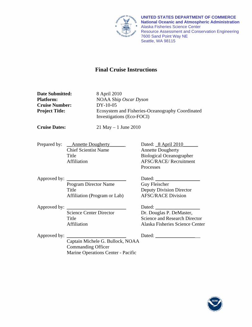
UNITED STATES DEPARTMENT OF COMMERCE National Oceanic and Atmospheric Administration Alaska Fisheries Science Center Resource Assessment and Conservation Engineering 7600 Sand Point Way NE Seattle, WA 98115
Final Cruise Instructions
Date Submitted: 8 April 2010 Platform: NOAA Ship Oscar Dyson Cruise Number: DY-10-05 Project Title: Ecosystem and Fisheries-Oceanography Coordinated
Investigations (Eco-FOCI)
Cruise Dates: 21 May – 1 June 2010
Prepared by: __Annette Dougherty______ Dated: _8 April 2010______ Chief Scientist Name Annette Dougherty Title Biological Oceanographer Affiliation AFSC/RACE/ Recruitment
Processes Approved by: ________________________ Dated: __________________ Program Director Name Guy Fleischer Title Deputy Division Director Affiliation (Program or Lab) AFSC/RACE Division Approved by: ________________________ Dated: __________________ Science Center Director Dr. Douglas P. DeMaster, Title Science and Research Director Affiliation Alaska Fisheries Science Center Approved by: ________________________ Dated: ________________ Captain Michele G. Bullock, NOAA Commanding Officer Marine Operations Center - Pacific

I. Cruise Overview
A Departure: Depart Dutch Harbor, Alaska, at 1500 hours on Friday, May 21, 2010.
Arrival: Arrive Kodiak Island, Alaska, at 0800 hours on Tuesday, June 1, 2010.
B. Operating Area: Gulf of Alaska
C. Summary of Objectives: The objectives of this cruise are to conduct an ichthyoplankton survey and process studies in the region between the Shumagin Islands and Shelikof Strait so that we may estimate the abundance, transport, and factors influencing the survival of young walleye pollock larvae. We will also occupy stations on Line 8 to continue our 25-year time series of environmental and biological conditions in Shelikof Strait.
D. Participating Institutions: NOAA – Alaska Fisheries Science Center (AFSC) 7600 Sand Point Way N.E. Seattle, Washington 98115-6349
E. Personnel (Science Party):
Name Gender Affiliation Title Citizenship
Annette Dougherty Female AFSC Chief Scientist USA Kevin Bailey Male AFSC Research Fisheries Biologist USA Steve Porter Male AFSC Research Fisheries Biologist USA
Tiffany Vance Female AFSC IT Specialist USA Laura Rodriguez Female Teacher-At-Sea USA
F. Administrative
1. Points of Contacts: Chief Scientist
Annette Dougherty NOAA – Fisheries, Alaska Fisheries Science Center 7600 Sand Point Way NE Seattle, WA 98115 (206) 526-6523 (V); (206) 526-6723 (FAX) [email protected]
Field Operations Officer LT Sarah Duncan,
1

NOAA Ship Oscar Dyson (206) 295-0550 (Cell) [email protected]
2. Diplomatic Clearances: N/A 3. Licenses and Permits:
DOC/NOAA/Scientific Research Permit #2010-B1 State of Alaska, Fisheries Research Permit (pending)
II. Operations
A. Cruise Plan/Itinerary Date Activity
May 20 Embark 4 Scientists and 1 teacher-at-sea in Dutch Harbor, Alaska
May 21 Depart Dutch Harbor 1500 hrs and proceed to first station in Shumagin Islands
June 1 Arrive Kodiak Island 0800 hrs; disembark Scientists
B. Staging and Destaging:
1. Staging Plan – All equipment necessary for the cruise will be loaded onto the NOAA Ship OSCAR DYSON on May 5th in Dutch Harbor. During the cruise we will require dedicated use of the wet, chemistry, and dry labs for sample and equipment preparation and request as much counter and cabinet space as is possible.
2. De-staging Plan – AFSC personnel will off-load EcoFOCI gear and samples from
NOAA Ship Oscar Dyson while the ship is Kodiak Island, Alaska the morning of June 1. The scientific party will need assistance from the vessel (crane operator) to off-load the gear and samples. These will be be picked up by a contracted shipping company.
C. Operations to be Conducted: We will conduct operations 24/7.
1. Underway Operations --– The ship's Scientific Computer System (SCS) shall operate throughout the cruise, acquiring and logging data from navigation, meteorological, and oceanographic sensors. See FOCI Standard Operating Instructions (SOI 5.2 and SOI 5.3) for specific requirements at http://www.pmel.noaa.gov/foci/operations/cruise_docs/FOCI_OD_SOI.pdf.
2. Station Operations – An ichthyoplankton survey will be conducted from the Shumagin Islands to Shelikof Strait. A total of 146 stations are planned. The
2

standard gear for this survey will be a 60-cm bongo (SOI 3.2.2) with 0.505-mm mesh netting. A SEACAT SBE19plus will be mounted above the bongo to provide depth, temperature, and salinity data. Tows will be to 100 meters or 10 meters off the bottom where water depth is shallower. Operations will begin at Line 135 (HB135) and proceed upstream to Line 185. Live tows may be conducted with the bongos to examine larval walleye pollock condition if larvae ≤ 8-mm are found. While we are working up the grid toward Kodiak Island, we will occupy stations on Line 8. Line 8 sampling will include 20-cm and 60-cm bongos and conductivity, temperature, and depth (CTD) (SOI 3.2.1) profiles with Niskin bottle samples for chlorophyll, microzooplankton, and nutrients. Net tows at Line 8 are to 10 meters off the bottom. The 60-cm bongo will be fitted with 0.505-mm and 0.333-mm mesh nets for Line 8 sampling while the 20-cm bongo mesh will be 0.153-mm. On completion of Line 8, the 60-cm bongo will be refitted with the 0.505-mm mesh netting and cod ends on both sides of the frame and sampling will resume as before.
The samples collected from the 60-cm bongos (except for Line 8) will be processed in the following manner. Net 1 will be preserved in 1.8% formaldehyde, buffered with sodium borate, and boxed for shipment at the end of the survey. Net 2 samples will be sorted for walleye pollock larvae and all other fish larvae and preserved in 95% and 100% ethanol, respectively. The rest of Net 2 will be discarded unless otherwise requested. Both nets from the 60-cm bongo samples collected from Line 8 will be preserved in 1.8% formaldehyde and buffered with sodium borate. From the 20-cm bongo, only net 1 will be preserved in buffered 1.8% formaldehyde. Marks to the MOA will be made in the Survey Office (Dry Lab) by a scientist on-watch who will be monitoring the SEACAT operation throughout the station occupation. Marks will be made at surface-in, at-depth, and surface-out. The processing of SEACAT files will be the responsibility of the scientific personnel on watch.
D. Dive Plan -- N/A
E. Applicable Restrictions -- None known
III. Facilities
A. Equipment and Capabilities Provided by the Ship:
• Hydrographic winch with slip rings and 3-conductor cable terminated for CTD, • Manual wire angle indicator,
3

• Hydrographic winch with slip rings and 3-conductor cable terminated for the SBE-19 + SEACAT, for net tow operations,
• Sea-Bird Electronics SBE-19plus SEACAT system, • Sea-Bird Electronics SBE 911plus CTD system with rosette, each CTD system
should include underwater CTD, weights, and pinger. There should be one deck unit for the two systems,
• Conductivity and temperature sensor package to provide dual sensors on the CTD (primary),
• Niskin Bottles: at least (4) 10 liter bottles, and as many as are available • Underway fluorometer, • Wire speed indicators and readout for both hydrographic winches visible in Dry
Lab where SEACAT operations occur, • For meteorological observations: 2 anemometers (one R. M. Young system
interfaced to the SCS), calibrated air thermometer (wet-and dry-bulb) and a calibrated barometer and/or barograph,
• Freezer space for storage of biological and chemical samples (both blast and storage freezers, -20° C and -80° C) turned on and operating,
• SIMRAD ES-60 and SIMRAD EK-60 echosounders, • Use of Pentium PC in Dry and/or Computer Lab for data analysis, • Scientific Computer System (SCS), • Video monitors in Dry, Chemistry, and Wet labs for viewing SCS and Electronic
MOA output, • Laboratory space with exhaust hood, sink, lab tables, and storage space, • Sea-water hoses and spray nozzles to wash nets (quarterdeck), • Adequate deck lighting for night-time operations, • Navigational equipment including GPS and radar, • Safety harnesses for working on starboard sampling station/hero platform, and • Ship’s crane(s) used for loading and/or deploying gear and supplies.
B. Equipment and Capabilities Provided by the Scientists:
• Sea-Bird Electronics SBE 911plus CTD system (backup) (PMEL), • Sea-Bird Electronics’ SBE-19plus SEACAT system, (backup) (AFSC), • PMEL PC with SEASOFT software for CTD data collection and processing, • Fluorometer, light meter, and 02 sensor to be mounted on CTD, • CTD stand modified for attachment of fluorometer, • Conductivity and temperature sensor package to provide dual sensors on the CTD
(backup), • CTD rosette sampler, • 5 liter Niskin bottles (6) • 20-cm and 60-cm Bongo sampling arrays, • Sameoto neuston net and frame, • Manual wire-angle indicator, • Spare manual wire angle indicator,
4

• Miscellaneous scientific sampling and processing equipment, • Microscopes for examining, sorting, and measuring fish eggs and larvae, • Cruise Operations Database (COD) software and forms, and • Miscellaneous scientific sampling and processing equipment.
IV. Hazardous Materials
A. Policy and Compliance: The Chief Scientist is responsible for complying with MOCDOC 15, Fleet Environmental Compliance #07, Hazardous Material and Hazardous Waste Management Requirements for Visiting Scientists, released July 2002. Documentation regarding those requirements will be provided by the Chief of Operations, Marine Operations Center, upon request.
By Federal regulations and NOAA Marine and Aviation Operations policy, the ship may not sail without a complete inventory of all hazardous materials by name and the anticipated quantity brought aboard, MSDS and appropriate neutralizing agents, buffers, and/or absorbents in amounts adequate to address spills of a size equal to the amount of chemical brought aboard. The amount of hazardous material arriving and leaving the vessel shall be accounted for by the Chief Scientist.
B. Radioactive Isotopes: N/A
C. HazMat Inventory:
Chemical CAS
Number Respondee Org. Qty H F R
Storage Color Code
Hazard Class
Packing Group
Number UN
Reportable Quantity
Response Indices
Formaldehyde 37%
50-00-0 Napp AFSC 3,
20-L
3 2 2 Flammable 3 & 8 III 1198 100 LBS 1
Reagent Alcohol 95%
N/A Napp AFSC 2, 4-
L 3 3 1 Flammable 3 II, III 1187 1
Ethyl Alcohol 100% Genetic Grade
64-17-5 Napp AFSC 2, 4-
L 2 3 1 Flammable 3 II, III 1170 1
Ethylene glycol
107-21-1
Napp AFSC 1,
250- ml
2 1 1 General Not
regulated N/A 5,000 lbs 2
Sodium Borate Solution, Saturated
mix Napp AFSC 20-L 1 0 0 General
Not regulated
N/A 2
5
V. Additional Projects
A. Supplementary (“Piggyback”) Projects: N/A
B. NOAA Fleet Ancillary Projects: N/A
VI. Disposition of Data and Reports
A. Data Responsibilities: The following data products will be supplied by the vessel and included in the cruise data package:
NOAA Form 77-13d – Deck Log – Weather Observation Sheets, Electronic Marine Operations Abstracts, SCS backup – recordable compact diskette (CD-RW), Calibration Sheets for all ship's and scientific instruments used, PMEL CTD weather observation log CTD Cast Information/Rosette Log, Scientific Freezer Temperature Daily Log, and Controlled Environmental Room Temperature Log.
B. Pre and Post Cruise Meeting:
Cruise meetings may be held in accordance with FOCI Standard Operating Instructions (SOI 5.5).
Pre-Cruise Meeting: Prior to departure, the Chief Scientist will conduct a meeting of the scientific party to train them in sample collection and inform them of cruise objectives. Some vessel protocols, e.g., meals, watches, etiquette, etc. will be presented by the ship’s Operations Officer.
Post-Cruise Meeting: Upon completion of the cruise, a meeting will normally be held at 0830 hrs (unless prior alternate arrangements are made) and attended by the ship’s officers, the Chief Scientist and members of the scientific party, the Vessel Coordinator and the Port Captain to review the cruise. Concerns regarding safety, efficiency, and suggestions for improvements for future cruises should be discussed. Minutes of the post-cruise meeting will be distributed to all participants by email, and to the Commanding Officer and Chief of Operations, Marine Operations Center.
C. Ship Operation Evaluation Report:
Within seven days of the completion of the cruise, a Ship Operation Evaluation form is to be completed by the Chief Scientist. The preferred method of transmittal of this form is via email to [email protected]. If email is not an option, a hard copy may be forwarded to:
6
Director, NOAA Marine and Aviation Operations 8403 Colesville Road, Suite 500 Silver Spring, MD 20910
VII. Miscellaneous
A. Miscellaneous – Meals and Berthing:
Meals and berthing are required for up to 4 scientists. Meals will be served 3 times daily beginning one hour before scheduled departure, extending throughout the cruise, and ending two hours after the termination of the cruise. Since the watch schedule is split between day and night, the night watch may often miss daytime meals and will require adequate food and beverages (for example a variety of sandwich items, cheeses, fruit, milk, juices) during what are not typically meal hours. Special dietary requirements for scientific participants will be made available to the ship’s command at least seven days prior to the survey.
Berthing requirements, including number and gender of the scientific party, will be provided to the ship by the Chief Scientist. The Chief Scientist and Commanding Officer will work together on a detailed berthing plan to accommodate the gender mix of the scientific party taking into consideration the current make-up of the ship’s complement. The Chief Scientist is responsible for ensuring the scientific berthing spaces are left in the condition in which they were received; for stripping bedding and linen return; and for the return of any room keys which were issued. The Chief Scientist is also responsible for the cleanliness of the laboratory spaces and the storage areas utilized by the scientific party, both during the cruise and at its conclusion prior to departing the ship.
All NOAA scientists will have proper travel orders when assigned to any NOAA ship. The Chief Scientist will ensure that all non NOAA or non Federal scientists aboard also have proper orders. It is the responsibility of the Chief Scientist to ensure that the entire scientific party has a mechanism in place to provide lodging and food and to be reimbursed for these costs in the event that the ship becomes uninhabitable and/or the galley is closed during any part of the scheduled project.
All persons boarding NOAA vessels give implied consent to comply with all safety and security policies and regulations which are administered by the Commanding Officer. All spaces and equipment on the vessel are subject to inspection or search at any time. All personnel must comply with OMAO's Drug and Alcohol Policy dated May 7, 1999 that forbids the possession and/or use of illegal drugs and alcohol aboard NOAA Vessels.
B. Miscellaneous – Medical Forms and Emergency Contacts:
The NOAA Health Services Questionnaire (NHSQ, Revised: 08/08) must be completed in advance by each participating scientist. The NHSQ can be obtained from the Chief Scientist or the NOAA website at http://www.omao.noaa.gov/medical/NHSQ_Final_wi_Instructions_fill.pdf. The completed form should be sent to the Regional Director of Health Services at Marine
7

Operations Center. The participant can mail, fax, or scan the form into an email using the contact information below. The NHSQ should reach the Health Services Office no later than 4 weeks prior to the cruise to allow time for the participant to obtain and submit additional information that health services might require before clearance to sail can be granted. Please contact MOC Health Services with any questions regarding eligibility or completion of the NHSQ. Be sure to include proof of tuberculosis (TB) testing, sign and date the form, and indicate the ship or ships the participant will be sailing on. The participant will receive an email notice when medically cleared to sail if a legible email address is provided on the NHSQ.
Contact information:
Regional Director of Health Services Regional Director of Health Services Marine Operations Center – Atlantic Marine Operations Center - Pacific 439 W. York Street 1801 Fairview Avenue East Norfolk, VA 23510 Seattle, WA 98102 Telephone 757.441.6320 Telephone 206.553.8704 Fax 757.441.3760 Fax 206.553.1112 E-mail [email protected] Email [email protected]
Prior to departure, the Chief Scientist must provide a listing of emergency contacts to the Executive Officer for all members of the scientific party, with the following information: name, address, relationship to member, and telephone number.
C. Miscellaneous – Shipboard Safety
Wearing open-toed footwear or shoes that do not completely enclose the foot (such as sandals or clogs) outside of private berthing areas is not permitted. Steel-toed shoes are required to participate in any work dealing with suspended loads, including CTD deployments and recovery. The ship does not provide steel-toed boots. Hard hats are also required when working with suspended loads. Work vests are required when working near open railings and during small boat launch and recovery operations. Hard hats and work vests will be provided by the ship when required.
8
Miscellaneous – Communications
A progress report on operations prepared by the Chief Scientist may be relayed to the program office. Sometimes it is necessary for the Chief Scientist to communicate with another vessel, aircraft, or shore facility. Through various modes of communication, the ship is able to maintain contact with the Marine Operations Center on an as needed basis. These methods will be made available to the Chief Scientist upon request, in order to conduct official business. Due to a new directive from Marine Operations Center, the ship must charge the science party for all calls made on the cell or sky-cell telephone. INMARSAT, Sky Cell and cellular communication costs shall be reimbursed to the ship for telephone calls made by all scientific personnel. Currently, Sky Cell and cellular telephone services are about $0.89 per minute and INMARSAT MiniM is around $1.68 per minute for voice. These charges will be assessed against the program after the ship receives the bill. There is generally a three month delay receiving the bill for review. The Chief Scientist will be required to keep a log of all calls made by the science party.
NOAA Ship OSCAR DYSON – Telephone methods listed in order of increasing expense.
United States Coast Guard – Kodiak, Alaska: • (907) 487-9752 • (907) 487-9753 • (907) 487-4397 • (907) 487-4398
Cellular: • (206) 604-7122 (CO) • (206) 295-0775 (XO) • (206) 295-0550 (OPS) • (206) 295-0670 (CME)
Wavetalk • 1-800-668-4950-toll free
INMARSAT B: • 011-872-336-995-910 (voice line 1) • 011-872-336-995-920 (voice line 2) • 011-872-336-995-911 (fax)
Iridium: 011-8816-7631-0050
E-Mail: [email protected] (mention the person’s name in SUBJECT field.)
Operations Division (MOP1)
• (206) 553-4548 (voice) • (206) 553-1109 (facsimile)
E-Mail: [email protected]
9

D. Miscellaneous – IT Security
Any computer that will be hooked into the ship's network must comply with the NMAO Fleet IT Security Policy prior to establishing a direct connection to the NOAA WAN. Requirements include, but are not limited to:
(1) Installation of the latest virus definition (.DAT) file on all systems and performance of a virus scan on each system. (2) Installation of the latest critical operating system security patches. (3) No external public Internet Service Provider (ISP) connections.
Completion of these requirements prior to boarding the ship is preferable.
Non-NOAA personnel using the ship's computers or connecting their own computers to the ship's network must complete NOAA’s IT Security Awareness Course within 3 days of embarking.
F. Foreign National Guests Access to OMAO Facilities and Platforms: N/A
10

Appendices
Figure 1. Potential grid stations for DY10-05.
11
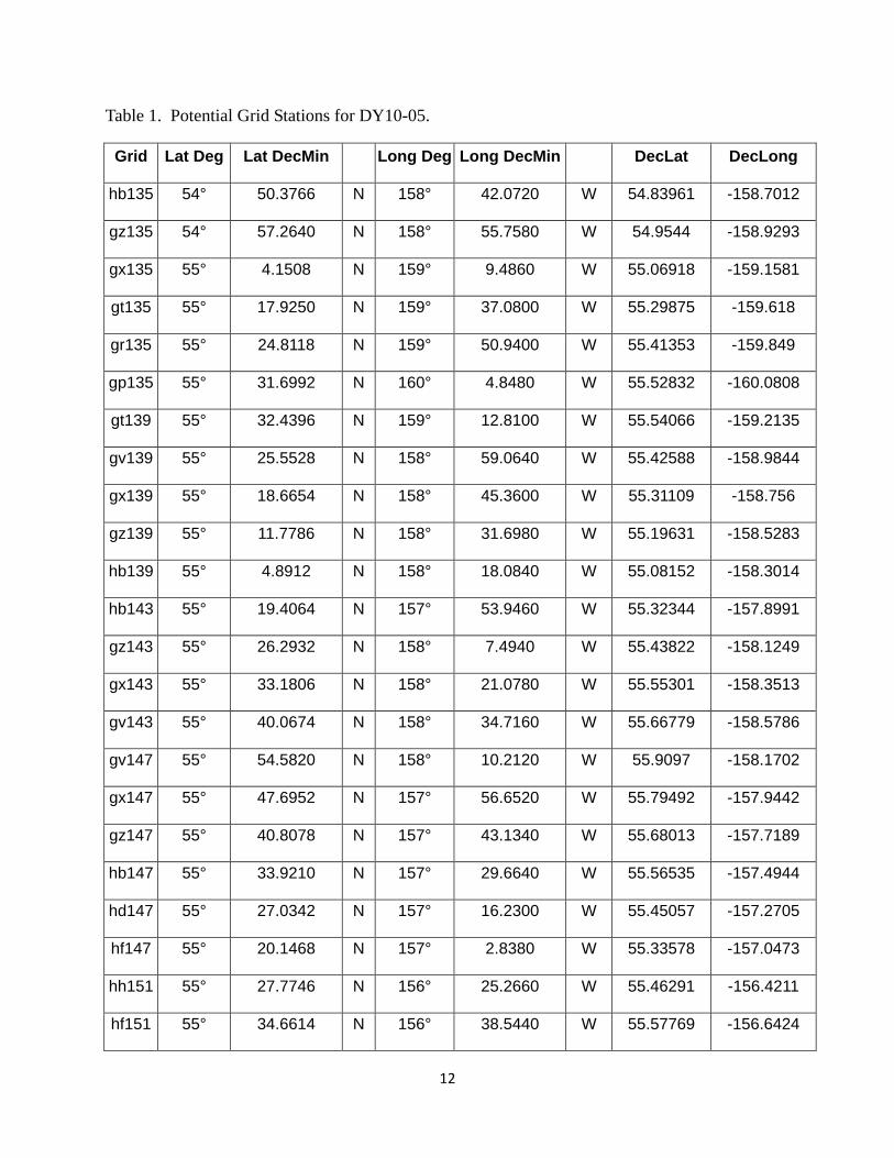
Table 1. Potential Grid Stations for DY10-05.
Grid Lat Deg Lat DecMin Long Deg Long DecMin DecLat DecLong
hb135 54° 50.3766 N 158° 42.0720 W 54.83961 -158.7012
gz135 54° 57.2640 N 158° 55.7580 W 54.9544 -158.9293
gx135 55° 4.1508 N 159° 9.4860 W 55.06918 -159.1581
gt135 55° 17.9250 N 159° 37.0800 W 55.29875 -159.618
gr135 55° 24.8118 N 159° 50.9400 W 55.41353 -159.849
gp135 55° 31.6992 N 160° 4.8480 W 55.52832 -160.0808
gt139 55° 32.4396 N 159° 12.8100 W 55.54066 -159.2135
gv139 55° 25.5528 N 158° 59.0640 W 55.42588 -158.9844
gx139 55° 18.6654 N 158° 45.3600 W 55.31109 -158.756
gz139 55° 11.7786 N 158° 31.6980 W 55.19631 -158.5283
hb139 55° 4.8912 N 158° 18.0840 W 55.08152 -158.3014
hb143 55° 19.4064 N 157° 53.9460 W 55.32344 -157.8991
gz143 55° 26.2932 N 158° 7.4940 W 55.43822 -158.1249
gx143 55° 33.1806 N 158° 21.0780 W 55.55301 -158.3513
gv143 55° 40.0674 N 158° 34.7160 W 55.66779 -158.5786
gv147 55° 54.5820 N 158° 10.2120 W 55.9097 -158.1702
gx147 55° 47.6952 N 157° 56.6520 W 55.79492 -157.9442
gz147 55° 40.8078 N 157° 43.1340 W 55.68013 -157.7189
hb147 55° 33.9210 N 157° 29.6640 W 55.56535 -157.4944
hd147 55° 27.0342 N 157° 16.2300 W 55.45057 -157.2705
hf147 55° 20.1468 N 157° 2.8380 W 55.33578 -157.0473
hh151 55° 27.7746 N 156° 25.2660 W 55.46291 -156.4211
hf151 55° 34.6614 N 156° 38.5440 W 55.57769 -156.6424
12
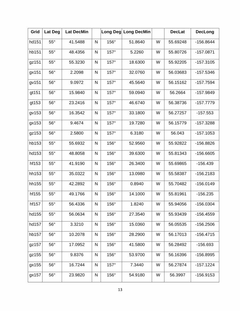
Grid Lat Deg Lat DecMin Long Deg Long DecMin DecLat DecLong
hd151 55° 41.5488 N 156° 51.8640 W 55.69248 -156.8644
hb151 55° 48.4356 N 157° 5.2260 W 55.80726 -157.0871
gz151 55° 55.3230 N 157° 18.6300 W 55.92205 -157.3105
gx151 56° 2.2098 N 157° 32.0760 W 56.03683 -157.5346
gv151 56° 9.0972 N 157° 45.5640 W 56.15162 -157.7594
gt151 56° 15.9840 N 157° 59.0940 W 56.2664 -157.9849
gt153 56° 23.2416 N 157° 46.6740 W 56.38736 -157.7779
gv153 56° 16.3542 N 157° 33.1800 W 56.27257 -157.553
gx153 56° 9.4674 N 157° 19.7280 W 56.15779 -157.3288
gz153 56° 2.5800 N 157° 6.3180 W 56.043 -157.1053
hb153 55° 55.6932 N 156° 52.9560 W 55.92822 -156.8826
hd153 55° 48.8058 N 156° 39.6300 W 55.81343 -156.6605
hf153 55° 41.9190 N 156° 26.3400 W 55.69865 -156.439
hh153 55° 35.0322 N 156° 13.0980 W 55.58387 -156.2183
hh155 55° 42.2892 N 156° 0.8940 W 55.70482 -156.0149
hf155 55° 49.1766 N 156° 14.1000 W 55.81961 -156.235
hf157 55° 56.4336 N 156° 1.8240 W 55.94056 -156.0304
hd155 55° 56.0634 N 156° 27.3540 W 55.93439 -156.4559
hd157 56° 3.3210 N 156° 15.0360 W 56.05535 -156.2506
hb157 56° 10.2078 N 156° 28.2900 W 56.17013 -156.4715
gz157 56° 17.0952 N 156° 41.5800 W 56.28492 -156.693
gz155 56° 9.8376 N 156° 53.9700 W 56.16396 -156.8995
gx155 56° 16.7244 N 157° 7.3440 W 56.27874 -157.1224
gx157 56° 23.9820 N 156° 54.9180 W 56.3997 -156.9153
13

Grid Lat Deg Lat DecMin Long Deg Long DecMin DecLat DecLong
gv155 56° 23.6118 N 157° 20.7540 W 56.39353 -157.3459
gt155 56° 30.4986 N 157° 34.2120 W 56.50831 -157.5702
gu158 56° 40.0000 N 157° 13.0000 W 56.6666667 -157.21667
gv159 56° 38.1264 N 156° 55.7880 W 56.63544 -156.9298
gx159 56° 31.2396 N 156° 42.4500 W 56.52066 -156.7075
gz159 56° 24.3522 N 156° 29.1540 W 56.40587 -156.4859
hb159 56° 17.4654 N 156° 15.9000 W 56.29109 -156.265
hd159 56° 10.5780 N 156° 2.6820 W 56.1763 -156.0447
hf159 56° 3.6912 N 155° 49.5060 W 56.06152 -155.8251
hd161 56° 17.8356 N 155° 50.2920 W 56.29726 -155.8382
hb161 56° 24.7224 N 156° 3.4680 W 56.41204 -156.0578
gz161 56° 31.6098 N 156° 16.6860 W 56.52683 -156.2781
gx161 56° 38.4966 N 156° 29.9460 W 56.64161 -156.4991
gv161 56° 45.3840 N 156° 43.2480 W 56.7564 -156.7208
gv163 56° 52.6410 N 156° 30.6660 W 56.87735 -156.5111
gx163 56° 45.7542 N 156° 17.4000 W 56.76257 -156.29
gz163 56° 38.8674 N 156° 4.1820 W 56.64779 -156.0697
hb163 56° 31.9800 N 155° 51.0000 W 56.533 -155.85
hd163 56° 25.0932 N 155° 37.8600 W 56.41822 -155.631
hd165 56° 32.3502 N 155° 25.3860 W 56.53917 -155.4231
hb165 56° 39.2376 N 155° 38.4900 W 56.65396 -155.6415
gz165 56° 46.1244 N 155° 51.6360 W 56.76874 -155.8606
gx165 56° 53.0118 N 156° 4.8180 W 56.88353 -156.0803
gv165 56° 59.8986 N 156° 18.0420 W 56.99831 -156.3007
14

Grid Lat Deg Lat DecMin Long Deg Long DecMin DecLat DecLong
gv167 57° 7.1562 N 156° 5.3760 W 57.11927 -156.0896
gx167 57° 0.2688 N 155° 52.1880 W 57.00448 -155.8698
gz167 56° 53.3820 N 155° 39.0480 W 56.8897 -155.6508
hb167 56° 46.4946 N 155° 25.9440 W 56.77491 -155.4324
hd167 56° 39.6078 N 155° 12.8760 W 56.66013 -155.2146
hd169 56° 46.8654 N 155° 0.3240 W 56.78109 -155.0054
hb169 56° 53.7522 N 155° 13.3500 W 56.89587 -155.2225
gz169 57° 0.6390 N 155° 26.4180 W 57.01065 -155.4403
gx169 57° 7.5264 N 155° 39.5220 W 57.12544 -155.6587
gv169 57° 14.4132 N 155° 52.6680 W 57.24022 -155.8778
gt169 57° 21.3000 N 156° 5.0000 W 57.355 -156.08333
gt171 57° 27.0000 N 155° 46.0000 W 57.45 -155.76667
gv171 57° 21.6708 N 155° 39.9180 W 57.36118 -155.6653
gx171 57° 14.7840 N 155° 26.8140 W 57.2464 -155.4469
gz171 57° 7.8966 N 155° 13.7460 W 57.13161 -155.2291
hb171 57° 1.0098 N 155° 0.7200 W 57.01683 -155.012
hd171 56° 54.1224 N 154° 47.7360 W 56.90204 -154.7956
hd173 57° 1.3800 N 154° 35.1060 W 57.023 -154.5851
hb173 57° 8.2668 N 154° 48.0480 W 57.13778 -154.8008
gz173 57° 15.1542 N 155° 1.0380 W 57.25257 -155.0173
gx173 57° 22.0410 N 155° 14.0640 W 57.36735 -155.2344
gv173 57° 28.9284 N 155° 27.1260 W 57.48214 -155.4521
gt173 57° 37.0000 N 155° 28.0000 W 57.6166667 -155.46667
gv175 57° 36.1854 N 155° 14.2980 W 57.60309 -155.2383
15

Grid Lat Deg Lat DecMin Long Deg Long DecMin DecLat DecLong
gx175 57° 29.2986 N 155° 1.2720 W 57.48831 -155.0212
gz175 57° 22.4112 N 154° 48.2820 W 57.37352 -154.8047
FOX56 57° 31.2000 N 154° 46.8000 W 57.52 -154.78
FOX57 57° 33.0000 N 154° 52.8000 W 57.55 -154.88
FOX58 57° 36.6000 N 155° 0.6000 W 57.61 -155.01
FOX59 57° 38.4000 N 155° 4.2000 W 57.64 -155.07
FOX60 57° 40.8000 N 155° 10.2000 W 57.68 -155.17
FOX61 57° 43.2000 N 155° 15.6000 W 57.72 -155.26
gx177 57° 36.5556 N 154° 48.4380 W 57.60926 -154.8073
gv177 57° 43.4430 N 155° 1.4220 W 57.72405 -155.0237
gv179 57° 50.7006 N 154° 48.4980 W 57.84501 -154.8083
gx179 57° 43.8132 N 154° 35.5620 W 57.73022 -154.5927
gz181 57° 44.1834 N 154° 9.7740 W 57.73639 -154.1629
gx181 57° 51.0708 N 154° 22.6380 W 57.85118 -154.3773
gx183 57° 58.3278 N 154° 9.6720 W 57.97213 -154.1612
gz183 57° 51.4410 N 153° 56.8500 W 57.85735 -153.9475
gz185 57° 58.6986 N 153° 43.8840 W 57.97831 -153.7314
gx185 58° 5.5854 N 153° 56.6640 W 58.09309 -153.9444
gx187 58° 12.8430 N 153° 43.6140 W 58.21405 -153.7269
gz187 58° 5.9556 N 153° 30.8700 W 58.09926 -153.5145
gz189 58° 13.2132 N 153° 17.8200 W 58.22022 -153.297
gx189 58° 20.1000 N 153° 30.5160 W 58.335 -153.5086
gv189 58° 26.9874 N 153° 43.2480 W 58.44979 -153.7208
gv191 58° 34.2444 N 153° 30.0660 W 58.57074 -153.5011
16

Grid Lat Deg Lat DecMin Long Deg Long DecMin DecLat DecLong
gx191 58° 27.3576 N 153° 17.3700 W 58.45596 -153.2895
gz191 58° 20.4708 N 153° 4.7160 W 58.34118 -153.0786
gz193 58° 27.7278 N 152° 51.5760 W 58.46213 -152.8596
gx193 58° 34.6152 N 153° 4.1820 W 58.57692 -153.0697
gv193 58° 41.5020 N 153° 16.8300 W 58.6917 -153.2805
gv195 58° 48.7596 N 153° 3.5580 W 58.81266 -153.0593
gx195 58° 41.8722 N 152° 50.9520 W 58.69787 -152.8492
gz197 58° 42.2424 N 152° 25.1460 W 58.70404 -152.4191
gz199 58° 49.5000 N 152° 11.8680 W 58.825 -152.1978
hb199 58° 42.6132 N 151° 59.4180 W 58.71022 -151.9903
hd199 58° 35.7258 N 151° 47.0100 W 58.59543 -151.7835
hd197 58° 28.4688 N 152° 0.2040 W 58.47448 -152.0034
hf197 58° 21.5814 N 151° 47.7840 W 58.35969 -151.7964
hf199 58° 28.8390 N 151° 34.6320 W 58.48065 -151.5772
hh199 58° 21.9516 N 151° 22.2900 W 58.36586 -151.3715
hj199 58° 15.0648 N 151° 9.9840 W 58.25108 -151.1664
hj197 58° 7.8072 N 151° 23.0460 W 58.13012 -151.3841
hh197 58° 14.6946 N 151° 35.4000 W 58.24491 -151.59
hh195 58° 7.4370 N 151° 48.4620 W 58.12395 -151.8077
hj195 58° 0.5502 N 151° 36.0720 W 58.00917 -151.6012
17
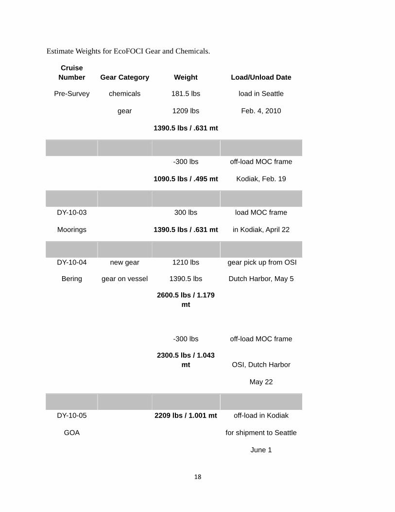
Estimate Weights for EcoFOCI Gear and Chemicals.
Cruise Number Gear Category Weight Load/Unload Date
Pre-Survey chemicals 181.5 lbs load in Seattle
gear 1209 lbs Feb. 4, 2010
1390.5 lbs / .631 mt
-300 lbs off-load MOC frame
1090.5 lbs / .495 mt Kodiak, Feb. 19
DY-10-03 300 lbs load MOC frame
Moorings 1390.5 lbs / .631 mt in Kodiak, April 22
DY-10-04 new gear 1210 lbs gear pick up from OSI
Bering gear on vessel 1390.5 lbs Dutch Harbor, May 5
2600.5 lbs / 1.179
mt
-300 lbs off-load MOC frame
2300.5 lbs / 1.043
mt OSI, Dutch Harbor
May 22
DY-10-05 2209 lbs / 1.001 mt off-load in Kodiak
GOA for shipment to Seattle
June 1
18
19
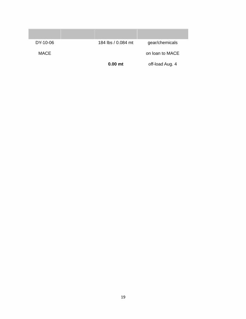
DY-10-06 184 lbs / 0.084 mt gear/chemicals
MACE on loan to MACE
0.00 mt off-load Aug. 4