final annual report summary of the sopac secretariat (2010)
TRANSCRIPT

FINAL ANNUAL REPORT SUMMARY OF THE SOPAC SECRETARIAT 2010 1
FINAL ANNUAL REPORT SUMMARY OF THE SOPAC SECRETARIAT
2010
SOPAC
P a c i f i c I s l a n d s A p p l i e d G e o s c i e n c e C o m m i s s i o n

A
Member Countries
American Samoa (Associate)Australia
Cook IslandsFederated States of Micronesia
Fiji IslandsFrench Polynesia (Associate)
GuamKiribati
Marshall IslandsNauru
New Caledonia (Associate)New Zealand
NiuePalau
Papua New GuineaSamoa
Solomon IslandsTokelau (Associate)
TongaTuvalu
Vanuatu
Overall Vision:Natural Resources, principally non-living resources, developed in a
sustainable manner and resilience ofPacific peoples strengthened
DISCLAIMERThe mention of products, technologies, companies does not
imply recommendation or endorsement by SOPAC, neither does it imply that these are necessarily the best available for the purpose.
Published by the Pacific Islands Applied Geoscience Commission (SOPAC)
June 2011
SOPAC Secretariat Private Mail Bag
GPO SuvaFiji Islands
website: www.sopac.orgemail: [email protected]
SOPAC

contentsPREFACE
DIRECTOR’S 2010 REPORT
Foreword
The Suspension of SOPAC “The Commission” & The Conclusion of the RIF Process Pertaining to SOPAC
Highlights from Work Programme Implementation
WORK PROGRAMME REPORTS 2010
(Note in transition and due to the formulation of the new Strategic Plan; and the transfer of certain functions of SOPAC to other organizations, Programme title changes were effected mid-year in 2010)
Ocean and Islands Programme
Water and Sanitation Programme
Disaster Reduction Programme
Technical Support Services
APPENDICES
Summary of 2010 Donor Funding – 1
Reports and Publications Update – 2
Secretariat Staff List – 3
Acronyms – 4
The RIF Records Pertaining to SOPAC – 5
ii iii
iv
vi
ix
1
3
20
36
65
7980
81
85
89
CD
FIN
AL
AN
NU
AL
REP
OR
T S
UM
MA
RY
OF
TH
E S
OP
AC
SEC
RET
AR
IAT
20
10

FINAL ANNUAL REPORT SUMMARY OF THE SOPAC SECRETARIAT 2010ii
The Pacific Islands Applied Geoscience Commission will be suspended “on or before 30 September 2011” once its final set of audited accounts are approved according to the method set out by the SOPAC Governing Council at its final meeting in October 2010.
Its work programmes have transferred and are operational in the new Applied Geoscience and Technology Division of the Secretariat of the Pacific Community (SPC); which began its life on 1 January 2011.
Given these developments, this document as the final Annual Report of the Secretariat of the Pacific Islands Applied Geoscience Commission will depart slightly from its traditional contents for the purpose of ensuring the records of the regional institutional reforms requested by Pacific Islands Forum Leaders and pertaining to the Commission are published in the public domain; and will be part of its historical records.
The part of the annual report contributed by the Director, which normally consists of only a Foreword will be more substantial with three parts: the Foreword; a section on the Suspension of the Commission; and a section on managing Work Programme delivery against the backdrop of crossing the bridge into SPC.
Furthermore, appended to this annual report is a CD containing all documentation out of consultations and reports that issued out of implementation of the Pacific Leaders’ instruction in 2007 to “rationalise the functions of the Pacific Islands Applied Geoscience Commission (SOPAC) with the work programmes of the Secretariat of the Pacific Community (SPC) and the Secretariat of the Pacific Regional Environment Programme (SPREP) with the view to absorbing those functions of SOPAC into SPC and SPREP”. Most of said documentation is presently accessible online on the RIF page of the SPC-SOPAC Division website, but the CD will also include restricted documents not available on the RIF page.
SOPAC Secretariat June 2011
Preface

FINAL ANNUAL REPORT SUMMARY OF THE SOPAC SECRETARIAT 2010 iii
Director’s 2010 REPORT
Four seeds you need to sow, One for the rook and one for the crow,
One to die and one to grow.
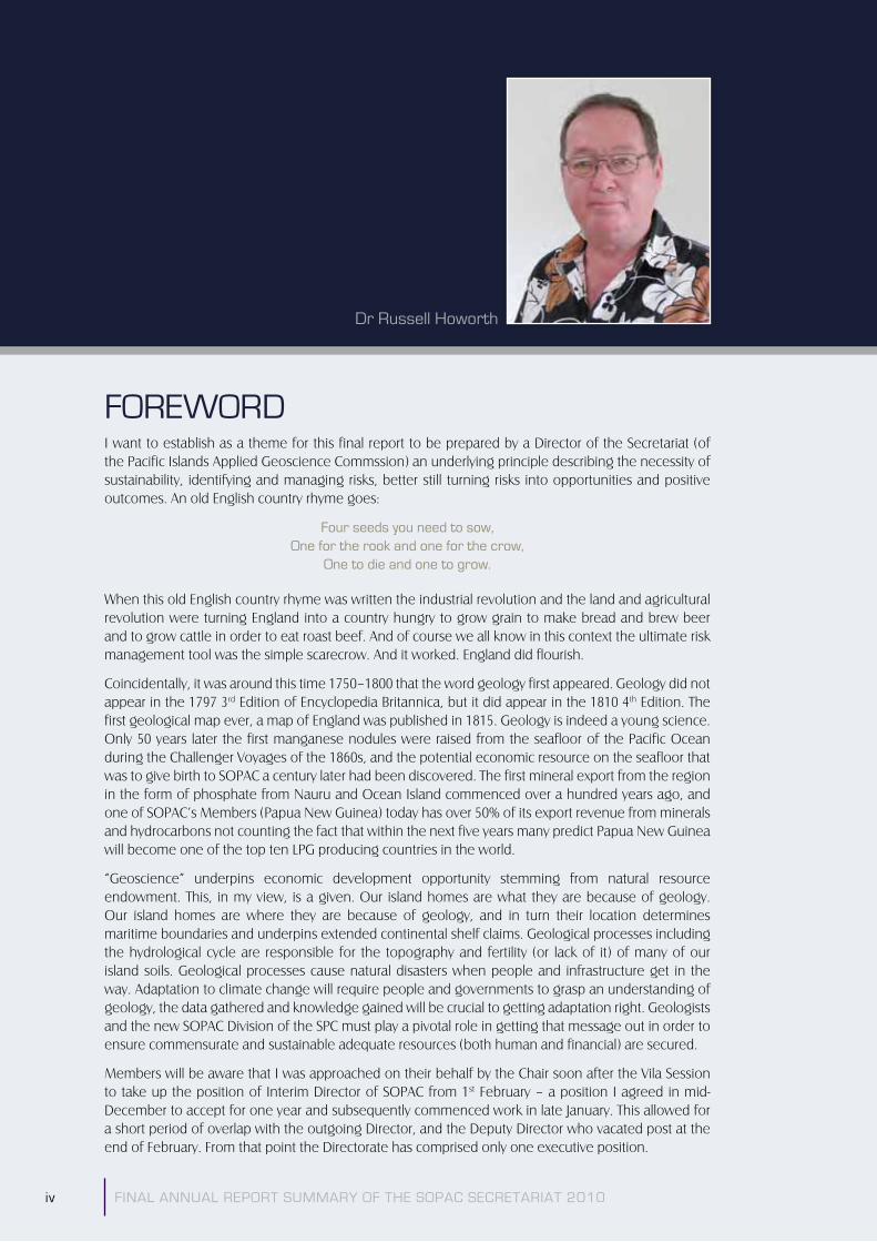
Dr Russell Howorth
FOREWORD I want to establish as a theme for this final report to be prepared by a Director of the Secretariat (of the Pacific Islands Applied Geoscience Commssion) an underlying principle describing the necessity of sustainability, identifying and managing risks, better still turning risks into opportunities and positive outcomes. An old English country rhyme goes:
Four seeds you need to sow, One for the rook and one for the crow,
One to die and one to grow.
When this old English country rhyme was written the industrial revolution and the land and agricultural revolution were turning England into a country hungry to grow grain to make bread and brew beer and to grow cattle in order to eat roast beef. And of course we all know in this context the ultimate risk management tool was the simple scarecrow. And it worked. England did flourish.
Coincidentally, it was around this time 1750–1800 that the word geology first appeared. Geology did not appear in the 1797 3rd Edition of Encyclopedia Britannica, but it did appear in the 1810 4th Edition. The first geological map ever, a map of England was published in 1815. Geology is indeed a young science. Only 50 years later the first manganese nodules were raised from the seafloor of the Pacific Ocean during the Challenger Voyages of the 1860s, and the potential economic resource on the seafloor that was to give birth to SOPAC a century later had been discovered. The first mineral export from the region in the form of phosphate from Nauru and Ocean Island commenced over a hundred years ago, and one of SOPAC’s Members (Papua New Guinea) today has over 50% of its export revenue from minerals and hydrocarbons not counting the fact that within the next five years many predict Papua New Guinea will become one of the top ten LPG producing countries in the world.
“Geoscience” underpins economic development opportunity stemming from natural resource endowment. This, in my view, is a given. Our island homes are what they are because of geology. Our island homes are where they are because of geology, and in turn their location determines maritime boundaries and underpins extended continental shelf claims. Geological processes including the hydrological cycle are responsible for the topography and fertility (or lack of it) of many of our island soils. Geological processes cause natural disasters when people and infrastructure get in the way. Adaptation to climate change will require people and governments to grasp an understanding of geology, the data gathered and knowledge gained will be crucial to getting adaptation right. Geologists and the new SOPAC Division of the SPC must play a pivotal role in getting that message out in order to ensure commensurate and sustainable adequate resources (both human and financial) are secured.
Members will be aware that I was approached on their behalf by the Chair soon after the Vila Session to take up the position of Interim Director of SOPAC from 1st February – a position I agreed in mid-December to accept for one year and subsequently commenced work in late January. This allowed for a short period of overlap with the outgoing Director, and the Deputy Director who vacated post at the end of February. From that point the Directorate has comprised only one executive position.
FINAL ANNUAL REPORT SUMMARY OF THE SOPAC SECRETARIAT 2010iv

Under these circumstances and in order for staff to remain focused on their principal tasks the Executive Management Team was expanded, but at the same time kept its meetings to a minimum. A Strategic Planning Team was also established comprising a diverse group of staff to prepare the new strategic plan. Other small teams were established as necessary to deal with specific matters such as: (i) improving media and communications including the website; (ii) facilitating access to SOPAC databases for the benefit of Members and the public at large; and (iii) completing a review of the Secretariat ICT policy, to name but three.
I must stress that the Secretariat, in particular the staff, have been under enormous pressure. It is true that many have had very difficult circumstances to cope with, especially those knowing that their positions were not secure as a result of budgetary uncertainties. Staff livelihoods have been at risk and staff morale severely impacted: and yet service delivery has been maintained at a very credible level. The reporting under the work programmes will attest to this. There also continued to be many requests for additional work that came from Members. I think I am correct in stating that none of these were declined, at worst implementation had to be delayed.
The staff surely deserve all the commendation Members can afford to offer. I myself wish to put on record my gratitude to them. In recognition of their support the staff were invited to be part of the final Commission Annual Session in Nadi, Fiji, in October, to see and witness first hand the difference between the Commission and its Secretariat, as well as participate in the STAR Meeting. Most staff had never experienced the Commission at work through its Council meetings and the final opportunity was not to be missed when the host Government, Australia, chose to hold the last SOPAC Council meeting in Nadi. The Secretariat staff is very young in two ways. First, when I returned to the Secretariat in February this year after retiring in September of 2005, over 80% of the staff were new to me. In other words they had joined the Secretariat during the past four years; and second, the average age was 32 years.
Last year (2009) I was privileged to have been invited by the Chair of STAR, Professor John Collen of Victoria University of Wellington to write and present a history of SOPAC at the Vila Session.
The paper entitled “The Metamorphism of SOPAC” traced the history of SOPAC over nearly four decades from 1972 to 2009. As the reference to the geological term metamorphism in the title alluded, it has been a history of change of form of SOPAC without so much a change in overall substance or purpose. It was established as a geoscientific and geotechnical organisation to assist its Pacific island Member states. SOPAC has remained so throughout, but for sure within an evolving broader context of the role of the earth sciences in sustainable development of its Pacific island Members.
I began that history with the following quote from Winston Churchill (November 1936):
“Owing to past neglect, in the face of the plainest warnings, we have entered upon a period of danger…. The era of procrastination, of half measures, of soothing and baffling expedience of delays,
is coming to its close. In its place we are entering a period of consequences”.
I concluded with the following quote from: Shakespeare, As You Like It, Act 2 Scene 1 –
“Sweet are the uses of adversity, Which, like the toad, ugly and venomous, Wears yet a precious jewel in his head…”
As we progress with crossing the bridge from SOPAC “The Commission” to SOPAC “The Applied Geoscience and Technology Division” of the SPC, we are indeed “entering a period of consequences”. Most importantly, now is the opportunity to grasp that “precious jewel”.
As noted in the Preface, this final annual report of Commission business will deviate from previous annual reports for the purpose of ensuring a good record of the conclusion of the Regional Institutional Framework (RIF) matter pertaining to SOPAC “the Commission” is available in the public domain. My contribution to this report therefore is by necessity lengthier than this Foreword; it runs into the next section on the Suspension of SOPAC “the Commission”; and then a third and final section on highlights from 2010 work programme implementation.
I am deeply honoured to have been sought out by SOPAC Members to ensure the orderly transition into the most significant metamorphism of SOPAC’s form to date.
FINAL ANNUAL REPORT SUMMARY OF THE SOPAC SECRETARIAT 2010 v

FINAL ANNUAL REPORT SUMMARY OF THE SOPAC SECRETARIAT 2010vi
THE SUSPENSION OF SOPAC “THE COMMISSION” & THE CONCLUSION OF THE RIF PROCESSES PERTAINING TO SOPACThe Regional Institutional Framework (RIF) Reform Process
The singular most important matter that has dominated the past few years was of course the RIF reform process. The uncertainties surrounding this matter started some three years ago in 2007 but the outcome of the Vila Session a year ago served only to compound the uncertainties.
The challenge was to turn the uncertainty into opportunity and do it in a timely fashion.
Members needed reassurance that by the time of the final annual meeting in Nadi most of these uncertainties had been significantly addressed and it has in my view generated a more stable and reinvigorated Secretariat.
Nevertheless, it is necessary for the record to recap on what was progressed regarding implementation of the RIF as it was the predominant aspect of the life of the Secretariat during the 2009–2010 reporting period.
Immediately upon taking up office, on February 1st I articulated the uncertainties as I saw then in an email to the Chair. The rest as they say is “history”. The way forward has not been and easy one. As for my own performance, not all Members I am aware have been satisfied all of the time, but I hope my role as CEO has been transparent, open, and above all else frank. I can only apologise to Members for any perceived shortcomings.
It is important to put on record that there were a number of positive issues that were key to achieving the progress made over the remaining months of 2010. These issues include but are not restricted to the following: the strong support and leadership from Vanuatu Minister Telukluk as Council Chair; many Member representatives who individually offered their support as a “sounding board” for myself; strong support from my CROP colleagues in particular the Secretary-General of the Pacific Islands Forum Secretariat, Neroni Slade, Director of SPREP, David Sheppard, and of course the Director-General of the SPC, Jimmie Rogers; and a communications strategy with Members that was regular though at times somewhat informal through email. At the same time all the staff of the Secretariat were kept abreast of progress through regular staff meetings and email updates.
For their records, SOPAC Members were provided with a final and formal record of the Letters of Agreement in a bound compendium at the final SOPAC Governing Council meeting in October, which is also available electronically on the CD appended to this document (Appendix 5).
For this record, I highlight the following key milestones that need to be recognised:
�� ��������th Two-Track process agreed with my colleagues at SPREP and SPC
�� �������� rd Two-Track process endorsed by Council Subcommittee
�� ����� �st First three LOAs signed
�� ��������st A staged process with milestones agreed by Members for developing and considering the LOA for the core programme
�� ������th First Draft of LOA approved (majority of full Members supported) and signed by Director-General of SPC and myself
�� ������th Final Draft of LOA was able to be circulated following no negative response and minimal suggestions for change
�� ��������nd Responses enabled an “Out of Session” consensus decision and Chair approved the signing of the LOA
��
��
���
����
��������
�����
��

FINAL ANNUAL REPORT SUMMARY OF THE SOPAC SECRETARIAT 2010 vii
�� ��������th Final LOA signed in Leaders’ Plenary at the Forum in Vila
�� ����������th Members updated on progress with implementation prior to October Governing Council Meeting
�� ������st SOPAC the Applied Geoscience and Technology Division of SPC begins operation
The signing in August brought the RIF reform process to a close with respect to the Leaders’ wishes regarding SOPAC. The final, and fourth Letter of Agreement to complete the transfer and integrate the work programme of SOPAC into SPREP and SPC had been accomplished. A major achievement was the retention of the core programme of SOPAC as a whole and that it would transit into SPC to become the new Applied Geoscience and Technology Division to commence operations on 1 January 2011.
Many I know think the name of the division should refer to science and not geoscience. I invite you to consider the uniqueness that SOPAC science brings to the table to underpin opportunity for economic development for SOPAC island Members. I have already alluded to this at the beginning of this Report. It is my strong view that it is indeed SOPAC’s excellence in geoscience that will immediately (not ultimately) distinguish this new division from the excellent science already done in other divisions of SPC.
The RIF road pertaining to SOPAC has now led to a bridge with SOPAC “the Commission” poised to cross that bridge to become SOPAC “the Division” of the SPC. Crossing that bridge will itself take time and clear guidance is needed for Members during this period. That guidance is provided in the 2011–2015 Strategic Plan which was among the final items approved by the SOPAC Governing Council along with the suspension of the Commission at its final meeting in Nadi, in October. The plan was prepared during the six months prior to the Nadi meeting through a consultative process which enabled Members to have draft copy in capitals and circulation to the STAR Network and other stakeholders by the end of July and feedback to the Secretariat by the end of August.
To ensure the bridge does not collapse as we cross it, a series of joint SOPAC/SPC working groups comprising what has been christened “the Domino Team” were established in administration, finance, HR, IT and corporate overview. These groups began their work in earnest around May with a very tight deadline to get the dominoes all lined up and ready to fall in place, in order to ensure the bridge did not collapse on 1 January 2011.
Before leaving the RIF and SOPAC’s response it, I must make two final observations:
Firstly, the SOPAC staff have had, in parallel with the RIF reform process, to cope with preparing for the impact of the institutional move; and to implement the outcomes of the CROP new harmonisation of remuneration arrangements. This included preparation of new job descriptions and job evaluations for all positions. New performance assessment procedures were introduced as well in the move to a remuneration system that clearly separates “pay for the job” from “pay for the person” and ensures ultimately that staff are “paid for performance”. These began implementation on 1 January 2011 within SPC. There were 100 staff to deal with as well as transfer them into SPC contracts. This was not easy and the road at times bumpy.
Secondly, is that there is no completion on 1 January 2011. If the signing of the LOA on August 4th marked the end of the RIF for the Leaders; in reality it was the “end of the beginning” for SOPAC and SPC. January 1st in turn may well mark the “beginning of the end” – for into 2011 final and formal details will need to be transacted for SOPAC “the Commission”, to comply with its financial and contractual obligations as a legal entity.
��
��
��

FINAL ANNUAL REPORT SUMMARY OF THE SOPAC SECRETARIAT 2010viii
In preparation for this, the SOPAC Governing Council at its final meeting (Nadi, October 2010), having fully considered the issues within the context of the Agreement Establishing SOPAC agreed that:
i. SOPAC “the Commission” be suspended on or before 30th September 2011 once the audited accounts for the necessary part of 2011 are received and approved by the troika of past Chair [Vanuatu], current Chair [Australia] and current Vice Chair [Cook Islands], acting on behalf of Council.
ii. Suspension does not preclude any Member of the Commission from withdrawing from the Commission should they desire, requiring only that Fiji, as depository of the instruments of ratification, be notified.
iii. Any Member or Members who at any stage feel the desire to resurrect the Commission, should write to the Troika giving their reasons and seeking the support of Members. The Troika will coordinate Members’ responses to the proposal to resurrect. The Commission will be resurrected if Members of the Commission agree by consensus. If consensus cannot be achieved, agreement of at least two-thirds of the full membership will be required.
iv. That [the SOPAC 39th Session held in Nadi, Fiji, in October 2010] was the last meeting of Governing Council.
The Governing Council delegated its authority to oversee the process agreed for the suspension of the Commission and the orderly closure of its financial books, to the Director-General of SPC in concert with the Troika; and extended my contract into 2011 reporting to the Director-General until such a time that he completed the formal recruitment process for the first director of the new Applied Geoscience and Technology Division.

FINAL ANNUAL REPORT SUMMARY OF THE SOPAC SECRETARIAT 2010 ix
HIGHLIGHTS FROM WORK PROGRAMME IMPLEMENTATIONWork Programme Delivery Highlights
RIF nothwithstanding, the SOPAC work programmes continued to be delivered and managed; and given the expiry of the last SOPAC planning document (Strategic Plan 2005–2009), a new strategic document for the transition period of the first few years of the integration of the Commission’s work programmes into SPC urgently needed to be formulated.
I have already stated that the Secretariat has maintained a credible level of work programme delivery throughout the year; as attested to by the full reports in the Work Programme Reports 2010 section of this annual report.
Nevertheless, Programme Managers provided what they consider to be a few key highlights from their programmes and I have selected three from each. Here they are and may I stress they are in no particular order. They are my choice, and are selected to illustrate the range and scope of the work. As Members you may judge for yourselves the direct national impact to your own country and how SOPAC’s regional efforts have supplemented and/or provided for your national needs. I also invite the representatives of active donors and/or partners to ascribe importance according to your contributions to making the highlights possible.
The highlights are listed in truncated titles below; but are embedded within the 2010 Work Programme Reports section of this annual report:
From the Ocean and Islands Programme:
�� ��������!��!�"�����������#
�� $���������"��"������&�������������'����������"������*�+����<�=������#
�� �����!��>���"�������������������?��������"���!����#
From the Disaster Reduction Programme:
�� Q�?����!���� �&� � '����� Q������� X��\� ����!���� �"� ^��!��� ^����� �"������� _������Action Plan for Tonga.
�� _�*� "������� ���\� !���!���� ��?������� �����!����� ������ "�?�����"� &��� =������� �"�Tuvalu.
�� Q�?����!�����&�������������\��`�������"�����&�����?��������"���!����#
And from the Water and Sanitation Programme:
�� ^�!!�����������&�����X�*�X�?���&���"�&�����������"�*����������!������'�#
�� ^�!���������&����!��������?�������"*����*�������?��&���_���#
�� z!���!���������&�*����"�!�"�!���!�������_����"�!���������������&�������"����������water losses.
In addition, within the work programmes several partnership networks established by SOPAC have continued to operate and have developed and strengthened over the year. These include:
�� ����{��&���{����������z������?�����$���������|��������!���}
�� ����{��&���Q�������X��\�����!����{����������_��*��\}
�� ����{��&���X�������<�~�?����!������"�~����!����_��*��\}��"
�� �z$�{�_��#
��
��
��
���
��������
��������
���
��
��
���
��
��
�

FINAL ANNUAL REPORT SUMMARY OF THE SOPAC SECRETARIAT 2010x
Looking to the future, Member are invited to recognise and support the recent Forum Leaders’ decision (Vila Forum Communiqué) regarding the urgency to:
�� &�����������"�����������&����!�����!����!������"����}
�� �����������������������?������&��&��"���\����*�����"������������������?����}��"
�� �`��"�����"�&���������&�"����������\�!���!��������"���������"������!���������������people focused, covering responses to health disasters as well as factoring in population growth and movement.
Whilst these issues are covered in the Pacific Plan priorities, the Leaders have stated that the issues require much more effort and necessary dedicated resources. This is highlighted in the Strategic Plan 2011–2015 for the new SOPAC Division of the SPC. Furthermore, as described in the plan this increased effort requires the input of SOPAC science and technology, GIS and Remote Sensing and natural resource economics.
SOPAC Work Programme and Climate Change Adaptation
SOPAC Members should remain deeply concerned that good science and technical data are collected and made available in order to better inform decision making. This is particularly important in the environmental vulnerability context where we must understand “normal” or historic natural change. Thereby with ongoing monitoring, island communities at all levels will be better able to build coping strategies that will build resilience and adapt to the increasing vulnerability the islands are facing – not the least of which is from the adverse impacts of climate change.
As well as SOPAC’s direct scientific work in relation to adaptation to climate change, much of its economics work has a bearing on climate change analyses because of the extent to which it can be used to inform adaptation. For example, the joint SOPAC and SPC work on vegetation mapping and monitoring, and SOPAC’s economic assessments of flood mitigation options including early warning systems, improved forecasting systems and raising the height of houses to accommodate floods. All of these strategies can be used to adapt to increased intensity and/or frequency in extreme weather events.
One of the most significant challenges facing SOPAC, and other regional and global partners is the need to integrate our efforts in assisting Members to mainstream disaster risk management and climate change adaptation considerations into the national planning and budgetary processes. There is an overwhelming convergence on this at a philosophical level and over the last two years or more both regional and global fora have made commitments towards an integrated approach. What we have not seen to a significant extent are the practical applications of the philosophy. Therein remains a challenge for the region in the context of climate change adaptation financing.
The Science Technology and Resources Network (STAR)
The theme for the STAR Meeting 2010 was Pacific Geoscience: Towards 2020 in the Face of Dwindling Global Natural Resources. It attracted some fifty-plus papers and a special session entitled Map Once Use Many Ways was convened with the Circum Pacific Council, formerly the Circum-Pacific Council for Energy and Minerals. The latter marks the rekindling of a partnership that extends back some two decades to the days when SOPAC was the UNESCAP protégé called CCOP/SOPAC.
For over twenty-five years SOPAC Governing Council has nurtured the partnership with STAR, an independent body comprising some of the best national, regional and international scientists and technologists working on geoscience as it relates to development in the Pacific.
���
�����
���

Quite rightly the STAR network has been buzzing in the last couple of years with concern about the impacts of the RIF. I am pleased to be able to report that those concerns may now be becoming appreciated as possible opportunities for a better and stronger STAR in the future. I firmly believe that the partnership with the expanded SPC will be one that endures.
Finances
Let me now turn to the finances. With the exception of the arrears in Members’ contributions matter, the auditors gave the Commission an unqualified Management Letter for the Financial Statement for 2009.
On the matter of Members’ arrears in contribution, SOPAC Council “noting the suspension of the Commission” came to the extraordinary decision of forgiving the arrears for Guam and Nauru (prior to 2010). All other Members who hadn’t paid up 2010 contributions and had arrears from the previous year solemnly undertook to pay up any unforgiven arrears prior to the completion of the SOPAC audit in 2011 for the purpose of closing down final SOPAC accounts for complete integration with SPC.
It would be remiss of me not to once again highlight that the work programme has been operating throughout most of the year with an unbalanced budget. If it were not for the fact that the Commission had significant savings accumulated at the end of 2009, to balance the budget would have required retrenching some fourteen staff. These savings were identified in the 2009 Auditors Report, but they of course are not identified in the 2010 Budget, because of the accrual accounting procedures used by the SOPAC Secretariat.
The negative impact of the unbalanced budget on work programme delivery would in my opinion have been nothing short of a major disaster. Thus a singular focus of my efforts during the year has been to avoid this disaster materializing. Fortunately I was able to utilise the savings together with implementing austerity measures in the day-to-day operations of the Secretariat.
I am pleased to report a balanced budget for 2010 totalling close to F$16 million together with a balanced budget for 2011 totalling close to F$19.5 million plus an additional F$14.5 country-dedicated funds. All staff positions and a substantial work programme are secured to the end of 2011.
I am also pleased to report on three of several new partnerships/projects that have come online. New initiatives with UNESCO through its Apia Office; and the Word Bank through its Sydney Office support staff positions in the Disaster Reduction Programme location in Suva. One large project with the EU on deep sea minerals in the Ocean and Islands Programme, whilst delayed, has now commenced implementation with staff recruitment underway.
Towards a Sustainable Budget
The transfer and integration into the SPC provides no better opportunity to review the way the budget is structured and funded. I have already alluded to the principle of necessity of sustainability and long-term sustainability of funding being key. A budget that historically has derived some 90% of its funding from essentially project-based sources is clearly far from sustainable, often volatile, and time consuming on staff time to address. On the other hand Members’ ability to pay through increased membership contributions is not the solution particularly at this time with national economies and budgets under stress due to the global financial crisis. At this point I would like to acknowledge the voluntary contributions received from Associate Members (of SOPAC) New Caledonia and French Polynesia.
Many of you will know SPC has embarked on a long-term sustainable financing exercise this year. I suspect the very nature of the exercise will require a good deal more time and thought than has been possible during 2010 to date and SOPAC “the Division” will get the opportunity to become fully engaged during 2011 and beyond. Innovative solutions are needed.
FINAL ANNUAL REPORT SUMMARY OF THE SOPAC SECRETARIAT 2010 xi

FINAL ANNUAL REPORT SUMMARY OF THE SOPAC SECRETARIAT 2010xii
Strategic Plan
In closing I would like briefly to return to the strategic planning exercise. In normal strategic planning there should be a high level of security of income (take for example a town council with a substantial part of its budget received through reasonably assured income from rates and what was expected to be delivered after three or five years in any strategic plan cycle).
For a regional organisation such as SOPAC or SPC it is simply not possible, practical or realistic to develop a strategic plan along such lines because of the inherent insecurity of the funding base (as described) beyond any one given year at a time. To address this SOPAC must develop a strong link between its Strategic Plan and its Annual Work Plan and Budget. It is in the latter that key deliverables (outputs) can be set and success or otherwise quantified. The link between these two documents and their operative processes must be a robust monitoring and evaluation procedure that is able to build upon the annual quantifiable results in order to demonstrate key result area outcomes of the strategic plan are achieved over the longer time frame. The 2011–2015 Strategic Plan does this.
It is not practical, or realistic, for statements such as x tasks delivered in y countries over five years to appear in a strategic plan for SOPAC whilst the budget continues to be derived the way it currently is. The reporting presented to the Council meeting in Vila on the last 2005–2009 strategic plan clearly demonstrated this.
I return again to the underlying principle describing the necessity of sustainability, identifying and managing risks, better still turning risks into opportunities and delivering on realistic positive outcomes.
To achieve all of what needs to be accomplished I want to conclude with a plea to Members that it is crucial the SOPAC work programme in its new home retains the full support of all SOPAC “the Commission” Members, the new Members under the SPC umbrella and partners. The SOPAC work programme was built up over nearly four decades into a very credible and internationally recognised vehicle to deliver geoscience and technology advice to its island Members. In its new home, along with the existing work programmes of SPC, they all collectively have the opportunity to become a “precious jewel”.
Again, my plea to Members is that “this precious jewel” must not be lost sight of.
Russell Howorth SOPAC Director
Russell Howorth

FINAL ANNUAL REPORT SUMMARY OF THE SOPAC SECRETARIAT 2010 1
WORK PROGRAMMEREPORT 2010

FINAL ANNUAL REPORT SUMMARY OF THE SOPAC SECRETARIAT 20102
The 2010 progress reports that make up the bulk of this document are drawn from the technical work programme reports tabled before the SOPAC Governing Council at its final meeting in October 2010. Implementation of the RIF began with the transfer of some of the functions of SOPAC under the Community Lifelines Programme into SPC and SPREP in March 2010, the bulk of the reporting to Council in 2010 was undertaken under the new technical programme names adopted for the new SPC Applied Geoscience and Technology Division (SOPAC) Strategic Plan (2011–2015), that would guide work programme considerations within the SPC from January 2011.
The names of the three technical programmes are Ocean and Islands (no change); Water and Sanitation (formerly Community Lifelines); and Disaster Reduction (formerly Community Risk).
Technical support services that cross cut the work of the three technical work programmes are: natural resource economics; GIS and remote sensing; technical equipment and services; data management; and publications and library. Technical equipment and services is managed under the Ocean and Islands Programme and the bulk of its activities are reported under that programme. Activities by these technical support services not covered in programme reporting are reported in the concluding section of this part of the Annual Report 2010.

FINAL ANNUAL REPORT SUMMARY OF THE SOPAC SECRETARIAT 2010
Ocean & Islands Programme“The OIP has delivered all planned outputs for the year. The OIP team are positive [about] the merger with SPC and have already identified several areas within the SPC where they can engage and interact to supplement and enhance existing [] programmes. New areas of cooperation and collaboration [] include habitat mapping, fisheries research, maritime industry support, expansion of climate change research and deep sea mining.”(OIP PMEG 2010)
3

FINAL ANNUAL REPORT SUMMARY OF THE SOPAC SECRETARIAT 20104
ocean & islandsprogramme
This 2010 Ocean and Islands Programme (OIP) report is organised under six functional areas:
1. MARINE, COASTAL SCIENCE AND SURVEY
2. GEOLOGY, MINERALS AND HYDROCARBONS
3. SOUTH PACIFIC SEA LEVEL AND CLIMATE MONITORING PROJECT
4. REGIONAL MARITIME BOUNDARIES
5. DATA AND INFORMATION MANAGEMENT
6. TECHNICAL WORKSHOP
Previously, the Natural Resource Economics (NRE) sector and the PI GOOS (Pacific Islands Global Ocean Observation System) mandate were managed in OIP. Under the new 2011–2015 strategic plan NRE has become a cross programme support service and the PI GOOS mandate was transferred to SPREP in March 2010.
1. MARINE, COASTAL SCIENCE AND SURVEY
Often seen as the “traditional core” of OIP this is the largest sector of the programme with seven staff working in the areas of: oceanography; hydrography; coastal processes and geomorphology; geophysics; hydrodynamic modelling; habitat mapping; and geodesy and cartography. It is also important to note that the greater volume of the Technical Workshop (functional area 6) tasks are oriented towards support and facilitation of this sector’s work, given its heavy dependence on fieldwork, use of technical equipment and substantive requirements for specialist logistical and mobilisation support.
The sector undertook eight field surveys during the reporting period and a number of routine site visits, assessments and reviews. These have been characteristically diverse in terms of the types of requests, locations of work and stakeholder groups and aims involved. The range has included requests by the local Fiji Electricity Authority (FEA) to survey the Monasavu hydroelectric dam in Viti Levu with our bathymetric mapping multibeam system. This was requested to ascertain possible sedimentation problems in the lake and given Monasavu provides a significant portion of Viti Levu’s electrical power supply this is an extremely important facility and accurate bathymetric study will provide an excellent baseline for ongoing monitoring. Related has been additional work for FEA to assess potential tidal energy available to generate clean, renewable power using submarine turbines driven by tidal currents.
Two major coastal surveys were completed including a six-month campaign undertaken in Funafuti, Tuvalu, to provide accurate baseline information to the Government of Tuvalu for their JICA-funded Funafuti coastal vulnerability project. This work included review of OIP’s historical data from Funafuti and its compilation into a single document and a range of field tasks implemented across the atoll from water quality sampling, wave and current measurement, bathymetric mapping and detailed topographic survey across all islands on Funafuti. The topographic dataset represents one of the most comprehensive and accurate datasets of land height for an atoll island in the region and if combined with OIP’s earlier detailed bathymetric data

FINAL ANNUAL REPORT SUMMARY OF THE SOPAC SECRETARIAT 2010 5
ocean & islandsprogramme
has numerous potential applications in guiding development and assessing vulnerability and potential adaptation responses. Similarly, the Government of the Commonwealth of the Northern Mariana Islands requested OIP to undertake a comprehensive survey in Saipan’s lagoon and nearshore environments. The fieldwork has been completed and work on the development of a hydrodynamic model of the lagoon is ongoing. This will show main flow patterns and improve understanding of issues such as water quality, pollution and sediment transport.
Hydrodynamic modelling (HD modelling) refers to the use of powerful computers and specialist software to model waves and the movement of water in bodies such as lagoons and nearshore areas and can greatly improve understanding of water movement, water quality issues, sediment movement patterns, wave climate and impacts, among others. Given the predominantly coastal nature of Pacific Island Country (PIC) settlements and towns it is not surprising that HD modelling has become an indispensable component of the sector’s technical capacity. Demand for the modelling capacity across a range of issues continues to grow, particularly in its application to coastal vulnerability issues, such as tsunami modelling (see story on page 16).
Major HD modelling tasks in the reporting period, include work in Aitutaki Island, Cook Islands, which was started in 2007 under the EDF Reducing Vulnerability Project (this project ended in December 2008). This work has been ongoing and if significant benefits can be obtained, OIP seeks to continually value add and improve outputs for Members. The Aitutaki HD and Arutanga Channel circulation model was completed last year and recent work has concentrated on developing “weather scenarios”. A weather scenario means we can test changes on impacts to shoreline systems or infrastructure (in this case Arutanga Channel) under different wind/wave and design conditions. Likewise, the Saipan Lagoon HD modelling tasks will provide information on different wind/wave conditions and will also provide important information on the performance of an effluent outfall pipe. Other tasks have included use of the existing Tarawa Lagoon HD model to test the possible benefits/impacts of opening causeways or building new passages in the Temaiku area of South Tarawa, Kiribati to improve lagoon water quality.
This sector also provided expert advice and review on Environmental Impact Assessment (EIA) and development applications. It is important to note there is ever increasing demand being placed on this sector and its capacity and tools, particularly from the perspective of the assessment of coastal vulnerability, coastal infrastructure and coastal climate change adaptation. SOPAC has long understood that vulnerability and adaptation and development in coastal zones must be underpinned by sound, pragmatic assessment and design of response measures must be based on empirical assessment and be appropriate to needs. All too often well meaning, but poorly conceived and resourced efforts to implement works under the banner of “adaptation and vulnerability reduction” can result in more environmental damage than good and “mal-adaptation”. This important role to support coastal vulnerability, adaptation and development issues at a regional level; and provide adequate “technical backstopping” to other projects and initiatives, can only be a reality if OIP is adequately resourced. Recent assessments include assistance to the Department of Environment, Fiji, to assess inundation issues in Daku Village, Viti Levu; assistance and a rapid assessment of four coastal adaptation projects in Samoa, implemented by the UNDP GEF Small Grants Programme; expert review of water quality issues and reclamation in South Tarawa, Kiribati; technical assistance to the Government of the Federated States of Micronesia to assess dredge spoil dumping options; team review of the Tuvalu outer islands boat channel upgrade project; and expert technical input on the development of the Nadi Bay, Fiji, flooding and inundation vulnerability proposal.

FINAL ANNUAL REPORT SUMMARY OF THE SOPAC SECRETARIAT 20106
2. GEOLOGY, MINERALS AND HYDROCARBONS
The functional area of “Geology, Minerals and Hydrocarbons” covers terrestrial and deep sea resources, geology, aggregate resources and assessment, resource database development and resource management and policy support.
Activities during 2009/2010 focused on the continued rescuing and transcribing of historical data holdings such as the Petroleum Database and updating our internal holdings of regional information on deep sea mineral resources. OIP is tasked to report the number of enquires against the Petroleum Database every year and fifteen requests were received during the reporting period. The sector continues to provide support in the area of construction aggregate supply and this work is often inextricably linked to the Marine, Coastal Science and Survey Sector as well as the NRE sector. This dynamic emerges because of the prevalence of beach mining in the region and the need for technically and environmentally appropriate solutions to beach mining which are also socially and economically viable. Frequently these issues are most urgent in the urban atoll centres such as Majuro, Tarawa and Funafuti and OIP integrates across various sectors to deliver effective solutions; such as the EU Envelope C Project Environmentally Sustainable Aggregates for Tarawa (ESAT – this Project is highlighted in the story on page 17 of this report).
Last year OIP reported that its much anticipated European Union EDF10 Deep Sea Minerals in the Pacific Islands Region: a Legal and Fiscal Framework for Sustainable Resource Management Project proposal had been successful and that funding was expected to be released in the last quarter of 2009 and thus recruitment and project work should be well underway in 2010. The €4.7million project had stalled due to reasons beyond OIP’s control and the EU Contribution Agreement was only recently signed in August 2010. Funding become available in the last quarter of 2010 and recruitment of three key positions in the Project were undertaken. Despite the unfortunate delay OIP worked hard to maintain partner and country interest and confidence in this activity and good engagement with Members on this important activity was expected. Otherwise, in-house efforts to collate data and information on regional deep sea mineral resources have resulted in the production of six information brochures which combine information on regional and country-specific deep sea mineral resource occurrences and economic potential. The OIP Minerals Geologist has also supported a number of stakeholder requests regionally and internationally for support, presentations and advice on all aspects of the industry in the Pacific Islands region.
The sector also maintains its technical capacity and support to Members in terrestrial mining and has during this reporting period supported the Government of Solomon Islands in the development of the Isabel Nickel Mine tender and continued to support this process through ongoing technical input and review. Likewise, OIP was requested by the Government of Fiji to develop an indicative marine survey plan related to hydrocarbon resources. Other related work of economic importance has been the sustained efforts to assist the Government of Kiribati in a re-evaluation of the residual phosphate resource on Banaba Island. SOPAC mobilised it’s drilling team and equipment to Banaba in late 2008 and successfully completed drilling and sampling to provide improved data and information on volume and quality of the resource. Physical analysis of the samples was completed collaboratively with Kiribati Minerals Unit staff in 2009; and during 2010, chemical analysis was completed in collaboration with Victoria University – Wellington, New Zealand. These results have been interpreted and a comprehensive report which reviews past work and incorporates the most recent survey results compiled for the Government of Kiribati.
ocean & islandsprogramme

FINAL ANNUAL REPORT SUMMARY OF THE SOPAC SECRETARIAT 2010 7
3. SOUTH PACIFIC SEA LEVEL AND CLIMATE MONITORING PROJECT
The South Pacific Sea Level and Climate Monitoring Project (SPSLCMP) is AusAID-funded and has been ongoing since 1991. It initiated the establishment of the SEAFRAME array (Sea Level Fine Resolution Acoustic Measuring Equipment) or sea-level monitoring stations in Cook Islands, Federated States of Micronesia, Fiji, Kiribati, Marshall Islands, Nauru, Papua New Guinea, Samoa, Solomon Islands, Tonga, Tuvalu and Vanuatu. The funding for Phase 4 will finish at the end of 2010 and AusAID has confirmed a further five-year commitment to Phase 5, starting in January 2011. The Project is managed by the Bureau of Meteorology, Australia (BoMET) and implemented via a partnership between the National Tidal Facility of BoMET; Geoscience Australia (GA); and OIP.
OIP’s role includes the following:
i. The ongoing provision of routine and non-routine maintenance and calibration of the gauges, which include the sea-level gauge and a number of additional sensors (wind speed and direction, temperature, barometric pressure), the associated CGPS (continuous global positioning system) stations (these monitor slight ground movement trends which could have implications to rates of relative sea-level change) and the associated data transmission/communications equipment. This support is provided through the OIP Technical Workshop.
ii. Collaborative work undertaken with GA and the OIP Survey Officer to complete precision levelling surveys at each gauge site. This is carried out routinely to ensure that the station platform (in many cases located on the main wharf structure) is not moving relative to the CGPS station. For example, wharves are often perching on pile-driven posts, these can settle and move over time and this in turn could impact the recording of relative rate of sea-level change. During the reporting period surveys were completed at the following locations: Vanuatu (September 2009), Cook Islands (December 2009), Fiji (February 2010), Tonga (April 2010), Samoa (May 2010), Nauru (July 10), Tuvalu (August 2010) and Kiribati (September 2010).
iii. The regional coordination and communication component of the project is implemented via the OIP-based Communications Coordinator. This position is tasked with handling routine communications with Member country focal points, ensuring communications accounts are paid and in order, coordinates SOPAC involvement in the SPSLCMP Technical Coordination Committee (TCC) and has oversight of the development and implementation of regional communications and outreach products related to SPSLCMP. Most recently a communications strategy was developed and will be funded and implemented under Phase 5.
iv. OIP also acts in an advocacy role for the SPSLCMP at both regional and international fora, a recent example being discussions on “south-south” cooperative links with the CARICOM sea-level measuring array in the Caribbean and sharing knowledge and experiences. Additionally, OIP through the Marine, Coastal Science and Survey Sector is a major user of the SPSLCMP array both as a source of local sea-level data; as well as climate (especially wind) data. The array has also had an extremely important side benefit for OIP’s geodetic and survey work which crosses issues from maritime boundaries development through to coastal and nearshore surveys. The SEAFRAME stations and associated CGPS stations provided an extremely accurate geodetic datum point with a known relationship to mean sea level. Obviously, for any type of sea-level vulnerability study these are fundamental baselines and it is rather paradoxical that such information is still extremely rare in many PIC locations given the vulnerability of PIC communities to sea-level rise and wave climate extremes.
The anticipated array upgrade “ONUP” (Operational Network Upgrade Project) was approved for funding by AusAID and commenced this year with the appointment of a Project Manager and the development of logistical arrangements. At the time of reporting it was unclear what the precise role of OIP in ONUP may be, but the main implementing agencies of the upgrade work will be BoMET and GA. The upgrade is expected to improve accuracy, the life of the existing array instrumentation and improve the automated data sending capacity and systems to facilitate remote real-time data access. Related are the additional benefits this new capability will bring to the detection of tsunami and the improved integration of the SEAFRAME array into the regional early warning system.
ocean & islandsprogramme

FINAL ANNUAL REPORT SUMMARY OF THE SOPAC SECRETARIAT 20108
4. REGIONAL MARITIME BOUNDARIES
4.1 Exclusive Economic Zones (EEZ) development
The Regional Maritime Boundaries sector has been part of OIP since 2001 when the project was transferred to SOPAC from the Forum Fisheries Agency (FFA). Subsequent work under this sector had been mainly concerned with the development of Member EEZ baselines, zones and outer limits in accordance with the provisions of the UN Convention on the Law of the Sea (UNCLOS). The EEZ development work for PICs started from first principles in 2001, since no complete dataset was provided to SOPAC at the time of the transfer and FFA data could not therefore be used for boundary declaration purposes. By 2006 the countries of Cook Islands, Nauru, Niue and Tuvalu had received complete data reports from OIP which are suitable for verification and declaration purposes in accordance with UNCLOS requirements; however, by 2010 only one of these countries, Nauru, had used this information to declare its maritime zones. At the time of writing this report only Fiji, Nauru and Palau had declared their maritime baselines, zones and outer limits in accordance with UNCLOS and Papua New Guinea, Solomon Islands and Vanuatu have declared only their archipelagic baselines. Of these countries, four (Fiji, Palau, Solomon Islands and Papua New Guinea) are in the process of verifying/updating the data used (pre 2001) to declare their respective baselines and maritime zones with the assistance of the OIP Regional Maritime Boundaries sector.
The Maritime Boundaries sector also assisted Fiji, Kiribati, Palau, Papua New Guinea, Solomon Islands and Vanuatu develop their maritime boundary solutions. In many cases this is an ongoing commitment where work is sustained over several years; and in other cases such as Kiribati their maritime boundaries work started only recently in 2010 with field surveys to establish baseline positions. The 2010 status of Member country EEZ development is summarised below and it is important to acknowledge whilst considering this information that all PICs are signatories to UNCLOS and thus have specific obligations with regard to how they develop and declare their maritime zones, outer limits and shared boundary solutions.
�� ����������
o Maritime boundaries, baselines, zones and outer limits have not been declared in accordance with the provisions of UNCLOS and are not yet public.
o In receipt of a SOPAC data report providing solutions for baselines, zones and outer limits since 2005, which can be used for declaration purposes.
o Have established shared boundary treaties with French Polynesia (1990), American Samoa (1980) and Tokelau (2010). The shared boundaries with Kiribati and Niue are not yet negotiated.
o Current work revolves around the further verification of the SOPAC 2005 report.
o Cook Islands are encouraged to consider declaration of its maritime zones and high seas limits in accordance with UNCLOS.
�� ��������������������������
o Maritime boundaries, baselines, zones and outer limits have not been declared in accordance with UNCLOS and are not yet public.
ocean & islandsprogramme
���
����

FINAL ANNUAL REPORT SUMMARY OF THE SOPAC SECRETARIAT 2010 9
o The OIP has made several approaches to the Government of the Federated States of Micronesia to offer assistance, however, engagement at an official level has not taken place.
o Have established shared boundary treaties with Marshall Islands (2006) and Palau (2006). The shared boundary with Guam is not yet negotiated and it is presently unclear if the treaty with Papua New Guinea (1991) has been ratified.
o Federated States of Micronesia is encouraged to consider engaging with the SOPAC Regional Maritime Boundaries sector to assist them develop their boundary solutions.
�� ���������
o Maritime boundaries, baselines, zones and outer limits have been declared in accordance with UNCLOS and information is public (2007).
o Current work with OIP involves re-survey, processing, re-computing and update to maritime archipelagic baselines, zones and outer limits.
o Have established shared boundary treaties with Wallis and Futuna (1983) and Mathew and Hunter (1983). The shared boundaries with Tonga, Vanuatu, Solomon Islands and Tuvalu are not yet negotiated.
�� �������
o Maritime boundaries, baselines, zones and outer limits have not been declared in accordance with the provisions of UNCLOS and are not yet public.
o Have established a shared boundary treaty with French Polynesia. The shared boundaries with Nauru, Marshall Islands, Tuvalu, USA x 3 (Howland, Palmyra and Jarvis Islands), Tokelau and Cook Islands are not yet negotiated.
o Currently working with the Maritime Boundaries sector on baseline surveys and processing of the resultant data in the Northern Gilberts and Northern Line Group – work completed in 2010.
�� ����������
o Maritime boundaries, baselines, zones and outer limits have not been declared in accordance with UNCLOS and are not yet public.
o The OIP Maritime Boundaries sector has made several approaches to the Government of Marshall Islands to offer assistance however engagement at an official level has not taken place.
o Have established a shared boundary treaty with Federated States of Micronesia (2006). The shared boundaries with USA (Wake Island), Kiribati and Nauru are not yet negotiated.
o Marshall Islands is encouraged to consider engaging the Maritime Boundaries sector to assist them develop their boundary solutions.
ocean & islandsprogramme
����
���
�����

FINAL ANNUAL REPORT SUMMARY OF THE SOPAC SECRETARIAT 201010
�� ����
o Maritime boundaries, baselines, zones and outer limits have been declared in accordance with UNCLOS and information is public (1997).
o OIP provided verification report in 2005 to support shared boundary solutions.
o Have no established shared boundary treaties with either Marshall Islands or Kiribati at this time.
o Current work includes advising on shared boundary solutions in support of negotiations.
�� ����
o Maritime boundaries, baselines, zones and outer limits have not been declared in accordance with UNCLOS and are not yet public.
o In receipt of a SOPAC data report providing solutions for baselines, zones and outer limits since 2005, which can be used for declaration purposes.
o Have established a shared boundary treaty with American Samoa (1997). The shared boundaries with Cook Islands and Tonga are not yet negotiated.
o Niue is encouraged to consider declaration of its maritime zones and high seas limits in accordance with UNCLOS using the 2005 SOPAC data report.
�� ��
o Maritime boundaries, baselines, zones and outer limits have been declared in accordance with UNCLOS and information is public (2008).
o Have established shared boundary treaty with Federated States of Micronesia (2006). The shared boundaries with Indonesia and Philippines are not yet negotiated.
o Current work with OIP includes verification of baseline information and assistance to compute shared boundary solutions.
�� �������������
o Archipelagic baselines declared in accordance with UNCLOS and information is public (2002). High seas zones to the north and north east have not yet been declared.
o Current work with OIP involves re-survey, processing, re-computing and updating maritime archipelagic baselines, zones and outer limits. New archipelagic baseline report was delivered to Papua New Guinea in 2009; and work is underway on high seas solutions.
o All shared boundary treaties have been established with Indonesia (1980), Solomon Islands (1989); and Australia (1978); and Federated States of Micronesia (1991 – however the exact status of the treaty with Federated States of Micronesia is unconfirmed).
�� �!�
o Samoa has no high seas boundaries. Otherwise its maritime boundary baselines and inner zones have not been declared in accordance with UNCLOS and are not yet public.
o Has not established shared boundary treaties with any neighbour – Tokelau, American Samoa, Tonga or Wallis and Futuna.
o Samoa has its own arrangements for boundary development and does not participate in the Maritime Boundaries sector work; however, the sector can provide support if requested.
�� ���!��������
o Archipelagic baseline was declared in 1979. (OIP delivered an updated archipelagic baseline report in 2008). Other maritime boundaries, zones and outer limits have not been declared in accordance with UNCLOS at this time and are not yet public.
o Current work includes the development of the remaining maritime zones and outer limits and OIP will seek to progress this work during the November 2010 eCS workshop.
ocean & islandsprogramme
���
�����
�����
����
������
����

FINAL ANNUAL REPORT SUMMARY OF THE SOPAC SECRETARIAT 2010 11
o Have established shared boundary treaties with Papua New Guinea (1989); Australia (1988); and New Caledonia (1990). The shared boundaries with Vanuatu and Fiji are not yet negotiated.
o Solomon Islands is encouraged to consider declaration of its new updated archipelagic baseline in accordance with UNCLOS.
�� "��#
o Maritime boundaries, baselines, zones and outer limits have not been declared in accordance with UNCLOS and are not yet public.
o Has established a shared boundary treaty with Wallis and Futuna (1980). The shared boundaries with Fiji, Samoa, American Samoa and Niue are not yet negotiated.
o Tonga has its own arrangements for boundary development and does not participate in the SOPAC Maritime Boundaries sector work; but the sector can provide support if requested.
�� "�$�
o Maritime boundaries, baselines, zones and outer limits have not been declared in accordance with UNCLOS and are not yet public.
o In receipt of a SOPAC data report providing solutions for baselines, zones and outer limits since 2005, which can be used for declaration purposes.
o Has not established a shared boundary treaty with any neighbour – Fiji, Wallis and Futuna or Kiribati.
o Current work with OIP includes verification of critical base points to support shared boundary solutions.
o Tuvalu is encouraged to consider declaration of its maritime baselines, zones and high seas limits in accordance with UNCLOS using the 2005 SOPAC data report.
�� %����
o Archipelagic baseline was declared in 2010 in accordance with UNCLOS provisions and data is public (OIP delivered the archipelagic baseline report in 2009). Other maritime boundaries, zones and outer limits have not been declared and are not yet public.
o Has not established a shared boundary treaty with any neighbour – Fiji, New Caledonia or Solomon Islands.
o Vanuatu is encouraged to work with OIP to develop its remaining boundary solutions based on the new archipelagic baseline and declare these in accordance with UNCLOS.
To summarise: of these fourteen countries, three (Nauru, Palau and Fiji) have declared their baselines, maritime zones and high seas limits in accordance with UNCLOS and an additional three (Papua New Guinea, Solomon Islands and Vanuatu) have declared only their archipelagic baselines. Three countries (Cook Islands, Niue and Tuvalu) have had data reports developed by SOPAC in their possession for over five
ocean & islandsprogramme
���
���
�����

FINAL ANNUAL REPORT SUMMARY OF THE SOPAC SECRETARIAT 201012
years. These are adequate for declaration in accordance with UNCLOS but declaration has not occurred. Two countries (Samoa and Tonga) prefer their own arrangements for this work and SOPAC can not readily comment on status in these countries; and two additional countries (Marshall Islands and Federated States of Micronesia) have shown interest to engage with the SOPAC Regional Maritime Boundaries sector but have not so far invited our involvement at an official level. Of the remaining countries, Kiribati has recently engaged with the Boundaries sector and excellent progress on development of their baselines is underway. Solomon Islands and Vanuatu have both received assistance to verify their revised baseline data and recalculate their archipelagic baseline in the last two years, however continued development of their zone and outer limit computations have not yet been undertaken. Of the forty-eight shared boundaries which will require calculation of equidistant boundaries and negotiated treaties, less than half (21) are presently subject to treaty the most recent being signed between Cook Islands and Tokelau (OIP assisted in the development of baselines/verification for both countries).
Discussion of some of the challenges of pursuing declaration and a map showing those maritime boundaries which have so far been declared in accordance to UNCLOS are featured in the story on pages 18 and 19.
4.2 UNCLOS Article 76 or eCS development (extended continental shelf)
In 2006 OIP commissioned a desktop study by the National Oceanographic Centre UK to ascertain if PICs had potential to claim eCS (Extended Continental Shelf) territory beyond their 200 nautical mile EEZ limits (despite the fact that most PICs had not even declared the position of their respective 200 nautical mile EEZ). This desktop study defined potential in only four States and in the intervening three years between 2006 and 2009 OIP developed a consortium of technical partners (Geoscience Australia, UNEP GRID Shelf Programme, Commonwealth Secretariat, Japan Hydrographic Association, GeoCap and the University of New South Wales) who together undertook further analysis of existing regional data and by May 2009 the technical partners had assisted eight PICs (Cook Islands, Fiji, Federated States of Micronesia, Palau, Solomon Islands, Tonga and Vanuatu) to submit their respective, joint and SPLOS/183e (preliminary information) eCS claims to the UN Commission on the Limits of the Continental Shelf (UNCLCS). A further two countries (Tuvalu and Kiribati) are also developing eCS submissions which have a later deadline for deposition to UNCLCS in 2013.
In order for PICs to meet their respective deadlines (mostly by May 2009) some submissions were not 100% complete and require additional information and some submissions were also made under the provisions of SPLOS/183e (this is a UNCLOS provision which allowed countries to deliver preliminary eCS claim information rather than a full submission). The flexibility to submit eCS claims which will require additional work and SPLOS/183e preliminary information ensured that countries could meet their respective deadlines and that their intentions and approximate claim limits became publically available. Additionally it enables UNCLCS to review the claims and preliminary information and set a practical schedule for full technical review of each claim. Whilst the claims and preliminary information already submitted forms a substantive foundation for the completion of all PIC submissions, significant work remains to be completed. Thus eCS
ocean & islandsprogramme

FINAL ANNUAL REPORT SUMMARY OF THE SOPAC SECRETARIAT 2010 13
work in the Boundaries sector over the last year has been directly involved in continuing technical support to those countries’ claims and this has been predominantly delivered via the ongoing hands-on workshop series where country technical teams work on their respective submissions with the assistance of the technical resource group (OIP and its technical partners mentioned above). A further two-week intensive eCS development workshop was convened in February 2010 and a second two-week workshop was held in November 2010; making it the seventh such workshop and in total represents approximately 850 hours of face-to-face training and submission development provided by OIP and the core technical partners (Geoscience Australia, UNEP GRID Shelf Programme and Commonwealth Secretariat) to ten country teams (about 25 PIC nationals). Funding to resource these workshops has been sourced through three successful AusAID, PGSP (Pacific Governance Support Programme) and most recently PPSLP (Pacific Public Sector Support Linkage Programme) projects and the success of these proposals has in turn hinged on the close collaborative relationship and assistance of Geoscience Australia. In total, since 2007, AusAID has made some AU$1.34 million available to support PIC eCS work (including a special one-off grant to OIP in 2008).
It is important to reiterate that eCS submission is different to EEZ declaration. When a country declares its baselines, marine zones and outer limits it simply presents this information to UNCLOS in an established format and there is no subsequent technical review process by UNCLOS of this data, other than to ensure the provisions of UNCLOS were followed to derive these solutions. When PICs submitted their respective and joint eCS claims and SPLOS/183e documents they, in effect, acknowledged that they had an interest and substantive technical claim to eCS territory, however they also acknowledged especially in the case of SPLOS/183e that their claims were incomplete. All eCS claims will eventually be subject to technical review by a panel of experts under the UNCLCS and each country must complete their respective (and joint) claims before this technical review occurs. The countries must also have a dedicated technical and legal team to defend their claim(s) to the UNCLCS and each country will need to be capable of amending their claims if the UNCLCS requires (such as for eample changing a foot of slope point or providing additional supporting evidence. If these requirements are met and the UNCLOS is satisfied only then will PIC eCS submissions be granted.
The Maritime Boundaries sector does not receive any form of programmatic resourcing to support eCS work with PICs – the OIP recurrent budget only providing support to EEZ development. Thus the current level of eCS work is only made possible by the excellent collaborative efforts of the technical partners, the country technical teams and the competitive funding proposals developed by Geoscience Australia and OIP. Thus OIP can provide little in the way of assurance that the ability to support eCS work over the next five to ten years would continue, and it must also be acknowledged that the present eCS efforts have come at a cost to the EEZ work, since staff are shared across both areas. This is an issue of great importance since some countries and regional agencies have been openly critical of OIP in the last year with regards to the progress made towards declaration of PIC EEZ boundaries and sadly they do not acknowledge the huge efforts and achievement this sector has delivered to PICs with eCS in the last three years or the significant “behind the scenes” work in EEZ. It is also apparent that there is a poor understanding at many levels of the country obligations as signatories to UNCLOS; and that not all issues of delay are OIP’s fault.
ocean & islandsprogramme

FINAL ANNUAL REPORT SUMMARY OF THE SOPAC SECRETARIAT 201014
5. DATA AND INFORMATION MANAGEMENT
Under the new 2011–2015 strategic plan OIP has lifted the area of Information and Data Management to the level of Sector in recognition of the importance of this work. OIP has had a somewhat ad hoc involvement in maintaining various geoscience databases over the years and recent efforts to manage these in a more systematic and proactive manner has proven extremely worthwhile and this is particularly evident since the development of the OIP Geonetwork system first reported in 2008 (http://geonetwork.sopac.org/geonetwork/srv/en/main.home). Geonetwork is an open-source database system which can handle large and complex datasets associated with the different technical sectors of OIP but particularly the Marine, Coastal Science and Survey sector. It arose because many of the valuable datasets and products collected in-house by SOPAC over the years were not well organised or easily accessible and additionally some of the formats in which the data had been stored were not compatible with modern systems. Geonetwork offers a flexible and user-friendly interface which is web accessible and offers different and easily controlled levels of access depending on the user. It can handle large scientific datasets through to simple pdf documents and after a sustained two-year development effort Geonetwork now boasts some 4900 items (320 GB of data) including bathymetric datasets, the sea level and climate monitoring data, satellite imagery, geological charts and maps, aerial photography, etc. It has entries which cover the entire Membership and is quickly becoming one of the region’s most comprehensive collections of PIC aerial photographic records; and the collection of SOPAC nearshore bathymetric data is unique in the world. At the encouragement of the OIP 2009 PMEG review to collect metrics on the use of the Geonetwork and thus gauge its impact, site “hits” were collected through the period 2009–2010. Geonetwork recorded a staggering 212,435 hits of which about 1000 were internal, indicating the Geonetwork is after only two years of development already servicing both internal needs and external clients effectively.
OIP currently maintains two positions working on rescuing, digitising and populating both Geonetwork and the OIP Map Database. The Map Database was instigated in early 2010 and is more aligned with the agency wide efforts to secure and catalogue internal data holdings and ultimately the OIP Map Database will be a component of a single SOPAC wide database system. The design and technical administration of the Map Database is provided by IT Support Services whereas Geonetwork is an OIP initiative for which IT Support Services provide technical maintenance but the system administrator sits within OIP. The Map Server efforts have mainly concentrated on the compilation and uploading of charts and maps associated with the Maritime Boundaries sector. These products differ from Geonetwork in that they are materials which are not produced internally but rather are collected and purchased for the implementation of the ongoing Maritime Boundaries work. At the time of writing some 870 entries had been uploaded and the next phase of work (a collaborative effort between Geonetwork, the Map Database and the Library Support Services) is the sorting, digitising and uploading of historical hard copy products which have been in storage at the Secretariat for decades. This is painstaking work but given these data are frequently unique and collected at great cost (replacement value would be in the millions), OIP continues to support these efforts. OIP has no specific budgetary allocation to support this crucially important work and an APN Grant which supported much of the aerial photography archiving on Geonetwork came to an end in July 2010.
The other main areas of this sector refer to the Petroleum Database, the Deep Sea Minerals Database (Japan-SOPAC Cooperative Study on Deep Sea Mineral Resources in the South Pacific 1985–2005), PIRMBIS (Pacific Islands Regional Maritime Boundaries Information System) and OIP’s traditional involvement in the coordination of marine and scientific research. This latter item is handled more on a needs basis where the actual involvement in the research is dependent on the sector of interest, for example; the Maritime Boundaries sector in September 2010 collaborated with the Government of Tuvalu, IFREMER, UNEP GRID Shelf Programme and University of New South Wales to support the Government of Tuvalu and join a research cruise to collect bathymetric data in Wallis and Futuna and Tuvalu (North Fiji Basin). This work supports these country’s respective eCS submissions and in this case the data will be uploaded to both the PIRMBIS and Geonetwork systems. Similarly, marine research carried out in Cook Island waters in early 2010 was also shared with SOPAC and uploaded to Geonetwork. Every year OIP also reports the number of requests made against the Petroleum Database and for the period 2009–2010 there were fifteen requests, six from within the region and nine international. As reported last year the Petroleum Database has been fully transcribed from older format magnetic tapes and is estimated to have a replacement value of AU$50,000,000. OIP intends to develop a revised schedule of costs to supply this product to commercial interests as the financial burden of database upkeep and storage of the original hard copy material must be recouped to provide a sustained service.
ocean & islandsprogramme

FINAL ANNUAL REPORT SUMMARY OF THE SOPAC SECRETARIAT 2010 15
6. TECHNICAL WORKSHOP
The SOPAC Technical Workshop has always been most closely associated with OIP and whilst the Technical Workshop does not uniquely service the needs of OIP; its predominant role is in supporting delivery in the OIP sectors of Marine, Coastal Science and Survey; SPSLCMP; Geology, Minerals and Hydrocarbons; and Maritime Boundaries. The functions of the Workshop in support of the other technical programmes revolve mostly around hydrological equipment maintenance and inventories of the HYCOS component of the Water and Sanitation Programme (WSP) (WSP contributes financial support for this role) and the maintenance of GPS and geodetic survey equipment commonly used across all three programmes. The vital role of the Technical Workshop was previously not well articulated in the context of the 2005–2009 Strategic Plan and it is envisaged that by raising it to the status of a definitive sector within OIP; its function may be better recognised and ultimately better resourced.
The Technical Workshop contributes to OIP delivery more via the multiple support services it provides, than through direct implementation and it is thus very important to highlight that it is implicit that when achievements are reported in the OIP sectors of Marine, Coastal Science and Survey; SPSLCMP; Geology, Minerals and Hydrocarbons and Maritime Boundaries that the Technical Workshop was also a vital component of that success or progress, particularly where field surveys have been involved. More specifically, the Technical Workshop has a direct role in the procurement, servicing, modification, repair, calibration and cataloguing of the substantial array of marine, geodetic and geological equipment and instruments held by SOPAC. These range from the SOPAC drill rig to highly sensitive and technologically advanced electronic and scientific instruments. The Workshop not only maintains the unique regional capacity necessary to maintain and troubleshoot such equipment, but assists in its deployment and mobilisation/demobilisation of millions of dollars worth of equipment safely and successfully every year, to some of the most challenging and remote locations on Earth.
In the reporting period the Workshop staff have delivered ongoing scheduled (and unscheduled) maintenance on the SPSLCMP gauges and associated climate monitoring sensors, power and communications systems to Fiji (October 2009); Federated States of Micronesia (December 2009); Marshall Islands (December 2009); Samoa (March 2010); Fiji (May 2010); and Tuvalu (May 2010). The following field surveys were also supported: Fiji outer island wharf hydrographic survey (October 2009); Tuvalu JICA coastal surveys (October 2009); Fiji salt lake flow gauging (April 2010); Saipan coastal survey (April 2010) and the Fiji Monasavu hydroelectric dam survey (June 2010). The staff also completed sample preparation for the Tuvalu JPACE sediment samples; Kiribati Banaba drill cores; Saipan coastal survey sediment samples; and Fiji outer island wharf study sediment samples.
The Technical Workshop also oversees the upkeep and maintenance of the OIP’s safety and SCUBA gear and a successful (Taiwan-funded) proposal developed by OIP and the Resource Economic Sector in 2010 would allow the upgrading of safety equipment and provide small boat safety training for all workshop and marine survey staff. A rescue divers SCUBA training course was successfully completed by OIP marine and workshop staff in 2009 and a further refresher course is planned for 2011.
ocean & islandsprogramme

FINAL ANNUAL REPORT SUMMARY OF THE SOPAC SECRETARIAT 201016
Capacity Building for Tsunami Risk Assessment in the South West Pacific
The first phase of this sustained effort began in 2007 with a review of available baseline information to support tsunami inundation and risk modelling in PICs. Phase II followed and concentrated on building OIP’s in-house technical capacity in modelling and in the use of specialist software platforms. Phases I and II also saw the development by Geoscience Australia (GA) of regional propagation models which are used to assess the likely threat across the region to a range of known tsunami sources, again across the entire region. Phase II also facilitated the development of detailed tsunami inundation modelling for several locations. OIP in collaboration with Geoscience Australia’s Risks and Impacts Analysis Group has again been successful in securing Phase III funding (AU$374,000) for a further AusAID PPSLP (Pacific Public Sector Linkage Programme) project to build tsunami modelling capacity in OIP.
The earlier attempts at inundation modelling fell short of expectation and provided strong evidence to support OIPs enduring calls for improved baseline data. By baseline data we mean land height data and seamless cross beach and nearshore sea floor depth data. Additionally, for a model to be trustworthy it must be calibrated against real tsunami data. This is why it is so important to collect detailed information following tsunami impact, as this data is used to find out if models are accurately predicting the depth of inundation and velocity of flows. Phase II clearly showed us that poor baseline information resulted in models which were difficult to calibrate and as such could not be trusted to provide accurate information on inundation.
Phase III will provide an opportunity to collect vital baseline data both on land and at sea (bathymetry) and with this improved data it is expected that significant improvements will be gained in model accuracy. If this is realised, the model will then be used to determine a range of inundation scenarios varying with event intensity and source location. The model outputs can be presented as map products which can show the extent of inundation (depth and velocity) during different events and in this way the best response plans can be developed to inform evacuation routes, identify danger zones and also show locations which may be less impacted. The final component of Phase III includes resources to deliver this work effectively in country and with the assistance of the Disaster Reduction Programme, appropriate hazard maps and evacuation and response plans will be developed in collaboration with local authorities. Additionally, awareness efforts will assist communities to understand the risks and how they should best respond to future warnings.
Preliminary inundation model outputs, comparative images show tsunami inundation pattern (right) at Nuku’alofa, Tongatapu.
Tongatapu, Tonga will be the location of the major effort under Phase III and if this pilot is successful OIP will seek to extend similar work to other priority locations. OIP remains committed to the development and improvement of its tsunami modelling capacity and since SOPAC is the only regional agency with the capacity to collect the baselines necessary to support accurate modelling these tasks are complementary. Likewise, the need for expert development of risk management products using the model outputs is key to ensuring communities understand and benefit from this work. OIP and the Disaster Reduction Programme can also provide strong complementary services in this regard.
ocean & islandsprogramme

FINAL ANNUAL REPORT SUMMARY OF THE SOPAC SECRETARIAT 2010 17
The Environmentally Sustainable Aggregates for Tarawa (ESAT)
The Environmentally Sustainable Aggregates for Tarawa (ESAT) is a European Union-funded Project (€2.2million – EDF9) which is jointly implemented by OIP and the Government of Kiribati. The ESAT Project is a natural progression of the sustained technical effort by OIP to investigate the feasibility of developing a lagoon basin aggregate resource to replace the unsustainable volumes of beach aggregate mining (up to 70,000 m3/year) which are taken from South Tarawa’s beaches every year. Given measured sea-level rise and other very real threats associated with climate change impacts on atoll islands, beach mining presents one of the single greatest threats to shoreline integrity in urban atolls today. ESAT is a direct response to this manageable problem and will seek to provide an environmentally sustainable, alternative supply of construction aggregate to the rapidly growing community on South Tarawa. It has the ultimate goal of reducing mining pressure on the fragile shoreline systems of South Tarawa and protect the natural resilience and function of shoreline systems to climate variability and wave impacts.
The ESAT Project Manager was recruited in 2009 and was in post on South Tarawa by November 2009 (based in the Minerals Unit, Ministry of Fisheries and Marine Resource Development, Tarawa). Since his recruitment a Project Coordinating Committee has become well established and using this participatory mechanism a tender document for an aggregate dredge has been developed and the terms of reference for a marine vessel construction surveyor, environmental impact consultant and a community outreach programme coordinator have all been formulated, with both the surveyor and environmental specialist having now been selected. The barge tender process was completed in early 2010 and the tender has been awarded to a Fiji-based ship building company with experience in barge design and construction; however, due to the long gestation period of this project and the eventual release of funds in early 2009 the contemporary cost of building the barge had substantially increased beyond the original budget. SOPAC, the Government of Kiribati and the EU subsequently developed a top-up proposal (€1.1 million EU Envelope B Rider Fiche) which has been now been technically reviewed and approved by the EU. The final release of funds is expected at the time of reporting and it is hoped that the contract with the ship builder will be signed and barge construction can begin by late 2010.
The ESAT Project team agreed earlier that the barge must be an ocean going vessel so that it could not only service the needs of the South Tarawa community, but could also travel to other planned development locations such as Tabiteuea North in the Southern Gilberts Group. Since an ocean going vessel can travel and potentially stock pile aggregate for use by those communities and prevent the growth of damaging, ad hoc beach mining industries on these other islands. The barge also has the flexibility to be mounted with a high volume suction dredge which could potentially be used to deliver large volumes of mixed, low-grade aggregate for reclamation projects in South Tarawa. OIP recognises that shoreline vulnerability is one of the most pressing issues in the region today, particularly in urban towns and centres. SOPAC remains committed to developing pragmatic solutions which can supply resources to these developing communities and also manage problem beach mining through the unique combination of appropriate applied science; resource economics; community-orientated awareness; and the vulnerability reduction approach.
ocean & islandsprogramme

FINAL ANNUAL REPORT SUMMARY OF THE SOPAC SECRETARIAT 201018
Regional Maritime Boundaries – understanding the challenges
Delivery of Maritime Boundaries assistance to PICs is a complex mixture of technical, legal and diplomatic work and solutions. No one component can advance effectively without the other and the OIP Regional Maritime Boundaries sector is mandated to deliver only against the technical components of this task area. The Boundaries sector does not have nor is it resourced to provide legal support (although this is a critical oversight in the delivery of this regional mandate and it should be resourced and incorporated into the sector) and obviously SOPAC can not instigate diplomatic solutions or processes with regards to maritime boundaries – this is the sole prerogative of each country.
In the Pacific region there is often confusion about the status of boundaries based on the current ubiquitous use of the Treaty on Fisheries between the Governments of Certain Pacific Islands States and the Government of the United States of America and incorrect assumptions that marine boundaries in the context of PIC obligations to UNCLOS perhaps already exist via this Treaty – they do not. There are also a number of domestic Marine Spaces Acts which stipulate the notional positions of PIC maritime zones but they do not provide geodetic coordinates and nor does the manner in which they are articulated easily satisfy the provisions of UNCLOS. All Pacific Island nations (and of the USA) are signatories to the UNCLOS (UN Convention on the Law of the Sea) which came into force in 1994 and is signed by an overwhelming number of nations globally. It defines “the rights and responsibilities of nations in their use of the world’s oceans, establishing guidelines for businesses, the environment, and the management of marine natural resources”, i.e. including fisheries management.
UNCLOS contains specific provision to guide Maritime Boundaries declaration however only three PICs have declared their maritime baselines, zones and outer limits in accordance with the provisions of UNCLOS and an additional three have declared only their baselines. All other countries have not declared their maritime baselines, zones or outer limits in accordance with UNCLOS and even in the cases where full data reports have been provided (three other PICs over five years ago) they have not taken the diplomatic step to declare their sovereign maritime boundaries. Declaration can only be the initiative of a sovereign entity. Of SOPACs fourteen PIC Members only three have declared their maritime boundaries, three more only their baselines and eight have not declared their maritime baselines, zones or limits in accordance with the Convention.
Strictly speaking and given all PICs are signatories of the Convention this means that about 80% of the EEZ (exclusive economic zones) boundaries currently used to manage and govern ocean resources in the region can be considered “notional” (notional = not evident in reality; hypothetical or imaginary). Frequently, PIC only come to this realisation when a foreign fishing vessel is apprehended operating illegally near a notional maritime boundary and they experience difficulty in prosecution. The OIP Boundaries sector is often asked to inform the country involved where its sovereign boundaries lay so that the country can determine if an infringement has occurred. The OIP may (depending on the status of work in that country) be able to provide highly accurate technical data, perhaps several sets pertaining to the possible position of a boundary, however it is impossible for SOPAC to articulate which of these is the country’s sovereign boundary. Unless it is declared all of our data is simply data, it has no legal or diplomatic substance unless selected and recognised by the country.
In such cases as infringements, OIP likely has accurate data which if declared could assist; indeed the country frequently holds the same data particularly in the cases where full data reports have been delivered; however, even if all Members are signatories to UNCLOS, that data only becomes a legal/diplomatic solution if the country first declares it. Additionally, in the course of the Boundaries sector’s work several datasets eventuate for any one country – this means when SOPAC is asked to provide the “best” data to support, for example, an infringement case; should SOPAC provide the data, which is most accurate or should SOPAC provide the data which will ensure prosecution or should the data which has been in common use the longest be provided, and so on? SOPAC has no mandate to make such a choice.
ocean & islandsprogramme

FINAL ANNUAL REPORT SUMMARY OF THE SOPAC SECRETARIAT 2010 19
The final confusion regarding regional boundary data is the dataset developed by FFA prior to 2001 and presently used by FFA for fisheries management. This dataset is completely independent of any SOPAC data developed after 2001 and from the perspective of PIC obligations to UNCLOS, the FFA data is largely inadequate for declaration purposes. This is because there is mostly no indication how the baselines, zones, outer limits and shared boundaries have been derived, what the source information was, or what geodetic methods were used. Again, SOPAC has noted some assumptions that the FFA dataset represents PIC maritime boundaries in a manner consistent with UNCLOS provisions, unfortunately it also does not.
The only logical answer to this myriad of challenges is for PIC to consider with urgency their obligations under the Convention and develop and declare their maritime baselines, zones and outer EEZ limits. At the time of declaration this data becomes public and all ambiguity is removed. The country will then have a legal and diplomatic solution which is consistent with UNCLOS and explains precisely where their sovereign zones start and stop. This provides clear guidance and security for resource owners, for those exploiting resources and for confident governance of PIC ocean territories.
The status of PIC maritime zones and boundaries as at 16th September 2010 – Fiji, Nauru and Palau are the only PICs to have declared their marine baselines, zones and outer limits in accordance with the provisions of UNCLOS (light blue zones / black outlines). Papua New Guinea, Solomon Islands and Vanuatu have only declared their archipelagic baselines (white zones / black outlines). Of the 48 shared boundaries between PIC only 21 are subject to treaty (red lines). Given all PICs are signatories to UNCLOS and thus have specific obligations in the way they have agreed to define and declare their maritime jurisdictions, this map is an accurate depiction of the current status of maritime boundaries in the Pacific Island region today. (The status of Australia, New Zealand, USA and the French Territories’ boundaries are not shown in this map other than from the perspective of shared boundaries with PICs).
ocean & islandsprogramme

Water & Sanitation Programme“Sustainable water management is cross-cutting with health, climate change, �������� ����� !�#�!���&� ������!� ��� ���#��#� ��� ���&� ��� �!�� � ���'�"���*�������������������������+������������#����������������������/�3�&�with other SPC divisions, with other CROP agencies and beyond to ensure the pervasiveness of water management is visible and acted on together.” (WSP PMEG 2010)
[formerly Community Lifelines Programme]
FINAL ANNUAL REPORT SUMMARY OF THE SOPAC SECRETARIAT 201020

FINAL ANNUAL REPORT SUMMARY OF THE SOPAC SECRETARIAT 2010 21
The major achievements of the Water and Sanitation Programme (WSP) in 2010 are presented below under three components:
1. WATER RESOURCES MANAGEMENT
2. WATER AND SANITATION SERVICES
3. WATER GOVERNANCE
1. WATER RESOURCES MANAGEMENT
This component comprises Pacific HYCOS, the Pacific Water and Climate Resource Centre and the Pacific IWRM Demonstration Programme.
1.1 Pacific Hydrological Cycle Observing System (Pacific HYCOS)
Funded through the European Union’s Water Facility, the Pacific HYCOS programme is implemented by SOPAC jointly with the World Meteorological Organization (WMO), UNESCO and the Fiji Meteorological Office as Associate Partners. Pacific HYCOS assisted Pacific island countries with the installation of monitoring stations, collection, storage and analysis of information necessary for water resource assessment, management and infrastructure design. Individual country scoping was undertaken, implementation plans drawn up finalised and implemented, based on a common theme of reduced capacity and related infrastructure at the national level for hydro-meteorological data collection and storage.
The project terminated at the end of 2010 and the Project Regional Centre based at SOPAC is subsequently at a reduced strength with a Pacific HYCOS coordinator, an adviser, a database specialist and one project officer remaining. A total of five staff was recruited as follows:
Position Name Nationality Appointment Date
HYCOS Project Coordinator Llyod Smith New Zealand 19/02/2007
Water Resources Assessment and Monitoring Adviser
Peter Sinclair Australia 20/11/2007
Database and GIS Specialist Edwin Liava’a Tonga 05/05/2008
Water Resources Assessment and Monitoring Technical Officer
Komal Raman Fiji 01/01/2007
Project Officer Linda Yuen Fiji Contract expired
To date, Pacific HYCOS has focused on in-country project implementation through installation of new technologies and hydrological equipment, in-country training and capacity development; provision of hydrological database, and ongoing technical support from the Project Regional Centre based in Suva. In-country activities covering the three main island water resource types, namely: surface water, groundwater and rainwater dependent. Throughout 2010, the level of country support and mobilisations diminished significantly as the project drew to an end.
The predominantly surface water countries of the Cook Islands, Fiji, Federated States of Micronesia, Palau, Samoa, Solomon Islands, Papua New Guinea and Vanuatu have progressed with highly variable levels of success with installation of rain gauges and stream-flow measuring stations for water resources assessments of major rivers. Implementation of the field monitoring component can now be considered mostly complete and all PIC’s have the supporting equipment and training to allow them to monitor the water resources within their demonstration catchments with some level of confidence. Palau and Samoa in particular have very ably demonstrated their commitment to goals of the project with water resources datasets of growing quantity and quality being developed.
Given the ongoing reduced capacity and National Hydrological Services (NHS) constraints, most of the Member countries have yet to fully implement regular field programmes for operational hydrology and undertake the necessary operations and maintenance and field measurements on a regular and robust basis to enable the collection of continuous datasets of stream flows, drought sequences and floods.
water & sanitationprogramme

FINAL ANNUAL REPORT SUMMARY OF THE SOPAC SECRETARIAT 201022
Rescue of historic data has recovered much of the electronic hydrological data in countries into a well supported regional database, however there are considerable amounts of historic paper chart-based data that need physical rescue and digitising into electronic format. The review of these historic datasets however, indicate that the data is of generally poor quality and reassessment is needed especially to review the historic flood data series. A mix of experts at the Project Regional Centre and consultants have provided in-country training; however, the relatively short and infrequent mobilisations have been insufficient to pass on the necessary skills to fully implement and consolidate the project. The Rewa flood forecasting and warning system in Fiji has only recently been commissioned along with the Navua Flood Forecasting and Warning System (FFWS), for flood warnings to be issued to the communities at risk. These are the only two FFWSs installed by the project.
Support for groundwater dependent countries of Kiribati, Marshall Islands, Niue, Tonga and Tuvalu (including the Fiji groundwater component) has focused on consolidation of monitoring procedures and developing consistent and reliable datasets. Additional technical support to Nauru has allowed a comprehensive well survey allowing for better mapping and assessment of the groundwater system and risks to water quality.
For rainwater-dependent countries (Tuvalu and Nauru) GIS databases were further developed and training provided to optimise rainwater harvesting capture and storage. Water quality monitoring continues to be an important component in most groundwater and rainwater dependent countries, with a real need for simple, reliable and robust sampling, archiving and analysis.
In terms of awareness and advocacy, a Pacific HYCOS website (www.pacific-hycos.org) was established and which now has close to 50,000 hits. Linkages have been established where possible with national disaster management committees for flood and drought issues. High-level meetings have been organised with permanent secretaries, and media coverage arranged to highlight the need for water resources assessment and management issues in various countries. This has had limited success to date in garnering increasing levels of support especially at the national level.
Resource assessments and monitoring status reports are finalised and sustainability plans are being drafted for each participating country. Regional outcomes of the project include the establishment of a Regional Hydrological Database and a Pacific Catalogue of Rivers.
The issues confronted by the project of reduced capacity within NHS’s and subsequent delays in implementation and consolidation continue to impede real progress being made to achieve the six main project deliverables. A no-cost extension was granted by the European Union with a revised project completion date of December 2010. This period is being used to refocus on project deliverables, complete individual country implementation and concentrate on project consolidation, essential to achieve a state of sustainability for data collection activities. The project is also reviewing the future role of the Pacific HYCOS Project Regional Centre and is exploring opportunities to provide ongoing support to hydrological monitoring in the region to allow the HYCOS initiatives to be sustained and further developed. Further political commitment from countries is highly essential to support National Hydrological Services which by and large, are still very poorly supported and resourced.
1.2 Pacific Water and Climate
Following the outcomes of the Pacific Dialogue on Water and Climate, the Pacific Resource Centre on Water and Climate continues “to improve the capacity in water resources management to cope with the impacts of increasing variability of the world’s climate, by establishing a platform through which policymakers and water resource managers have better access to and make better use of information generated by climatologists and meteorologists”.
water & sanitationprogramme

FINAL ANNUAL REPORT SUMMARY OF THE SOPAC SECRETARIAT 2010 23
SOPAC provided guidance on coping and adaptation initiatives for climate variability and change for the water sector following three guiding principles as agreed in the Pacific RAP:
strengthen water resources monitoring and assessment;
enhance the application of climate information; and
adopt a risk management approach specifically in IWRM.
Through the Pacific HYCOS Project flood and drought management activities have been supported within an IWRM framework. Technical support was provided for the scoping of climate adaptation initiatives in Kiribati and Tuvalu as well as Australia’s International Climate Change Adaptation Initiative (ICCAI), particularly through the provision of initial data inputs into the vulnerability assessment component to help identify issues and country participation and challenges.
Following the signing of the LOA between SOPAC and SPREP the regional function in support of the Pacific Island Climate Update (ICU) was transferred to SPREP with subsequent support provided to implementing partners NIWA and SPREP to allow continuation of the climate information bulletin. Further linkages was established on climate forecasting in the water sector through the Pacific Island Climate Prediction Programme (PICPP) implemented by the Bureau of Meteorology (BOM) with a couple of countries focusing on the water sector. Tuvalu through partnering with PICPP and their Seasonal Climate Outlooks for Pacific Island Countries (SCOPIC) application, has been able to determine the number of days storage each individual household will have under a rainfall and usage scenario. This application has benefits for government when managing scarce water resources in drought periods. There is potential for this to be used in other countries which are dependent on rainwater harvesting as an important water source.
An integration of efforts under the GEF-funded IWRM and Pacific Adaptation to Climate Change (PACC) Programme demonstration projects in Niue, Tuvalu, Tonga, Nauru and the Marshall Islands resulted in the establishment of better coordination through national committees and joint development of coordinated demonstration activities promoting the mainstreaming of climate adaptation and risk management approaches in water management.
The role of SOPAC in providing technical support in the field of climate adaptation is expected to increase in the future with the mobilisation of global and regional climate adaptation funds. Through a close alignment of climate adaptation efforts within an IWRM framework for flood and drought management, the guiding principles for climate adaptation in the water sector can be applied with a strengthened role for the of established National water APEX bodies to address these complex issues.
At present there is still a disconnect between disaster risk management, climate adaptation and water resources management with island countries, donors and supporting agencies working in different silos foregoing the principles of mainstreaming in natural resources management. It is good to note that this is changing through improved coordination at national and regional levels.
water & sanitationprogramme

FINAL ANNUAL REPORT SUMMARY OF THE SOPAC SECRETARIAT 201024
1.3 Integrated Water Resources Management (IWRM)
Whilst many countries have made great progress in realising their national objectives for sustainable development and achieving the Millennium Development Goals (MDGs) and targets, such endeavours have generally been made through sectoral approaches. Consequently the competitive demands of different sectors have become difficult to manage, with increasing stress placed upon water resources as pollution increases and populations continue to grow increasing demand on already fragile water resources.
The IWRM Programme provides a cross-sectoral, multi-level approach to water resources management which also provides an entry point to addressing other inter-related sectors such as health and land management. Two projects comprise the Pacific IWRM Programme and include: The Global Environmental Facility (GEF)-funded “Sustainable Integrated Water Resources and Wastewater Management Project in Pacific Island Countries”; and the European Union (EU) Water Facility-funded “IWRM National Planning Programme” which will be covered under the Water Governance component of this reporting.
The GEF-funded Pacific IWRM demonstration programme is being executed by SOPAC and implemented by UNDP and UNEP. Following a vigorous country-driven project design phase, the project was approved for funding by the GEF in April 2008 for US$10.7M, implemented over the period 2009 to 2013.
A total of five staff was recruited as follows:
Position Name Nationality Appointment Date
Regional Project Manager Marc Wilson Australia 05/01/2009
Community Assessment and Participation Adviser
Ruth Urben United Kingdom 12/01/2009
Environmental Engineer Adviser David Duncan Australia 13/07/2009
Mainstreaming Indicators Adviser Chris Paterson Australia 30/11/2009
Senior Administration and Travel Officer Vere Bakani Fiji 18/05/2009
Under the project there are thirteen country demonstration projects (tabulated below), which will focus on the capture and presentation of on-the-ground IWRM interventions. The regional component intends to focus on national policy reform, improved institutional capacity and change, and IWRM indicator development through multi-county collaboration to address regionally coordinated solutions.
water & sanitationprogramme

FINAL ANNUAL REPORT SUMMARY OF THE SOPAC SECRETARIAT 2010 25
IWRM Main Intervention
Country "�������4�!�����������������
1. Watershed Management
Federated States of Micronesia
Ridge to Reef: Protecting Water Quality from Source to Sea in the Federated States of Micronesia
Palau Ngerikiil Watershed Restoration for the Improvement of Water Quality
Papua New Guinea Rehabilitation, Management and Monitoring of Laloki River system for economic, social and environmental benefits
Samoa Rehabilitation and Sustainable Management of Apia Catchment
Vanuatu Sustainable Management of Sarakata Watershed
2. Wastewater Management & Sanitation
Republic of the Marshall Islands
Integrated Water Management and Development Plan for Laura Groundwater Lens, Majuro Atoll
Nauru Enhancing water security for Nauru through better water management and reduced contamination of groundwater
Tuvalu Integrated Sustainable Wastewater Management (Ecosan) for Tuvalu
3. Water Resources Assessment & Protection
Cooks Islands Integrated freshwater and coastal management on Rarotonga
Fiji Islands Environmental and Socio-Economic Protection in Fiji: Integrated Flood Management in the Nadi River Basin
Niue Using Integrated Land Use, Water Supply and Wastewater Management as a Protection Model for Alofi Town Groundwater Supply and Nearshore Reef
4. Water Use Efficiency & Water Safety
Solomon Islands Managing Honiara City Water Supply and Reducing Pollution through IWRM Approaches
Tonga Improvement and Sustainable Management of Niefu Aquifer Groundwater Resources in Vava'u Island
The past twelve months has focused on project inception at both the regional and national levels. Priority has been accorded to the signing of Memoranda of Agreement (MoA) with the lead agencies for the national IWRM Demonstration Projects and the recruitment of national project staff.
All thirteen demonstration projects have appointed project managers and all have functional steering committees that have and continue to meet on a regular basis. Thirteen demonstration project logframes have been reviewed and amended to reflect the contemporary needs of each country and to more specifically address gender, youth and community stakeholders needs. All demonstration projects are compliant with reporting requirements and schedules. Project expenditure for the national demonstration projects is 16% after twelve months. With much of the groundwork now underway on-ground project activities are now being ramped up and the benefits of the projects will become increasingly evident.
The project during its inception period and past year of operation has made significant progress towards establishing systems for the reporting; and capturing lessons learned in IWRM and Water Use Efficiency (WUE) from the project’s suite of national demonstration projects. The development of logical framework matrices including baselines and Specific, Measureable, Attainable, Relevant, Time-bound (SMART) indicators has resulted in
Regional Participatory Monitoring and Evaluation for IWRM
An additional anticipated outcome of the GEF project is a regional participatory Monitoring and Evaluation framework for use in assessing national progress towards IWRM and improved Water Use Efficiency (WUE).
During the reporting period opportunities have arisen to link this framework with other regional initiatives, including the Asian Development Bank’s Asian Water Development Outlook (AWDO), the UNEP Pacific Water Vulnerability Assessment (PWVECA), and the UNEP/SPREP Pacific Environment and Climate Change Outlook (PECCO).
These initiatives are seeking to establish regional indicators for water management and the overlaps between these projects and programmes and the regional monitoring programme required for the GEF IWRM project provide significant opportunity to bring these programmes together.
The Project Coordination Unit has been coordinating with these projects to ensure that the GEF IWRM monitoring and evaluation framework aligns with the frameworks adopted for these projects. In this way it is hoped to synergise future monitoring to maximise the value of monitoring data collection.
water & sanitationprogramme

FINAL ANNUAL REPORT SUMMARY OF THE SOPAC SECRETARIAT 201026
a country-level, results-based platform for the establishment of national and regional indicators framework which has been progressed substantially in the context of indicator and reporting programmes being promoted by UN agencies and regional development banks in the Pacific region.
The reporting period has also involved initiation of actions to benchmark, monitor, and facilitate improvements to: (a) cross-sectoral coordination and associated streamlining of government service delivery in water resource management; (b) stakeholder participation in water resource management, particularly community and local government buy-in and ability to influence decision-making; and (c) building capacity of stakeholders to contribute to the IWRM process at both national and community levels. The latter has been supported via the delivery of an accredited Post-Graduate Certificate Training Programme in IWRM for core national project staff and policy officers.
Substantive technical progress made so far are as follows:
1. Technical works underpinning flood early warning systems and floodplain mapping in Vanuatu and Fiji.
2. Scoping work in Samoa and Palau for the establishment of riparian protection areas and buffer zones.
3. Septic waste management upgraded for Neiafu, Tonga.
4. Study identifying sanitation options completed in Nauru and initiated in Federated States of Micronesia and Cook Islands.
5. Installation of composting toilets commenced in Tuvalu.
6. Planning of wastewater management strategies ongoing for Laura Lens in Majuro Atoll (Marshall Islands), Niue and Samoa.
7. IWRM principles incorporated into national strategic frameworks of three countries (Vanuatu, Kiribati and Solomon Islands), under development in six countries (Samoa, Fiji, Cook Islands, Nauru, Niue and Tuvalu) and being followed through other paths in four countries (Tonga, Federated States of Micronesia, Palau and Republic of the Marshall Islands).
8. Ten countries (Cook Islands, Fiji, Kiribati, Niue, Marshall Islands, Tonga, Samoa, Solomon, Vanuatu and Tuvalu) have established APEX bodies, and three countries (Federated States of Micronesia, Palau and Marshall Islands) are planning national water summits to launch water policy and legal reform process through national committees and Presidential decrees.
A Regional Steering Committee (RSC) Meeting was convened in the Republic of Palau from 19th to 23rd July 2010, with full performance and financial reporting. Feedback on country progress was provided by the RSC against logframes, work plans and project expenditure. Countries with less than satisfactory financial performance have committed to bring these on-target by the third Regional Steering Committee Meeting. A Regional Technical Advisory Group was established at this meeting and tasked with the delivery of the project monitoring and evaluation framework, providing support to countries linking national monitoring and regional reporting and also with delivery of the IWRM and WUE Regional Indicator Framework.
The reporting period has also involved baseline data collection for many of the demonstration projects, particularly water quality monitoring, household water use and gender-segregated consultation and engagement data. Sanitation option and design studies and monitoring and evaluation programmes have been peer reviewed for five countries (Nauru, Tuvalu, Cook Islands, Samoa and Tonga).
water & sanitationprogramme
Economic assessment of IWRM, Laura, �����&�����������
A study is currently underway with results expected to demonstrate the benefits of IWRM to the broader community and provide scope for investigating a reimbursement or partial compensation mechanism for any changes in behaviour and practices required to maintain effective and sustainable IWRM in the long term. The report is also aimed at providing advocacy to the Marshall Islands Government defending the case for continued investment in IWRM initiatives.

FINAL ANNUAL REPORT SUMMARY OF THE SOPAC SECRETARIAT 2010 27
A video monitoring programme has commenced, setting baselines for country project staff, IWRM and project management awareness and capacity. Regional Project Coordination Unit staff also worked together with the Asian Development Bank on the Asian Water Development Outlook and UNEP on the Pacific Water Vulnerability Assessment and the Pacific Environment and Climate Change Outlook in an attempt to ensure regional consistency in project and ongoing IWRM reporting. Additionally, the Project Coordination Unit liaised with Caribbean and African IWRM and water and sanitation programmes to adopt lessons learned in monitoring and evaluation strategies and implementation.
The key challenge faced during the reporting period has been the delay in the disbursement of funds from both GEF implementing agencies to the executing agency. This has been particularly disruptive in the case of the lengthy delays on behalf of the UNDP Multi-Country Office in Fiji in processing cash advances to the national IWRM demonstration projects.
This has resulted in an inability of more than half of national projects to deliver planned outputs and outcomes during the reporting period and in several cases resulted in a loss of stakeholder confidence in the ability of the project to deliver. Strategies to ensure improved processing of project Funding Authorisation and Certificate of Expenditure (FACE) forms and cash advance requests were agreed during the Project Steering Committee meeting convened in July 2010.
Pacific Environment and Climate Change Outlook (PECCO)
As part of the global and regional environment reporting cycle, UNEP funded SPREP to develop regional integrated environmental assessment capacity and to produce the regional Pacific Environment and Climate Change Outlook (PECCO). It is intended that the PECCO report will provide direction on major regional environmental issues and the impacts of climate change and associated mitigation and adaptation strategies, and that the outputs from the PECCO will inform Pacific regional aspects of the fifth UNEP Global Environment Outlook (GEO5), due in 2012.
SOPAC wrote the water section and contributed to the coastal, marine and disaster management components of the report, all completed in December 2010. SOPAC representatives attended three workshops and worked closely with CROP partners to complete the report. A draft report was reviewed by a regional technical advisory group, bringing together regional expertise, at the end of September 2010.
Asian Water Development Outlook (AWDO)
The IWRM Planning programme continues to support the process to develop the Asia Water Development Outlook (AWDO) 2010. The AWDO 2010 focus was on how water security is measured and where improvements are needed, linking increased water security to better water governance. SOPAC was invited to provide regional expertise as a resource to support the core authors of AWD 2010. WSP staff attended the 7th meeting of the team writing AWDO 2010, a process that commenced in January 2009. The paucity of reporting on Pacific countries was highlighted and steps are being taken to obtain reasonably comprehensive datasets from Pacific countries.
water & sanitationprogramme
HELP�������5���&� ����
As part of the Hydrology for Life, Environment and Policy (HELP) programme of UNESCO support is being provided to the Fiji GEF IWRM Demonstration Project on river/water ecosystem health through enhancing the capacity in river water quality and biological surveillance and monitoring in collaboration with IUCN. Outputs include:
a water quality and biological monitoring and evaluation programme for Nadi coastal water and river discharges;
a capacity building strategy for participatory water quality monitoring in the Nadi Basin, involving stakeholder monitoring capacity building;
compilation of water quality data for the Nadi coastal waters and Nadi River discharges;
assessment of the temporal and spatial variability of water quality in the coastal waters and discharging river water; and
preliminary design of study to value mangrove goods and services in and adjacent to the Nadi Basin and assessment of impacts of flood discharge scenarios.

FINAL ANNUAL REPORT SUMMARY OF THE SOPAC SECRETARIAT 201028
water & sanitationprogramme
2. WATER AND SANITATION SERVICES
The 2nd component of WSP relates to sanitation and drinking water supply services including building capacity for: (i) drinking water quality monitoring; (ii) drinking water safety planning; (iii) improving water demand management; and (iv) the use of appropriate technologies and approaches for domestic water supply and sanitation issues through awareness raising, demonstrating best practices and advocacy.
These programmes are integral in supporting Member countries with the provision of water and sanitation services.
A total of five staff was recruited as follows:
Position Name Nationality Appointment Date
Water Services Coordinator Tasleem Hasan Fiji 01/06/2009
Water Engineer/Water Demand Management Officer
Chelsea Giles-Hansen New Zealand 02/02/2008
Drinking Water Safety Planning Adviser Alan Freshwater New Zealand 01/06/2009
Wastewater Officer Rodney Lui Fiji 01/06/2009
WASH Officer Iva Bakaniceva Fiji 29/09/2008
Assistant Project Assistant Arun Chand Fiji 01/02/2010
Database and GIS Specialist Edwin Liava’a Tonga 05/05/2008
Water Resources Assessment and Monitoring Technical Officer
Komal Raman Fiji 01/01/2007
The key outcomes of the Water and Sanitation Services activities are presented below.
2.1 Water Demand Management (WDM)
The aim of the WDM programme is to build the capacity of country water utilities on water demand management practices.
NZAID provided funding from mid 2006 to April 2010 to pilot the programme in five selected Pacific island countries (Cook Islands, Federated States of Micronesia, Niue, Marshall Islands and Vanuatu).
During the NZAID-funded period the following major outcomes were achieved:
Local capacity of water utility improved on water demand management through equipment and training provided to Cooks Islands, Federated States of Micronesia, Marshall Islands, Niue, Solomon Islands and Vanuatu. Two sub-regional water demand management workshops, water conservation awareness campaigns supported in Niue; and best practice water demand management practices documented.
Improved non-revenue water/water losses for water utilities through establishing system water balance for Niue, Marshall Islands and Vanuatu; developing system loss management plans for Niue and Vanuatu; training and support in implementing the plans, and documentation of tangible benefits to demonstrate success and promote sustainability.
WDM success in Niue
Niue’s Division of Water Works have demonstrated significant savings in water loss through implementation of WDM practices.
A System Loss Management Plan (SLMP) was developed in 2007, and recommended installation of bulk flow meters on production bores and reservoir outlets, installation of flow and pressure logging devices, active leak detection and repair, and community water awareness campaign. Following assistance provided as part of WDM activities to fulfil these recommendations, the SLMP was revised in 2010.
In 2007, Niue’s water system losses were estimated to be 92 megalitres, or approximately 34% of total water supplied. In 2010, losses were estimated to have reduced to 62 megalitres, or 24% of total water supplied.

FINAL ANNUAL REPORT SUMMARY OF THE SOPAC SECRETARIAT 2010 29
water & sanitationprogramme
The next step is to utilise the tools and replicate best water demand management practices refined through the WDM programme across selected Pacific urban and rural water supplies as an activity under the Water and Sanitation Services component of WSP.
2.2 Water Quality Monitoring (WQM)
The aim of the WQM programme was to build sustainable capacity of national laboratories for testing water quality (drinking and/or coastal waters).
NZAID provided funding from mid 2006 to April 2010 to pilot the programme in four selected Pacific island countries (Cook Islands, Niue, Marshall Islands and Vanuatu). Support was also provided to Fiji and Samoa with water quality data management. The Pacific WQM programme was delivered in partnership with WHO, Institute of Applied Sciences of the University of the South Pacific and New Zealand Ministry of Health.
During the NZAID-funded period the following major outcomes were achieved:
Local capacity in-country built on water quality monitoring through establishing water testing laboratories, in-country training on water testing, community-based water quality monitoring using the hydrogen sulfide test, laboratory certification of the Marshall Islands Environmental Protection Agency laboratory and development of national water quality monitoring programmes for Niue, Cook Islands and Marshall Islands.
Improved water quality data management for countries through development of an electronic water quality database and installation of database with training provided to Cook Islands, Niue, Marshall Islands, Samoa, Vanuatu and Fiji.
Best water testing practices promoted regionally through two sub-regional water quality training workshops and development of Pacific relevant resource materials on water quality monitoring and testing.
The next step is to utilise the tools and replicate best water quality monitoring practices refined through the WQM programme to other Pacific countries as an activity under the Water and Sanitation Services component of WSP.
WQM success in Marshall Islands
The Marshall Islands Environmental Protection Agency (EPA) water laboratory was assisted as part of WQM activities. Equipment and in-country training on laboratory quality assurance and quality control procedures were provided to the Marshall Islands EPA laboratory staff.
In March 2008 the US EPA voluntary certification program team audited the Marshall Islands EPA laboratory and staff and certified both for testing of bacteria (total coliforms, E.coli and Enterococci) in drinking and marine waters. Certification indicates that the results produced by Marshall Islands EPA laboratory are scientifically accurate and reliable.
The Marshall Islands EPA laboratory rating as per the WQM developed template has improved from 17/30 (near satisfactory) in 2006 to 28/30 (very good) in 2010.
Least-cost analysis of water supply options in Niue
The analysis was done in 2009 which looked at an assessment of the least cost of three water supply options in Niue including existing fossil fuel-based groundwater pumping (the status quo), 20% of total water supply from rainwater harvesting and 16% of total water supply from solar energy-based groundwater pumping. The study results suggested that a combination system, where groundwater resources are still utilised and properly managed but supplemented by alternative sources such as rainwater harvesting and/or solar pumps should be explored as a way to reduce the operational costs of the Niue Water Supply Division and provide a safe, reliable water supply to the people of Niue.

FINAL ANNUAL REPORT SUMMARY OF THE SOPAC SECRETARIAT 201030
water & sanitationprogramme
2.3 Drinking Water Safety Planning (DWSP)
Drinking water safety planning (DWSP) is a risk assessment and risk management approach to ensuring the safe quality of drinking water from the catchment to the consumer.
AusAID provided funding from 2006 to 2009 to implement drinking water safety planning through pilots in four selected Pacific island countries (Cook Islands, Palau, Tonga and Vanuatu) and support to additional interested countries (Niue, Samoa, Marshall Islands and Fiji). The Pacific DWSP programme was delivered in partnership with the WHO and the New Zealand Ministry of Health. The following major outcomes were achieved:
Local capacity in-country built to develop and implement drinking water safety plans through establishing national multi-stakeholder water committees or teams in the participating countries; developing drinking water safety plans for selected water supplies (urban and rural) in the participating countries; conducting technical review of drinking water safety plans for Palau, Niue, Cook Islands and Tonga; and costing the improvement schedules for Palau, Niue, Cook Islands, Tonga, Fiji and Vanuatu.
The drinking water safety planning approach promoted regionally through support to the additional four countries with developing and implementing drinking water safety plans; regional lessons learned workshop; drinking water safety planning guidelines (for urban settings) and community toolkit (for rural settings); and cost-benefit analysis studies for the Palau and Niue drinking water safety plans.
The next step is to scale up the DWSP approach across the Pacific region (within the participating countries and to other Pacific countries) as an activity under the Water and Sanitation Services component of WSP.
4*�������������� ���
The Water Authority of Fiji (WAF) was supported to develop drinking water safety plans. As of September 2010, WAF has developed and is in the process of implementing four drinking water safety plans for the water supplies of Tamavua (Suva), Waila (Suva-Nausori), Nagado (Lautoka-Nadi) and Matovo (Sigatoka).
The water treatment plant staff have also received training on operations, developing standard operating procedures and water quality data management.
Drinking water safety planning is mentioned in the Fiji national drinking water quality standards for implementation. Inclusion of drinking water safety planning in one of Fiji’s legal instruments indicates high level buy-in from various stakeholders on the usefulness of the approach.
6����!��������������#����������7������#
Cost-benefit analyses were undertaken for specific water supplies in Palau and Niue in 2010. The reports are aimed to be used as advocacy for demonstrating the benefits and cost effectiveness of drinking water safety planning, nationally, regionally and globally. The case study for the Koror-Airai drinking water safety plan in Palau has been completed with results showing that a return of US$5.90 is expected for every US$ 1.00 invested towards implementing the plan. The case study for Niue is also completed, with similar benefits expected.

FINAL ANNUAL REPORT SUMMARY OF THE SOPAC SECRETARIAT 2010 31
water & sanitationprogramme
2.4 Water, Sanitation and Hygiene (WASH)
The aim of the WASH programme was to support Member countries with advice and resources on the use of appropriate technologies and approaches for domestic water supply and sanitation issues through awareness raising, demonstrating best practices and advocacy.
Taiwan/ROC provided funding from 2007 to 2010 to implement the programme. Funding has also been received from the Water Supply and Sanitation Collaborative Council (WSSCC) for awareness raising campaigns through the Pacific WASH Coalition from 2008 to 2011.
The following major outcomes were achieved as part of the WASH programme:
Information and awareness on WASH disseminated regionally through World Water Day celebrations and development of related resource materials. Coordinated response to Pacific WASH Cluster during emergencies and disasters; and reference guidance on mainstreaming gender into WASH initiatives.
Establishment and coordination of the Pacific WASH Coalition. Partners in the coalition include the Foundation of the Peoples of the South Pacific International (FSPI), College of Medicine Nursing and Health Science of the Fiji National University, Live and Learn Environmental Education (LLEE), WHO, the United Nations Children’s Fund (UNICEF), UN-HABITAT, the International Federation of Red Cross (IFRC) and SOPAC.
Improved behaviour change in communities regarding WASH through school and community WASH campaigns in Tonga and Tuvalu. School hand-washing campaign in Fiji and trials to demonstrate health outcomes of WASH interventions in Tuvalu.
The next step is to continue the implementation of the WASH activities under the Water and Sanitation Services component of WSP.
2.5 Wastewater
UNEP/GPA provided funding to deliver training on wastewater management from 2005–2009. The wastewater training course addressed one of the guiding principles of the Pacific Wastewater Policy and Framework for Action and was implemented by a consortium of SOPAC, USP-IAS, IOI, in collaboration with UNESCO-IHE, GPA/UNEP and UN/DOALOS.
The major outcomes of the wastewater activities include the following:
Pool of mid-high level Pacific wastewater technicians and managers available to undertake objective oriented planning to prevent marine pollution from land-based sources in Fiji, Guam, Papua New Guinea, Kiribati, Tonga and the Cook Islands.
Review of the Pacific Wastewater Framework for Action in 2008.
The wastewater activities have been mostly delivered under the WASH programme banner through consultancies. The next step is to deliver the technical advice and support on wastewater to Member countries as a core activity under the Water and Sanitation Services component of WSP; and in collaboration with the Pacific Water and Wastes Association.
2.6 Appropriate Technologies
Rainwater harvesting was promoted a viable option for domestic water supply following a demonstration project in Vava’u, Tonga. Results included a ‘Manual on Participatory Approaches in Rainwater Harvesting’ and ‘Guidelines for Rainwater Harvesting Projects’ and these are continuously being used to further promote the option – through translation of community participation documents into local languages. Rainwater harvesting asset condition surveys of domestic infrastructure were supported in Nauru, Marshall Islands and Tuvalu.

FINAL ANNUAL REPORT SUMMARY OF THE SOPAC SECRETARIAT 201032
water & sanitationprogramme
Desalination in Pacific island countries – A study was undertaken in 2010 to provide an overview of current desalination technology and summarise what little is known about the use of desalination in Pacific island countries, specifically in Tuvalu, Marshall Islands, Nauru, Kiribati, and Tonga. The paper identifies that desalination technologies capable of producing any significant quantities of water generally have high capital and operational costs, the latter appearing to be a critical factor, directly and inevitably resulting in sustainability problems. Indications are that a significant number of desalination plants fail in a relatively short time after commissioning. From the data presented in the case studies, desalination in the Pacific appears to be financially very costly. Compared with conventional alternatives, remains the most expensive way to produce drinking water. Pacific countries, may find limited potential in desalination as a last resort where all other options have failed – for example as a supplement where alternatives such as rainwater harvesting are particularly unreliable or unavailable; or as an emergency measure kept in readiness against a natural disaster. The paper recommends a more in-depth study to be undertaken of known desalination units in the Pacific, to identify the factors which contribute to their success or failure.
3. WATER GOVERNANCE
The Water Governance component is covering IWRM Planning, engagement in the Asia Pacific Water Forum and the Pacific Partnership Initiative on Sustainable Water Management.
3.1 Pacific Integrated Water Resources Management Planning Programme
SOPAC executes the European Union (EU)-funded Pacific IWRM Planning Programme designed to support fourteen Pacific Island Countries to strengthen their governance structures and frameworks to mainstream IWRM and Water Use Efficiency (WUE) into national planning processes.
A total of five staff was recruited as follows:
Position Name Nationality Appointment Date
Water Governance Coordinator Rhonda Robinson Fiji 03/07/2008
IWRM Planning Adviser Dave Hebblethwaite Australia 25/01/2010
IWRM Technical Project Officer Subhashni Raj Fiji 01/07/2009
IWRM Project Officer Administration Finance and Travel
Fane Waqa Fiji 13/02/2009
Communications Adviser Tiy Chung Australia 18/05/2009
The three-year IWRM Planning programme commenced in 2008 and officially concluded in December 2010, however SOPAC on behalf of the countries is currently seeking a non-funded extension with the European Union for a period of twelve months at the least or potentially eighteen months at the most to allow more time for implementation of regional and national activities.

FINAL ANNUAL REPORT SUMMARY OF THE SOPAC SECRETARIAT 2010 33
water & sanitationprogramme
Countries achieved some significant results through programme activities in the reporting period as follows:
Taking a sub-regional approach in the Northern Pacific countries of Palau, Marshall Islands and the Federated States of Micronesia to gain an understanding of their water and sanitation governance and planning frameworks. This will assist in the formulation of national positions for endorsement through national and regional processes to achieve high-level commitment for action. This approach has allowed for pooling of resources from countries to overcome common barriers to effective water governance.
The development of a National Sanitation Policy and ten-year Implementation Plan for Kiribati to provide the vision and framework for leadership, direction and strategic action by the Government of Kiribati. It is complemented by the National Water Resource Policy and National Water Resource Implementation Plan which together with an established National Water and Sanitation Committee provides a coordinated and holistic approach to the water and sanitation sector.
Support to Samoa to develop a National Water Resources Allocation Policy (NWRAP) including a Draft Implementation Plan, assisting efforts already underway in Samoa through the EU-funded Water Sector Support Programme (WaSSP). The NWRAP is a first to be developed in the Pacific region, providing a framework for the regulation of the sustainable use of surface water, establishing the fair and sustainable sharing of water among users and between users and the environment.
In Fiji, support is being provided to the Nadi Basin Coordination Committee (NBCC) to strengthen the policy and regulatory tools available to better manage the basin’s water resources. Note that Fiji is going through a process of significant reform of its water governance structures across government ministries and departments. Support is being provided through advice and assistance at the Heads of Department level to enable them to jointly develop an agreed policy approach to the management of water and sanitation.
SOPAC has been working with Nauru to develop a programme of assistance for an overarching water policy that would establish the roles and responsibilities for Nauruan agencies with respect to water and sanitation and set long-term goals and targets.
Niue Success Story
“Many parts, many players, one goal”
Niue has received targeted support from the IWRM Planning Programme in many ways including the recruitment of a National Water Policy Officer, support towards communications activities and community involvement in IWRM, the development of Village Water Management Plans and a National Water Management Plan and facilitation of the enactment of a Water Bill.
All of these efforts have contributed to the integration of water management across sectors through the establishment and operation of a Niue Water Steering Committee, strengthening of the sectors to work cooperatively to achieve awareness, improved service delivery and safer water supplies.
It has also facilitated the mainstreaming of water resources management into the core business of Government by linking water management efforts to the high level Government strategic planning and legislative reform.

FINAL ANNUAL REPORT SUMMARY OF THE SOPAC SECRETARIAT 201034
water & sanitationprogramme
At a regional level there has also been progress against various elements of the programme designed to support the delivery of IWRM action at the national level. This includes the establishment and operation of the Pacific IWRM Resource Centre which can be found at www.pacificwater.org. This Resource Centre houses many toolkits, databases, search facilities and information which countries and partners can use to inform their efforts on the ground. Effort has also been afforded to partnership development both at the regional and national levels such as national water and sanitation committees given the cross-sectoral and multi-level nature of the IWRM approach. The use of a Regional IWRM Indicator Framework founded on national systems and process has been supported and used as a driver to encourage national action around IWRM. Finally capacity building has also been significantly supported during this last reporting period through the delivery of an accredited post-graduate course on IWRM for Pacific water managers implemented through the International Water Centre (IWC) and a consortium of four leading Australian universities.
IWRM Knowledge HubThe Pacific IWRM Resource Centre is the regional water knowledge hub for IWRM in the Pacific. Knowledge Hubs, Asia-Pacific Water Forum’s network of regional water knowledge hubs, is a family of internationally recognised institutions committed to generating and sharing water knowledge and building capacity in the Asia-Pacific region.
The Pacific IWRM Knowledge Hub was established in 2008 created out of the Pacific Partnership on Sustainable Water Management. It serves the Pacific region in various ways including technical support in a wide range of programmes and web-based resources including IWRM Toolkits, the Pacific Water Action Matrix which provides an overview of progress and actions in the region, links and resources search mechanism, country profiles and news and events. The Knowledge Management Week held in Manila, provided the opportunity to reflect on the Pacific IWRM Resource Centre Knowledge Hub whilst considering discussions and learning from experts in knowledge networking and knowledge management as well as from other regional Knowledge Hubs.
International Water Centre (IWC) Post Graduate Certificate Training on IWRM – Building Knowledge for the FuturePICTs have uniquely fragile water resources due to their small size, lack of natural storage, competing land use and vulnerability to natural hazards. Pollution of freshwater resources, unsafe drinking water supplies and inadequate sanitation can have a significant impact on public health, quality of life, the environment and economic development. Urbanisation, rural development, growing populations, climate change and increased demand from industry and agriculture is putting further pressure on the region’s freshwater resources, threatening the long-term viability of communities and islands. The prevalence of these issues is partially linked to constraints due to the lack of human resource bases.
The IWC Post Graduate Certificate in IWRM, supported by the Pacific IWRM programme tries to address this gap with Pacific water managers. The course is being delivered over a period of two years (2010–2012) and currently includes twenty-two Pacific Island water managers from across the Pacific. Four core modules include:
Project Management (WATR 7000)
Science of Water (WATR 7001)
Catchment and Aquatic Ecosystem Health (WATR 7100)
Capacity Building and Community Development (WATR 7200)
Through these modules PIC participants will gain a holistic understanding of water management and gain systems thinking skills for whole-of-water cycle assessment. Through planned problem-based activities students from different professional backgrounds and water sectors will contribute and learn from each other’s experiences. Learning by doing and applying context-specific solutions, they will learn the complex and difficult trade-offs involved in water solutions and develop problem-solving skills. They will develop skills in working and collaborating across sectors and disciplines. The Programme will place emphasis in the development of risk assessment and planning skills, and adaptive and reflexive learning skills.

FINAL ANNUAL REPORT SUMMARY OF THE SOPAC SECRETARIAT 2010 35
water & sanitationprogramme
IWC is a joint venture of four leading Australian universities (Griffith University, Monash University, The University of Queensland and The University of Western Australia).
3.2 Asia Pacific Water Forum
SOPAC, as Oceania’s sub-regional node for the Asia Pacific Water Forum, has been actively supporting higher level engagement such as through the Asia Pacific Water Summit. The 1st Asia-Pacific Water Summit was held in Japan in 2007 resulting in the Leaders’ Beppu Statement providing further support for the existing regional water and sanitation strategies.
Preparations are already underway for the 2nd Asia-Pacific Water Summit to be held in January 2012 in Bangkok, Thailand; and SOPAC will undertake a coordinating role for the contributions from the Pacific.
It has been eight years since the formulation and adoption of the main water and sanitation strategy for the Pacific, preparations are underway to revisit the existing frameworks for action through a new series of coordinated and comprehensive consultations with Member countries and partner organisations.
3.3 Pacific Partnership Initiative on Sustainable Water Management Coordination Unit
The Coordination Unit of the Pacific Partnership Initiative on Sustainable Water Management continued its core functions of: a) Producing quarterly newsletters covering items on Pacific News; Actions; Publications; Multimedia; Websites; and Water Agenda; b) Developing and maintaining the Pacific Water action Matrix; and c) Developing and maintaining a database of Member partners contact details.
The use of the Partnership is a unique model for regional project implementation and members of the partnership are playing active roles either through participation in national activities or regional support programmes. Whereas visible and measurable outcomes such as the newsletters and action matrix have been useful outcomes of the Coordination Unit, the less visible, but arguably more important function of the Partnership has been increased project coordination and donor harmonisation demonstrated through accelerated progress in implementation of the Pacific RAP through the action matrix accessible through www.pacificwater.org.

36
Disaster Reduction Programme“Given the considerable momentum both regionally and internationally �����������#����#��������������!�#�!���������!������#����������it is recommended that SOPAC and SPREP discuss the synergies that would be obtained by combining the Pacific Platform, Climate Change Round Table and Meteorology Directors’ meeting into a single event held in one location with �������������������6/����� �����8�����#�����49�8��3�!�����#���������part of this event. PMEG suggests that the aim of this discussion should be to implement such a coordinated meeting for 2012.” (DRP PMEG 2010)
[formerly Community Risk Programme]
FINAL ANNUAL REPORT SUMMARY OF THE SOPAC SECRETARIAT 201036

FINAL ANNUAL REPORT SUMMARY OF THE SOPAC SECRETARIAT 2010 37
The following report outlines the progress made by each of the functional ‘teams’ in DRP in implementing the 2010 Work Plan:
1. DRM POLICY AND PLANNING
2. RISK REDUCTION
3. INFORMATION MANAGEMENT/PACIFIC DISASTER NET
4. TRAINING AND CAPACITY BUILDING
5. EU EDF 9 B ENVELOPE PROJECT
6. EU EDF 9 C ENVELOPE PROJECT
7. PARTNERSHIPS/PROGRAMME MANAGEMENT
1. DRM POLICY AND PLANNING
ACP/EU Natural Disaster Facility – Support for National Action Plans
SOPAC finalised and signed a Contribution Agreement with the ACP Secretariat in Brussels and the EU Pacific Delegation in April 2009 to facilitate funding and technical support for the development and implementation of DRM National Action Plans (NAPs) and related capacity building activities for the fourteen Pacific ACP States. The total value of support for the Pacific under the Facility is €1.868 million over four years. The Natural Disaster Facility will also support on-going implementation work for the Pacific Disaster Net, the disaster risk management (DRM)/disaster risk reduction (DRR) web information portal.
In the first eleven months of the project a significant portion of time and resources was expended in trying to secure the staff resources to facilitate project implementation. A total of four staff was recruited as follows:
Position Name Nationality Appointment Date
Adviser, Disaster Management Noa Tokavou Fiji 31/08/09
Project Officer, Risk Joy Papao Solomon Islands 05/10/09
Adviser, Resource Economics Samantha Cook Scotland 07/12/09
Adviser, National Action Plans Waisale Naqiolevu Fiji 31/05/10
Funding support under the ACP/EU Natural Disaster Facility will complement efforts already being undertaken in relation to the development and implementation of DRM National Action Plans for Pacific countries through the AusAID NAP Facility.
A narrative annual report as well as an audit report were produced for the European Union in June 2010 consistent with the requirements of the Contribution Agreement. In the report, SOPAC drew the attention of the European Union to a number of major challenges in terms of DRM mainstreaming commitments such as the NAP initiative:
Human resource capacity within national DRM focal agencies
There is a lack of adequate human resources within the national DRM focal agencies to lead and coordinate efforts. Consideration must be given to supplement in-country technical capacity with medium or longer term technical assistance especially in relation to NAP implementation.
Support from national government for mainstreaming
While there has been some high-level commitment for DRM mainstreaming (in response to advocacy efforts by SOPAC and other partners) the governments in the Pacific have yet to implement mainstreaming to a significant extent. There is a lack of government commitment/investment although certainly not a lack of partner/donor support.
disaster reductionprogramme

FINAL ANNUAL REPORT SUMMARY OF THE SOPAC SECRETARIAT 201038
disaster reductionprogramme
����������!���$����������������7��������8������
There is a significant number of partners and donors keen on supporting Pacific countries in DRM mainstreaming. The Pacific DRM Partnership Network provides all such stakeholders the opportunity to improve coordination and SOPAC, as the Partnership coordinator, has increased efforts in this regard.
Absorptive capacity within PIC governments
There is a significant level of funding generally available from donors to assist in DRM or climate change adaptation at the regional level. Currently, and through mechanisms like the ACP-EU Natural Disaster Facility, funds are being made available to Pacific island governments to implement DRM or climate change initiatives. Unfortunately the countries are not always able to provide adequate counterpart support for implementation in spite of commitments that they may have made, in part due to their lack of absorptive capacity.
In September 2010 the European Union (EU) commissioned a Results-oriented Mission to determine the progress of implementation of the ACP-EU Natural Disaster Facility. Similar missions were commissioned to review progress against a range of other EU projects as well. The above-stated challenges and other issues were discussed with the EU-commissioned Mission and the report is awaited by SOPAC.
AusAID NAP Facility – Support for National Action Plans
The Secretariat concluded discussions in 2008 with AusAID on the establishment of a facility to support the development and implementation of NAPs for Pacific countries. The first tranche of funding of AU$765,000 for 2007/2008 was approved in April 2008 and the second tranche of AU$500,000 for 2009/2010 was approved in April 2009. The total value of the Facility is AU$2.265 million over three years three months.
Under funds available through the Facility SOPAC has been able to address the implementation of actions under the Vanuatu, Marshall Islands, Samoa (first phase of a two phase exercise) and Cook Islands NAPs. In addition, funds under the Facility will facilitate NAP exercises in Fiji, Palau Solomon Islands and Tonga.
Since the inception of the Facility SOPAC has submitted two annual reports (2008 and 2009) to AusAID in line with the terms of the agreement signed in 2008. In addition, the SOPAC participated in an independent review of AusAID’s Pacific Enhanced Humanitarian Initiative (PEHRI) which is the overarching mechanism established by the Australian Government to support the implementation of the Pacific Disaster Risk Reduction and Disaster Management Framework for Action 2005–2015. The AusAID NAP Facility is under the PEHRI with six other projects managed through NGOs, faith-based organisations and UNICEF.

FINAL ANNUAL REPORT SUMMARY OF THE SOPAC SECRETARIAT 2010 39
disaster reductionprogramme
The PEHRI review raised some interesting observations in relation to DRM in the Pacific and the need for AusAID’s continued investment in DRM capacity building. The PEHRI review highlighted that DRM continues to lag behind other priority sectors such as health and education and that national disaster management offices are generally not well placed within governments for the growing challenges of leading efforts in relation to disaster risk reduction and climate change adaptation. Such concerns have been discussed at various fora and SOPAC and its partner organisations continue to advocate for change and improvement within national government systems.
Analysis of Budgeted DRM Investments by Pacific Island Countries
SOPAC has in 2010 commenced the process of reviewing the national budgets of a selected number of Pacific island countries in order to conduct an analysis of the level and extent of budgeted investments in DRM. The reports generated should provide the basis for focussed advocacy for increased investments by governments and donors and development partners in DRM. Work on this has commenced in Papua New Guinea, Fiji, Vanuatu and the Cook Islands.
The review process commenced in Vanuatu in May 2010 in connection with a national progress review that was undertaken for the Vanuatu DRM National Action Plan. The budget review determined that the Government had increased the base level of budget funding for the NDMO in recent years but also acknowledged that there is little evidence of broader mainstreaming of disaster risk reduction (DRR) and disaster management (DM) into macro-economic, fiscal or budget policy. There are currently no specific budget allocations for DRR activities – either at national level or within line ministries – and DRR-DM is not currently considered in forward macro-economic projections. SOPAC, in December 2010, undertook consultations with the Ministry of Finance and Economic Management to develop strategies to facilitate the mainstreaming of DRM into the national planning and budgetary system. This activity which has been deferred from September 2010 is in line with a commitment to mainstreaming which the Government had made through its DRM National Action Plan.
The preliminary analysis for the Cook Islands is now also available from SOPAC.

FINAL ANNUAL REPORT SUMMARY OF THE SOPAC SECRETARIAT 201040
2. RISK REDUCTION
Australian Tsunami Warning System – National Capacity Assessment: Tsunami Warning and Mitigation Systems
The project assisted SOPAC island Member countries to assess their ability to receive, communicate, prepare for, and respond to tsunami warnings. It identified requirements for further capacity building programmes and assists in directing funds from various potential sources to address these requirements.
As at December 2009 capacity assessments had been conducted for the following: Cooks Islands, Federated States of Micronesia, Fiji, Kiribati, Marshall Islands, Nauru, Niue, Palau, Papua New Guinea, Samoa, Solomon Islands, Tonga, Tuvalu and Vanuatu.
SOPAC is in further discussions with the Australian Bureau of Meteorology (BOM) to address tsunami preparedness issues in the Solomon Islands as a direct outcome of the capacity assessment initiative. The proposed BOM concept aims to build the capacity of key frontline agencies to undertake a nationally coordinated approach to tsunami management by:
1. developing a holistic national Tsunami Response Plan (including mitigation, preparedness, response and recovery);
2. providing technical support for key agencies to develop and test Standard Operating Procedures (SOPs); and
3. developing and testing the Tsunami Response Plan templates for national agencies and organisations, provinces and villages.
The basic methodology to complete the project would be to place staff within the Solomon Islands’ agencies for various periods throughout 2010; to assist them to conduct in-country consultations; and complete these plans. It is hoped that the Solomon Islands project would form the basis of best practice for other Pacific countries.
World Bank – Catastrophe Risk Financing Initiative for the Pacific
The World Bank has undertaken the first part of a study to investigate options for affordable and effective sovereign catastrophe risk financing solutions, including a Pacific Catastrophic Risk Insurance Pool as a financial vehicle to help Pacific islands states to cover their exposure to natural disasters such as tropical cyclones, earthquakes, tsunami.
The study is being conducted in two phases. The first phase involved the development of country-specific catastrophe risk models for selected countries such as: Cook Islands, Fiji, Papua New Guinea, Samoa, Solomon Islands, Tonga, Tuvalu and Vanuatu. These models were used to develop country-specific loss risk profiles and to assess the feasibility of catastrophe risk financing and insurance options.
SOPAC was further consultation with the World Bank and other partners to progress ‘Phase 2’ of the initiative which involves the collation of exposure data for selected Pacific island countries. In addition, the World Bank has refined a concept entitled “Pacific Disaster Reserve Fund” and has been engaged in consultation with donors and development partners on this. The purpose of the Pacific Disaster Reserve Fund is to develop/enhance the capacity of the PICs to manage natural hazard risk, and to provide a source of immediately available liquidity that could serve as a source of bridge financing while other sources (e.g. concessional funding, bilateral aid, or reconstruction loans) are being mobilised following a natural disaster.
disaster reductionprogramme

FINAL ANNUAL REPORT SUMMARY OF THE SOPAC SECRETARIAT 2010 41
ADB/WB – Risk Exposure Databases and Risk Models
The Pacific is one of the most disaster-prone regions of the world suffering damage and losses on a regular basis. These severely challenge the economies of island Member countries in the aftermath of major events. According to the World Bank, reported natural disasters in the 1990s are estimated to have cost the Pacific region US$2.8 billion in real 2004 value (WB 2006). The floods in Fiji in January 2009 are estimated to have cost approximately F$113 million in damage to infrastructure and lifelines (GoF 2009). The tsunami which affected both Samoa and Tonga in late September 2009 caused damage in Samoa estimated at SAT 262 million or 20% of GDP (GoS 2009).
To assist countries put in place relevant strategies and action to help mitigate the impacts of disasters and thus reduce the potential for further aggravated losses in the future, there is a need for access to more accurate baseline data and information that planners and advisors can use to inform decisions in relation to disaster risk and to a nation’s medium and longer term development priorities. The need for more accurate baseline data and information has been discussed over the years at various fora in the region and more recently at the 16th Regional Disaster Managers Meeting held in Suva, Fiji, in August 2010.
To assist in addressing this major challenge SOPAC through funding support provided jointly by the ADB and the World Bank in 2009, and in collaboration with GNS New Zealand, Pacific Disaster Center (Hawaii) and AIR Worldwide, a risk modeling consulting firm, have contributed to the development of national and regional risk exposure databases which will be used to develop risk models that will inform the on-going feasibility study of a catastrophe risk financing mechanism for the Pacific. The exposure databases also have a wider range of uses such as to guide investments in disaster risk reduction and climate change adaptation. Through the information made available relevant government departments and other stakeholders can collaborate much more effectively in for example the zoning of hazardous areas and on the development and design of engineering standards to inform building codes.
The risk exposure databases essentially provide data and information of potential losses that countries can face. This is done by first capturing building and infrastructure ‘footprints’ using satellite imagery followed by on-the-ground surveys to record the attributes of as many of the footprints as possible. The attributes of each building for example, such as roof type, construction type and material, foundation types can then be used to determine vulnerability to certain hazards e.g. floor height as an indicator of susceptibility to flood impact.
In December 2009, SOPAC and its project partners agreed to collaborate more effectively in the fourteen Pacific island countries in relation to the separate initiatives on risk exposure databases (led by ADB) and risk financing and risk modeling (led by WB). The first field surveys in 2010 were agreed as follows:
�� ���������{��<���"����"�$������&�����������������"�����^��\�z���"�
�� �������$���!���z���"�
�� �������������
�� ����=������
�� �������{���_���������
�� ���������������'�
�� �������$����!������$!�
�� $����!������������������
Each survey involved up to fourteen surveyors over a period of one to three and a half weeks.
The collected data would form the basis for the risk modeling and profiling, which will be carried out by AIR in all fourteen Pacific island countries.
disaster reductionprogramme
�������
������
��
�������
������������
�
�������
�������

FINAL ANNUAL REPORT SUMMARY OF THE SOPAC SECRETARIAT 201042
disaster reductionprogramme
Vanuatu
Feb -10: Estimated total of 170,000 buildings Jun -10: Estimated total of 320,000 buildings
Summary of buildings digitised from satellite imagery per country.
Tuvalu
Tonga
Solomon Islands
Samoa
PNG
Palau
Niue
Nauru
Marshall Islands
Kiribati
FSM
Fiji
Cook Islands
0 10000 20000 30000
Number of buildings to be digitised
40000 50000 60000 70000 80000 90000 100000
Preliminary summary of features captured and survey dates.
Date Country No. of features captured
11–25 Feb Cook Islands 5,823
13–20 Feb Palau 1,248
22–27 Feb Federated States of Micronesia – Yap 645
9–30 Mar Solomon Islands 15,736
30 Mar–24 Apr Vanuatu 12,725
20–27 May Kiribati 600
31 May–24 Jun Papua New Guinea 13,976
12 Jul–13 Aug Fiji 19,533
5–12 Aug Tuvalu 997
30 Aug–17 Sep Samoa n/a
17 Sep–7 Oct Tonga n/a
TOTAL 70,286
World Bank – Global Facility for Disaster Reduction and Recovery (GFDRR): Pacific Initiative
The GFDRR which was established by the World Bank in 2006 to support, among other things, the implementation of the Hyogo Framework for Action at regional and national levels includes support for selected Pacific Island countries. The broad intention of the Pacific Initiative is to develop a pipeline of projects and activities related to disaster risk reduction and climate change adaptation. The Pacific Initiative involved a stock take of current and planned disaster risk reduction and climate change adaptation projects and activities across the Pacific at regional and national level.

FINAL ANNUAL REPORT SUMMARY OF THE SOPAC SECRETARIAT 2010 43
disaster reductionprogramme
Summary of buildings digitised from satellite imagery.
Country Imagery Subset Estimated No buildings No buildings completed Progress
Cook Islands Rarotonga 5,251 5,256 100%
Aitutaki 1,279 1,279 100%
Federated States of Micronesia
Yap Proper 2,123 2,123 100%
Pohnpei 7,505 7,505 100%
Chuuk/Weno 2,000 0 0%
Fiji Labasa 8,622 8,622 100%
Nadi/Lautoka 27,032 27,032 100%
Savusavu 2,913 2,913 100%
Lami 7,330 7,330 100%
Suva/Nausori 40,971 40,971 100%
Kiribati Tarawa 9,740 9,740 100%
Marshall Islands Ebeye 1,500 845 56%
Majuro 4,400 4,255 97%
Nauru Nauru 2,431 2,431 100%
Niue Niue 1,108 1,108 100%
Palau Koror 5,366 5,366 100%
Papua New Guinea Lae 35,983 35,983 100%
Madang 15,628 15,628 100%
Port Moresby 21,800 18,672 86%
Rabaul/Kokopo 15,282 15,282 100%
Kimbe 10,000 0 0%
Ramu Sugar 1,062 1,062 100%
Samoa Apia 19,262 19,262 100%
Solomon Islands E-W Guadalcanal 6,953 6,953 100%
Honiara 17,084 17,084 100%
Gizo 816 816 100%
Noro-Munda 2,087 2,087 100%
Kolombangara 1,037 1,037 100%
Vellalavella 858 858 100%
Simbo 519 519 100%
Rannonga 3,061 3,061 100%
Auki/N-Malaita 4,001 4,001 100%
Tonga Tongatapu 17,076 17,076 100%
Vavau 8,000 5,077 63%
Tuvalu Funafuti 1,103 1,103 100%
Vaitupu 402 402 100%
Vanuatu Vila-Teouma 11,838 11,838 100%
Luganville 5,360 5,360 100%
Santo Rural 1,211 1,211 100%
W Ambrym 2,253 2,253 100%
N Ambrym 2,671 2,671 100%
S Pentecost 1,818 1,818 100%
E Ambae 542 542 100%
Gaua 1,390 1,390 100%
Tanna 4,758 4,758 100%
TOTAL 331,664 323,295 97%

FINAL ANNUAL REPORT SUMMARY OF THE SOPAC SECRETARIAT 201044
The stock take commenced in February 2008 and as of 2010 the World Bank has finalised country assessment reports for the six target countries (Fiji, Marshall Islands, Solomon Islands, Papua New Guinea, Vanuatu and Kiribati) and a draft regional report. Subsequent to this the World Bank has confirmed support for Papua New Guinea, Solomon Islands, Marshall Islands and Vanuatu.
The current situation in relation to the funding for these PICs is as follows:
Country Approved Budget (US$ million)
Comments
Papua New Guinea 3.0 WB Sydney office to revisit Track 2 priorities with each of these countries within the US$3 million ceilingMarshall Islands
Solomon Islands
Vanuatu TBC Australia has pledged support to Vanuatu under the ‘single donor’ category of the GFDRR. The final level of support for Vanuatu will be drawn from US$9.5 million which Australia has pledged overall (Multi Donor Trust Fund and Single Donor Trust Fund) under Track 2.
Support for Disaster Response Coordination
SOPAC supported Samoa and Tonga through the provision of personnel and equipment to assist in addressing the response efforts for the tsunami of 29/30 September 2009. Litea Biukoto, Joy Papao and Herve Damlamian assisted in coordinating response efforts at the national level; and also coordinated post-tsunami technical assessments by academic/research teams in Samoa. SOPAC assistance to Tonga comprised funding support to the GNS Science NZ team to assist in post-tsunami technical assessments.
SOPAC also provided support to Fiji for emergency response coordination at the national level in relation to Tropical Cyclone Mick (December 2009) and Tropical Cyclone Tomas (March 2010) through Noa Tokavou, Litea Biukoto and Jutta May.
SOPAC also supported Tonga in emergency response coordination for Tropical Cyclone Rene in February 2010 through Noa Tokavou and Paula Holland.
disaster reductionprogramme

FINAL ANNUAL REPORT SUMMARY OF THE SOPAC SECRETARIAT 2010 45
3. INFORMATION MANAGEMENT/PACIFIC DISASTER NET
Pacific Disaster Net (PDN)
Pacific Disaster Net (PDN – http://www.pacificdisaster.net) is the DRM web portal designed to become the largest and most comprehensive information resource in relation to disaster risk management in the Pacific. Launched on the 18th September 2008 in Suva, the PDN was developed by SOPAC, IFRC, UNDP Pacific Centre and UNOCHA as an initiative of the Pacific Disaster Risk Management Partnership Network.
Interactive Google maps are used and live CAP (Common Alert Protocol) Alerts are provided in near real time by the Global Disaster Alert and Coordination System.
Current and live information in a range of formats and from different sources include the following:
�� Q���!������!��������������
�� ~?������!�������������
�� ^��������!�������������
�� ^���"���!�������� ������������
�� ��"�����������"��*����^������{���<�+��\�<�����!��"�|�\��&�����?������<�X��\�������!���<�Early Warning and Monitoring, Disaster Risk Management, Training and Tools
The information is available on-line and also through an off-line version on DVDs. The Pacific Disaster Net Local Edition on DVD allows a much wider outreach particularly for communities with limited Internet access.
A number of country missions are planned to create awareness, conduct training and collate relevant national data and information. The first PDN user training was conducted in Fiji in July. A total of twenty-two participants attended the two and a half day hands-on training to develop a better understanding of the PDN, its content and functionalities as well as to promote a keenness to use the PDN on a daily basis.
In meeting the information needs of Pacific island countries, territories and the partners SOPAC provides additional information management support for events like the Samoa/Tonga Tsunami of September 2009, Tropical Cyclone Mick in Fiji in December 2009, Tropical Cyclone Tomas in Fiji in March 2010 and on-going activity at both the Gaua and Yasur volcanoes in Vanuatu, have been made available on an alternate site for easy access – http://pdn.appspot.com.
As the PDN has matured and the need for improved information management for DRM has increased, more complementary systems have been developed to support capacity development. These include:
Regional Framework for Action MonitorThe on-line monitor (http://www.pacificdisaster.net/rfa/) was developed by SOPAC to facilitate reporting by Member countries against national implementation of the Pacific DRR and DM Framework for Action 2005–2015 and the Hyogo Framework for Action 2005–2015. It is designed as a self evaluation of progress against each of the “national activities” under the respective themes. Each country is requested to self evaluate performance or progress against a range of activities aligned with the thematic areas of the Frameworks.
disaster reductionprogramme
��
��
�
��
�

FINAL ANNUAL REPORT SUMMARY OF THE SOPAC SECRETARIAT 201046
Projects and Capacities PortalThe Projects and Capacities portal for the Pacific DRM Partnership Network (http://www.pdrmpn.net/pdrmpn/) was developed to map “who does what and where”. It hosts information about partners, their capabilities in support of the implementation of the Pacific DRR and DM Framework for Action 2005–2015, and hosts a stock take of their DRM activities and projects in the Pacific region.
Strengthening Disaster Management Information Systems Pilot Project for Fiji
A range of regional and international humanitarian and development partner organisations are working in partnership with the Fiji Government to strengthen pre- and post-disaster information management systems in Fiji through a multi-stakeholder and multi-cluster approach to support decision making for improved disaster response and reduced disaster risk. The objectives of the project, a pilot for the Pacific region, are:
1. to have relevant and timely and consistent baseline data available for disaster preparedness and response as well as for risk reduction and mitigation, for the use of multiple stakeholders;
2. develop an agreed methodology and capacity for rapid multi-cluster needs assessment and in-depth cluster needs assessments following natural disasters; and
3. develop tools and procedures that guide the management of information during response operations and for the planning of disaster reduction measures.
The targeted end users of information generated by the above are disaster risk managers, humanitarian workers and other decision makers in national and local government (e.g. National Disaster Management Council Members, heads of departments, Divisional Commissioners, etc.), regional, Red Cross and UN organisations, and NGOs that plan and programme for humanitarian response, recovery, mitigation and/or risk reduction initiatives.
SOPAC has thus far contributed funds for the engagement of a consultant that facilitated the inception workshop for this project held in early September 2009, as well as the procurement of computers and related equipment in June 2010. In addition technical assistance was provided for the development of Standard Operating Procedures for Fiji’s National Emergency Operations Centres. The support is part of a package to Fiji in connection with the development and implementation of the Fiji DRM National Action Plan funded through the AusAID NAP Facility.
A similar project with the Solomon Islands NDMO commenced in July 2010.
disaster reductionprogramme

FINAL ANNUAL REPORT SUMMARY OF THE SOPAC SECRETARIAT 2010 47
ADB Technical Assistance – Regional Stock Take and Mapping of DRR Interventions in Asia and the Pacific
SOPAC is the Pacific focal point for an initiative established under the UNISDR Asia Partnership to undertake a stock take of DRR interventions in the Asia and Pacific regions. The Asia Disaster Preparedness Center is the Executing Agency for the project and SOPAC is a Member of the Project Steering Committee.
The initiative has established a system that enables stakeholders involved in DRR initiatives at a regional level to provide coherent support in implementing the DRR efforts of the national governments and addressing more effectively the challenges at the regional level.
This helps regional policy makers to identify progress and gaps for further interventions in DRR. The system improves information sharing on past, ongoing and planned DRR initiatives from 2005 onwards, facilitates better coordination and programme planning by regional stakeholders, enhances use of resources, reduces duplication, shares lessons learned and identifies gaps in DRR efforts at a regional level. Thus it contributes to:
�� �!���?�"������������������"������!!�������QXX}
�� ���������������&������������!�������������"������������������������}
�� ""�������������"��������������?��*���"��������������������������������"���������������?���}�and
�� ������"�������"�"��������!\�������������������������"��&&������������!�����������*��������and programmatic imperatives.
The Pacific launch of the portal was undertaken during the Pacific Platform for DRM 2010 meeting in August. The portal is available on line (http://drrprojects.net). A user manual for the portal is being developed.
As at August 2010, from a total of 280 overall project record entries, more than 130 projects have been sourced from the Pacific DRM Partnership Network.
�
disaster reductionprogramme
����
��
��
��

FINAL ANNUAL REPORT SUMMARY OF THE SOPAC SECRETARIAT 201048
4. TRAINING AND CAPACITY BUILDING
Pacific Disaster Risk Management (Training) Programme (PDRMP)
SOPAC continued with its commitment to improve disaster risk management skill levels and expertise among Pacific islanders by maintaining its long standing relationship with The Asia Foundation and the USAID Office of U.S. Foreign Disaster Assistance (TAF/OFDA) training programme, the PDRMP. With the support of the Foundation, a number of training courses were organised throughout the Pacific targeting a broad range of participants. In addition to supporting national-level training PDRMP also provided instructor/trainer development workshops at the request of three countries in specific course areas of Introduction to Disaster (Risk) Management (IDM), Initial Damage Assessment (IDA) and Emergency Operations Centres (EOC). These workshops provided national trainers with greater understanding of the critical elements involved in the delivery of these specific courses.
The following training courses were conducted in the period from June 2009 to May 2010:
Course Number Country
1. Introduction to Disaster Management 2 Vanuatu (1), Solomon Islands (1)
2. Initial Damage Assessment 5 Federated States of Micronesia (1), Fiji (3), Solomon Islands (1)
3. Emergency Operations Centres 7 Federated States of Micronesia (1), Fiji (3), Marshall Islands (1), Tonga (1), Vanuatu (1)
4. Training for Instructors 1 Cook Islands
TOTAL 15
An important addition to the suite of TAF/OFDA courses is a Disaster Risk Reduction (DRR) course, which is undergoing design and development. This DRR course reflects a need for a paradigm shift within the Pacific from an emphasis on disaster management to a greater focus on risk reduction. The next phase of PDRMP (PDRMP-2) will work closely with SOPAC and other regional/national stakeholders to finalise the development of the DRR course mindful of the potential target audiences at different levels within each Pacific country.
Extension of the TAF/OFDA Programme
The Foundation has received a further three-year award from USAID’s Office of U.S. Foreign Disaster Assistance (OFDA) to support disaster risk management training and capacity building for Pacific island countries. As a result the TAF/OFDA programme will continue to provide support to the region for DM/DRR training and related initiatives through 2013. Building on past achievements in the region, the focus over the next three years will be: further integration and support for disaster management training into national-level programmes and work plans; support for countries to apply training for improvements in national disaster management programmes and systems; continued strengthening and expanding of
disaster reductionprogramme
FINAL ANNUAL REPORT SUMMARY OF THE SOPAC SECRETARIAT 2010 49
the cadre of trained instructors; reconfiguring programme management structure and arrangements to transfer training implementation responsibility and build greater local capacity; continued enhancing cooperation and collaboration for DRR/DM capacity development in the region among the many partners; continue to incorporate and strengthen gender, human rights, and protection into all DM/DRR training; strengthen efforts to empower vulnerable communities to develop early warning systems through seed funding; and provide support for rapid response and assessments of disaster events.
Over the next three years TAF/OFDA will work with SOPAC in a partnering and mentoring capacity to enhance the organisational capability of the DRP to manage DRM training and expand its own outreach and impact.
These are three main components to the programme that will guide the work over the next three years:
Component 1: Further strengthen PICs capacity for disaster risk management through training to enhance national-level preparedness and response systems and programmes
Component 2: Strengthen SOPAC’s organisational and leadership capability for regional disaster risk management capacity development
Component 3: Provide support to further empower at-risk communities to establish and maintain low-cost early warning and alert systems for disaster risk reduction
Post-Graduate Qualifications in DRM and Emergency Health
TAF/OFDA and SOPAC have collaborated with the Fiji National University through the College of Medicine, Nursing and Health Sciences to address the region’s desire for academic programmes in disaster risk management. The new certificate courses are likely to be available by 2011.
The Graduate Certificate (GC) in DRM is a general disaster-focused qualification which will be useful to disaster and response practitioners while the Graduate Certificate in Emergency Health is a health-focused qualification with the target audience being health workers.
The course modules for the GC-DRM will include the following:
�� {�������Q�������X��\�����!����^�������
�� {����� �Q�������X��\�X�"������
�� {�������~!�������X������������!���
�� {�������~!�������X���?����"�~?������
The Fiji National University’s College of Medicine, Nursing and Health Sciences (formerly the Fiji School of Medicine) will look to disaster risk management partners such as SOPAC, The Asia Foundation, the International Federation of Red Cross and Red Crescent Societies (IFRC), United Nations Development Programme (UNDP), United Nations Office for the Coordination of Humanitarian Affaires, Fiji Red Cross and the Fiji National Disaster Management Office for the successful delivery of the programme.
Reviews of National DRM Institutional Arrangements/Legislation
SOPAC is providing on going support for the review of national DRM governance arrangements in Tuvalu and Kiribati in 2010. Further support in this regard will be provided to Papua New Guinea before the end of 2010.
The current status of each review exercise is as follows:
TuvaluPursuant to discussions between the Tuvalu NDMO and SOPAC in mid 2009 and further exchange with the Tuvalu national representative to SOPAC during the 38th SOPAC Governing Council meeting in Vanuatu, the Government of Tuvalu on 18th January 2010 formally requested SOPAC support to undertake a review of the national DRM governance arrangements (1997 Disaster Plan and draft Disaster Act 2007).
disaster reductionprogramme
������������
�����������
�������
����

FINAL ANNUAL REPORT SUMMARY OF THE SOPAC SECRETARIAT 201050
The first stage of the review involved a scoping mission undertaken from 23rd to 25th February. The mission was able to confirm a review process in consultation with the National Disaster Committee and also canvassed a range of stakeholders on the issues and challenges in relation to disaster risk management facing Tuvalu. A second mission, undertaken in April allowed for further discussions with stakeholders and resulted in the definition of draft revised governance arrangements. In July, an operational exercise (Ex: Tropical Twilight) allowed for the testing of draft response plans for Tuvalu Government agencies and presently the governance arrangements have been submitted to the Coordinator for the Tuvalu NDMO for consideration by the National Disaster Council.
The review of the Tuvalu DRM governance arrangements is part of a two-phase process of developing and implementing a DRM National Action Plan for Tuvalu.
KiribatiThe Government of Kiribati through the Office of the President requested SOPAC support for a review of its national DRM governance arrangements in a letter dated 26th April 2010. The request was pursuant to earlier discussions held between SOPAC and the Kiribati DRM focal point during the 2009 meetings of the Pacific Platform for DRM which were held in Nadi, Fiji, in May 2009.
The review commenced with a scoping mission undertaken in June 2010 which resulted in the endorsement of a review process and the determination of initial findings following individual and group consultations with Government and non-Government stakeholders. A second mission was undertaken from 17th to 27th August and apart from further in-depth consultations also included a training course for stakeholders on Introduction to Disaster Management. The feedback from the second mission now allows for the drafting of new DRM governance arrangements which wasdiscussed with the Government in a follow up in November 2010.
The review of the Kiribati DRM governance arrangements is part of a two-phase process of developing and implementing a DRM National Action Plan.
Solomon Islands DRM Project
The Solomon Islands DRM Project was established by the AusAID post in Honiara in July 2009 as a major initiative to address the National Disaster Management Office’s (NDMO) long-term viability and effectiveness in relation to the implementation of new draft DRM governance arrangements. The revised arrangements had been developed through SOPAC assistance in late 2008 and early 2009. AusAID requested support from SOPAC to administer funding support for the project and to assist in project monitoring.
A consultant was engaged by SOPAC at the request of AusAID to provide the following services:
�� �"?���� �"� ������ ���� Q�������� �&� ���� $���!��� z���"�� _Q��� ��� "����!���� �"� �!���!����appropriate organisational structures, operational and management systems.
�� �����������Q���������&�����_Q�����������!���!���������&����'�������?�����������������������'������work plan for 2009–2010 is successfully implemented. This included providing assistance in organising operational effectiveness to the newly appointed Provincial Disaster Coordinators.
�� ������� ����zQ� �"� _Q��� ��� ���� !���!���� �&� ���� _Q��� ����� *��\� ���<� ��&������!���<�including close management of the associated Solomon Islands Budget Portfolio funding.
�� Q�?�����!����������"�<������"�����"�"�&���������&���"����������"�����&�������_Q����"�NDC’s (National Disaster Council) effective management as appropriate.
�� �������&&�����"��������"������"�������Q�������<�_Q������������������*��������zQ#
�� $���!��� z���"�� Q������� X��\� ����!���� $������������� {��'���� ���?������ �� "����!���"� ��AusAID
disaster reductionprogramme
��
���
���
��
���������
��

FINAL ANNUAL REPORT SUMMARY OF THE SOPAC SECRETARIAT 2010 51
The consultant commenced in late August 2009 and undertook a series of four-week in-country engagements. As a result the following outcomes have thus far been achieved:
�� ��?������������!��������!����"�&�������?����^�����#
�� _Q���^��������{���"�?�����"��$�{�^�����������������*�����!���!���������&�����^��������Plan).
�� _Q��������|��\�{���"�?�����"#
�� ����"������������"�?�����"�&���_Q�����&&#
�� z�����!�$��"�"����������{����"�����"�?�����"�&�������_������Q�����������������^�����#
�� z!���?�"���"�����"�����&�QX��!������{��?�������&&����#
�� $����������"���!!�������?���QX��*������������������������?�������!!���*����_���#
�� Q�&�����������&���{��?�������"��������QX�������"�?�����"#
Supporting Tsunami Capacity Building in the Solomon Islands
In 2008 SOPAC, in collaboration with the Australian Bureau of Meteorology (BOM) and Emergency Management Australia, undertook national capacity assessments for tsunami warning and mitigation for all SOPAC island Member countries. Reports for each island Member country were developed.
A further related initiative for the Solomon Islands (as alluded to under the report for the DRP Risk Reduction team), being led by BOM, is the development of a Tsunami Response Plan and Standard Operating Procedures (SOP) to guide the relevant national, provincial and village councils in terms of response to tsunami events. In this connection SOPAC provided technical support for a tsunami capacity workshop conducted from 13th to 16th July 2010 and an exercise for mid November to test the draft Tsunami Response Plan and SOP.
Preparation of Response Plans and Standard Operating Procedures (SOP) for Fiji
SOPAC provided support to the Fiji National Disaster Management Office linked to initial priorities set by Fiji in 2008 for the development and implementation of a DRM National Action Plan.
The support in terms of disaster management capacity development is in relation to the preparation of the following:
�� $�{�����������������_������~!�����������������^�����}
�� $�{�������������"���������!������������������������}
�� �����!��X��������{����"�$�{}��"
�� �������������`�����������������������������!��������_"�#
disaster reductionprogramme
���
��
��
���
�����������
��������
���
�����
��
���
��
��

FINAL ANNUAL REPORT SUMMARY OF THE SOPAC SECRETARIAT 201052
Supporting Exercise Management in the Pacific
To assist small island countries in the Pacific improve disaster response coordination, ADRA, World Vision and Act for Peace in collaboration with SOPAC, UNOCHA, UNICEF and the Fiji NDMO conducted an Inter Agency Disaster Simulation Exercise from July 20th to 30th, 2010.
The simulation exercise commenced with a three day training programme from 20th to 23rd at Pacific Harbour followed by the actual simulation exercise from 24th to 29th in Nadi.
The purpose of the exercise was to help ensure a convergence of thinking and application in terms of overarching governance arrangements, incident management, disaster management standards and protocols, media interface, damage assessment and communications.
Participants were from Australia, Cook Islands, Fiji, New Zealand, Papua New Guinea, Samoa, Solomon Islands, Tonga and Vanuatu.
Strengthening Community-Based Disaster Risk Management (CBDRM)
There is a need to increase community awareness and preparedness programmes, and promote engagement and ownership of ground-level initiatives in DRM and Climate Change Adaptation. The Secretariat has a strong commitment to supporting community-based disaster risk management (CBDRM) initiatives and provided support in the countries below during the period of this report.
Fiji
�� �����������������"�&�����������&��������������"�^�����������!����
�� ^�!!��������"�Q�������{�����"������"�~!�������X��������{������
�� {����������^�!!��������"�Q�������X��\�X�"�������{������
Solomon Islands
�� X�?��*��&���!�����&����������Q�������X��\�{����&���$���!���z���"�
�� X�?��*��&��������"������������^>QX��^���"����������$���!���z���"�
In addition SOPAC provided technical input to various NGOs/CSOs such as ADRA, JICA, Australian Council of Churches and Act for Peace on draft documents prepared by those agencies on CBDRM initiatives in Pacific island countries. The Secretariat is also co-chairing the Working Group of the Pacific DRM Partnership Network on CBDRM.
disaster reductionprogramme
������
���������
��
��������
��

FINAL ANNUAL REPORT SUMMARY OF THE SOPAC SECRETARIAT 2010 53
5. EU EDF 9 B ENVELOPE PROJECT
Implementation of European Union EDF 9 B Envelope Multi Country Project: Support to Disaster Risk Reduction in Eight (8) Pacific ACP States
This mechanism allows eight Pacific ACP states to utilise their remaining EDF B-Envelope funds in a multi- country project aimed at building or strengthening national actions to reduce vulnerability to natural disasters. The total overall funding for this project is €9.2 million over four years from 2008.
The eight participating countries are: Federated States of Micronesia, Marshall Islands, Nauru, Palau, Papua New Guinea, Solomon Islands, Tonga and Tuvalu. The project purpose is to develop and strengthen selected communities in either access to safe drinking water, or in the area of emergency operations/communications.
Federated States of MicronesiaThe focus in the Federated States of Micronesia is to strengthen the early warning system network and renovate the Disaster Management Centres in each State. Tenders for the renovation of Disaster Management Centres in Chuuk, Kosrae and Yap were launched in July 2010 and contracts were awarded to respective construction companies. Construction commenced in October 2010 for a period of about four months. A review of the early warning systems has been completed and the Government is reviewing recommendations to decide on the appropriate technology and identify sites for installation.
Marshall IslandsThe focus in the Marshall Islands is on the provision of safe drinking water. Following the completion of the household survey in Majuro and Ebeye the supply and installation of 350 rainwater catchments for Majuro and 250 rainwater catchments for Ebeye is currently underway. The project has also supplied 173 rainwater catchments for the outer islands that are also currently being installed. A water tanker truck and sewerage truck was supplied to the Majuro Water and Sanitation Corporation to improve cartage of water and reduce contamination of the Laura water lens with drainage of septic tanks. Two workshops were held in Majuro and Ebeye in collaboration with the Environmental Protection Agency (EPA) on water quality monitoring. The EPA laboratory has also been supplied with new water quality test kits to support their monitoring programme. Working with the IWRM project to address sanitation issues at Laura and coordinating with Majuro Water and Sanitation Corporation on cleaning sedimentation that has built up over a number of years at the airport reservoir catchment.
Nauru A Country Implementation Plan (CIP) was developed for Nauru in the last quarter of 2009. The project interventions outlined in the CIP focus on actions that are relatively simple that will have an immediate or short-term impact on improving water supplies within the limits of the project budget. The main focus is to increase available storage and distribution of public freshwater. Increasing the collection of rainwater to reduce dependence on the desalinated water is also an important priority. Reducing wastage by repairing leakage from the reticulated supply and storage tanks is important. Also, improving communal freshwater supply including increasing usage of brackish water for non-potable purposes are all sustainable options.
In collaboration with the Pacific HYCOS Project (under the SOPAC Water and Sanitation Programme) a survey on the usage of groundwater has been carried out. The project has also launched tenders for the construction of a new steel frame building that will house the six large fero-cement tanks that receive water from the desalination plant at the Nauru Power Utilities. The new building will replace the current building that is beyond repair and will provide a good catchment for the six tanks. Tenders were also launched in September 2010 for construction of sheds housing all community tanks. The community tanks receive their supply from the desalination plant and are filled once a month. The sheds will provide rain catchments for the community tanks as an alternative source of freshwater. Construction work on these two components were expected to commence in late October 2010. The project will also repair leakage to the six fero-cement tanks located at the Nauru Power Utilities with an engineering assessment undertaken also in October 2010. This will increase their storage capacity.
disaster reductionprogramme

FINAL ANNUAL REPORT SUMMARY OF THE SOPAC SECRETARIAT 201054
PalauThe Government of Palau opted to use its allocation to build an Emergency Operations Centre at Airai State adjacent to the international airport. Tenders for the design and construction were launched in the first half of 2010 and the contract was awarded to Coffell Industries Inc. who submitted the detailed architectural plans. Construction work on the new Emergency Operation Centre (EOC) commenced in mid-September 2010 and will take up to eight months to complete. Communication equipment for the EOC will be procured and installed upon completion of the building, and installation will include a training.
Papua New GuineaThe main challenge which Papua New Guinea has decided to address under this project is in improving disaster response in an effective way through strengthened capacities for early warning. A multi-dimensional approach was determined to be the best strategy in strengthening the multi-hazard early warning system to reach the ‘last mile’ in disseminating information and coordinating response. Thus, the project aims to improve infrastructure and communication networks across the nineteen Provinces.
The new seismic network proposed for the Port Moresby Geophysical Observatory (PMGO) comprises ten stations with seismometers and accelerometers strategically located at various sites with the data telemetered to the PMGO. The seismometers and accelerometers were supplied by Refraction Technology Inc. and were delivered to PMGO in September. SOPAC and PMGO are in the process of assessing tenders for the ICT and communication equipment with contracts to be awarded in October. Installation will take place once all the equipment is delivered to PMGO.
One of the key outcomes of the project is to strengthen the multi-hazard early warning system network. The multi-hazard early warning system network will link the National Disaster Center to PMGO, National Weather Service and the Department of Environment and Conservation as well as linking these institutions to key partners at the regional and international level. SOPAC consultants, Colin Schulz and Atunaisa Kaloumaira visited Papua New Guinea in August 2010 to review their early warning system and consult with key stakeholders. Their report was finalised at the end of October and will be forwarded to the Government for implementation.
Tenders for the five Automatic Weather Stations and twenty Data Logging Rain Gauges were launched in the first quarter 2010 with the contract awarded to Vaisala Pty Ltd at a price of US$242,225. The equipment was delivered to Papua New Guinea in September and installation commenced.
The upgrade and installation of the EMWIN systems were delayed as more tests need to be carried out in the Pacific on accessing the satellite.
The renovation of the Water Office at Hohola was completed in September 2010. The Environment Protection Wing also received new hydrological tools and equipment including a new Toyota Landcruiser for fieldwork. The project is working closely with the IWRM and HYCOS projects to strengthen the capacity of the Environment Protection Wing to collect hydrological data.
Solomon IslandsThe focus in the Solomon Islands is to build new Emergency Operation Centres (EOCs) in the Provinces including communication equipment and training. The National Disaster Council selected Temotu; Makira; Malaita; Rennell and Belona; and Western Province as beneficiaries under the project. New EOCs will be constructed in these Provinces that will also be equipped with communication equipment. Tenders for the supply of materials and construction have been evaluated and the recommendations are being considered by the Government Contracts unit and are expected to be awarded in October 2010 with construction to commence early next year.
TongaThe objective of the project in Tonga is to improve the reliability and safety of water supplies in building resilience to drought. Most of the villages on Tongatapu have access to water with borehole(s) and pump(s) through a reticulated supply to households. Nuku’alofa is dependent on supply from the Mataki’eua Wellfield with water being pumped by diesel and electric pumps from approximately thirty-two wells. The Tonga Water Board is responsible for the water supply in Nuku’alofa and the Ministry of Health administers rural supply.
disaster reductionprogramme

FINAL ANNUAL REPORT SUMMARY OF THE SOPAC SECRETARIAT 2010 55
The construction of twenty-three new pump sheds for the Mataki’eua Wellfield has been completed including extending the electrification network to all pump sheds. The upgrade of Mataki’eua Wellfield included installation of twenty-six new electric pumps replacing the diesel pumps. A new 220-KVA stand-by generator was also installed.
The Ministry of Health identified ten villages on Tongatapu that are considered a priority for improvement of their village water supply. The villages are Kolongo, Talafo’ou, Fatuma, Holonga, Vaini/Pakilau, Ha’ateiho, Ha’alalo, Kala’au, Fahefa and Fatai. Water Safety Plans and an engineering assessment of the ten villages were completed in the second quarter of 2010. One of the recommendations of the Water Safety Plans is to protect the village’s water pump sheds. A tender for the construction of pump sheds was launched in September 2010 with the contract awarded in October 2010. The Project was also be looking at other upgrades and will work closely with other partners on possible assistance to upgrade the village water supplies.
The Tonga Community Development Trust (TCDT) and Tonga Association of Non-Government Organisations (TANGO) completed a household survey in the outer islands to identify which households should be recipients of new tanks with special attention to Niuatoputapu due to the September 2009 tsunami. Tenders for the supply and installation of 142 rainwater catchments (10,000 litre capacity) were launched in May 2010 with the contract awarded to Rotomould (Pacific) Ltd at the price of TOP$620,489 to supply polyethylene rainwater catchments. Installation of the rainwater catchments commenced with distribution as follows: Eua – sixteen tanks, Ha’apai – twenty-four tanks, Vava’u – twenty tanks, Niuatoputapu – seventy-two tanks (5,000 litre) and Niua F’ou/Tafahi Island – eight tanks.
The TCDT and TANGO will take the lead role in delivery of the education and awareness component of the project due to their extensive network in the communities. The project has translated the manual ‘Harvesting the Heavens’ into the Tongan language for education and awareness which will be used by TCDT when they undertake this activity.
TuvaluRainwater catchment is the only source of freshwater to households in Funafuti. Installation of 310 rainwater catchments has been completed in Funafuti. The majority of houses on Funafuti have rainwater catchments installed and are now less dependent on supply from the national reservoir. The increased storage capacity with the 10,000 litre tanks has ensured water security particularly through drought periods. A Hino Dutro XZU413R water truck with 4,000 litre capacity and stainless steel tank was also supplied to the Ministry of Works to assist in the delivery of water.
The project is working with the SOPAC IWRM Project on delivering the sanitation activities which will most likely focus on compost toilets and demonstration projects to promote best practice. A series of workshops was held in Funafuti to educate the communities on how to maintain their water catchments. The Tuvaluan Association of Non-State Actors has taken the lead role in promoting awareness.
disaster reductionprogramme

FINAL ANNUAL REPORT SUMMARY OF THE SOPAC SECRETARIAT 201056
6. EU EDF 9 C ENVELOPE PROJECT
EU EDF 9 C Envelope Project: Supporting Disaster Risk Reduction (DRR) in Pacific Overseas Countries and Territories (OCT)
Under the EDF 9 C Envelope Project ‘Supporting Disaster Risk Reduction in Pacific Overseas Countries and Territories (OCT)’, the European Union has provided €5.665 million over four years to assist New Caledonia, French Polynesia, Pitcairn Islands and Wallis and Futuna with the implementation of actions to reduce their vulnerability to losses from natural and anthropogenic disasters and from climate and weather extremes.
The OCT facility provides the first dedicated opportunity for the Secretariat to engage in the territories which are currently Associate Members of SOPAC. The experience will augur well for future engagement through SOPAC’s merger into SPC as a division. The subject territories are already full Members of SPC.
The Contribution Agreement for the OCT facility was signed between the EU and SOPAC in December 2008. Due to difficulties with recruiting a bilingual project manager, SOPAC used in-house expertise to lead several scoping missions to identify intervention priorities: in 2009 and the first half of 2010, missions were undertaken to French Polynesia, New Caledonia, Pitcairn Island and Wallis and Futuna. After completing a second round of recruitment, the OCT Project Manager, Frédérique Lehoux, was appointed and commenced service with SOPAC on 15th March 2010.
Given significant delays in implementation and amidst growing concern by OCTs and the EU, SOPAC called a regional meeting in July 2010 in Noumea, bringing all project stakeholders to the table. It allowed project partners to take stock of the situation and led to SOPAC implementing a set of corrective measures, detailed below.
Corrective Measures
V8�9����������������������������������#��X this is to ensure OCT allocations fit within the allocated budget and that the project budget reflects actual interventions in all OCTs. OCT allocations have since been revised in an equitable manner and a revised project is being developed based on the actual costs of OCT interventions.
Y8� ��������������������������������$�����������������������!����X particularly in Wallis and Futuna and Pitcairn Islands, where urgent working sessions were held to finalise actions and complete project documents
Z8���$�����������������#������!������X�with a focus on regional cooperation among OCTs, and between OCTs and Pacific Island countries, in DRM and the water/sanitation sector. In August, representatives of French Polynesia and Wallis and Futuna took part for the first time in annual regional disaster risk management meetings bringing together all Pacific Island countries and development partners and donors.
\8�9�$���� ��������� #���!����X the EU-SOPAC Contribution Agreement to be amended as project plans have changed significantly; a rider formalising SOPAC’s integration into SPC and including the adjusted project budget was be submitted to the European Commission (Brussels) in early September. A Letter of Agreement was also be signed between SOPAC and each OCT to formalise respective obligations.
^8� 6������ ����������� !�#�!���� ��� ���_#����X as a number of interventions will be executed fully or partly by OCTs, the OCT project is developing a sub-grant mechanism, comprising of contractual documents, a manual of financial procedures, and a solid monitoring and oversight system to ensure funds are spent according to donor procedures.
`8��!���$����!!����������������������� with all project stakeholders: through regular, transparent and collective communication and updates, leading to increased accountability.
disaster reductionprogramme

FINAL ANNUAL REPORT SUMMARY OF THE SOPAC SECRETARIAT 2010 57
These measures have been well received by the EU and OCTs and would contribute to putting the project back on solid footing. Donor approval on the rider was received in late October allowing SOPAC to disburse funding to OCTs and interventions to begin.
Wallis and FutunaFollowing a scoping mission in June 2009, a range of potential interventions were identified and include the following:
�� �������"������?��*�����*��������������!���������#
�� ������!���� �&� &����&���"� ���\� ��� ������ �"� ���� �"����&������� �&� ��������� *���� ����������mitigation measures.
�� �������"�����&����!������!�������"��"��"�!���!�"������� ��� �������� �!���?�!����� ���navigation and mooring and to get a better understanding of the potential impacts of a proposal for lagoon aggregate dredging.
�� z!���?�"� ������ ��� ��&��!����� ��� ����� ��� ������� !���!���� �&� &��������� ��� ��!�����environments.
�� z!���?�"�������!���!�������������������������������������������!�����#
�� >���&��������������������������������&�����!���������!!����������&������ ���|�������?�������current vulnerability to a range of hazards at its location on reclaimed land.
�� z!���?�"������������������&��!�����������������$��?����"���������&��!�����!���!����portals.
�� ���� "�?����!���� �"� �!���!�������� �&� ����!�� ��������� ����� &��� ��� ��!!�������� ��� �����Wallis and Futuna supported by tsunami impact and inundation modelling. These initiatives would complement the existing tsunami warning system.
�� ^���������"��������������������&���������������?�������������"���?�#
The mission also served to sensitise the relevant national agencies and stakeholders of both the intent and focus of the OCT project as well as the services that SOPAC provides to the Pacific. Further discussions led to focus on strengthening national and local capacity to respond to tsunami on both islands. Project plans are currently being developed with €387,000 allocated to support these interventions.
French Polynesia Several scoping missions were undertaken in French Polynesia: a technical scoping mission in September 2009 followed by another visit in November 2009 and more recently in June 2010.
The first visit represented the first face-to-face meeting held between SOPAC and national and local authorities as well as other relevant stakeholders of French Polynesia. The objective of the trip was two-fold. Firstly, to introduce the project to French Polynesia, including familiarising stakeholders with SOPAC’s organisational structure, regional function and services and support offered under the present project. Secondly, time was taken to gain an understanding of the needs of stakeholders and to invite and receive project intervention proposals both written and verbal.
The follow-up visit undertaken in November 2009 was intended to derive greater certainty regarding the nature of the planned OCT intervention. This resulted in a subsequent communication from the Ministry of Land Affairs, Land Improvement, Housing and Large-Scale Works confirming that the site for the intervention should be in the Tuamotu archipelago. The intervention would involve the collection of bathymetric and topographic data and related hydrodynamic modelling to gain a better understanding of the potential destructive nature of cyclonic swells on these remote and vulnerable communities and also to assist the sustainability of the pearl industry.
During the June 2010 visit, a multi-disciplinary team met with French Polynesia counterparts to reach final agreement on interventions and develop project plans. A new set of interventions was discussed and agreed to with the Department of Defence and Civil Protection, seeking to enhance tsunami early warning in the Marquesas archipelago.
disaster reductionprogramme
��������
��
��
��
��
��
��
��
��

FINAL ANNUAL REPORT SUMMARY OF THE SOPAC SECRETARIAT 201058
Interventions will start after the signature of a Letter of Agreement between SOPAC and the French Polynesia and French governments for a combined value of €1,085,000.
Pitcairn Islands Following a number of exchanges with the Commissioner and Deputy Commissioner of Pitcairn Island based in Auckland, New Zealand over the course of 2009, the Secretariat undertook a scoping mission in June 2010. The objective of the mission was to address water security on the island as long-term droughts are known to affect the fourty-eight person population, restricting their domestic water supply (mostly from rainwater harvesting) and water available for irrigating crops (mostly from springs). Recently the only borehole on the island as well as the springs were noted to have dried up and calls were made to find solutions to improve the water supply and sanitation on the island.
Following the analysis of rainfall, catchment storage, water quality checks, stream flow monitoring, a rainwater harvesting project is likely to be instigated along with improvements to the main water supply system. Interventions will also include climate monitoring.
The implementation plan for Pitcairn is under development for a value of €300,000.
New CaledoniaOver the course of 2009, the Secretariat undertook a series of consultations with the relevant New Caledonian agencies, culminating in a mission to Noumea in December 2009.
As a result of that mission the following initiatives are to be included in the implementation plan for New Caledonia:
1. Reducing public health risks through drinking water safety planning – national focus.
2. Reducing risks linked to lagoon and related pollution through improved sanitation – national focus.
3. Reducing public health risks through Integrated Water Resources Management – in the Voh-Koné-Pouembout area (Northern Province).
The total value of support to New Caledonia in the above areas is projected at €1.55 million.
Regional Component While seeking to benefit each OCT, this is also a regional project aimed at furthering ties and cooperation between OCTs and involving them in regional dynamics linked to disaster management. Under the regional component, selected activities such as improving OCT access to the Pacific Disaster Net, OCT participation at regional technical meetings and inclusion in partnership networks, would be funded to the value of €240,000.
disaster reductionprogramme

FINAL ANNUAL REPORT SUMMARY OF THE SOPAC SECRETARIAT 2010 59
7. PARTNERSHIPS/PROGRAMME MANAGEMENT
Pacific Platform for Disaster Risk Management
The Pacific Platform for Disaster Risk Management (PPDRM) was convened in Suva, Fiji, from 9th–13th August 2010. The PPDRM in 2010 comprised the following:
�� ��th Regional Disaster Managers Meeting
�� �th Annual meeting of the Pacific DRM Partnership Network
The full PPDRM comprises three meetings. In addition to those listed above there is, on a biennial basis, a regional meeting of CEOs for DRM and their colleagues in Finance/Planning from all Member countries. The purpose of the CEOs meeting is to help facilitate increased ownership and leadership by central agencies of the mainstreaming of DRM and climate change considerations into national, sectoral and local development plans and budgets. There have been two CEOs meetings held in 2008 and 2009, respectively; with the next meeting in 2011.
The PPDRM allows for a single forum for exchange and sharing of experiences within the Pacific islands region in relation to policy and operational aspects of disaster risk reduction and disaster management. The PPDRM also serves as the link between Pacific island countries and the Global Platform for Disaster Risk Reduction (GPDRR). The concept of the PPDRM is to enhance the implementation of the Pacific Disaster Risk Reduction and Disaster Management Framework for Action 2005–2015, endorsed by Forum Leaders and included under their Kalibobo Roadmap of the Pacific Plan.
The outcome statements for the two meetings of the PPDRM 2010 are available through the Pacific Disaster Net at the following links:
�� ��th Regional Disaster Managers Meeting
www.pacificdisaster.net/pdnadmin/data/original/PP_16_DRM_meeting_outcomes_20100811.pdf
�� �th Annual Meeting of the Pacific DRM Partnership Network
www.pacificdisaster.net/pdnadmin/data/original/PP_PDRMPN_5thmeeting_summary_outcome.pdf
16th Regional Disaster Managers MeetingThe 16th Regional Disaster Managers Meeting was held in Suva, Fiji, from 9th to 11th August 2010 and took the form of a professional development workshop. The following countries and territories were represented: Australia, Cook Islands, Federated States of Micronesia, Fiji, French Polynesia, Kiribati, Nauru, New Zealand, Niue, Palau, Papua New Guinea, Samoa, Solomon Islands, Tonga, Tuvalu, Vanuatu and Wallis and Futuna. The French territories attended the meeting for the first time and were pleased to have been invited. They found the process of the workshop stimulating and inclusive.
The workshop was designed to provide the opportunity for the regional disaster managers to work together to redefine their roles and responsibilities and strengthen their network as the leaders in DRM in the Pacific. It was specifically developed as a closed workshop to provide a ‘safe’ enabling environment for free discussion and interaction.
The workshop focus and format was developed acknowledging that the volume and complexity of the work of the regional disaster managers had grown in recent years and to help focus capacity building support better by regional and global partner organisations in future. There was a need for disaster managers to have some time to critically examine their roles/responsibilities in light of the new and emerging challenges and complexities.
The regional disaster managers appreciated both the new format and the opportunity to work together to meet the ‘objectives’ of the workshop and it was recommended that the same format be applied next year taking on another theme.
At the professional development workshop, the regional disaster managers in critically examining their roles/responsibilities developed a job description; completed a skills audit process; worked through a training needs analysis; and completed a personal training plan. This information is now available to
disaster reductionprogramme

FINAL ANNUAL REPORT SUMMARY OF THE SOPAC SECRETARIAT 201060
partner organisations and will be utilised to inform the nature of the types of skills enhancement, training and development programmes made available to regional disaster managers and other relevant personnel within Pacific island countries and territories. Additionally, the material is particularly relevant to the work of the Training and Capacity Building Working Group of the Pacific DRM Partnership Network.
The regional disaster managers were encouraged to articulate how they saw themselves as the ‘leaders’ of DRM in the Pacific with a particular responsibility to grow that role in-country and across the region.
Some of the key challenges noted by the meeting, which SOPAC and partners have been requested to address are as follows:
�� ���������"�������"�?����!�������"����������\�!���!������!�������!���������������&���National Disaster Management Offices (NDMOs) and for other key actors at national level within Pacific countries. In addition, there is a need for access to Leadership and Management skills training programmes.
�� ����������&������*������"����������<�*������������������������������!�����������&�������resources it is important that NDMOs learn how to successfully gain more funding from both Governments and donors.
�� ^���"��������&�QX����\����"������������������������������������"�����������&��&&�����"��������use of resources in the implementation of DRM initiatives.
�� {��&����������������"���������&�������!���?�����������!�������������������"���"���&��!�����to support disaster management, disaster risk reduction and climate change adaptation initiatives.
�� X������� �"� ������������ "������ �"� �������� ��� �`������ �`������� �"� ��*� !������!�� ���support institutional strengthening and capacity building to NDMOs, other key national agencies, civil society and private sector within Pacific countries and territories.
�� ����������*�����������"������!������������&�����������"���#
�� +�\��&��������������&�!�*��\������������������������QX���"�^^�#�
Follow-up action with Member countries on the outcomes of this meeting commenced immediately following the meeting and elements are reflected in the proposed DRP Work Plan for 2011.
5th Annual Meeting of the Pacific DRM Partnership Network The Partnership Network was established in February 2006 to improve coordination of action by, and seek cooperative and collaborative efforts between, regional and international organisations that support disaster risk management capacity building in the Pacific. The Partnership has formal reporting requirements to Pacific Leaders on the progress of implementation of the relevant DRM strategies under the Pacific Plan and SOPAC undertakes this through its regular reports to the Pacific Plan Action Committee.
SOPAC in collaboration with a number of partner organisations organised the 2010 meeting in Suva, Fiji, from 12th to 13th August 2010. The theme of the meeting was “Enhancing the implementation of the Pacific DRR and DM Framework for Action through a multi stakeholder approach”. Since the formation of the Partnership Network in February 2006 there has been a continuing challenge to improve coordination and collaboration amongst existing partner organisations and to increase the base of support of the Partnership Network to embrace a wider range of interests – all directed at providing greater opportunities to build DRM capacity in small island countries.
The objectives of the meeting were to:
�� ��?��*� ���� �����!��� �&� �������� �"� ������ !�������� ���� ��� �&� \�� ����?���� ��� QX�� ��� ����Pacific;
�� ���?�"����"�����������*��\��&�����{����������������������������"�������{����������_��*��\}
�� ���"�������!�!���������&�����{��&���Q�������X��\�����!����{����������_��*��\�����!�����additional interest groups keen to support DRM capacity building in the Pacific;
�� �������������������������"����!�X�?��*���&�����{��&���z���"����!�*��\�&�������������^��!���Change and the Pacific DM & DRR Framework for Action and the Hyogo Framework for Action, and share preliminary findings of the regional progress review in implementing the regional framework; and
disaster reductionprogramme
���
��
���
���
���
���
���
������������
��������
���
��������������

FINAL ANNUAL REPORT SUMMARY OF THE SOPAC SECRETARIAT 2010 61
�� �������������� $�����$����� ^���������� !���� {��&��� z���"� ^��������� �"� ������������ �"� ����Caribbean by providing a platform for exchange.
In 2010 the Partnership Network continued to grow and remains a strong and visible part of DRM capacity building and the sustainable national development of Pacific island countries. The meeting welcomed new partners. Vodafone Fiji, a key player in the communications industry, spoke to the meeting on their contributions in relation to early warning of hazards to communities. Issues surrounding one of the more vulnerable groups – women, were discussed by Femlink Pacific and the newly-formed South Pacific Engineers Association discussed the potential for strengthening the application and enforcement of engineering standards and building codes to help reduce disaster risk.
The Partnership Network meeting also afforded opportunities to partners and representatives of Pacific island countries to discuss matters of mutual interest in relation to DRM capacity building.
The meeting was attended by representatives of other international, regional and national partner organisations as well as national disaster managers.
Support for Regional and International Workshops
This continues to be part of the capacity building support provided by the Secretariat and in 2010 support was provided to GeoForschungZentrum (GFZ, the German Government’s Research Centre for Geosciences) for a workshop in Fiji as per the details below.
Seismology, Seismic Hazard, and Tsunami Early Warning Workshop, Suva, Fiji, July 2010
The GFZ German Research Centre for Geosciences Helmholtz Centre Potsdam organised an international workshop on “Seismology, Seismic Hazard, and Tsunami Early Warning” from 12th to 23rd July 2010 in Suva, Fiji. The objective of workshop was to strengthen the capacity of scientists and engineers working in the field of seismology, seismic hazard assessment and tsunami early warning. Twelve Pacific island countries participated.
A concept note to address improved capacity building in seismic hazards has been developed from the workshop and was presented in the 16th Regional DM Meeting. It will be among a range of issues to undergo further discussion by the Early Warning Working Group of the Pacific DRM Partnership Network
South-South Cooperation
The Secretariat has collaborated with the UNDP Pacific Centre to contribute to a programme of South-South Cooperation between the Pacific and Caribbean regions. This programme was pursued in earnest following the Pacific Platform for DRM held in Nadi in May 2009 where a delegation of representatives from Caribbean DRM partner organisations were invited to share their experiences in various aspects of DRM with Pacific country and partner representatives. A Pacific delegation attended the Caribbean Comprehensive Disaster Management conference in Jamaica in December 2009 and another Pacific delegation participated in south-south exchange in July 2010. Mission reports for the visits to the Caribbean are available.
In August a delegation from the Caribbean attended the Pacific Platform for DRM 2010 meetings.
Areas for collaboration and knowledge transfer include the following:
1. Build stronger institutional relations and dialogue between regional organisations in the Pacific and the Caribbean regions with the mandate to address climate risk management.
2. Identify, document and disseminate best practices on integrated climate change adaptation and DRR specific to the SIDS context.
3. Transfer of technologies currently being used by SIDS for effective and appropriate disaster risk management and climate change adaptation, between the Pacific and the Caribbean regions.
disaster reductionprogramme
��

FINAL ANNUAL REPORT SUMMARY OF THE SOPAC SECRETARIAT 201062
4. Ensure that disaster risk reduction and attention to climate change are included in the broader development agenda through support for national action planning, mainstreaming and advocacy work in the Pacific and Caribbean regions and countries.
The UNDP Pacific Centre is taking a lead role in facilitating the exchange. Initial funding of US$200,000 for this programme of cooperation has been approved through the UNDP South-South Cooperation Unit based in Bangkok, Thailand.
World Bank Global Facility for Disaster Reduction and Recovery (GFDRR) Results Management Council
In late 2009 SOPAC accepted an invitation from the Secretariat of the World Bank’s Global Facility for Disaster Reduction and Recovery (GFDRR) to become a Member of its Results Management Council for two years.
The GFDRR was established in September 2006 and is a partnership of major donors and development partners1 committed to accelerating the implementation of the Hyogo Framework for Action. The Results Management Council is set up to ensure the quality, relevance and impact of GFDRR-financed activities.
The membership of the Results Management Council is drawn from a mix of representatives of regional organisations and in particular those that have a good track record in terms of a commitment/contribution to disaster risk reduction; and experts in various fields linked to disaster risk reduction.
The membership of the Results Management Council is:
Chair: African Union Commission
Members:
Organisations – SOPAC, ASEAN, Arab Academy for Science, Technology and Maritime Transport, Caribbean Disaster Emergency Management Agency
DRR Experts – Ms Lorna Victoria, CBDRM (Philippines) Mr Amod Dixit, Natural hazards/earthquake risk (Nepal)Dr Sawako Takeuchi, Economist (Japan) Dr Takara Kaoru, Hydrology (Japan)Mr Murat Bursa, Disaster preparedness geo-hazards (Turkey)Mr Rolland Nusbaum, Risk financing (France)
SOPAC has been represented at three meetings of the GFDRR Results Management Council in January, May and September, respectively. As a result of participation at these meetings SOPAC has been invited to develop a proposal for additional resources and technical assistance to the DRP in relation to the on-going development of risk exposure databases for the region.
Mid Term Review of the Pacific DRR & DM Framework for Action 2005–2015 and the Hyogo Framework for Action 2005–2015
The Pacific DRR & DM Framework for Action 2005–2015 (Madang Framework) was endorsed by Pacific Leaders in Madang, Papua New Guinea in October 2005. The ten-year policy framework has reached the mid-point of its implementation period and a review of progress is being carried out in association with the mid term review of the global Hyogo Framework for Action which also has a ten-year time frame commencing from 2005. The decision to undertake a review was made by the SOPAC Governing Council in October 2009 consistent with the reporting obligations given to SOPAC under the Madang Framework.
The review process would be fully completed at the end of March 2011 involves the following:
�� _������{��������X�?��*����&���"����������\�!���!���������`�{��&�������"�����������������<�Cook Islands, Marshall Islands, Solomon Islands, Fiji and Samoa. To date progress reviews have
1 World Bank, UNISDR, ACP, Australia, Brazil, Canada, China, Denmark, EC, France, India, Ireland, Italy, Japan, Luxembourg, Netherlands, Norway, Spain, Sweden, Switzerland, Turkey, UK and USA.
disaster reductionprogramme
���

FINAL ANNUAL REPORT SUMMARY OF THE SOPAC SECRETARIAT 2010 63
been undertaken in Vanuatu, Cook Islands and Solomon Islands with reports for each completed. The reviews in Fiji, Marshall Islands and Samoa are to be completed by the end of 2010.
�� ��������������������?��*�*������������������&��!�����&��!�����������������������?��*���"�in addition collates feedback from regional and global partner organisations on the range of their DRM activities at regional and national level. These are then combined in a regional synthesis report of DRM Progress. A report along these lines was developed for the 2007–2009 period.
�� ��"����!���?��*�������������*�����������&��"��\�&��!���\����"������"�&&������&�����������������DRM progress. The feedback is solicited through a questionnaire which is discussed in a workshop setting. Thus far in 2010, mid-term review workshop consultations were conducted in Suva, Fiji, on 12th April and again on 13th August during the 5th Annual Meeting of the Pacific DRM Partnership Network.
The findings of the reviews will be presented to the Global Platform for DRR and the Pacific Platform for DRM in 2011. The results will also be uploaded into the on-line monitor for the Madang Framework and the Hyogo Framework.
It is anticipated that a significant outcome of the progress reviews is information which will help to facilitate a greater harmonisation of efforts between Member countries and territories as well as partner organisations in relation to the mainstreaming of climate change and disaster risk considerations into planning and budgeting systems at national level. The reviews are likely to highlight a range of ‘success stories’ which can help to guide approaches to strengthen DRM and climate change mainstreaming.
Partnership for DRM between SOPAC, WB and UNISDR
Subsequent to SOPAC Council endorsement of a ‘New Initiative’ at its 38th Session (2009) on the development of a partnership between the Secretariat, the SPC, World Bank (through the Global Facility for Disaster Reduction and Recovery) and the United Nations International Strategy for Disaster Reduction, an MOU was signed in May 2010 to facilitate funding in support of a range of DRM capacity building issues within the Pacific region as well as to the SOPAC Disaster Reduction Programme.
The MOU which has a period of five years initially has the objective of strengthening regional collaboration for increased political and financial commitment to DRM and climate change adaptation in the Pacific.
The total allocation for output delivery in 2010 is US$145,000. These funds are to facilitate the following:
�� �"?���� �� ��������� �"� ������� ��?���!���� �&&������ ��?��� *������ {��&��� ���������� ��� &��������mainstreaming of DRM and climate change adaptation (US$32,406).
�� �������"�����&�������������������������"���\���������!����!�����������&�"�������������������of evidence-based policy decision making (US$48,000).
�� $��������������&���������"�������!������!��&�������{��&���QX��{����������_��*��\���������the provision of dedicated staff within the SOPAC DRP (US$64,594).
To date the progress of implementation of the initiative is as follows:
�� ���� �������� �������� &��������!��� �!�����������&�"��������*�����"����"� ��������� &��!� 5th–8th October 2010 involving three participants each from Fiji, Solomon Islands, Tonga, Palau, Papua New Guinea, Cook Islands and Samoa. The training workshop was facilitated jointly by SOPAC, International Union for the Conservation of Nature, UNESCAP, Economic Commission for Latin America and the Caribbean and the World Bank.
�� �����������!�����&��"�"����"���!�����&���&&�*����������QX{������������������������"��������&�the Pacific DRM Partnership Network has been undertaken by SOPAC.
Coordination Support for the Pacific DRM Partnership Network
SOPAC is the coordinator of the Pacific DRM Partnership Network. It is responsible for facilitating annual meetings of the Network as well as to provide support in relation to various activities such as for Working
disaster reductionprogramme
��������
��
���
�������
��������
�����
���

FINAL ANNUAL REPORT SUMMARY OF THE SOPAC SECRETARIAT 201064
Groups that have been established to assist island Member countries to address the implementation of the Pacific Disaster Risk Reduction and Disaster Management Framework for Action 2005–2015.
Over the course of 2009 and 2010 a total of four working groups have been established under the Network as follows:
�� ���������"�^�����>���"�����������"���$�{�^
�� �"?�����"��������!�����������"�'���������_z$QX��"��_Q{�{��&���^�����
�� ^�!!�����>��"�Q�������X��\�����!�����^>QX����������"�������"�����&�������{��������&�the South Pacific
�� ~���|�������������"�'���������_$�_���"�>��
Working Group on Training and Capacity Building Since its establishment in 2009, SOPAC has served as Chair of the Training and Capacity Building Working Group. Its overall goal is to improve coordination and sharing of information amongst DRM training and capacity building providers in the region. Following the 16th Regional Disaster Managers Meeting in August 2010, the Working Group has decided to place special emphasis on developing a ‘Disaster Risk Management’ Competency-based Framework, offering accredited units which would articulate into higher learning ensuring that national officials can attain appropriate qualifications.
Working Group on Advocacy and MainstreamingThe goal of this Working Group, established in 2009, is to ensure greater coherence among regional partners in providing support for mainstreaming DRM/CCA into national planning and budgetary processes in island Member countries. The specific objectives are to: provide advocacy and policy advice on DRR/CCA mainstreaming; improve knowledge management in relation to ongoing initiatives, tools, methodologies, progress and challenges; provide coherent programme support; guide the development and implementation of NAPs; and foster the integration of DRR/CCA.
Working Group on CBDRMThis Working Group met for the first time in 2010 although a commitment for CBDRM partners to cooperate and collaborate was made during the Partnership Network meeting in 2009. The objective of this Working Group is to provide guidance on how CBDRM is understood in the region and how it can contribute to the implementation of the Pacific Framework for Action. One of the priority activities of the Working Group is to assist in the establishment of a framework for CBDRM to help provide guidance for how community-level activities can be focused and implemented.
Working Group on Early WarningThe Working Group on Early Warning was formed in 2010 and will provide support at regional, sub regional and national levels in relation to the implementation of the Regional Early Warning Strategy (REWS) approved by the SOPAC Council at its 36th Session in Tonga (2007). The REWS was adapted from the Pacific Framework for Action and provides for a suite of actions that can strengthen end-to-end early warning systems.
Snapshots and Footprints
The DRP facilitates the development and circulation of two newsletters: Snapshots and Footprints.
The Snapshots newsletter is issued on a monthly basis and provides countries and partner organisations with an account of the DRP’s work programme implementation. Seven issues were produced in 2010.
The Footprints newsletter is the official newsletter of the Pacific DRM Partnership Network. It is issued on a quarterly basis and contains contributions which are invited from all Member partner organisations and as well as Member countries. The publication started production in 2010.
In addition to these newsletters the DRP provides visibility to its work programme and to the general progress on DRM in the Pacific through the SOPAC website and the Pacific Disaster Net portal.
disaster reductionprogramme
��������
�����������
������
�����

FINAL ANNUAL REPORT SUMMARY OF THE SOPAC SECRETARIAT 2010 65FINAL ANNUAL REPORT SUMMARY OF THE SOPAC SECRETARIAT 2010
Technical Support ServicesUnder the strategic plan (2011–2015) for the transition into SPC five technical �����������$�����������������������������������������������������#�!!���of the SOPAC Division. These are: natural resource economics; GIS and remote sensing; technical equipment and services; data management; and publications and library.
65

FINAL ANNUAL REPORT SUMMARY OF THE SOPAC SECRETARIAT 201066
Natural Resources EconomicsThe bulk of the report on Natural Resource Economics (NRE) work for 2010 is embedded within the technical programmes reporting just concluded.
In addition to support to the Technical Programmes, the Natural Resource Economics team provided support in the coordination of the Pacific Resource and Environmental Economics Network (PREEN) which it co-founded in 2009 with IUCN and the SPC. The team is strengthening links with IUCN-Oceania to release the Proceedings of the first PREEN meeting as well as a text book on the use of economics to help Pacific resource management.
The promotion of resource economics for sustainable development through the sharing of experiences/ dissemination of information continued via the development and preparation of the PREEN newsletter and the SOPAC NRE web pages (http://www.sopac.org/index.php/natural-resource-economics-overview). Two PREEN newsletters were released in 2010.
Finally, although the Energy functions of SOPAC had moved into SPC in May, NRE staff continued to support this area through (i) the release of SOPAC-originated work on the feasibility of biofuel; and (ii) the provision to SPC of a trainee resource economist to assist in assessing the feasibility of energy labelling.
GIS and Remote SensingDATA SERVICE
The data service includes all activities where the GIS&RS Section advises on, purchases, creates, stores, enhances or interprets spatial data.
Image Data Purchase
Image data is purchased from many different data distributing agencies that market data from one or more remote sensing satellites. The GIS&RS Section advises which data is available and which data is suitable for the type of information that the user in a Pacific island country (PIC) is wishing to capture. Once a user agrees to the type of image data and the area of coverage; the ordering, payment, licensing agreement and import procedure is handled on behalf of the user.
Images purchased for Members during the reporting period are listed in the table.
Economics of Resource and Environmental Project Management in the PacificPadma Narsey Lal and Paula HollandDecember 2010
technical supportservices

FINAL ANNUAL REPORT SUMMARY OF THE SOPAC SECRETARIAT 2010 67
Very High Resolution (VHR) image data purchased for Pacific Island Countries during the last year. PSQB = pan-sharpened QuickBird, WV1 WoldView-1, WV2 = WorldView-2, PSIK = pan-sharpened IKONOS
Country Area Type
VANUATU Gaua WV2
North Ambrym PSQB
Santo Rural PSQB
Tanna PSQB
Luganville PSQB
Pentecost WV2
Port Vila - Mele PSQB
Ambae PSQB
West Ambrym PSQB
Malekula PSQB
Lava PSQB
KIRIBATI Christmas Island PSQB
PAPUA NEW GUINEA Kimbe PSQB
Kokopo PSQB
Madang PSQB
Ramu Suga PSIK
FIJI Savusavu PSIK
Labasa PSQB
Navua PSQB
Fulaga PSQB
Onoilau PSQB
TONGA Niuatoputapo PSQB
Eua PSQB
PITCAIRN Pitcairn PSQB
SOLOMON ISLANDS Malaita PSQB & WV1
Guadalcanal PSQB
Western PSQB
Temotu PSQB
Renbel PSQB
Ulawa PSQB
Choiseul PSQB
Central PSQB
Isabel PSQB
ALOS data (10-m resolution) acquisition, which had been undertaken for the seven main islands in Fiji in the year 2007 was also being acquired continuously throughout 2010.
GeoEye image data (satellite with 40-cm resolution) purchase was also ongoing for the; Gilbert, Line and Phoenix Groups in Kiribati.
Image Data Pre-ProcessingOnce imagery is received at SOPAC the data has to undergo some pre-processing before end users are able to display them on their computers. Image data pre-processing includes image stitching, haze removal, atmospheric correction, geometric image correction, object specific contrast enhancement and GIS image backdrop production. Most of the image data pre-processing was carried out by the GIS&RS Section. In the reporting period special software for image processing and atmospheric correction were able to be upgraded using Gesellschaft für Technische Zusammenarbeit (GTZ) funds.
technical supportservices

FINAL ANNUAL REPORT SUMMARY OF THE SOPAC SECRETARIAT 201068
DTM Generation and Shallow Water BathymetryWorldwide Digital Terrain Models (DTM) have emerged lately as a useful utility for showing the third dimension, especially in low-lying islands where the measurement of height above mean sea level has great meaning. For the higher volcanic islands, information like slope, exposition and height are important features to know.
The GIS&RS Section worked with GeoEye (the company) to create a digital elevation model for Samoa from stereo image data recorded by the GeoEye satellite. The DTM is expected to have two metre contour lines.
The GIS&RS Section also established contact with the Infoterra GmbH company which has two radar satellites in space recording data suitable for DTMs with sub-two-metre contour lines (for further information see the ‘Opportunities and Tasks for 2011’ section of this paper).
Satellite image data may also be utilised in acquiring shallow-water bathymetry. DTM of lagoon bottoms can be created using image analysis software in combination with other software; and these can be used for hydrodynamic modelling and marine habitat mapping. A methodology has been established and tested in the GIS&RS Section, however, there was no request from a Member country for that in 2010.
Vegetation Mapping and MonitoringThe GIS&RS Section performed vegetation mapping and monitoring at the following different locations:
a) Forest change detection at 1:50,000 scale for seven main islands in Fiji.
b) Forest change detection at 1:10,000 scale for two islands of the Lau Group in Fiji (Ono-i-Lau and Fulaga).
c) Vegetation and land cover mapping currently underway for low-lying islands in Kiribati and Tuvalu.
Forest change detection at 1:50,000 scale is ongoing with the Fiji Forestry Department. The Forestry Department placed one GIS officer at SOPAC and GTZ-funded software upgrade and satellite image data acquisition. Image data were purchased and partly freely downloaded free from the Internet for 1991, 1995, 2001, 2007 and purchased for 2010 for the purpose of creating quantitative data on deforestation rate in the last twenty years.
For Ono-i-Lau and Fulaga, two sets of VHR image data (recorded four to five years apart) were purchased. The latest image dataset was geometrically referenced to the corresponding older one for both of the islands and both layers were mapped and subsequently overlaid in raster GIS environment. This change detection coverage is at 1:10,000 scale level and map areas of 25 x 25 metres. A model is being created for other low-lying islands in the Pacific where time-series VHR image data are not available.
For the low-lying islands of Kiribati and Tuvalu, mapping was conducted with the corresponding GIS units in the countries and the following atolls were completely mapped:
�� ��?��� ���&���
�� =������� ��*
�� =������� ^�����!��z���"�
�� =������� �!�
�� =������� >��
�� =������� �����
�� =������� ���!!
�� =������� >���
�� =������� >�������
�� =������� ��*
New VHR image data is required for other atolls in Kiribati and Tuvalu; however the Department of Environment has to agree before part of the mapping can continue at SOPAC. In support of the vegetation monitoring of low-lying islands, the Forest and Trees Section of the SPC Land Resource Division is funding one position in the GIS&RS Section.
technical supportservices
���
��
��
��
�
�
�
��
��
��

FINAL ANNUAL REPORT SUMMARY OF THE SOPAC SECRETARIAT 2010 69
Establishment of Reference Image PointsIt is common in PICs for geo-referenced image data not to fit in the corresponding geographic position on the ground. Geometric re-correction is carried out on image data to account for this inaccuracy. This procedure requires that the x and y coordinates of a point that is visible on the image be known in exact terms. Such points are called Reference Image Points (RIP). For image data of sub-metre resolution these points must have decimetre accuracy, which requires survey grade GPS equipment.
In 2010, RIPs were surveyed in Labasa, Suva-Nausori corridor and Savusavu (Fiji). Subsequent to this re-correction VHR image data were geometrically rectified. The processed images are usable as reference data for space-borne radar data, the type used to map the extent of flooding in Fiji in January 2009. The Fiji Electricity Authority and Fiji Mineral Resourced Department assisted in the fieldwork for RIP surveys.
Currently RIP establishment is ongoing in Samoa as a joint venture between SPC and SOPAC. All RIP are published on the Pacific Islands Chapter of the Internet Society (PICISOC) website (www.picisoc.org) from where satellite image data selling companies can download reports and integrate them into their reference procedures, which will ensure a better referenced image product.
Other ServicesThe historical vegetation maps for Kiribati and Tuvalu were scanned with SOPAC’s A0 scanner and converted to GIS map backdrops. Aerial photo negatives also may be scanned with in-house facilities. Another data service is the conversion of spreadsheets into relational databases – several requests were followed up during the year.
Method Development and Adaptation
The GIS&RS Section also carries out method development and adaptation of procedures, which work well in Europe or the United States but face different conditions in the Pacific environment. During the annual Pacific Islands GIS&RS User Conference the specific needs of PICs were discussed and documented.
The GIS&RS Section worked on a method for forest change detection that changed from the purely digital comparison to a visual re-interpretation of all satellite image data recorded in 1991, 1995, 2001 and 2007. Cloud and atmospheric influence made digital image classification only difficult and visual image interpretation appeared to be more reliable and transparent. It was the first time that this procedure was carried out for Fiji.
A new atmospheric correction module is still under test together with the software vendor and developer, Geosystems, in Germany.
Another development was the shift of vector files (MapInfo or ArcGIS polygons) to ERDAS for overlay analysis and export to Access for area calculation. The procedure is assisted by special software code written by the GIS&RS Section.
technical supportservices

FINAL ANNUAL REPORT SUMMARY OF THE SOPAC SECRETARIAT 201070
The shift from Access 2003 to Access 2007 created major problems as all modules created in Access 98 or Access 2000 which were running without problems in Access 2003 ran into problems in Access 2007. The code had to be re-written. Interestingly, there were no requests from any Member country to assist in the migration!
System Installation and Maintenance
In most PICs power, water and other utilities appear to have the most sustainable GIS applications. An important task of the SOPAC GIS&RS Section therefore is the system installation and maintenance of these model user units, which then can be linked to other users in the countries. The support to these GIS units is the most time-consuming of all tasks carried out by the GIS&RS Section. Indirect support through advice and troubleshooting via e-mail was provided throughout the year. Because travel funds were in short supply no direct support was provided to utilities except in Fiji.
With funding support from the SPC, the vegetation monitoring system in Kiribati was re-established and vegetation mapping is being successfully carried out. The Forestry GIS being established for the Eua Island (Tonga) is underway with travel funds provided by GTZ.
GIS&RS and GPS Training
The University of the South Pacific provides GIS training for PICs; however, these courses provide only the theoretic (general) aspect of GIS&RS and the applications. There is a high demand for hands-on training in PICs. Some training activities undertaken in the reporting period are listed in the table below.
GIS&RS Training provided, September 2009 – August 2010
Country 4����!���8k����7 Details of Training Activities
Fiji National Fire Authority 1 week, advanced training, handling and linking spatial and tabular data, September – October 2009
Fiji Mineral Resources Department 2 weeks basic GIS handling in MapInfo environment, May 2010
Tuvalu Different departments 2 weeks advanced GPS and GIS handling and image rectification, August 2010
Fiji Town & Country Planning 2 weeks advanced training, handling and linking spatial and tabular data, April 2010
Kiribati Environment Department 1 week GPS handling and GIS data import and editing, GIS change detection, May 2010
Tonga Forestry Department 1 week, GPS handling and GIS data import and editing, August 2010
Kiribati Environment Department 2 weeks, GPS handling and basic GIS import and editing in Christmas Islands, August 2010
technical supportservices

FINAL ANNUAL REPORT SUMMARY OF THE SOPAC SECRETARIAT 2010 71
Information & Networking
SOPAC has the CROP mandate to support PICs in the areas of GIS and remote sensing; and is also the regional Member of the International Society for Photogrammetry and Remote Sensing (ISPRS). In this regard SOPAC endeavours to establish linkages among:
O GIS&RS users within the Pacific;
O users of the Pacific with international users (The Internet Society (ISOC), ISPRS, Permanent Committee on GIS Infrastructure for Asia and the Pacific (PCGIAP), UN Platform for Space-based Information for Disaster Management and Emergency Response (UN-SPIDER) are certain organisations that can provide assistance in international networking); and
O other initiatives by other players within regional organisations and within PICs at national level.
Activities under the information and networking activities of the GIS&RS Section include the following:
Contribute to the Planning and Organisation of the GIS&RS User ConferenceThe Regional GIS and Remote Sensing User Conference began ten years ago as an initiative between USP and the Fiji Lands Department. It is now the premier regional conference providing a platform for technical exchange among users; and among users and vendors of specialist equipment, software and images.
The GIS&RS Section is the backbone of the Conference in terms of logistics, organisation and running it for the organising committee. The User Conference at the end of 2009 was attended by 200 people from about twenty different countries and about sixty presentations were delivered.
Running e-mail List GIS-PacNet An e-mail group list has been operative at SOPAC for more than a decade. The original idea for it was to provide a help desk for users in the region. It doubles as the distribution list for the GIS and Remote Sensing newsletter. From 2009 the following thematic discussions and announcements were broadcast on the list:
�� ����"�?����!�����"�"����������"��&����z$�X$�������������������{��&�����"���������������"�out preparatory to the GIS&RS User Conference.
�� �����z$�X$������^��&�������*���������"���������������?��#
�� �������"��"�����!����"�����&���������������Xz{�#
�� �������������������*������&�"�&&��������X�����������!���"��*�������Xz{�#
�� $�!!������&��z$�X$������������!�������#
�� ����������!����!��������&��!������������������� �����#
A time-consuming task in the maintenance of the list involves manually clearing it of spam mail two to three times a day.
Maintaining the Pacific Island Countries GIS&RS NewsletterA GIS&RS newsletter has been produced by SOPAC since 1993 with 300 copies printed in-house. The newsletter is distributed within the network and within each PIC; and especially in small island countries each printed copy has several readers. Most contributions come from technicians working in Pacific island countries and given the limitations in bandwidth with respect to the Internet, the hardcopy document is the only suitable platform for showing the latest development of GIS&RS in the Pacific islands region.
One issue of the newsletter was released in the reporting period, which can be downloaded from the SOPAC and PICISOC websites.
technical supportservices
���
��
�������
�������
��
�

FINAL ANNUAL REPORT SUMMARY OF THE SOPAC SECRETARIAT 201072
Maintain and Develop GIS&RS Related WebsitesThe two websites maintained by SOPAC that feature GIS&RS news and products are: a) the SOPAC website and b) the GIS&RS page of the PICISOC website.
The new SOPAC website developers rebuilt access point for GIS&RS news and products were:
O Satellite image data available for Pacific island countries
O Instruction papers for GIS and RS applications
O Link to demo GIS units
O Articles describing methods or GIS, RS and GPS applications
The PICISOC website features methodology adapted from North America or European conditions to the Pacific environment. Links to the PICISOC GIS&RS page are also maintained by SPC, GTZ, FAO, SPREP to provide input and technical comment on method development. The PICISOC website is also the official website for the GIS&RS User Conference; hence in the run-up to the annual conference daily updates are carried out by the GIS&RS Section.
Support GIS&RS National User Group MeetingsAside from the newsletter and website, national GIS&RS user groups meetings prove to be an essential interactive platform for sharing practical knowledge among technicians and to avoid duplication of work. The Fiji User Group is very active, with one of the monthly meetings in the year actually hosted at SOPAC. Active national groups should activate interest in other countries so peer-to-peer communication between national user groups can occur, which would certainly lighten the workload of the GIS&RS Section.
Active and robust groups and networks ensure sustainability through distribution of skills and methods and a decade of the active role played by SOPAC can be maintained and enhanced.
Technical Equipment and ServicesTechnical Equipment and Services (E-Lab and Workshop) is one of five cross-cutting technical support services that underpin the work of the three technical programmes as described in the first (2011–2015) Strategic Plan of the new Applied Geoscience and Technology Division of SPC, which will integrate the core of the SOPAC functions from 1st January 2011 into the SPC.
The E-Lab and Workshop are managed under the Ocean and Islands Programme, because the bulk of its activities are in association with OIP accountabilities. They carry out equipment maintenance and preparatory work for field deployment for the other programmes.
technical supportservices

FINAL ANNUAL REPORT SUMMARY OF THE SOPAC SECRETARIAT 2010 73
Equipment Maintenance, Testing and Preparations for Schedule of Work Undertaken for other Programmes/Services
Date Details Programme Location
September – October 2009
Preparation and testing of GIS Equipment for the Fiji National Fire Authority workshop
GIS & Remote Sensing Service
Fiji
October 2009 Preparation and testing of equipment for the Tsunami Damage Assessment Team
Disaster Reduction Samoa
October 2009 Relocate and readjust EMWIN Weather Station Satellite Disc for maximum signal and software rectification
Disaster Reduction Fiji
December 2009 Preparation and testing of GIS equipment for the GIS Conference in USP
GIS & Remote Sensing Service
Fiji
February 2010 Worked with agents for the installation and testing of new ATI250 Panel for the SOPAC stand-by generator that was reported faulty
Corporate Services Fiji
April 2010 Preparation and testing of GIS equipment for the Fiji Elections Office GIS/GPS Training
GIS & Remote Sensing Service
Fiji
April 2010 Preparation and testing of GIS equipment for the Fiji Department of Town and Country Planning GIS/GPS Training
GIS & Remote Sensing Service
Fiji
May 2010 Preparation and testing of GIS equipment for the Mineral Resources Department GIS/GPS training
GIS & Remote Sensing Service
Fiji
May 2010 Joint-field resistivity survey with Mineral Resource Department in Taunovo
HYCOS, Water & Sanitation
Fiji
May 2010 Resistivity exercise and demonstration for 300-level Earth Science Students in USP
HYCOS, Water & Sanitation
Fiji
June 2010 Worked with agent to rectify and troubleshoot an intermittent fault using special software for the SOPAC stand-by generator
Corporate Services Fiji
June 2010 Logistic preparation for the repair and return of the faulty super sting resistivity Instrument
HYCOS, Water & Sanitation
Fiji
July 2010 Preparation and testing of GIS equipment for the GIS survey
GIS & Remote Sensing Service
Tonga
August 2010 Preparation and testing of GIS equipment for the Tonga Forestry Department GPS Training
GIS & Remote Sensing Service
Fiji
August 2010 Preparation and testing of GRS equipment for the Tuvalu GIS User Group
GIS & Remote Sensing Service
Tuvalu
August 2010 Assisting OIP staff conduct detailed survey of SOPAC and its premises
Corporate Services Fiji
Data ManagementELECTRONIC DOCUMENTS, IMAGES, CHARTS AND MAPS
In late 2009 the Secretariat initiated a project to collate and register all its electronic documents that are stored sporadically over hundreds of folders across the SOPAC server network. The Electronic Data Management System (EDMS) was developed internally and implemented from early 2010. When the system is fully implemented it will improve management, search and access of electronic documents and reduce risk of losing these important and valuable documents. Parallel to this project, was the development and launching of the SOPAC new web portal. The new portal provides a facility to allow browsers to search and access these registered documents (non-confidential documents only). Close to 6000 electronic documents have now been registered.
technical supportservices

FINAL ANNUAL REPORT SUMMARY OF THE SOPAC SECRETARIAT 201074
The concept has been progressed from documents to the vast repository of images acquired, processed and generated by SOPAC; hence development of a GIS EDMS module is underway and was launched in September 2010. This important module will allow images, maps, charts, aerial photographs that are processed and stored in various programme and project folders to be registered in one database. In addition to the benefits mentioned for the EDMS for documents, the system will give a better picture of SOPAC’s stock of GIS/RS related data. The system also manages the storage growth requirements which will prevent the deletion of processed images due to lack of storage space. The envisaged increase in GIS data collection already underway will make SOPAC the leading custodian of GIS-related data for Pacific island countries.
Dovetailing into the above projects is the SOPAC Compendium Project (see under the Publications and Library reporting in the next section). The SOPAC Compendium Project involves the packaging of datasets and information for each island Member state for hand over to each island Member government a copy of the all the data holdings that SOPAC the Commission holds for each, before transferring the master and physical datasets to SPC in 2011.
THE WEB PORTAL
The new SOPAC web portal was officially launched in July 2010. It was developed internally using Joomla, a web development platform which was also adopted by SPC for developing its new web portal. This will allow the SOPAC web portal to “fuse seamlessly” into the SPC web portal when the appointed time for full integration arrives.
The new web portal has absorbed most, if not all, of the contents of the old web site and has added new features and adopted a new fresh look and format. Some added new features and benefits include the following:
�� ~����&����������������"����&�������������������*��!�������"�"?������!����#
�� ������� ���!����"���������������&&� ��?��"�����<������������"���!����� �~Q�$�<��z$�X$�"��(work in progress), Country Representatives, Calendar and Events (for staff only).
�� ~����&��?�������������������������#
�� ^�!��������?��������&�����������&��������������+����#
�� Q���������"� �*�������� ������ ���� �����!!��#� ����� !���� ���� {����!!��� ��� ��"��� ������content according to standards set by ICT.
�� ������� ��� !���� $�{�^� �����"� ��*�� ��������"� ��� ���� z�������� �� ������ !�"�� �������� ��_�*��Trawling”).
technical supportservices
���
����������
��
���
���
�

FINAL ANNUAL REPORT SUMMARY OF THE SOPAC SECRETARIAT 2010 75
MAPSERVER REVIEW
SOPAC is currently doing a review on the current status of all MapServers that were installed under the EDF8/9 Project: Reducing Vulnerability for Pacific ACP States.
Below is the status of each MapServer as at 21st September 2010.
COUNTRY STATUS
Tuvalu MapServer is not operational. Software and Data needs to be reloaded.
Cook Islands MapServer is up and running.
Nauru MapServer is up and running.
Solomon Islands MapServer is up and running.
Tonga MapServer is not operational.
Fiji Fiji MapServer Data is to be transferred to the Lands Department.
Niue Hardware is operational. MapServer services needs to be restarted so data can be accessed.
Samoa MapServer is not operational because Internet cost is too high.
Kiribati MapServer is not operational.
Marshall Islands MapServer is not operational.
Palau MapServer is not operational.
Papua New Gunea MapServer is not operational.
Federated States of Micronesia MapServer is not operational.
Vanuatu MapServer is not operational.
The SOPAC ICT and GIS team are currently liaising with country MapServer managers to revive the MapServers which are not operational.
E-MAIL AND INTERNET ACCEPTABLE USE POLICIES UPDATED
SOPAC Acceptable Use policies for SOPAC E-mail and Internet facilities were updated during the reporting period. The two policy documents were more that twenty years old.
technical supportservices

FINAL ANNUAL REPORT SUMMARY OF THE SOPAC SECRETARIAT 201076
Publications and LibraryThe Publications and Library Services support to the technical programmes is largely through; (i) the editorial processing of all reports issuing out of the implementation of the work programmes; (ii) graphic arts processing of technical and promotional material; and (iii) the provision of Library Services. Routine Library Services provided in support of all programmes include ordering publications like books, maps and providing requested research support on the web or within in-house databases. Also, inter-library loans for expensive or rare items are arranged for staff scientists, for which good relations are developed and maintained with a number of international collectors such as universities and geological institutes. E-circulation of newsletters and updates from various agencies and networks are also provided to staff.
LIBRARY SERVICES
The SOPAC Library is open to the public and as such information services are provided to users from tertiary institutes, schools and government departments from all the Members.
CROP Library, Archives and Information Management Working Group (CLAIM) During the reporting period, Publications and Library and ICT staff were closely involved, with a number of CROP organisations, in a Joint Information Services Review (JISR) initiated by the Pacific Islands Forum Secretariat. A recommendation from the JISR was for the CROP Library, Archives and Information Management Working Group (CLAIM) to be formalised as a CROP working group. The group had been meeting informally over the past three years, and after the presentation of the findings of the JISR to the CROP Heads Meeting in June this year, CLAIM was endorsed. A terms of reference for the working group was finalised at its first meeting.
Pacific Islands Marine Resources Information System (PIMRIS)The SOPAC Library staff have been active in the marine information network, PIMRIS, since it was established in 1988 – SOPAC being one of the four regional organisations with interests in marine research and therefore designated a clearinghouse for Members. Last year PIMRIS undertook a project with funding from the UNESCO/IOC’s International Oceanographic Data and Information Exchange (IODE) to build a marine portal called PIMRISPORTAL in the Pacific region. The contributions to the portal (http://www.pimrisportal.org/) from all the PIMRIS participants (SPC, FFA, USP, SPREP and SOPAC) have been tremendous; and SOPAC Library also assisted with some promotional material, in the way of a poster promoting the portal. The PIMRIS Coordinator position (stationed at USP) is vacant and currently under recruitment; and in the interim the Portal is being monitored by the PIMRIS participants, especially by the SPREP Information Resource Centre Manager and the SOPAC Library Officer.
technical supportservices
PIMRIS
THE UNIVERSITY OF THESOUTH PACIFIC IOC
is your point of entry to information ������������� ����������������������������
www.pimrisportal.org
�����IslandsMarine�����
Photos Credit: SOPAC

FINAL ANNUAL REPORT SUMMARY OF THE SOPAC SECRETARIAT 2010 77
The IODE PIMRIS portal project has a second phase that involves building national e-repositories for five pilot countries (Cook Islands, Fiji, Kiribati, Samoa, and Solomon Islands).The e-repositories are envisaged to link up with the PIMRIS portal and provide the research world with unpublished papers from the Pacific region, which are currently inaccessible. These papers are more than likely to be the only records of research, projects and other national activities within island Member countries which may be ‘lost’ if the PIMRIS network did not try to rescue them. The SPC Library will inherit the more active role played in PIMRIS by the SOPAC Library from 2011.
The new EU-funded Deepsea Minerals Project Database The new Deep Sea Minerals Project funded by the European Union under the EDF10 is to be implemented by the new SPC Applied Geoscience and Technology Division (SOPAC) from early 2011. The project has a basic information research component, and an initial activity at project start up is the creation of a database of research. The SOPAC Library has been approached to secure certain articles that will begin the population of the database. Compilation of some 223 articles is underway using library networking and resources.
PUBLICATIONS SERVICES
A list of reports and publications processed and received for processing in the reporting period is contained in Appendix 2 of this document.
A number of Members and partner organisations also used the Publications and Library facility to produce for various purposes items like national plans, books, banners and promotional material. A listing also appears in Appendix 2.
SOPAC COMPENDIUM SPECIAL PROJECT
Publications and Library in conjunction with Data Management personnel are currently preoccupied in a major way with the “SOPAC Compendium Project”. It will update for the last time the SOPAC Member country profiles (the proceedings of some recent SOPAC annual meetings record the desire of a number of Members to have their country profiles updated). However it is more than just an updated country profile – each country-specific SOPAC Compendium will have a record of all the work undertaken in each country along with electronic repositories of all raw datasets, products of processed datasets and reports.
The RIF has presented a rare opportunity for SOPAC “The Commission” to be presented with a cut-off date in its existence; at which point the raw and processed products generated by the Commission (reports, maps, datasets, imagery etc) become a “Closed Collection”, as described by archivists and librarians. The ‘rare opportunity’ is in the design, collation and presentation of a multi-media library (archival record) of country-specific information and raw datasets that can be packaged innovatively given the powerful IT and web-based tools that will enable the display of static and moving pieces of information and datasets. The packaging design is currently work-in-progress for in-house web developers and archivists of SOPAC and SPC. The sifting and collation of the data, including digital scanning and cataloguing has been underway since October 2010 and daily employs tertiary students and staff. This involves physically handling hardcopy material (in some cases large format up to 50 cm wide and several metres in length) for scanning and recording data about the data, so as to facilitate the retrieval in the digital environment that is still being refined in design. The final packaging will be established once the extent of the collection; and range of the different forms of the data becomes fully known.
SOPAC is undertaking this exercise for two major purposes:
�� �����?�����<���������"���"��?�������������"���!�����������&�����^�!!������������"������&�intellectual property belonging to each in the event of transferring the lot to SPC; and
�� ������?�"�������������!�\�&�������"���!��������!��������"�!�������������&��!�����&������new Applied Geoscience and Technology Division of SPC.
technical supportservices
���
��

FINAL ANNUAL REPORT SUMMARY OF THE SOPAC SECRETARIAT 201078
technical supportservices
Hardcopy reports have already been scanned and this enabled the creation of the SOPAC Virtual Library that is accessible from the SOPAC website; under a special information project funded by the Government of New Zealand in the early 90s. This Virtual Library will be trawled for country-specific collections and be made part of that SOPAC Compendium for each country
All technical programmes that had also undertaken major digitising exercises of records particularly relevant to them (e.g. OIP undertook scanning all aerial photo collections within OIP) are also working with Publications and Library to populate the SOPAC Compendium – the idea being that in the process of integrating into the SPC, SOPAC has to know the state and extent of its information holdings to make the transition easier on the SPC Secretariat and SOPAC Division; and perhaps also give comfort to the island Members that the merger will not lose what has already been achieved/produced. In this regard, the SOPAC Secretariat is best placed at this point to capitalise on the opportunity presented, for the benefit of its island Members states. Secretariat staff have worked closely with SPC counterparts (specifically the SPC Librarian/Archivist; ICT manager and others) on the way forward for the huge datasets that are part of the intellectual property assets transferring into SPC from SOPAC.
MEDIA/COMMUNICATIONS TEAM
A Media/Communications team was created in March of this year made up of representatives from each of the Technical Programmes, technical support services staff from the Data Management unit, the Publications and Library unit as well as a public relations consultancy, Pacific Reach Ltd.
The team was formed by the Director to address a perceived lack of awareness of SOPAC activities both locally, in the region and internationally.
In this context, a SOPAC Newsroom has been formed by the Team to provide timely media releases and information to print, radio, and television outlets. The Team is an interim arrangement until the SOPAC core programmes become part of SPC from January 2011; when the situation will be reviewed.
The revamped SOPAC website was a special project by this team; and is both an archive and a news source for all media releases and photographs providing additional access by the region’s media to SOPAC activities.
FINAL ANNUAL REPORT SUMMARY OF THE SOPAC SECRETARIAT 2010
APPENDICES
79

FINAL ANNUAL REPORT SUMMARY OF THE SOPAC SECRETARIAT 201080
appendicesAppendix 1: Summary of 2010 Donor Funding by Programme (RB, RXB AND XB COMBINED)
3�"����3"64��/k9�6�/ � k�4�GRAND TOTAL
TOTAL OCEAN & ISLANDS
TOTAL WATER &
SANITATION
TOTAL DISASTER
REDUCTION
TOTAL CORPORATE
�69%��6�TOTAL
DIRECTORATE
A: DONOR FUNDING
Australia – Annual Grant 1,633,952 720,645 377,225 536,082 0
Australian Youth Ambassadors (AYA)
0 0 0 0 0
Australia – Special Grant 833,333 0 0 833,333 0
New Zealand – Annual Grant 1,079,132 404,961 402,019 272,152 0 0
Kiribati EU/NIP B Envelope EDF9 Trust Funds
1,428,571 1,428,571 0 0 0
European Union EDF 9 B Envelope
7,445,293 0 0 7,445,293 0
European Union EDF 9 C Envelope
3,138,781 0 0 3,138,781 0
Taiwan (ROC) 40,000 0 40,000 0 0
GEF – UNDP / UNEP 3,954,558 0 3,954,558 0 0
United Kingdom (ODI) 114,100 114,100 0 0 0
E-Parliament Secretariat 0 0 0 0 0
EU – Water Facility IWRM 2,967,438 0 2,967,438 0 0
TAF/OFDA 70,236 0 0 70,236 0
REEEP 0 0 0 0 0
BOM Australia 304,166 304,166 0 0 0
IUCN 0 0 0 0 0
ENERGIA 0 0 0 0 0
ACP/EU National Disaster Funds 1,476,686 0 0 1,476,686 0
ACP ICT Programme 0 0 0 0 0
"/"3|�4/�/9� k�4��� 24,486,246 2,972,444 7,741,240 13,772,563 0 0
B: TOTAL REGULAR BUDGET (principally membership contribution)
3,282,542 35,900 0 0 2,640,757 605,884
TOTAL 2010 PROPOSED BUDGET 27,768,788 3,008,344 7,741,240 13,772,563 2,640,757 605,884
"/"3|�Y}}~�96%��64�5k4�6" 37,082,793 3,984,564 13,036,436 16,392,815 2,728,738 940,240

FINAL ANNUAL REPORT SUMMARY OF THE SOPAC SECRETARIAT 2010 81
appendicesAppendix 2: Reports & Publications Update
(as at 31 December 2010)
CORPORATE PUBLICATIONS
1) Proceedings of the Thirty-eighth Session hosted by the Government of Vanuatu in Port Vila, 21–30 October 2009 (200 pages)
2) Proceedings of the Thirty-ninth Session hosted by the Government of Australia in Nadi, Fiji Islands, 16–21 October 2010 (122 pages)
3) Annual Report Summary 2009 (56 pages)
4) Final Annual Report of Secretariat of SOPAC “The Commission”, 2010 (90 pages, this document)
5) Summary Record of the SOPAC Governing Council Sub-Committee Meeting, 23 February 2010.
6) SOPAC 2010 Approved Work Plan and Budget
7) SPC Applied Geoscience and Technology Division (SOPAC) 2011 Approved Work Plan and Budget
8) 2011–2015 Strategic Plan for the Applied Geoscience and Technology Division (of the SPC)
9) Compendium of Letters of Agreement for transfer of work programme presented to Member at the 39th SOPAC Governing Council Meeting, October 2010 (52 pages)
TECHNICAL REPORTS
416 Preliminary finding of the geological evidence and oral history of tsunami in Vanuatu/Michael Bonte-Grapentin and others
417 Pacific Hydrological Cycle Observing System (HYCOS) monitoring borehole, GPS surveys, Nuku’alofa, Tonga/Andrick Lal
418 Multibeam and Seismic Survey of Proposed Jetty Site, Bokonokikau, Rabi, Fiji Islands (Restricted)/Robert Smith
419r Water supply system description, Cook Islands/Davendra Nath
420r Water supply system description, Koror/Airai, Palau/Davendra Nath
421r Water supply system description, Lomaiviti/Nuku’alofa/Davendra Nath
422r Water supply system description assessment, Vanuatu/Davendra Nath
423 Benthic habitat mapping of Aitutaki Lagoon, Cook Islands/C. Roelfsema, S. Phinn, I. Leiper (consultants)
427 Pacific Islands experiences with mini grids – Toolkit for Legislators/Rupeni Mario
428 Regional synthesis report on gender and energy in the Pacific Region/Rupeni Mario and others
429 Multibeam and seismic survey for a proposed jetty site Qarani, Gau, Fiji Islands (Restricted)/Robert Smith
430 An evaluation of the remaining phosphate deposits on Banaba Island (Confidential)/Robert Smith and Kabure Yeeting
431 Coastal Geohazards associated with the Navua River, Rovondrau Bay and offshore areas/Robert Smith
433 Pacific HYCOS Mission – Fiji Flood Response – Nadi and Ba (Restricted)/Dave Turner
434 Technical assessment of landslide risks in Rendova, Western Province following the M7.2 earthquake, Solomon Islands/consultants
435 Assessing vulnerability of shallow groundwater domestic wells in Nauru/Louis Bouchet & Peter Sinclair
436 Multibeam survey of Monasavu dam for Fiji Electricity Authority (Restricted)/Robert Smith
437 Desalination in Pacific Island Countries – a preliminary overview of technologies for PICs/Alan Freshwater & Deveraux Talagi
438 An economic assessment of integrated water resource management: Laura, Republic of the Marshall Islands/Federica Gerber
439 Three-dimensional wave-current hydrodynamic model for the management of Saipan Lagoon, Commonwealth of the Northern Mariana Islands/Herve Damlamian & Jens Kruger
440 An economic assessment of drinking water supply planning: Koro-Airai, Palau/Federica Gerber
441r Attempted validation of tsunami inundation modeling for the 2007 Solomon Islands tsunami (Confidential)/Herve Damlamian & others
442 Satellite-derived bathymetry models for tsunami inundation modeling, Nuku’alofa case study (Confidential)/Herve Damlamian & others
443 An economic assessment of water safety planning: Niue/Deveraux Talagi
444ar Baseline mapping and verification of the Fiji Islands Archipelago, March 2007 (Confidential)/OIP Maritime Boundaries staff & Fiji Government officials
444br Baseline mapping and verification of the Fiji Islands Archipelago, December 2010 update (Confidential)/OIP Maritime Boundaries staff & Fiji Government officials
FINAL ANNUAL REPORT SUMMARY OF THE SOPAC SECRETARIAT 201082
PRELIMINARY REPORTS
147 Collection of reference image points within Nadi and Ba corridor, Fiji Islands, 15–30 March 2009/Elizabeth Lomani-Whippy & Vilisi Tokalauvere
148 Baseline mapping and verification of the Papua New Guinea archipelago, December 2009 (Confidential)/Andrick Lal
EU-SOPAC PROJECT REPORT(S)
155r Proceedings of the Pacific Islands Regional Workshop on Aggregate Resources of Coastal and Marine Systems, Southern Cross Hotel, Suva, Fiji, 16–20 January 2006 (Restricted)/Akuila Tawake (Compiler)
156 Cook Islands Technical Report – Habitat mapping of Aitutaki, Cook Islands/Ashishika Sharma & Jens Kruger
157r Cook Islands Technical Report – numerical model of Aitutaki: water circulation and applications (Restricted)/Herve Damlamian & Jens Kruger
MISCELLANEOUS REPORTS
702 Issues in water supply and sanitation of North Camp Community, Ebeye, Republic of Marshall Islands/Rodney Lui
703 Digitising for TIDEDA – An in-house Manual for HYCOS Technicians – First Edition. HYCOS
704 Metamorphism of SOPAC – A short history of change in a Pacific regional organisation, 1972–2009/Russell Howorth
705 Information technology/management strategic action plan, July 2009 (Restricted)/Leonard Wong (Restricted)
706 Disparate GIS data systems within Pacific Islands Applied Geoscience Commission: A way forward (Restricted)/Sachindra Singh
707 Economic feasibility of the SOPA-CATD biofuel project/Reshika Singh
708 Automatic Rain Gauge Installation Manual, First Edition/Pacific HYCOS Project Team
709 Water demand management programme for PICs – Case study: Best practices and Experience, Pohnpei, FSM/WDM Programme
710 Building Classification Field Guide/Susan Vocea
711 Hydrological Data. How it is measured and collected/HYCOS Team
712 Project Specifications, Northern. Fiji Islands GPS survey campaign/Andrick Lal
713 Project Specifications, Southern. Fiji Islands GPS survey campaign/Andrick Lal
714 The economics of Drinking Water Safety Planning: an advocacy tool/Tasleem Hasan & Federica Gerber
715 Water quality monitoring capacity building programme for Pacific Island Countries, Country level implementation – Case study: The Republic of the Marshall Islands/Tasleem Hasan & others
716 SOPAC marine survey and mapping activities 2009–2010/Jens Kruger
717 Abstracts of papers presented at the STAR Session 2010/John Collen & Lala Bukarau (compilers)
718 Economic impact assessment of disasters in the Pacific – SOPAC work/Paula Holland
719 Report of the Micronesia Sub-regional Planning Workshop for Implementation of the EU IWRM national planning programme/Chris Paterson
720 Pacific Integrated Water Resource Management Planning Programme: Building capacity in water management across the Pacific – Progress Report No.1, January 2008 – June 2009/Rhonda Robinson & Subhashni Raj
721 First Report on Consultancy/Addendum II – initial support for establishing the Pacific IWRM Resource Centre: 2009/Subhashni Raj
722 Water sector investment plan report 2009/Chris Cheatham & Hamalei Betham
723 Initiating integrated water resources management in the Republic of Nauru, 2009/David Hebblethwaite
TRAINING REPORTS
134r WSP – National Training and Planning Workshop Report, Tonga/Davendra Nath & Mitesh Mudaliar
135r WSP – National Training and Planning Workshop Report, Cook Islands/Davendra Nath & Mitesh Mudaliar
136r WSP – National Training and Planning Workshop Report, Vanuatu/Davendra Nath & Mitesh Mudaliar
137r WSP – National Training and Planning Workshop Report, Palau/Davendra Nath & Mitesh Mudaliar
138r Hydrogen sulphide papers strip test training (Restricted)/Davendra Nath
139r Preparation and use of Hydrogen Sulphide (H2S) test strips for water, Vanuatu (Restricted)/Davendra Nath
140 Hands-on GIS training for the Tuvalu Electricity Corporation/Elizabeth Whippy
141 Water quality monitoring database training report/Tasleem Hasan
142 Basic GIS, remote sensing and GPS training, Port Vila, 2010/Elizabeth Whippy
143 Leadership training seminar, improving planning and management, Suva, 1–3 December 2009/Sione Leolahi
appendices

FINAL ANNUAL REPORT SUMMARY OF THE SOPAC SECRETARIAT 2010 83
JOINT CONTRIBUTIONS REPORTS
201 Pacific Exposure Database – Progress Report, May 2010 (ADB TA 6496-RE: Regional Partnerships for Climate Change Adaptation and Disaster Preparedness/GNS, Pacific Disaster Center & SOPAC
202 Pacific Exposure Database – Progress Report November 2010/GNS, Pacific Disaster Center & SOPAC
RESTRICTED CIRCULATION (UNPUBLISHED) REPORTS
Data Release Reports
18 Offshore Surface Waves, Funafuti, Tuvalu/Jens Kruger
19 Data acquisition report for lagoon water velocity observations in Funafuti, Tuvalu, undertaken in 2004 and 2009/Jens Kruger
20 Data acquisition report for lagoon wave observations in Funafuti Lagoon, Tuvalu, undertaken in 2009 and 2010/Jens Kruger
21 Field survey and analysis of bottom material, Funafuti, Tuvalu/Ashishika Sharma
22 Field survey and analysis of water samples, Funafuti, Tuvalu/Ashishika Sharma
23 Single beam bathymetry survey of Funafuti, Tuvalu/Salesh Kumar
24 Review of geophysical surveys for Funafuti Lagoon, Tuvalu, and digitising report for the seismic reflection data acquired during the ‘Tuvalu Lagoon Bed Resources Survey’ in 1983/Jens Kruger, Vera Atalifo & Akuila Tawake
25 Topographical survey of Funafuti Atoll, Tuvalu/Andrick Lal
26 Oceanographic survey, shoreline mapping and preliminary hydrodynamic modelling report, Saipan, Commonwealth of the Northern Mariana Islands, Data acquisition undertaken from April to July 2010/Jens Kruger, Salesh Kumar, Herve Damlamian & Ashishika Sharma
Mission (Trip) Reports
70 Mission reports; written up by staff after duty travel, available online
Other Reports and Newsletters
8 issues of monthly SOPAC NewsUpdates
1 issue of GIS & Remote Sensing newsletter
(Other newsletters and promotional leaflets and brochures are produced for other programmes and partnerships that involve SOPAC but these are reported under relevant programmes, e.g. PREEN newsletter for resource economists, in association with IUCN)
List of other information products handled at the SOPAC Publications and Library directly for Member states and other development partners:
Date Partner Agency Product Type "���84�����������! Requested via
October 2009 Red Cross Poster DVD Navua Flood Warning System bill board in poster format for mass production
Direct request from Red Cross
November 2009 Tonga Water Board Billboard Upgrade of Mataki’eua Wellfield billboard including regeneration of TWB logo; and arranged printing on PVC in Suva
DRP (EU Envelope B project)
January 2010 European Union Large-format signage
Water tank trucks signage designed, printing arranged and pasted onto trucks
DRP (EU Envelope B project)
February 2010 Niue Water Division Banner IWRM Niue banner, including regeneration of Water Division logos, printing
WSP (IWRM)
February 2010 Cook Islands Government
Report/NAP Editing, layout and printing of “Cook Islands National Action Plan for Disaster Risk Management”
DRP
February 2010 Marshall Islands Government
Report/NAP Editing, layout and printing of “Republic of Marshall Islands National Action Plan for Disaster Risk Management”
DRP
February 2010 Taiwan ROC Banners World Water Day 2010 banners and redrawing of Taiwan ROC logo
WSP
March 2010 Vanuatu Department of Geology, Mines and Rural Water Supply
Maps Scanning (digitising) of 26 A0-sized geological maps; adjustments in Photoshop to improve map quality and print some sheets
OIP
April 2010 USP/PIMRIS Poster Design of PIMRIS Portal promotional poster transferred to SOPAC from USP – after design transfer back to USP for printing
SOPAC Library
appendices

FINAL ANNUAL REPORT SUMMARY OF THE SOPAC SECRETARIAT 201084
appendices
April 2010 TAF/OFDA Laminate posters 56 A0 posters laminated for training workshops DRP
April 2010 SPC Energy Unit Folder Design for Energy Tonga Workshop cover Former SOPAC Energy Unit
May 2010 SPC Energy Unit Certificates Design and printing of 27 energy efficiency certificates
Former SOPAC Energy Unit
May 2010 World Bank/ADB Poster Design Risk Exposure Posters and provide in two different formats
DRP
June 2010 AusAID/GA Report Designed layout of 2010 report on maritime boundaries (54 pages)
OIP (Sea-level Project)
June 2010 IUCN Template Designed PREEN Newsletter template and lay out first issue as model
Resource Economics Group
June 2010 WHO Presentation/ Packaging Folder
Design and oversee production by printer of packaging folder for the drinking water safety regional toolkit
WHO
July 2010 Tonga Ministry of Lands, Survey and Natural Resources
Logo and billboard
Designed a new logo for the Ministry and a billboard banner; and arranged banner printing in Suva
DRP (EU Envelope B Project)
August 2010 Government of Tonga
Report/NAP Editing, layout and printing of “The Kingdom of Tonga’s Joint National Action Plan on Climate Change Adaptation and Disaster Risk Management 2010-2015”
DRP
September 2010 IUCN Book Technical editing and graphic layout of “Integrating Economics into Resource and Environmental Management – Some recent experiences in the Pacific”
Resource Economics Group
September 2010 Government of Tonga
Report/NAP DRM and CCA NAP edited and graphic layout DRP
September 2010 SPC/SOPAC Banner Design and Production of Banner for Climate Change awareness gathering at SPC
SPC/SOPAC Library
September 2010 Government of Palau
Billboard Designed a construction panel billboard banner of National Emergency Management Office & Emergency Operation Centre (NEMO–EOC)
DRP (EU Envelope B Project)

FINAL ANNUAL REPORT SUMMARY OF THE SOPAC SECRETARIAT 2010 85
appendicesAppendix 3: Secretariat Staff List (October 09 – December 10)
POSITION NAME�/k�"9��/ �
ORGIN
DATE JOINED SOPAC
CONTRACT START
CONTRACT END
DIRECTORATE
Director (Incoming) Russell Howorth New Zealand Jan-10 Jan-10 Jan-12
Director (Outgoing) Cristelle Pratt New Zealand May-00 Feb-07 Feb-10
Deputy Director Bhaskar Rao Fiji May-04 Sep-08 Mar-10
Executive Assistant Litia Waradi Fiji Apr-89 Jan-10 Dec-12
OCEAN & ISLANDS PROGRAMME
Manager Ocean & Islands Arthur Webb United Kingdom Jul-04 Mar-08 Mar-11
Physical Oceanographer – Envelope C Project Jens Kruger Germany Sep-04 Oct-09 Oct-12
Senior Adviser – Marine Geophysics Robert Smith Australia May-88 Jul-07 Dec-10
Aggregates Geologist Akuila Tawake Fiji Oct-03 Jan-09 Dec-11
Electronics Engineer Peni Musunamasi Fiji Jun-89 Mar-09 Mar-12
Adviser – Communications & Coordination Tagaloa Cooper Niue Oct-06 Oct-10 Oct-13
Project Manager ESAT Nicholas Harding United Kingdom Oct-09 Oct-09 Oct-11
Project Officer – Surveying Andrick Lal Fiji Aug-01 Aug-07 Dec-10
Geological Technician Sekove Motuiwaca Fiji Apr-80 Jan-07 Dec-10
Project Officer Maritime Boundaries Project Emily Artack Fiji May-04 Jan-08 Dec-10
Programme Assistant – Ocean & Islands Virginia Rokoua Fiji Jan-07 Mar-08 Dec-11
Technical Officer Salesh Kumar Fiji Apr-06 Jan-09 Dec-11
Technical Officer Ashishika Sharma Fiji Mar-06 Jan-09 Apr-11
Coastal Hydrodynamic Modeller Herve Damlamian France Oct-05 Jul-09 Jul-12
Assistant Geology Technician Donato Roqica Fiji Jun-07 Jun-10 May-13
Assistant Electronics Technician Maleli Turagabeci Fiji Apr-07 Apr-10 Mar-13
Ocean Informatiion System Support Officer Keleni Raqisia Fiji Jan-09 Jan-10 Dec-10
Technical Officer I Avitesh Ram Fiji Apr-09 Apr-09 Apr-12
Trainee Attachment Vira Atalifo Fiji Sep-09 Nov-10 May-11
Trainee Attachment Tion Uriam Kiribati Jul-10 Jul-10 Aug-10
Trainee Attachment Joeli Matanatabu Fiji Jul-10 Jul-10 Jan-11
WATER AND SANITATION PROGRAMME
Manager Community Lifelines Paul Fairbairn New Zealand Jan-98 Sep-06 Feb-10
ICT Outreach Coordinator Siaosi Sovaleni Tonga Oct-05 Oct-08 Mar-10
Manager Water & Sanitation Marc Overmars Netherlands Apr-00 Jan-10 Mar-11
Adviser – Energy Rupeni Mario Fiji Oct-98 Apr-08 Mar-10
Regional Project Development Officer Rhonda Bower Fiji Nov-98 Jul-08 Dec-10
Regional Project Coordinator – HYCOS Llyod Smith New Zealand Feb-07 Feb-07 Dec-10
Regional Project Adviser – HYCOS Peter Sinclair Australia Nov-06 Nov-06 Dec-10
Hydrologist/Hydrogeologist – HYCOS David Turner United Kingdom May-08 May-08 May-10
Regional Project Manager – GEF Project Marc Wilson Australia Jan-09 Jan-09 Jan-12

FINAL ANNUAL REPORT SUMMARY OF THE SOPAC SECRETARIAT 201086
appendicesCommunications/Community Assessment Adviser – IWRM
Ruth Urben United Kingdom Jan-09 Jan-09 Dec-10
Communicatons Adviser – IWRM & HYCOS Project Tiy Chung New Zealand May-09 May-09 May-11
Coordinator – Drinking Water Safety Planning Programme
Alan Freshwater New Zealand Jun-09 Jun-09 Oct-10
Water Services Coordinator Tasleem Hasan Fiji Mar-05 Jun-09 Jun-12
Environmental Engineer Adviser – Pacific IWRM Project
David Duncan Australia Jul-09 Jul-09 Jul-12
ICT Outreach Adviser Dan Aiafi Samoa Mar-10 Mar-10 Mar-10
Project Officer – Water Section Arieta Navatoga Fiji Oct-03 Mar-09 Mar-12
Programme Assistant – Community Lifelines Pooja Pal Fiji May-06 May-09 Mar-10
Project Officer – Energy Koin Etuati Kiribati Jun-06 Jun-09 Mar-10
Project Officer – HYCOS Komal Raman Fiji Jan-06 Jan-10 Oct-10
Project Officer – HYCOS Linda Yuen Fiji Jun-05 Jan-07 Dec-09
IWRM Assistant Project Officer Fane Waqa Fiji Feb-07 Feb-09 Dec-10
Project Officer – Energy Frank Vukikomoala Fiji Mar-07 Mar-09 Mar-10
Senior Project Officer – Energy Arieta Gonelevu Fiji May-08 May-08 Oct-09
Energy Support Officer Atishma Lal Fiji Jul-08 Jan-09 Mar-10
WASH Officer Iva Bakaniceva Fiji Sep-08 Sep-10 Dec-11
Project Offiecr – Energy Ivan Krishna Fiji Jan-09 Jan-09 Mar-10
Water Engineer/Water Demand Management Officer Chelsea Giles-Hansen Canada Feb-09 Feb-10 Dec-10
Project Officer – Resource Economics Reshika Singh Fiji Mar-09 Mar-09 Nov-09
Senior Administration & Travel Officer Verenaisi Bakani Fiji May-09 May-09 May-12
IWRM Project Officer Subhashni Raj Fiji Jul-09 Jul-09 Dec-11
Project Officer – Petroleum Shakil Kumar Fiji Jul-09 Jul-09 Mar-10
Assistant Project Officer – Water Sector Arun Chand Fiji Feb-07 Jan-10 Dec-10
Trainee Attachment – CLP Hefford Panapio Solomon Islands Mar-09 Mar-09 Jan-10
Trainee Attachment – CLP Wayne Reiher Kiribati Sep-09 Sep-09 Nov-09
Research Assistant Riyad Mucadam Marshall Islands Sep-09 Sep-09 Nov-09
DISASTER REDUCTION PROGRAMME
Manager Disaster Reduction Mosese Sikivou Fiji Oct-06 Oct-09 Oct-12
Risk Analyst Specialist Michael Bonte Germany Jun-03 Jan-09 Nov-10
Adviser Hazards Assessment Litea Biukoto Fiji Jul-04 Jan-09 Dec-11
Adviser Sustainable Development Netatua Prescott Tonga Aug-04 Jan-09 Nov-09
Project Manager – EDF 9 Multicountry Project George Beck Solomon Islands Jul-08 Jul-08 Jul-11
Project Engineer – EDF 9 Multicountry Project John Tagiilima Samoa Jul-08 Jul-08 Jul-11
Information & Database Management Advisor Jutta May Germany Aug-06 Jun-09 Jun-12
Adviser Disaster Management – ACP/EU Natural Disaster Facility
Noa Tokavou Fiji Aug-09 Aug-09 Aug-12
Adviser Disaster Management Stephanie Zoll Germany Oct-09 Oct-09 Oct-12
Risk Mapping Adviser Steven Clegg USA Dec-09 Dec-09 Sep-10
Project Manager EDF9 C Envelope Project Frederique Lehoux France Mar-10 Mar-10 Mar-13
Adviser – National Action Plans Waisale Naqiolevu Fiji May-10 May-10 Dec-11
Programme Assistant – Community Risk Asenaca Rokamanalagi Fiji Apr-05 Jan-10 Dec-10
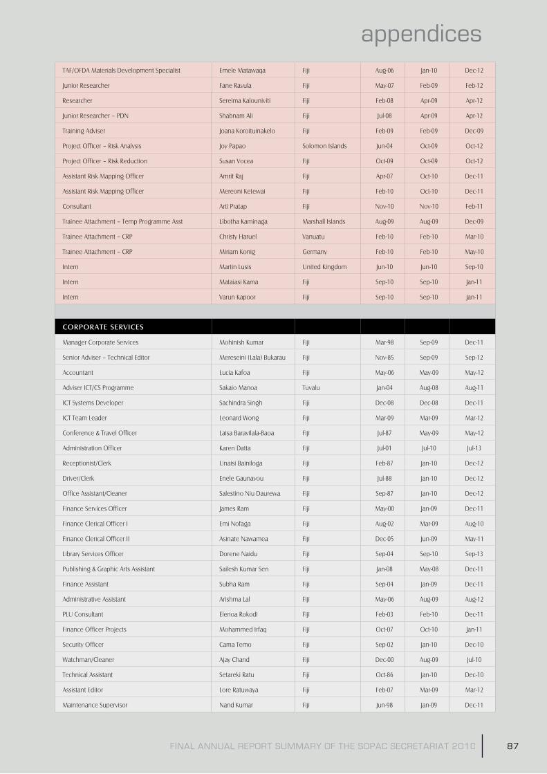
FINAL ANNUAL REPORT SUMMARY OF THE SOPAC SECRETARIAT 2010 87
appendicesTAF/OFDA Materials Development Specialist Emele Matawaqa Fiji Aug-06 Jan-10 Dec-12
Junior Researcher Fane Ravula Fiji May-07 Feb-09 Feb-12
Researcher Sereima Kalouniviti Fiji Feb-08 Apr-09 Apr-12
Junior Researcher – PDN Shabnam Ali Fiji Jul-08 Apr-09 Apr-12
Training Adviser Joana Koroituinakelo Fiji Feb-09 Feb-09 Dec-09
Project Officer – Risk Analysis Joy Papao Solomon Islands Jun-04 Oct-09 Oct-12
Project Officer – Risk Reduction Susan Vocea Fiji Oct-09 Oct-09 Oct-12
Assistant Risk Mapping Officer Amrit Raj Fiji Apr-07 Oct-10 Dec-11
Assistant Risk Mapping Officer Mereoni Ketewai Fiji Feb-10 Oct-10 Dec-11
Consultant Arti Pratap Fiji Nov-10 Nov-10 Feb-11
Trainee Attachment – Temp Programme Asst Libotha Kaminaga Marshall Islands Aug-09 Aug-09 Dec-09
Trainee Attachment – CRP Christy Haruel Vanuatu Feb-10 Feb-10 Mar-10
Trainee Attachment – CRP Miriam Konig Germany Feb-10 Feb-10 May-10
Intern Martin Lusis United Kingdom Jun-10 Jun-10 Sep-10
Intern Mataiasi Kama Fiji Sep-10 Sep-10 Jan-11
Intern Varun Kapoor Fiji Sep-10 Sep-10 Jan-11
�/9�/93"6��69%��6�
Manager Corporate Services Mohinish Kumar Fiji Mar-98 Sep-09 Dec-11
Senior Adviser – Technical Editor Mereseini (Lala) Bukarau Fiji Nov-85 Sep-09 Sep-12
Accountant Lucia Kafoa Fiji May-06 May-09 May-12
Adviser ICT/CS Programme Sakaio Manoa Tuvalu Jan-04 Aug-08 Aug-11
ICT Systems Developer Sachindra Singh Fiji Dec-08 Dec-08 Dec-11
ICT Team Leader Leonard Wong Fiji Mar-09 Mar-09 Mar-12
Conference & Travel Officer Laisa Baravilala-Baoa Fiji Jul-87 May-09 May-12
Administration Officer Karen Datta Fiji Jul-01 Jul-10 Jul-13
Receptionist/Clerk Unaisi Bainiloga Fiji Feb-87 Jan-10 Dec-12
Driver/Clerk Enele Gaunavou Fiji Jul-88 Jan-10 Dec-12
Office Assistant/Cleaner Salestino Niu Daurewa Fiji Sep-87 Jan-10 Dec-12
Finance Services Officer James Ram Fiji May-00 Jan-09 Dec-11
Finance Clerical Officer I Emi Nofaga Fiji Aug-02 Mar-09 Aug-10
Finance Clerical Officer II Asinate Nawamea Fiji Dec-05 Jun-09 May-11
Library Services Officer Dorene Naidu Fiji Sep-04 Sep-10 Sep-13
Publishing & Graphic Arts Assistant Sailesh Kumar Sen Fiji Jan-08 May-08 Dec-11
Finance Assistant Subha Ram Fiji Sep-04 Jan-09 Dec-11
Administrative Assistant Arishma Lal Fiji May-06 Aug-09 Aug-12
PLU Consultant Elenoa Rokodi Fiji Feb-03 Feb-10 Dec-11
Finance Officer Projects Mohammed Irfaq Fiji Oct-07 Oct-10 Jan-11
Security Officer Cama Temo Fiji Sep-02 Jan-10 Dec-10
Watchman/Cleaner Ajay Chand Fiji Dec-00 Aug-09 Jul-10
Technical Assistant Setareki Ratu Fiji Oct-86 Jan-10 Dec-10
Assistant Editor Lore Ratuwaya Fiji Feb-07 Mar-09 Mar-12
Maintenance Supervisor Nand Kumar Fiji Jun-98 Jan-09 Dec-11

FINAL ANNUAL REPORT SUMMARY OF THE SOPAC SECRETARIAT 201088
appendices
Gardner Are Waione Fiji Mar-96 Jan-10 Dec-10
Handyman Jitendra Sigh Fiji Mar-07 Jun-10 Dec-11
Handyman Alfred Singh Fiji Jun-08 Jun-10 Dec-11
Office Cleaner Reijeli Luma Fiji May-06 Jan-10 Dec-10
Finance Officer IV Roneel Kumar Fiji Feb-09 Feb-09 Feb-12
Finance Officer – Projects Assistant Shivani Pillay Fiji Feb-09 Feb-09 May-11
Project Officer – ICT Eliki Bula Fiji Feb-09 Aug-09 Aug-12
Programme Assistant – CS Miriama Turagava Fiji Feb-09 Feb-09 Dec-10
Consultant Katalaine Duiabe Fiji Jan-10 Jan-10 Dec-10
Trainee Attachment – ICT Digitaki Tuberi Fiji May-07 Jul-10 Dec-10
Trainee Attachment – ICT Lomaloma Pepine Tuvalu Jul-09 Jan-10 Feb-10
Trainee Attachment – ICT Naomi Jackson Fiji Sep-09 Jun-10 Dec-10
Trainee Attachment – ICT Paefou Panapa Tuvalu Jul-10 Jul-10 Jan-11
Trainee Attachment – ICT Peifaga Fuiono Tuvalu Jul-10 Jul-10 Jan-11
Trainee Attachment – PLU Arnold Navneet Lal Fiji Jan-08 Jan-10 Dec-10
Trainee Attachment – PLU Adi Loraini Baleilomaloma Fiji Sep-10 Sep-10 Dec-10
Trainee Attachment – PLU Eferemo Kubunavanua Fiji Sep-10 Sep-10 Dec-10
Trainee Attachment – PLU Manish Singh Fiji Sep-10 Sep-10 Dec-10
Trainee Attachment – PLU Rave Tuihe'a Fiji Sep-10 Sep-10 Dec-10
Trainee Attachment – Finance Shivani Nand Fiji Nov-10 Nov-10 Feb-11
Trainee Attachment – Finance Peni Turagacati Fiji Nov-10 Nov-10 Feb-11
TECHNICAL SUPPORT – GIS&RS
GIS – Remote Sensing Specialist Wolf Forstreuter Germany Jan-99 Jan-10 Dec-11
GIS – Remote Sensing Specialist (Utilities) Edwin Liava'a Tonga May-08 Nov-10 Dec-11
Project Officer GIS&RS Elizabeth Lomani Fiji Feb-04 Jan-08 Dec-10
Project Officer GIS&RS Vilisi Tokalauvere Fiji Feb-04 Jan-09 Dec-11
Project Officer GIS&RS Litia Gaunavou Fiji Jan-09 Jan-09 Jan-12
Project Officer – GIS&RS Vegetation Mapping Taato Murdoch Kiribati Dec-08 Jun-10 Dec-10
TECHNICAL SUPPORT – RESOURCE ECONOMICS
Manager – Natural Resources Paula Holland Australia Mar-06 Mar-09 Mar-12
ODI Resource Economist Federica Gerber Switzerland Oct-09 Oct-09 Oct-11
Resource Economist – Trainee Officer Deveraux Talagi Niue Aug-09 Jan-10 Dec-10

FINAL ANNUAL REPORT SUMMARY OF THE SOPAC SECRETARIAT 2010 89
appendicesAppendix 4: AcronymsACP – African, Caribbean and the Pacific countries (of the Lome Convention)
ADB/WB – Asian Development Bank & World Bank
ADRA – Adventist Development and Relief Agency
ALOS – Advanced Land Observing Satellite
APN – Asia-Pacific Network for Global Change Research
ASEAN – Association of Southeast Asian Nations
AusAID – Australian Agency for International Development
AWD – Asian Water Development
AWDO – Asian Water Development Outlook
BOM – Bureau of Meteorology (Australia)
CAP – Common Alert Protocol
CARICOM – Caribbean Community and Common Market
CBDRM – Community-Based Disaster Risk Management
CCOP/SOPAC – Committee for Coordination of Joint Prospecting for Mineral Resources in South Pacific Offshore Areas (now SOPAC)
CEO – Chief Executive Officer
CIP – Country Implementation Plan
CGPS – Continuous Global Positioning System
CLAIM – CROP Library, Archives and Information Management Working Group
CROP – Council of Regional Organisations of the Pacific (formerly SPOCC)
DM – Disaster Management
DRM – Disaster Risk Management
DRR – Disaster Risk Reduction
DTM – Digital Terrain Models
DWSP – Drinking Water Safety Planning
EC – European Commission
eCS – Extended Continental Shelf
EDMS – Electronic Data Management System
EDF – European Development Fund
EEZ – Exclusive Economic Zone
EIA – Environmental Impact Assessment
EMWIN – Emergency Managers Weather Information Network
EPA – Environment Protection Agency
EOC – Emergency Operations Centre
ESAT – Environmentally Sustainable Aggregates for Tarawa
EU – European Union
FACE – Funding Authorisation and Certificate of Expenditure
FAO – Food Agriculture Organisation (UN)
FEA – Fiji Electricity Authority
FFA – Forum Fisheries Agency
FFWS – Flood Forecasting and Warning System
FSM – Federated States of Micronesia
FSPI – Foundation for the Peoples of the South Pacific International
GA – Geoscience Australia
GB – Gigabytes
GC – Graduate Certificate
GDP – Gross Domestic Product
GEF – Global Environmental Facility
GEO5 – Global Environment Outlook 5 (EVI)
GFDRR – Global Facility for Disaster Reduction and Recovery
GFZ – GeoForschungZentrum [the German Government’s Research Centre for Geosciences]
GIS – Geographic Information Systems
GNS – Institute of Geological & Nuclear Sciences (of New Zealand)
GPA – Global Plan for Action for the Protection of the Marine Environment from Land-based Activities (UNEP)
GPS – Global Positioning System
HD – Hydrodynamic Modelling
HELP – Hydrology for Environment, Life and Policy
HR – Human Resources
HYCOS – Hydrological Cycle Observing System
IAS – Institute of Applied Sciences [of USP]
ICCAI – International Climate Change Adaptation Initiative (AusAID)
ICT – Information and Communication Technologies
ICU – [Pacific] Islands Climate Update (NZAID)
IDA – Initial Damage Assessment
IDM – Introduction to Disaster Management (course by TAF/ OFDA)
IFRC – International Federation of the Red Cross and Red Crescent Societies
IFREMER – Institut Francaise de Recherche pour l’Explotation de la Mer (formerly CNEXO)
IODE – International Oceanographic Data and Information Exchange
IOI – International Ocean Institute
ISOC – Internet Society
ISPRS – International Society for Photogrammetry and Remote Sensing
IT – Information Technology
IUCN – International Union for Conservation of Nature and Natural Resources (The World Conservation Union)
IWC – International Water Centre
IWRM – Integrated Water Resources Management
JICA – Japan International Co-operation Agency
JISR – Joint Information Services Review
J-PACE – Japan-Project Against Coastal Erosion
kVA – kilo volt-ampere (VA being unit for apparent power of electrical circuit)
LLEE – Live and Learn Environmental Education
LOA – Letter of Agreement
LPG – Liquid Petroleum Gas
MDG – Millennium Development Goals
MoA – Memoranda of Agreement
MOU – Memorandum of Understanding
NAPs – National Action Plans
NBCC – Nadi Basin Coordination Committee
NDC’s – National Disaster Council
NDMO – National Disaster Management Office (various countries)
NGOs – Non-Government Organisations
NHS – National Hydrological Services
NIWA – National Institute for Water and Atmospheric Research (New Zealand)

FINAL ANNUAL REPORT SUMMARY OF THE SOPAC SECRETARIAT 201090
appendices
NRE – Natural Resource Economics
NWRAP – National Water Resources Allocation Policy
NZAID – New Zealand Agency for International Development (formerly known as NZODA)
OCT – Overseas Countries and Territories (which are associated with the European Union)
OFDA – Office of US Foreign Disaster Assistance
OIP – Ocean and Islands Programme (SOPAC)
ONUP – Operational Network Upgrade Project
PACC – Pacific Adaptation to Climate Change
PCGIAP – Permanent Committee on GIS Infrastructure for Asia and the Pacific
PDN – Pacific Disaster Net
PDRMP – Pacific Disaster Risk Management Programme
PECCO – Pacific Environment and Climate Change Outlook
PEHRI – Pacific Enhanced Humanitarian Initiative
PGSP – Pacific Governance Support Program (AusAID) renamed Pacific Public Sector Linkages Program (2009)
PIC – Pacific Islands Countries
PICISOC – Pacific Islands Chapter of the Internet Society
PICPP – Pacific Island Climate Prediction Programme
PICTs – Pacific Islands Countries and Territories
PI-GOOS – Pacific Island Global Ocean Observing System
PIMRIS – Pacific Islands Marine Resources Information System
PIRMBIS – Pacific Islands Regional Maritime Boundaries Information System
PMEG – Programme Monitoring and Evaluation Group (SOPAC)
PMGO – Port Moresby Geophysical Observatory
PNG – Papua New Guinea
PPDRM – Pacific Platform for Disaster Risk Management
PPSLP – Pacific Public Sector Leadership Programme (AusAID)
PREEN – Pacific Resource and Environmental Economics Network (co-founded by SPC, SOPAC and IUCN)
PWVECA – Pacific Water Vulnerability Assessment
RAP – [Pacific] Regional Action Plan
REWS – Regional Early Warning Strategy
RIF – Regional Institutional Framework
RIP – Reference Image Points
ROC – Republic of China (Taiwan)
RSC – Regional Steering Committee (of UNESCO, IHP in the Asia-Pacific region)
SAT – Samoa Tala (currency unit)
SCOPIC – Seasonal Climate Outlooks for Pacific Island Countries
SCUBA – Self Contained Underwater Breathing Apparatus
SEAFRAME – Sea Level Fine Resolution Acoustic Measuring Equipment
SIDS – Small Island Developing States
SLMP – System Loss Management Plan
SMART – Specific, Measurable, Attainable, Relevant, Time-bound
SOP – Standard Operating Procedure
SOPAC – Pacific Islands Applied Geoscience Commission; and also Secretariat for the Pacific Islands Applied Geoscience Commission
SPC – Secretariat of the Pacific Community
SPLOS – States Parties to the United Nations Convention on the Law of the Sea
SPREP – Secretariat of the Pacific Regional Environment Programme
SPSLCMP – South Pacific Sea Level and Climate Monitoring Project
STAR – Science, Technology and Resources Network
TAF – The Asia Foundation
TANGO – Tuvalu Association of Non-Governmental Organisations
TCC – Tonga Communications Corporation
TCDT – Tonga Community Development Trust (now called Tonga Trust)
TOR – Terms of Reference
UK – United Kingdom
UN – United Nations
UNCLCS – United Nations Commission on the Limits of the Continental Shelf
UNCLOS – United Nations Convention on the Law of the Sea
UNDOALOS – United Nations Office of Legal Affairs/Division for Ocean Affairs and the Law of the Sea
UNDP – United Nations Development Programme
UNEP – United Nations Environment Programme
UNEP GRID – Global Resource Information Database
UNESCAP – United Nations Economic and Social Commission for Asia and the Pacific
UNESCO – United Nations Educational Scientific and Cultural Organisation
UNESCO-IHE – Institute for Water Education
UN-HABITAT – United Nations Human Settlements Programme
UNICEF – United Nations Children’s Fund
UNISD – United Nations International Strategy for Disaster Reduction
UNOCHA – United Nations Office for the Coordination of Humanitarian Affairs (formerly UNDHA)
UN-SPIDER – UN Platform for Space-based Information for Disaster Management and Emergency Response
USA – United States of America
USAID – United States Agency for International Development
USP – University of the South Pacific
VHR – Very High Resolution
WAF – Water Authority of Fiji
WASH – Water Sanitation Hygiene
WASSP – Water Sector Support Programme
WB – World Bank
WDM – Water Demand Management
WHO – World Health Organisation
WMO – World Meteorological Organisation
WQM – Water Quality Monitoring
WSP – Water and Sanitation Programme (of SOPAC)
WSP – Water Safety Plan(ning)
WSSCC – Water Supply and Sanitation Collaborative Council
WUE – Water Use Efficiency

91
appendices
Printed by Quality Print Limited

92