field survey of tsunami stricken areas in the mentawai ... islands tsunami... · mentawai is tua...
TRANSCRIPT
JICA-JST Indonesia Multi-disciplinary Hazard Reduction from Earthquakes and Volcanoes in Indonesia
5th– 10th November, 2010
Field Survey of Tsunami Stricken Areas in the Mentawai Islands:
focusing on policy aspects
Atsushi KoresawaAsian Disaster Reduction Center (ADRC)

Mentawai Islands Tsunami SurveyMembers of MissionGroup1‐2 Yuichi Nishimura, Purna Putra (Hokkaido Univ.), Eko Yulianto (LIPI)Group 1‐6 Kenji Satake (Tokyo Univ.), Haris Sunendar (ITB)Group 3‐1 Megumi Sugimoto (Tokyo Univ.), Mulyo Harris Pradono (BPPT)Group 6 Atsushi Koresawa (ADRC), Pariatmono (RISTEK)
ObjectivesGroup1‐2, 1‐6 focus on: Tsunami inundation height and areas, Tsunami deposits
Groups 3, 6 focus on: Interview to refugees and local government officials on immediate response, early warning, education, etc.
Time line3 Nov. Narita, Japan – Jakarta, Indonesia4 Nov. Visit at LIPI, Jakarta ‐ Padang5‐10 Nov. Survey on Mentawai Islands by ship10 Nov. Padang – Jakarta, Presentation to RISTEK, UNESCO, Media

Mentawai Tsunami Survey
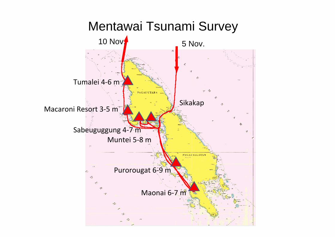
Mentawai Tsunami Survey
Sikakap
Maonai 6‐7 m
Sabeuguggung 4‐7 mMuntei 5‐8 m
Macaroni Resort 3‐5 m
Tumalei 4‐6 m
Purorougat 6‐9 m
5 Nov. 10 Nov.

Summary Table
02.5 LakauPagai Selatan
Pagai Utara
Kecamatan
Bulasat
Malakopak
Metumonga
Silabu
Desa Dusun Tsunami heights Pop Casualty
Tumalei 6.1, 5.5, 5.2, 4.7, 4.0
199 5
Macaronis resort
5.4, 4.9, 4.8, 3.83.0, 2.9 (water mark)
~20 visitors
1
Sabeu Guggung 7.0, 5.8, 5.0, 4.3 258 121Muntei 7.8, 5.7, 5.1, 4.6,
4.6, 4.6, 4.6314 114
Muntei coast 8.8, 6.8, 4.5, 3.9Purorougat 5.5 (flow depth) 235 72
Asahan 6.4, 6.6, 9.3 0Maonai 6.9, 6.8, 6.7, 6.3 139 35
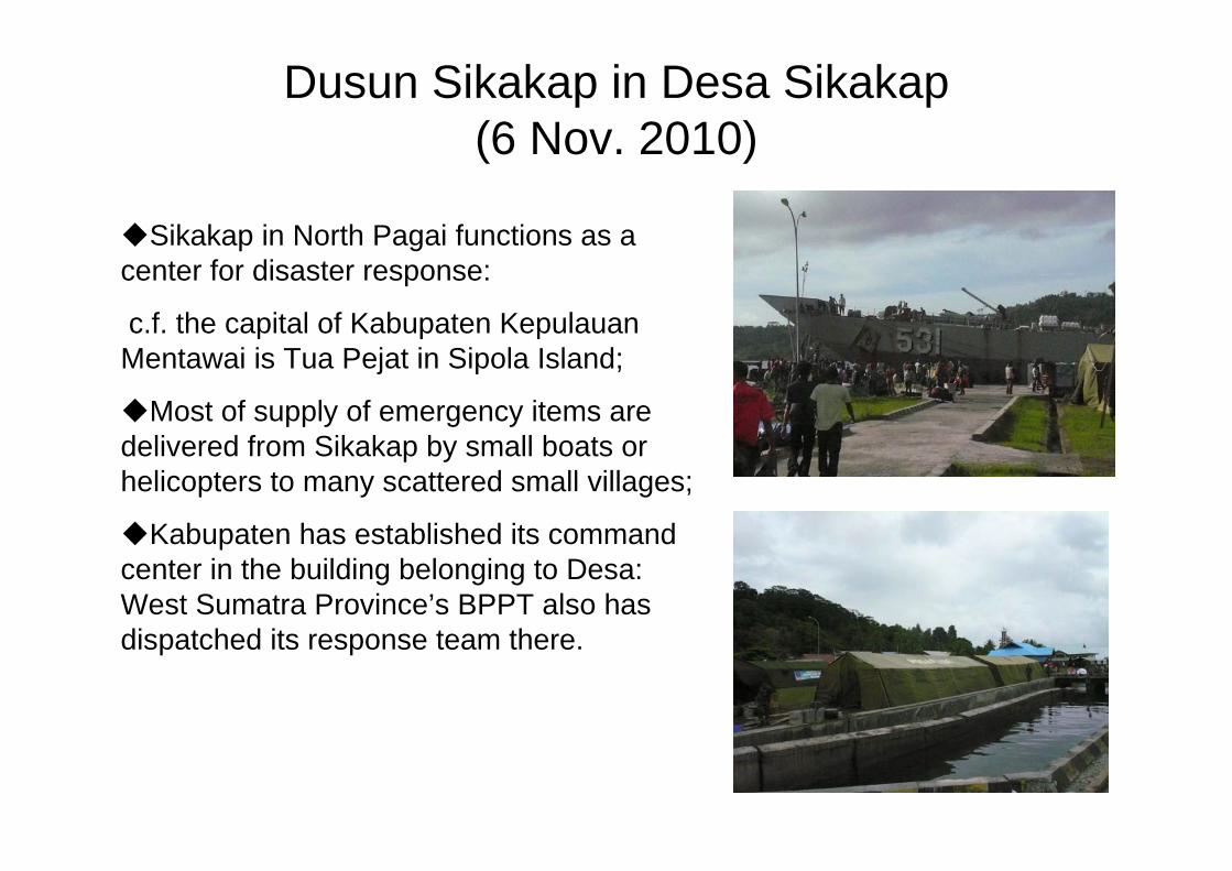
Dusun Sikakap in Desa Sikakap(6 Nov. 2010)
Sikakap in North Pagai functions as a center for disaster response:
c.f. the capital of Kabupaten KepulauanMentawai is Tua Pejat in Sipola Island;
Most of supply of emergency items are delivered from Sikakap by small boats or helicopters to many scattered small villages;
Kabupaten has established its command center in the building belonging to Desa: West Sumatra Province’s BPPT also has dispatched its response team there.
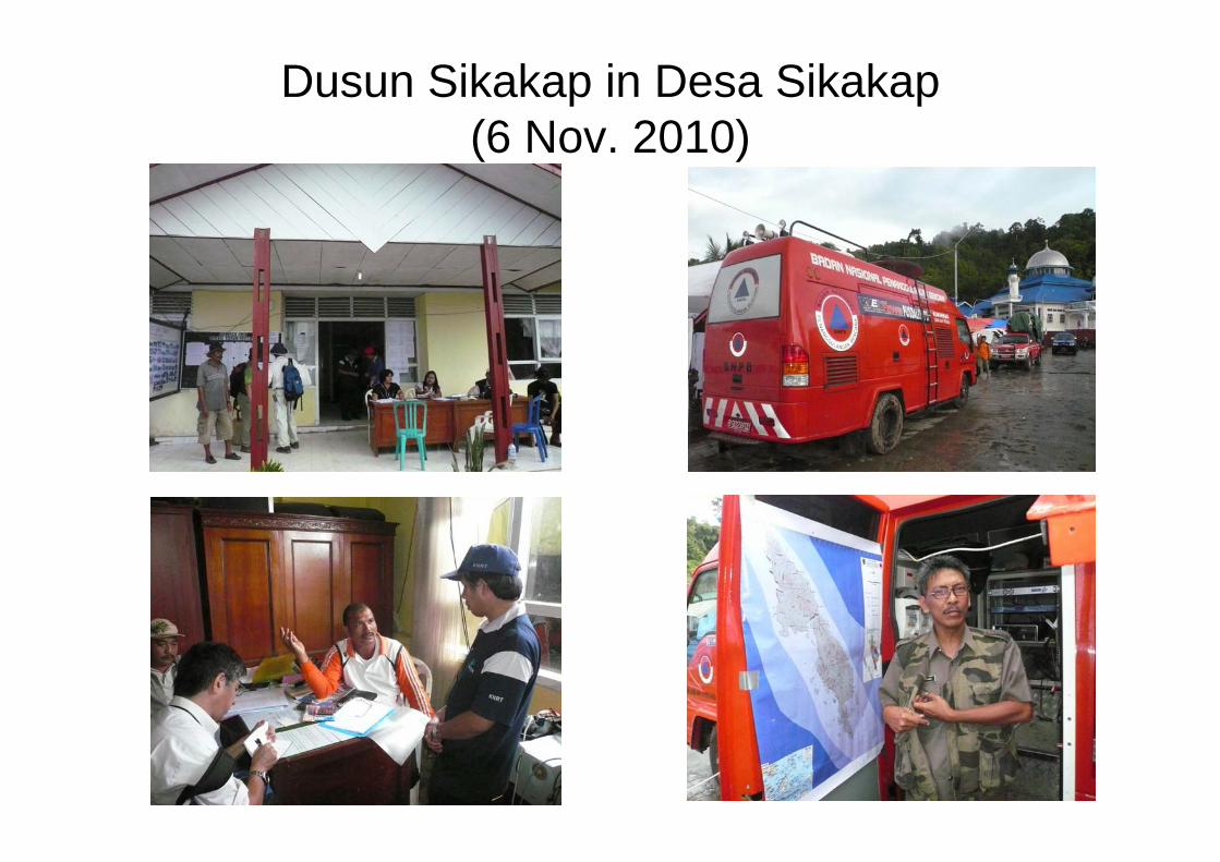
Dusun Sikakap in Desa Sikakap(6 Nov. 2010)

Dusun Sikakap in Desa Sikakap(6 Nov. 2010)
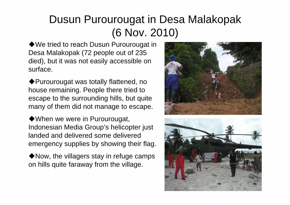
Dusun Purourougat in Desa Malakopak(6 Nov. 2010)
We tried to reach Dusun Purourougat in Desa Malakopak (72 people out of 235 died), but it was not easily accessible on surface.
Purourougat was totally flattened, no house remaining. People there tried to escape to the surrounding hills, but quite many of them did not manage to escape.
When we were in Purourougat, Indonesian Media Group’s helicopter just landed and delivered some delivered emergency supplies by showing their flag.
Now, the villagers stay in refuge camps on hills quite faraway from the village.

Dusun Maonai in Desa Bulasat (7 Nov. 2010)
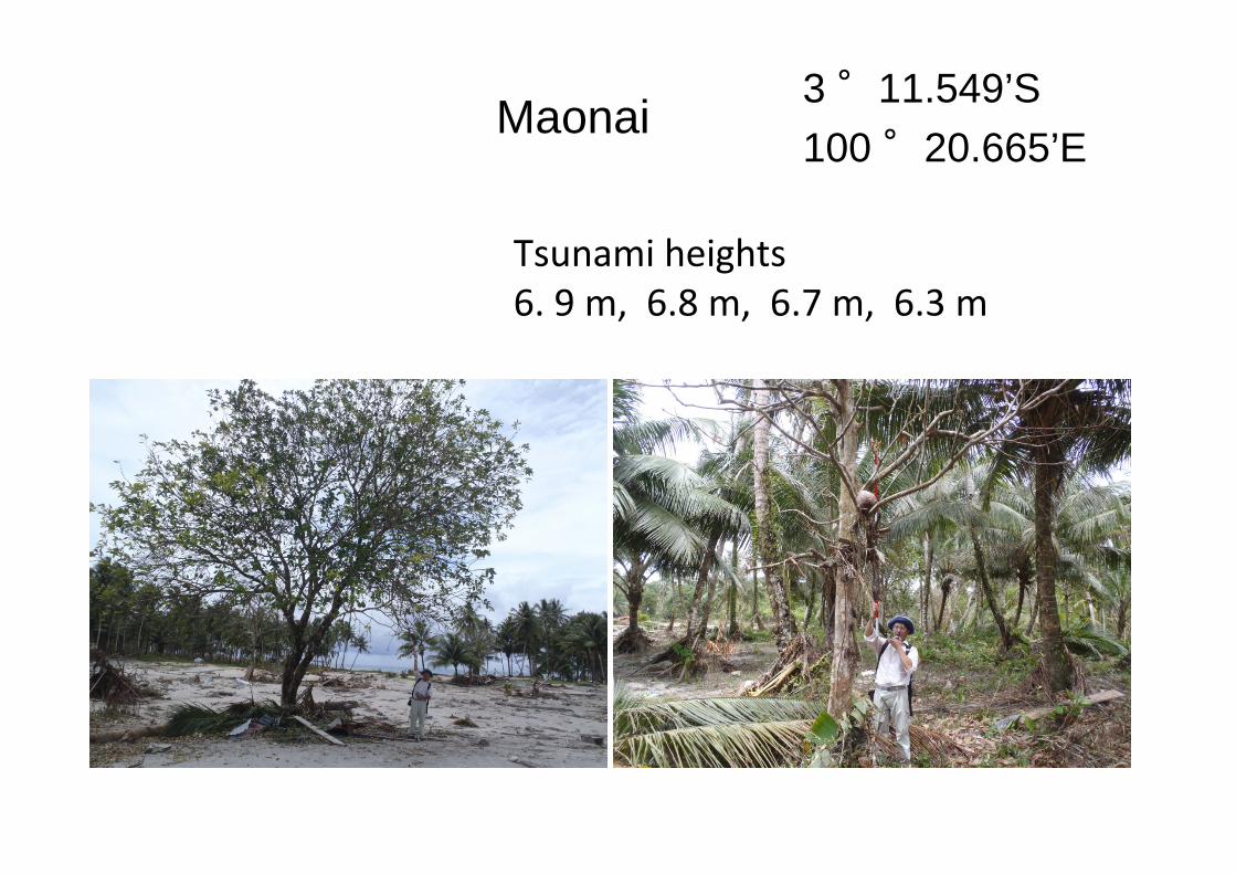
Maonai 3 °11.549’S100 °20.665’E
Tsunami heights6. 9 m, 6.8 m, 6.7 m, 6.3 m
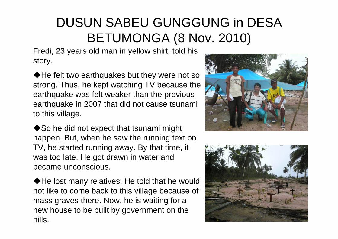
DUSUN SABEU GUNGGUNG in DESA BETUMONGA (8 Nov. 2010)
Fredi, 23 years old man in yellow shirt, told his story.
He felt two earthquakes but they were not so strong. Thus, he kept watching TV because the earthquake was felt weaker than the previous earthquake in 2007 that did not cause tsunami to this village.
So he did not expect that tsunami might happen. But, when he saw the running text on TV, he started running away. By that time, it was too late. He got drawn in water and became unconscious.
He lost many relatives. He told that he would not like to come back to this village because of mass graves there. Now, he is waiting for a new house to be built by government on the hills.
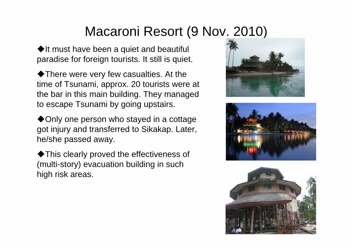
Macaroni Resort (9 Nov. 2010)It must have been a quiet and beautiful
paradise for foreign tourists. It still is quiet.
There were very few casualties. At the time of Tsunami, approx. 20 tourists were at the bar in this main building. They managed to escape Tsunami by going upstairs.
Only one person who stayed in a cottage got injury and transferred to Sikakap. Later, he/she passed away.
This clearly proved the effectiveness of (multi-story) evacuation building in such high risk areas.

Dusun Tumarei in Desa Silabu (9 Nov. 2010) Tumarei was totally flattened by
Tsunami. Surprisingly, only 5 out of 199 villagers died because they managed to escape Tsunami by climbing up hills just behind the village.
They also received some tsunami training beforehand which provided by Indonesian and Australian groups. Moreover, based on training they received, the villagers formed different disaster preparedness/response teams and continued exercises/drills.
Eventually, both topographical conditions and their preparedness proved to be effective to save lives in this village.
They receive sufficient food and water from NGOs, but such items as cooking stoves, oil, clothes, cigarettes are missing.
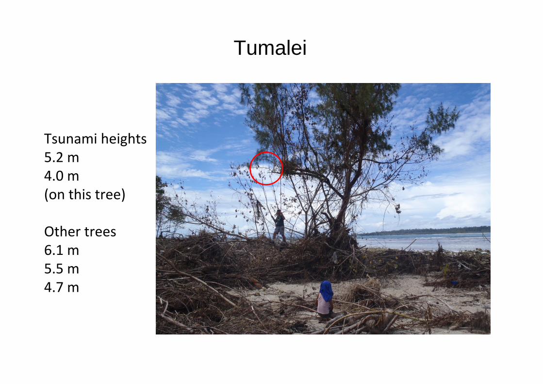
Tumalei
Tsunami heights5.2 m4.0 m(on this tree)
Other trees6.1 m5.5 m4.7 m
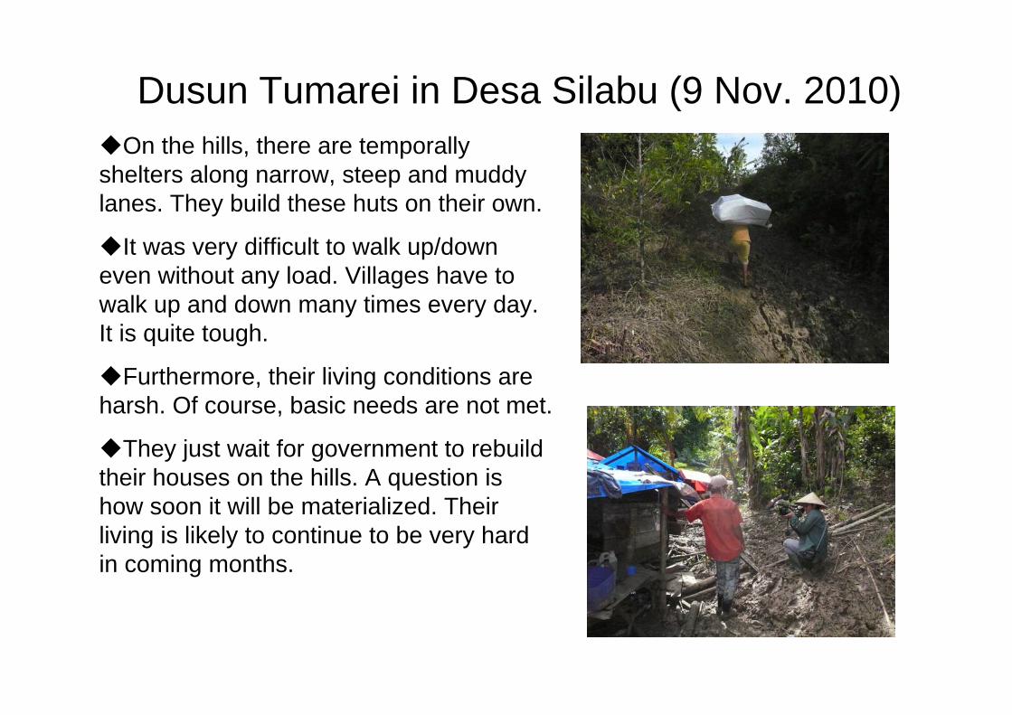
Dusun Tumarei in Desa Silabu (9 Nov. 2010) On the hills, there are temporally
shelters along narrow, steep and muddy lanes. They build these huts on their own.
It was very difficult to walk up/down even without any load. Villages have to walk up and down many times every day. It is quite tough.
Furthermore, their living conditions are harsh. Of course, basic needs are not met.
They just wait for government to rebuild their houses on the hills. A question is how soon it will be materialized. Their living is likely to continue to be very hard in coming months.

Points of Consideration (1/2)Remote areas such as Mentawai Islands are particularly difficult for
humanitarian support to be reached: Indeed, many NGOs have left there without carrying out their tasks because of lack of transportation means;
Relocation of high risk communities on the coast to safer higher grounds is desirable, but given its large number, it may be very difficult or take much time to be fully implemented for all high risks areas;
Therefore, while relocation is promoted, it is imperative to secure evacuation routes and evacuation buildings in high risk areas as a matter of urgency: Evacuation routes are effective if they can help people quickly run up to nearby higher ground: Moreover, evacuation buildings are also effective in case there is no such higher ground nearby (for all these, risk assessment of coastal villages is a first step);
Some kind of warning system is necessary, and they can be facilitated by making use of ordinary means, such as TV, radio, etc.
To use those facilities effectively, awareness raising activities, disaster education and disaster preparedness should be further enhanced;

Points of Consideration (2/2)It may be the case that currently operating NGOs may terminate its
activities in coming weeks. Early recovery of not only housing but also livelihood is required, but how soon can it be materialized?
Disaster victims are currently in extremely harsh living conditions, and thus massive mobilization of government’s resources should be expedited together with support by international and bilateral organizations;
In highly disaster prone countries like Indonesia, some kind of risk sharing scheme may be necessary, which cannot be run on a commercial basis: thus, government’s intervention is necessary;
The capacity of disaster management agencies at various levels, from national to local levels as well as community groups should be further strengthened: it should cover not only disaster response phase but also mitigation, preparedness, and early- and long-term recovery phases.