field findings 2015
TRANSCRIPT
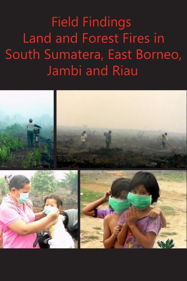
Field Findings
in South Sumatera, East Kalimantan, Jambi and Riau
1
Land and Forest Fires in
South Sumatera, East Borneo,
Jambi and Riau

2
Field Findings Forest and Land Fires
Field Findings
Forest and Land Fires in South
Sumatera, East Kalimantan,
Jambi and Riau
Sawit Watch
2015
Issues on land and forest fires as well smoke disaster in Sumatera and Kalimantan have enlivened headline news for the last several months. Each year, the news related to issues on land and forest fires never ends. The news raised during dry season with intentional purpose and negligence of certain holders are written, then the news will calm down during rainy season. The same patter will repeat each and every year. It seems never ending vicious circle and without real solution to break the circle. Perhaps for central government, this situation is merely a regular disaster, but it is not for people who inhale the smoke each year. It influences the environment and health for the people and it disturbs their daily activity without knowing when and how they can end this annual suffering.
Forest and land fires actually are part of Indonesian history. Forest and land fire with huge scale started in 1982/1983 in area of East Kalimantan. Land fire with width of 3.6 million hectare happened since there was changes of vegetation as an impact of illegal logging. Forest and land fires did not stop on that year. In 1997/1998, the biggest fire happened in the Indonesian history. The fire burnt in almost 10 million hectare of land in Sumatra, Kalimantan, Sulawesi, Java and Papua. Since 1997/1998, forest and land fires as well haze have become headline news almost each year. The government’s initiative to stop totally smoke disaster is merely an initiative. In reality, until 2015 no steps taken by government are proven to stop forests and land fires. The absence of firm step from the government to punish forest arsonists seriously makes the cycle of forest fires will occur continuously every year.
In fact, it is stated clearly in article 28H verse 1 of the Constitution 1945 of the Unitary State of Republic of Indonesia “Each person has the rights to live inner and outer prosperously, to have shelter, and

in South Sumatera, East Kalimantan, Jambi and Riau
3
to get good and healthy living environment as well to have health services” The Constitution 1945 clearly ensures the rights of each citizen of Indonesia to have healthy living environment and the government is obliged to guarantee those matters. However, since 1997/1998, the forest and land fires happened continuously every year and become routine agenda of Indonesian, especially people in Sumatera and Kalimatan. They are citizens of Indonesia whose rights are guaranteed by the constitution and the government is obliged to ensure the rights of its citizens are fulfilled. Nevertheless, shall this situation happen continuously and the rights of the people are violated and seized, then the government’s commitment to ensure and protect the rights of its citizens must be questioned.
The last September, team of Sawit Watch conducted its research trip about forest and/or land fires in Sumatera and Kalimantan. This research trip is aimed to verify data about hotspots in areas of Sumatera and Kalimantan. Besides, the research trip is aimed also to collect data on impact of forest and/or land fires from health and education point of views. The research was conducted in four provinces; they are Province of South Sumatera, Province of Jambi, Province of East Kalimantan and province of Riau.
Province of South Sumatera 1. District of Ogan Komering Ilir (OKI) 1.1 PT. Tania Selatan
Picture 1. Land fires in the plantation concession of PT. Tania
Selatan Ordinate point: 3o 30’ 58.29” LS 104o 41’ 20.74” BT.

4
Field Findings Forest and Land Fires
PT. Tania Selatan is palm oil plantation enterprise which was initially operated and owned by Tania Group. The plantation was then sold partially to Wilmar Internasional Group and another to Sampoerna Group in 2002. In the beginning PT. Tania Selatan was managed and owned by Tania Group, and operated with Decree No. 258/Kpts/KB.320/4/90 from Ministry of Agriculture. The decree was issued in order to implement a project from plasma plantation – transmigration (Perkebunan Inti Rakyat-Transmigrasi/PIR – Trans). It is a project on developing palm oil by minor farmers in Sub District of Lem-puing and Sub District of Tanjung Lubuk from District of Ogan Komering Ilir. In 2002, Wilmar Group purchased a portion of area from Tania Group (whilst Sampoerna Group purchased the remains). Wilmar Internasional Group is from Singapore and registered as a member of RSPO (Roundtable on Sustainable Palm Oil) since 15 Agustus 2015.
The team collected data in District of OKI OKI, especially in plantation consession of PT. Tania Selatan located in Village of Tanjung Beringin, Sub District of Tanjung Lubuk. From the field findings, the first hotspot visited by the team was still active to smoke and even there were fires exploding out of peat. Team took pictures and video as documentation of the hotspots for several minutes and continued to the next hotspot which was located about 500 meters away. Only few activities done by community who were labors of palm oil plantations of PT. Tania Selatan.
The team arrived in the next spot about 18.15 Western Indonesian Time. The second hotspot was still active to smoke and in several spots were explosive fires too. The team found difficult to document the fires of this second hotspot since it was late night already.
The team monitored the situation, there was no activity to manage the fires of the peat land fired within palm oil plantation concession of PT. Tania Selatan. Besides, the teacm also did not find any facilities and infrastructures to prevent and to manage land fires within plantation concession of PT. Tania Selatan.
From the technical side, it was very fortunate that the team came late to the location of hotspots of PT. Tania Selatan. The tardiness of the team affected to its work, for example the quality of documentation of the fired land was not good. Besides, the tardiness also affected to the lack of quality of verification of hotspots conducted by the team. Due to the tardiness, the team could not reach the hotspots stated by the coordinates. The team stayed about 500 meters of the hotspots within the concession of PT. Tania Selatan recorded in GPS, S 03.54000 E 104.67100.

in South Sumatera, East Kalimantan, Jambi and Riau
5
1.2 PT. Sampoerna Agro Lestari PT. Sampoerna Agro is located in District of Ogan Komering Ilir,
Province of South Sumatera. It is a member of RSPO. PT. Sampoerna Agro has subordinate companies. They are PT. Aek Tarum, PT. Mutiara Bunda Jaya, PT. Gunung Tua Abadi, PT. Sampoerna Agro, PT. Telaga Hikmah, and PT. Sungai Rangit. Each subordinate companies has certificate from RSPO. PT. Sampoerna Agro has become a member of RSPO since 10 January 2007. At the end of 2014, Sampoerna Agro Group has managed in total of 127.787 hectares of palm oil plantations; 87.401 hectares of the areas were planted with palm oil in Province of South Sumatera and 40.386 hectares are located in Province of Central Kalimantan and Province of West Kalimantan.
Based on the preliminary data from secretariat of Sawit Watch, the hotspot of PT. Sampoerna Agro Lestari was located in coordinate of S 03.50200 E 104.91700, Village of Menang Raya, Sub District of Pedamaran. About 9.00 am of Western Indonesian Time, the team departed to the coordinate point with GPS aid. The team had its trip to the hotspot of PT. Sampoerna Agro Lestari and also passed concession of PT. Tempirai Palm Resources which was once visited by President Joko Widodo in the last September. The hotspot of PT. Sampoerna Agro Lestari was located closely to the hotspot of PT. Rambang Agro Jaya; both companies are subordinate companies of Sampoerna Agro Group.
Picture 2. The new palm trees that grow on the burnt land in
concession. PT. Sampoerna Agro Lestari. Ordinate point: 3o 30’
15.07” LS 104o 55’ 40.99” BT
6
Field Findings Forest and Land Fires
The field finding of the hotspot of PT. Sampoerna Agro Lestari indicated that the land of palm oil plantations of PT. Sampoerna Agro Lestari had been burnt for more than a year. It could be seen from the former fires, but not all land was burnt since there were green bushes in surrounding areas. Besides, there were smaller palm oil plants which were not burnt. Based on the finding, the team had interim conclusion that the land of PT. Sampoerna Agro Lestari was not burnt this year.
2. District of Banyuasin 2.1 PT. Sri Andal Lestari PT. Sri Andal Lestari along with other companies joined PT.
Buana Sriwijaya Sejahtera Group. The company has palm oil as its commodity. Palm oil plantation was located in Betung, Tanjung Laut, District of Banyuasin with areas of 9.500 hectares.
Monitoring of hotspots located in PT. Sri Andal Lestari was conducted on the last day of the visit of two districts, id est. District of Banyuasin and District of Musi Banyuasin. From the total of 28 hotspots in the concession of PT. Sri Andal Lestari, the team visited coordinate point of S 02.77900 E 104.41300 located in Village of Sedang Sub District of Betung. The team departed to the spot at noon or about 12.00 Western Indonesian Time, after visiting two services, Health Service and Education Service of District of Musi Banyuasin.
The team could not reach the hotspots mentioned above since there were security guards from PT. Sri Andal Lestari. Providing security reasons and smoothness of data collection, team stated to the security guards of PT. Sri Andal Lestari that the team only would like to dine at coffee shop close to portal of entrance gate of PT. Sri Andal Lestari. The distance from the coffee shop to the hotspots of PT. Sri Andal Lestari was about one to two kilometers away.
3. District of Musi Banyuasin 3.1 PT. Inti Megah Bestari Pertiwi It is a joint venture company between PT. Indoagri Inti Plantation
and PT. Serikat Putra. After the acquisition, PT. Intimegah became the subordinate company of Indofood Agri. Meanwhile, Indofood Agri is subordinate company of PT Indofood Sukses Makmur Tbk. On 22 November 2012, PT. Inti Megah had certification from RSPO to add 53.000 ton of CPO. Therefore, the total of CPO certified within the group reached 248.000 ton. PT Inti Megah Bestari Pertiwi is registered as location of plantation of Indofood Agri Resource written in their annual report of 2012, with location of plantation of
in South Sumatera, East Kalimantan, Jambi and Riau
7
Sungai Ampalau and Megah Abadi in South Sumatera. It is located in Village of Sungai Keruh, Sub District of Sanga with Plantation Permit of 365/Kpts/IUP/Disbun/08 for 10.000 hectares.
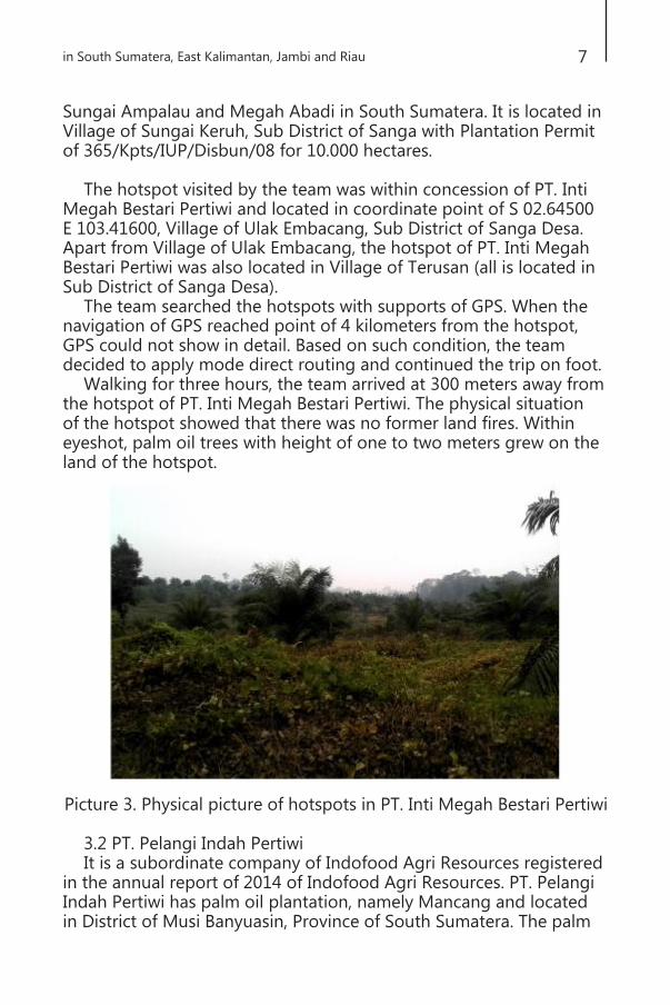
The hotspot visited by the team was within concession of PT. Inti
Megah Bestari Pertiwi and located in coordinate point of S 02.64500 E 103.41600, Village of Ulak Embacang, Sub District of Sanga Desa. Apart from Village of Ulak Embacang, the hotspot of PT. Inti Megah Bestari Pertiwi was also located in Village of Terusan (all is located in Sub District of Sanga Desa).
The team searched the hotspots with supports of GPS. When the navigation of GPS reached point of 4 kilometers from the hotspot, GPS could not show in detail. Based on such condition, the team decided to apply mode direct routing and continued the trip on foot.
Walking for three hours, the team arrived at 300 meters away from the hotspot of PT. Inti Megah Bestari Pertiwi. The physical situation of the hotspot showed that there was no former land fires. Within eyeshot, palm oil trees with height of one to two meters grew on the land of the hotspot.
Picture 3. Physical picture of hotspots in PT. Inti Megah Bestari Pertiwi
3.2 PT. Pelangi Indah Pertiwi It is a subordinate company of Indofood Agri Resources registered
in the annual report of 2014 of Indofood Agri Resources. PT. Pelangi Indah Pertiwi has palm oil plantation, namely Mancang and located in District of Musi Banyuasin, Province of South Sumatera. The palm

8
Field Findings Forest and Land Fires
oil plantation of PT Pelangi Indah Pertiwi is located in Batang Hari Leko with Decree of IUP Number 365/Kpts/IUP/Disbun/08 dated on 13 March 2008 with areas of 10.000 hectares.
Actually the team did not plan to monitor the hotspots under concession of PT. Pelangi Indah Pertiwi before the team departed to District of Musi Banyuasin. However, when the team walked on foot to the parking lot, the team found former fires of the land around palm oil plantation of PT. Inti Megah Bestari Pertiwi. The distance between the hotspot of PT. Inti Megah Bestari Pertiwi with the former land fires was about 500 – 800 meters to the north. At that time, the team did not know whether the former fires were under concession of plantation of PT. Inti Megah Bestari Pertiwi. There was presumption proposed by local partner that the former fire was on the land possessed by the community since the fires areas were not wide. Meanwhile, the team took pictures and video for documentations and also recorded the coordinate of the fire on GPS as the base to monitor the fire whether the fire was in the land of the company.
Picture 4. Fires in the former concession of PT. Pelangi Indah Pertiwi.
Ordinate point: 2o 37’ 59.79” LS 103o 25’ 32.04”
The presumption of the team that the former fire presented on the above picture was under concession of PT. Pelangi Indah Pertiwi was based on information delivered by the society living in Division 5 (village or settlement close to areas of plantations of PT. Inti Megah Bestari Pertiwi dan PT. Pelangi Indah Pertiwi). The team had time to rest and lunch in a food stall within Division 5 and had discussion with local people. One of them said that the settlement in Division 5 was close to plantation of PT. Pelangi Indah Pertiwi. The distance

in South Sumatera, East Kalimantan, Jambi and Riau
9
between Division 5 with the former fire of plantation showed in the picture was about 800 – 1000 meters. To add, PT. Inti Megah Bestari Pertiwi and PT. Pelangi Indah Pertiwi are subordinate companies of Group Indofood Agri Resources which are members of RSPO.
4. Impacts of Forest Fires of South Sumatera in some sectors Health Sector The haze due to fire affected health sector. It happened in District
of Ogan Komering Ilir (OKI). Based on the data we collected from Health Service of District of OKI, in early year of 2015, there were 5.200 patients of URI (Upper Respiratory Tract Infection). Per period of June to August 2015, the numbers of URI patients increased from 4360 to 4702 and finally reached 4772 patients in August. Though the numbers did not show surge in number significantly, however it must be taken into consideration in order to reduce number of URI. To compare, the data of URI in 2014 and 2015 can be seen in the following picture:
Data of URI patients in period of June to August in District of OKI is collected from each primary health care center can be seen on the
following graphic:
10
Field Findings Forest and Land Fires
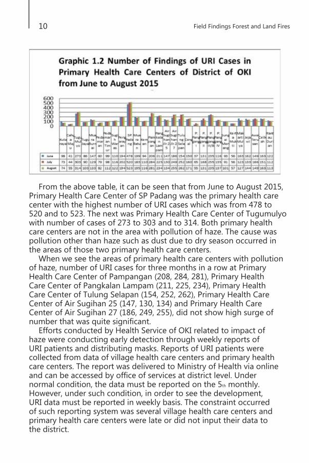
From the above table, it can be seen that from June to August 2015, Primary Health Care Center of SP Padang was the primary health care center with the highest number of URI cases which was from 478 to 520 and to 523. The next was Primary Health Care Center of Tugumulyo with number of cases of 273 to 303 and to 314. Both primary health care centers are not in the area with pollution of haze. The cause was pollution other than haze such as dust due to dry season occurred in the areas of those two primary health care centers.
When we see the areas of primary health care centers with pollution of haze, number of URI cases for three months in a row at Primary Health Care Center of Pampangan (208, 284, 281), Primary Health Care Center of Pangkalan Lampam (211, 225, 234), Primary Health Care Center of Tulung Selapan (154, 252, 262), Primary Health Care Center of Air Sugihan 25 (147, 130, 134) and Primary Health Care Center of Air Sugihan 27 (186, 249, 255), did not show high surge of number that was quite significant.
Efforts conducted by Health Service of OKI related to impact of haze were conducting early detection through weekly reports of URI patients and distributing masks. Reports of URI patients were collected from data of village health care centers and primary health care centers. The report was delivered to Ministry of Health via online and can be accessed by office of services at district level. Under normal condition, the data must be reported on the 5th monthly. However, under such condition, in order to see the development, URI data must be reported in weekly basis. The constraint occurred of such reporting system was several village health care centers and primary health care centers were late or did not input their data to the district.

in South Sumatera, East Kalimantan, Jambi and Riau
11
Health Office of District of Ogan Komering Ilir have prepared mask to be distributed in 2015. Up to now, there were about 45000 masks were distributed to society. Target group as the main priority of Health Service was vulnerable group effected by URI, such as pregnant women, breastfeeding women, children, elderly people, and road users. For those concerned about haze and willing to distribute masks were given the opportunity. Health Service had the initiative to ask about the contribution of palm oil towards haze issue. The outcome was several companies provided masks. Those companies were PT. Tania Selatan and PT. Sampoerna Agro; each provided 4000 and 5000 masks respectively. Basically, companies provided masks after Health Service requested their participations. There was no awareness and no direct initiative given by the companies.
Education Sector Education Service of Province of South Sumatera took some
initiatives related to haze continuously occurred in the last months. The presence of haze was very disturbing for learning process at school. Education Service of Province of South Sumatera published circular letter addressed to Head of Education Service of Municipality/District about learning hours. The circular letter was an appeal, the decision was fully given to Education Service at District/Municipality level. The content of the circular letter dated on 15 September 2015 was: Haze has reached its level of equity in six districts/municipality of
Palembang, OKI, OI, Banyuasin, Musi Banyuasin, and some parts of Muara Enim. Whilst in other 11 districts/municipality of Ogan Komering Ulu (OKU), East OKU, South OKU, Prabumulih, PALI, Lahat, Pagar Alam, Empat Lawang, Musi Rawas, Lubuk Linggau, and Muratara under normal condition.
(1) The areas with normal category not affected by haze had normal learning process. (2) The areas with medium category affected by haze had learning process with school hours were postponed and wore masks attending school. (3) The areas with dangerous category, learning process was facultative, that is the students were given tasks based on the subjects to work at home.
Heads of Health Service of District/Municipality were requested to coordinate with Health Service and Environment Agency in order to determine the status/category whether the area was still healthy or dangerous in order to ensure health condition for the comfort of students during the learning process.
Education Service of Municipality of Palembang in September
decided two policies in handling haze which was gradually

12
Field Findings Forest and Land Fires
disturbing learning process. The first policy was Education Service of Municipality of Palembang provided facultative condition to have learning process for 3 days in a week. The second policy was to have learning process for 2 days in a week. The aim of learning status to become facultative is to reduce negative impact of haze to students’ health. Due to the condition of haze which happened continuously, the Mayor of Palembang along with Head of Education Service decided not to have facultative learning processes, but to set back the learning hours. It was the option for the students were not felt behind classes since within short time they had to face Mid Term Test. The alternates of school hours were 07.30 am, 08.00 am and 08.30 am. Another effort implemented by schools in order to reduce the impacts of haze towards students was to nullify outdoor activities, such as sports and raising flag ceremony.
Shortly, school committee must recognize each policy taken by school. Through this committee, all information about students could be delivered to parents. Information from school to the committee was delivered through short message services since the delivered information was urgent and required fast response to parents. For Early Childhood Education and Development (Pendidikan Anak Usia Dini/PAUD) level, kindergarten level, class 1 – 3 of Elementary School level, the information could be delivered through Linking Book in which the book provided information/messages from school to parents.
East Kalimantan 1. District of Paser 1.1 PT. Langgeng Muara Makmur PT. Langgeng Muara Makmur is subordinate company of Minamas
which is subsidiary of Sime Darby from Malaysia. It is registered as member of RSPO. Sime Darby has at least 280,274 hectares in Indonesia. Sime Darby started in 1910 and focused on palm oil plantation and cocoa. In November 2007, Kumpulan Sime Darby Berhad merged with big plantation called Golden Hope Plantation Berhad and Kumpulan Guthrie Berhad with new identity called Sime Darby Berhad with total market capital reaching USD$ 13.3 billion on 24 July 2015.1
Sime Darby Plantation is one of biggest producers of palm oil plantation in the world with production reaching to 2.8 million or 5% of total production of CPO per year, in which 97% or about
1
http://www.simedarbyplantation.com/Upstream_Overview.aspx
in South Sumatera, East Kalimantan, Jambi and Riau
13
2.7 million ton was palm oil with sustainable certification (certified Sustainable Palm Oil).2 Twenty four out of 25 plantation Sime Darby enterprises in Indonesia received certificate of Roundtable on Sustainable Palm Oil (RSPO) and the other one was under auditing period to be certified. Minamas Plantation has produced 869,912 metric ton of sustainable palm oil and 184,815 metric ton of kernel palm with sustainable certificate. Total of certified plantation reaches 201,476 hectare.3 PT. Langgeng Muara Makmur also has certificate for green palm sustainability to produce its certified sustainable palm oil supported by RSPO.
PT. Langgeng Muara Makmur is one of subordinate companies of Sime Darby and has certification to produce sustainable palm oil as well received PROPER award from Ministry of Environment for its palm oil factory. Area of PT. Langgeng Muara Makmur is 17,461.77 hectare and there is still 1100 hectares under process of administration to get certificate of Cultivation Right on Land. Certificate of Cultivation Right on Land No. 133/HGU/BPN/1997
for area of 15,533 hectare was issued by Land Authority of District of Kota Baru, Province of South Kalimantan.
Certificate of Cultivation Right on Land No. 77/HGU/BPN/97 for areas of 828,774 hectare was issued by National Land Authority of District of Paser, Province of East Kalimantan.
The newest development on administration of certificate of Cultivation Right on Land for areas of 1,162.22 hectare for applying permit of related location by renewing permit of location of PT. LMR to National Land Authority of District of Paser, Agriculture and Plantation Service of District of Paser as well Secretariat of District of Paser.
PT. Langgeng Muara Makmur has palm oil plantation in South
Kalimantan and East Kalimantan. The enterprise of palm oil plantation has three units of palm oil plantation namely Bebunga Estate (BBE), Sungai Cengal Estate (SCE), and Bakau Estate (BKE). Besides PT. Langgeng Muara Makmur also has palm oil factory namely Bebunga Factory sited in Village Binturung, Sub District of North Pamukan of District of Kotabaru of Province of South Kalimantan.
2
3
http://www.simedarbyplantation.com/Upstream_Overview.aspx
http://www.simedarbyplantation.com/Sime_Darby_Plantation_in_Indonesia.aspx

14
Field Findings Forest and Land Fires
Outcome of investigation in the field shows that there was fire under the concession area of PT. Langgeng Makmur in area of Bebunga Estate of Village of Sagendang, Sub District of Batu Engau, District of Paser which is a joint venture between Minamas and Sime Darby Malaysia. It was even worst walking alongside the street, there was no equipment to prevent land fires. There was no control tower which is used to monitor fires in their area. Fire extinguishers were not available in the area of plantation. There was only small scale of fire extinguishers in the settlement of the labors. Location of fires was in area of concession of palm oil plantation of PT. Langgeng Muara Makmur. Based on the information whose the husband has worked in PT. Langgeng Muara Makmur since 1992 said that land fires in extension areas of palm oil were occurred for several times in the same areas. The security guards were getting prepared by collecting midribs of palm oil to extinguish fire in the plantation. According to the person living for 18 years in settlement for employees of PT. Langgeng Muara Makmur, the fire was triggered by a conflict with local people who would like the enterprise pays for compensation from the enterprise for their land. In the document review of RSPO certification also stated a point about conflict between the people of Village of Sagendang and PT. Langgeng Muara Makmur in Bebunga Estate.
The informant has palm oil plantation for 3 hectare in area of Village of Lintang, Sub District of Batu Engau, District of Paser, East Kalimantan in which his plantation was close to the plantation of PT.

in South Sumatera, East Kalimantan, Jambi and Riau
15
Langgeng Muara Makmur. In early September, there was fire land in palm oil of the society which as close to area of plantation of palm oil of PT. Langgeng Muara Makmur. However there was no support from the enterprise to extinguish fire. The society helped one another to extinguish fire using midribs of palm oil. No one knew how fire occurred in the beginning. In fact, the company must help the society to extinguish fire in the society’s land. However, the company did not care and help in extinguishing the fire. As a consequence, productive palm oil trees that the society had were also burnt.
Based on the confession of the informant, people who have palm oil plantation in the surrounding area of the factory of PT. Langgeng Muaramakmur are not allowed to sell fresh fruit bunch yield to factory of palm oil that PT. Langgeng Muaramakmur has. Therefore, people must sell their fresh fruit bunch yield in Village of Kerang to huge collector with price of IDR 600 per kilograms. In fact, location between palm oil plantations belongs to people and the collector was very far, so people must pay for transportation cost. Factory of processing of palm oil only receives fresh fruit bunch yield from its own plantations.
The contribution of local development is conducted in two ways. One of the ways is to pay property tax and the second one was CSR program. Tax payment is related to property tax payed in 2012 for two tax objects. In East Kalimantan, to be exact in Village of Lomu, the total tax was IDR 118.514.696 and in Village of Sagendang the tax was IDR 55.000.000. Whilst for realization of CSR program of 2011 to 2012, the total payment was IDR 141.624.910. The contribution to regional income is very small compared to coverage areas and development of palm oil plantations. In addition to that, there was negative impacts due to forest and land fires that caused haze which disturbed activities of people in surrounding areas of palm oil plantation. The inhaled smoke and its particles will stay in the lungs and accumulate. The consequence might not arrive not, but it will bring effect to people in the futures.

16
Field Findings Forest and Land Fires
1.2 PTPN XIII
PTPN XIII is State owned enterprise on plantation. Especially palm oil plantation. The commitment of government related to smoke and no fires in the area of plantation must be questioned. The evidence showed during the investigation findings from the bunrt land in plantation areas of plam oil belonging to PTPN XIII. During the trip of the team to village of the palm oil plantation in PTPN XIII, the team met employees of palm oil plantation cleaned and burnt land in area of the plantation. The discharged land was more or less 1 hectare which required 10 persons to discharge the land. The discharging land was conducted since palm oil land belonging to PTPN in the area was not fertile and was in swamp areas in which water was stagnant during rainy season. Besides, palm oil plantation was neglected, there were many wood plants and high grass in the area.
The land was discharged and it would be planted with paddy. The discharging land was done with informal permit from assistant of plantation manager. The land was discharged to plant paddy in order to fulfill their family needs. The informant met by the team discharging the land explained that his wages was IDR 1.8 million per month. In fact he had been working in PTPN since 1991. From 1991 to 1995, he was casual worker and from 1995 until present, he became permanent employee of PTPN. The price of food is increasing. In addition to that, daily needs of family and two children attending senior high school and elementary school. This labor
in South Sumatera, East Kalimantan, Jambi and Riau
17
works from 7 am to 11.30 with all kinds of tasks. However, he does not yield since palm oil trees are high already and harvesting process will be too risky for him since he is quite old. Usually, harvesting is done by labors from Java Island. There are differences on burning land to discharge it done by the people. One of them is structured neatly and waiting until the fire is faded away and does not spread to other areas. They are waiting and monitoring whether the fire is faded. They will go when there is no amber. Cultivating paddy will wait the next rainy season or the paddy’s seed will be left.
2. Impact of Forest Fires in East Kalimantan in several sectors Health Sector The direct impact of the smoke is quite small, however, there are
worse situations due to haze which can threat health, one of them was published in official website of Research and Development of Ministry of Health: first, infection is getting worse, URI for instance worsens to become pneumonia for it is not managed well – and for those who have low immune system – will face fatal impacts; second, lung disease and chronic hearth disease worsen especially for elderly which of course will be very dangerous for life. For instance obstructive chronic lung disease, Cor Pulmonale, uncontrolled heart failure, etc; third, death comes not due to diseases but accident caused by wide fires, directly from the fire, or damage to buildings,

18
Field Findings Forest and Land Fires
or smoke distracting view of rider which can cause dealth, etc. In area of Tanah Grogot of District of Paser, patients of URI reached 1227 in September 2015 as surge of number from September 2014 reaching 851 cases. Besides, people must buy their own masks and eye drops due to impact of the smoke. The price of disposable mask reaches IDR 1000 to IDR 2000, whilst washable cloth mask reaches IDR 5000 to IDR 15000. People must spend their own money. Impact of the smoke will last until November 2014. We can imagine how much money that must be spent by a person to breathe a bit relieved.
Data collected from Primary Health Care Center of Padang Jaya, Sub District of Kuaro, District of Paser, in June to August patients attending the center have problems on respiratory or URI. In June, the patients reached 35 persons, the next month reached 54 patients and in August, numbers of patients, especially patients URI doubled to 102 patients. It is related to haze in the area. Though the data in September 2015 was not collected, but the trend was increasing of URI patients in the area. To compare, for instance, numbers of URI patients in August 2014 reached 76 persons and the same month in 2015 reached 102 persons or increased for about 30%. According to health personal, URI occurred to children under 5 years old and man/woman of 35 – 44 year since the immune is not as good as in productive age. Though people do not complain URI due to smoke, indirectly smoke became one of the causes of increasing numbers of URI patients within the last three months.
People said that this haze has reached the third month, but the peak of smoke surrounding the sub district was at the end of August to September 2015. According one informant, namely Mrs. Farida who is a teacher of Public Elementary School of Sub District of Kuora, almost every morning she could not see the sun rising, the climate seemed to be cloudy. Staying out of the house, she would feel her throat was dry and her eyes were smarting. However, her students of elementary school were not influenced by such situation, only

in South Sumatera, East Kalimantan, Jambi and Riau
19
one or two students complained of coughs and wore masks when they went to school. The smell of smoke would be very strong in the morning and the afternoon. The specific smell from the smoke would be very strong.
“The weather in the morning would be like this, It seemed
there was no sunray in the morning, until noon, the sun was invisible. It looked like cloudy and about to rain, but there was no rain. Early in the morning, the eyes were smarting and redden, the throat was dry, so I had to drink plain water a lot. The smell was very specific, just like smell of burnt”.
Mrs. Farida
Sector of Transportation for People Smoke also caused daily activities of people were disturbed due
to air and water transportations did not function well since visibility of planes and of ships were disturbed. Therefore, airlines must postpone their flights Ground transportation was disturbed too due to the minimum visibility of the drivers which could cause accidents.
Sector of Economy In the sector of economy, due to the smoke people preferred to
stay inside the house and to limit time to do outdoor activities. The decreasing activities of people in public spacebrought impacts to the loss of sector of economy, especially service industry. Domino effect of the smoke added the long suffering of people in the affected area. The attention from government to help the people was considered lacking. In Samarinda, East Kalimantan, the smoke reached 200 microgram per meter cubic, several days in advance was 180 microgram per meter cubic. The predicted impact of smoke will last long, considering rainy season will arrive in November.

20
Field Findings Forest and Land Fires
Jambi 1. District of Sarolangon 1.1 PT. Era Mitra Agro Lestasi (PT.EMAL) It is part of Sinarmas Group companies, located in Sub District of
Air Hitam, District of Sarolangun. The visit to location of fires was on 28 September 2015. The areas of the companies are normally called as PT. EMAL are about 700 hectares. Information about the coverage of fires was taken from discussion with head of Village of Karang Mandopo, Sub District of Pauh Kabupaten. The burnt land was land of palm oil plantation with height of palm oil of 2 – 3 meters. The land was peatlands.
Picture 5. Effort to extinguish the burnt plantation land belonging
to PT. EMAL. Ordinate point: S 02.06401 E 102.68463
Several people, considering themselves as new employees of the company, extinguished the fire on the land of PT. Era Mitra Sejahtera. The equipment used was simple and utilized water from the channel in the plantation land. The effort to extinguish the fire was conducted in order to prevent the fire spreading to land planted with palm oil. Even though the burning land was spread widely.

in South Sumatera, East Kalimantan, Jambi and Riau
21
Picture 6. Plantation fire hotspots in concession PT. EMAL
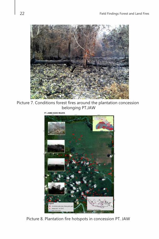
1.2 PT. Jambi Agro Wijaya (PT. JAW) Visiting location of plantation of PT. Jambi Agro Wijaya and based
on information gained from people living close to the company, it is subordinate company of Bakrie Sumatera Plantation located in Sub District of Pauh, District of Sarulangun. The fire was found also close to plantation concession of PT. Jambi Agro Wijaya. When the team found the land, there were smoke and fire which were not extinguished yet and still releasing smokes. The land was peatlands located close to land plantation which was planted with palm oil. Heading to location of the fires, the team utilized access of the company’s road.
22
Field Findings Forest and Land Fires
Picture 7. Conditions forest fires around the plantation concession
belonging PT.JAW
Picture 8. Plantation fire hotspots in concession PT. JAW

in South Sumatera, East Kalimantan, Jambi and Riau
23
1.3 Indo Agroganda Lestari (PT. IAL) It is a subordinate company of Torganda Group, located in Sub
District of Air Hitam District of Sarolangun. It borders with plantation belonging to PT. Era Mitra Agro Lestari. Information gathered by the team from security guards, the plantation belonging to PT.IAL was burnt almost 1.200 hectares or about 70% from the total of the plantation. They admitted that they did not know the origin and the cause of forest fires. When the team was on the location, the fires on the land of plantation were mostly extinguished, but still releasing smokes. However, there was one location of the land which was burnt, but there was no company staying on the location. Then the fire spread easily to other land which was not burnt yet.
Picture 9. Former condition of fire in land concession PT. IAL.
Ordinate point: S 02.10426° E 102.75513°
The picture above was one of locations of land fire of plantation of PT. IAL, there was no company staying on the location in order to prevent fire not to spread. The burnt land was land planted with young palm oil, of about 4 – 5 years of plantation. The condition of the plantation was fulfilled with bush. The worst was the fire spread widely since there was no effort to extinguish the fire.
1.4 PT. Kresna Duta Agrindo (PT. KDA) It is subordinate company of Sinarmas Group, located in District
of Sarolangun. It was presumed that source of fire was from cigarette stub which was accidently thrown away to peatlands. It caused fire and was not easy to extinguish. It was due to the fact that the peatlands

24
Field Findings Forest and Land Fires
were easy to get burnt. The burnt land was peatlands, the burnt palm oil plantation looked very old and there was possibility to replant. When the team arrived there, there was no fire in surrounding area, but there was smoke released from the former fires. There was no body from the company that could be requested for information related to the fire. When the team stayed around the land, there was no facilities and infrastructures to manage and to prevent fires in the land, such as watchtower and other tools. In fact, the land was peatlands easily to get burnt.
Picture 10. Former condition of fire in land concession PT. KDA.
Ordinate point: S 02.15381 E 102.68647
Picture 11. Plantation fire
hotspots in concession PT.
KDA

in South Sumatera, East Kalimantan, Jambi and Riau
25
2. District of Tanjung Jabung Timur 2.1 PT. Kaswari Unggul There are several companies of palm oil plantations located in the
district. One of them is PT. Kaswari Unggul which was the subordinate company of BBIP (Bukit Brisan Indah Prima) Palm Group. PT. Kaswari Unggul is located in Sub District of Dendang and Sub District of Geragai. The fire occurred in one of concession lands belonging to the company. The team visited the hotspot and found the former fire in land belonging To the company. However, the team found difficulties since the difficult access to search further other possible hotspots. Forest and land fires did not occur only in the plantation belonging to the company but also to plantation belonging to people surrounding area. The team found former fire in the plantation belonging to Mr. T who was the local people of the area and did not know the cause of the fire. He could only explain that the fire was from the land of the company and spread to his land.
Picture 12. Former condition fires and canals in the concession
company owned by PT. Kaswari Unggul. Ordinate point: S
01.24868 E 103.96059
In another location, but still under concession of this company, the team found another former fire, which was not far from the location of the previous fire. The previous fire was very broad and still releasing smoke. There were channel built by the company. The team found different view in the location of the former fire. There were several people with agriculture equipment, such as shovel, to search the land. They seemed to do something on the land. When we tried to

26
Field Findings Forest and Land Fires
approach them, they avoided us quickly. The team thought that they were cleaning the land of former fires in order to replant the land.
Picture 13. Some people with agricultural tools (hoes) in the former
fire plantations owned by PT. Kaswari Unggul.
3. District of Muaro Jambi 1. PT. Rahmat Kurniawan Kertaspersada (PT. RKK) There are several palm oil plantations companies in the district.
One of them is PT Ricky Kurniawan Kertapersada (RKK). There was fire on the land of palm oil plantations under the concession of PT. RKK.
It is considered as the suspect of land fire in PT.RKK and the person was the employee of PT.RKK.
Picture 14. Former fires and canals in the concession company PT. RKK
Ordinate point: S 01.69181 E 103.94897
in South Sumatera, East Kalimantan, Jambi and Riau
27
Apart from the burnt land of plantation belonging to the company, plantations belonging to society and managed collectively were burnt also. The team and the society observed the condition of the burnt land. Arriving in the location of the fire, the land was still burnt and releasing thick smoke. There was no maximum effort that could be done by the society due to the lacking of equipment and limited resources. The society did not know where the origin of the fire and how their land could be burnt.
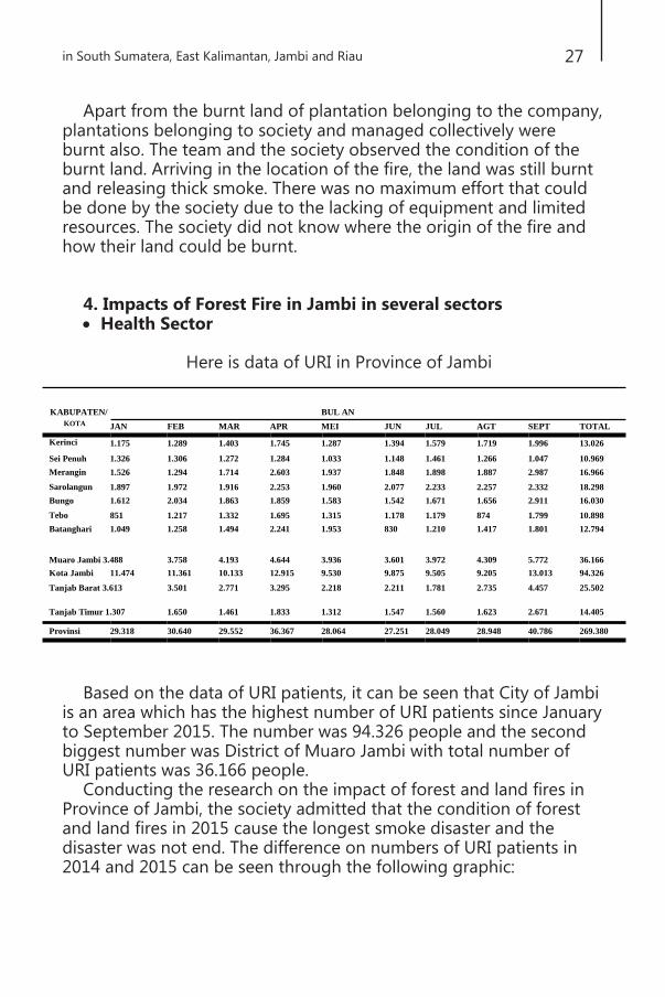
4. Impacts of Forest Fire in Jambi in several sectors Health Sector
Here is data of URI in Province of Jambi
KABUPATEN/
BUL AN
KOTA
Kerinci
Sei Penuh
Merangin
Sarolangun
Bungo
Tebo
Batanghari
JAN
1.175
1.326
1.526
1.897
1.612
851
1.049
FEB
1.289
1.306
1.294
1.972
2.034
1.217
1.258
MAR
1.403
1.272
1.714
1.916
1.863
1.332
1.494
APR
1.745
1.284
2.603
2.253
1.859
1.695
2.241
MEI
1.287
1.033
1.937
1.960
1.583
1.315
1.953
JUN
1.394
1.148
1.848
2.077
1.542
1.178
830
JUL
1.579
1.461
1.898
2.233
1.671
1.179
1.210
AGT
1.719
1.266
1.887
2.257
1.656
874
1.417
SEPT
1.996
1.047
2.987
2.332
2.911
1.799
1.801
TOTAL
13.026
10.969
16.966
18.298
16.030
10.898
12.794
Muaro Jambi 3.488
3.758
4.193
4.644
3.936
3.601
3.972
4.309
5.772
36.166
Kota Jambi 11.474 11.361 10.133 12.915 9.530 9.875 9.505 9.205 13.013 94.326
Tanjab Barat 3.613
Tanjab Timur 1.307
3.501
1.650
2.771
1.461
3.295
1.833
2.218
1.312
2.211
1.547
1.781
1.560
2.735
1.623
4.457
2.671
25.502
14.405
Provinsi 29.318 30.640 29.552 36.367 28.064 27.251 28.049 28.948 40.786 269.380
Based on the data of URI patients, it can be seen that City of Jambi is an area which has the highest number of URI patients since January to September 2015. The number was 94.326 people and the second biggest number was District of Muaro Jambi with total number of URI patients was 36.166 people.
Conducting the research on the impact of forest and land fires in Province of Jambi, the society admitted that the condition of forest and land fires in 2015 cause the longest smoke disaster and the disaster was not end. The difference on numbers of URI patients in 2014 and 2015 can be seen through the following graphic:

28
Field Findings Forest and Land Fires
Graphic on Number of URI patients Year 2014 – 2015 in Province of Jambi
From the graphic above we can see that the number of patients in the similar period of 2014 to 2015 was increasing. It can be concluded that the condition of the lingering forest and land fires cause the smoke disaster as one main factor disturbing the public health.
Based on the discussion with Head of Education Service of City of Jambi, Mr. Saiful H, the smoke disaster threatened health of students, especially elementary school students, kindergarten students of PAUD students. The policy to dismiss the school was based on coordination between Regional Environment Agency and the mayor. Therefore, the mayor could give instructions on days off to head of service and delivered to schools. The policy to dismiss schools was based on information on condition of ISPU, that was when ISPU >300 then all schools must be dismissed. ISPU 99-200 SD (Grade 1-3), kindergarten and PAUD. However, all students except elementary schools (grade 1 – 3), kindergarten and PAUD were obliged to attend school on Mondays and Thursdays until there was another instruction on days off from the government. However, when the condition of ISPU was not dangerous, students attend school as always.

in South Sumatera, East Kalimantan, Jambi and Riau
29
Province of Riau
Analysis dated on 1 to 26 September 2015, there were 1341 hotspots spread in the whole Province of Riau based on the analysis of Hotspot NASA Firm. There were 348 spots in the palm oil plantations and 274 in the concession of forest. From all hotspots occurring in September, 637 of them were on peatlands with the depth between 50 – 800 centimeters, 259 spots were at concession of palm oil plantations, and 105 spots were at concession of industry crops forest, and the rest were at agricultural areas belonging to the society.
Picture 15. Hotspot in areal of PT. Langgam Inti Hibrindo Pelelawan: (Halim/PSW). The burnt areas were about 500 hectare, but media
wrote only about 200 hectare
Picture 16. Hotspot in areal of PT. RAPP (APRIL Group) Pelelawan: (Halim/PSW). The areas burnt were about 200 hectare

District/Municipality Jan Feb Mar Apr May Jun Jul Aug Sep
BENGKALIS 41 277 353 157 37 69 364 38 36
DUMAI 0 12 19 19 4 23 103 6 8
INDRAGIRI HILIR 15 37 17 29 21 52 167 144 167
INDRAGIRI HULU 17 2 0 11 10 53 234 181 363
KAMPAR 4 3 5 15 12 27 107 46 123
KEPULAUAN
MERANTI
4 37 76 16 11 13 36 7 4
KUANTAN SINGINGI 11 1 0 2 0 20 53 14 49
PEKANBARU 0 0 2 0 0 0 7 3 0
PELALAWAN 45 77 82 74 67 185 464 162 496
ROKAN HILIR 0 31 28 10 8 114 359 30 20
ROKAN HULU 1 7 13 1 3 15 45 7 23
SIAK 4 61 37 81 34 49 167 42 52
TOTAL 142 545 632 415 207 620 2106 680 1341
30
Field Findings Forest and Land Fires
Total Hotspots from January to 26 September 2015
Hotspot in personal land at Kampar with coordinate of 0*25’58,2” N – 101*18’31,2” E
Impacts of Forest Fire in Riau in several sectors Health Sector
Forest and land fire brought negative impacts to the live of Riau. Standard Index of Air Pollution in Riau had reached its limit and considered into category of very dangerous within the last month. The highest number was above 500 PM10. The following is the table of impact to public health in Province of Riau dated on 29 June to 28 September 2015.
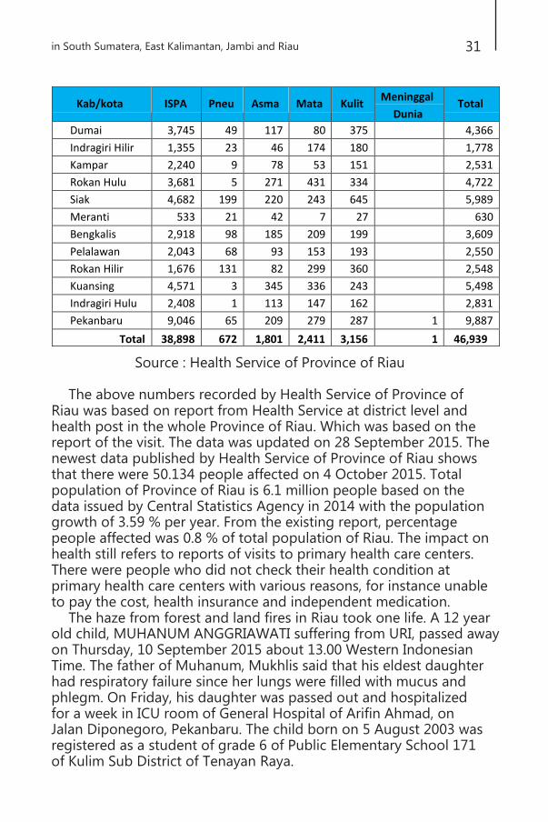
Kab/kota ISPA Pneu Asma Mata Kulit Meninggal
Dunia Total
Dumai 3,745 49 117 80 375 4,366
Indragiri Hilir 1,355 23 46 174 180 1,778
Kampar 2,240 9 78 53 151 2,531
Rokan Hulu 3,681 5 271 431 334 4,722
Siak 4,682 199 220 243 645 5,989
Meranti 533 21 42 7 27 630
Bengkalis 2,918 98 185 209 199 3,609
Pelalawan 2,043 68 93 153 193 2,550
Rokan Hilir 1,676 131 82 299 360 2,548
Kuansing 4,571 3 345 336 243 5,498
Indragiri Hulu 2,408 1 113 147 162 2,831
Pekanbaru 9,046 65 209 279 287 1 9,887
Total 38,898 672 1,801 2,411 3,156 1 46,939
in South Sumatera, East Kalimantan, Jambi and Riau
31
Source : Health Service of Province of Riau
The above numbers recorded by Health Service of Province of Riau was based on report from Health Service at district level and health post in the whole Province of Riau. Which was based on the report of the visit. The data was updated on 28 September 2015. The newest data published by Health Service of Province of Riau shows that there were 50.134 people affected on 4 October 2015. Total population of Province of Riau is 6.1 million people based on the data issued by Central Statistics Agency in 2014 with the population growth of 3.59 % per year. From the existing report, percentage people affected was 0.8 % of total population of Riau. The impact on health still refers to reports of visits to primary health care centers. There were people who did not check their health condition at primary health care centers with various reasons, for instance unable to pay the cost, health insurance and independent medication.
The haze from forest and land fires in Riau took one life. A 12 year old child, MUHANUM ANGGRIAWATI suffering from URI, passed away on Thursday, 10 September 2015 about 13.00 Western Indonesian Time. The father of Muhanum, Mukhlis said that his eldest daughter had respiratory failure since her lungs were filled with mucus and phlegm. On Friday, his daughter was passed out and hospitalized for a week in ICU room of General Hospital of Arifin Ahmad, on Jalan Diponegoro, Pekanbaru. The child born on 5 August 2003 was registered as a student of grade 6 of Public Elementary School 171 of Kulim Sub District of Tenayan Raya.

Tingkatan Jumlah Siswa
TK 30880
SD 795842
SLTP 243572
SLTA 197714
SLB 1772
Total 1269780
32
Field Findings Forest and Land Fires
Education Sector Due to lingering haze in Riau, until Friday, 2 October 2015,
the schools were dismissed in City of Pekanbaru, and it was the 28th days off. The similar condition applied the same to the whole districts/municipality in Province of Riau. It was very devastating for education. Therefore, education authority of Province of Riau took a breakthrough by opening schools for two to three times a week. It was noted that in 2014, there were 1.26 million of students were disadvantaged by the haze. Here is the table of education age in Riau.
Source : Education and culture department of Province Riau
Economy Sector Until now, there was no valid data from Government of Province
of Riau available on the loss. Kamar dagang dan industri (Chamber of Commerce and Industry/KADIN) of Province of Riau estimated the economy loss of Riau due to haze was about 20 billion based on the shrinkage of Gross Domestic Products (GDP) of Riau in amount of 8%. Such forecast was based on the report of loss of 13.000 business unit joining under KADIN of Riau. Whilst there was about 1 million of business unit not joining KADIN of Riau. Whilst Bank of Indonesia of Riau released GDP in 2014 reaching to IDR 679.69 trillion. When there was shrinkage of 8%, then the potential loss would be IDR 54.375 trillion. Such number is 5 times bigger than GDP in 2015 amount of 10.7 trillion and amendment of APBD (regional budget) in amount of 11 trillion and 7 times than regional generated revenue of Riau.
Since 26 August to 21 September 2015, there were 408 disturbed scheduled flights. Transportation Service recorded 201 delayed flights, 26 diverted flights, 4 returning to original airport, and 178 canceled flights. This problem was due to a very short visibility of 1000 – 50 meters. Association of National Company of Freight and Delivery
in South Sumatera, East Kalimantan, Jambi and Riau
33
Cargo of Indonesia (Asosiasi Perusahaan Nasional Pengiriman dan Pengantaran Barang Indonesia), Riau performed decreased productivity of 80% due to delivery cargo did not go as scheduled. The entrepreneurs Small Medium Enterprises (Usaha Mikro Kecil dan Menengah/UMKM) of food and beverages experienced decreasing turnover of their business up to 90% (minutes meeting of FGD on Identification of Impacts and Business Solution Due to Haze for Entrepreneurs in Province of Riau, 17 September 2015). Besides, the buying power of society was decreased in Province of Riau. In tradition markets, the decreased buying power reached to 70% based on the survey in several traditional markets in Pekanbaru.
Forest fires happened each year in Province of Riau. It does not make the regional government realize to provide more attention to it. It can be seen from the number of budgeted allocation of APBD for program on management of forest and land fires. APBD of Province of Riau increases significantly each year since 2009 – 2013. It is recorded that expenditure realization of 2009 was in amount of IDR 3.7 trillion and increased significantly in 2013 in amount of IDR 8.4 trillion. However, the increased regional expenditure did not contribute significantly to allocated budget on environmental conservation. Therefore, it is normal when problems on forest fires in Province of Riau will repeat continuously and the local government is not able to handle it. Even though, there is allocated budget for each year on program of management of forest and land fires in APBD Province of Riau. However, the value is too small. In 2009 – 2013, Forestry Service of Province of Riau was allocated the budget in amount of IDR 6,065,625,000 with realization (2009 – 2013) in amount of IDR 3,916.006.050,- Whilst in Environment Agency of Province of Riau, 2009 – 2013 was allocated in amount of IDR 12,549,594,050.00 and was realized in amount of IDR 7,866,929,140.00. When it is calculated in percentage, the numbers of APBD Riau in 2009 – 2013 was IDR 28,642,594,737,572.80 Therefore, allocated budget for the annual disaster was only 0.47%. The allocated budget was utilized for coordination, socialization, and purchasing tools (equipment) for Forestry Service. Whilst in Environment Agency, such budget is used for socialization, coordination, training and education.

34
Foto: Save Our Borneo (SOB) and Sawit Watch, 2015
Perumahan Bogor Baru Taman
Jl. Cisangkui Blok B6/1
Bogor Tengah, Bogor
Jawa Barat – INDONESIA
Phone : +62-251- 8352171
Field Findings Forest and Land Fires
Fax
: +62-251- 8352047
Twitter : @sawit_watch
Website: www.sawitwatch.or.id