fews et - · pdf file22.08.2014 · famine earl warnin sstems network fews et loal...
TRANSCRIPT
FAMINE EARLY WARNING SYSTEMS NETWORK
FEWS NETGlobal Weather Hazards Summary
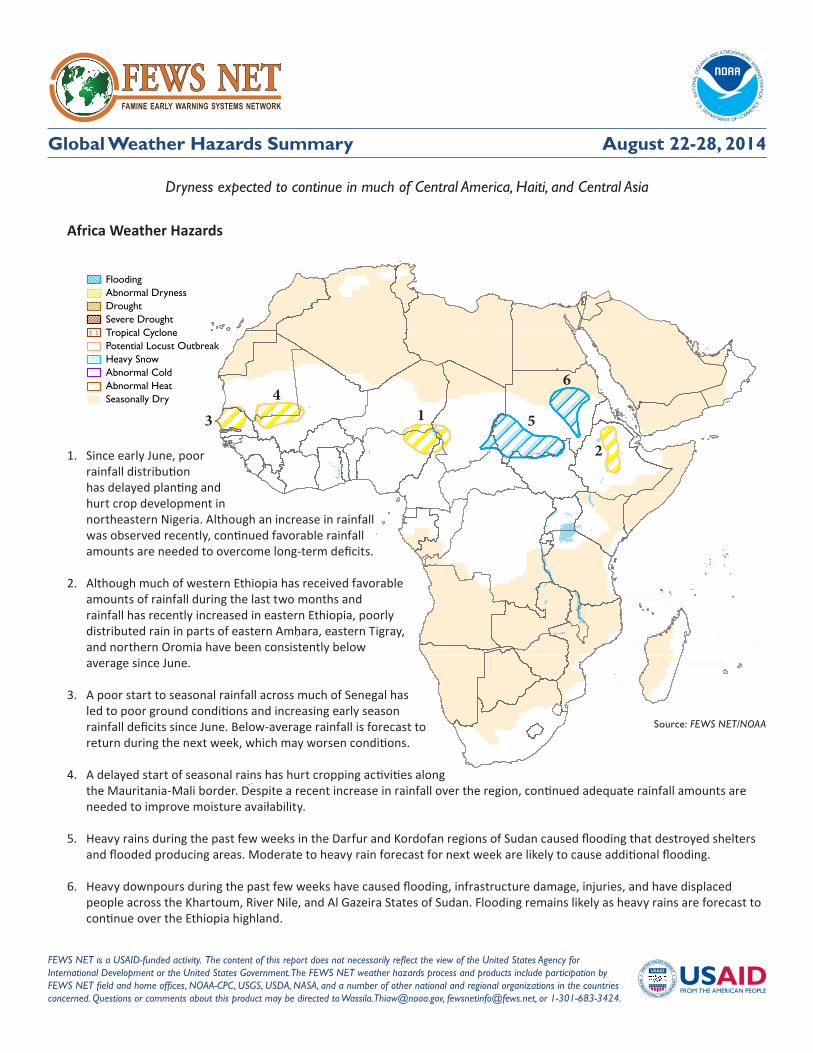
Africa Weather Hazards
FEWS NET is a USAID-funded activity. The content of this report does not necessarily reflect the view of the United States Agency for International Development or the United States Government. The FEWS NET weather hazards process and products include participation by FEWS NET field and home offices, NOAA-CPC, USGS, USDA, NASA, and a number of other national and regional organizations in the countries concerned. Questions or comments about this product may be directed to [email protected], [email protected], or 1-301-683-3424.
Source: FEWS NET/NOAA
FloodingAbnormal DrynessDroughtSevere DroughtTropical CyclonePotential Locust OutbreakHeavy SnowAbnormal ColdAbnormal HeatSeasonally Dry
August 22-28, 2014
Dryness expected to continue in much of Central America, Haiti, and Central Asia
1
1. Since early June, poor rainfall distribution has delayed planting and hurt crop development in northeastern Nigeria. Although an increase in rainfall was observed recently, continued favorable rainfall amounts are needed to overcome long-term deficits.
2. Although much of western Ethiopia has received favorable amounts of rainfall during the last two months and rainfall has recently increased in eastern Ethiopia, poorly distributed rain in parts of eastern Amhara, eastern Tigray, and northern Oromia have been consistently below average since June.
3. A poor start to seasonal rainfall across much of Senegal has led to poor ground conditions and increasing early season rainfall deficits since June. Below-average rainfall is forecast to return during the next week, which may worsen conditions.
4. A delayed start of seasonal rains has hurt cropping activities along the Mauritania-Mali border. Despite a recent increase in rainfall over the region, continued adequate rainfall amounts are needed to improve moisture availability.
5. Heavy rains during the past few weeks in the Darfur and Kordofan regions of Sudan caused flooding that destroyed shelters and flooded producing areas. Moderate to heavy rain forecast for next week are likely to cause additional flooding.
6. Heavy downpours during the past few weeks have caused flooding, infrastructure damage, injuries, and have displaced people across the Khartoum, River Nile, and Al Gazeira States of Sudan. Flooding remains likely as heavy rains are forecast to continue over the Ethiopia highland.
2
34
5
6

Famine Early Warning Systems Network 2
Weather Hazards Summary
Latin America and the Caribbean Weather Hazards
Central Asia Weather Hazards
No HazardsPosted for
Central America
Source: FEWS NET/NOAA
FloodingAbnormal DrynessDroughtSevere DroughtTropical CyclonePotential Locust OutbreakHeavy SnowAbnormal ColdAbnormal Heat
Source: FEWS NET/NOAA
FloodingAbnormal DrynessDroughtSevere DroughtTropical CyclonePotential Locust OutbreakHeavy SnowAbnormal ColdAbnormal Heat
August 22-28, 2014
1. Poor rainfall distribution since early May has led to abnormal dryness and drought over southern and northeastern Hispaniola, with the worst conditions in southeastern Dominican Republic. Dam-supplying rivers are below their normal levels, which has led to water restrictions and occasional power outages in the Dominican Republic.
2. Below-average and poorly distributed rainfall since late June across central Guatemala, southern Honduras, El Salvador, and western Nicaragua is likely to hurt development of Primera crops.
3. Long dry spells and below-average rain since March have led to substantial seasonal rainfall deficits and poor ground conditions in southeastern Honduras, west-central Nicaragua, and northern Costa Rica. Poorly distributed Primera rainfall and acute dryness during mid-June has also caused crop failure in eastern El Salvador, southern Honduras, and eastern Guatemala.
1. Below-average rainfall since May has resulted in drought conditions in northwest Kazakhstan, where dry weather continued during the last week.
2. Poorly distributed rainfall since May has led to growing moisture deficits and low soil moisture in southeastern Kazakhstan.
3. Abnormal heat is expected in parts of Kazakhstan, where maximum average temperatures of 35-40°C are about 10°C higher than normal.
TemperaturesTemperatures averaged 3-6°C above normal across western Kazakhstan last week, where maximum tempeartures reached 36°C. Otherwise, seasonal temperatures prevailed across Central Asia. During the next week, temperatures are expected to average well above normal (10°C or more) across much of Kazakhstan.
PrecipitationDue to below-average rainfall since May has resulted in drought conditions across parts of northwest Kazakhstan where dry weather persisted this past week. Meanwhile, widespread rain (locally more than 50 mm) fell across north-central and northeastern Kazakhstan. Since this rainfall nearly eliminated precipitation deficits across northeastern Kazakhstan, the abnormal dryness polygon has been removed from this region. During the next week, little or no precipitation is expected across Central Asia. Monsoon rainfall is expected to be lighter across northern Pakistan.
1
3
1
12
3
2
Famine Early Warning Systems Network 3
Weather Hazards Summary
Africa
Increased rains fall over West Africa
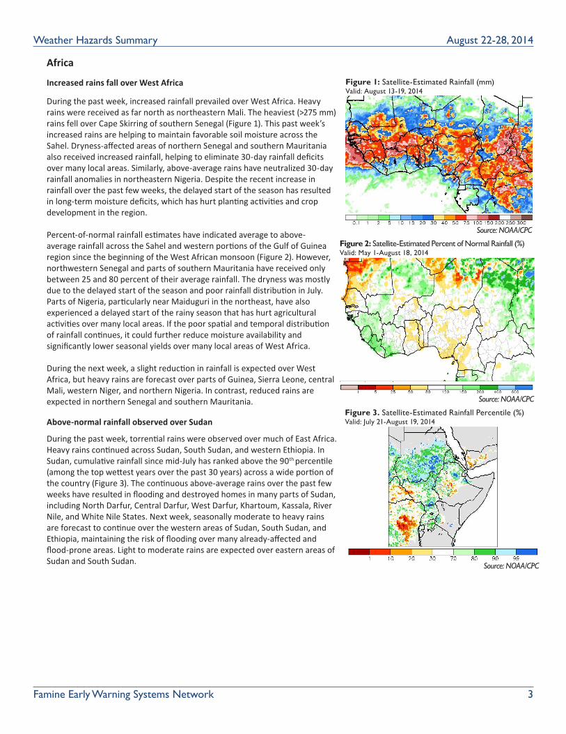
During the past week, increased rainfall prevailed over West Africa. Heavy rains were received as far north as northeastern Mali. The heaviest (>275 mm) rains fell over Cape Skirring of southern Senegal (Figure 1). This past week’s increased rains are helping to maintain favorable soil moisture across the Sahel. Dryness-affected areas of northern Senegal and southern Mauritania also received increased rainfall, helping to eliminate 30-day rainfall deficits over many local areas. Similarly, above-average rains have neutralized 30-day rainfall anomalies in northeastern Nigeria. Despite the recent increase in rainfall over the past few weeks, the delayed start of the season has resulted in long-term moisture deficits, which has hurt planting activities and crop development in the region.
Percent-of-normal rainfall estimates have indicated average to above-average rainfall across the Sahel and western portions of the Gulf of Guinea region since the beginning of the West African monsoon (Figure 2). However, northwestern Senegal and parts of southern Mauritania have received only between 25 and 80 percent of their average rainfall. The dryness was mostly due to the delayed start of the season and poor rainfall distribution in July. Parts of Nigeria, particularly near Maiduguri in the northeast, have also experienced a delayed start of the rainy season that has hurt agricultural activities over many local areas. If the poor spatial and temporal distribution of rainfall continues, it could further reduce moisture availability and significantly lower seasonal yields over many local areas of West Africa.
During the next week, a slight reduction in rainfall is expected over West Africa, but heavy rains are forecast over parts of Guinea, Sierra Leone, central Mali, western Niger, and northern Nigeria. In contrast, reduced rains are expected in northern Senegal and southern Mauritania.
Above-normal rainfall observed over Sudan
During the past week, torrential rains were observed over much of East Africa. Heavy rains continued across Sudan, South Sudan, and western Ethiopia. In Sudan, cumulative rainfall since mid-July has ranked above the 90th percentile (among the top wettest years over the past 30 years) across a wide portion of the country (Figure 3). The continuous above-average rains over the past few weeks have resulted in flooding and destroyed homes in many parts of Sudan, including North Darfur, Central Darfur, West Darfur, Khartoum, Kassala, River Nile, and White Nile States. Next week, seasonally moderate to heavy rains are forecast to continue over the western areas of Sudan, South Sudan, and Ethiopia, maintaining the risk of flooding over many already-affected and flood-prone areas. Light to moderate rains are expected over eastern areas of Sudan and South Sudan.
August 22-28, 2014
Figure 1: Satellite-Estimated Rainfall (mm)Valid: August 13-19, 2014
Figure 2: Satellite-Estimated Percent of Normal Rainfall (%) Valid: May 1-August 18, 2014
Figure 3. Satellite-Estimated Rainfall Percentile (%)Valid: July 21-August 19, 2014
Source: NOAA/CPC
Source: NOAA/CPC
Source: NOAA/CPC
Note: The hazards outlook map on page 1 is based on current weather/climate information and short and medium range weather forecasts (up to 1 week). It assesses their potential impact on crop and pasture conditions. Shaded polygons are added in areas where anomalous conditions have been observed. The boundaries of these polygons are only approximate at this continental scale. This product does not reflect long range seasonal climate forecasts or indicate current or projected food security conditions. Questions or comments about this product may be directed to [email protected] or 1-301-683-3424.
Increased rains observed in West Africa.
During the past week, increased rains prevailed over West Africa. The rainbelt ondulated across the subregion from The Gambia, southern Senegal, Guinea Bissau, Guinea Conakry, Mali, Burkina Faso, Niger, northern Nigeria, to Chad, and CAR (Figure 1). Heavy rains were received as far north as northeastern Mali. The heaviest (> 275 mm) rains were observed over Cape Skiring of southern Senegal. This past week’s enhanced rains have contributed to maintain favorable soil moisture across the Sahel. Enhanced rains were also registered over the dryness-affected areas of northern Senegal and southern Mauritania. This has helped eliminate thirty-day rainfall deficits over many local areas. Similarly, heavy and above-average rains have neutralized thirty-day rainfall anomalies in northeastern Nigeria. However, despite the recent increase in rainfall over the past few weeks, the delayed start of the season has resulted in long-term moisture deficits, which has negatively impacted planting activities and crop development in the region.
Percent of normal rainfall since the beginning of the West African monsoon has indicated average to above-average rainfall across the Sahel and western portions of the Gulf of Guinea region (Figure 2). However, northwestern Senegal and parts of southern Mauritania have received only between 25 and 80 percent of their average rainfall. The dryness was mostly attributed to the delayed start of the season and poor rainfall distribution in July. Parts of Nigeria, particularly the Maiduguri in the northeast, have also experienced a delayed start of the rainy season, which had already negatively affected agricultural activities over many local areas. If the uneven spatial and temporal distribution of rainfall continues, it could reduce moisture availability further and significantly lower seasonal yields over many local areas of West Africa.
During the next week, a slight reduction in rainfall is expected over West Africa. Though, heavy rains are forecast over parts of Guinea Conakry, Sierra Leone, central Mali, western Niger, and northern Nigeria. In contrast, reduced rains are expected in northern Senegal and southern Mauritania.
Atypical wetness observed over Sudan.
During the past week, torrential rains were observed over much of Eastern Africa. Heavy rains continued across Sudan, South Sudan, and western Ethiopia. Over Sudan, the season has been abnormally wet as cumulative rainfall since mid-July has ranked over the 90th percentile (among the top wettest years over the past thirty years) across a wide portion of the country (Figure 3). The continuous above-average rains over the past few weeks have resulted in flooding, destroyed homes, and thousands of affected people in many parts of Sudan, including the North Darfur, Central Darfur, West Darfur, Khartoum, Kassala, River Nile, and White Nile. For next week, seasonal, moderate to heavy rains are forecast to continue over the Darfur of western Sudan, western South Sudan, and western Ethiopia. This, therefore, maintains the risks for flooding over many already-affected and flood-prone areas. Light to moderate rains are expected over eastern South Sudan and eastern Sudan.
Satellite Estimated Rainfall (mm) Valid: August 13 – August 19, 2014
Figure 1: NOAA/CPC
Satellite Estimated Percent of Normal Rainfall (%) Valid: May 1 – August 18, 2014
Figure 2: NOAA/CPC
Satellite Estimated Rainfall Percentile Valid: July 21 – August 19, 2014
Figure 3: NOAA/CPC
Note: The hazards outlook map on page 1 is based on current weather/climate information and short and medium range weather forecasts (up to 1 week). It assesses their potential impact on crop and pasture conditions. Shaded polygons are added in areas where anomalous conditions have been observed. The boundaries of these polygons are only approximate at this continental scale. This product does not reflect long range seasonal climate forecasts or indicate current or projected food security conditions. Questions or comments about this product may be directed to [email protected] or 1-301-683-3424.
Increased rains observed in West Africa.
During the past week, increased rains prevailed over West Africa. The rainbelt ondulated across the subregion from The Gambia, southern Senegal, Guinea Bissau, Guinea Conakry, Mali, Burkina Faso, Niger, northern Nigeria, to Chad, and CAR (Figure 1). Heavy rains were received as far north as northeastern Mali. The heaviest (> 275 mm) rains were observed over Cape Skiring of southern Senegal. This past week’s enhanced rains have contributed to maintain favorable soil moisture across the Sahel. Enhanced rains were also registered over the dryness-affected areas of northern Senegal and southern Mauritania. This has helped eliminate thirty-day rainfall deficits over many local areas. Similarly, heavy and above-average rains have neutralized thirty-day rainfall anomalies in northeastern Nigeria. However, despite the recent increase in rainfall over the past few weeks, the delayed start of the season has resulted in long-term moisture deficits, which has negatively impacted planting activities and crop development in the region.
Percent of normal rainfall since the beginning of the West African monsoon has indicated average to above-average rainfall across the Sahel and western portions of the Gulf of Guinea region (Figure 2). However, northwestern Senegal and parts of southern Mauritania have received only between 25 and 80 percent of their average rainfall. The dryness was mostly attributed to the delayed start of the season and poor rainfall distribution in July. Parts of Nigeria, particularly the Maiduguri in the northeast, have also experienced a delayed start of the rainy season, which had already negatively affected agricultural activities over many local areas. If the uneven spatial and temporal distribution of rainfall continues, it could reduce moisture availability further and significantly lower seasonal yields over many local areas of West Africa.
During the next week, a slight reduction in rainfall is expected over West Africa. Though, heavy rains are forecast over parts of Guinea Conakry, Sierra Leone, central Mali, western Niger, and northern Nigeria. In contrast, reduced rains are expected in northern Senegal and southern Mauritania.
Atypical wetness observed over Sudan.
During the past week, torrential rains were observed over much of Eastern Africa. Heavy rains continued across Sudan, South Sudan, and western Ethiopia. Over Sudan, the season has been abnormally wet as cumulative rainfall since mid-July has ranked over the 90th percentile (among the top wettest years over the past thirty years) across a wide portion of the country (Figure 3). The continuous above-average rains over the past few weeks have resulted in flooding, destroyed homes, and thousands of affected people in many parts of Sudan, including the North Darfur, Central Darfur, West Darfur, Khartoum, Kassala, River Nile, and White Nile. For next week, seasonal, moderate to heavy rains are forecast to continue over the Darfur of western Sudan, western South Sudan, and western Ethiopia. This, therefore, maintains the risks for flooding over many already-affected and flood-prone areas. Light to moderate rains are expected over eastern South Sudan and eastern Sudan.
Satellite Estimated Rainfall (mm) Valid: August 13 – August 19, 2014
Figure 1: NOAA/CPC
Satellite Estimated Percent of Normal Rainfall (%) Valid: May 1 – August 18, 2014
Figure 2: NOAA/CPC
Satellite Estimated Rainfall Percentile Valid: July 21 – August 19, 2014
Figure 3: NOAA/CPC Note: The hazards outlook map on page 1 is based on current weather/climate information and short and medium range weather forecasts (up to 1 week). It assesses their potential impact on crop and pasture conditions. Shaded polygons are added in areas where anomalous conditions have been observed. The boundaries of these polygons are only approximate at this continental scale. This product does not reflect long range seasonal climate forecasts or indicate current or projected food security conditions. Questions or comments about this product may be directed to [email protected] or 1-301-683-3424.
Increased rains observed in West Africa.
During the past week, increased rains prevailed over West Africa. The rainbelt ondulated across the subregion from The Gambia, southern Senegal, Guinea Bissau, Guinea Conakry, Mali, Burkina Faso, Niger, northern Nigeria, to Chad, and CAR (Figure 1). Heavy rains were received as far north as northeastern Mali. The heaviest (> 275 mm) rains were observed over Cape Skiring of southern Senegal. This past week’s enhanced rains have contributed to maintain favorable soil moisture across the Sahel. Enhanced rains were also registered over the dryness-affected areas of northern Senegal and southern Mauritania. This has helped eliminate thirty-day rainfall deficits over many local areas. Similarly, heavy and above-average rains have neutralized thirty-day rainfall anomalies in northeastern Nigeria. However, despite the recent increase in rainfall over the past few weeks, the delayed start of the season has resulted in long-term moisture deficits, which has negatively impacted planting activities and crop development in the region.
Percent of normal rainfall since the beginning of the West African monsoon has indicated average to above-average rainfall across the Sahel and western portions of the Gulf of Guinea region (Figure 2). However, northwestern Senegal and parts of southern Mauritania have received only between 25 and 80 percent of their average rainfall. The dryness was mostly attributed to the delayed start of the season and poor rainfall distribution in July. Parts of Nigeria, particularly the Maiduguri in the northeast, have also experienced a delayed start of the rainy season, which had already negatively affected agricultural activities over many local areas. If the uneven spatial and temporal distribution of rainfall continues, it could reduce moisture availability further and significantly lower seasonal yields over many local areas of West Africa.
During the next week, a slight reduction in rainfall is expected over West Africa. Though, heavy rains are forecast over parts of Guinea Conakry, Sierra Leone, central Mali, western Niger, and northern Nigeria. In contrast, reduced rains are expected in northern Senegal and southern Mauritania.
Atypical wetness observed over Sudan.
During the past week, torrential rains were observed over much of Eastern Africa. Heavy rains continued across Sudan, South Sudan, and western Ethiopia. Over Sudan, the season has been abnormally wet as cumulative rainfall since mid-July has ranked over the 90th percentile (among the top wettest years over the past thirty years) across a wide portion of the country (Figure 3). The continuous above-average rains over the past few weeks have resulted in flooding, destroyed homes, and thousands of affected people in many parts of Sudan, including the North Darfur, Central Darfur, West Darfur, Khartoum, Kassala, River Nile, and White Nile. For next week, seasonal, moderate to heavy rains are forecast to continue over the Darfur of western Sudan, western South Sudan, and western Ethiopia. This, therefore, maintains the risks for flooding over many already-affected and flood-prone areas. Light to moderate rains are expected over eastern South Sudan and eastern Sudan.
Satellite Estimated Rainfall (mm) Valid: August 13 – August 19, 2014
Figure 1: NOAA/CPC
Satellite Estimated Percent of Normal Rainfall (%) Valid: May 1 – August 18, 2014
Figure 2: NOAA/CPC
Satellite Estimated Rainfall Percentile Valid: July 21 – August 19, 2014
Figure 3: NOAA/CPC

Famine Early Warning Systems Network 4
Weather Hazards Summary
ABOUT WEATHER HAZARDSHazard maps are based on current weather/climate information, short and medium range weather forecasts (up to 1 week) and their potential impact on crop and pasture conditions. Shaded polygons are added in areas where anomalous conditions have been observed. The boundaries of these polygons are only approximate at this continental scale. This product does not reflect long range seasonal climate forecasts or indicate current or projected food security conditions.
Latin America and the Caribbean
Increased rainfall in mid-August continue to replenish ground moisture
During the last week, heavy rain fell along the Atlantic side of Central America, with the highest weekly accumulations (>100mm) in northern Guatemala, northern Honduras, and eastern Nicaragua. Lighter, yet well-distributed rain (10-25mm) fell across inland Central America, bringing some relief to several areas affected by abnormal dryness and seasonal drought in central Guatemala, southern Honduras, and central Nicaragua. On the Pacific side, increased rains also fell across southern Guatemala and parts of El Salvador and Costa Rica. Following very poor rains in July, increased rains since the beginning of August have improved both short-term and long-term moisture deficits in several regions of Guatemala, El Salvador, Honduras, Nicaragua and Costa Rica. However, both local rain gauges and satellite-derived rainfall estimates still show large moisture deficits ranging between 10 to 50 percent of normal rainfall since May across the Pacific side of Central America. Much of this dryness has already resulted in failed and wilted Primera crops in many local areas.
During the next week, forecasts suggest decreased amounts of rain will fall across much of Guatemala, Honduras, and El Salvador, with seasonal rainfall amounts limited to the southern Central America region. Despite the recent moisture recovery, the return of below-average precipitation is likely expected to strengthen seasonal moisture deficits by the end of August.
Increased rains received in central Haiti, with worsening dryness in the Dominican Republic
During the last week, rainfall increased throughout many local areas of the island. The highest amounts (>50 mm) fell in central Haiti, with more moderate and well-distributed rainfall in central areas of the Dominican Republic. Since the beginning of August, seasonal rainfall has generally been average throughout central and northern Hispaniola, but average to below-average soil moisture persists in the south. Despite some improved rains, cumulative seasonal rainfall continues to be 50 to 80 percent of normal throughout both the Dominican Republic and Haiti, with deeper moisture deficits (<50 percent of normal) along the southern coastline. This long-term dryness is due to a delayed start of rains and erratic seasonal rainfall, which is expected to negatively affect local water resources and developing cropping activities. During the next week, rainfall forecasts suggest a continuation of moderate to locally heavy rains over Hispaniola, with the potential for the highest amounts over southern Haiti and western Dominican Republic. These rains are expected to help alleviate dryness in many areas. However, more rainfall is needed during the next several weeks to overcome moisture deficits southern and southeastern Hispaniola.
Source: NOAA/CPC
August 22-28, 2014
Figure 1: Seven-Day Total Rainfall Forecast (mm)Valid: August 20-27, 2014
Questions or comments about this product may be directed to [email protected] or 1-301-683-3424.
Increased rainfall during middle of August continues to replenish ground conditions. During the last week, heavy amounts of precipitation were mostly received along the Atlantic side of Central America, as the highest weekly accumulations (>100mm) were felt across much of northern Guatemala, northern Honduras, and eastern Nicaragua. Lesser, but well-distributed weekly amounts (10-25mm) were received across many interior areas of Central America, bringing some relief to several areas affected by abnormal dryness and seasonal drought in central Guatemala, southern Honduras, and central Nicaragua. On the Pacific side, enhanced rains were also received across southern Guatemala, as well as, throughout parts of El Salvador and Costa Rica. Following very poor rains in July, increased rains since the beginning of August has improved both short-term and long-term moisture deficits that have already affected several regions in Guatemala, El Salvador, Honduras, Nicaragua and Costa Rica. However, both local rain gauges and satellite estimated rainfall anomalies since the beginning of May still show large moisture deficits ranging between 10 to 50 percent of normal across the Pacific side of Central America. Much of this dryness has already resulted in failed and wilted Primera crops over many local areas. During the next seven days, model rainfall forecasts indicate a fairly broad scale suppression of rainfall across much of Guatemala, Honduras and El Salvador, with most of seasonable rainfall limited to the southern Central America region. Despite the recent moisture recovery, the return of below-average precipitation is likely expected to strengthen seasonal moisture deficits by the end of August.
Seven-Day Total Rainfall Forecast (mm) August 20 – August 27, 2014
Figure 1: Source NOAA / CPC