federal facilities remedial site inspection (si) summary guide
TRANSCRIPT

FEDERAL FACILITIES REMEDIAL SITEINSPECTION SUMMARY GUIDE
JULY 21, 2005
Environmental Protection AgencyOffice of Enforcement and Compliance Assurance,
Federal Facilities Enforcement Office
And
Office of Solid Waste and Emergency Response, Office of Superfund Remediation and Technology Innovation
And
Office of Solid Waste and Emergency Response,Federal Facilities Restoration and Reuse Office
Ariel Rios Building1200 Pennsylvania Avenue, N.W.
Washington, DC 20460

This page intentionally left blank

Federal Facilities Remedial Site Inspection Summary Guide July 21, 2005
-i-
TABLE OF CONTENTS
Purpose . . . . . . . . . . . . . . . . . . . . . . . . . . . . . . . . . . . . . . . . . . . . . . . . . . . . . . . . . . . . . . . . . . . . . . . . . . . 1
Core SI Data Elements. . . . . . . . . . . . . . . . . . . . . . . . . . . . . . . . . . . . . . . . . . . . . . . . . . . . . . . . . . . . . . . . 3Analytical Data Quality Needs . . . . . . . . . . . . . . . . . . . . . . . . . . . . . . . . . . . . . . . . . . . . . . . . . . . . . . 3Site and Source Characterization . . . . . . . . . . . . . . . . . . . . . . . . . . . . . . . . . . . . . . . . . . . . . . . . . . . . . 4Ground Water Migration Pathway . . . . . . . . . . . . . . . . . . . . . . . . . . . . . . . . . . . . . . . . . . . . . . . . . . . 7
Release to Groundwater . . . . . . . . . . . . . . . . . . . . . . . . . . . . . . . . . . . . . . . . . . . . . . . . . . . . . . . . 7Ground Water Targets . . . . . . . . . . . . . . . . . . . . . . . . . . . . . . . . . . . . . . . . . . . . . . . . . . . . . . . . . 8
Surface Water Migration Pathway . . . . . . . . . . . . . . . . . . . . . . . . . . . . . . . . . . . . . . . . . . . . . . . . . . 10Release to Surface Water . . . . . . . . . . . . . . . . . . . . . . . . . . . . . . . . . . . . . . . . . . . . . . . . . . . . . . 10Surface Water Targets . . . . . . . . . . . . . . . . . . . . . . . . . . . . . . . . . . . . . . . . . . . . . . . . . . . . . . . . 12
Soil Exposure Pathway . . . . . . . . . . . . . . . . . . . . . . . . . . . . . . . . . . . . . . . . . . . . . . . . . . . . . . . . . . . 14Soil Likelihood of Exposure . . . . . . . . . . . . . . . . . . . . . . . . . . . . . . . . . . . . . . . . . . . . . . . . . . . . 14Soil Exposure Targets . . . . . . . . . . . . . . . . . . . . . . . . . . . . . . . . . . . . . . . . . . . . . . . . . . . . . . . . . 15
Air Migration Pathway . . . . . . . . . . . . . . . . . . . . . . . . . . . . . . . . . . . . . . . . . . . . . . . . . . . . . . . . . . . 16Release to Air . . . . . . . . . . . . . . . . . . . . . . . . . . . . . . . . . . . . . . . . . . . . . . . . . . . . . . . . . . . . . . . 16Air Targets . . . . . . . . . . . . . . . . . . . . . . . . . . . . . . . . . . . . . . . . . . . . . . . . . . . . . . . . . . . . . . . . . 17
Radionuclides . . . . . . . . . . . . . . . . . . . . . . . . . . . . . . . . . . . . . . . . . . . . . . . . . . . . . . . . . . . . . . . . . . 18
SI Narrative Report Requirements . . . . . . . . . . . . . . . . . . . . . . . . . . . . . . . . . . . . . . . . . . . . . . . . . . . 20Sample Outline for a SI Narrative Report . . . . . . . . . . . . . . . . . . . . . . . . . . . . . . . . . . . . . . . . . . . . . 20
Appendix A: PA & SI Federal Facility Summary Guide (Information Supplement)
Appendix B: SI Federal Facility Summary Guide (Sample of Completion Checklists)


Federal Facilities Remedial Site Inspection Summary Guide July 21, 2005
1 EPA requires that all environmental data used in decision making be supported by an approved Quality AssuranceProject Plan. This requirement is defined in EPA Order 5360.1 A2 (EPA 2000), Policy and Program Requirements for theMandatory Agency-wide Quality System, for EPA organizations. Non-EPA organizations funded by EPA are required to developa QA Project Plan through:• 48 CFR 46, for contractors;
• 40 CFR 30, 31, and 35 for assistance agreement recipients; and-1-
PURPOSE
The purpose of this Federal Facilities Remedial Site Inspection Summary Guide is to assist Federal agenciesconducting Remedial Site Inspections (SIs) to obtain sufficient information under the ComprehensiveEnvironmental Response, Compensation, and Liability Act (CERCLA) to meet the requirements outlined inthe National Contingency Plan (NCP). This Summary Guide identifies data items that should be includedin a SI and in the SI report that is required to be provided to the US EPA. Following this guide shouldimprove the overall quality of the information provided to EPA Regional programs and aid EPA’s review ofthe information provided. This guide highlights elements from EPA’s previous 1992 SI guidance, Guidancefor Performing Site Inspections Under CERCLA. This guide also provides an update on Quality Assurancechanges that have occurred since the publication of the original guidance in 1992.
This Guide highlights certain data and reporting parameters for conducting a SI at Federal facilities. Datafor the following four core elements of an SI are discussed: Analytical Data Quality, Site and SourceCharacterization, Release(s) of Hazardous Substance(s) or pollutants or contaminants to migration/exposurepathways (ground water, surface water, soil, and air), and associated targets of concern. Also included is abrief discussion on SIs involving radioactive substances (or radionuclides). Sample Completion Checklistshave been included for the core data elements. These Checklists identify recommended data elements for SIsand can be utilized as effective data collection tools. Following this Guide should improve the overall qualityof data collected or developed during the remedial SI process.
BACKGROUND
The National Contingency Plan (NCP) requirements for a SI can be found at 40 CFR Section 300.420 (c).As described there, the SI should build off information collected during the Preliminary Assessment (PA),and has four goals: develop information to potentially eliminate a release from further consideration becauseit is determined that it poses no significant threat to human health or the environment; determine the potentialneed for a removal action; collect or develop data to evaluate the release for the Hazard Ranking System(HRS); and collect data in addition to that needed for the HRS, as appropriate, to better characterize therelease for more effective and rapid initiation of a Remedial Investigation/Feasibility Study (RI/FS). Thesegoals typically require the federal agency to collect and analyze waste and environmental samples to identifythe contaminants present, determine whether hazardous substances, pollutants, or contaminants are beingreleased to the environment, and determine whether the releases have or may affect specific human healthor environmental targets. Typically, to develop sufficient information, the SI may include:
• Review of the PA including any available analytical data developed during the PA• Developing a history of the facility’s operations including waste handling• Site reconnaissance, field observations and measurements• Development of sampling and analysis plans, including a Quality Assurance Project Plan (QAPP)1

Federal Facilities Remedial Site Inspection Summary Guide July 21, 2005
• other mechanisms, such as consent agreements in enforcement actions.In addition, the National Oil and Hazardous Substances Pollution Contingency Plan (NCP) (40 CFR Parts 300-399) requiresQAPPs according to §300.415(b)(4) for non-time critical removals and §300.420(c)(iv)(2, 3, and 4) for SIs. Also, 7.1.g of theUniform Federal Policy for Implementing Environmental Quality Systems requires project specific QAPPs that are described in7.2. EPA 505-B-04-900, Uniform Federal Policy for Quality Assurance Project Plans is a good source of guidance on QAPPdevelopment.§120(a0(2) of CERCLA provides that all guidelines, rules, regulations, and criteria for Preliminary Assessments, SiteInspections, National Priorities List (NPL) listing, and remedial actions are applicable to Federal facilities...”
-2-
• Sample collection and evaluation of all data• photo documentation, as appropriate• preparation of SI report
If the remedial SI indicates that a CERCLA removal action may be appropriate, the federal agency shouldthen initiate a removal site evaluation as called for under the NCP (300.410).
At the completion of the remedial SI, there is a requirement to develop a Remedial SI report (see NCP:300.420(c)(5)). The Remedial SI report should include the following:
• A description/history/nature of waste handling• A description of known contaminants• A description of pathways of migration of contaminants• An identification and description of human and environmental targets, and• A recommendation on whether further action is warranted
This Report should summarize what is known about the site, what is assumed or inferred, the activitiesconducted during the SI, all researched information, findings of the field investigation, and particularly thecontamination associated with the site and migration pathways. The Remedial SI Report, as appropriate,should be accompanied by a photo documentation log and other pertinent information such as a sampling log,other reference materials, including any new analytical data, as described in the Guidance for Performing SiteInspections Under CERCLA, 1992.
Following the completion of the PA/SI for a release at a Federal facility, EPA is required under CERCLAto determine whether the release qualifies for possible inclusion on the CERCLA National Priorities List(NPL) or whether the release can be undertaken by another authority (see CERCLA 120(d)(2)(B)). Shoulda release not qualify for the NPL, a response action still may be required and undertaken by a federal agencyunder CERCLA or some other authority.
CORE REMEDIAL SI DATA ELEMENTS

Federal Facilities Remedial Site Inspection Summary Guide July 21, 2005
2 The air pathway should be evaluated only if a release is suspected or identified.-3-
This section addresses data that should be included in an SI at a Federal facility. The categories of dataelements discussed in this section are:
• analytical data of sufficient quality (to be defined in a site-specific QAPP) to make defensible SI and NPLdecisions;
• characterization of site and sources (including hazardous waste quantity);• determination of likelihood of release of hazardous substances, pollutants, or contaminants to ground
water, surface water, soil, or air pathways2; • to the extent practicable, establish where contamination has come to be located; and• estimation of the targets (or receptors) actually or potentially exposed to releases via one or more of the
four pathways.
The data elements addressed in this Summary Guide are not unique to Federal facilities and supplement thoseidentified in the Guidance for Performing Site Inspection Under CERCLA, 1992. This Guide stresses relianceon existing data such as prior department-specific reports and evaluations. Sample Completion Checklistsare provided throughout this Summary Guide to support in the gathering of site specific data.
Analytical Data Quality Needs
A comprehensive and well-documented quality assurance/quality control (QA/QC) program is essential forobtaining precise and accurate analytical data that represent the site. The QA/QC program should be accordingto the requirements in the Uniform Federal Policy for Implementing Environmental Quality Systems (EPA505-F-03-001). This Policy is consistent with EPA Order 5360.1 A2, but is specifically applicable to Federalfacilities. Site Specific QAPPs (incorporating site-specific Data Quality Objectives or DQOs) are key todefining analytical as well as other data quality needs. For Federal facilities, the Uniform Federal Policy forQuality Assurance Project Plans (UFP-QAPP), Parts 1 and 2 are applicable (EPA 505-B-04-900A, B and C).OSWER Directive 9272.0-17 provides information on implementing the UFP-QAPP. These documents areavailable at http://www.epa.gov/fedfac/documents/intergov_qual_task_force.htm and are consistent with EPARequirements for Quality Assurance Project Plans (QA/R-5).

Federal Facilities Remedial Site Inspection Summary Guide July 21, 2005
-4-
Site and Source CharacterizationThe assessment of Site and Source Characterization during a SI should include the following:
• a comprehensive description of the site including information on past and current operations, spills, andany removal action(s) conducted;
• characterization of each source and their location at the site; sources may include waste piles,impoundment, landfills, tanks, drums, and soil contaminated by spills or migration of hazardoussubstances, pollutants, or contaminants;
• hazardous waste quantity information, such as wastestream quantities, area estimates, and volumes foreach source;
• identification of major pathways of migration for hazardous substances, pollutants, or contaminants(ground water, surface water, soil, or air) and the routes that hazardous substances, pollutants, orcontaminants may take to reach these pathways (e.g., flooding, overland flow, vapor migration);
Sample Field and Analytical Data Quality Needs Completion ChecklistA comprehensive and well-documented quality assurance/quality control (QA/QC) program is essential for obtaining preciseand accurate analytical data that represents the site. The following are important SI QA/QC considerations:
‘ Develop a Quality Assurance Project Plan (QAPP) using the Uniform Federal Policy for Quality Assurance Project Plans.‘ For Federal facilities, the responsible organization should prepare the QAPP for review and approval by the appropriate
regulatory authority.‘ Include a table or matrix that correlates field sample numbers with laboratory sample numbers and related sample results‘ Include a map of sample locations, contaminated areas, and any other features pertinent to data evaluation‘ Make notations on nature of sample (e.g., whether aqueous sample is muddy or clear, filtered or unfiltered)‘ Establish background levels based on sampling results or published data‘ Determine background levels of hazardous substance(s) in order to:
G establish which ground water, surface water, sediment, or air samples are significantly higher than the background levelfor the same media.
G define observed surficial soil or waste contamination
G establish actual contamination of ground water
G attribute hazardous substance(s) to sources at the siteG establish natural or ubiquitous radiation exposure rates
‘ Background samples should be collected in the media of concern and where the hazardous substance, pollutant, orcontaminant is not likely to be present
‘ Background and release samples should be comparable (i.e., similar location within media, time of sampling, nature ofsamples)
‘ All samples should be analyzed according to the QAPP, using appropriate analytical methods selected to achieve projectquality objectives as well as adequate QA/QC data. Consider both fixed laboratory and/or field analytical methodsappropriate for the Contaminants of Concern and that have adequate QA and QC specifications to ensure that data canbe effectively reviewed.
‘ Adequate documentation of analytical data QA/QC to determine if QAPP Data Quality Objectives ( DQOs) were met anddata are suitable for intended use, following data review requirements as established in the QAPP.

Federal Facilities Remedial Site Inspection Summary Guide July 21, 2005
-5-
• site location and ownership information;• source samples to determine the type of wastes deposited at the site.
This information may be obtained through reviewing internal agency office files, interviews, regionalgeologic and hydrology reports, and during site reconnaissance.

Federal Facilities Remedial Site Inspection Summary Guide July 21, 2005
-6-
Sample Site and Source Characterization Completion Checklist
The following are important SI considerations when characterizing the site and sources, including hazardous waste quantity(see also SI Guidance, Chapter 4.2 and Appendix C):
‘ Define and describe the site‘ Describe past and current operations and site conditions‘ Summarize (past and current):
G Waste treatment, storage, and disposal activities (documented or alleged) including all spills and response (removalor remedial) actions
G Any previous sampling data identifying hazardous substances, pollutants, or contaminants at each source and howthey relate to hazardous substances, pollutants, or contaminants suspected to be present at the site
‘ Describe adjacent or nearby property, land uses, and tribe/native entities (including any areas for their reserved hunting,fishing, and gathering rights)
‘ Identify, describe & characterize sources:G Waste streams (past and current)G All hazardous substances, pollutants, or contaminants and wastesG Source typeG Quantity of wasteG Measurement of each source (area/volume, etc.)G Physical state of wasteG Source area accessibility G Containment features, if any, and their effect on migration of hazardous substances, pollutants, or contaminants G Specific areas on the site where wastes may have been disposed, deposited, stored, or handled (based on past and
current activities)G Any other potential source areasG Indicate source areas (including potential source areas) on a Site Sketch to be included in the SI Narrative ReportG Identify and describe major pathways of migration (ground water, surface water, soil, air) and the routes that hazardous
substances, pollutants, or contaminants may take to reach these pathways (e.g., flooding, overland flow, vapormigration)
‘ Sample the sources to determine one or more of the following:G Identify types of wastes and hazardous substances, pollutants, or contaminantsG Attribute hazardous substances, pollutants, or contaminants to the siteG More fully describe any observed surficial contaminationG Delineate source boundaries and containment

Federal Facilities Remedial Site Inspection Summary Guide July 21, 2005
-7-
Ground Water Migration Pathway
This section of the SI Summary Guide provides information for documenting releases or suspected releasesof hazardous substances, pollutants, or contaminants to the ground water migration pathway and associatedtargets of concern.
Release to Ground WaterThe assessment of a release to ground water during a SI, if known or suspected, should include the following:
• evaluation of the likelihood of a release to ground water of a hazardous substance, pollutant, orcontaminant from a source based on site and pathway conditions, including considerations listed in theChecklist such as containment features;
• information on contaminant migration in ground water;• identification of circumstantial evidence of ground water contamination (such as any closed wells, or
reports of foul tasting or smelling water);• maps of ground water wells used for monitoring, drinking, or other purposes including irrigation;• documentation of any release to ground water by direct observation (e.g., material containing hazardous
substances, pollutants, or contaminants is known to have entered ground water through direct depositionor is observed entering ground water);
• existing analytical data from previous investigations that document or indicate ground watercontamination;
• documentation of release to ground water by chemical analysis.

Federal Facilities Remedial Site Inspection Summary Guide July 21, 2005
-8-
Ground Water TargetsThe assessment of ground water targets during a SI should include the following:
• identification and description of drinking water supply wells within a four mile radius of each source atthe site;
Sample Release to Ground Water Completion Checklist
The following are important considerations when evaluating releases or suspected releases of hazardous substances,pollutants, or contaminants to the ground water pathway (see also SI Guidance, Chapter 4.5 and Appendix C):
‘ Describe local geology and hydrogeology, including:G Soil types and permeabilityG Aquifers and ground water useG Low-permeability or confining layers, impeding ground water movement into or between aquifersG Aquifer discontinuitiesG Hydrologic interconnections between multiple aquifersG Karst terrain and featuresG Infiltration ratesG Precipitation levels and occurrence of extreme rain eventsG Depth to aquifer
‘ Describe containment features (engineered structures such as liners or a leachate collection system)‘ Describe the mobility of the hazardous substances, pollutants, or contaminants in ground water‘ Provide maps of ground water wells used for monitoring, drinking, or other purposes‘ Document any release to ground water by direct observation (for e.g., material containing hazardous substances, pollutants,
or contaminants is known to have entered ground water through direct deposition or seen entering ground water)‘ Document release to ground water by chemical analysis:
G Identify release well type (municipal or private drinking water well, monitoring well)G Samples must be collected from representative release and background wells finished in the same aquifer and
screened in a comparable zoneG Determine depth to aquifer in mean sea level (rather than below the ground surface)G Designate if ground water samples are filtered or unfilteredG Analyze all contaminants of concern released/stored/used at the site
‘ When necessary, monitoring wells may need to be installed to:G Establish an observed release to ground waterG Establish background levelsG Establish attribution of groundwater contamination to sources at the siteG Determine direction of groundwater flow

Federal Facilities Remedial Site Inspection Summary Guide July 21, 2005
-9-
• identification of public and private drinking water supply wells and systems, including the number ofpeople they serve;
• identification and description of surface water sources of drinking water in addition to or in lieu ofgroundwater;
• comparison of ground water release concentrations to health-based benchmarks.
This type of information can often be obtained from local municipal and county water authorities, localgovernment agencies, USGS, and the U.S. Bureau of the Census.
Surface Water Migration Pathway
Sample Ground Water Targets Completion Checklist
The following are important SI considerations when evaluating the ground water pathway targets of concern (see also SIGuidance, Chapter 4.5 and Appendix C):
‘ Within a 4 mile radius of each potential or actual source, identify:G Drinking water systems at the Federal facility site and nearby areas and residences (private/municipal wells, blended
water distribution system, surface water usage, population served or number of service connections and countymultiplier, annual average well production, backup or standby wells)
G Nearest drinking water well, the distance from the source, and the population served by the wellG All existing wells (private and/or public drinking water wells, irrigation wells, livestock watering, etc..)G Any multiple aquifer systems
‘ Identify drinking water wells within ¼, ½, 1, 2, 3, and 4 miles of the sources, and quantify, and as necessary, apportionpopulations associated with each (among aquifers and distance rings and between surface water intakes and ground waterwells)
‘ Establish actual contamination to ground water by sampling target drinking water (municipal or private) wells within the 4mile radius, up-and down-gradientb; also establish background levels (see Analytical Data Quality Needs CompletionChecklist)
‘ Obtain well construction information for all target drinking water wells and identify the screening intervals as well as theaquifer, or aquifers, the wells draw from
‘ Identify any nearby drinking water wells that have been closed (past and current)‘ Identify any reports of foul tasting or smelling water from nearby wells‘ Identify any drinking water wells located between the site and other wells suspected of contamination‘ Determine if any nearby wells have a large drawdown or high production rate (cone of depression, change in flow gradients)
b If sampling within the 4 mile radius of every potential or actual source cannot be conducted off the Federal facility property,the Federal facility should obtain documentation of existing analytical results from private/municipal drinking water wells fromthe local health department, or other local/state officials.

Federal Facilities Remedial Site Inspection Summary Guide July 21, 2005
-10-
This section of the SI Summary Guide provides information for documenting releases or suspected releasesof hazardous substances, pollutants, or contaminants to the surface water migration pathway and associatedtargets within 15 miles downstream of the points where sources discharge (or may discharge) hazardoussubstances, pollutants, or contaminants to surface water.
Release to Surface WaterThe assessment of a release to surface water during a SI should include the following:
• description of surface water bodies which are defined as naturally-occurring, perennial water bodies; alsoincluding some artificially-made and/or intermittently-flowing water bodies. Surface water bodies includestreams and rivers, lakes, coastal tidal waters, oceans, and contiguous wetlands; in arid areas (where themean annual precipitation is less than 20 inches) these include intermittently-flowing waters andcontiguous intermittently-flowing streams and ditches;
• identification of existing analytical or circumstantial evidence of surface water contamination, includingprevious sampling data of surrounding surface waters or reports on closings (beach, fishing, recreationaluse) associated with the site;
• identification of any upstream samples to establish attribution of surface water contamination to sourcesat the site;
• documentation of any release to surface water by direct observation (e.g., material containing hazardoussubstances, pollutants, or contaminants is known to have entered surface water through direct deposition,is observed entering surface water, or is present in a source area in contact with surface water throughflooding);
• existing analytical data from previous investigations that document or indicate surface watercontamination;
• documentation of release to surface water by chemical analysis.

Federal Facilities Remedial Site Inspection Summary Guide July 21, 2005
-11-Surface Water Targets
Sample Release to Surface Water Completion Checklist
The following are important considerations when evaluating the release of hazardous substances, pollutants, orcontaminants to the surface water pathway (see also SI Guidance, Chapter 4.6 and a C):
‘ Describe each watershed’s hydrology and topography for a 15- mile TDL, including:G Surface water bodies, including wetlands, and their proximity to a sourceG Surface water body flow ratesG Precipitation levels, occurrence of extreme rain events, and potential for floodingG Soil types and infiltration ratesG Size of drainage area
‘ Identify and map:G Overland runoff routes, and shortest overland distance to surface water from a sourceG Probable points of entry (PPEs) where hazardous substances, pollutants, or contaminants are likely to have migrated
from each source or identify and document the nearest surface water body and its distance from the siteG Probability and location of ground water discharge to surface waterG Predominant type of water body between PPE to surface water and nearest drinking water intake (i.e., river, lake,
both)G Fisheries or sensitive environments
‘ Identify visual or alleged evidence of direct deposition of hazardous waste to sediments and surface water:G Vegetation conditionG Historical flooding of source areasG Absence or presence of terrestrial and/or aquatic wildlifeG Any unnatural discoloration
‘ Document any release to surface water by direct observation (for e.g., material containing hazardous substances,pollutants, or contaminants is known to have entered surface water through direct deposition, is seen entering surfacewater, or is present in a source area in contact with surface water through flooding)
‘ Document a release to the surface water migration pathway by chemical analysis:G Identify type of release samples (aqueous, sediment, effluent, sessile benthic organism)G The release and upstream background samples must be from similar setting, flow, and physical characteristics (for
e.g., sediment grain size)‘ Establish attribution of surface water contamination to sources at the site by collecting samples upstream of the PPE‘ Specifically, sample as appropriate, surface water, or sediment or both as determined by chemical characteristics, time
of release, surface water flow, etc., to establish where contamination has come to be located; analyze for all contaminantsof concern released /stored/used at the site

Federal Facilities Remedial Site Inspection Summary Guide July 21, 2005
-12-
The assessment of surface water targets of a SI should include the following:
• identification and description of drinking water intakes that may serve as municipal systems, communitysystems, or individual residences;
• identification of local water authorities for information on the number of people utilizing drinking waterintakes and information on the flow rates of water bodies at or near intakes (e.g., from the USGS, localmunicipal and county water authorities, local government agencies);
• identification of sensitive environments, such as aquatic resources, protected aquatic species, fragilenatural settings, or other areas with unique or highly-valued environmental or cultural features (mostcommonly these are wetlands);
• measurements of the total wetland frontage in each water body type;• identification of local fish and game officials for information on fishery use, if data from published sources
are lacking; • measurements of flow rates and characteristics category for streams and rivers;• qualitative assessment of surface water contamination, including discolored water or sediments, visible
plume, or distressed terrestrial or aquatic life;• comparison of surface water release concentrations to health-based benchmarks.
This information may be obtained through state water resource inventories, state natural heritage programs,local and private water purveyors, and maps illustrating the watersheds and target distance limits.

Federal Facilities Remedial Site Inspection Summary Guide July 21, 2005
-13-Soil Exposure Pathway
Sample Surface Water Targets Completion Checklist
The following are important SI considerations when evaluating the surface water pathway targets of concern (see also SIGuidance, Chapter 4.6 and Appendix C):
‘ Identify all targets within the 15-mile Target Distance Limit (TDL) of each source at the site (in multiple surface watermigration routes where applicable):G Drinking/resource water intakes (including backup or standby intakes)G Fisheries (recreational, commercial, subsistence)G Sensitive environments (species, wetlands)
‘ For each intake,G State if intake is suspected to be contaminatedG State the distance from the PPE to that intakeG Quantify population served (including workers and students) G Determine the flow rateG Estimate annual human food chain productionG Measure the distance from the PPE to the nearest intakeG Establish actual contamination to surface water by sampling drinking water intake; also establish background
levels (see Analytical Data Quality Needs Completion Checklist)G Identify any other sample results (sediment, aqueous, effluent, sessile benthic organism)
‘ For each fishery,G State if fishery is suspected to be contaminatedG State the distance from the PPE to that fishery G Determine the flow rateG Identify fishery with the lowest flow characteristicG Establish actual contamination by taking edible tissue sample results from sessile benthic organisms, non-sessile
benthic organisms, or finfish, amphibians, and reptiles; also establish background levels (see Analytical DataQuality Needs Completion Checklist)
G Identify any other sample results (sediment, aqueous, effluent)‘ For each sensitive environment
G State if it is suspected to be contaminated
G State the distance from the PPE to the sensitive environment
G Indicate whether sensitive environments are present in or adjacent to the surface water migration pathway
G Identify the sensitive environment with the lowest flow characteristicG If wetlands, provide wetland frontageG Establish actual contamination to wetland/sensitive environment using aqueous samples; also establish
background levels (see Analytical Data Quality Needs Completion Checklist)G Identify any other sample results (sediment, aqueous, effluent, edible sessile benthic organism)
‘ Identify if any intake, fishery, or recreational area has ever been closed

Federal Facilities Remedial Site Inspection Summary Guide July 21, 2005
3 It should be noted that impenetrable cover, such as concrete or asphalt, must be permanent or otherwise maintained.-14-
This section of the SI Summary Guide provides information for documenting the likelihood of exposure toareas of contaminated soil and associated targets of concern.
Soil Likelihood of ExposureThe assessment of soil likelihood of exposure during a SI should include the following:
• identification and description of areas of suspected contamination defined by the actual presence ofhazardous substances, pollutants, or contaminants, which normally will require chemical analysis of wasteareas;
• identification of sources (including in-ground sources such as surface impoundments and landfills, on-ground sources such as contaminated soil and piles, and above-ground sources such as drums and tanks)that are considered areas of contamination;
• identification of whether sources have more than two feet of clean cover, and sources with andimpenetrable3 cover, regardless of thickness;
• identification of sites in which areas of surface soil contamination are not readily apparent based uponhistorical information, a visual survey of the site, and/or surface cover present (such as fill, asphalt, orconcrete);
• visual examination of the site, including sites with areas of cover, paying attention to fill cover that maybe unevenly distributed, and asphalt/concrete with cracks or fissures providing insufficient cover;
• consideration of all information relevant to soil exposure, such as ground water contamination (which mayindicate the presence of surface or subsurface soil contamination unaccounted for by visual examinationof the site);
• identification and description of areas of soil contamination;• identification of extent of release (as this may impact the location of samples, if sampling is deemed
necessary);• sufficient samples in distinct areas of soil or waste contamination to determine areal extent (minimum of
3 samples in each distinct area);• chemical analysis or documentation of all contaminants of concern released/stored/used at the site.
Federal Facilities Remedial Site Inspection Summary Guide July 21, 2005
-15-
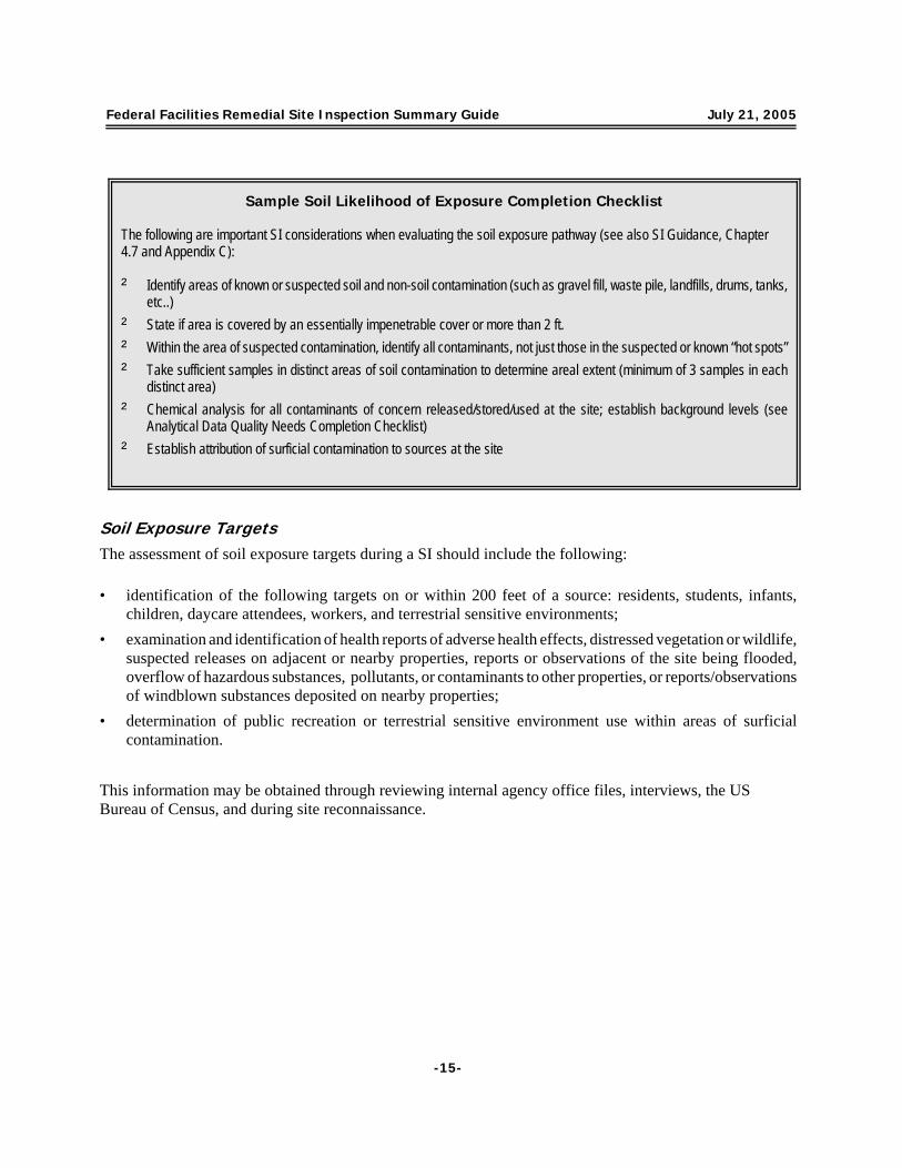
Soil Exposure TargetsThe assessment of soil exposure targets during a SI should include the following:
• identification of the following targets on or within 200 feet of a source: residents, students, infants,children, daycare attendees, workers, and terrestrial sensitive environments;
• examination and identification of health reports of adverse health effects, distressed vegetation or wildlife,suspected releases on adjacent or nearby properties, reports or observations of the site being flooded,overflow of hazardous substances, pollutants, or contaminants to other properties, or reports/observationsof windblown substances deposited on nearby properties;
• determination of public recreation or terrestrial sensitive environment use within areas of surficialcontamination.
This information may be obtained through reviewing internal agency office files, interviews, the USBureau of Census, and during site reconnaissance.
Sample Soil Likelihood of Exposure Completion Checklist
The following are important SI considerations when evaluating the soil exposure pathway (see also SI Guidance, Chapter4.7 and Appendix C):
‘ Identify areas of known or suspected soil and non-soil contamination (such as gravel fill, waste pile, landfills, drums, tanks,etc..)
‘ State if area is covered by an essentially impenetrable cover or more than 2 ft.‘ Within the area of suspected contamination, identify all contaminants, not just those in the suspected or known “hot spots”‘ Take sufficient samples in distinct areas of soil contamination to determine areal extent (minimum of 3 samples in each
distinct area) ‘ Chemical analysis for all contaminants of concern released/stored/used at the site; establish background levels (see
Analytical Data Quality Needs Completion Checklist)‘ Establish attribution of surficial contamination to sources at the site

Federal Facilities Remedial Site Inspection Summary Guide July 21, 2005
4 The air pathway should be evaluated only if a release is suspected or identified.-16-
Air Migration Pathway
This section of the SI Summary Guide provides information for documented releases or suspected releases ofhazardous substances, pollutants, or contaminants to the air migration pathway and associated targets ofconcern.4
Release to AirThe assessment of a release to air during a SI should include the following:
• description of air releases, including rapid dispersion of released substances in the atmosphere which canusually be detected only while the release is occurring;
• evaluation of the likelihood of release to air based on site and pathway conditions as to whether ahazardous substance release could be detected in air;
• visual examination and consideration of the site and its environs;• identification of reports of adverse health effects potentially resulting from migration of hazardous
substances, pollutants, or contaminants through the air, and evidence of distressed or dead vegetation;• visual documentation of any historical release to the air (for e.g., particulate matter observed entering
atmosphere and information that it contains hazardous substances, pollutants, or contaminants);
Sample Soil Exposure Targets Completion Checklist
The following are important SI considerations when evaluating the soil exposure pathway targets of concern (see also SIGuidance, Chapter 4.7 and Appendix C):
‘ For each area of suspected contamination, identify on or within 200 feet the:G Number of workers and residentsG Schools and day care facilities and number of attendeesG Any terrestrial sensitive environments (describe where sensitive environments/species are located)G Use of the resource (land) for commercial agriculture, commercial silviculture, or commercial livestock production or
grazing‘ Identify any residence, school, or daycare facility located on adjacent land previously owned or leased by the site
owner/operator‘ Identify any migration route to groundwater, surface water, or air‘ Identify any reports on adverse health effects‘ If subject property warrants sampling in the SI phase, determine if any neighboring property warrants sampling‘ Establish actual contamination by the collection and analysis of soil samples in residential areas and school yard; establish
background levels (see Analytical Data Quality Needs Completion Checklist)

Federal Facilities Remedial Site Inspection Summary Guide July 21, 2005
-17-
• identification of any evidence of bio-gas (e.g., methane) releases from below-ground containers or tanks,landfills, or buried surface impoundments.
This information may be obtained through reviewing internal agency office files, interviews, local airportweather stations, and during site reconnaissance.
Air TargetsThe assessment of air targets during a SI should include the following:
• description of wind currents which may cause air releases to disperse in any direction;• identification of human populations and sensitive environments within a 4 mile radius of the site;• identification of land uses within ½ mile only (commercial agriculture, silviculture, major or designated
recreation area).
Sample Release to Air Completion Checklist
The following are important SI considerations when evaluating the release of hazardous substances, pollutants, orcontaminants to the air pathway (see also SI Guidance, Chapter 4.8 and Appendix C):
‘ Has any release to air been suspected or identified?‘ Describe any direct observation of a release, analysis of air samples, or any potential release(s) to air‘ Identify and describe any reports (local Health Department, facility employees, or neighbors who may have reported health
effects such as headaches, nausea, or dizziness) of adverse health effects potentially from hazardous substances,pollutants or contaminants in air
‘ Identify and describe any reports or presence of odor from the site‘ Use any available analytical or circumstantial evidence (distressed or dead vegetation ) suggesting release of hazardous
substances, pollutants, or contaminants into the air‘ Collect and analyze air samples if:
G Air pathway contamination hypothesized during PA is solely responsible for further investigationG Public health concerns have been identified within the vicinity of the site
‘ Background samples (upwind or crosswind) and release samples (downwind of sources at the site) must be collected atthe same time and same heights above the ground
‘ While sampling, monitor wind speed, direction, and other atmospheric conditions

Federal Facilities Remedial Site Inspection Summary Guide July 21, 2005
-18-
Radionuclides
Investigation of radiation sites should be coordinated with EPA’s Office of Radiation Programs (ORP). Theassessment of radionuclides (or radioactive substances) during a SI should include the following:
• identification of specific radionuclides likely to be present, as releases are evaluated differently dependingon whether radionuclides are man-made or naturally occurring;
• identification of a background or reference concentration for the site vicinity for ubiquitous or naturally-occurring radionuclides;
• review of site history and past records to identify radionuclides and radioactive sources and waste streams;• determination of capabilities and limitations of various types of radiation field survey instruments in field
planning; the selected radiation field survey instrument should be appropriately calibrated;• selection of the appropriate field radiation survey technique (walkover or grid survey, downhole gamma
logging, special purpose surveys);• site map marking all areas with elevated exposure or count rates with survey stakes and record
measurements on a site map (in the field).
Sample Air Targets Completion Checklist
The following are important considerations when evaluating the air pathway targets of concern (see also SI Guidance,Chapter 4.8 and Appendix C):
‘ Within each of the 1/4, ½, 1, 2, 3, and 4-mile target distance rings from the site:G Determine distance to the nearest regularly occupied onsite or offsite buildingG Identify populations (residents, students, workers, subsistence gatherers)G Identify sensitive environments/species (terrestrial and aquatic within ½ mile only)
G Identify wetlands
‘ Establish actual contamination based upon observed a release of hazardous substance, pollutant, or contaminant into theair

Federal Facilities Remedial Site Inspection Summary Guide July 21, 2005
-19-
Sample Radionuclides Completion Checklist The following are important SI considerations when assessing radiation sites (see also SI Guidance, Chapter 3.8):
‘ Characterize sources using radioanalytical data:G Identify all radioactive substances and decay products presentG Determine the concentration of each radionuclideG Determine natural background concentration of each radionuclideG Delineate source dimensionsG Investigate source containment
‘ Use radio-analytical data to establish observed release differently depending upon whether radionuclides are man-madeor naturally occurring:G Identify all man-made and/ or naturally occurring radionuclies and decay products present in each migration pathwayG Determine the concentration of each radionuclide in these mediaG For each naturally occurring radionuclide detected, determine the mean site-specific natural background
concentrations and the minimum detectable activity (MDA) concentration in each mediumG For each man-made radionuclide detected, determine the lower limit of detection (LLD) in each mediumG For areas of observed soil contamination, determine gamma radiation exposure rates at one meter above the
surface of contaminated surficial materials; also establish natural radiation exposure rates at uncontaminatedbackground soil locations
‘ Identify background or reference concentration in site vicinity for ubiquitous or naturally-occurring radionuclides
Note: The Multi-Agency Radiological Laboratory Analytical Protocols (MARLAP) Manual is a good resource for identifyingappropriate analytical methods for radionuclides and can be found at http://www.epa.gov/radiation/marlap/links.htm

Federal Facilities Remedial Site Inspection Summary Guide July 21, 2005
-20-
SI NARRATIVE REPORT REQUIREMENTS
A SI at a Federal facility should include a SI Narrative Report. This Report should summarize what is knownabout the site, what is assumed or inferred, the activities conducted during the SI, all researched information,findings of the field investigation, and particularly the contamination associated with the site and migrationpathways. The SI Narrative Report should be accompanied by a photo documentation log, other attachmentsthat could include a sampling log, and reference materials, including any new analytical data, as described inthe Guidance for Performing Site Inspections Under CERCLA, 1992. A sample outline for such a report ispresented below.
Sample Outline for a SI Narrative Report
1.0 INTRODUCTION1.1 Project Objectives1.2 Project Scope
2.0 SITE BACKGROUND2.1 Site Location and Setting2.2 Site Description2.3 Site Ownership and History2.4 Site Operations and Waste Characteristics
2.4.1 Historical Waste Management Practices2.4.3 Regulatory Compliance
2.5 Previous Investigations2.6 Summary of Source Locations
3.0 FIELD ACTIVITIES AND ANALYTICAL PROTOCOL3.1 Sample Locations and Methodologies
3.1.1 Ground Water Samples3.1.2 Surface Water Samples3.1.3 Surface and Subsurface Soil Samples
3.2 Analytical Methods used3.3 Analytical results, with any review recommendations about data use3.4 Conclusions
4.0 QUALITY ASSURANCE/QUALITY CONTROL4.1 An EPA-approved QAPP that is project-specific Table 2, QAPP Requirement Summary, from the
IDQTF UFP-QAPP Manual (http://epa.gov/fedfac/documents/intergov_qual_task_force.htm)

Federal Facilities Remedial Site Inspection Summary Guide July 21, 2005
-21-
summarizes the elements to be included in a QAPP and Chapter 5 of that document clarifies thedata review process that is appropriate. These requirements are compatible with EPArequirements and too detailed to include here.
4.2 Documentation that QAPP specifications have been met, any deviations noted, and a statementabout the adequacy of the data for the intended use if all specifications are not met.4.2.1 A data review and usability report should be included.
5.0 MIGRATION/EXPOSURE PATHWAYS AND TARGETS5.1 Ground Water Migration Pathway
5.1.1 Local Geology and Hydrologic Setting5.1.2 Releases and Potential Releases to Ground Water5.1.3 Ground Water Migration Pathway Targets5.1.4 Sample Locations5.1.5 Ground Water Migration Pathway Analytical Results5.1.6 Ground Water Migration Pathway Conclusions
5.2 Surface Water Migration Pathway5.2.1 Hydrologic Setting5.2.2 Releases and Potential Releases to Surface Water5.2.3 Surface Water Migration Pathway Targets5.2.4 Sample Locations5.2.5 Surface Water Migration Pathway Analytical Results5.2.6 Surface Water Migration Pathway Conclusions
5.3 Soil Exposure Pathway5.3.1 Physical Source Access Conditions5.3.2 Actual or Potential Contamination Areas5.3.3 Soil Exposure Targets5.3.4 Sample Locations5.3.5 Soil Exposure Analytical Results5.3.6 Soil Exposure Conclusions
5.4 Air Migration Pathway5.4.1 Climate5.4.2 Releases and Potential Releases to Air5.4.3 Air Migration Pathway Targets5.4.4 Sample/Monitoring Locations5.4.5 Air Migration Pathway Analytical Results5.4.6 Air Migration Pathway Conclusions

Federal Facilities Remedial Site Inspection Summary Guide July 21, 2005
-22-
6.0 SUMMARY AND CONCLUSIONS
7.0 REFERENCES
8.0 PHOTO LOG
LIST OF FIGURES
LIST OF TABLES
LIST OF APPENDICESAnalytical results reportsQA Reports Other attachments

APPENDIX A
FEDERAL FACILITIES REMEDIAL PRELIMINARYASSESSMENT AND REMEDIAL SITE INSPECTIONSUMMARY GUIDE (INFORMATION SUPPLEMENT)

TABLE OF CONTENTS
Introduction . . . . . . . . . . . . . . . . . . . . . . . . . . . . . . . . . . . . . . . . . . . . . . . . . . . . . . . . . . . . . . . . . . . . . A-1Law/Regulations: Summary of Appropriate Legislation/Regulation . . . . . . . . . . . . . . . . . . . . . . . A-1Discussion of Definition of a Site. . . . . . . . . . . . . . . . . . . . . . . . . . . . . . . . . . . . . . . . . . . . . . . . . . . .A-3Site Assessment Process for Federal Facilities . . . . . . . . . . . . . . . . . . . . . . . . . . . . . . . . . . . . . . . . A-5
Diagram of overall FF Site Assessment Process . . . . . . . . . . . . . . . . . . . . . . . . . . . . . . . . . . . A-5Outline of Steps in Site Assessment . . . . . . . . . . . . . . . . . . . . . . . . . . . . . . . . . . . . . . . . . . . . . . A-5

Appendix A July 21, 2005Federal Facilities Remedial Preliminary Assessment and Remedial Site Inspection Summary Guide (Information Supplement)
A-1
INTRODUCTION
This section summarizes pertinent statutory and regulatory requirements that govern the Federal facilitiessite assessment process - specifically for conducting a Remedial Preliminary Assessment ( PA) or a RemedialSite Inspection (SI).
Law/Regulations: Summary of Appropriate Legislation/Regulation
Section 120(c) of the Comprehensive Environmental Response, Compensation, and Liability Act (CERCLA)requires EPA to establish a Federal Agency Hazardous Waste Compliance Docket (Docket) which containsinformation reported to EPA by Federal facilities that manage hazardous waste or from which hazardoussubstances, pollutants, or contaminants have been or may be released. The Docket is used to identify Federalfacilities that should be evaluated to determine if they pose a threat to public health and the environment andto provide a mechanism to make this information available to the public. The Docket is developed frominformation submitted by the Federal facility under the following authorities:
T Section 103 of CERCLA requires owners or operators of vessels or facilities to notify the NationalResponse Center of a release of a reportable quantity of a hazardous substance (notification of a releaseor potential release);
T Section 3005 of the Resource Conservation and Recovery Act (RCRA) provides EPA authority toestablish a permitting system for hazardous waste treatment, storage, and disposal (TSD) facilities, whichin turn requires the submission of certain information as part of the permit application (interimstatus/permitting authority). The hazardous waste permitting program is generally implemented byauthorized states;
T Section 3010 of RCRA requires hazardous waste generators, transporters, and TSD facilityowners/operators to notify EPA of their hazardous waste activities (notification of hazardous wasteactivity);
T Section 3016 of RCRA requires Federal facilities to submit an inventory of hazardous waste sites theyown or operate, or have owned and operated in the past (biennial inventory of hazardous waste activities).
Other relevant legislative/statutory citations include:
T Section 120(a)(2) of CERCLA provides that all guidelines, rules, regulations, and criteria for PreliminaryAssessments, Site Inspections, National Priorities List (NPL) listing and remedial actions are applicableto Federal facilities.
T Section 120(d)(1) of CERCLA requires that EPA take steps to assure that a PA be conducted for eachFederal facility included on the published list of Federal facilities reported pursuant to Section 120(c) ofCERCLA (the “Federal facilities docket”).
Appendix A July 21, 2005Federal Facilities Remedial Preliminary Assessment and Remedial Site Inspection Summary Guide (Information Supplement)
1 There may be instances when a facility included in the docket may not be listed in the CERCLIS database.
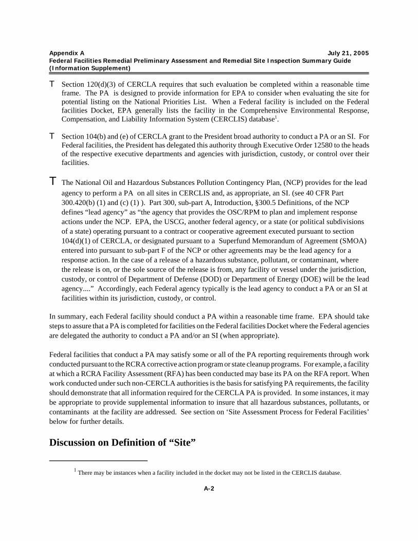
A-2
T Section 120(d)(3) of CERCLA requires that such evaluation be completed within a reasonable timeframe. The PA is designed to provide information for EPA to consider when evaluating the site forpotential listing on the National Priorities List. When a Federal facility is included on the Federalfacilities Docket, EPA generally lists the facility in the Comprehensive Environmental Response,Compensation, and Liability Information System (CERCLIS) database1.
T Section 104(b) and (e) of CERCLA grant to the President broad authority to conduct a PA or an SI. ForFederal facilities, the President has delegated this authority through Executive Order 12580 to the headsof the respective executive departments and agencies with jurisdiction, custody, or control over theirfacilities.
T The National Oil and Hazardous Substances Pollution Contingency Plan, (NCP) provides for the leadagency to perform a PA on all sites in CERCLIS and, as appropriate, an SI. (see 40 CFR Part300.420(b) (1) and (c) (1) ). Part 300, sub-part A, Introduction, §300.5 Definitions, of the NCPdefines “lead agency” as “the agency that provides the OSC/RPM to plan and implement responseactions under the NCP. EPA, the USCG, another federal agency, or a state (or political subdivisionsof a state) operating pursuant to a contract or cooperative agreement executed pursuant to section104(d)(1) of CERCLA, or designated pursuant to a Superfund Memorandum of Agreement (SMOA)entered into pursuant to sub-part F of the NCP or other agreements may be the lead agency for aresponse action. In the case of a release of a hazardous substance, pollutant, or contaminant, where the release is on, or the sole source of the release is from, any facility or vessel under the jurisdiction,custody, or control of Department of Defense (DOD) or Department of Energy (DOE) will be the leadagency....” Accordingly, each Federal agency typically is the lead agency to conduct a PA or an SI atfacilities within its jurisdiction, custody, or control.
In summary, each Federal facility should conduct a PA within a reasonable time frame. EPA should takesteps to assure that a PA is completed for facilities on the Federal facilities Docket where the Federal agenciesare delegated the authority to conduct a PA and/or an SI (when appropriate).
Federal facilities that conduct a PA may satisfy some or all of the PA reporting requirements through workconducted pursuant to the RCRA corrective action program or state cleanup programs. For example, a facilityat which a RCRA Facility Assessment (RFA) has been conducted may base its PA on the RFA report. Whenwork conducted under such non-CERCLA authorities is the basis for satisfying PA requirements, the facilityshould demonstrate that all information required for the CERCLA PA is provided. In some instances, it maybe appropriate to provide supplemental information to insure that all hazardous substances, pollutants, orcontaminants at the facility are addressed. See section on ‘Site Assessment Process for Federal Facilities’below for further details.
Discussion on Definition of “Site”

Appendix A July 21, 2005Federal Facilities Remedial Preliminary Assessment and Remedial Site Inspection Summary Guide (Information Supplement)
A-3
As stated in the section of the PA guide titled “Definition of Site: Clarification of Definition of ‘Site’ inCERCLA/SARA,” there has been confusion in the Federal facility context between the definition of “facility”and “site.” There are citations of two memos issued by EPA that address this issue. One is from GeorgeWyeth, entitled “Federal Facility Site Definition,” dated August 13, 1991, that focuses on how Federalfacilities should be defined for NPL listing purposes. The other is from Stephen Luftig entitled “Clarificationof NPL Listing Policy” dated August 3, 1995, that describes what is included in an NPL site, and specificallyaddresses Federal facilities.
Sometimes the two terms are used interchangeably while in other contexts they are used to refer to differentareas. The NCP does not define “site.” It does define “facility” as “any building, structure, installation,equipment, pipe or pipeline (including any pipe into a sewer or publically owned treatment works), well, pit,pond, lagoon, impoundment, ditch, landfill, storage container, motor vehicle, rolling stock, or aircraft, or anysite or area where a hazardous substance has been deposited, stored, disposed of, or placed, or otherwise cometo be located, but does not include any consumer product in consumer use or any vessel.” A Federal facilitymay include lands on a military installation, a DOE nuclear production facility, a National Air and SpaceAdministration (NASA) space center, a national forest, a national park or lands managed by the Bureau ofLand Management (BLM) or some other Federal agency. The DOD often refers to “sites” on theirinstallations. In this context, “site” refers to areas where a release has occurred and where contamination hasmigrated. The National Priorities List (NPL) is “the list of priority releases for long-term remedy evaluationand response.” Generally, releases on the NPL are referred to as “sites” although they may be identified bythe facility’s name.
This guide will use the term “site(s)’ to be consistent with common usage and to be consistent with theattachment to the “Clarification of NPL Listing Policy” memorandum of August 3, 1995, from StephenLuftig, which was written to address the perception that Federal facilities are listed on a fenceline-to-fencelinebasis. The attachment contained new wording for preambles to NPL rulemaking documents. Relevantlanguage states that “While geographic terms are often used to designate the site in terms of the propertyowned by the particular party, the site properly understood is not limited to that property (e.g.,, it may extendbeyond the property due to contaminant migration), and conversely may not occupy the full extent of theproperty (e.g., where there are uncontaminated parts of the identified property, they may not be, strictlyspeaking, part of the “site.”) The “site” is thus neither equal to nor confined by the boundaries of any specificproperty that may give the site its name, and the name itself should not be read to imply that this site iscoextensive with the entire area within the property boundary of the facility or plant. The precise nature andextent of the site are typically not known at the time of listing on the NPL.”
Defining the extent of a “site” for Federal facilities can be even more complex than for private sites. Federalfacilities may consist of large areas (e.g., Federal lands or installations), much of which is not likely to beaffected by releases of hazardous substances, pollutants, or contaminants. As a legal matter, the “site” israrely coextensive with the boundaries of the installation, plant, or Federal lands. Rather, per EPA’s Office

Appendix A July 21, 2005Federal Facilities Remedial Preliminary Assessment and Remedial Site Inspection Summary Guide (Information Supplement)
2See the August 13, 1992, Memorandum “Federal Facility Site Definition,” from GeorgeB. Wyeth, Attorney.
A-4
of General Counsel2, the site consists of all contaminated areas (hazardous substance, pollutant, orcontaminant releases) within the area used to identify the site, as well as any other location to which thatcontamination has come to be located, or from which that contamination came.

Appendix A July 21, 2005Federal Facilities Remedial Preliminary Assessment and Remedial Site Inspection Summary Guide (Information Supplement)
3Hazard Ranking System; Final Rule, 40 CFR Part 300, Appendix A, Federal Register, Vol. 55, No. 241, December14, 1990.
A-5
Purpose of a Preliminary Assessment(PA)**
The main purpose of a PA is to distinguish between sitesthat pose little or no threat to human health and theenvironment and sites that require further investigation. The PA generally is a compilation of existing informationabout the site and its surrounding area. This generallyincludes:
• a reconnaissance of the site and its environs• documenting current site conditions to include
hazardous waste on-site• populations and other targets, and resources that
might be threatened/affected by the site • photo documentation• migration pathways (ground water, surface water, soil,
air)**Refer to Guidance for Performing PreliminaryAssessments Under CERCLA, 1991
Site Assessment Process for Federal Facilities
Diagram of overall Federal Facilities Site Assessment Process
Outline of Steps in Site AssessmentThe Superfund site assessment process typicallybegins with site discovery or notification of arelease or potential of a release into theenvironment and/or notification to EPA of apotential hazardous waste site. However, withFederal facilities, the process starts when thefacility has been listed on the Federal AgencyHazardous Waste Compliance Docket. EPA willtypically then request the Federal facility to submita PA report within a reasonable time frame(determined upon consultation with EPA).
When a Federal facility provides a PA report for asite to EPA, EPA evaluates the site in accordancewith the Hazard Ranking System (HRS) final ruleto determine whether the site poses a threat tohuman health and/or the environment3.
If EPA determines that the facility or site does notpose a threat to human health and the environment sufficient to warrant Superfund action, EPA typically willdesignate a decision of “No Further Remedial Action Planned” (NFRAP) under Superfund. A decision notto take further response/remedial action under the Superfund program usually is based on a finding that thereis no significant threat to human health or the environment and the site would not be proposed to the National

Appendix A July 21, 2005Federal Facilities Remedial Preliminary Assessment and Remedial Site Inspection Summary Guide (Information Supplement)
4In certain cases, a combined Preliminary Assessment/Site Inspection (PA/SI) may be warranted. A PA/SIincorporates the Preliminary Assessment and the Site Inspection into one effort allowing for potential cost savings and expeditedassessment schedules. The PA/SI is particularly useful at remote sites where travel and mobilization costs are high or at siteswhere the necessity for conducting an SI is fairly certain based upon a review of the available information.
A-6
Purpose of a Site Inspection (SI)**
The main purpose of site inspection (SI) is to collectand analyze waste and environmental samples toidentify the substances present, determine whetherhazardous substances are being released to theenvironment, and determine whether hazardoussubstances have impacted specific targets. Thisusually involves:
• site reconnaissance, field observations andmeasurements
• the review of available information, includinganalytical data
• development of work and sampling (and other)plans
• sample collection and evaluation of all data• photo documentation• preparation of SI report
**Refer to Guidance for Performing Site Inspections
Priorities List (NPL) at that time by the EPA. (If new or additional information becomes available suggestingthat the site may warrant further evaluation, EPA will re-evaluate the site accordingly). This decision doesnot preclude any further action at the facility by the State or other Federal agency.
If the PA concludes that further investigation is warranted, then a Site Inspection (SI) will be performed.When the Federal facility provides the SI report or the combined PA/SI4 report for a site to EPA, EPAevaluates the site in accordance with the HRS todetermine if the site poses a threat to human health orthe environment. If the site is found to present nosignificant threats to human health or the environment,the SI serves as a second screening investigation andthe site is designated a decision of “No FurtherRemedial Action Planned” under Superfund.
When initial site sampling verifies some or allhypotheses, or other data indicate the site may pose asufficient threat to warrant NPL consideration, all datanecessary to prepare an HRS scoring package topropose the site to the NPL should be collected. Tomake a site disposition decision, EPA considers all datain the light of the SI results to evaluate whether the sitescore will be high enough to warrant preparation of theHRS package.
Federal facilities are encouraged to contact theappropriate EPA regional office prior to submission oftheir PA (and SI if performed) to discuss the siteassessment process, site specific issues, problems, tribaland state involvement, etc. Such discussions with the regional office should further help the Federal facilityin adequately completing the PA (and SI) so that EPA can evaluate the site in accordance with the HRS, ifwarranted, within a reasonable time frame.
APPENDIX B

Appendix B July 21, 2005Federal Facilities Remedial Site Inspection Summary Guide (Example Completion Checklists)
B-1
Sample Field and Analytical Data Quality Needs Completion ChecklistA comprehensive and well-documented quality assurance/quality control (QA/QC) program is essential for obtaining preciseand accurate analytical data that represents the site. The following are important SI QA/QC considerations:
‘ Develop a Quality Assurance Project Plan (QAPP) using the Uniform Federal Policy for Quality Assurance ProjectPlans.
‘ For Federal facilities, the responsible organization should prepare the QAPP for review and approval by the appropriateregulatory authority.
‘ Include a table or matrix that correlates field sample numbers with laboratory sample numbers and related sampleresults
‘ Include a map of sample locations, contaminated areas, and any other features pertinent to data evaluation‘ Make notations on nature of sample (e.g., whether aqueous sample is muddy or clear, filtered or unfiltered)‘ Establish background levels based on sampling results or published data‘ Determine background levels of hazardous substance(s) in order to:
G establish which ground water, surface water, sediment, or air samples are significantly higher than the backgroundlevel for the same media.
G define observed surficial soil or waste contaminationG establish actual contamination of ground waterG attribute hazardous substance(s) to sources at the siteG establish natural or ubiquitous radiation exposure rates
‘ Background samples should be collected in the media of concern and where the hazardous substance, pollutant, orcontaminant is not likely to be present
‘ Background and release samples should be comparable (i.e., similar location within media, time of sampling, nature ofsamples)
‘ All samples should be analyzed according to the QAPP, using appropriate analytical methods selected to achieveproject quality objectives as well as adequate QA/QC data. Consider both fixed laboratory and/or field analyticalmethods appropriate for the Contaminants of Concern and that have adequate QA and QC specifications to ensure thatdata can be effectively reviewed.
‘ Adequate documentation of analytical data QA/QC to determine if QAPP Data Quality Objectives ( DQOs) were metand data are suitable for intended use, following data review requirements as established in the QAPP.

Appendix B July 21, 2005Federal Facilities Remedial Site Inspection Summary Guide (Example Completion Checklists)
B-2
Sample Site and Source Characterization Completion Checklist
The following are important SI considerations when characterizing the site and sources, including hazardous waste quantity(see also SI Guidance, Chapter 4.2 and Appendix C):
‘ Define and describe the site‘ Describe past and current operations and site conditions‘ Summarize (past and current):
G Waste treatment, storage, and disposal activities (documented or alleged) including all spills and response(removal or remedial) actions
G Any previous sampling data identifying hazardous substances, pollutants, or contaminants at each source and howthey relate to hazardous substances, pollutants, or contaminants suspected to be present at the site
‘ Describe adjacent or nearby property, land uses, and tribe/native entities (including any areas for their reservedhunting, fishing, and gathering rights)
‘ Identify, describe & characterize sources:G Waste streams (past and current)G All hazardous substances, pollutants, or contaminants and wastesG Source typeG Quantity of wasteG Measurement of each source (area/volume, etc.)G Physical state of wasteG Source area accessibility G Containment features, if any, and their effect on migration of hazardous substances, pollutants, or contaminants G Specific areas on the site where wastes may have been disposed, deposited, stored, or handled (based on past
and current activities)G Any other potential source areasG Indicate source areas (including potential source areas) on a Site Sketch to be included in the SI Narrative ReportG Identify and describe major pathways of migration (ground water, surface water, soil, air) and the routes that
hazardous substances, pollutants, or contaminants may take to reach these pathways (e.g., flooding, overlandflow, vapor migration)
‘ Sample the sources to determine one or more of the following:G Identify types of wastes and hazardous substances, pollutants, or contaminantsG Attribute hazardous substances, pollutants, or contaminants to the siteG More fully describe any observed surficial contaminationG Delineate source boundaries and containment

Appendix B July 21, 2005Federal Facilities Remedial Site Inspection Summary Guide (Example Completion Checklists)
B-3
Sample Release to Ground Water Completion Checklist
The following are important considerations when evaluating releases or suspected releases of hazardous substances,pollutants, or contaminants to the ground water pathway (see also SI Guidance, Chapter 4.5 and Appendix C):
‘ Describe local geology and hydrogeology, including:G Soil types and permeabilityG Aquifers and ground water useG Low-permeability or confining layers, impeding ground water movement into or between aquifersG Aquifer discontinuitiesG Hydrologic interconnections between multiple aquifersG Karst terrain and featuresG Infiltration ratesG Precipitation levels and occurrence of extreme rain eventsG Depth to aquifer
‘ Describe containment features (engineered structures such as liners or a leachate collection system)‘ Describe the mobility of the hazardous substances, pollutants, or contaminants in ground water‘ Provide maps of ground water wells used for monitoring, drinking, or other purposes‘ Document any release to ground water by direct observation (for e.g., material containing hazardous substances,
pollutants, or contaminants is known to have entered ground water through direct deposition or seen entering groundwater)
‘ Document release to ground water by chemical analysis: G Identify release well type (municipal or private drinking water well, monitoring well)G Samples must be collected from representative release and background wells finished in the same aquifer and
screened in a comparable zoneG Determine depth to aquifer in mean sea level (rather than below the ground surface)G Designate if ground water samples are filtered or unfilteredG Analyze all contaminants of concern released/stored/used at the site
‘ When necessary, monitoring wells may need to be installed to:G Establish an observed release to ground waterG Establish background levelsG Establish attribution of groundwater contamination to sources at the siteG Determine direction of groundwater flow

Appendix B July 21, 2005Federal Facilities Remedial Site Inspection Summary Guide (Example Completion Checklists)
B-4
Sample Ground Water Targets Completion Checklist
The following are important SI considerations when evaluating the ground water pathway targets of concern (see also SIGuidance, Chapter 4.5 and Appendix C):
‘ Within a 4 mile radius of each potential or actual source, identify:G Drinking water systems at the Federal facility site and nearby areas and residences (private/municipal wells,
blended water distribution system, surface water usage, population served or number of service connections andcounty multiplier, annual average well production, backup or standby wells)
G Nearest drinking water well, the distance from the source, and the population served by the wellG All existing wells (private and/or public drinking water wells, irrigation wells, livestock watering, etc..)G Any multiple aquifer systems
‘ Identify drinking water wells within 1/4, ½, 1, 2, 3, and 4 miles of the sources, and quantify, and as necessary,apportion populations associated with each (among aquifers and distance rings and between surface water intakes andground water wells)
‘ Establish actual contamination to ground water by sampling target drinking water (municipal or private) wells within the4 mile radius, up-and down-gradientb; also establish background levels (see Analytical Data Quality Needs CompletionChecklist)
‘ Obtain well construction information for all target drinking water wells and identify the screening intervals as well as theaquifer, or aquifers, the wells draw from
‘ Identify any nearby drinking water wells that have been closed (past and current)‘ Identify any reports of foul tasting or smelling water from nearby wells‘ Identify any drinking water wells located between the site and other wells suspected of contamination‘ Determine if any nearby wells have a large drawdown or high production rate (cone of depression, change in flow
gradients) bIf sampling within the 4 mile radius of every potential or actual source cannot be conducted off the Federal facility property,the Federal facility should obtain documentation of existing analytical results from private/municipal drinking water wells fromthe local health department, or other local/state officials.

Appendix B July 21, 2005Federal Facilities Remedial Site Inspection Summary Guide (Example Completion Checklists)
B-5
Sample Release to Surface Water Completion Checklist
The following are important considerations when evaluating the release of hazardous substances, pollutants, orcontaminants to the surface water pathway (see also SI Guidance, Chapter 4.6 and a C):
‘ Describe each watershed’s hydrology and topography for a 15- mile TDL, including:G Surface water bodies, including wetlands, and their proximity to a sourceG Surface water body flow ratesG Precipitation levels, occurrence of extreme rain events, and potential for floodingG Soil types and infiltration ratesG Size of drainage area
‘ Identify and map:G Overland runoff routes, and shortest overland distance to surface water from a sourceG Probable points of entry (PPEs) where hazardous substances, pollutants, or contaminants are likely to have
migrated from each source or identify and document the nearest surface water body and its distance from the siteG Probability and location of ground water discharge to surface waterG Predominant type of water body between PPE to surface water and nearest drinking water intake (i.e., river, lake,
both)G Fisheries or sensitive environments
‘ Identify visual or alleged evidence of direct deposition of hazardous waste to sediments and surface water:G Vegetation conditionG Historical flooding of source areasG Absence or presence of terrestrial and/or aquatic wildlifeG Any unnatural discoloration
‘ Document any release to surface water by direct observation (for e.g., material containing hazardous substances,pollutants, or contaminants is known to have entered surface water through direct deposition, is seen entering surfacewater, or is present in a source area in contact with surface water through flooding)
‘ Document a release to the surface water migration pathway by chemical analysis:G Identify type of release samples (aqueous, sediment, effluent, sessile benthic organism)G The release and upstream background samples must be from similar setting, flow, and physical characteristics
(for e.g., sediment grain size)‘ Establish attribution of surface water contamination to sources at the site by collecting samples upstream of the PPE‘ Specifically, sample as appropriate, surface water, or sediment or both as determined by chemical characteristics,
time of release, surface water flow, etc., to establish where contamination has come to be located; analyze for allcontaminants of concern released /stored/used at the site

Appendix B July 21, 2005Federal Facilities Remedial Site Inspection Summary Guide (Example Completion Checklists)
B-6
Sample Surface Water Targets Completion Checklist
The following are important SI considerations when evaluating the surface water pathway targets of concern (see also SIGuidance, Chapter 4.6 and Appendix C):
‘ Identify all targets within the 15-mile Target Distance Limit (TDL) of each source at the site (in multiple surface watermigration routes where applicable):G Drinking/resource water intakes (including backup or standby intakes)G Fisheries (recreational, commercial, subsistence)G Sensitive environments (species, wetlands)
‘ For each intake,G State if intake is suspected to be contaminatedG State the distance from the PPE to that intakeG Quantify population served (including workers and students) G Determine the flow rateG Estimate annual human food chain productionG Measure the distance from the PPE to the nearest intakeG Establish actual contamination to surface water by sampling drinking water intake; also establish background
levels (see Analytical Data Quality Needs Completion Checklist)G Identify any other sample results (sediment, aqueous, effluent, sessile benthic organism)
‘ For each fishery,G State if fishery is suspected to be contaminatedG State the distance from the PPE to that fishery G Determine the flow rateG Identify fishery with the lowest flow characteristicG Establish actual contamination by taking edible tissue sample results from sessile benthic organisms, non-sessile
benthic organisms, or finfish, amphibians, and reptiles; also establish background levels (see Analytical DataQuality Needs Completion Checklist)
G Identify any other sample results (sediment, aqueous, effluent)‘ For each sensitive environment
G State if it is suspected to be contaminatedG State the distance from the PPE to the sensitive environmentG Indicate whether sensitive environments are present in or adjacent to the surface water migration pathway G Identify the sensitive environment with the lowest flow characteristicG If wetlands, provide wetland frontageG Establish actual contamination to wetland/sensitive environment using aqueous samples; also establish
background levels (see Analytical Data Quality Needs Completion Checklist)G Identify any other sample results (sediment, aqueous, effluent, edible sessile benthic organism)
‘ Identify if any intake, fishery, or recreational area has ever been closed

Appendix B July 21, 2005Federal Facilities Remedial Site Inspection Summary Guide (Example Completion Checklists)
B-7
Sample Soil Likelihood of Exposure Completion Checklist
The following are important SI considerations when evaluating the soil exposure pathway (see also SI Guidance, Chapter4.7 and Appendix C):
‘ Identify areas of known or suspected soil and non-soil contamination (such as gravel fill, waste pile, landfills, drums,tanks, etc..)
‘ State if area is covered by an essentially impenetrable cover or more than 2 ft. ‘ Within the area of suspected contamination, identify all contaminants, not just those in the suspected or known “hot
spots”‘ Take sufficient samples in distinct areas of soil contamination to determine areal extent (minimum of 3 samples in each
distinct area) ‘ Chemical analysis for all contaminants of concern released/stored/used at the site; establish background levels (see
Analytical Data Quality Needs Completion Checklist)‘ Establish attribution of surficial contamination to sources at the site
Sample Soil Exposure Targets Completion Checklist
The following are important SI considerations when evaluating the soil exposure pathway targets of concern (see also SIGuidance, Chapter 4.7 and Appendix C):
‘ For each area of suspected contamination, identify on or within 200 feet the:G Number of workers and residentsG Schools and day care facilities and number of attendeesG Any terrestrial sensitive environments (describe where sensitive environments/species are located)G Use of the resource (land) for commercial agriculture, commercial silviculture, or commercial livestock production
or grazing‘ Identify any residence, school, or daycare facility located on adjacent land previously owned or leased by the site
owner/operator‘ Identify any migration route to groundwater, surface water, or air‘ Identify any reports on adverse health effects‘ If subject property warrants sampling in the SI phase, determine if any neighboring property warrants sampling‘ Establish actual contamination by the collection and analysis of soil samples in residential areas and school yard;
establish background levels (see Analytical Data Quality Needs Completion Checklist)

Appendix B July 21, 2005Federal Facilities Remedial Site Inspection Summary Guide (Example Completion Checklists)
B-8
Sample Air Targets Completion Checklist
The following are important considerations when evaluating the air pathway targets of concern (see also SI Guidance,Chapter 4.8 and Appendix C):
‘ Within each of the 1/4, ½, 1, 2, 3, and 4-mile target distance rings from the site:G Determine distance to the nearest regularly occupied onsite or offsite buildingG Identify populations (residents, students, workers, subsistence gatherers)G Identify sensitive environments/species (terrestrial and aquatic within ½ mile only)G Identify wetlands
‘ Establish actual contamination based upon observed release of hazardous substance(s) into the air
Sample Release to Air Completion Checklist
The following are important SI considerations when evaluating the release of hazardous substances, pollutants, orcontaminants to the air pathway (see also SI Guidance, Chapter 4.8 and Appendix C):
‘ Has any release to air been suspected or identified?‘ Describe any direct observation of a release, analysis of air samples, or any potential release(s) to air‘ Identify and describe any reports (local Health Department, facility employees, or neighbors who may have reported
health effects such as headaches, nausea, or dizziness) of adverse health effects potentially from hazardoussubstances, pollutants or contaminants in air
‘ Identify and describe any reports or presence of odor from the site‘ Use any available analytical or circumstantial evidence (distressed or dead vegetation ) suggesting release of
hazardous substances, pollutants, or contaminants into the air‘ Collect and analyze air samples if:
G Air pathway contamination hypothesized during PA is solely responsible for further investigationG Public health concerns have been identified within the vicinity of the site
‘ Background samples (upwind or crosswind) and release samples (downwind of sources at the site) must be collectedat the same time and same heights above the ground
‘ While sampling, monitor wind speed, direction, and other atmospheric conditions

Appendix B July 21, 2005Federal Facilities Remedial Site Inspection Summary Guide (Example Completion Checklists)
B-9
Sample Radionuclides Completion Checklist The following are important SI considerations when assessing radiation sites (see also SI Guidance, Chapter 3.8):
‘ Characterize sources using radioanalytical data:G Identify all radioactive substances and decay products presentG Determine the concentration of each radionuclideG Determine natural background concentration of each radionuclideG Delineate source dimensionsG Investigate source containment
‘ Use radioanalytical data to establish observed release differently depending upon whether radionuclides are man-made or naturally occurring:G Identify all man-made and/ or naturally occurring radionuclies and decay products present in each migration
pathwayG Determine the concentration of each radionuclide in these mediaG For each naturally occurring radionuclide detected, determine the mean site-specific natural background
concentrations and the minimum detectable activity (MDA) concentration in each mediumG For each man-made radionuclide detected, determine the lower limit of detection (LLD) in each mediumG For areas of observed soil contamination, determine gamma radiation exposure rates at one meter above the
surface of contaminated surficial materials; also establish natural radiation exposure rates at uncontaminatedbackground soil locations
‘ Identify background or reference concentration in site vicinity for ubiquitous or naturally-occurring radionuclides
Note: The Multi-Agency Radiological Laboratory Analytical Protocols (MARLAP) Manual is a good resource for identifyingappropriate analytical methods for radionuclides and can be found at http://www.epa.gov/radiation/marlap/links.htm

1 Section 105(a)(8)(B) also refers to "facilities"' on theNPL. In general, EPA uses the term "facility" interchangeably withthe terms "release" and "site". The term "facility" as defined insection 101(9) of CERCLA includes any "area where a
UNITED STATES ENVIRONMENTAL PROTECTION AGENCY
WASHINGTON, D.C. 20460
TO: Suzanne WellsSite Assessment BranchOffice of Solid Waste and Emergency Response (OS-230)
A number of questions have arisen recently regarding the wayin which federal facilities are defined for purposes of NPLlisting. In particular, I have received a memorandum from RichardMcAllister, of the office of Regional Counsel in Region X, askingabout how federal facilities may be described in listing packagesto ensure that all the potential sources that EPA considersappropriate to include in the NPL site are in fact included. Thismemorandum responds to that from Region X, and somewhat moregenerally to other questions that have arisen about federalfacility site definition.
Federal facilities are often very large and encompass multiplepotential sources of contamination arising out of a variety ofdifferent activities. Because of their size, and the fact that siteinvestigations are not conducted under direct EPA supervision, itis not always possible to ensure that all areas of contaminationwithin the facility boundaries have been identified at the time thefacility is considered for NPL listing. While these features arenot unique to federal facilities, they tend to arise mostfrequently at such facilities. These features of federal facilitieshave given rise to a number of problems for the site listingprocess.
The NPL is, according to section 105 (a)(8)(B) of CERCLA, alist of the nation's highest priority "releases." An NPL sitetherefore consists of a release (or releases), not (as is sometimesbelieved) a geographic unit defined by property lines.1

2
hazardous substance has been deposited, stored, disposed of, orplaced", and that area could extend beyond the area that isactually contaminated. However, the term "facility" as used inCERCLA is not necessarily equivalent to what is commonly meant inreferring to a "federal facility" -- i.e. an entire military orother government installation.
2 See Washington State Department of Transportation v.EPA, 917 F. 2d 1309 (D.C. Cir. 1990) (source not mentioned in thelisting package could later be treated as part of the site when itwas found to be contributing to the listed contamination).
While geographic terms are often used to designate the site (e.g.,the "Jones Co. plant site"), and listing packages sometimesdescribe the site in terms of the property owned by a particularparty, the site properly understood is not limited to that property(e.g., it may extend beyond the property due to contaminantmigration), and conversely may not occupy the full extent of theproperty (e.g., where there are uncontaminated parts of theidentified property, they may not be, strictly speaking, part ofthe "site"). The precise nature and extent of the site aretypically not known at the time of listing. The full extent of thesite, including areas to which contamination has "come to belocated", and sources not identified at listing, will be furtherdelineated in the course of the RI/FS and the remedial actionalthough in many cases the precise extent of contamination is neverknown. See 55 Fed. Reg. 35504-05 (August30, 1990).
What the site consists of depends on how the listed release(or group of releases) is described in the listing package. In somecases this is straightforward, as where there is a known source anda groundwater plume. In other cases, the release may be defined interms of an ongoing activity, such as the disposal of wastesgenerated by a particular company. In other cases, the site mayconsist of an identified area of known contamination with thesources less than fully specified.2 Where a disposal unit such as alagoon or landfill is involved, the location of that unit will alsohelp to define the site. (For example, where a site is described asthe "X Landfill", the site would include (but not necessarily belimited to) the landfill and any migration or releases from it).Finally, the site may be defined by reference to geographicboundaries for listing purposes, within the "site" ultimatelyconsisting of any contamination within those boundaries (and anyother areas to which such contamination has come to be located).

3
3 Region X's memo correctly notes that for purposes oflisting federal "facilities" on the Federal Agency Hazardous WasteCompliance Docket under section 120(c) of CERCLA, EPA has said thatit uses the RCRA definition of "facility", which is based onproperty boundaries. Thus, on the docket, each facility is listedonly once, even if it contains multiple areas of contamination. ForNPL listing purposes, however, the CERCLA definition of "facility"applies
4 The converse is not true, however. It would not beappropriate to NFRAP a facility on the basis of data from only afew key sources. If the preliminary scoring of a few sourcesresults in a score below 28.5, but other sources are known thatcould raise the score above 28.5, those other sources should not beignored. (The region could use its discretion to conclude withoutdetailed site investigation that even if all sources were
These general rules apply to federal facilities as well asother NPL sites.3 When a site is listed as "Smith Air Force Base",the site is not necessarily coextensive with the boundaries of thebase. Rather, it is defined by the listing package. Where there aremultiple sources or areas of known contamination, all sources andcontaminated areas referred to in the package are included in thesite. In addition, the site may be defined in such a way as toinclude any contaminated areas within the facility boundaries butnot specifically identified as of the listing date. (If thisapproach is used, it is recommended that the method of defining thesite is made very clear in the listing package to avoidmisunderstandings later in the process.) Alternatively, EPA couldchoose to define the site to include only portions of a particularfacility, either if it concludes that other portions are clean orif it concludes that it does not make sense administratively toaddress all contamination within the facility boundaries as part ofone site.
The memo from Region X asked about the level of detail neededto describe sources at federal facilities in the listing package soas to make clear that they are part of the site. The Regionindicated that it plans to characterize fully only those sourcesthat drive the HRS score, and to describe other areas known orbelieved to be sources of contamination in a more general way. TheRegion asked if this would be sufficient, and if so, how todocument the latter sources.
In general, the approach described by Region X should besufficient to include all the sources within the site, includingthose that are not characterized in detail. If a few sources at afacility are sufficiently serious to generate an HRS score over28.5 by themselves, it is sufficient to use those sources inscoring the site and to describe other known sources only ingeneral terms.4 The latter would then be part of the NPL site.

4
The more general descriptions need not conform to any specific,uniform format; generally, the kinds of identifies that would beuseful would be references to the approximate location of thesource, and the kind of activity that caused the contamination (oris believed to have caused contamination). If specific contaminantscan be identified, either from actual sampling or from knowledge ofthe activity involved, this would be helpful but is not essential.Where sources are known because they have been identified instudies such as Installation Restoration Program reports, it may behelpful to include the portion of the study identifying the sourcein the listing package.
In such a case, the site as listed would include all thesources identified in the package, all areas to which contaminationfrom those sources has come to be located, and in addition (unlessEPA chooses otherwise) any sources not identified at the time oflisting that are later found to have contributed to contaminationthat was identified in the listing package. For example, if thelisting package identifies groundwater contamination at some pointon the facility, and one or more known sources of thatcontamination, and other sources are later found to havecontributed to that contamination, those later-identified sourceswould be considered part of the site. (To avoid disagreement later,it is probably advisable to make this clear in the listingpackage.)
Alternatively, it is possible to score the site based on asmall number of sources, and simply describe the site at listing asincluding those sources and all other contaminated areas within theboundaries of the facility. In that case the site would include anycontamination, either known at the time of listing or discoveredlater, that is within those boundaries. If this approach isfollowed, it is recommended that the description be made very clearso that all parties potentially affected may be made aware of thescope of the site. (For example, this approach could bring withinthe site contamination originating outside the facility from aprivate source, and unless the definition is clear outside privateparties might assume that the listing did not affect them.) Inaddition, to serve the NPL's public information function, it isgenerally advisable even under this approach to describe in generalterms those sources that are known at the time of listing.
The fact that sources at a federal facility are notcontiguous, and involve different contaminants from differentactivities, does not preclude grouping them together as a singlesite. It has been EPA's policy since the NPL was first establishedthat noncontiguous releases may be "aggregated" as a
scored the facility would be unlikely to qualify for the NPL, andNFRAP it on that basis.)

5
5 The question of site boundaries pending finalcharacterization has come up from time to time in connection withproposals to sell or lease portions of the facility. Absent someprovision in the IAG restricting the freedom of the agency totransfer a portion of the site, neither NPL listing nor sitedefinition in fact have any effect on the owner agency's ability tosell property: the ability to sell is governed primarily by section120(h)(3) of CERCLA which is independent of NPL listing.
single site in certain cases. (See 48 FR 40663 (Sept. 8, 1983)).When EPA lists a variety of unrelated sources at a federal facilityas one site, it is in effect utilizing the aggregation policy(although this is not always explicit in the listing packages). Thefactor that makes aggregation appropriate in such cases isgenerally the presence of a single responsible party which willserve as lead agency for any response and with whom EPA would haveto enter into an IAG. There are clear administrative advantages indealing with such sites collectively so as to simplify the responseprocess, typically in a single umbrella IAG. At some federalfacilities, however, administrative considerations may militate infavor of disaggregation; the DOE Hanford facility, for example,includes several distinct NPL sites.
It should be noted that, even if a site is identified forlisting purposes by reference to the area within the facilityboundaries, the NPL "site" includes only those areas that arecontaminated (including both sources and areas to whichcontamination has come to be located). Areas within the facilityboundaries that EPA ultimately concludes are clean would thus notbe considered part of the "site". Pending completion of the RI/FSand ROD, the extent of the site may be uncertain, and all portionsof the facility may be considered at least potentially part of thesite, except to the extent EPA is satisfied based on the availableevidence that certain portions are in fact uncontaminated.5

UNlfED STATES ENVIRONMENTAL PROlECilON AGENCY ,. WASHINQTON, O.C. 2 0 4 ~
, . -
SUBJECT: ~lmrification of NPL Listing Policy
TO: I'
Director, Waste Management Division Regions I, IV, V, VII
Director, Emergency and Remedial Response D i v i s i o n . Region I1 Director, Hazardous Waste Management Division Regions 111, VI, Vf 11, IX
Director, Hazardous Waste Division Region X
The purpose of this memo is to info& you of a recent restatement of our National Priorities L i s t (NPL). listing policy concerning what is included in the NPL site. This addresses the perception that Federal facilities (most particularly) are listed on a fenceline-to-Penceline basis. This percept.ion of fenceline- to-fenceline listing has created a negative impact on the Superfund program, which this restatement should ameliorate.
On mrch 31, 1995, Administrator Browner sent a letter to Governor Voinovich of Oh10.~ In that letter Ms. Browner pmmised that EPA w d clarify, "the Agency's NPL,[Wational Priorities ~ist] l i m Z n g policy... by the summer of I995."
As a remalt of the Adrinistratorf~ letter, the S i t e Mssesmnt Branch, within tlie Office of Emergency and Remedial Response, formad an interagency workgrou .to work w & h tha Department of mfonsr to clarify the pol P cy. Tiiio d l e i f i p a t i o n stat-t of the listing policy has been imp1eiented ky three distinct actions.

-.
. L .
developad new wording fos-' the preambles s.. The wording, approved by-the O f f i c e
ar in future. ~ederal Register es that NPL'sites include,only
wntaminated areas. Clean portions arb not included even-if the site name implies that the entire (fenceline-to-fenceline) f a c f i i t y i s l isted. This clarification is needed beca~se of the nisconception stakeholders have with what is included in the listing [a copy of the wording is attached]. i
Second, EPA has amended a l l currently proposed and final NPL docket listing packages to include a clear statement that the sites are not based upon the property boundaries, but rather the areas of contamination. A notice to that effect will be placed in the Federal ~?g i s t er at the next opportunity.
Third, the group has tasked t h e quality assurance reviewers of Hazard Ranking System packages to f l a g packages which are not consistent with this policy,
Further, the group intends to prepare a fact sheet to explain the .policy.
If you have any questions regarding this clarification please call Trish Gowland of my staef at ( 7 0 3 ) 603-8721.
Attachment
cc: Thomas W. L. Piccall, DOD. Tim Fields, OSWER. Steve Herman, OECA Jerry Clifford, Acting Director, OSRE Barry Breen, Director, FFEO Jim Woolford, Director, FFRRO mrry Reed, 6- Superfund Chiefs (Regions f - X) R e q i a m l Coun161 Branch Chiefs ( R V ~ O P S I - ' X) Alan Cnrgien, OGC . Seth Tharas fnw, FFRZO Patricia Gowland, OgRR

. -
. .
, - - . . . . . . . . . .
ties List -dms .not -d&cribe reIea4ss in ; it wnuld be neither feasfble.hor
purpose of the. NPL (as the mere . -
fdentif f eation 02 release?) , .for f t to do . s;o . -CIA. section 105 (a) (8) (B) directs the Envirozmmtal
Prutectl?~ AQmcy to list national prioritiee among the horn mreleases or threatened release^.^ Thus, the purpose of the NPL is merely to ,identi- releases that are priorities for further evaluation, Although a CmCLA mfacilityw is broadly defined to include any area where a hazardous rubstdnce release has "come to be locatedw (CERCLA section 101(9)), the listing process itself is not intended to define or reflect the boundaries of such facilities or releases. Of course, HRS data upon which the NPL placement was basdd will, to some extent,.describe which release is at issue. That is, the NPL site would include a l l releases evaluated as part of that HRS analysis (including noncontiguous releases evaluated under the NPL aggregation policy, described at 4 8 FR 40663 (SeptPber 8, 1983)).
When a site is listed, it is necessary to define'tha release (or releases) encompassed within the listing, The approach generally used is to delineate a geographical area (usually the
-- area within the inseallation or plant boundaries) and define the site by reference to that area. As .a legal matter, the site is not coextenoive with that area, and the boundaries o f the f n ~ t a l l a t i o ~ ~ or plant are not the nboundariesw of the site, Rather, the m i t e consists of a l l contaminated areas within the area used to define the site, and any other location to which contamination from that area has come to be located.
While geographic terms are often used to designate the site (e.g,, the *Jones Co. plant sitew) in terms of the property owned by the particular party, the site properly'understood is not limited to that property je.g., it nay extend beyond the property due to contambaant migration), and convereely may not occupy the full *ant of the property (e. g. , where there areuncontaminated parts of thp idmtified-property, they may not be, etrlctly speaking, of the wsite*). me "sitem is thw neither-equal to nor by the b-arieb af any specific propmrty that arsy give tha site its naw, and the name itself should not be ruad to WEy. that this nftm is coaxtanaivs with. kha emtire area within t b p-y bmmdary of the factlity or plknt* .Thm precise nature and extent of the rite a,- .typically not'kravn at the tirr of lirtlng, . .
EPA ~ a t i o z m provide that. tha w~tur. and, &&t if the -at prmsmted by a releaerrw will be dairllined by an. U / F S as w e infb'-tion is'devmloped on site contamination- ('40 CFB
. , . 300.68 (6) ) . Durhg the R3C/FS process, the release pdty found to.- larQer.or smaller than wanforiginally thought, as rore is learned about the source and the bigration of the contamination.

. - . -.. ,.<,-.". - -met, W s inquiry f-s an an evaluation of the threat p6hdf.*e boundatlea of the relqase need not be defined. Horeovek, 'it generally is impossible to discover &e full extent of where thm contamination "has come to be locatedw before a l l necessary studies and remedial work are completed at a site. Indeed, .the.boundarieo of the contamination can be expected to change over time. Thus, i r r most cases, it will be impossible to describe the boundaries of a release with certainty.
For these reasons, the NPL need not be amended if further research into the extent of the contamination expands the apparent boundaries of the release, Further, the NPL is only of l imited significance, as it does not assign liability to any party or to the owner of any specific property. See R e p o r t of the Senate Committee on ~nvironment and'Public Works, Senate Rep. No. 96-848, 96th Cong., 2d Sess. 6 0 (19801, quoted above and at 4 8 F'R 40659 (Septembsr 8 , 1983). If a party contests liability for releases on discrete parcels of property, it may do so if and when the Agency brings an action against that party to recover costs or to compel a response action at that property.
It is the Agency's policy that, in the exercise of its enforcement discretion, EPA will no t take enforcement act ions against an owner of residential property to require such owner to undertake response actions or pay response costs, unless the residential homeovnerus activities lead to a release or threat of - release of hazardous substances, resulting in the taking of a response actl~n at the site (OSWER Directive X9834.6, July 3, 1991). . This policy includes residential property owners whose property is located above a ground water plume that is proposed t o or on the NPL, where the residential property owner did not contribute to the contamination of the site. EPA may, bowever, require access to that property during the course of implementing a clean up.