february 3 - lakepanorama.orglakepanorama.org/picture/feb3.pdf · the river is part of the ......
TRANSCRIPT

February 3 Aerial Phots contributed
Special Edition Feature—The Middle Raccoon River Note: Use underlined links for related information.
“A River Runs Through It” could be the motto of Lake Panorama, the largest privately accessible reservoir in Iowa. The river is part of the Raccoon River system. Starting in northern Carroll County, the stream gains size as it drains southeast toward joining the South Raccoon branch just south of Redfield. The river then travels on to join the North Raccoon just south of Interstate 80 near Earlham. From there the Raccoon flows through West Des Moines and Des Moines until it loses its identity when it becomes part of the Des Moines River. Today’s article will feature some of the facts and information about recreation on the Middle Raccoon up and downstream from Lake Panorama.
The Middle Raccoon is unique as its location essentially is the border between two of the major landform regions of Iowa. The Wisconsin lobe of the last glaciers plowed its way across northern Iowa with its furthest encroachment on a line from the Iowa State Capitol building in Des Moines to Coon Rapids in the southeast corner of Carroll County. The Wisconsin lobe region is primarily known for its relatively flat, hummocky appearance, with gentle slopes, lots of potholes that fill with water in heavy rains, and numerous natural lakes that increase in number the further north one travels into Minnesota. The southern landform is called the Kansan Till Plains, a much older landscape characterized by broad, rolling hills, wide valleys and older soils that are not as fertile as those of the fresher landscape to the north.
The river is 92 miles long and has three dams. Our dam forming the lake is by far the largest. The Lennon Mill dam just downstream at Panora, is a low-head dam formed to power the mills that were built

there. There is a third dam at Redfield that provides a stretch of deeper water for minor boating and fishing.
RECREATION--Recreation is the primary feature along the river in the 21st Century. Carroll County Conservation Board manages Coon Rapids Riverside Park on the east side of Coon Rapids. There is camping, a suspension bridge and three miles of paved bike/walk trails along the river. The trails connect with the Whiterock Conservancy. Guthrie County maintains a river access here, also.
The Conservancy is a private land trust of over 5,500 acres donated by members of the Garst Family. Lodging is available, and the Conservancy is developing trails specifically for mountain biking. Several miles of trails thread through woods, river plain, grasslands and more. Access to trails requires a $3/day fee for trail maintenance. A visitor center is located on the east side of Coon Rapids. The Conservancy has ATV’s, mountain bikes, and
canoes for rent. Horses are welcome on horse trails ($10/day trail fee) and the famous visit of Soviet Premier Nikita Kruschev is featured at the old Garst home close to Coon Rapids.
While you’re in Coon Rapids, note the high and varied hills just east of the city on highway 141. The hills mark the terminal moraine of the Wisconsin age glacier—the pile of debris left by the ice where it stopped and began its retreat. The moraine doesn’t show up much further south in Guthrie County. Geologists theorize the ice movement here was more lateral and did not push up the material. (They estimate the ice was 300-400 meters thick.) It’s obvious the river is following the terminus of the glacier when you look around Coon Rapids.
Springbrook State Park is just up the road from Lake Panorama. Despite its close location, many members have not visited this local gem from the State Parks System. Currently, the main portion of the park is closed for bridge and road work and won’t open until May 1, 2016. The park has some classic shelters constructed by the Civilian Conservation Corps back in the Thirties, has a boat ramp on the Middle Raccoon, a large campground (book through the State Park reservation system), picnic areas, and the Sherburne house. The Sherburne house (or cabin) is a great place to house extra guests, and has plenty of nice features. The home sleeps up to 14 people and is also available through the State Park Reservation System.
Notes on River names—The Raccoon is a North American animal and the name comes from a Powhatan (Native American) word sounding like ”arrathcoun”. Tributaries of streams whose mouths are generally an easterly or westerly orientation are often named by their orientation as North and South. Streams with mouths generally oriented north or south often have branches labeled east or west. Naming sometimes varies according to tradition and local lore.

The relief map above shows the river from Coon Rapids in the upper left corner to Panora in the lower right. The relief map shows the steep drainages along the river, especially the area just west of Springbrook Park. Ridge and drainage system differences on each side of the river are very apparent from the relief shadings. Note that there are two main streams south of the river (below on the map)—Brushy Creek, the closest to the Middle Raccoon and the South Raccoon branch. Broad flat areas on each side of those streams (no relief shading) indicating that at one time the streams were much larger and probably carried loads of meltwater from the glaciers edge as it stopped along where the river channel is now located. Later in geologic time, the edge of glacier retreated and a new stream captured a larger portion of the drainage—and formed the Middle Raccoon.
The Middle Raccoon is known for a particularly scenic stretch of the river that extends from Panora southeast to Redfield. This particular stretch is one of only four Protected Water Areas in Iowa, stretches of river of particular environmental attraction and quality. Ironically, one of the things that keeps this stretch, characterized by lots of gravel riffles and bars that make for excellent smallmouth bass fishing, of such high quality is the fact that Lake Panorama serves to trap sediment flowing downstream. This sediment would blanket the stream bed of the river if the dam wasn’t there and the stream would be much poorer in quality for fishing and recreation purposes.

The following map features all the recreational access opportunities available downstream from Lake Panorama. The stretch is popular for floating and tubing, as well as quality bass (catch and release) fishing. For another version from the Iowa DNR click here. The Guthrie County Conservation Board maintains several of the access areas along the river (as well as Lennon Mill Park.) These and Guthrie County areas managed by the Conservation Board are available here.
Rock formations at Hanging Rock, a Dallas County Park near Redfield, are found near an old stagecoach trail crossing of the Middle Raccoon. The Park has a branch trail from the Raccoon River Bike Trail which goes through Redfield. The park is near significant archeological finds. The area is especially beautiful in the fall.
There are many beautiful sites all along the river and your enjoyment of the stream might be by floating,
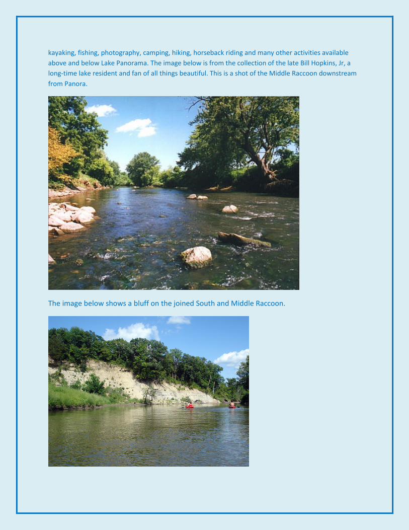
kayaking, fishing, photography, camping, hiking, horseback riding and many other activities available above and below Lake Panorama. The image below is from the collection of the late Bill Hopkins, Jr, a long-time lake resident and fan of all things beautiful. This is a shot of the Middle Raccoon downstream from Panora.
The image below shows a bluff on the joined South and Middle Raccoon.

The Prompt’s next feature will be on some of the environmental information about the Middle Raccoon.
February--March
Sun Mon Tue Wed Thu Fri Sat 3 4 5 6
7
50th anniversary
of classic advertising
8 9 10 11 12 13 Valentines
Eve…
14
♡ 15 16 17 18 19 20
21 22 23
NO Board
Meeting until
March 22
24 25 26 27
28 29 March1 2 3 4 5