feasibility studies unit program development … study i-40/us 64 ... burkemont avenue connects with...
TRANSCRIPT

Feasibility Study
I-40/US 64 (Exit 103) Interchange Reconstruction
City of Morganton, Burke County
Division 13 FS-0513B
Feasibility Studies Unit Program Development Branch
N.C. Department of Transportation
Documentation Prepared by Ko & Associates, P.C.
Mark L. Reep, P.E. Derrick W. Lewis, P.E. Project Manager Feasibility Studies Unit Head
Ko & Associates, P.C. Feasibility Studies Unit, NCDOT
Nicole M. Hackler, P.E. Feasibility Studies Engineer Feasibility Studies Unit, NCDOT
Date
FS-0513B
I-40/US 64 (Exit 103) Interchange Reconstruction
City of Morganton, Burke County
Division 13
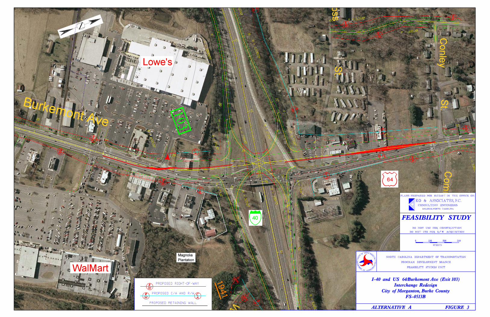
I. General Description This feasibility study addresses the proposed interchange improvements to I-40/US 64 (Exit 103) in the City of Morganton in Burke County (see Figure 1). The proposed improvements include reconstructing the interchange to current design standards for a single point urban interchange (SPUI). The existing conventional diamond interchange includes a bridge carrying Burkemont Avenue (US 64) traffic over I-40. I-40 is a four-lane, median divided freeway, and Burkemont Avenue is a five-lane facility with curbs and gutters in the vicinity of the interchange. The existing right of way width for I-40 in the vicinity of Exit 103 varies from approximately 250 to 600 feet, and the existing right of way width along Burkemont Avenue varies from approximately 60 to 100 feet. There is a continuous sidewalk along the east side of the roadway north of I-40 and sporadic locations with sidewalks south of I-40. Burkemont Avenue connects with West Union Street (US 70 Business) near the downtown area of Morganton north of Exit 103. South of the interchange, Burkemont Avenue travels through southwest Burke County and into rural northern Rutherford County. Exit 103 provides access to downtown Morganton, numerous commercial, industrial, and institutional developments as well as residential areas. The proposed SPUI includes a new alignment and bridge located to the west of the current location (see Figures 2 and 3). Burkemont Avenue will have six continuous through lanes and auxiliary lanes that are added or dropped in various locations with curbs and gutters throughout. All lanes will be 12 feet wide. The proposed bridge will be designed to accommodate eight through lanes (plus turn lanes) on Burkemont Avenue and will be long enough to allow sufficient room for future widening of I-40 to eight 12-foot lanes with a 22-foot median. Full control of access is proposed within the interchange and along Burkemont Avenue in the vicinity of the interchange. As a consequence, Ross Street will be realigned to provide access beyond the area of full control of access. This study is the initial step in the planning and design process for this project and is not the product of exhaustive environmental or design investigations. The purpose of this study is to describe the proposed project, including costs, and to identify potential problems that may require consideration in the planning and design phases.
1
II. Background and Need for Project The purpose of this project is to reconstruct Exit 103 to provide improved traffic safety and operations. The existing five lanes along Burkemont Avenue do not adequately handle the current traffic volumes, and the closely spaced traffic signals at the ramp terminals only exacerbate the congestion problems. With the amount of congestion, particularly during peak hours, it is often difficult for traffic moving between Burkemont Avenue and I-40 to maintain constant flow. Traffic on the westbound exit ramp frequently backs up onto I-40. A reconfiguration of the interchange and additional lanes along Burkemont Avenue at Exit 103 will increase the traffic carrying capacity of the facility. Functional classifications were obtained from NCDOT’s Urban Functional Classification Maps, the Greater Hickory Metropolitan Planning Organization (February 14, 2006), and the Greater Hickory Urban Area Transportation Plan (September 2005). According to these sources, Burkemont Avenue is classified as a principal arterial, and Williams Road (SR 1941), Ross Street, Community College Road (SR 2013), and Conley Street are all classified as local roads. City of Morganton, Burke County, and Unifour Rural Planning Organization (RPO) officials support this project. The conclusions of the Unifour RPO’s I-40 Corridor Study (adopted December 2003) ranked improvements to Exit 103 in Burke County as the fourth highest priority need. I-40 has two 24-foot travel ways in each direction, a 30-foot median, four-foot paved median shoulders, 12-foot paved outside shoulders, and a 300-foot right of way width. The posted speed limit is 65 miles per hour (mph). All ramps are single-lane ramps. The I-40 exit ramps widen at the Burkemont Avenue intersections to accommodate right and left turn lanes. Burkemont Avenue is 64 feet wide from face to face of curbs, has an approximate five-foot sidewalk in selected locations, and is contained within a 100-foot right of way. The posted speed limit is 45 mph. Traffic signals exist at the intersections with Community College Road (SR 2013)/Conley Street, the I-40 ramp terminals, and the entrances to the Lowe’s and Wal-Mart shopping centers. Ross Street and Williams Road are two-lane residential streets that intersect with the project and are controlled by stop signs. Ross Street intersects with Burkemont Avenue just north of I-40. Williams Road intersects with the eastbound I-40 on-ramp approximately 300 feet east of Burkemont Avenue. Two-way traffic is maintained in this short distance between the two intersections. The existing bridge (Bridge No. 25) was built in 1957 and is a 213-foot long, 64-foot wide reinforced concrete deck girder structure. It carries four lanes with a center turn lane over I-40, has three-foot sidewalks on both sides, and a minimum vertical clearance of just over 15 feet. According to the most recent inspection report (June 20, 2006), the
2
bridge has a sufficiency rating of 81.2 and evaluation codes for the deck, superstructure, and substructure in the “good” range. Based on site visit observations, existing land uses adjacent to Exit 103 include commercial, industrial and institutional developments along with residential and utility uses. Commercial development is the prevalent land use along Burkemont Avenue in the vicinity of the interchange including a Wal-Mart store, a Lowe’s home improvement center, fast-food restaurants, convenience store/gas stations, and hotels. There is also a large Duke Power sub-station at the Western Piedmont Community College campus in the northeast quadrant of the interchange, and the historic Magnolia Plantation in the southeast quadrant of the interchange. Further away from the interchange, Burkemont Avenue serves primarily residential land uses north of I-40 and commercial and industrial land uses south of I-40. According to a map depicting land uses in the I-40 Corridor Study, land uses surrounding Exit 103 are mostly commercial and office/institutional along and east of Burkemont Avenue with residential and industrial uses west of Burkemont Avenue. There are no programmed projects in the 2007-2013 State Transportation Improvement Program (TIP) in the general vicinity of this project that would affect the alternatives developed for this study. However, TIP U-2551 proposes to widen Enola Road (SR 1922/SR 1924) and upgrade the interchange at Exit 104, which is approximately one mile east of Exit 103.
III. Traffic and Safety
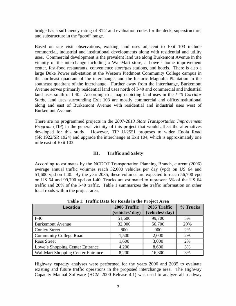
According to estimates by the NCDOT Transportation Planning Branch, current (2006) average annual traffic volumes reach 32,000 vehicles per day (vpd) on US 64 and 51,600 vpd on I-40. By the year 2035, these volumes are expected to reach 56,700 vpd on US 64 and 99,700 vpd on I-40. Trucks are estimated to represent 5% of the US 64 traffic and 20% of the I-40 traffic. Table 1 summarizes the traffic information on other local roads within the project area.
Table 1: Traffic Data for Roads in the Project Area Location 2006 Traffic
(vehicles/ day)2035 Traffic
(vehicles/ day) % Trucks
I-40 51,600 99,700 5% Burkemont Avenue 32,000 56,700 20% Conley Street 800 900 2% Community College Road 1,500 2,000 2% Ross Street 1,600 3,000 2% Lowe’s Shopping Center Entrance 4,200 8,600 3% Wal-Mart Shopping Center Entrance 8,200 16,800 3% Highway capacity analyses were performed for the years 2006 and 2035 to evaluate existing and future traffic operations in the proposed interchange area. The Highway Capacity Manual Software (HCM 2000 Release 4.1) was used to analyze all roadway
3

segments, entrance and exit ramp junctions, and stop-sign controlled intersections. Synchro 5.0 and SimTraffic were used to analyze and simulate all intersections with traffic signals (signalized intersections). Traffic operating conditions are measured using levels of service (LOS) represented by a letter designation from A to F. LOS A represents the best operating conditions and LOS F the worst. LOS D is generally considered to be acceptable in urban areas. LOS E designates conditions in which a facility reaches its traffic carrying capacity, and LOS F represents a breakdown in traffic flow. Existing Traffic Conditions and No-Build Alternative Capacity analyses of intersections and freeway ramp junctions in the project area were performed for current (2006) and future (2035) no-build conditions. Traffic signals exist at the Burkemont Avenue intersections with Community College Road/Conley Street, the I-40 northern and southern ramps, and the Lowe’s/Wal-Mart shopping center entrance. The Community College Road/Conley Street intersection currently operates at LOS A, and it will operate at LOS B by the year 2035. The northern and southern I-40 ramp intersections currently operate at LOS D and LOS B, respectively, and by the year 2035, these intersections will operate at LOS F. The Lowe’s/Wal-Mart intersection currently operates at LOS B, and by the year 2035 it will operate at LOS F. The Ross Street intersection is unsignalized, and its current and future LOS is F. The I-40 ramp junctions currently function at LOS C or better, and the ramps will reach LOS F by the design year. See Table 2 for details. Table 2: Summary of Levels of Service (LOS) for Existing and No Build Conditions
Facility Description 2006 Existing Condition 2035 No Build Condition
Intersections with Traffic Signals LOS/ Delay
(seconds /vehicle) LOS/ Delay
(seconds /vehicle) I-40 Ramp Terminals
Northern Intersection D / 43 F / 214 Southern Intersection B / 16 F / 155
Community College Rd/ Conley St A / 4 B / 15 Lowe’s/Wal-Mart Entrance B / 20 F / 132
Unsignalized Intersections LOS LOS Ross Street F F
Ramp Junctions LOS LOS I-40 Eastbound On-Ramp C F I-40 Eastbound Off-Ramp B F I-40 Westbound On-Ramp C F I-40 Westbound Off-Ramp C F
4

5
Proposed Traffic Considerations Capacity analyses were performed to determine the future operating conditions for two interchange design concepts – a single point urban interchange (SPUI) and a compressed diamond interchange. The intersections with Community College Road/Conley Street and the Lowe’s/Wal-Mart shopping center entrance were also included. Two primary factors influence the intersection levels of service: the number of left-turn lanes on the westbound I-40 off-ramp and the number of through lanes planned on Burkemont Avenue. For each interchange design concept, Burkemont Avenue was analyzed as a four-lane, six-lane, and eight-lane road. The I-40 westbound off-ramp was analyzed with two and three left turn lanes at its intersection with Burkemont Avenue. The results of traffic operations are summarized in Table 3. Single Point Urban Interchange The SPUI design directs all of the ramp terminals into a single intersection with Burkemont Avenue to replace the two existing intersections. This single point intersection will operate at LOS F in the year 2035 under all widening conditions that were studied. However, the average delay per vehicle is substantially reduced if at least six through lanes are constructed on Burkemont Avenue and three left turn lanes are added to the I-40 westbound ramp. Also, if Burkemont Avenue is widened to at least six lanes, the Community College Road/Conley Street intersection will operate at LOS A, and the intersection with the Lowe’s/Wal-Mart entrance will operate at LOS E with turn lane improvements. The single intersection point provides the most efficient design by reducing the overall delays within the project area. Compressed Diamond Interchange The compressed diamond configuration retains two intersections with traffic signals at the I-40 ramps, similar to the existing conditions. With at least six through lanes on Burkemont Avenue, the southern ramp intersection will operate at LOS D and the northern ramp intersection will operate at LOS F in the year 2035. The average delay per vehicle is substantially reduced at the northern ramp intersection if three left turn lanes are added to the I-40 westbound ramp. Also, if Burkemont Avenue is widened to at least six lanes, the Community College Road/Conley Street intersection will operate at LOS A, and the intersection with the Lowe’s/Wal-Mart entrance will operate at LOS F. Average travel times on Burkemont Avenue through the interchange would be 50 percent longer with a compressed diamond configuration as opposed to a SPUI. Ramp Junctions If I-40 remains as a four-lane facility through the year 2035, all reconstructed ramp junctions will operate at LOS F, but the new ramps would allow higher speeds and safer movements at the entrances and exits. If I-40 is to be ultimately widened to eight-lanes, the ramp junctions will operate at LOS A.

Single Point Urban Interchange Compressed Diamond Interchange 2 Left-Turn Lanes on Westbound Off-Ramp
3 Left-Turn Lanes on Westbound Off-Ramp
2 Left-Turn Lanes on Westbound Off-Ramp
3 Left-Turn Lanes on Westbound Off-Ramp Facility Description
4 Lanes US 64
6 Lanes US 64
8 Lanes US 64
4 Lanes US 64
6 Lanes US 64
8 Lanes US 64
4 Lanes US 64
6 Lanes US 64
8 Lanes US 64
4 Lanes US 64
6 Lanes US 64
8 Lanes US 64
Intersections with Traffic Signals
LOS/ Delay (seconds /vehicle)
LOS/ Delay (seconds /vehicle)
LOS/ Delay (seconds /vehicle)
LOS/ Delay (seconds /vehicle)
I-40 Ramp Terminal(s) Northern -- -- -- -- -- -- F / 119 F / 106 F / 106 F / 98 F / 84 F / 84 Single Point F / 135 F / 125 F / 125 F / 100 F / 90 F / 90 -- -- -- -- -- --Southern -- -- -- -- -- -- E / 69 D / 49 D / 51 E / 69 D / 53 D / 54
Community College Rd/ Conley St C / 30 A / 7 A / 7 C / 30 A / 7 A / 7 B / 15 A / 5 A / 5 B / 19 A / 5 A / 5 Lowe’s/Wal-Mart Entrance
Southbound Single Left F / 92 F / 97 F / 96 F / 92 F / 96 F / 96 F / 128 F / 112 F / 111 F / 128 F / 112 F / 110 Southbound Double Left E / 78 E / 74 E / 74 E / 78 E / 74 E / 74 F / 116 F / 98 F / 96 F / 116 F / 98 F / 96
LOS LOS LOS LOS Ramp Junctions (4 Lanes I-40) (8 Lanes I-40) (4 Lanes I-40) (8 Lanes I-40) (4 Lanes I-40) (8 Lanes I-40) (4 Lanes I-40) (8 Lanes I-40)
I-40 Ramp Junctions Eastbound On-Ramp F A F A F A F A Eastbound Off-Ramp F A F A F A F A Westbound On-Ramp F A F A F A F A
Westbound Off-Ramp F A F A F A F A
Table 3: Summary of 2035 Levels of Service (LOS) for Build Conditions
6
Crash Analysis Between July 1, 2003 and June 30, 2006 there were 187 reported crashes at Exit 103 – zero fatal, 64 non-fatal, and 123 property damage only crashes. The crash rate is 601.20 crashes per 100 million vehicle miles traveled, which is well above the 2003-2005 statewide crash rate of 479.04 crashes per 100 million vehicle miles traveled for urban four-lane undivided primary routes. With the proposed SPUI in place, the traffic operations should improve in this area and reduce the likelihood of crashes.
IV. Description of Alternative Only a SPUI alternative was fully evaluated for this Feasibility Study since the compressed diamond interchange concept would cause significantly worse overall traffic delays within the project area. The preliminary conceptual designs for the SPUI include six through lanes, auxiliary lanes that are added or dropped at various locations, curbs and gutters throughout, and sidewalks in some areas with a right of way width that varies from approximately 110 to 330 feet. The proposed bridge will be located approximately 100 feet west of the existing structure to enable phased construction and to reduce impacts to the power sub-station and historic site. It will carry six through lanes of traffic along with two left turn lanes in each direction and sidewalks on both sides that will be five and a half feet wide. All lanes for this project will be 12 feet wide. Curbs and gutters that measure two and a half feet wide are proposed along both sides of Burkemont Avenue for the length of the project. The proposed bridge will be designed to ultimately accommodate eight lanes of through traffic along Burkemont Avenue and long enough to span eight 12-foot lanes and a 22-foot wide median along I-40. A concrete median varying in width from between four and 28 feet will be located along Burkemont Avenue from the Conley Street/Community College Road intersection to the entrances for Wal-Mart and Lowe’s with the exception of the interchange area. Since U-2551 (widening Enola Road with improvements to Exit 104) is in close proximity to Exit 103 (approximately one mile), the preliminary conceptual design of the SPUI alternative included auxiliary lanes in both the eastbound and westbound directions of I-40 between the two exits (see Figure 2). It was assumed half of the cost of these auxiliary lanes would be included in FS-0513B and the remaining half would be included in the cost of U-2551. For the studied alternative, the eastbound I-40 off-ramp begins as one lane and ultimately widens to four lanes – two lanes for traffic traveling north along Burkemont Avenue and two lanes for traffic traveling south. The westbound I-40 off-ramp begins as one lane and widens to four lanes with one lane for northbound Burkemont Avenue and three lanes for southbound traffic. The eastbound I-40 on-ramp includes one lane from northbound Burkemont Avenue merging into two lanes from southbound Burkemont Avenue that ultimately decreases to the 12-foot wide auxiliary lane. The westbound I-40 on-ramp has one lane of southbound Burkemont Avenue merging into two lanes of northbound Burkemont Avenue.
7
The entrances to the Wal-Mart and Lowe’s shopping centers from Burkemont Avenue will be improved as part of this project. Access will be full control in the vicinity of the interchange. Along the east side of Burkemont Avenue full control of access will extend from approximately 400 feet south of Community College Road to 250 feet south of the northbound Burkemont Avenue/eastbound I-40 on-ramp. Along the west side of Burkemont Avenue full control of access will extend from Conley Street to approximately 300 feet south of the southbound Burkemont Avenue/eastbound I-40 off-ramp. A cul-de-sac will be constructed along Williams Road, cutting off access from the eastbound I-40 on-ramp. Williams Road users will have access to Burkemont Avenue via Walker Road (SR 1942) south of the project area (see Figure 1). As a result of the proposed full control of access limits, Ross Street will be realigned to connect to Conley Street – taking advantage of the signalized Conley Street/Community College Road/Burkemont Avenue intersection for access. The right of way widths vary from approximately 120 to 320 feet along Burkemont Avenue, and between 300 and 650 feet along I-40. The proposed right of way along the realigned Ross Street varies between 80 and 130 feet. It is anticipated that the studied alternative will require no residential relocations and 11 business relocations. The estimated costs include $27,300,000 for construction and $18,400,000 for right of way for a total cost of $45,700,000. Other design concepts considered during this studied but not investigated further include:
• An alternative similar to the studied alternative that includes realigning Williams Road to connect to Burkemont Avenue approximately 600 feet south of the proposed interchange (see Figure 4);
• A SPUI with eight through lanes along Burkemont Avenue; • Designing the interchange as a compressed diamond, and; • A compressed diamond interchange with a flyover ramp between westbound I-40
and Burkemont Avenue. Realigning Williams Road is not being considered due to possible future development expansion plans by Wal-Mart and would add an additional $1,400,000 to the cost of the SPUI alternative ($1,000,000 for construction and $400,000 for right of way). Designing the interchange to accommodate eight through lanes would require improvements along Burkemont Avenue outside the limits of the scope of this project. As explained in the “Traffic and Safety” section of this document, a compressed diamond interchange alternative would not provide for optimal traffic flow. A compressed diamond interchange with a flyover ramp alternative was not considered due to the existing development in the vicinity of the project area and the associated high cost.
8
V. Community Issues
• Magnolia Place is located in the southeastern quadrant of the existing interchange and is on the State Historic Preservation Office’s (SHPO) National Register as a historic property. It is adjacent to the eastbound I-40 on-ramp (see Figures 2 and 3).
• Duke Power’s Breeden Switching Station (power sub-station) is located in the northeastern quadrant of the existing interchange and is adjacent to the existing westbound I-40 off-ramp.
• The campus of Western Piedmont Community College (WPCC) covers 330 acres and the main entrance is approximately 1,000 feet north of the existing interchange along Burkemont Avenue (see Figure 2). WPCC has a student enrollment of almost 3,000 students.
• The area served by Exit 103 is an important commercial and institutional hub for the City of Morganton and Burke County. In addition to the commercial development (including Wal-Mart and Lowe’s) and WPCC, the North Carolina School for the Deaf is located approximately three-quarters of a mile north of I-40 on the east side of Burkemont Avenue. With Exit 103 providing the main access to all of these facilities, this area is a destination for many people.
• A review of the Burke County Strategic Plan, 2002 gives no indication of potential environmental justice issues associated with this project, nor did site visit observations reveal any environmental justice issues.
VI. Natural Environment Issues
A detailed environmental study was not conducted for this feasibility study, however an environmental screening did find the following items which may need further evaluation in later planning and design stages:
• Protected Species – A search was conducted using the database from the North Carolina National Heritage Program for the Morganton South quadrangle (updated March 1, 2007). This search revealed no federally protected species. The plant species, Sweet Pinesap and Carolina Saxifrage are listed as a “Federal Species of Concern.”
• Wetlands – Based on a search of the National Wetland Inventory using geographical information systems (GIS), no wetlands will be affected by this project.
• Streams – This project will not involve the crossing of any streams. • Hazardous Materials Sites, Superfund Sites, and Underground Storage Tanks –
Based on a search performed by Environmental Data Resources, Inc., there are two hazardous materials sites, no superfund sites, and one underground storage tank within approximately ¼ mile of Exit 103. The two hazardous materials sites are Paramount Honda of Morganton located at 1600 Burkemont Avenue and Southern Convenience Store at 1022 Burkemont Avenue.
9

VII. Recommendations The SPUI alternative is recommended for this project and is estimated to cost $45,700,000 for right of way and construction. With the amount of development in this area, this concept will provide for more efficient traffic flows than a compressed diamond interchange. Furthermore, because of development, the community college, the sub-station, and the historic property, other design concepts would require substantially more right of way, and have greater impacts on these facilities. Cutting off access between Williams Road and Burkemont Avenue by constructing a cul-de-sac and re-routing Williams Road traffic to Burkemont Avenue via Walker Road eliminates the two-way traffic condition on the existing eastbound I-40 on-ramp further improving traffic conditions, and if Burkemont Avenue is widened in the future to eight through lanes, the proposed structure will be wide enough to accommodate the additional lanes.
10

FS-0513B
To Hickory
Morganton
Begin Project
End Project
^ Western PiedmontCommunity College
§̈¦40
SR 2013 (CommunityCollege Drive)
£¤64
Burkem
ont Road
Southern Railroad
Hunti
ng Cr
eek
£¤70 £¤64 £¤70BYP
£¤70BUS
West Fleming Drive
Union Street
SR 1007 (Hopewell Road)
Conley Street
Ross Street
^Lowe's ^Walmart
SR 1941 (Williams Road)
Catawba RiverSil
ver C
reek
To Asheville
Exit103
Exit104
SR 1942 (Walker Road)
^Asheville
Winston-Salem Greensboro
Charlotte
Raleigh
Fayetteville
WilmingtonNorth Carolina CountiesBurke County
±Morganton
BurkeCounty
ValdeseHickory
Conover/Newton
Lenoir
Marion
CaldwellCounty
AveryCounty
CatawbaCounty
ClevelandCounty
McDowellCounty
Rutherford County Lincoln County
§̈¦40 FS-0513B
0 1,500 3,000 Feet
Figure 1
Project Vicinity MapFS-0513B
I-40 and US 64/Burkemont Ave (Exit 103)Interchange Redesign
City of Morganton, Burke County
STATE OF NORTH CAROLINADEPARTMENT OF TRANSPORTATIONPROGRAM DEVELOPMENT BRANCHFEASIBILITY STUDIES UNIT