feasibility report town of silt to coal ridge high...
TRANSCRIPT

Feasibility Report Town of Silt to Coal Ridge High
School Bike Pedestrian Trail US 6
CDOT Project No. C 0063-017
Code: 15132
Prepared for:
Colorado Department of
Transportation and Town of Silt
Prepared by:
James E. Patton, PE/PLS Short Elliott Hendrickson, Inc.
Feasibility Report A-CODOT0501.00 Colorado Department of Transportation Page 2
May 12, 2005 RE: Feasibility Report – Town of
Silt to Coal Ridge High School Bike Pedestrian Trail
SEH No. ACODOT0501.00 Mr. Jim Nall Region 3 Traffic Engineer Colorado Department of Transportation 222 South 6th Street Grand Junction, CO 81501 Dear Mr. Nall: Short, Elliott Hendrickson Inc. (SEH®) is pleased to present the Feasibility Report for the project referenced above. The report provides a comparison of the advantages, disadvantages and costs for three feasible design alternates that were considered for this study. Alternate One with Option 2 at Davis Point was selected as the preferred alternate. Alternate One provides the most separation of pedestrian bicycle traffic from the vehicular traffic on US 6 making it the safest alternate. Safety was a primary goal of the feasibility study. Thank you for giving us the opportunity to provide this feasibility report to you. If you have questions or wish to discuss this further please call. Sincerely, SHORT ELLIOTT HENDRICKSON INC. James Patton, PE, PLS Project Manager JEP/jp cc: Owen Leonard File
Feasibility Report A-CODOT0501.00 Colorado Department of Transportation Page 3
CERTIFICATION PAGE
FEASIBILITY REPORT
TOWN OF SILT TO COAL RIDGE HIGH SCHOOL BIKE PEDESTRIAN TRAIL
SEH No. A-CODOT0501.01
CDOT Project No. C 0063-017
Code: 15132
May 12, 2005
I hereby certify that this feasibility report was prepared by me or under my direct supervision, and that I am a duly registered Professional Engineer with the State of Colorado. James E. Patton, PE/PLS Reg. No. 11671
Reviewed by: Owen Leonard, PE May 12, 2005
Short Elliott Hendrickon Inc. Bank of Colorado Building, Suite 202 200 Grand Avenue Grand Junction, CO 81501
Feasibility Report A-CODOT0501.00 Colorado Department of Transportation Page 4
TABLE OF CONTENTS Letter of Transmittal Certification Page ………………………………………………………………………. 3 Table of Contents ………………………………………………………………………. 4-5 Abstract …………………………………………………………………………………. 6 Project Location ………………………………………………………………………… 6 Project Scope – Introduction …………………………………………………………… 7 Existing Conditions …………………………………………………………………….. 8-11
ROW Accident History County Road 235 – Davis Point Road Topographic Constraints Irrigation, Drainage and Utilities Wetlands
Design Criteria ………………………………………………………………………….. 11-12 Design Guidelines
Materials Recommendations Study Approach …………………………………………………………………………. 12-14
Constraints Topographic Design
Segments Options at Davis Point
Option 1 Option 2 Disadvantages/Advantages of Options
Cost Estimates CBC Extensions Vs. Bridge
Alternates Considered …………………………………………………………………… 14-17 Alternate One
Description Typical Section Layout Drawing Advantages and Disadvantages Engineering Cost Estimate
Alternate Two Description Typical Section Layout Drawing Advantages and Disadvantages Engineering Cost Estimate
Alternate Three Description Typical Section Layout Drawing Advantages and Disadvantages Engineering Cost Estimate
Summary of Alternates Conclusion and Recommended Alternate ………………………………………………. 17-18

Feasibility Report A-CODOT0501.00 Colorado Department of Transportation Page 5
List of Tables
Table 1 Summary of Alternate Construction Costs Table 2 Summary of Advantages and Disadvantages
List of Figures
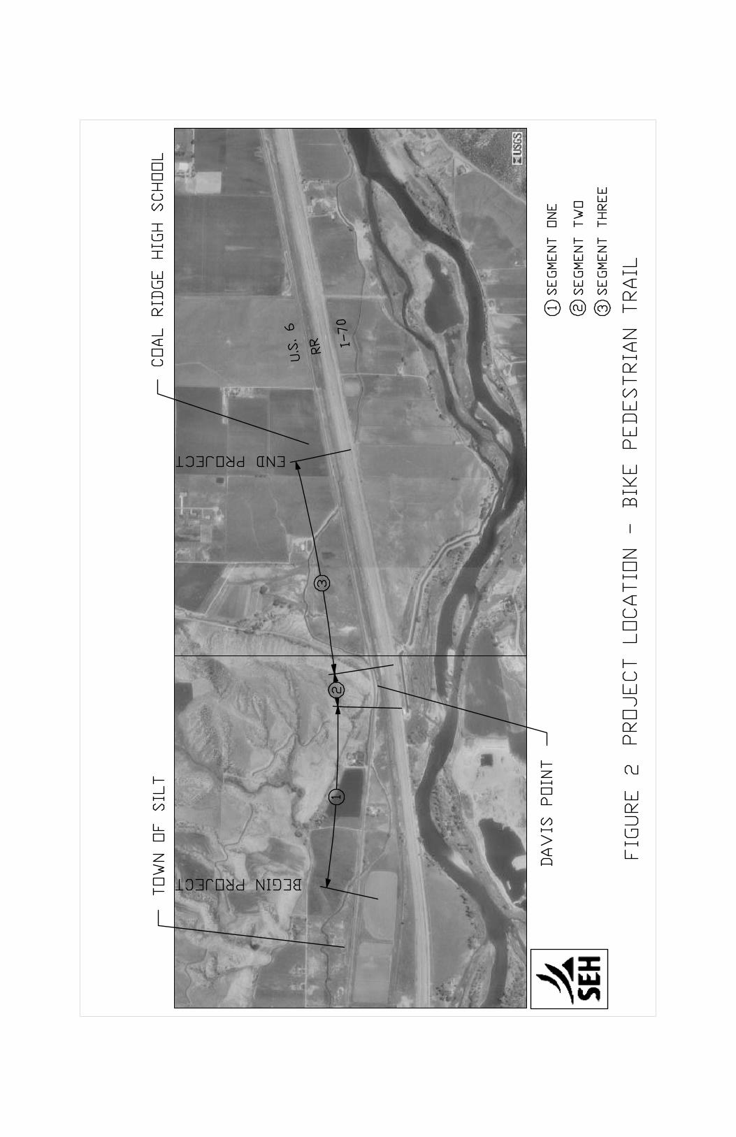
Figure 1 Topographic Map of Project Location Figure 2 Project Location – Bike Pedestrian Trail
List of Photos
Photo 1 North side of US 6 viewing east toward Davis Point. Photo 2 Double Cell 6’ x 4’ Concrete Box Culvert – Lower Cactus Valley Ditch Photo 3 Lower Cactus Valley Ditch between CBCs 2 and 3 viewing west Photo 4 Double Cell 6’ x 4’ CBC at the outlet west of Davis Point Photo 5 Big “R” Truss Bridge Design Photo 6 Coal Ridge High School under construction near end of bike pedestrian trail
List of Typical Sections
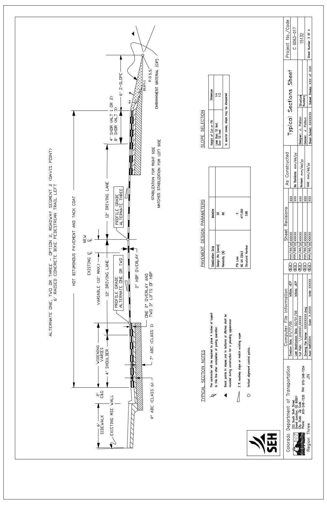
Sheet 1 Alternate One – Segments 1 and 3, Alternate Two – Segment 1; Alternate One - Wetlands Areas Sheet 2 Alternates One or Two – Option 1, Roadway Segment 2 (Davis Point) Sheet 3 Alternates One, Two or Three – Option 2, Roadway Segment 2 (Davis Point) Sheet 4 Alternate Two – Segment 3 Alternate Three – Segments 1 and 3
List of Layout Drawings Drawing 1 Alternate One – Project Location Bike Pedestrian Trail Drawing 2 Alternate Two – Project Location Bike Pedestrian Trail Drawing 3 Alternate Three – Project Location Bike Pedestrian Trail
List of Cost Estimates
Estimate 1 Alternates 1 or 2, Roadway Segment 1 (Silt to Davis Point) Estimate 2 Alternate 3, Roadway Segment 1 (Silt to Davis Point) Estimate 3 Alternates 1 or 2, Option 1, Roadway Segment 2 (Davis Point) Estimate 4 Alternates 1, 2, or 3, Option 2, Roadway Segment 2 (Davis Point) Estimate 5 Alternate 1, Roadway Segment 3 (Davis Point to Coal Ridge High School) Estimate 6 Alternate 2, Roadway Segment 3 (Davis Point to Coal Ridge High School) Estimate 7 Alternate 3, Roadway Segment 3 (Davis Point to Coal Ridge High School) Wetlands Walkway Cost Estimate – Schmueser, Gordon and Meyer Engineers & Surveyors
List of Appendices
Appendix A 5-Year Analysis of US 6 Accident History Appendix B CDOT 2002 Accident and Rates Appendix C 2002 Average Daily Traffic Volume – County Road 235 (Davis Point Road) Appendix D Materials Recommendation Letter

Feasibility Report A-CODOT0501.00 Colorado Department of Transportation Page 6
Abstract Comparison of the advantages, disadvantages and costs for three feasible design alternates were considered for this study. Alternate One with Option 2 at Davis Point was selected as the preferred alternate. This alternate provides two methods for crossing wetlands areas. Alternate One provides the most separation of pedestrian bicycle traffic from the vehicular traffic on US 6 making it the safest alternate. Safety was a primary goal of the feasibility study. Project Location This feasibility report is for a proposed bike pedestrian trail that connects on the west end with an existing trail termini near the east town boundary of Silt, Colorado in Garfield County. The proposed trail extends this existing trail East along US 6 to the Coal Ridge High School scheduled to open in the fall of 2005. The existing trail termini is near Mile Marker 100 on US 6 on the north side of the roadway. Project length is about 6,400 feet or 1.2 miles. Figure 1 is a topographic map of the project location.
FIGURE 1 – Topographic Map of Project Location

Feasibility Report A-CODOT0501.00 Colorado Department of Transportation Page 7
Project Scope - Introduction The Colorado Department of Transportation Region 3 (CDOT R3) requested that Short Elliott Hendrickson Inc. (SEH) prepare a feasibility report for providing a bike pedestrian trail along US 6 from the Town of Silt east to Coal Ridge High School. This feasibility report compares favorability (i.e., advantages and disadvantages) and costs for three alternate preliminary design concepts. The primary purpose of this trail is to provide safe pedestrian and bicycle non-motorized access from Silt to Coal Ridge High School. Recreational use is secondary to safety for this trail. The feasibility report identifies potential environmental, utility, irrigation and other impacts that affect the design. All alternates will require additional right-of-way. An estimate of additional right-of-way needs is made for each alternate. Other important project stakeholders include the Town of Silt, Town of New Castle and Garfield County School District RE-2. Representatives from the Town of Silt participated in the development of this report.
Photo 1 - North side of US 6 viewing east toward Davis Point.
Feasibility Report A-CODOT0501.00 Colorado Department of Transportation Page 8
Existing Conditions Following the project kickoff meeting, SEH gathered information regarding the US 6 corridor that was necessary for evaluating the alternate design concepts for the bike pedestrian trail. A minimal field survey was necessary to determine potential alternates and their costs. Below is information gathered that will affect the design of the bike pedestrian trail:
1. Right-of-Way. Jay Janney with CDOT R3 Right-of-Way provided as-constructed plans of US 6 from CDOT Project No. F 001-1(19) and ROW maps in the area east of Silt from CDOT Project FAP 145-C. Generally the ROW is 50 feet each side of US 6 center line. Exceptions are at Davis Point where the ROW on the north side of US 6 expands to 70 feet for approximately 1900 feet and approximately 2500 ft. west of the Coal Ridge High School the ROW on the north side contracts to 40 feet. Additional right-of-way would be required for each of the alternates.
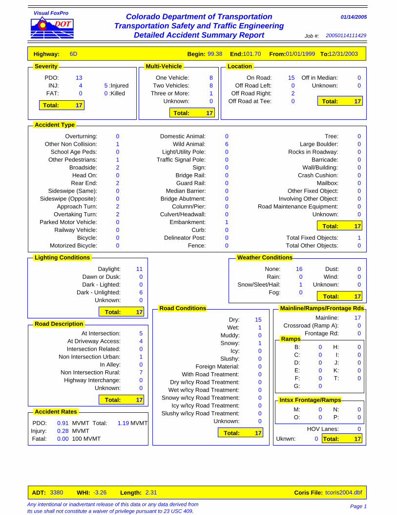
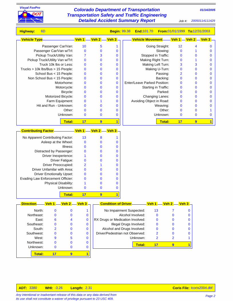
2. Accident History for US 6. Hans Egghart with CDOT R3 Traffic provided a five-year analysis of accident history. This analysis is included in Appendix A. The CDOT Statewide average crash rates for 2002 are also included in Appendix A. The accident history provided is for 2.3 miles on US 6 from Mile Marker 99.38 to Mile Marker 101.70. This project is 1.2 miles within these limits. The five-year weighted hazard index is -3.26 which is well below the State average of 1.56 for Federal Aid Primary Rural. There were seventeen accidents within this five-year period. Slightly less that half of these accidents occurred at roadway or driveway intersections. Six of these accidents involved collisions with wild animals. Most accidents occurred under good weather conditions during hours of daylight. Since most accidents happened at intersections it is important the bike pedestrian trail cross roadways at safe locations with good sight distance. It is important for safety of the pedestrian and bicyclist that points of conflict with motorists be minimized.
3. County Road 235 – Davis Point Road. This intersection with US 6 is east of Davis Point. Sight distance at the intersection is limited to the west of the intersection. The 2002 Average Daily Traffic is 307 according to Jeff Nelson, Assistant County Engineer. Future development may take place to the north of this intersection. If so, consideration should be made for realigning the intersection for better sight distance.
4. Topographic Constraints. The primary topographic constraint is Davis Point. This prominent steep hillside combined with the location of the Lower Cactus Valley Ditch, Denver and Rio Grande Western Railroad and Interstate 70 limit options for the bike pedestrian trail for this section. Refer to Figure 1 (middle right) for a visual of this topographic constraint. Two options are available at this location and will be described in more detail later.
5. Irrigation, Drainage and Utilities. There is an irrigation ditch crossing of US 6 approximately 300 feet east of Mile Marker 100. This is the Lower Cactus Valley Ditch. The structure is a double 6’x 4’cell CBC skewed to US 6. Aerial
Feasibility Report A-CODOT0501.00 Colorado Department of Transportation Page 9
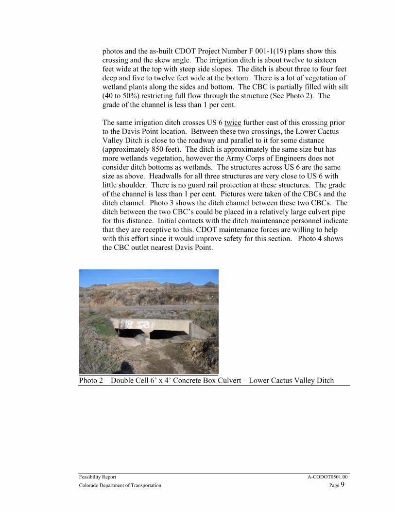
photos and the as-built CDOT Project Number F 001-1(19) plans show this crossing and the skew angle. The irrigation ditch is about twelve to sixteen feet wide at the top with steep side slopes. The ditch is about three to four feet deep and five to twelve feet wide at the bottom. There is a lot of vegetation of wetland plants along the sides and bottom. The CBC is partially filled with silt (40 to 50%) restricting full flow through the structure (See Photo 2). The grade of the channel is less than 1 per cent.
The same irrigation ditch crosses US 6 twice further east of this crossing prior to the Davis Point location. Between these two crossings, the Lower Cactus Valley Ditch is close to the roadway and parallel to it for some distance (approximately 850 feet). The ditch is approximately the same size but has more wetlands vegetation, however the Army Corps of Engineers does not consider ditch bottoms as wetlands. The structures across US 6 are the same size as above. Headwalls for all three structures are very close to US 6 with little shoulder. There is no guard rail protection at these structures. The grade of the channel is less than 1 per cent. Pictures were taken of the CBCs and the ditch channel. Photo 3 shows the ditch channel between these two CBCs. The ditch between the two CBC’s could be placed in a relatively large culvert pipe for this distance. Initial contacts with the ditch maintenance personnel indicate that they are receptive to this. CDOT maintenance forces are willing to help with this effort since it would improve safety for this section. Photo 4 shows the CBC outlet nearest Davis Point.
Photo 2 – Double Cell 6’ x 4’ Concrete Box Culvert – Lower Cactus Valley Ditch

Feasibility Report A-CODOT0501.00 Colorado Department of Transportation Page 10
Photo 3 – Lower Cactus Valley Ditch between CBCs 2 and 3 viewing west. Note: Wetlands in ditch bottom.
Photo 4 – Double Cell 6’ x 4’ CBC at the outlet west of Davis Point.
The fourth irrigation ditch crossing of US 6 is immediately east of the Davis Point Road intersection. This is also the Lower Cactus Valley Ditch. The ditch section and CBC are similar to those described previously.
The fifth irrigation ditch crossing of US 6 is at a private road off of US 6 to the
northwest. This road follows along the ditch to the northeast after it crosses the highway. Again, the ditch and CBC is a similar structure to the other crossings. This too is the Lower Cactus Valley Ditch.
The estimated capacity to the Lower Cactus Valley Ditch west of Davis Point is 30 to 40 cubic feet per second (cfs). The capacity flow of the double cell 6’x4’ CBCs with 40% silting is about 60 to 80 cfs at each crossing of US 6. Therefore, the CBCs are currently adequate for the ditch size even with the current silting condition.

Feasibility Report A-CODOT0501.00 Colorado Department of Transportation Page 11
There are a number of US 6 drainage cross culverts that range in size from 18-inch to 36-inch diameter. These are shown on the as-built plans named previously.
Utilities were not visibly prevalent. Further investigation will be required prior
to preliminary design with the field survey. It was noted that there is a railroad communication line along the tracks on the south of US 6. There are also a number of telephone pedestals at various locations on the north side of US 6 along the entire corridor. These are relatively close to the roadway. Utilities located within the CDOT right-of-way that need relocation would be moved at the owner’s expense according to Dwight Burgess, R3 Utilities Engineer. Utilities located outside of the CDOT right-of-way would be moved at CDOT or the local entity expense.
6. Wetlands. The definition of wetlands as used by the U.S. Army Corps of Engineers (Corps) and the U.S. Environmental Protection Agency (EPA) since the 1970s for regulatory purposes: "Wetlands are areas that are inundated or saturated by surface or ground water at a frequency and duration sufficient to support, and that under normal circumstances do support, a prevalence of vegetation typically adapted for life in saturated soil conditions. Wetlands generally include swamps, marshes, bogs, and similar areas." Wetlands are extensive along the entire corridor on both the north and south side of US 6.
It appears that all the alternates will have some impact on wetlands environments. West of Davis Point wetlands plants are primarily limited to the bottom of irrigation ditches. Generally, the Corps of Engineers has not required mitigation for these situations involving irrigation ditches. Mark Gilfillan with the Corps of Engineers - Grand Junction office (phone 970-243-1199 ext. 15) believes that the wetlands adjacent to US 6 east of Davis Point are caused primarily by high ground water which surfaces as it approaches US 6. Mr. Gilfillan said that even with selection of a preferred alternate with this report; he would want to review the wetlands impacts of the other alternates. If one of the other alternates has fewer wetlands impacts, then acceptable justification for the preferred alternate is needed. He said that impacts less than one half acre are covered under a nationwide permit.
Wetlands mitigation techniques cannot be made until preliminary design is undertaken. Field review of the areas impacted will need to be made. Preliminary field staking of the alignment may be necessary.
Design Criteria
1. Design for the alternate selected should be in accordance with American Association of State Highway and Transportation Officials publication entitled, Guide for the Development of Bicycle Facilities, 1999. This is a widely

Feasibility Report A-CODOT0501.00 Colorado Department of Transportation Page 12
accepted guide nationally and provides the best information that I have found for design criteria and considerations for development of the bikeways.
2. Another valuable source that should be used for the design should be the Colorado Department of Transportation Design Manual using the section regarding bikeways.
3. Materials Recommendations. Rex Goodrich with CDOT R3 Materials provided the materials recommendations for widening US 6 which is necessary for each of the alternates albeit for varied segment lengths and locations. Stabilization requirements for the widening of US 6 are: Hot Bituminous Pavement (Grading SX)(75) is 6 inches in two or three lifts, 4 inches of Aggregate Base Course (Class 6) for base and 7 inches of Aggregate Base Course (Class 1) for subbase. PG 76-28 asphalt shall be used for the top 2-inch layer of HBP and PG 64-28 asphalt shall be used for the bottom layers of HBP. The materials recommendations letter is included in Appendix C. Stabilization for the separated bike/pedestrian trail is 3 inches of HBP (Grading SX)(75) and 4 inches of ABC (Class 6) for base. This was not a recommendation from CDOT R3 Materials but is typical of stabilization used for a bike pedestrian facility. Additional stabilization is required for building upon wetlands areas.
Study Approach
1. Constraints. a. Topographic. Topographic constraints have been described previously
under “Existing Conditions”. The primary topographic constraint affecting design is Davis Point. Secondary topographic constraints affecting design are locations of the wetlands and irrigation crossings of the Lower Cactus Valley Ditch.
b. Design. Design standards for vertical and horizontal alignment of the trail will not be difficult to obtain with exception of the Davis Point location. Sight distance and grade may be difficult at this location. To obtain design criteria for grade alignment, the trail may need to be lengthened and temporarily misdirected in order to “chase grade”. Sight distance at Davis Point Road and US 6 is a problem now and will continue to be so.
2. Segments. The length of trail was divided into three segments for consideration of design features and costs. Segment 1 is west of Davis Point, Segment 2 is at Davis Point and Segment 3 is east of Davis Point. Figure 2 shows the beginning and end of the project and limits of the segments. These segments are also illustrated on the layout drawings for each alternate considered. These segments may be useful if the project is phased for construction in the future.
3. Options at Davis Point. Two options were considered at Davis Point: a. Option 1 is alignment of the bituminous surfaced 6 foot wide bike
pedestrian trail above the roadway mechanically stabilized earth (MSE) wall upon an existing bench. This alternate requires extension of the

Feasibility Report A-CODOT0501.00 Colorado Department of Transportation Page 13
roadway MSE wall as well as the MSE wall upslope. This option is shown in section on Typical Section Sheet 2. This option is viable with Alternate One or perhaps Alternate Two but not Alternate Three.
b. Option 2 is alignment of the bike pedestrian trail adjacent to the US 6 roadway and below the MSE wall. This section of the trail is a 6 foot concrete surfaced sidewalk. This option is shown in section on Typical Section Sheet 3. This option is viable for all three alternates.
c. Advantages/Disadvantages of Options. Option 1 moves trail traffic further from roadway vehicular traffic but has the disadvantage of increased grades and distances required meet design standards for maximum grade. The cost of Option 1 is greater. Option 2 requires less distance for the trail and is viable for all three alternates, however it places bike pedestrian traffic closer to the vehicular traffic. Another disadvantage is that it requires a shift to the south of the vehicular traffic for US 6 to accommodate the sidewalk section. Speeds for US 6 would need to be reduced to less than 45 mph due to the sidewalk curb.
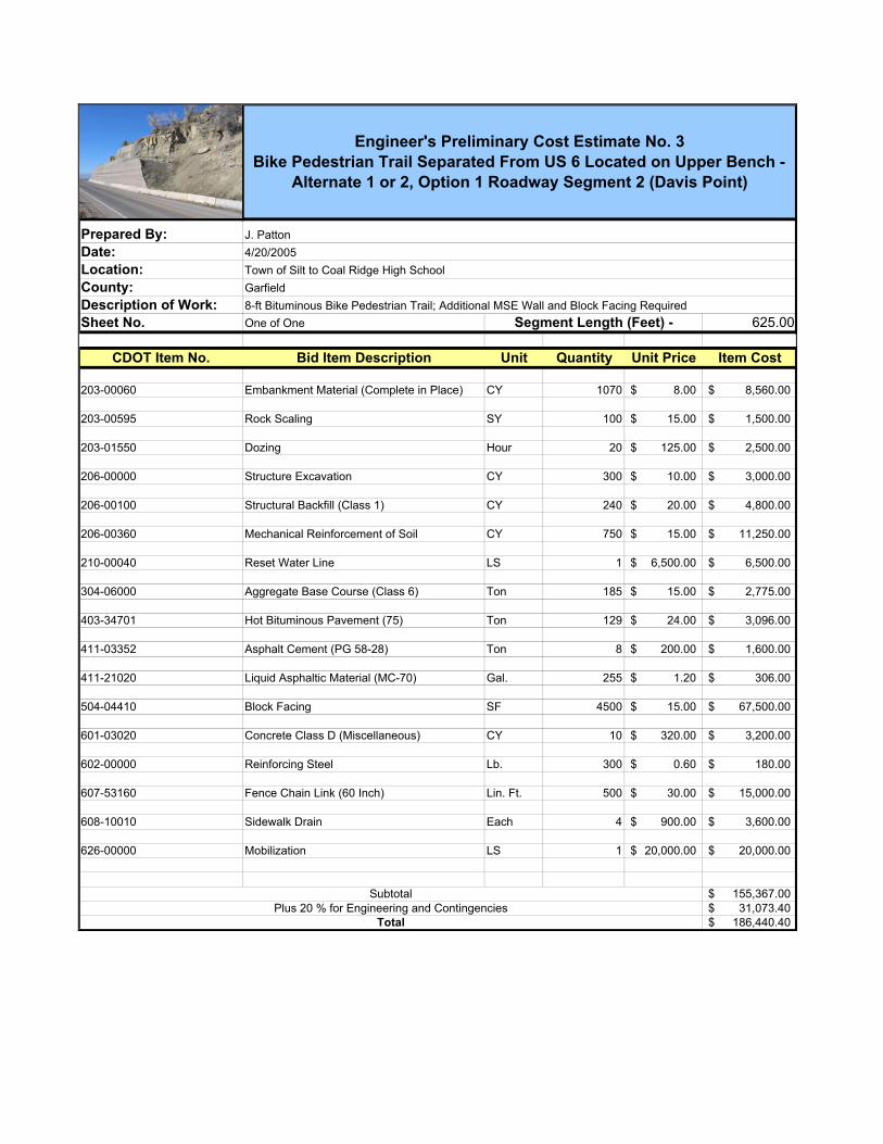
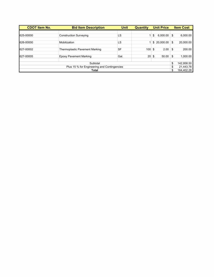
4. Cost Estimates. Cost estimates are preliminary based upon a minimal survey using present day costs of anticipated bid items. All estimates have the addition of at least 15 percent for construction engineering and contingency. The estimate for the separate alignment, that is Alternate One, has an addition of 20 percent for construction engineering and contingency due to higher risk in estimating accurate quantities. Likewise, Option 1 for Segment 2 has an addition of 20 percent for construction engineering and contingency due to higher risk in estimating accurate quantities. Although the cost estimates are preliminary, they are adequate for making comparative decisions regarding the feasibility of the alternates. Wetlands mitigation requirements could not be fully assessed at the time of this report. Therefore, costs could not be fully determined. Although a preferred alternate is selected with this study, it is recommended that further evaluation of the alternates be made during preliminary design based upon wetlands requirements and recommendations following a field review of the staked alignments by the Corps of Engineers. A wetlands walkway cost estimate was prepared by Schmueser, Gordon and Meyer based upon a recent project in wetlands near Wolcott. This estimate is included in the cost for Alternate One for Segment 3 less duplication of some work items in the SEH cost estimate. Actual extents of the walkway will not be known until preliminary design after the Corps of Engineers has reviewed the project on site. This estimate is conservative in that the entire length for Segment 3 was considered to have this type of walkway. Right-of-Way costs were not included in these estimates. Anticipated right-of-way needs for each alternate is provided, however.
CBC Extensions Vs. Bridge. Concrete Box Culvert Extensions are feasible for Alternates 1, 2 and 3 if the alignment is adjacent to US 6 for the crossings of the Lower Cactus Valley Ditch. Alternate 1 and the west portion of Alternate 2 could

Feasibility Report A-CODOT0501.00 Colorado Department of Transportation Page 14
cross the canal with a bridge, large culvert pipe, or concrete box culvert. The cost of the bridge crossing is very feasible and cost effective. Don Brueggeman with Big “R” in Greeley provided a preliminary estimate of $10,795 for a 15 ft. x 10 ft. wide truss bridge and $12865 for a 20 ft. x 10 ft. wide truss bridge delivered to the site. These costs do not include abutments, site preparation, crane costs and installation costs. Savings are possible if a number of locations are ready when the manufactured bridge units are delivered. A similar bridge type is provided in Photo 5.
Photo 5 – Big “R” Truss Bridge Design
The total cost of each bridge crossing is approximately $15,000 to $20,000. This is comparable to the cost of each concrete box culvert extension.
Alternates Considered
1. Alternate One.
a. Description. Alternate One maximizes separation of the bike pedestrian trail along the north side of US 6. The trail connects with the existing bike pedestrian trail on the west end near Mile Marker 100 on US 6 in Silt. On the east end, approximately 1.2 miles further the bike pedestrian trail ends at the new Coal Ridge High School. Due to the trail separation from US 6, this alternate requires additional right-of-way. At Davis Point, Alternate One has both Options 1 and 2 available. Alternate One crosses County Road 235, Davis Point Road immediately beyond Davis Point. After crossing CR 235, the Alternate One alignment is partially through wetlands environment. Alternate 1A is for a bituminous trail for Segment 3 and Alternate 1B is for a boardwalk trail for Segment 3.
b. Typical Section. Typical Section Sheets 1, 2, and 3 show Alternate One Typical Sections. Typical Section Sheet 1 shows the typical section for Segments 1 and 3, as well as, stabilization through wetlands areas. The
Feasibility Report A-CODOT0501.00 Colorado Department of Transportation Page 15
stabilization for wetlands areas typical may need revision depending upon Corps of Engineer requirements following their review of the preliminary design. The wetlands walkway boardwalk may be a required option for at least some of the wetlands locations. Typical Section Sheet 1 show Option 1 for Segment 2 and Typical Section Sheet 2 show Option 2 for Segment 2. Both of these options are available for Alternate One.
c. Layout Drawing. The layout drawing is shown on the aerial mapping designated Alternate One. The alignment is separated from US 6 for most of its extent. The alignment parallels US 6 except with the introduction of flat smooth curvature to take advantage of topographic features and maintain interest along the route. Grades for the alignment are similar to grades for US 6 unless Option 1 is selected for Segment 2 at Davis Point.
d. Advantages and Disadvantages. Table 2 provides a summary of advantages and disadvantages in comparison of Alternates 1A and 1B with the other alternates. Alternate One provides the safest alternate due to separation and least vehicular conflicts.
e. Engineering Cost Estimate. This alternate is the least costly with regard to construction cost. However, the cost may be higher depending upon environmental requirements for wetlands areas. The cost of right-of-way is not known. Reference the separate cost estimates for segments 1, 2 and 3 for alternate one. Segment 3 cost estimate includes costs for either a bituminous trail with additional stabilization across wetlands areas (Alternate 1A) or wetlands boardwalk (Alternate 1B). The total construction cost for this alternate is $780,403 for Alternate 1A with Option 2 at Davis Point and $1,366,979 for Alternate 1B with Option 2 at Davis Point.
2. Alternate Two.
a. Description. Alternate Two is a separated bike pedestrian trail along the north side of US 6 for Segment 1 similar to Alternate One. The trail connects with the existing bike pedestrian trail on the west end near Mile Marker 100 on US 6 in Silt. On the east end, approximately 1.2 miles further the bike pedestrian trail ends at the new Coal Ridge High School. At Davis Point, Alternate Two has both Options 1 and 2 available. Alternate Two crosses County Road 235, Davis Point Road immediately beyond Davis Point. After crossing CR 235, the Alternate Two alignment is a ten-foot widening of US 6 for the remainder of its length through Segment 3 to Coal Ridge High School.
b. Typical Section. Typical Sections for Alternate Two are shown on Typical Section Sheet 1 for Segment 1, Typical Section Sheets 2 and 3 for Options 1 and 2 for Segment 2 and Typical Section Sheet 4 for Segment 3. Both Options 1 and 2 are available for Alternate Two.
c. Layout Drawing. The layout drawing is shown on the aerial mapping sheet designated Alternate Two. The layout is similar to Alternate One for Segment 1. The alignment is widening of the north shoulder of US 6 for most of its extent through Segment 3. Grades for the alignment are the
Feasibility Report A-CODOT0501.00 Colorado Department of Transportation Page 16
same as those for US 6 unless Option 1 is selected for Segment 2 at Davis Point.
d. Advantages and Disadvantages. Table 2 provides a summary of advantages and disadvantages in comparison with the other alternates. This alternate provides the least impact to wetlands environment at a moderate cost. An advantage is that maintenance can be accomplished with normal roadway maintenance. A safety disadvantage is that some travel is “out of direction” with vehicles.
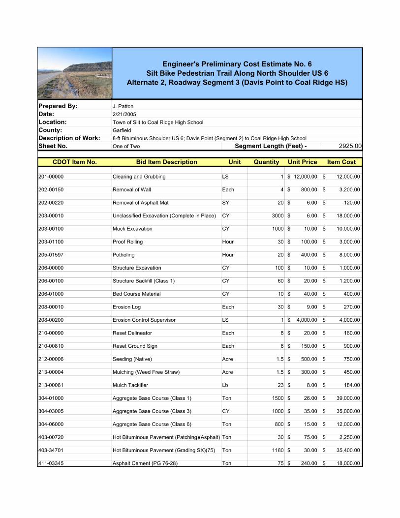
e. Engineering Cost Estimate. This alternate is at moderate construction cost. There may be some environmental impacts in wetlands areas requiring additional costs. Some right-of-way will be required with a cost unknown. Reference the separate cost estimates for segments 1, 2 and 3 for alternate two. The total construction cost for this alternate is 759,130 with Option 2 at Davis Point.
3. Alternate Three.
a. Description. Alternate Three places bike/pedestrian travel along both shoulders of US 6. The trail connects with the existing bike pedestrian trail on the west end near Mile Marker 100 on US 6 in Silt. On the east end, approximately 1.2 miles further the bike pedestrian trail ends at the new Coal Ridge High School. For eastbound travel along US 6, bicyclists must cross the highway at two locations, once on the west end and once on the east end. At Davis Point, Alternate Three has only Option 2 available. Alternate Three crosses County Road 235, Davis Point Road immediately beyond Davis Point for westbound travel only. After crossing CR 235, the Alternate Three alignment along both shoulders of US 6 through Segment 3.
b. Typical Section. Typical Sections for Alternate Three are shown on Typical Section Sheets 4 for Segments 1 and 3 and Typical Section Sheet 3 for Segment 2.
c. Layout Drawing. The layout drawing is shown on the aerial mapping sheet designated Alternate Three. The layout is along US 6 with widening for shoulders on each side through much of the extents. Where crossings of US 6 are required, the alignment needs to loop outward so that the crossing is at right angles to the roadway for adequate sight distance. Grades for the alignment are the same as those for US 6.
d. Advantages and Disadvantages. Table 2 provides a summary of advantages and disadvantages in comparison with the other alternates. This alternate provides the advantages that maintenance can be accomplished with normal roadway maintenance and bicyclist travel is uniform with vehicular travel direction. Disadvantages are that two crossings of US 6 are required for eastbound travel and this alternate is the least direct route. Wetlands mitigation may be required on both sides of the roadway.
e. Engineering Cost Estimate. This alternate is the most expensive construction cost. There may be some environmental impacts in wetlands

Feasibility Report A-CODOT0501.00 Colorado Department of Transportation Page 17
areas requiring additional costs. Some right-of-way will be required with a cost unknown. Reference the separate cost estimates for segments 1, 2 and 3 for Alternate Three. The total construction cost for this alternate is $1,213,416.
Summary of Alternates
Table 1 is a Summary of Alternate Construction Costs. Costs are separated into three segments along the project length. Segment 1 is west of Davis Point, Segment 2 is at Davis Point and Segment 3 is east of Davis Point as shown in Figure 2. Table 2 is a Summary of Advantages and Disadvantages of each Alternate. Conclusions and Recommended Alternate Alternate One is selected as the preferred alternate because it is the safest alternate due to separation of bike and pedestrian traffic from vehicular traffic throughout the majority of its length. As stated in the Project Scope – Introduction on Page 7, “The primary purpose of this trail is to provide safe pedestrian and bicycle non-motorized access from Silt to Coal Ridge High School.” This alternate best fulfills this goal. A primary disadvantage of Alternate One is that it has the most impact on wetlands areas. These areas are primarily in Segment 3. Alternate 1A crosses wetlands with a bituminous trail using additional stabilization that is free draining. Mitigation may be required for this alternate with the creation of new wetlands areas. Alternate 1B crosses wetlands at higher cost with an elevated bridged boardwalk trail. In reality, Alternate One should use a combination of these options with the cost somewhere in between the range of costs for Alternates 1A and 1B. Although Alternate Two is the least expensive alternate, it does not provide for separation of pedestrian, bike and vehicular traffic. Bike and pedestrian traffic on the north shoulder through Segments 2 and 3 will be dual directional while vehicular travel is west only on this side. This creates safety problems. Alternate Three also has safety problems in that bicyclists need to cross US 6 twice for eastbound travel from Silt to the high school. For both alternates pedestrian and bike travel is immediately adjacent to US 6 vehicular travel. Option 2 is preferred for Segment 2. This option is the least expensive and involves the least risk for stabilization and slide potential. Although it will involve some extension of the MSE wall, this extension will be less than that required for Option 1. Option 2 will require a shift of US 6 to the south to accommodate the trail. This shift however will improve sight distance for the intersection of CR 235 (Davis Point Road). The concrete raised sidewalk trail through this section is 6 feet in width with a four foot shoulder. This is a narrow section but is necessary due to the tight constraints presented at Davis Point.

Feasibility Report A-CODOT0501.00 Colorado Department of Transportation Page 18
Horizontal alignment for Alternate One should be placed as far from US 6 as is feasible throughout it length excepting Segment 2 at Davis Point. The alignment should have gentle curves within design criteria for its length rather than long straight tangents. Adequate sight distance is important at Davis Point.
Photo 6 – Coal Ridge High School under construction at east end of bike pedestrian trail
Feasibility Report A-CODOT0501.00 Colorado Department of Transportation Page 19
List of Typical Sections Sheet 1 Alternate One – Segments 1 and 3, Alternate Two – Segment 1; Alternate One - Wetlands Areas Sheet 2 Alternates One or Two – Option 1, Roadway Segment 2 (Davis Point) Sheet 3 Alternates One, Two or Three – Option 2, Roadway Segment 2 (Davis Point) Sheet 4 Alternate Two – Segment 3 Alternate Three – Segments 1 and 3
Feasibility Report A-CODOT0501.00 Colorado Department of Transportation Page 20
List of Layout Drawings Drawing 1 Alternate One – Project Location Bike Pedestrian Trail Drawing 2 Alternate Two – Project Location Bike Pedestrian Trail Drawing 3 Alternate Three – Project Location Bike Pedestrian Trail

Feasibility Report A-CODOT0501.00 Colorado Department of Transportation Page 21
List of Cost Estimates
Estimate 1 Alternates 1 or 2, Roadway Segment 1 (Silt to Davis Point) Estimate 2 Alternate 3, Roadway Segment 1 (Silt to Davis Point) Estimate 3 Alternates 1 or 2, Option 1, Roadway Segment 2 (Davis Point) Estimate 4 Alternates 1,2, or 3, Option 2, Roadway Segment 2 (Davis Point) Estimate 5 Alternate 1, Roadway Segment 3 (Davis Point to Coal Ridge High School) Estimate 6 Alternate 2, Roadway Segment 3 (Davis Point to Coal Ridge High School) Estimate 7 Alternate 3, Roadway Segment 3 (Davis Point to Coal Ridge High School) Wetlands Walkway Cost Estimate – Schmueser, Gordon and Meyer Engineers & Surveyors

Feasibility Report A-CODOT0501.00 Colorado Department of Transportation Page 22
List of Appendices
Appendix A 5-Year Analysis of US 6 Accident History Appendix B CDOT 2002 Accident and Rates Appendix C 2002 Average Daily Traffic Volume – County Road 235 (Davis Point Road) Appendix D Materials Recommendation Letter


01/14/2005Visual FoxPro Colorado Department of Transportation
Transportation Safety and Traffic EngineeringDetailed Accident Summary Report 20050114111429Job #:
Highway: 6D Begin: 99.38 End:101.70 From:01/01/1999 To:12/31/2003
PDO: 13INJ: 4
FAT: 0
Total: 17
One Vehicle: 8Two Vehicles: 8
Three or More: 1Unknown: 0
:Killed 0:Injured 5
On Road: 15
Off Road Right: 2
Off in Median: 0
At Intersection: 5
Other Non Collision: 1School Age Peds: 0
Broadside: 2Head On: 0Rear End: 2
Sideswipe (Same): 0Sideswipe (Opposite): 0
Approach Turn: 2Overtaking Turn: 2
Parked Motor Vehicle: 0Railway Vehicle: 0
Motorized Bicycle: 0
Wild Animal: 6Light/Utility Pole: 0
Total Other Objects: 0
Unknown: 0
Total: 17
Total: 17
Other Pedestrians: 1
Bicycle: 0
Domestic Animal: 0
Traffic Signal Pole: 0Sign: 0
Bridge Rail: 0Guard Rail: 0
Median Barrier: 0Bridge Abutment: 0
Column/Pier: 0Culvert/Headwall: 0
Embankment: 1Curb: 0
Total Fixed Objects: 1Delineator Post: 0Fence: 0
Tree: 0Large Boulder: 0
Rocks in Roadway: 0Barricade: 0
Wall/Building: 0Crash Cushion: 0
Mailbox: 0Other Fixed Object: 0
Involving Other Object: 0Road Maintenance Equipment: 0
Off Road Left: 0
Off Road at Tee: 0
Unknown: 0
Total: 17
At Driveway Access: 4Intersection Related: 0
Non Intersection Urban: 1In Alley: 0
Non Intersection Rural: 7Highway Interchange: 0
Unknown: 0
Total: 17
Overturning: 0
Daylight: 11Dawn or Dusk: 0Dark - Lighted: 0
Dark - Unlighted: 6Unknown: 0
Total: 17
None: 16Rain: 0
Snow/Sleet/Hail: 1Fog: 0
Unknown: 0
Total: 17
Dust: 0Wind: 0
Dry: 15Wet: 1
Muddy: 0Snowy: 1
Unknown: 0
Total: 17
Icy: 0Slushy: 0
Foreign Material: 0
Dry w/Icy Road Treatment: 0Wet w/Icy Road Treatment: 0
Snowy w/Icy Road Treatment: 0Icy w/Icy Road Treatment: 0
Slushy w/Icy Road Treatment: 0
Mainline: 17Crossroad (Ramp A): 0
B: 0C: 0D: 0E: 0F: 0
Uknwn: 0 Total: 17
G: 0
H: 0I: 0
J: 0K: 0T: 0
Road Description
Lighting Conditions
Mainline/Ramps/Frontage Rds
Weather Conditions
Road Conditions
Accident Type
Severity Multi-Vehicle Location
With Road Treatment: 0
Injury: 0.28Fatal: 0.00
Total: 1.19
Accident Rates
PDO: 0.91 MVMTMVMT100 MVMT
MVMT
M: 0 N: 0
Ramps
Intsx Frontage/Ramps
O: 0 P: 0
HOV Lanes: 0
Frontage Rd: 0
Page 1Any intentional or inadvertant release of this data or any data derived fromits use shall not constitute a waiver of privilege pursuant to 23 USC 409.
ADT: 3380 Length: 2.31WHI: -3.26 Coris File: tcoris2004.dbf
01/14/2005Visual FoxPro Colorado Department of Transportation
Transportation Safety and Traffic EngineeringDetailed Accident Summary Report 20050114111429Job #:
Highway: 6D Begin: 99.38 End:101.70 From:01/01/1999 To:12/31/2003
North: 0Northeast: 0
East: 6Southeast: 0
South: 2Southwest: 0
West: 9
Unknown: 0
Total: 17
Northwest: 0
Passenger Car/Van: 10Passenger Car/Van w/Trl: 0
Pickup Truck/Utility Van: 7Pickup Truck/Utility Van w/Trl: 0
Unknown: 0
Total: 17
Truck 10k lbs or Less: 0Trucks > 10k lbs/Bus > 15 People: 0
Motorhome: 0
School Bus < 15 People: 0Non School Bus < 15 People: 0
Motorcycle: 0
Motorized Bicycle: 0Farm Equipment: 0
Hit and Run - Unknown: 0Other: 0
Bicycle: 0
Vehicle Type Veh 1 Veh 2 Veh 3
5 0 3 0
0
9
0 0
0
0 0
0
0 1 0 0
0
1 0 0 0
0
1
0 0
0
0 0
0
0 0 0 0
0
Direction
0 0 4 0 0 0 5
0
9
0
1 0 0 0 0 0 0
0
1
0
No Apparent Contributing Factor: 13Asleep at the Wheel: 0
Illness: 0Distracted by Passenger: 0
Unknown: 0
Total: 17
Driver Inexperience: 1Driver Fatigue: 0
Driver Emotionally Upset: 0
Driver Preoccupied: 2Driver Unfamilar with Area: 0
Evading Law Enforcement Officier: 0Physical Disability: 1
Contributing Factor
8 0 0 0
0
9
0 0
0
1 0
00
1 0 0 0
0
1
0 0
0
0 0
00
No Impairment Suspected: 13Alcohol Involved: 0
RX Drugs or Medication Involved: 0Illegal Drugs Involved: 0
Alcohol and Drugs Involved: 0Driver/Pedestrian not Observed: 2
Unknown: 2
Total: 17
Condition of Driver
7 0 0 0 0 0 2
9
0 0 0 0 0 0 1
1
Veh 1 Veh 2 Veh 3
Veh 1 Veh 2 Veh 3 Veh 1 Veh 2 Veh 3
Going Straight: 12Slowing: 0
Stopped in Traffic: 0Making Right Turn: 0
Unknown: 0
Total: 17
Making Left Turn: 3Making U-Turn: 0
Enter/Leave Parked Position: 0
Passing: 2Backing: 0
Starting in Traffic: 0
Changing Lanes: 0Avoiding Object in Road: 0
Weaving: 0Other: 0
Parked: 0
Vehicle Movement Veh 1 Veh 2 Veh 3
4 1 0 1
0
9
3 0
0
0 0
0
0 0 0 0
0
0 0 0 0
0
1
0 0
0
0 0
0
0 0 0 1
0
Page 2Any intentional or inadvertant release of this data or any data derived fromits use shall not constitute a waiver of privilege pursuant to 23 USC 409.
ADT: 3380 Length: 2.31WHI: -3.26 Coris File: tcoris2004.dbf
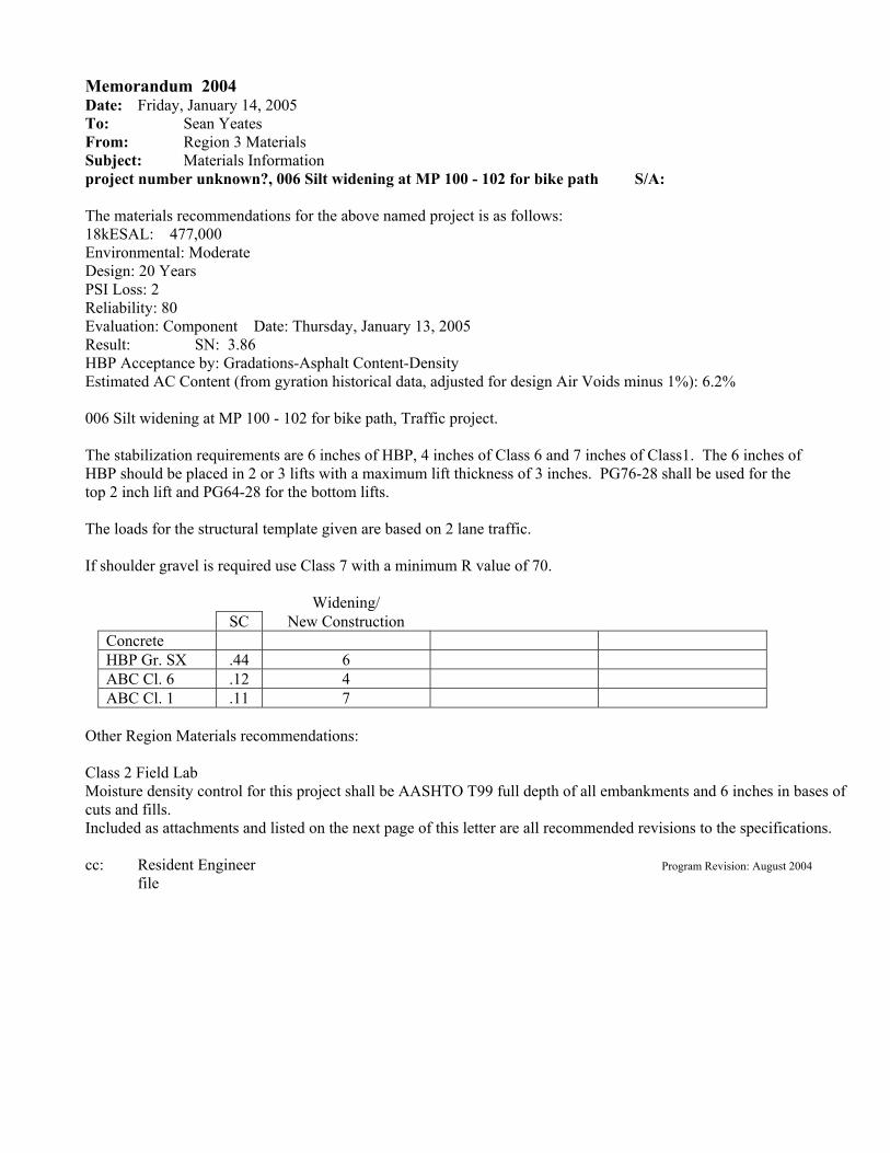
Memorandum 2004 Date: Friday, January 14, 2005 To: Sean Yeates From: Region 3 Materials Subject: Materials Information project number unknown?, 006 Silt widening at MP 100 - 102 for bike path S/A: The materials recommendations for the above named project is as follows: 18kESAL: 477,000 Environmental: Moderate Design: 20 Years PSI Loss: 2 Reliability: 80 Evaluation: Component Date: Thursday, January 13, 2005 Result: SN: 3.86 HBP Acceptance by: Gradations-Asphalt Content-Density Estimated AC Content (from gyration historical data, adjusted for design Air Voids minus 1%): 6.2% 006 Silt widening at MP 100 - 102 for bike path, Traffic project. The stabilization requirements are 6 inches of HBP, 4 inches of Class 6 and 7 inches of Class1. The 6 inches of HBP should be placed in 2 or 3 lifts with a maximum lift thickness of 3 inches. PG76-28 shall be used for the top 2 inch lift and PG64-28 for the bottom lifts. The loads for the structural template given are based on 2 lane traffic. If shoulder gravel is required use Class 7 with a minimum R value of 70.
Widening/ SC New Construction Concrete HBP Gr. SX .44 6 ABC Cl. 6 .12 4 ABC Cl. 1 .11 7
Other Region Materials recommendations: Class 2 Field Lab Moisture density control for this project shall be AASHTO T99 full depth of all embankments and 6 inches in bases of cuts and fills. Included as attachments and listed on the next page of this letter are all recommended revisions to the specifications. cc: Resident Engineer Program Revision: August 2004 file

Notice
The following revisions should be included in the plans for project number unknown?, 006 Silt widening at MP 100 - 102 for bike path. If the revisions marked with a “#” are necessary, they should be modified as noted and included. #Revision of Section 304 AGGREGATE BASE COURSE Base Course: Class 6, R-value 78 Subbase: Class 1, R-value 70 ______________________________________________________________________________ The following Materials Related Special Provisions or Project Special Provisions should be included in this project. This list may not be complete. Please check the Standard Project Special Provisions Index. Revision of Section 105 – Conformity with Plans and Specifications Revision of Section 203 - Proof Rolling Revision of Section 105, 106 and 203 Quality of Embankment Revision of Sections 105 and 106 - Quality of Hot Bituminous Pavement Revision of Section 702 - Superpave PG Binders Revision of Section 401 - Plant Mix Pavements Revision of Section 401 - Plant Mix Pavements – General Revision of Section 401 – Bituminous Pavers Revision of Section 401 – Weather Limitations and Placement Temperatures Revision of Sections 105, 202, 401, 405, 406, 412 – Roadway Smoothness Revision of Sections 106 and 620 – Qualifications of Testing Personnel and Laboratories Revision of Section 620 – Field Laboratories with Forced Air Convection Oven

REVISION OF SECTION 403
HOT BITUMINOUS PAVEMENT (GRADING SX) (75) Section 403 of the Standard Specifications is hereby revised for this project as follows: Subsection 403.02 shall include the following: The design mix for hot bituminous pavement shall conform to the following:
TABLE 403-1 VALUE FOR PROPERTY TEST METHOD GRADING SX (75) Air Voids, percent at N(des) CPL 5115 3.5-4.5 Lab Compaction (Revolutions) N(des) CPL 5115 75 Stability, minimum CPL 5106 28 Aggregate retained on the No. 4 sieve with at least 2 Mechanically Induced fractured faces, % minimum CP 45 70 Accelerated Moisture Susceptibility Tensile Strength Ratio (Lottman), minimum CPL 5109 80 Method B Minimum Dry Split Tensile Strength, psi (kPa) CPL 5109 30 (205) Method B Grade of Asphalt Cement, Top Layer PG 76-28 Grade of Asphalt Cement, Layers Below Top PG 64-28 Voids in the Mineral Aggregate (VMA), % min CP 48 See TABLE 403-2 Voids Filled with Asphalt (VFA), % AI MS-2 65-80 Dust to Asphalt Ratio Fine Gradation CP-50 0.6 — 1.2 Coarse Gradation CP-50 0.8 — 1.6 ___________________________________________________________________________ Note: AI MS-2 = Asphalt Institute Manual Series 2 Note: The current version of CPL 5115 is available from the Region Materials Engineer Note: Mixes with gradations having less than 40% passing the No. 4 sieve shall be approached with caution
because of constructability problems. Note: Gradations for mixes with a nominal maximum aggregate size of one-inch or larger are considered a
coarse gradation if they pass below the maximum density line at the #4 screen. Gradations for mixes with a nominal maximum aggregate size of ¾ inch or smaller are considered a coarse gradation if they pass below the maximum density line at the #8 screen.
All mix designs shall be run with a gyratory compaction angle of 1.25 degrees and properties must satisfy Table 403-1. CDOT Form #43 will establish construction targets for Asphalt Cement and all mix properties at Air Voids up to 1.0% below the mix design optimum.

REVISION OF SECTION 403
HOT BITUMINOUS PAVEMENT (GRADING SX) (75)
-2-
TABLE 403-2 Minimum Voids in the Mineral Aggregate (VMA)
***Design Air Voids ** Nominal Maximum Size *
Inches (mm) 3.5% 4.0% 4.5%
1 1/2 (37.5) 11.6 11.7 11.8
1 (25.0) 12.6 12.7 12.8
3/4 (19.0) 13.6 13.7 13.8
1/2 (12.5) 14.6 14.7 14.8
3/8 (9.5) 15.6 15.7 15.8
* The nominal size is defined as one sieve larger than the first sieve to retain more than 10% ** Interpolate specified VMA values for design air voids between those listed. *** Extrapolate specified VMA values for production air voids beyond those listed.
The Contractor shall prepare a quality control plan outlining the steps taken to minimize segregation of HBP. This plan shall be submitted to the Engineer and approved prior to beginning the paving operations. When the Engineer determines that segregation is unacceptable, the paving shall stop and the cause of segregation shall be corrected before paving operations will be allowed to resume. A minimum of one percent hydrated lime by mass (weight) of the combined aggregate shall be added to the aggregate for all hot bituminous pavement. Acceptance samples shall be taken at the location specified in either Method B or C of CP 41, as determined by the Region Construction and Materials personnel. The hot bituminous pavement shall not contain any reclaimed asphalt pavement. Hot bituminous pavement for patching shall conform to the requirements for Hot Bituminous Pavement (GRADING SX) (75). In Subsection 403.05 delete the third paragraph and replace with the following: Aggregate, asphalt recycling agent, additives, hydrated lime, and all other work necessary to complete each hot bituminous pavement item will not be paid for separately but shall be included in the unit price bid. Asphalt cement will be measured and paid for in accordance with Section 411 except that asphalt cement used in Hot Bituminous Pavement (Patching) will not be measured and paid for separately, but shall be included in the work.

From: Roussin, Daniel Sent: Monday, February 14, 2005 3:20 PM To: Nall, Jim; Hudson, Skip Cc: Egghart, Hans Subject: FW: These are 2002 24 hour counts for Davis Point Road. This is will be our baseline number if there is a development to the North. I will keep everyone informed. Thanks ] Dan Roussin From: Jeff Nelson [mailto:[email protected]] Sent: Monday, February 14, 2005 1:12 PM To: Roussin, Daniel Subject: Cr 235 Davis Point= 307 ADT
Jeff T Nelson
Assistant County Engineer
Garfield County Engineering Dept.
144 E Third St.
Rifle, Co. 81650
tel: 970-625-6172
fax: 970-625-0908 The information contained in this electronic mail transmission is the property of the Garfield County Engineering Dept. It is intended only for the use of the individual or entity named above and is privileged and confidential. Any other use, dissemination, distribution or copying of this communication is strictly prohibited. If you have received this communication in error please notify the sender immediately, delete it from your system and destroy any printouts and/or copies.

Segment Alternate
Estim
ate
No. Alternate Description Construction Cost
from Estimates**
Estimated Additional ROW Needed (Acres)
One or Two 1 10-ft Bituminous Bike Pedestrian Trail Separated from US 6 Including Three Ditch Crossings 262,960.80$ 1.80
Three 2 8-ft Bituminous Shoulders on US 6 for directional biking 537,629.60$ 0.70
One or Two, Option 1 3 8-ft Bituminous Bike Pedestrian Trail Separated from US 6 Located on Upper Bench 186,440.40$ 0.40
One or Two, Option 2 4 6-ft Concrete Bike Pedestrian Trail Adjacent to US 6 Along North Shoulder 164,402.28$ 0.00
Three, Option 2 4 8-ft Bituminous Shoulders on US 6 for directional biking 164,402.28$ 0.00
One - A 5A 10-ft Bituminous Bike Pedestrian Trail Separated from US 6 Including Two Ditch Crossings 353,040.00$ 3.60
One - B 5B 10-ft Boardwalk Bike Pedestrian Trail Separated from US 6 Including Two Ditch Crossings 939,615.60$ 1.80
Two 6 10-ft Bituminous North Shoulder on US 6 331,776.73$ 1.60
Three 7 8-ft Bituminous Shoulders on US 6 for directional biking 511,384.30$ 2.60
** Includes 15% (or 20% depending on alternate) for Construction Engineering and Contingencies (See Report for Explanation)
Table 1 - Summary of Alternate Construction Costs
Segm
ent 1
Silt
to D
avis
Po
int,
Wes
t En
d
Segm
ent 2
at D
avis
Poi
nt
Segm
ent 3
Dav
is P
oint
to C
oal
Rid
ge H
igh
Scho
ol

Alternate Safety Features Advantages Disadvantages Construction Cost from Estimates** Comments
Good sight distances possible with exception of Davis Point 1 Reduced conflicts with motorists Construction in sensitive areas 780,403$
Separation from US 6 with reduced conflict points Better aesthetics possible Most impact to wetlands areas
Safest alternate due to separation Steepest grades for short distances near Davis Point
Next to least expensive alternate Does not provide separation of pedestrian and bike traffic
Gates may be required at some locations along route for locations outside of US 6 right-of-way
Good sight distances possible with exception of Davis Point 1 Reduced conflicts with motorists Construction in sensitive areas 1,366,979$
Separation from US 6 with reduced conflict points Better aesthetics possible Steepest grades for short distances near Davis
Point
Safest alternate due to separation Does not provide separation of pedestrian and bike traffic
Gates may be required at some locations along route for locations outside of US 6 right-of-wayMost expensive alternate due to boardwalks in
wetland areas for Segment 3
Grades comparable to US 6 Maintenance can be included with normal roadway maintenance 2
Bike travel is inconsistent with motorist travel direction east direction 759,130$
Provide 8-Inch edge strip on north side Provides moderate expensive alternate Travel may be blocked occasionally with parked
cars 3
Good sight distances Requires the least additional right-of-way and least wetlands impact
Does not provide separation of pedestrian, bike and vehicular traffic
Least expensive alternate Signage is difficult due to dual direction of pedestrians and bicyclists along north shoulder.
Grades comparable to US 6 Bike travel is consistent with motorist travel direction Requires two crossings of US 6 for travel east 1,213,500$
Provide 8-Inch edge strip on north side
Maintenance can be included with normal roadway maintenance 2 Travel may be blocked with parked cars 3
Bike travel directional with motorist Least direct route of the other alternates
Provide 90 Crossings of US 6 User may cross over US 6 at unexpected times
Good sight distances
** Includes 15% (or 20% depending on alternate) for Engineering and Contingencies; all estimated alternate costs include Option 2 for Segment 2 for like comparison
Table 2 - Evaluation of AlternatesA
ltern
ate
1A -
Bitu
min
ous
Trai
l for
Se
gmen
t 3; S
epar
atio
n fr
om U
S 6
Alte
rnat
e 2
- Adj
oini
ng U
S 6,
N
orth
Sho
ulde
rA
ltern
ate
3 - A
djoi
ning
US
6,
Shou
lder
Wid
enin
g B
oth
Side
s
1 Improvement of sight distance can be made at Davis Point by closure or realignment of County Road No. 235 (Davis Point Road) 2 Although mainenance is included with normal roadway maintenance, it places additional burden on CDOT forces 3 Provide "No Parking" Signs near High School
Alte
rnat
e 1B
- B
oard
wal
k Tr
ail
for S
egm
ent 3
; Sep
arat
ion
from
U
S 6

glenwood springs
118 w. 6th, suite 200
glenwood springs, co 81601
970-945-1004
fx: 970-945-5948
aspen
p.o. box 2155
aspen, co 81612
970-925-6727
fx: 970-925-4157
crested butte
p.o. box 3088
crested butte, co 81224
970-349-5355
fx: 970-349-5358
April 14, 2005 Ms. Janet Steinbach, Community Development Director Town of Silt 231 No. 7th Street P.O. Box 70 Silt CO 81652 RE: Wetlands Walkway Cost Estimate SGM Project No. 2002-151.001 Phase 12 Dear Janet: Per your request, we have prepared an estimate for a boardwalk, 10 ft. wide and approximately 3000 ft in length, to cross wetlands west of the new Coal Ridge High School. It is based on the following system:
º Helical piers placed at 10 ft on center, average depth 15 ft. º Treated wood beams and joists º Trex-deck type composite weatherproof decking º Timber railing
We have used this system previously on a project in wetlands near Wolcott. We understand that the boardwalk will be within the highway right of way, so it will be near or adjacent to the highway. We have therefore assumed the pier installation equipment will be able to operate on the shoulder. Where no shoulder exists, traffic control will be needed during pier and boardwalk installation. Our estimate is based on pricing from local materials suppliers, and published data for labor production rates. Accuracy of the foundation (pier) design will depend upon actual geotechnical investigations, which should be completed for final design. Based on this, we estimate a total cost of $1,017,690. Please see the attached spreadsheet for a breakdown of values. Costs include engineering and construction. We trust this is adequate for your needs at the present time. Should you have any questions, please call me at 945-1004. Sincerely, SCHMUESER GORDON MEYER, INC. William B. Swigert, PE SE File I:2002-151/001-Engineering/12-Coal Ridge Trail
I:\2002\2002-151\001 - Engineering\12 - Coal Ridge Trail\April 14.doc

14-Apr-05Coal Ridge Trail Boardwalk, 2925 ft lengthTown of SiltSGM Job No. 2002-151.001-12
UOM QUANTITY UNIT PRICE TOTALhelical piers, 15 ft length, installed ea 600 475.00$ 285,000.00$
pier cap assembly ea 600 30.00$ 18,000.00$
4x14 beam, 10 ft length, treated ea 294 60.67$ 17,836.98$
2x10 joists, 10 ft length, treated ea 2048 14.13$ 28,938.24$
5/4 x 6 TREX decking, 20 ft length ea 2925 36.80$ 107,640.00$
heavy timber railing & posts, 42" high lf 6000 3.71$ 22,260.00$
epoxy coated wire mesh guard sf 24000 2.45$ 58,800.00$
labor - framing sf 30000 3.39$ 101,700.00$
2 ton crane hr 240 120.00$ 28,800.00$
construction surveying ls 10,000.00$ 10,000.00$
mobilization ls 20,000.00$ 20,000.00$
construction traffic control hr 300 50.00$ 15,000.00$
profit & overhead ls 134,100.00$ 134,100.00$
subtotal 848,075.22$ 20% for engineering & contingencies 169,615.04$
total 1,017,690$
Note: This estimate is an opinion of probable cost based on information furnished by the client and the bestavailable data known to the engineer at the time. It is for budgetary purposes only and is not a guarantee of overall project costs.
const estimate.xls4/18/2005 Page1 of 1
William B. Swigert, PE SESchmueser Gordon Meyer, Inc
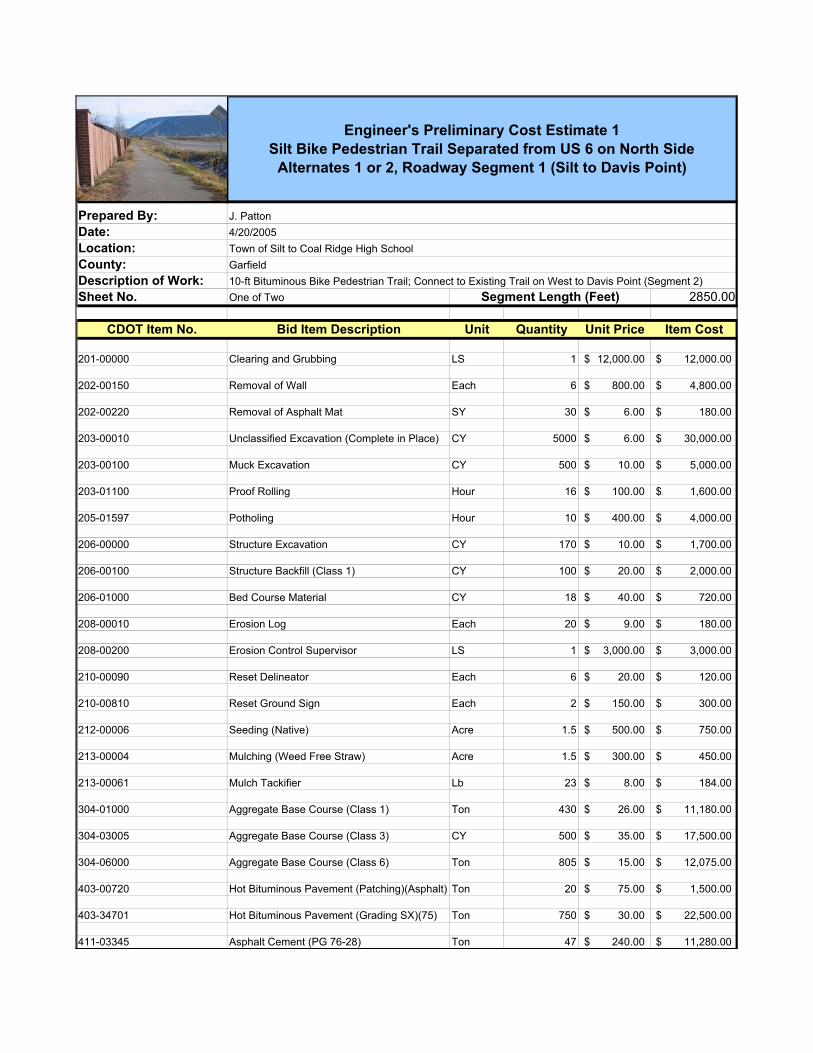
Prepared By:Date: Location: County:Description of Work: Sheet No. One of Two 2850.00
CDOT Item No. Bid Item Description Unit Quantity Unit Price Item Cost
201-00000 Clearing and Grubbing LS 1 12,000.00$ 12,000.00$
202-00150 Removal of Wall Each 6 800.00$ 4,800.00$
202-00220 Removal of Asphalt Mat SY 30 6.00$ 180.00$
203-00010 Unclassified Excavation (Complete in Place) CY 5000 6.00$ 30,000.00$
203-00100 Muck Excavation CY 500 10.00$ 5,000.00$
203-01100 Proof Rolling Hour 16 100.00$ 1,600.00$
205-01597 Potholing Hour 10 400.00$ 4,000.00$
206-00000 Structure Excavation CY 170 10.00$ 1,700.00$
206-00100 Structure Backfill (Class 1) CY 100 20.00$ 2,000.00$
206-01000 Bed Course Material CY 18 40.00$ 720.00$
208-00010 Erosion Log Each 20 9.00$ 180.00$
208-00200 Erosion Control Supervisor LS 1 3,000.00$ 3,000.00$
210-00090 Reset Delineator Each 6 20.00$ 120.00$
210-00810 Reset Ground Sign Each 2 150.00$ 300.00$
212-00006 Seeding (Native) Acre 1.5 500.00$ 750.00$
213-00004 Mulching (Weed Free Straw) Acre 1.5 300.00$ 450.00$
213-00061 Mulch Tackifier Lb 23 8.00$ 184.00$
304-01000 Aggregate Base Course (Class 1) Ton 430 26.00$ 11,180.00$
304-03005 Aggregate Base Course (Class 3) CY 500 35.00$ 17,500.00$
304-06000 Aggregate Base Course (Class 6) Ton 805 15.00$ 12,075.00$
403-00720 Hot Bituminous Pavement (Patching)(Asphalt) Ton 20 75.00$ 1,500.00$
403-34701 Hot Bituminous Pavement (Grading SX)(75) Ton 750 30.00$ 22,500.00$
411-03345 Asphalt Cement (PG 76-28) Ton 47 240.00$ 11,280.00$
Engineer's Preliminary Cost Estimate 1 Silt Bike Pedestrian Trail Separated from US 6 on North Side
Alternates 1 or 2, Roadway Segment 1 (Silt to Davis Point)
10-ft Bituminous Bike Pedestrian Trail; Connect to Existing Trail on West to Davis Point (Segment 2)
J. Patton4/20/2005Town of Silt to Coal Ridge High SchoolGarfield
Segment Length (Feet)
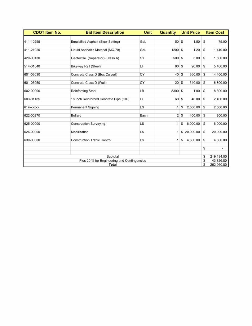
CDOT Item No. Bid Item Description Unit Quantity Unit Price Item Cost
411-10255 Emulsified Asphalt (Slow Setting) Gal. 50 1.50$ 75.00$
411-21020 Liquid Asphaltic Material (MC-70) Gal. 1200 1.20$ 1,440.00$
420-00130 Geotextile (Separator) (Class A) SY 500 3.00$ 1,500.00$
514-01040 Bikeway Rail (Steel) LF 60 90.00$ 5,400.00$
601-03030 Concrete Class D (Box Culvert) CY 40 360.00$ 14,400.00$
601-03050 Concrete Class D (Wall) CY 20 340.00$ 6,800.00$
602-00000 Reinforcing Steel LB 8300 1.00$ 8,300.00$
603-01185 18 Inch Reinforced Concrete Pipe (CIP) LF 60 40.00$ 2,400.00$
614-xxxxx Permanent Signing LS 1 2,500.00$ 2,500.00$
622-00270 Bollard Each 2 400.00$ 800.00$
625-00000 Construction Surveying LS 1 8,000.00$ 8,000.00$
626-00000 Mobilization LS 1 20,000.00$ 20,000.00$
630-00000 Construction Traffic Control LS 1 4,500.00$ 4,500.00$
-$
219,134.00$ 43,826.80$
262,960.80$
SubtotalPlus 20 % for Engineering and Contingencies
Total

Prepared By:Date: Location: County:
Description of Work: Sheet No. One of Two 2850.00
CDOT Item No. Bid Item Description Unit Quantity Unit Price Item Cost
201-00000 Clearing and Grubbing LS 1 9,000.00$ 9,000.00$
202-00150 Removal of Wall Each 12 800.00$ 9,600.00$
202-00220 Removal of Asphalt Mat SY 30 6.00$ 180.00$
203-00010 Unclassified Excavation (Complete in Place) CY 4500 6.00$ 27,000.00$
203-00100 Muck Excavation CY 500 10.00$ 5,000.00$
203-01100 Proof Rolling Hour 16 100.00$ 1,600.00$
205-01597 Potholing Hour 20 400.00$ 8,000.00$
206-00000 Structure Excavation CY 180 10.00$ 1,800.00$
206-00100 Structure Backfill (Class 1) CY 90 20.00$ 1,800.00$
206-01000 Bed Course Material CY 20 40.00$ 800.00$
208-00010 Erosion Log Each 30 9.00$ 270.00$
208-00200 Erosion Control Supervisor LS 1 3,000.00$ 3,000.00$
210-00090 Reset Delineator Each 12 20.00$ 240.00$
210-00810 Reset Ground Sign Each 5 150.00$ 750.00$
212-00006 Seeding (Native) Acre 1.5 500.00$ 750.00$
213-00004 Mulching (Weed Free Straw) Acre 1.5 300.00$ 450.00$
213-00061 Mulch Tackifier Lb 23 8.00$ 184.00$
304-01000 Aggregate Base Course (Class 1) Ton 2900 26.00$ 75,400.00$
304-03005 Aggregate Base Course (Class 3) CY 500 35.00$ 17,500.00$
304-06000 Aggregate Base Course (Class 6) Ton 1640 15.00$ 24,600.00$
403-00720 Hot Bituminous Pavement (Patching)(Asphalt) Ton 20 75.00$ 1,500.00$
403-34701 Hot Bituminous Pavement (Grading SX)(75) Ton 2300 30.00$ 69,000.00$
Segment Length (Feet) -
Engineer's Preliminary Cost Estimate No. 2 Silt Bike Pedestrian Trail Along Both Sides of US 6
Alternate 3, Roadway Segment 1 (Silt to Davis Point)
8-ft Bituminous Shoulders US 6 for directional biking; Connect to Existing Trail West End to Davis Point (Segment 2)
J. Patton2/17/2005Town of Silt to Coal Ridge High SchoolGarfield

CDOT Item No. Bid Item Description Unit Quantity Unit Price Item Cost411-03345 Asphalt Cement (PG 76-28) Ton 150 240.00$ 36,000.00$
411-10255 Emulsified Asphalt (Slow Setting) Gal. 320 1.50$ 480.00$
411-21020 Liquid Asphaltic Material (MC-70) Gal. 2000 1.20$ 2,400.00$
420-00130 Geotextile (Separator) (Class A) SY 500 3.00$ 1,500.00$
514-01040 Bikeway Rail (Steel) LF 120 90.00$ 10,800.00$
601-03030 Concrete Class D (Box Culvert) CY 150 360.00$ 54,000.00$
601-03050 Concrete Class D (Wall) CY 80 340.00$ 27,200.00$
602-00000 Reinforcing Steel LB 30500 1.00$ 30,500.00$
603-01185 18 Inch Reinforced Concrete Pipe (CIP) LF 60 40.00$ 2,400.00$
614-xxxxx Permanent Signing LS 1 3,000.00$ 3,000.00$
622-00270 Bollard Each 2 400.00$ 800.00$
625-00000 Construction Surveying LS 1 10,000.00$ 10,000.00$
626-00000 Mobilization LS 1 25,000.00$ 25,000.00$
630-00000 Construction Traffic Control LS 1 5,000.00$ 5,000.00$
-$
467,504.00$ 70,125.60$
537,629.60$
SubtotalPlus 15 % for Engineering and Contingencies
Total
Prepared By:Date: Location: County:Description of Work: Sheet No. One of One 625.00
CDOT Item No. Bid Item Description Unit Quantity Unit Price Item Cost
203-00060 Embankment Material (Complete in Place) CY 1070 8.00$ 8,560.00$
203-00595 Rock Scaling SY 100 15.00$ 1,500.00$
203-01550 Dozing Hour 20 125.00$ 2,500.00$
206-00000 Structure Excavation CY 300 10.00$ 3,000.00$
206-00100 Structural Backfill (Class 1) CY 240 20.00$ 4,800.00$
206-00360 Mechanical Reinforcement of Soil CY 750 15.00$ 11,250.00$
210-00040 Reset Water Line LS 1 6,500.00$ 6,500.00$
304-06000 Aggregate Base Course (Class 6) Ton 185 15.00$ 2,775.00$
403-34701 Hot Bituminous Pavement (75) Ton 129 24.00$ 3,096.00$
411-03352 Asphalt Cement (PG 58-28) Ton 8 200.00$ 1,600.00$
411-21020 Liquid Asphaltic Material (MC-70) Gal. 255 1.20$ 306.00$
504-04410 Block Facing SF 4500 15.00$ 67,500.00$
601-03020 Concrete Class D (Miscellaneous) CY 10 320.00$ 3,200.00$
602-00000 Reinforcing Steel Lb. 300 0.60$ 180.00$
607-53160 Fence Chain Link (60 Inch) Lin. Ft. 500 30.00$ 15,000.00$
608-10010 Sidewalk Drain Each 4 900.00$ 3,600.00$
626-00000 Mobilization LS 1 20,000.00$ 20,000.00$
155,367.00$ 31,073.40$
186,440.40$
Segment Length (Feet) -
SubtotalPlus 20 % for Engineering and Contingencies
Total
Engineer's Preliminary Cost Estimate No. 3 Bike Pedestrian Trail Separated From US 6 Located on Upper Bench -
Alternate 1 or 2, Option 1 Roadway Segment 2 (Davis Point)
8-ft Bituminous Bike Pedestrian Trail; Additional MSE Wall and Block Facing Required
J. Patton4/20/2005Town of Silt to Coal Ridge High SchoolGarfield

Prepared By:Date: Location: County:Description of Work: Sheet No. One of One 625.00
CDOT Item No. Bid Item Description Unit Quantity Unit Price Item Cost
202-00220 Removal of Asphalt Mat SY 550 6.00$ 3,300.00$
202-00810 Removal of Ground Sign Each 2 100.00$ 200.00$
202-01140 Removal of Guard Rail Type 4 LF 500 20.00$ 10,000.00$
203-00010 Unclassified Excavation (Complete in Place) CY 760 6.00$ 4,560.00$
205-01597 Potholing Hour 4 400.00$ 1,600.00$
206-00000 Structure Excavation CY 100 10.00$ 1,000.00$
206-00100 Structure Backfill (Class 1) CY 80 20.00$ 1,600.00$
206-00360 Mechanical Reinforcement of Soil CY 200 15.00$ 3,000.00$
304-01000 Aggregate Base Course (Class 1) Ton 415 26.00$ 10,790.00$
304-06000 Aggregate Base Course (Class 6) Ton 300 15.00$ 4,500.00$
403-00720 Hot Bituminous Pavement (Patching)(Asphalt) Ton 20 75.00$ 1,500.00$
403-34701 Hot Bituminous Pavement (Grading SX)(75) Ton 540 30.00$ 16,200.00$
411-03345 Asphalt Cement (PG 76-28) Ton 35 240.00$ 8,400.00$
411-10255 Emulsified Asphalt (Slow Setting) Gal. 155 1.50$ 232.50$
411-21020 Liquid Asphaltic Material (MC-70) Gal. 230 1.20$ 276.00$
504-04410 Block Facing SF 500 15.00$ 7,500.00$
603-50018 18 Inch Plastic Pipe LF 300 40.00$ 12,000.00$
604-19005 Inlet Type R L 5 (5 Foot) Each 2 1,500.00$ 3,000.00$
608-00000 Concrete Sidewalk SY 400 30.00$ 12,000.00$
608-00010 Concrete Curb Ramp SY 10 60.00$ 600.00$
608-10010 Sidewalk Drain Each 4 900.00$ 3,600.00$
609-21020 Curb and Gutter Type 2 (Section II-B) LF 600 14.00$ 8,400.00$
614-xxxxx Permanent Signing LS 1 1,500.00$ 1,500.00$
Segment Length (Feet) -
Engineer's Preliminary Cost Estimate No. 4 Silt Bike Pedestrian Trail Adjacent to US 6
Alternates 1, 2 or 3, Option 2, Roadway Segment 2 (Davis Point)
6-foot Concrete Bike Pedestrian Trail; Additional MSE Wall and Block Facing Required
J. Patton2/21/2005Town of Silt to Coal Ridge High SchoolGarfield
CDOT Item No. Bid Item Description Unit Quantity Unit Price Item Cost
625-00000 Construction Surveying LS 1 6,000.00$ 6,000.00$
626-00000 Mobilization LS 1 20,000.00$ 20,000.00$
627-00002 Thermoplastic Pavement Marking SF 100 2.00$ 200.00$
627-00005 Epoxy Pavement Marking Gal. 20 50.00$ 1,000.00$
142,958.50$ 21,443.78$
164,402.28$
SubtotalPlus 15 % for Engineering and Contingencies
Total

Prepared By:Date: Location: County:Description of Work: Sheet No. One of Two 2925.00
CDOT Item No. Bid Item Description Unit Quantity Unit Price Item Cost
201-00000 Clearing and Grubbing LS 1 13,000.00$ 13,000.00$
202-00150 Removal of Wall Each 4 800.00$ 3,200.00$
202-00220 Removal of Asphalt Mat SY 10 6.00$ 60.00$
203-00061 Embankment Material (Complete in Place) CY 6500 6.00$ 39,000.00$
203-00100 Muck Excavation CY 1850 10.00$ 18,500.00$
203-01100 Proof Rolling Hour 30 100.00$ 3,000.00$
205-01597 Potholing Hour 10 400.00$ 4,000.00$
206-00000 Structure Excavation CY 120 10.00$ 1,200.00$
206-00100 Structure Backfill (Class 1) CY 70 20.00$ 1,400.00$
206-01000 Bed Course Material CY 10 40.00$ 400.00$
208-00010 Erosion Log Each 30 9.00$ 270.00$
208-00200 Erosion Control Supervisor LS 1 3,000.00$ 3,000.00$
210-00090 Reset Delineator Each 6 20.00$ 120.00$
210-00810 Reset Ground Sign Each 4 150.00$ 600.00$
212-00006 Seeding (Native) Acre 2 500.00$ 1,000.00$
213-00004 Mulching (Weed Free Straw) Acre 2 300.00$ 600.00$
213-00061 Mulch Tackifier Lb 30 8.00$ 240.00$
304-03005 Aggregate Base Course (Class 3) CY 1850 35.00$ 64,750.00$
304-06000 Aggregate Base Course (Class 6) Ton 820 15.00$ 12,300.00$
403-34701 Hot Bituminous Pavement (Grading SX)(75) Ton 590 30.00$ 17,700.00$
411-03345 Asphalt Cement (PG 76-28) Ton 37 240.00$ 8,880.00$
411-21020 Liquid Asphaltic Material (MC-70) Gal. 1150 1.20$ 1,380.00$
420-00130 Geotextile (Separator) (Class A) SY 7600 3.00$ 22,800.00$
Segment Length (Feet) -
Engineer's Preliminary Cost Estimate No. 5A Silt Bike Pedestrian Trail Separated from US 6 on North Side
Alternate 1A, Roadway Segment 3 (Davis Point to Coal Ridge HS) Note: Alternate 1A is for bituminous trail with additional stabilization
across wetlands areas.
10-ft Bituminous Bike Pedestrian Trail; Davis Point (Segment 2) to Coal Ridge High School
J. Patton4/20/2005Town of Silt to Coal Ridge High SchoolGarfield

CDOT Item No. Bid Item Description Unit Quantity Unit Price Item Cost
514-01040 Bikeway Rail (Steel) LF 40 90.00$ 3,600.00$
601-03030 Concrete Class D (Box Culvert) CY 40 360.00$ 14,400.00$
601-03050 Concrete Class D (Wall) CY 20 340.00$ 6,800.00$
602-00000 Reinforcing Steel LB 8300 1.00$ 8,300.00$
603-01185 18 Inch Reinforced Concrete Pipe (CIP) LF 140 40.00$ 5,600.00$
614-xxxxx Permanent Signing LS 1 2,000.00$ 2,000.00$
622-00270 Bollard Each 4 400.00$ 1,600.00$
625-00000 Construction Surveying LS 1 10,000.00$ 10,000.00$
626-00000 Mobilization LS 1 20,000.00$ 20,000.00$
630-00000 Construction Traffic Control LS 1 4,500.00$ 4,500.00$
-$
294,200.00$ 58,840.00$
353,040.00$
SubtotalPlus 20 % for Engineering and Contingencies
Total

Prepared By:Date: Location: County:Description of Work: Sheet No. One of Two 2925.00
CDOT Item No. Bid Item Description Unit Quantity Unit Price Item Cost
201-00000 Clearing and Grubbing LS 1 5,000.00$ 5,000.00$
202-00150 Removal of Wall Each 4 800.00$ 3,200.00$
202-00220 Removal of Asphalt Mat SY 10 6.00$ 60.00$
203-00061 Embankment Material (Complete in Place) CY 1200 6.00$ 7,200.00$
205-01597 Potholing Hour 10 400.00$ 4,000.00$
206-00000 Structure Excavation CY 80 10.00$ 800.00$
206-00100 Structure Backfill (Class 1) CY 40 20.00$ 800.00$
206-01000 Bed Course Material CY 10 40.00$ 400.00$
208-00010 Erosion Log Each 15 9.00$ 135.00$
208-00200 Erosion Control Supervisor LS 1 3,000.00$ 3,000.00$
210-00090 Reset Delineator Each 6 20.00$ 120.00$
210-00810 Reset Ground Sign Each 4 150.00$ 600.00$
212-00006 Seeding (Native) Acre 1 500.00$ 500.00$
213-00004 Mulching (Weed Free Straw) Acre 1 300.00$ 300.00$
213-00061 Mulch Tackifier Lb 15 8.00$ 120.00$
304-06000 Aggregate Base Course (Class 6) Ton 135 15.00$ 2,025.00$
403-34701 Hot Bituminous Pavement (Grading SX)(75) Ton 100 30.00$ 3,000.00$
411-03345 Asphalt Cement (PG 76-28) Ton 6 240.00$ 1,440.00$
411-21020 Liquid Asphaltic Material (MC-70) Gal. 115 1.20$ 138.00$
514-01040 Bikeway Rail (Steel) LF 40 90.00$ 3,600.00$
601-03030 Concrete Class D (Box Culvert) CY 40 360.00$ 14,400.00$
601-03050 Concrete Class D (Wall) CY 20 340.00$ 6,800.00$
602-00000 Reinforcing Steel LB 8300 1.00$ 8,300.00$
Segment Length (Feet) -
Engineer's Preliminary Cost Estimate No. 5B Silt Bike Pedestrian Trail Separated from US 6 on North Side
Alternate 1B, Roadway Segment 3 (Davis Point to Coal Ridge HS) Note: Alternate 1B is for trail on boardwalk across wetlands areas.
10-ft Bituminous Bike Pedestrian Trail; Davis Point (Segment 2) to Coal Ridge High School
J. Patton4/20/2005Town of Silt to Coal Ridge High SchoolGarfield

CDOT Item No. Bid Item Description Unit Quantity Unit Price Item Cost
603-01185 18 Inch Reinforced Concrete Pipe (CIP) LF 40 40.00$ 1,600.00$
608-xxxxx Boardwalk (10-Foot)(15-Foot Helical Piers)1 LF 2425 275.00$ 666,875.00$
614-xxxxx Permanent Signing LS 1 2,000.00$ 2,000.00$
622-00270 Bollard Each 4 400.00$ 1,600.00$
625-00000 Construction Surveying LS 1 10,000.00$ 10,000.00$
626-00000 Mobilization LS 1 20,000.00$ 20,000.00$
630-00000 Construction Traffic Control LS 1 15,000.00$ 15,000.00$
783,013.00$ 156,602.60$ 939,615.60$
1 Price per foot is based upon an estimated cost for 3,000 Lin. Ft. prepared by William Swigert, PE SE with Schmueser, Gordon and Meyer Inc.
SubtotalPlus 20 % for Engineering and Contingencies
Total
Prepared By:Date: Location: County:Description of Work: Sheet No. One of Two 2925.00
CDOT Item No. Bid Item Description Unit Quantity Unit Price Item Cost
201-00000 Clearing and Grubbing LS 1 12,000.00$ 12,000.00$
202-00150 Removal of Wall Each 4 800.00$ 3,200.00$
202-00220 Removal of Asphalt Mat SY 20 6.00$ 120.00$
203-00010 Unclassified Excavation (Complete in Place) CY 3000 6.00$ 18,000.00$
203-00100 Muck Excavation CY 1000 10.00$ 10,000.00$
203-01100 Proof Rolling Hour 30 100.00$ 3,000.00$
205-01597 Potholing Hour 20 400.00$ 8,000.00$
206-00000 Structure Excavation CY 100 10.00$ 1,000.00$
206-00100 Structure Backfill (Class 1) CY 60 20.00$ 1,200.00$
206-01000 Bed Course Material CY 10 40.00$ 400.00$
208-00010 Erosion Log Each 30 9.00$ 270.00$
208-00200 Erosion Control Supervisor LS 1 4,000.00$ 4,000.00$
210-00090 Reset Delineator Each 8 20.00$ 160.00$
210-00810 Reset Ground Sign Each 6 150.00$ 900.00$
212-00006 Seeding (Native) Acre 1.5 500.00$ 750.00$
213-00004 Mulching (Weed Free Straw) Acre 1.5 300.00$ 450.00$
213-00061 Mulch Tackifier Lb 23 8.00$ 184.00$
304-01000 Aggregate Base Course (Class 1) Ton 1500 26.00$ 39,000.00$
304-03005 Aggregate Base Course (Class 3) CY 1000 35.00$ 35,000.00$
304-06000 Aggregate Base Course (Class 6) Ton 800 15.00$ 12,000.00$
403-00720 Hot Bituminous Pavement (Patching)(Asphalt) Ton 30 75.00$ 2,250.00$
403-34701 Hot Bituminous Pavement (Grading SX)(75) Ton 1180 30.00$ 35,400.00$
411-03345 Asphalt Cement (PG 76-28) Ton 75 240.00$ 18,000.00$
Segment Length (Feet) -
Engineer's Preliminary Cost Estimate No. 6 Silt Bike Pedestrian Trail Along North Shoulder US 6
Alternate 2, Roadway Segment 3 (Davis Point to Coal Ridge HS)
8-ft Bituminous Shoulder US 6; Davis Point (Segment 2) to Coal Ridge High School
J. Patton2/21/2005Town of Silt to Coal Ridge High SchoolGarfield

CDOT Item No. Bid Item Description Unit Quantity Unit Price Item Cost
411-10255 Emulsified Asphalt (Slow Setting) Gal. 165 1.50$ 247.50$
411-21020 Liquid Asphaltic Material (MC-70) Gal. 1025 1.20$ 1,230.00$
420-00130 Geotextile (Separator) (Class A) SY 1000 3.00$ 3,000.00$
514-01040 Bikeway Rail (Steel) LF 40 90.00$ 3,600.00$
601-03030 Concrete Class D (Box Culvert) CY 28 360.00$ 10,080.00$
601-03050 Concrete Class D (Wall) CY 14 340.00$ 4,760.00$
602-00000 Reinforcing Steel LB 5600 1.00$ 5,600.00$
603-01185 18 Inch Reinforced Concrete Pipe (CIP) LF 80 40.00$ 3,200.00$
603-10180 18 Inch Corrugated Steel Pipe LF 20 40.00$ 800.00$
603-10240 24 Inch Corrugated Steel Pipe LF 24 50.00$ 1,200.00$
603-10360 36 Inch Corrugated Steel Pipe LF 40 80.00$ 3,200.00$
614-xxxxx Permanent Signing LS 1 3,500.00$ 3,500.00$
622-00270 Bollard Each 2 400.00$ 800.00$
625-00000 Construction Surveying LS 1 12,000.00$ 12,000.00$
626-00000 Mobilization LS 1 25,000.00$ 25,000.00$
630-00000 Construction Traffic Control LS 1 5,000.00$ 5,000.00$
-$
288,501.50$ 43,275.23$
331,776.73$
SubtotalPlus 15 % for Engineering and Contingencies
Total

Prepared By:Date: Location: County:Description of Work: Sheet No. One of Two 2925.00
CDOT Item No. Bid Item Description Unit Quantity Unit Price Item Cost
201-00000 Clearing and Grubbing LS 1 15,000.00$ 15,000.00$
202-00150 Removal of Wall Each 8 800.00$ 6,400.00$
202-00220 Removal of Asphalt Mat SY 20 6.00$ 120.00$
203-00010 Unclassified Excavation (Complete in Place) CY 5600 6.00$ 33,600.00$
203-00100 Muck Excavation CY 1500 10.00$ 15,000.00$
203-01100 Proof Rolling Hour 40 100.00$ 4,000.00$
205-01597 Potholing Hour 40 400.00$ 16,000.00$
206-00000 Structure Excavation CY 200 10.00$ 2,000.00$
206-00100 Structure Backfill (Class 1) CY 120 20.00$ 2,400.00$
206-01000 Bed Course Material CY 20 40.00$ 800.00$
208-00010 Erosion Log Each 40 9.00$ 360.00$
208-00200 Erosion Control Supervisor LS 1 5,000.00$ 5,000.00$
210-00090 Reset Delineator Each 16 20.00$ 320.00$
210-00810 Reset Ground Sign Each 12 150.00$ 1,800.00$
212-00006 Seeding (Native) Acre 2 500.00$ 1,000.00$
213-00004 Mulching (Weed Free Straw) Acre 2 300.00$ 600.00$
213-00061 Mulch Tackifier Lb 30 8.00$ 240.00$
304-01000 Aggregate Base Course (Class 1) Ton 2435 26.00$ 63,310.00$
304-03005 Aggregate Base Course (Class 3) CY 1500 35.00$ 52,500.00$
304-06000 Aggregate Base Course (Class 6) Ton 1260 15.00$ 18,900.00$
403-00720 Hot Bituminous Pavement (Patching)(Asphalt) Ton 30 75.00$ 2,250.00$
403-34701 Hot Bituminous Pavement (Grading SX)(75) Ton 1890 30.00$ 56,700.00$
411-03345 Asphalt Cement (PG 76-28) Ton 120 240.00$ 28,800.00$
Segment Length (Feet) -
Engineer's Preliminary Cost Estimate No. 7 Silt Bike Pedestrian Trail Along Both Sides of US 6
Alternate 3, Roadway Segment 3 (Davis Point to Coal Ridge HS)
6-ft Bituminous Shoulders US 6 for directional biking; Davis Point (Segment 2) to Coal Ridge High School
J. Patton2/21/2005Town of Silt to Coal Ridge High SchoolGarfield

CDOT Item No. Bid Item Description Unit Quantity Unit Price Item Cost
411-10255 Emulsified Asphalt (Slow Setting) Gal. 260 1.50$ 390.00$
411-21020 Liquid Asphaltic Material (MC-70) Gal. 1660 1.20$ 1,992.00$
420-00130 Geotextile (Separator) (Class A) SY 1500 3.00$ 4,500.00$
514-01040 Bikeway Rail (Steel) LF 80 90.00$ 7,200.00$
601-03030 Concrete Class D (Box Culvert) CY 60 360.00$ 21,600.00$
601-03050 Concrete Class D (Wall) CY 30 340.00$ 10,200.00$
602-00000 Reinforcing Steel LB 11200 1.00$ 11,200.00$
603-01185 18 Inch Reinforced Concrete Pipe (CIP) LF 80 40.00$ 3,200.00$
603-10180 18 Inch Corrugated Steel Pipe LF 40 40.00$ 1,600.00$
603-10240 24 Inch Corrugated Steel Pipe LF 50 50.00$ 2,500.00$
603-10360 36 Inch Corrugated Steel Pipe LF 80 80.00$ 6,400.00$
614-xxxxx Permanent Signing LS 1 4,000.00$ 4,000.00$
622-00270 Bollard Each 2 400.00$ 800.00$
625-00000 Construction Surveying LS 1 12,000.00$ 12,000.00$
626-00000 Mobilization LS 1 25,000.00$ 25,000.00$
630-00000 Construction Traffic Control LS 1 5,000.00$ 5,000.00$
-$
444,682.00$ 66,702.30$
511,384.30$
SubtotalPlus 15 % for Engineering and Contingencies
Total