farming for wildlife: an overview of …€¦ · farming for wildlife: an overview of agricultural...
TRANSCRIPT

FARMING FOR WILDLIFE:AN OVERVIEW OF
AGRICULTURAL OPERATIONS AT STATEN ISLAND,SAN JOAQUIN COUNTY, CALIFORNIA
Prepared for:The Nature Conservancy13501 Franklin Blvd.Galt, CA 95632Contact: Keith Whitener (916) 683-1767
Prepared by:Gary L. Ivey, PO Box 2213, Corvallis, OR 97333Caroline P. Herziger, PO Box 686, Florence, OR 97439Matt Gause, May & Associates, Inc., PO Box 1156, Walnut Grove, CA 95690
August 2003
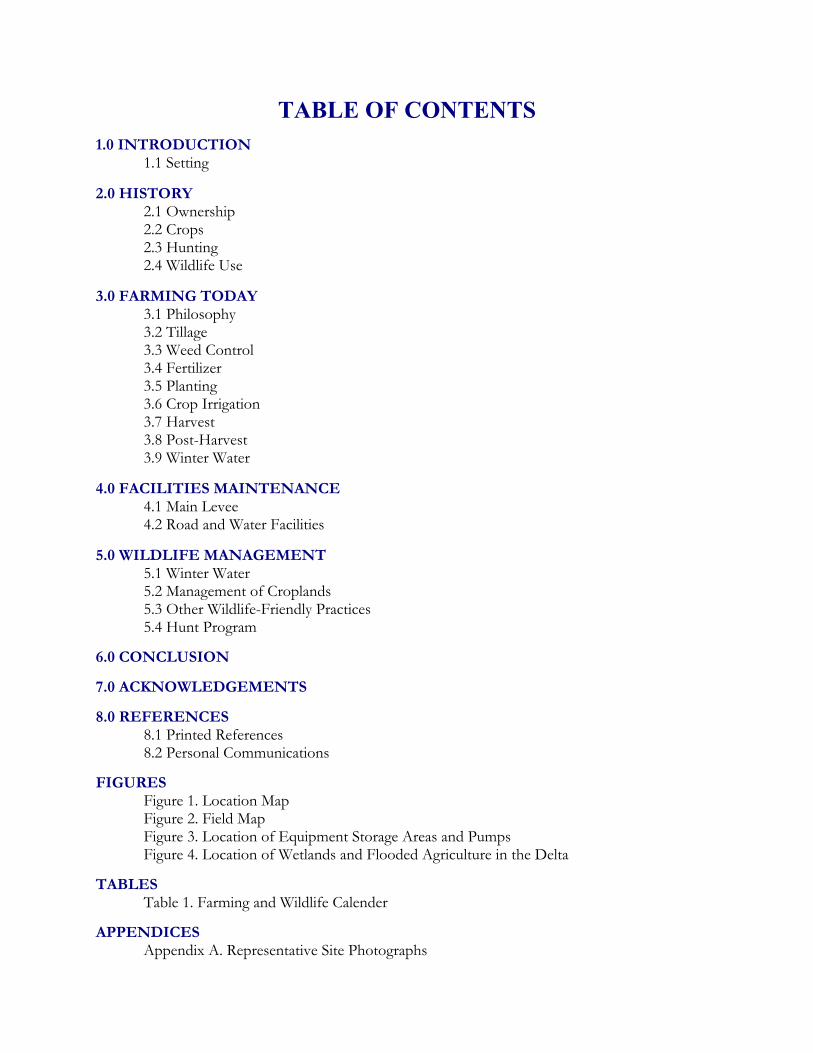
TABLE OF CONTENTS1.0 INTRODUCTION
1.1 Setting
2.0 HISTORY2.1 Ownership2.2 Crops2.3 Hunting2.4 Wildlife Use
3.0 FARMING TODAY3.1 Philosophy3.2 Tillage3.3 Weed Control3.4 Fertilizer3.5 Planting3.6 Crop Irrigation3.7 Harvest3.8 Post-Harvest3.9 Winter Water
4.0 FACILITIES MAINTENANCE4.1 Main Levee4.2 Road and Water Facilities
5.0 WILDLIFE MANAGEMENT5.1 Winter Water5.2 Management of Croplands5.3 Other Wildlife-Friendly Practices5.4 Hunt Program
6.0 CONCLUSION
7.0 ACKNOWLEDGEMENTS
8.0 REFERENCES8.1 Printed References8.2 Personal Communications
FIGURESFigure 1. Location MapFigure 2. Field MapFigure 3. Location of Equipment Storage Areas and PumpsFigure 4. Location of Wetlands and Flooded Agriculture in the Delta
TABLESTable 1. Farming and Wildlife Calender
APPENDICESAppendix A. Representative Site Photographs

1
1.0 INTRODUCTION
This report was prepared to document the past and present farming operations on Staten Island in theSacramento-San Joaquin Delta (Delta) of California and to specifically relate these operations to thesuccesses in “wildlife-friendly” farming on the island. Agricultural conversion of the rich bottomlandsand marshes of the Sacramento-San Joaquin Delta began with the passage of the Swamp and OverflowAct shortly following the California Gold Rush in 1850 (Delta Protection Commission 1994). Largeareas of the Delta’s natural habitats were diked and drained (i.e., reclaimed) and converted to some ofthe richest farmland in the world. The undeniable productivity of Delta farmland is only rivaled by itspast productivity as natural wetland habitat that supported greater numbers and variety of resident andmigratory fish and wildlife than currently found in the Delta.
At present, the Delta region supports over 500,000 acres (202,429 ha) of agricultural land, most of whichwas formerly wetland habitat consisting of either riparian or seasonal and perennial marsh communities.Staten Island, located within the Delta in the floodplain of the Mokelumne river system, was historicallyprimarily composed of perennial marsh, which was reclaimed for agriculture (Soil Conservation Service1993). Flood control on the Mokelumne River upstream of Staten Island curtailed seasonal floodingof riparian and other floodplain habitats and allowed conversion of many floodplain areas to agriculturaluses such as tomatoes, grains, and orchards. Tomato production was a key agricultural commodity tothe east of Staten Island and was also a key component of agriculture in the Sacramento Valley untilmarket forces caused a drop in prices in the early 1990s (Delta Protection Commission 1994). The dropin tomato prices fostered a conversion of agricultural lands in the Delta to other crops, including winegrapes. Between 1976 and 1993 nearly 4,500 acres of new orchards and vineyards were introduced tothe Delta region replacing either “native” lands or other intensively farmed areas (i.e., tomatoes)(Department of Water Resources 1993). As a result of past and present agricultural conversion, manyof the wintering areas that migratory waterfowl and wading birds depended on in this portion of thePacific Flyway have been lost. Because the vast majority of historic natural wetland habitats have beenlost to agricultural uses the agricultural lands are left to fill the wildlife habitat void where possible. Someagricultural areas (e.g., orchards, vineyards, turf farms)are not able to provide suitable habitat formigratory birds; however, sites producing row or field crops are often flexible enough in croppingpatterns and management options to provide some form of habitat during part of the year.
At Staten Island, the farm managers have been engaged in a long-term effort to tailor the farmingoperations and practices so that the island’s agricultural operation is economically viable while providingabundant wildlife values during critical periods of the year. The successes from both an agricultural aswell as a wildlife habitat standpoint have resulted in Staten Island often being cited as a prime exampleof what is frequently referred to as “wildlife-friendly farming.” This report documents the history ofagricultural operations at Staten Island and also describes the practices, operations, and maintenanceactivities that have helped create the unique blend of viable agriculture and wildlife habitat that we seeon Staten Island today.
1.1 SETTING
Staten Island is located within the Delta between the North and South Forks of the MokelumneRiver, near Walnut Grove in San Joaquin County (Figure 1). Currently owned by The NatureConservancy and operated by Conservation Farms and Ranches, Inc., a non-profit affiliate of
2
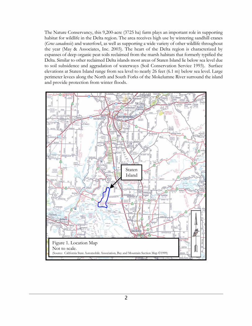
The Nature Conservancy, this 9,200-acre (3725 ha) farm plays an important role in supportinghabitat for wildlife in the Delta region. The area receives high use by wintering sandhill cranes(Grus canadensis) and waterfowl, as well as supporting a wide variety of other wildlife throughoutthe year (May & Associates, Inc. 2003). The heart of the Delta region is characterized byexpanses of deep organic peat soils reclaimed from the marsh habitats that formerly typified theDelta. Similar to other reclaimed Delta islands most areas of Staten Island lie below sea level dueto soil subsidence and aggradation of waterways (Soil Conservation Service 1993). Surfaceelevations at Staten Island range from sea level to nearly 26 feet (6.1 m) below sea level. Largeperimeter levees along the North and South Forks of the Mokelumne River surround the islandand provide protection from winter floods.
Figure 1. Location MapNot to scale.(Source: California State Automobile Association, Bay and Mountain Section Map ©1999)
StatenIsland
3
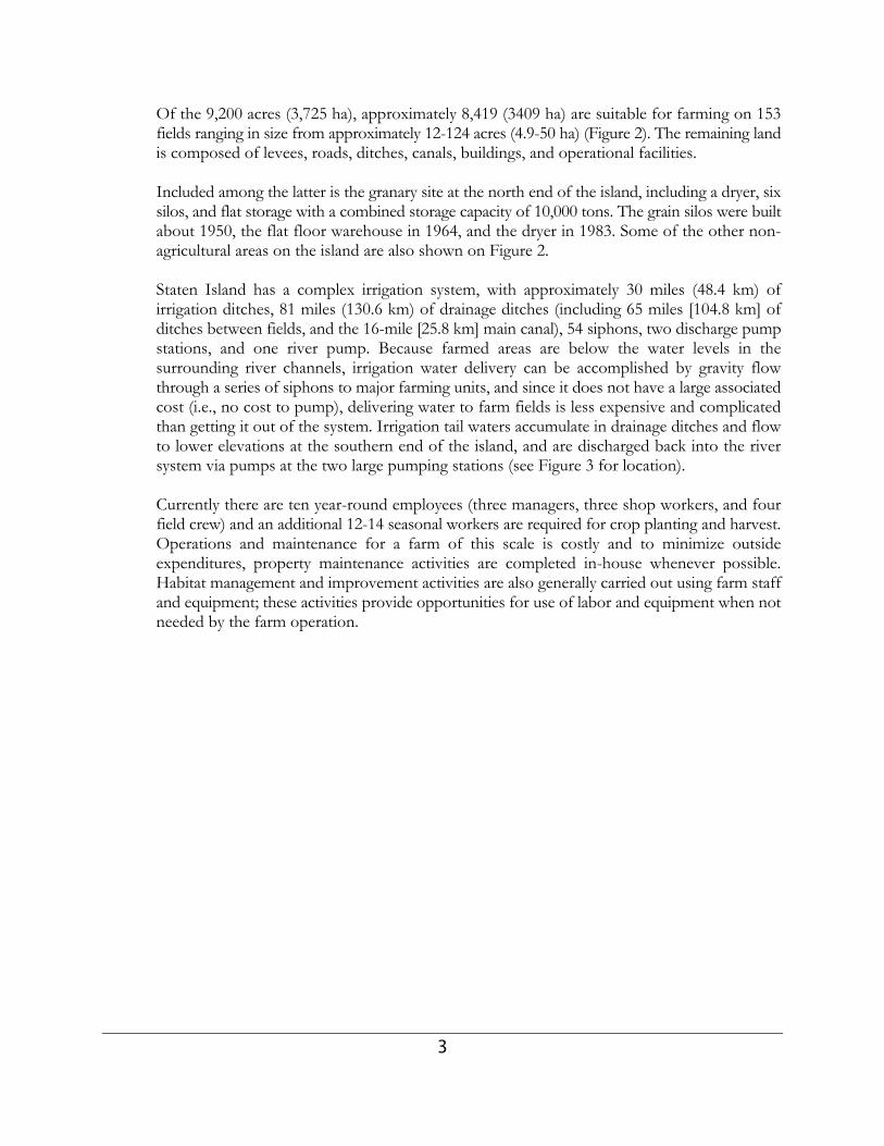
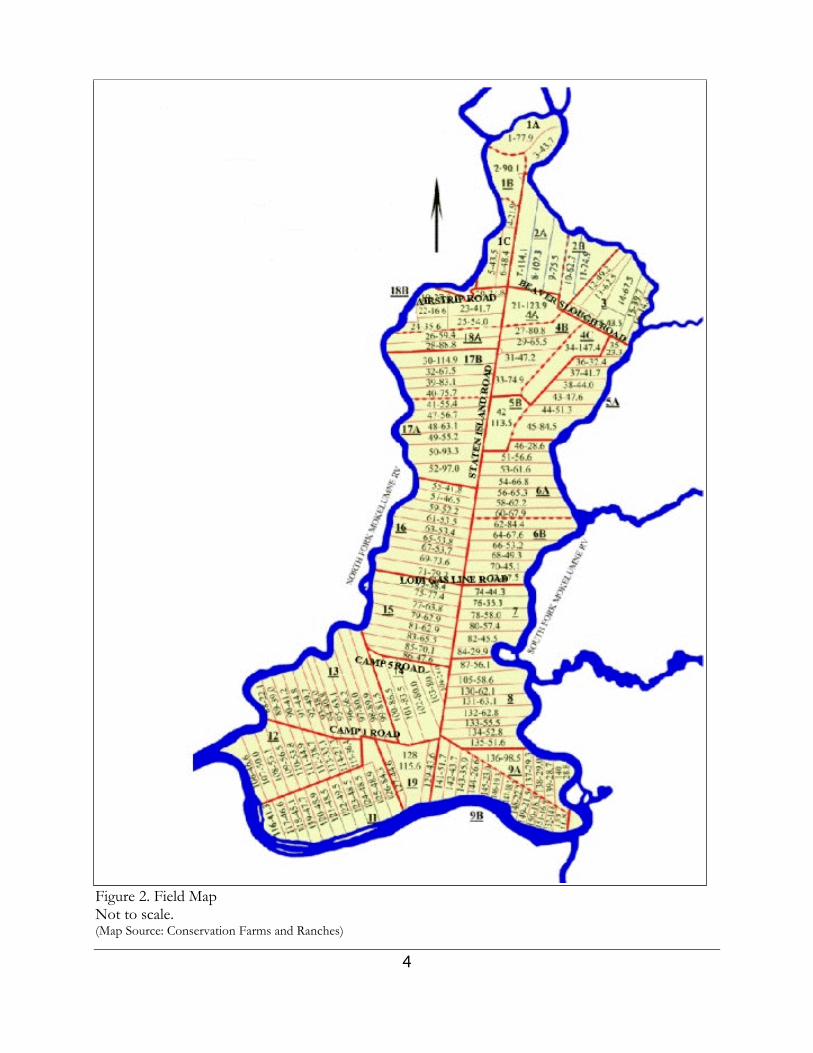
Of the 9,200 acres (3,725 ha), approximately 8,419 (3409 ha) are suitable for farming on 153fields ranging in size from approximately 12-124 acres (4.9-50 ha) (Figure 2). The remaining landis composed of levees, roads, ditches, canals, buildings, and operational facilities.
Included among the latter is the granary site at the north end of the island, including a dryer, sixsilos, and flat storage with a combined storage capacity of 10,000 tons. The grain silos were builtabout 1950, the flat floor warehouse in 1964, and the dryer in 1983. Some of the other non-agricultural areas on the island are also shown on Figure 2.
Staten Island has a complex irrigation system, with approximately 30 miles (48.4 km) ofirrigation ditches, 81 miles (130.6 km) of drainage ditches (including 65 miles [104.8 km] ofditches between fields, and the 16-mile [25.8 km] main canal), 54 siphons, two discharge pumpstations, and one river pump. Because farmed areas are below the water levels in thesurrounding river channels, irrigation water delivery can be accomplished by gravity flowthrough a series of siphons to major farming units, and since it does not have a large associatedcost (i.e., no cost to pump), delivering water to farm fields is less expensive and complicatedthan getting it out of the system. Irrigation tail waters accumulate in drainage ditches and flowto lower elevations at the southern end of the island, and are discharged back into the riversystem via pumps at the two large pumping stations (see Figure 3 for location).
Currently there are ten year-round employees (three managers, three shop workers, and fourfield crew) and an additional 12-14 seasonal workers are required for crop planting and harvest.Operations and maintenance for a farm of this scale is costly and to minimize outsideexpenditures, property maintenance activities are completed in-house whenever possible.Habitat management and improvement activities are also generally carried out using farm staffand equipment; these activities provide opportunities for use of labor and equipment when notneeded by the farm operation.
4
Figure 2. Field MapNot to scale.(Map Source: Conservation Farms and Ranches)

5
Figure 3. Location of Equipment Storage Areas and PumpsScale: 1:56,000±

6
2.0 HISTORY
The history of Staten Island roughly parallels that of much of the Delta region with complete conversionfrom marshland to agricultural production (i.e., reclamation) occurring gradually over the mid to late19th century. Crops grown on Staten Island have varied over time with perhaps the most diversifiedproduction occurring when multiple tenants farmed the island in the late 19th and early 20th Centuries.The advent of modern farming equipment, pesticides, and herbicides has allowed Staten farm managersto specialize, producing fewer crop types with higher yields on a rotational basis. Although somewildlife use of Staten Island’s agricultural landscape occurred historically, management of the island forwildlife use was not a priority until recently. Additionally, similar to other areas of the Delta, waterfowland upland game (i.e., ring-necked pheasant) hunting were historically recreational uses of Staten Island. The following section briefly elaborates on the ownership history, cropping patterns, historical huntingpressure, and wildlife use of Staten Island following reclamation.
2.1 OWNERSHIP
Staten Island has been farmed since 1868 when the Kern Land Company began to reclaim theisland’s swampy marshland. Reclamation continued into the late 19th Century, with multipletenants farming up to 38 camps (farming units). In 1939, Staten Island came under singleownership when M & T Incorporated purchased the island, and over time took over all activefarming operations. Jim Shanks, the current manager, began working on Staten in 1952, andbecame manager in the early 1970s. In 1984, KKR (a leverage buyout firm) purchased StatenIsland on behalf of Pacific Realty Trust, LP (PacTrust) with the idea that they would make aprofit by subdividing the island into several large farming parcels and selling them to one ormore separate entities. At that time Jim Shanks realized that Staten’s wildlife value was beginningto rival its value for agriculture, and was able to convince PacTrust that keeping the island insole ownership would yield a superior investment opportunity while also better enabling thecontinuation of wildlife habitat value enhancement.
2.2 CROPS
Historical crop production paralleled much of the rest of the Delta islands and was diversified,with Staten Island producing asparagus, tomatoes, sugar beets, and fruit orchards, with smallareas of corn and wheat. Asparagus production was very labor intensive and the culture andharvest employed up to 300 workers at the south end of the island, however, in the late 1970s,asparagus canneries and local freezers abandoned the Delta region because of marketconditions, and in combination with the complications of managing such a large group oflaborers, lowered the profitability of growing this crop.
Following the downturn in local asparagus markets the major tomato markets shifted to thesouth of the state, while sugar beets became too labor intensive to grow in a cost effectivemanner on Staten Island. Historically, potatoes were also tried, but were affected by competitionwith weeds. Safflower was also attempted, but didn’t work well as it required dry field conditionslate in the growing season to allow the seeds to dry on the plant which resulted in increasedoxidation of the peat soils. Before the availability of modern herbicides, corn was difficult togrow because of competition with dense stands of Johnson grass (Sorghum halepense).
7
Advances in farm machinery combined with the increasing cost of labor made crops whichcould be harvested using a combine (i.e., grains) more profitable, as much less labor is neededfor harvest. Consequently, farming shifted primarily to corn and wheat in the 1970s, but wheatprices plummeted in the 1990s, causing an increase in the amount of corn planted.
For several years, an experimental rice program of 15 acres (6 ha) was conducted on the islandby the Rice Foundation. Rice has not been grown commercially on Staten because profitabilityof the crop relies heavily on government subsidies and it has traditionally been over-producedin California. Additionally, growing rice on Staten Island would compete with farmers in theSacramento Valley whose crop options are very limited due to heavy clay or hardpan soils.Conversion to rice is expensive because fields need to be laser-leveled and rice strawdecomposition practices (i.e., burning, rolling, flooding) would need to be implemented, and thecrop’s high water needs would result in increased tailwater pumping costs. However, it isnoteworthy that when the small area of rice was grown on Staten, it was very attractive to duckbroods.
2.3 HUNTING
Sometime before 1952 through about 1974, Staten Island was leased to the CaliforniaDepartment of Fish and Game as a public waterfowl and pheasant hunting area, hosting up to300 hunters per day. This intense level of hunting pressure essentially kept waterfowl and cranenumbers very low, with only small numbers of cranes (about 200) using the safety zone (closedarea). In the mid-1970s, after the public hunting program was terminated because administrationfunds were cut, hunting became much more restricted by the farm manager in terms of numbersof hunters, time, and areas open to hunting (see Section 5.4 Hunting).
2.4 WILDLIFE USE
Prior to reclamation Staten Island likely supported expanses of permanent marsh, pockets ofriparian scrub, and several meandering smaller sloughs. Soil survey data (Soil ConservationService 1993) suggests that the southern 3/4 of Staten Island was dense permanent marsh withseveral small dead-end sloughs. The northern 1/4 of the island was probably a mosaic ofpermanent marsh and riparian scrub. Semi-permanent marsh was probably limited in this areaand seasonal marsh was scarce. The island’s habitats supported a diverse assemblage of residentwildlife and the open water areas of the marsh likely attracted migrating waterfowl in greatnumbers. Following reclamation, farming land on Staten Island probably flooded relativelyregularly during the winter due to the primitive nature of levee and drainage systems in the late19th and early 20th centuries. However, flooding probably only occurred following major stormor flood events that overwhelmed the Island’s drainage or levee systems and no longer followedthe natural hydrologic regime of the Delta. As levee and drainage technology improved theunintentional deep flooding of Delta islands was greatly reduced; however, the intentionalshallow flooding of Delta islands for a variety of purposes (e.g., weed control, salt leaching,waterfowl hunting, and wildlife habitat) has been commonplace for nearly the past 70 years(Delta Protection Commission 1994).
The expansion of grain crop acreage in the 1970s, coupled with the reduced disturbance that

8
resulted from single-ownership farming and careful management of the hunting program, leadto substantial increases in crane and waterfowl use on Staten Island in the late 1970s and 1980s.During this same time period, cranes were losing traditional roost and forage areas due to landconversion to vineyards and orchards. Because of the large numbers of sandhill cranes andwaterfowl using the Island, it was recognized as an important site by the Central Valley HabitatJoint Venture (Joint Venture) and Ducks Unlimited, Inc. (DU) in the early 1990s. Jim Shanks then relied on the advice of several wildlife authorities, including Roderick Drewien, arenowned sandhill crane biologist, David Paullin with the Joint Venture, Ed Collins and FritzReid of DU, and David Yee of the Stockton Audubon Society, to improve wildlife managementon Staten Island.
9
3.0 FARMING TODAY
3.1 PHILOSOPHY
Since shifting primarily to grain production in the 1970s (and a long-term commitment reflectedin installation of the grain dryer in the 1980s), Staten Island management has focused oncarefully planning and managing operations with the combined goal of improving efficiency andprofitability and enhancing wildlife values. In contrast to mainstream farming philosophy, JimShanks strives to find a middle ground between farming and environmental goals. Finding thebalance between profitable farming and wildlife habitat is an ongoing process and is beingconducted using an adaptive management approach. The current farming program includes6,800-7,000 acres (2,753-2,834 ha) of corn, 1,000-1,200 acres (405-486 ha) of wheat, and about500 acres (202 ha) of tomatoes. Genetically modified crops have not been planted. Tomatoesare grown and harvested by a tenant farmer, while Staten Island employees grow and harvestthe grain crops.
Two major corn types have traditionally comprised the bulk of the crop, and include both short-and long-season varieties. Additionally, several experimental types of corn are tested each year.Because of the on-site storage facilities it is possible to maximize profit through a combinationof pre-selling (i.e., selling prior to harvest) and post-harvest storage to take advantage of seasonalprice variations outside the traditional harvest season.
Table 1 illustrates and summarizes the typical farming and wildlife activities on a month-by-month basis on Staten Island, however, farming activities may vary from year to year by as muchas a month, depending on field conditions, market conditions, and management considerations.
3.2 TILLAGE
Field tillage (i.e., the cultivation and preparation of a field’s soils for planting) is a criticalcomponent of any farming operation and can greatly influence the yield from the crop that willbe planted that year as well as the yield that the field will produce in the years to come. Afarmer’s tillage choices can also have an effect on overall profitability because each tillage system(e.g., conventional tillage, conservation tillage, no-till method, etc.) has an associated labor, fuel,and equipment cost that must be considered alongside of the potential yield benefit. At StatenIsland, Jim Shanks has been incorporating conservation tillage system principles whereby cropresidues are left on the fields covering a third or more of the soil surface resulting in benefitsfor wildlife (i.e., crop residue for food) as well as the farming operation as a whole (i.e., reducedlabor and fuel costs, better soil tilth, reduced wear on machinery). Additionally, within thetillage system there is an assortment of tillage equipment that can be used (i.e., plows, chisels,harrows, etc.), each with distinct advantages as well as disadvantages.
Which tillage system and/or equipment to use and when requires careful consideration of anumber of variables including field condition, labor and fuel costs, equipment availability,climate conditions, and market conditions. On Staten Island, Jim Shanks is also adding anothervariable to the tillage decision, wildlife habitat management. Tillage begins when the fields areprepared for planting, and to be ready for planting a field must be clear of weeds and any crop
10
residue that could interfere with seeding. Currently, disk-harrowing and ripping are the primarycultivation methods used at Staten Island, however, chopping, chiseling, and plowing are alsoutilized. Each of these methods is briefly described below:
♦ Disk harrowing chops and rolls the upper soil 6-8 inches (15-21 cm) deep and buries cropresidues and weeds; requires large and powerful equipment to be efficient on a large scale(i.e., wide pass needed to offset slow speed); moderately expensive.
♦ Ripping uses long steel shanks to lift the soil, helping to aerate and reduce compaction,however, it does not turn the soil over and thereby leaves the crop residue on the soilsurface; least expensive method. Tomato fields are typically ripped because of thecompaction caused by harvesting equipment.
♦ Chopping is not a soil tillage method but rather a crop residue management method. Chopping involves cutting and chopping post-harvest residue near ground level and leavingthe material on the soil surface as a layer of mulch to decompose over the winter; lower costthan disking in residue.
♦ Chiseling uses a chisel plow to penetrate and break up the compacted soil surface usingvibration while leaving crop residue on the soil surface; different chisel point shapes andsizes can be used to vary degree of soil aeration/turning. Moderate power and fuelrequirement; lower cost than disking or plowing but does not turn over soil.
♦ Plowing lifts and turns over the soil (at a greater depth than a disk harrow) and is used toincorporate crop residue into the soil, aerate the soil, control weeds, and prepare theseedbed. Because of their high power requirement, plows are often narrow and must beoperated at a slow speed; high fuel consumption and greater than average tractor wear resultin high costs.
On Staten Island fall chopping of corn residue (i.e., stalks, etc.) has been used extensively forthe past two years (2001-2002). This practice results in a layer of crop residue on the soil surfacethat includes residual grain, once flooded or saturated this residue slowly decomposes releasingnutrients into the soil. As an added benefit, the chopped residue that is left on the soil surfacecontains residual grain and provides habitat for the growth of some invertebrates, both of whichserve as foods for some wintering birds. The residue also provides a protective barrier for thesoil, reducing the chance for wind or water erosion. Fall chopping of the corn allows much ofthe crop residue to decompose on the soil surface thereby minimizing the need for tillage suchas plowing and disking to incorporate a large amount of residue. Chopping is also inexpensivein comparison because the equipment (essentially a large header/chopper on a combine) has awider pass (24 ft [7.3 m]) than a disk harrow or plow. Chopped crop residues can also helpsuppress weed growth because the mulch restricts the amount of light reaching the soil surface.
In the beginning of the planting season rolling a heavy imprinter or incorporator over choppedfields pushes remaining residues beneath the soil and corrugates the soil surface, making the soilless likely to blow away. In contrast, plowing to incorporate crop residue digs about 16 inches(41 cm) deep and mixes soil horizons, and equipment is only eight feet (2.4 m) wide; it is themost costly in terms of hours, fuel, and tractor wear, and therefore is only used when necessary(e.g., heavy soil at the north end of the Island when it is compacted or for hard to work wetsoils). Since new corn planting equipment uses forced air technology, it is more tolerant of thepresence of crop residues, and chopping and chiseling have become more compatible; in 2003,these practices reduced spring tillage by 50% (compared to spring plowing of unchopped
11
residue), saving fuel and labor. From a labor and timeliness standpoint the benefits of choppingare clear because about 250 acres (101 ha) of corn stubble can be chopped by one operator inone day following harvest, while only 110 acres (45 ha) of corn stubble could be disced orchiseled, and only 35-40 acres (14-16 ha) could be plowed.
3.3 WEED CONTROL
Because of the exceptional moisture-holding capacity of Staten’s organic soils, weed control isa major challenge to growing a successful crop. However, some plant species deemed weedy ina crop producing area can actually provide habitat for resident wildlife in non-crop producingareas (i.e., ditches and field edges). There is a delicate balance between managing for high cropyields while providing for some wildlife habitat and cover bordering the fields. If leftunchecked, some of the noxious weeds growing adjacent to the fields can rapidly becomeserious pests within the cropland. The managers at Staten Island help maintain this balance bycarefully timing herbicide application so that efficiency is maximized in cropped areas which inturn minimizes chemical, fuel, and labor expenses. Additionally, effective herbicide use reducesthe need for repeat or rescue applications that can result in additional chemical inputs to the air,soil, and water that may potentially affect the natural environment. In addition to herbicideapplication, weeds have also been managed using tillage, sheep and horse grazing, and flooding.
For corn field preparation, Roundup® is used in most areas in February following field drainingin lieu of discing, as it is less expensive and because fields may be too wet for heavy equipmentaccess. Using Roundup for weed control is also favored over discing because it leaves consistentmoisture across fields, and discourages birds from initiating nests (i.e., no suitable cover fornesting) where they might be lost when planted. Up to 80% of the corn seed is pre-treated withGaucho® (a systemic insecticide) and therefore no insecticide is needed at planting for thisportion of the crop.
Historically, large amounts of pre-emergent herbicides were used for weed control in the springprior to planting. Operations changed to a primary use of post-emergent herbicides in the early1990s with the development of Accent® for weedy grass control in corn, and in particular forcontrol of Johnson grass (Sorghum halepense), a major problem weed in the Delta. Because ofAccent‘s® efficacy, much less chemical is used today than was in the past (i.e., ounces vs. gallonsper acre). Today, a total of 7,500 acres (3,036 ha) is treated with one sprayer by one operator,saving twice as much labor and three times as much horsepower and fuel.
The herbicide tank mix and application rate varies according to the weeds targeted at a givensite. Clarity®, Permit®, and Lasso® are also mixed with Accent® for post-emergence broadleafcontrol in corn. Roundup® is also used for broad spectrum weed control. 2,4-D® is used forbroadleaf weed control after the wheat is growing. Roundup®, 2,4-D®, and Garlon® are alsoselectively applied to problem sites in non-crop areas.
Ditches adjacent to corn fields are initially sprayed with Accent® to control broadleaf weeds asmany corn varieties are not affected by this herbicide. Weedy vegetation along ditches is thenleft to grow to provide cover for wildlife unless noxious weeds develop. In wheat fields, 2,4-D®
is applied by aircraft in January to control broadleaf weeds in the young wheat. Use of pesticidesin tomato fields is more complicated, with pre- and post-emergent herbicides and insecticides
12
used. Spot spray control of weeds with tomatoes occurs throughout the growing season.
As mentioned previously, non-crop areas (i.e., field borders, ditches, etc.) treated with herbicidesprimarily include areas where the weeds present have potential to negatively affect the adjacentcrops. The main levee on Staten Island comprises the largest non-crop area on the Island andweed management is an important issue especially as it relates to levee integrity and the need forvisual inspections. Staten Island managers have been implementing a program of sheep andhorse grazing to help manage weeds. Sheep grazing on the main levee begins in late May (aftermost bird nests have hatched), south of the areas used for horse pastures on the northern halfof the Island. After crop harvest, sheep are moved to wheat fields which are planned forflooding. As wheat fields are flooded the sheep are rotated into harvested corn fields that arenot planned for flooding that year. Sheep are removed from the Island in October around thetime of the first frost (typically in mid-November [Soil Conservation Service 1993]).
Where possible, flooding of fields is also used through the winter as a weed control method, butbecause the fields are not completely level, water depths vary across the field, complicating weedcontrol as some weed species can germinate and grow in shallow water. Therefore, some spotspraying is periodically needed in problem areas. Light disking is used in some wheat fieldswhere water is too shallow to control weeds, and as mentioned previously, in some corn fieldsbefore spring planting.
3.4 FERTILIZER
In corn fields, liquid nitrogen (UN-32) is injected up to two weeks before planting, and starterfertilizer (8-24-6) is injected with seeds during planting. Wheat fields are fertilized as planted(also with 8-24-6). In contrast, tomatoes require larger amounts of fertilizer, both before andduring planting, and when plants are about 10 inches (26 cm) high. UN-32 fertilizer is used inpreference to ammonium nitrate because of worker safety concerns.
3.5 PLANTING
The selection of fields for specific crops is a complicated, yearly decision, based on irrigationand drainage blocks, summer leveling needs, rotations for weed control, and the placement ofwheat in areas that can be used for early roost water for cranes. Corn planting begins in earlyApril and continues for about 40 days. Tomatoes are planted from mid-April through mid-May.Winter wheat is usually planted in November or December, just before the normal period ofheavy fall rains.
3.6 CROP IRRIGATION
Tomato and corn crops are sub-irrigated three to four times during the growing season by fillingin-field ditches with repeated irrigations beginning the end of May, and occurring about two tothree weeks apart through mid-August. Irrigation is conducted slowly for deep saturation. Sub-irrigation also generally results in reduced weed infestations. Lower elevation fields at thesouthern end of the Island are not irrigated as much as the other parts of the Island, as theyreceive subsurface water from the river (subbing) and their associated ditches function mostlyas drains, not water delivery. Winter wheat generally receives sufficient moisture from rainfall

13
and supplemental irrigation is not necessary. The ditches in wheat fields serve primarily to allowfor drainage. However, in drought years, V-ditches are used to irrigate wheat.
3.7 HARVEST
Winter wheat is harvested in mid-July, and tomatoes in mid- to late-August through earlyOctober. Corn is harvested from early September through October, and usually begins at thenorth end of the Island and proceeds south. Corn harvest used to begin in mid-September andcontinue through November. However, since the price for corn is better early in the seasonbefore market saturation, harvest now starts in early September when possible, and is finishedby late October, resulting in a higher profit.
Within each corn field, headlands (field ends) are harvested first and disked to allow heavyequipment and truck access, and harvest usually proceeds from the center of the field to theends. After harvest, residual stubble heights are typically 24 inches (62 cm) for corn and 16-18inches (41-46 cm) for wheat. Corn harvest used to begin in mid-September and continuedthrough November. However, since the price for corn is better early in the season beforemarket saturation, harvest now starts in early September when possible, and is finished by lateOctober, resulting in higher profit. Because of the early harvest on Staten Island about 25,000tons of corn is harvested before other local farmers begin. Because more trucks are availableearly in the season and buyer’s storage areas are empty, Staten Island can deliver 40-50 loads ofcorn a day, compared to other farmers who typically only haul one load per day during peakharvest season. From the field, corn is transported to the dryer and from there to storage. Earlyin the harvest, corn is moved out of storage to buyers as quickly as possible. Approximately2/3-3/4 through harvest, out-shipments from storage end and the remaining corn harvested isstored then sold in the spring. The large drier at the mill allows this massive harvest and storageprogram that is the key to maintaining a good profit from corn. It is only by growing corn involume and minimizing expenses that grain production at Staten Island is profitable.
3.8 POST-HARVEST
About half of the acreage of harvested corn fields are chopped after harvest and generally, everyother field is chopped. Wheat stubble is usually ripped if the field is to be leveled for the nextseason. Wheat stubble remains unmanipulated in fields planned for winter flooding. Tomatofields are deeply ripped to reduce soil compaction (immediately prior to spring fieldpreparation).
To allow winter flooding of all three crops, temporary levees are pushed up with a CaterpillarD6H bulldozer, and a backhoe is used to install water control structures. Field leveeconstruction takes one operator about one month to complete. Some limited flooding beginsin harvested wheat fields before early September to accommodate the arrival of cranes, butflooded acreage increases rapidly as the harvest concludes and staff time can be allocated tobuilding levees in corn and tomato fields.
3.9 WINTER WATER
Some flooding begins in harvested wheat fields in early September to accommodate the arrival

14
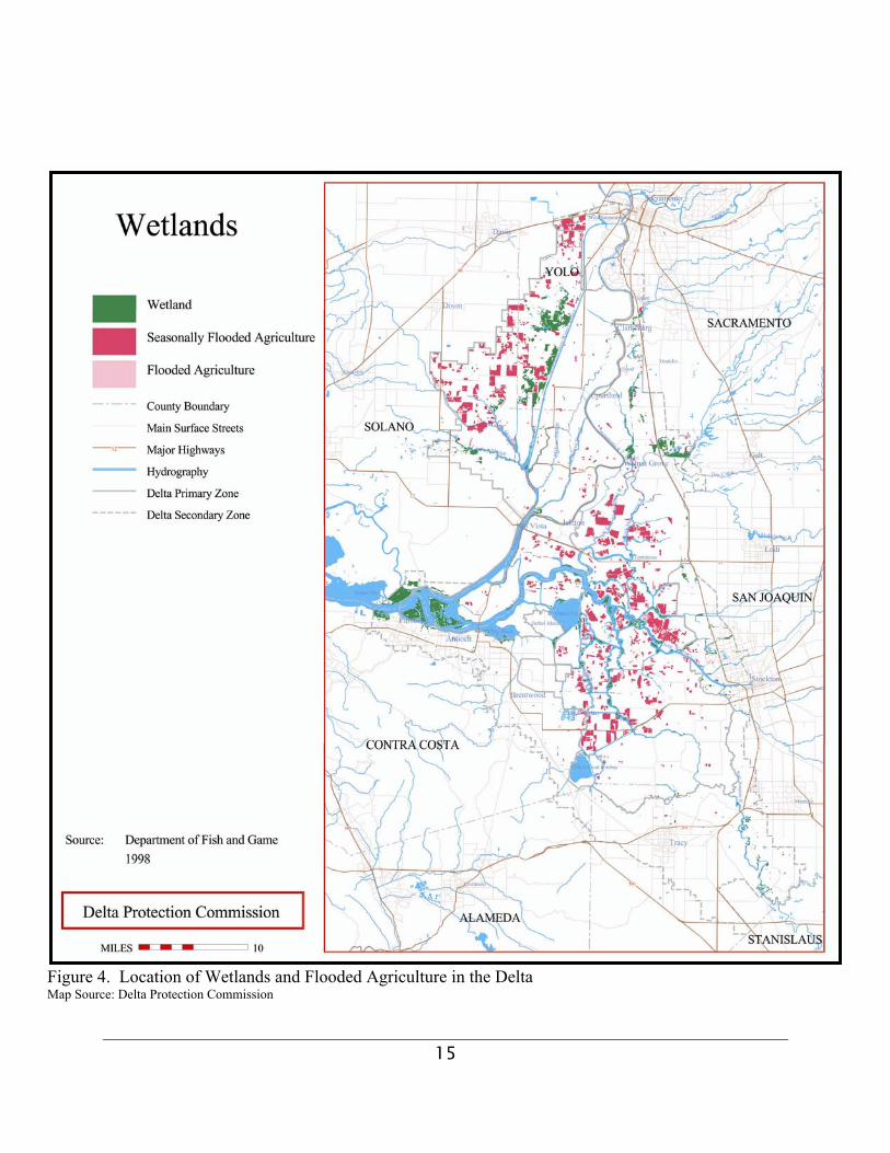
of cranes, but acreages increase as the corn and tomato harvest concludes and more staff timecan be allocated to building levees. Flooding of fields provides habitat for cranes, waterfowl,shorebirds, and other waterbirds. Agricultural benefits include weed control, prevention of soiloxidation and subsidence, decomposition of crop residues, and leaching of salts (which cansignificantly decrease crop yields). Flooding also improves soil texture, which in turn enhancesyields. In the Delta region flooding of agricultural land for wildlife habitat, hunting, and soil saltmanagement has been occurring on a fairly large scale (Figure 4) for many years (DeltaProtection Commission 1994) and Staten Island fits prominently in the big picture. Floodingover the winter also helps maintain soil moisture after fields are drained, aiding in germinationof the next crop.
Ideally, it would be beneficial to rotate winter flooding to all the fields around Staten Island sothat each field received a flooding treatment about every three years. However, this isimpractical given the present configuration of water management facilities on the Island.Flooding requires construction of temporary in-field levees, and fields west of Staten IslandRoad (the main gravel road down the center of the Island) are more economical to floodbecause the roadbed serves as a low levee and therefore only sideboard levees need to be built.In contrast, much more levee work is required to flood fields on the east side of Staten IslandRoad because a temporary low levee has to be built along the large drain that parallels StatenIsland Road.
Water depths in flooded fields range up to about 2.5 feet (0.8 m), but the vast majority are lessthan one foot. Levels are sometimes drawn down in selected fields and then refreshed with newwater, which helps flush salts from the soil, provides high quality late water, and helps tomanage potential bird disease outbreaks such as avian cholera.
15
Figure 4. Location of Wetlands and Flooded Agriculture in the DeltaMap Source: Delta Protection Commission
16
4.0 FACILITIES MAINTENANCE
Over 800 acres (324 ha) of non-cropland areas on Staten Island require maintenance. Most of this areaconsists of narrow ribbons of roadway, ditches, and levees with a smaller proportion consisting ofbuildings, homes, and staging areas. These areas all form the habitat linkages between farmed habitats(i.e., fields) and the natural habitat along the two forks of the Mokelumne River. Managers at StatenIsland have been managing these facilities from the perspective that they must reliably provide theirrespective functions; however, some balance can be achieved to benefit resident and migratory wildlife.The general activities associated with the important task of maintaining the island’s main levee, roadsand water conveyance system (i.e., ditches) are described below.
4.1 MAIN LEVEE
Because Staten Island lies mostly below sea level and surrounded by the North and South Forksof the Mokelumne River, there is the constant threat of flooding, which makes monitoring andmaintenance of the main levee a critical task. Flood concerns continue to grow as urbandevelopment accelerates within the watershed of the Cosumnes and Mokelumne Rivers,hardening the watershed and increasing runoff. The outside (i.e., water side) of the main leveealong both forks of the river is reinforced and maintained with rock riprap to minimize erosionprimarily from wave action from recreational boating, but because the North Fork on the westside is larger and wider and experiences higher flows, it requires more maintenance. While treesand shrubs along the outside of the main levee occasionally need to be removed, this is onlydone when necessary to accomplish a levee rehabilitation project.
On the inside of the levees, a one disc-wide area (8 feet [2.4m]) is kept clear of vegetation at thebase to allow monitoring for leaks during periods of elevated river levels. Grass is encouragedalong the sides of the levee, but broadleaf weeds are treated with herbicides, applied by aerialapplication of 2,4-D® in February. Some spot-spraying (mostly just after harvest) of Roundup®
on bermuda grass (Cynodon dactylon) is conducted as needed to keep it from spreading to theagricultural fields. The road on the top of the levee is occasionally mowed in spring to keepvegetation short to reduce fire hazard. As mentioned previously in the weed control discussion,sheep and horse grazing are also employed to reduce the potential for fire, and to keepvegetation at a low profile to make it easier to find leaks. Sheep-use patterns vary yearly, butcover much of the island, while horses are rotated among seven pastures at the north end.Overall the vegetation maintenance strategy that Staten Island managers have adopted forlandside levee vegetation is to allow for maximum upland nesting and cover during the timeswhen cropland is not hospitable but in the course of the year vegetation will eventually need tobe removed to accommodate inspections.
Vertebrate pest control on the island includes control measures for coyotes (Canis latrans) andCalifornia ground squirrels (Spermophilus beecheyi), which can threaten the integrity of the mainlevee with their burrowing and denning activities. Eradication of these species is not necessary;however, control is necessary to maintain populations at acceptable levels. Coyotes aredispatched on an opportunistic basis, while poison bait stations are placed in plastic PVC pipesdistributed along the levee for ground squirrel control. Muskrats (Ondatra zibethicus) are notcontrolled, although they can damage small levees, resulting in the loss of winter water.

17
4.2 ROAD AND WATER FACILITIES
Gravel roads are graded periodically as needed after rains, in spring before planting starts, andbefore harvest if enough moisture is present. About 60% of the permanent ditches are cleanedduring the winter in a given year, while the main canal is cleaned about every 10 years. Cleaningis necessary to maintain capacity; however, by not cleaning all the ditches annually insures thatsome cover will be available every year.

18
5.0 WILDLIFE MANAGEMENT
The basic needs of wildlife are adequate space, food, water, and cover. During fall and winter, sandhillcranes and waterfowl are very sensitive to human disturbance, which is a major factor influencingwildlife distribution. Management of Staten Island has focused on meeting wildlife requirements on alarge tract of land and limiting disturbance to the extent possible while still maintaining an efficient andprofitable farming program. A variety of wildlife-friendly practices work towards these goals, rangingfrom how water, crops, and weeds are managed, to how the hunting program is practiced.
5.1 WINTER WATER
Because wheat fields are harvested in July, flooding can begin in early September in time forsandhill crane arrival. This also provides habitat for early waterfowl migrants (including northernpintails [Anas acuta] and greater white-fronted geese [Anser albifrons]) and shorebirds. Theflooding up of corn and tomato fields occurs shortly thereafter in October after fields areharvested, where water will not affect standing crops in adjacent fields and when manpower isavailable. In 2002-03, approximately 2,271 acres (919 ha) of croplands were flooded to providefall and winter roosting and foraging sites for cranes, waterfowl, and shorebirds. These areasreceived heavy use by roosting and loafing sandhill cranes and waterfowl throughout the winter.Cranes and shorebirds are very attracted to newly-flooded areas for feeding, as they apparentlyprey on terrestrial invertebrates, such as insects and spiders, which are exposed and concentratedat the water’s edge. In addition, several thousand ducks would flock into flooded corn fields atdusk to feed at night. A few weeks after flooding, high densities of aquatic invertebrates arepresent. Aquatic larvae of midges (Family: Chironomidae) typically are very important fooditems for ducks and shorebirds. Shorebird habitat is enhanced with the gradual flooding anddrawdown of water levels. Because open water areas on Staten Island are not treated formosquitoes during the winter months (J. Stroh pers. comm.), the full complement of aquaticinvertebrates is allowed to develop and the only limiting factor may be the use of insecticidesduring the growing season. However, aerial mosquito surveys conducted during late summerand early fall caused considerable disturbance to cranes loafing in flooded portions of the island,and any spraying after mid-September would likely delay the availability of invertebrates as foodfor wetland birds.
5.2 MANAGEMENT OF CROPLANDS
As touched upon throughout this document, tillage, weed control, planting, irrigation, andharvesting all have a role in the wildlife-friendly management of cropland on Staten Island. With a piece of farmland of this size the wildlife benefits of these management activities wouldnot be fully realized without an exceptional level of coordination between managers, operators,and workers. The current ownership structure (i.e., single owner with centralized management)is a key component in managing for wildlife habitat and reducing disturbance to wildlife fromfarming activities.
Besides the selection of grain crops, chopping of harvested corn stubble makes fields moreattractive to foraging cranes and geese, while unchopped stubble provides some winter cover,which might be important as a thermal refuge for smaller birds. Cranes prefer newly-planted

19
winter wheat, which on Staten is planted at an additional rate of 25 lbs. per acre (25± kg/ha) tocompensate for losses from feeding birds. This level allows for heavy crane use, but still resultsin a good crop yield. Later in the spring, these wheat fields provide nesting cover for ducks,ring-necked pheasants (Phasianus colchicus), and potentially short-eared owls (Asio flammeus), andare harvested after most nests have hatched (i.e., early to mid-July).
Because mallards (Anas platyrhyncos) begin nesting in March before fields are worked up forplanting, Roundup® is applied to most fields to keep weed cover low and create a mulch layerwhich impedes further growth and holds soil moisture. This method reduces cover anddiscourages nesting ducks from using these areas where nests would later be destroyed by tillage.On the main levee, 2,4-D® is used to kill broadleaf weeds and encourage grass cover which isbetter nesting cover for pheasants and ducks and allows for sufficient visibility to allowinspection of the levees.
5.3 OTHER WILDLIFE-FRIENDLY PRACTICES
In addition to the vast nesting and predator escape cover on the main levee, there are two smallfallow fields totaling about 27 acres (11 ha): one at the very southeast corner of the island(adjacent to 9B) (see Figure 3), and the other along the main levee, just north of the BeaverSlough Road to the east of Unit 3. For ducklings, the primary brooding habitat is the island’sditch and canal system; the adjacent river channels are less suitable because of high levels ofdisturbance from boaters. While ditches aren’t ideal duck brooding habitat, as ducklings aregenerally more vulnerable to predators in small confined areas, water levels are held higher inthe ditches during the early growing season to enhance conditions for broods. Irrigation wateris also held longer for broods in corn and tomato fields that are adjacent to wheat fields whichprovide duck nesting cover.
To help duck broods escape predators, ditches are constructed with the needs of broods andother wildlife in mind. In wheat fields, the ditches are V-shaped instead of the steep-sided “spudditch” style typically used by farmers in the region; this shape allows ducks or other wildlife toleave the ditch and hide in nearby cover when predators approach. Generally, ditch-sidevegetation is left for wildlife cover when cleaning ditches, and in some cases, emergentvegetation is also left. Larger ditches are configured to be wider, shallower, and weedier thanmost farmers would tolerate so that the ditches provide habitat for duck broods and otherwildlife, with banks on one side occasionally sloped for wildlife escape. Roads, old culverts, andlevees also provide habitat for potential nesting and wintering burrowing owls (Athenecunicularia). Additionally, dirt road embankments, culverts, and levees provide potential sites fornesting and wintering burrowing owls (Athene cunicularia). The mill and other structures (e.g.,abandoned water tank) provide nesting and roosting sites for great horned owls (Bubo virginianus)and barn owls (Tyto alba).
5.4 HUNT PROGRAM
Recently, waterfowl and pheasant hunting at Staten Island has been conducted under closesupervision by Jim Shanks. Waterfowl hunts in 2002-03 occurred from a series of blinds (abouta dozen) in flooded fields, plus a couple blinds in unflooded corn fields for goose hunting. Onlysix hunters (all employees) were officially assigned to blinds, however, each was authorized to

20
bring a guest, so a maximum of 12 hunters could have been present during the authorizedhunting period. In 2003, hunt days were Saturdays, Sundays, and Wednesdays, but becauseseveral blinds were assigned to employees whose only day off was Sunday, hunting was verylimited. Waterfowl hunting was not permitted after 10:00 A.M., and hunters were stronglyencouraged to be out of the hunt area before this time to minimize conflicts with mid-dayloafing cranes. Pheasant hunts have been carried out by employees and guests in designatedareas on weekends only. This light level of hunting pressure, combined with the 10:00 A.M.cessation of shooting, allowed moderate numbers of waterfowl and shorebirds and highernumbers of cranes to remain, as cranes generally didn’t return to use these flooded areas untilmid-day when hunters were out of the fields. In addition, this hunt program, while very limited,encourages waterfowl dispersal to neighboring properties, likely benefiting huntingopportunities there. Staten Island managers keep close tabs on activities within the island andunauthorized hunting or poaching has not been a problem.
21
6.0 CONCLUSION
Staten’s current management is filling a large and increasing void of wildlife habitat in the Delta wheresubstantial habitat losses have occurred to land conversion to vineyards and orchards (Littlefield andIvey 1999), urban development, and turf farms (Ivey and Herziger 2003). Over time technologicaladvances and changing market conditions have resulted in a wide variety of agricultural commoditiesbeing produced in the fertile soils of the Delta region. At present, California agriculture is at acrossroads, with population growth and suburban sprawl threatening farmland and the pressure forhigher yielding, more profitable crop varieties is requiring the use of more chemicals and geneticallyengineered or manipulated (GMO) crops. Unfortunately, the use of GMO varieties may be limitingCalifornia’s export market, as many overseas markets such as the European Union are leery of GMOproducts. As a consequence of the pressure and difficulty in running a profitable farming operation,many California farmers are opting to sell out to developers or large corporate farming operations. Whether the next landowner is a developer or corporate farmer, neither is likely to be inclined toconduct wildlife-friendly activities without some monetary incentive and direct efforts to educate themabout opportunities and benefits.
The management program developed by Jim and Sally Shanks for Staten Island is a great success fromboth wildlife and farming standpoints, and provides a valuable model for accommodating wildlife in anagricultural landscape. They have been exploring the relationships between wildlife-friendly farming anda profitable farming operation and have found as successful middle ground. Because of this StatenIsland has become a unique example of California agriculture that is immediately applicable toagriculture throughout the Delta region and the Central Valley as a whole. While the natural resourcesof Staten Island (i.e., water, fertile soil, etc.) have contributed greatly to the success of this program, theirfarming philosophy alone can be applied to nearly any agricultural operation in the Central Valley. It is important to continue to explore the relationships that can be fostered between agriculture andwildlife and to employ an adaptive management approach to continue benefiting wildlife whileimproving farming. As the population continues to grow in California and development pressureincreases, Staten Island’s leadership role in the art and science of combining a viable farming operationand wildlife-friendly farming practices will become even more important in maintaining California’s richagricultural and natural heritage.

22
7.0 ACKNOWLEDGMENTS
The primary basis for the discussions in this report is from information provided by Jim and SallyShanks of Staten Island. Additionally, the following individuals provided suggestions on previousversions of this report: Ed Whisler, consulting biologist, Todd Sloat of Sloat Biological Consulting,Keith Whitener, Mike Eaton, and Ramona Swenson of The Nature Conservancy, and Rick Cooper ofBureau of Land Management.
23
8.0 REFERENCES
8.1 PRINTED REFERENCES
Delta Protection Commission. 1994. Background Report on Agriculture, Background Report#4. Reprinted 2001. Delta Protection Commission. Walnut Grove, CA.
Department of Water Resources. 1993. A Report on Land Use Patterns in the Sacramento SanJoaquin Delta. Resources Agency. Sacramento, CA.
Ivey, G. L., and C. P. Herziger. 2003. Sandhill crane monitoring at Staten Island, San JoaquinCounty, California, 2002-03, Unpublished report. The Nature Conservancy, Galt, CA.
Littlefield, C. D., and G. L. Ivey. 2000. Conservation Assessment for Greater Sandhill Craneswintering on the Cosumnes River Floodplain and Delta regions of California. Unpublished report. The Nature Conservancy, Galt, CA.
May & Associates, Inc. 2003. Special-Status Species Survey Report for The NatureConservancy’s Staten Island. Unpublished Report. May & Associates, Inc. WalnutGrove, CA.
Soil Conservation Service. 1993. Soil Survey of San Joaquin County. U.S. Department ofAgriculture in cooperation with University of California Agricultural Extension.Washington D.C.
8.2 PERSONAL COMMUNICATIONS
Stroh, John. Manager, San Joaquin County Mosquito and Vector Control District. Telephoneconversation: 6 August 2003.