farm size holding in northern nigeria: a remote …
TRANSCRIPT

Volume 14 No. 2 April 2014
FARM HOLDINGS IN NORTHERN NIGERIA AND IMPLICATION FOR FOOD SECURITY: A REMOTE SENSING AND GIS ASSESSMENT
Soneye ASO1*
Alabi Soneye
*Corresponding author email: [email protected] 1Department of Geography, University of Lagos, Akoka Yaba Lagos, Nigeria.
1

Volume 14 No. 2 April 2014
ABSTRACT Land is a main life support resource to third world countries. In Nigeria, a major limitation to sustainable land use resources planning, development and management is the unreliable assessment of t available stock and the level of utilization. In particular, the commonly adopted traditional techniques for the evaluation are as questionable as the sources and quality of data adopted and the results being generated. This paper is on evaluation of the per capita farm-size holdings by predominantly peasant farmers in a pure agrarian environment of the country, using the interactive remote sensing technique and Geo-Information System, a computer-based approach for acquisition, integration and processing of spatially-referenced data and their geographical attributes. The area evaluated covers, in parts, six Local Government Areas (LGAs) in the North West Geo-political Zone of the country. The typical Sudano-Sahellian region is within the flood plains of River Sokoto, River Rima and their tributaries which drain the adjoining upland areas into the main River Niger. Remotely-sensed SPOT data of the area were interpreted to assess the extent of the agricultural land cover and uses. Collateral data were from administrative sources, literature searches and field activities. They were integrated to determine the total area extent of the farmlands within both the upland areas which are cultivatable only in a short wet season of less than three month per annum; and the prime floodplain areas which are cultivable all year round. The results were in turn related to the farming population in the region to determine the average lands being cultivated per farmer over the two sub-regions. The findings show that 65.9% of the agricultural lands are in upland regions, and the remaining 34.1% within the floodplain. Farm holdings per head are determined at about 0.61 ha (about 7m by 7m) and less than 0.1 ha (about 3m by 3m) in the two areas respectively. The paper discusses the implication for food security and sustainability in the region. Key words: Farm Holding, Food Security, Nigeria
2

Volume 14 No. 2 April 2014
INTRODUCTION The concept of sustainability assumes a philosophy of development whereby the needs of a generation are met without necessarily compromising the capability of the future generation. Relative to agriculture, sustainable systems must allow profitable production without degrading the land or significantly contaminating the environment while providing necessary support to human life [1]. This study focuses on the consequence of farm size and farm holding arrangement on sustainable agricultural development and food production. Agricultural lands are the most valued natural resources by developing countries. Apart from providing the being the primary means of livelihood, the agricultural sector is a main source of revenue for developing the other primary and tertiary sectors of the economy including mining, industry, transportation, health, education and non-formal government and service provision [2]. Except for a few of the countries that are rich in mineral deposits, the agricultural sector accounts for over 70.0% of the land utilization, some 50.0% of the Gross National Product (GNP) and about 80.0% of the export earnings in Sub-Saharan Africa. It is the source of livelihood of over 60.0% of the entire population in developing countries [3]. The crucial roles of the agricultural sector in the Nigerian national development are discussed extensively [4, 5]. To the former, the sector accounted for about 91.0% of the country's exports prior to the oil boom of the 70's. Just before the independence in 1960, the sector was employing about 81.0% of the national labour force. It was responsible for about 65% of the GPD (GDP) and 73.0% of the foreign exchange earnings to the country. By 1963, about 56.8% of the population was engaged directly in farming and about 15.6% in trading businesses, majority of which was agriculture [4]. The sector was only overtaken by the oil and (now) gas sector following the oil boom. Yet, as at 1976, agriculture still employed about 60.0% of the labour force in Nigeria and was contributing about 50.0% of its foreign exchange earnings [5]. The development contribution of the sector in the country has since nose-dived, losing to the oil and gas-producing sector. Oil and gas exploratory activities are limited to the Niger Delta only. The onshore, offshore and deep-shore areas of its almost 800 km stretch of the Atlantic Coastline is endowed with oil and gas reserves that can last beyond the next half a century at the currently estimated rate of production. With the establishment of the Nigerian National Petroleum Corporation (NNPC) in 1977, there have been virile decision-making processes as well as positive results in the organizational control of the oil and gas production activities by the joint venture producer companies, most notably Shell Petroleum Development Corporation, Chevron Nigeria Ltd., Texaco Overseas Nig. Ltd., Nigeria Agip Oil Company and Elf Producing Nigeria Ltd [6, 7, 8]. As at 1992, there were about 2,000 oil wells in the Niger Delta region [7, 8]. It was also reported that the main floodplains in the hinterland of the country have been
3

Volume 14 No. 2 April 2014
allotted to prospecting companies as Oil Mining Leases (OMLs) and/or Oil Prospecting Leases (OPLs). Production per day was increased from 30,000 barrels per day (bpd) in 1977 to 230,000 bpd in 1980 and 445,000 bpd in 1990. Currently, the figure stands at about 1.8 million bpd. With four refineries in operation, the establishment of Liquefied Natural Gas (LNG) plants, and, commencement of shipment of gas produce to international market, the sector now accounts for about 90% of the foreign exchange earnings to the country. It is now the pillar on which the other sectors, agriculture and food production included, rest [6]. Despite the remarkable contribution, the oil and gas sector is of limited significance to the majority of the Nigerian populace compared to agriculture. Among the arguments are that the oil exploratory sector is dominated by foreign personnel and technology, the sector has been responsible for a wider range of environmental issues and subsequent socio-political consequences and the prices of the products are less stable in the world market, thereby making the national economy less stabilized [5, 6]. The agricultural sector is the single most significant sector that was responsible for the initial transformation of the economy to its current state. It has continued to supply food and industrial raw materials while supporting local purchasing power for manufactured goods. In particular, it still provides employment for almost 60.0% of the populace [9]. Farmers are not only limited to the dominantly rural areas of the country but also in the urban centers where market gardening is gaining prominence. The significance of agriculture in Nigeria calls for robust development indices and information for sustainable planning, management and development. Land fragmentation and small size holdings are the largest constraints on agriculture in Nigeria. The problem is more pronounced in the Northern part of the country where the Hausa feudal system is practiced extensively. Some attempts by the government to solve the problems through agricultural cooperatives and management strategies revealed that much of the poverty in Nigeria is due to the common traditionally inefficient and unproductive subsistence agricultural practices cum land tenure system [10]. Others are the social and environmental aspects of land-tenure system in the tropics with emphases on leasehold, freehold and vesting of ownership on the local traditional ruler or head [11]. The concern on accelerated development of agriculture in Nigeria is on the ever-increasing land fragmentation, continuous cropping (in the face of inadequate manures/ fertilizers), deteriorating soil fertility, low productivity and income of farmers. The situation has since become more critical with the constitution of the 1978 Land Use Decree which rather than transferring land ownership to the governments, has led to transfer of land ownership to powerful public “servants”. The implication is that existing practices can hardly sustain the required crop production needs and food requirements of the country.
4
Volume 14 No. 2 April 2014
REMOTE SENSING AND AGRICULTURAL RESOURCES MANAGEMENT Data for agricultural planning and development in developing countries are unreliable. They are collated from social surveys and questionnaires and field surveys and administrative records primarily [12]. They take a longer period to generate due to physical inaccessibility, restriction on access to records and manipulation by data collectors. As such, the data generated from the sources can hardly be verified because they lack the necessary spatial references that can support repeated experiments for comparison and contrast over space and time [13]. Much of these limitations are resolved by the more recent remote sensing technique. Amongst others, the technique supports mapping at higher resolution such as farm holding level and is more suitable for other mapping activities such as soil surveys for land suitability and capability; crop density, vigour, growth rates and maturity surveys; water resources and irrigation activities; as well as agro-meteorology and drought prediction. More significantly, there are growing opportunities for varieties of sensors, resolution and repetitive coverage while the data can be integrated with those from other sources for more rigorous analysis using geo-information technology. THE AREA OF STUDY The area of study is that of a Nigerian Topographical Sheet Number 10 (Sokoto) SE spanning latitude 13o00'N to 13o15'N and 5o15'E to 5o30’E (Fig. 1). It is about 749 km2 in size. It covers, in parts, six LGAs of the present Sokoto State including Kware, Wurno, Rabah, Sokoto, Dange/Shuni and Wamako. The broad flood plains of River Rima and River Sokoto cut across the extensive perennial agricultural regions. The two rivers are the major tributaries of River Niger in the country, before its confluence with River Benue downstream. The short annual wet season of the area lasts between the months of June and September. The average annual rainfall is between 350 mm and 600 mm [14].
5

Volume 14 No. 2 April 2014
Average daily temperature ranges between 26oC and 33oC for a greater part of the year. Relief ranges between about 242.6m on R. Rima floodplain and 335.3 m south of River Rima bank on Kwakwotu Hill. Naturally, the ecology of the area is that of Guinea and Sudan Savannah fringes. The flora is typically of fire-resistant trees with mixed grasses and open patches of bare surfaces. The human environment is that of a typical Fulani - Hausa socio-cultural organization. The major settlements are located along main access routes. The sole means of livelihood is agriculture. Hence, a larger number of settlements are found around the prime fadama areas. The number of settlements rose from 119 (totaling 541 ha) in 1965 to 290 (totaling 2,258ha) in 1995, indicating a change of 144% in number and 317.4% in size [15]. More than 83.0% of the new settlements are situated around the flood plains and about 56 of those upland had moved to lower relief regions during the investigation period. The population density for the area of study is 174 people per square kilometer (ppkm2). As shown in Table 1, Sokoto is highest with 5,154ppkm2 while Rabah is lowest with 65ppkm2 (Table 1). The coverage by the respective LGAs in this study are also shown in the table. Kware has a highest of 387.66km2 followed by Wurno (228,18km2). Population-wise, Sokoto LGA has a highest of 93,221 ppkm2, followed by Kware (53,497 ppkm2), Wurno (28,439 ppkm2) and Rabah (3,397 ppkm2). Dange-
Figure 1: The Study Area in North West Nigeria
KM
30 20 10 0 Major Settlements ●
LEGEND
Major Floodplains
The Study Area
Dams and/or Lakes
Upland Areas
●
●
●
●
●
●
● Wurno Lake
Goronyo Dam
Bakolori Dam
R.Rima
R.Sokoto R. Rima
Wurno
Sokoto
Talata Mafara
Goronyo
Kware
Argungu
Birnin Kebbi
12o30'N
13o30'N
13o00'N
12o30'N
5o00'E 5o30'E 6o00'E
4o30'E 5o00'E
4o30'E
5o30'E 6o00'E
13o30'N
█
6

Volume 14 No. 2 April 2014
Shuni and Wamako have the lowest figures of 957 ppkm2 and 956 ppkm2 respectively. Occupationally, the dominant Hausa inhabitants are farmers. They cultivate the upland areas and surrounding floodplains for food and cash crops including millet, sorghum (i.e. guinea corn), groundnut, beans, rice, onions, sugarcane, and cassava, tobacco and a number of citrus. The relatively fewer Fulanis practice transhumance, mainly animal husbandry. They rear herds of goats, cattle, donkeys and camels for both subsistence and commercial purposes. Some few are into trade and commerce. Agricultural activities in the area are impaired by both natural and human-induced factors. The high temperature in the Sudano-Sahel region accounts for its appreciably high evapo-transpiration while its rainfall (in less just about 3 months of the year) and hydrology modify the soil characteristics and fertility substantially. Increasingly, inadequate support infrastructures, population pressure and land fragmentation are the main human-induced limitations. To control some of the effects of the problems, a series of artificial controls of water supply had been embarked upon via construction of dams and reservoirs upstream. As shown on Fig. 1, these include the Goronyo Dam and Wurno Lake on River Rima and the Bakolori Dam on River Sokoto. MATERIALS AND METHODS The data used, their sources and other characteristics are shown in Table 2. They are the topographical map of the area which served as a base map along with a list of other maps, the set of SPOT satellite and Nigeria-sat data for generating the agricultural land use characterization, fieldwork including interviews and measurements using ground controls and administrative records to generate agricultural land use (Fig. 2, Fig. 3). The remotely sensed data were acquired around the peak of the dry season in the area when atmospheric attenuation is minimal and cultivated lands reveal detail of the usual superficial bare surfaces. The images were multi-spectral in characteristics thereby providing adequate spatial and spectral resolution while the ground-truthing and the hybrid interpretation procedures enabled distinguishing between perennial riparian vegetation and annual riparian crop cover. Data assemblage and interpretation of the remotely sensed data were done in a PC-based ARCVIEW and Atlas GIS (Geographical Information System) software package environment. The package was used to digitize, edit, build topology, project, generate statistics and transfer the data to an Atlas environment for visualization. The geographic co-ordinates on the maps were projected to the Nigerian Traverse Mercator (NTM - Minna Datum, in meters) for analytical purposes. RESULTS The statistics generated from Fig. 3 for the various categories of agricultural land use in the area are shown in Table 3. The total agricultural land is 53,428.ha. This represents some 71.3% of the 749.23 km2 covered by the study. The remaining 28.7% is made up of settlements, water bodies, sandy deposits, lateritic rock outcrops and
7

Volume 14 No. 2 April 2014
vegetal cover (including aquatic marsh, sedge and aquatic grasses as well upland shrubs and tree nursery). Amongst others, the most urban Sokoto LGA has no partly cultivated floodplain but intensively cultivated uplands and flood plains. Dange Shuni has no partly cultivated flood plain or plantation orchard and Wurno has no plantation
Figure 2: The SPOT Image of the Area for the Study
8

Volume 14 No. 2 April 2014
5o 15' E 5o 20' E 5o 25' E 13o 00'N
5o 30'E
13o 05' N
13o 10'N
5o 30'E 13o 15'N
5o 25'E 5o 20'E
13o 10'N
13o15'N 5 o 15'E
13o 00'N
13o 05'N
KWARE LGA
WURNO LGA
RABAH LGA
DANGE / SHUNI LGA
WAMAKO LGA
SOKOTO LGA
LEGEND Intensively Cultivated Upland
Sparsely Cultivated Upland KM
6 4 2 0 Cultivated Floodplain
Orchard Plantation Other Landuses & covers, mainly Scrub Vegetation, waterbodies and laterite outcrops
Figure 3: The Agricultural Land-uses generated Cultivated uplands account for 35,201.9 ha ( about 66.0%) of the total farmland. It is followed by partly cultivated floodplain (11,290,9ha) and intensively cultivated flood plain (6,742.9ha). Plantation orchard has the lowest figure of 192.7ha, representing about 0.4% of the entire farmland. On LGA basis, Kware has the largest expanse of agricultural land-use with 27,565.2 ha. Next are Wurno (15,286.7 ha), Rabah (7,055.9 ha), Sokoto (1,988.5 ha) and Dange Shuni (1,109.9 ha) in that order (Table 3). Wamako has the smallest with 422.2 ha. The overall per capita holding for all the agricultural shows that but for Rabah, none of the LGAs has holding of up to 1 ha per head. The overall per head holding is 0.30 ha. Sokoto is lowest with 0.01 ha (Table 3).
9
Volume 14 No. 2 April 2014
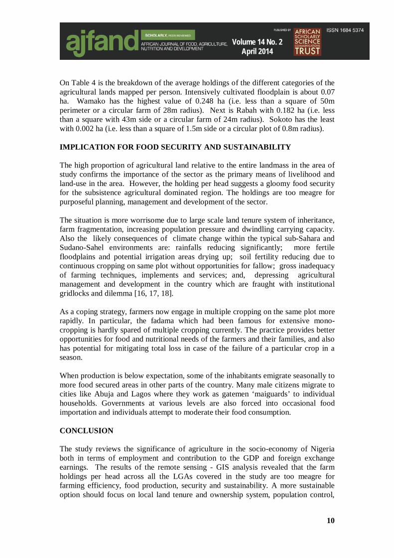
On Table 4 is the breakdown of the average holdings of the different categories of the agricultural lands mapped per person. Intensively cultivated floodplain is about 0.07 ha. Wamako has the highest value of 0.248 ha (i.e. less than a square of 50m perimeter or a circular farm of 28m radius). Next is Rabah with 0.182 ha (i.e. less than a square with 43m side or a circular farm of 24m radius). Sokoto has the least with 0.002 ha (i.e. less than a square of 1.5m side or a circular plot of 0.8m radius). IMPLICATION FOR FOOD SECURITY AND SUSTAINABILITY The high proportion of agricultural land relative to the entire landmass in the area of study confirms the importance of the sector as the primary means of livelihood and land-use in the area. However, the holding per head suggests a gloomy food security for the subsistence agricultural dominated region. The holdings are too meagre for purposeful planning, management and development of the sector. The situation is more worrisome due to large scale land tenure system of inheritance, farm fragmentation, increasing population pressure and dwindling carrying capacity. Also the likely consequences of climate change within the typical sub-Sahara and Sudano-Sahel environments are: rainfalls reducing significantly; more fertile floodplains and potential irrigation areas drying up; soil fertility reducing due to continuous cropping on same plot without opportunities for fallow; gross inadequacy of farming techniques, implements and services; and, depressing agricultural management and development in the country which are fraught with institutional gridlocks and dilemma [16, 17, 18]. As a coping strategy, farmers now engage in multiple cropping on the same plot more rapidly. In particular, the fadama which had been famous for extensive mono-cropping is hardly spared of multiple cropping currently. The practice provides better opportunities for food and nutritional needs of the farmers and their families, and also has potential for mitigating total loss in case of the failure of a particular crop in a season. When production is below expectation, some of the inhabitants emigrate seasonally to more food secured areas in other parts of the country. Many male citizens migrate to cities like Abuja and Lagos where they work as gatemen ‘maiguards’ to individual households. Governments at various levels are also forced into occasional food importation and individuals attempt to moderate their food consumption. CONCLUSION The study reviews the significance of agriculture in the socio-economy of Nigeria both in terms of employment and contribution to the GDP and foreign exchange earnings. The results of the remote sensing - GIS analysis revealed that the farm holdings per head across all the LGAs covered in the study are too meagre for farming efficiency, food production, security and sustainability. A more sustainable option should focus on local land tenure and ownership system, population control,
10

Volume 14 No. 2 April 2014
methods of farming and agricultural infrastructure. The fieldwork on the study showed that often, a typical farmer would have many of his small holdings scattered in different locations. Since it is practically difficult to increase the physical extent of the landmasses in the LGAs, the option of communal ownership of plots adjacent to each other is viable. This would need very good conflict resolution mechanisms nonetheless. Managerially, investment of the revenue and other resources accruing from the oil and gas sector presently should be more vigorous on agricultural development such as provision of inputs and rural development for socio-cultural and economic transformation for agro-based industries and support sectors such as transportation, commerce and recreation.
11

Volume 14 No. 2 April 2014
Table 1: The Local Government Areas studied
S/N Local Government Area
Head-quarters
Population* Area (in km2) Population
Female Male Total (A)
Total Extent (B)**
Coverage by this Study
(C)***
Density (D = A/B)
Estimated for this Study (E = CXD)
1 Dange Shuni Dange 99,888 94,658 194,546 1,210 16.22 77 1,249 2 Kware Kware 62,579 71,320 133,899 554 387.66 165 63,964 3 Rabah Rabah 75,681 73,484 149,165 2,433 89.4 65 5,811 4 Sokoto (N & S) Sokoto 199,887 227,873 427,760 92 28.71 5,154 147,971 5 Wamako Wamako 92,155 87,464 179,619 697 5.06 265 1,341 6 Wurno Wurno 83,343 78,964 162,307 234 222.18 217 48,213
Total 613,533 633,763 613,533 7,154 749.23 174 130,366 Sources:* = National Population Census (NPC, 2006); ** = Bureau of Statistics (2009), *** = GIS Analysis for
the Study
Table 2: The Maps and Images Adopted
Data Type Date of Production Scale Identification and Sources Purpose and Methods
Topographical Map 1965 1:50,000 Sokoto Sheet 10 NE; from
Federal Surveys Dept, Lagos Base Map. Cartographically enlarged to 1:25,000 for image interpretation
Other Maps 2005
1980 -1983
1:5000 -1:15,000
1:100,000 -1:250,000
EA/SA Sketches; from NPC Sokoto
Administrative Maps; from
Sokoto State Secretariat
Updating settlements distribution and augmenting the information on the base (topographical) map. Geo-rectified using appropriate instruments and procedures.
SPOT P, XS and P/XS Nigeriasat Image
1995 & 2007
1:100,000 &
1:200,000
IDRC/Univ. of Waterloo & Lagos;
National Centre for Remote
Sensing Nigeria
Generating the Landuse – Landcover resources for the Study
Field Works and GPS 2008 - - Geo-rectification and Mapping
12

Volume 14 No. 2 April 2014
Table 3: Areal Extent of the Farmlands within each of LGAs Evaluated
LGA Name Total Area
Dange Shuni Kware Rabah Sokoto Wamako Wurno
Cultivated Uplands 35,201.9 1,102.6 16,878.4 2941.3 1,750.7 0.1 12,528.8 Intensively Cultivated Fadama 6,742.9 7.3 5,021.7 619.9 209.0 236.7 648.3 Partly Cultivated Floodplain 11,290.9 0.0 5,533.9 3486.1 0.0 161.3 2,109.6 Plantation/Orchards 192.7 0.0 131.2 8.6 28.8 24.1 0.0 Total Area Cultivated (A) 53,428.4 1,109.9 27,565.2 7055.9 1,988.5 422.2 15,286.7 Population of Study Area (B) 180,376 1,249 63,964 5,811 147,971 1,341 48,213 Per Capita Farmland Holding (C = A/B) 0.30 0.89 0.43 1.21 0.01 0.31 0.32
Source: Summary of the Statistics derived from the GIS analysis Table 4: The per Capita Farm Holdings of the Various Farm Types in the LGAs (ha)
LGA Name Total Farmland
Dange Shuni Kware Rabah Sokoto Wamako Wurno
Cultivated Uplands 0.195 1.152 0.316 0.886 0.019 0.0 0.441 Intensively Cultivated Fadamas 0.037 0.008 0.094 0.182 0.002 0.248 0.023 Partly Cultivated Fadamas 0.063 0.0 0.103 1.026 0.0 0.169 0.074 Plantation/Orchards 0.001 0.0 0.002 0.003 0.0 0.025 0.0
Source: Summary of the Statistics derived from the GIS analysis
13

Volume 14 No. 2 April 2014
REFERENCES
1 Greenland DJ (). Soil Science and Sustainable land management. In: Syers J.K and Rimmer D.L. (Eds). Soil Science and Sustainable Land Management in the Tropics. CAB International, Oxon UK. 1994: 1 – 15.
2 Omara-Ojungu PH Agricultural land management in developing countries. In: Omara-Ojungu P. H (Ed) Resource management in Developing Countries: Themes and Issues in Resource Management. Longman, New York. 1992: 66-85.
3 Obayelu AE Global Food Price Increases and Nutritional Status of Nigerians: The Determinants, Coping Strategies, Policy Responses and Implications. ARPN Journal of Agricultural and Biological Science. 2010; 5(2): 67–80.
4. Akinbode A Population Explosion in Africa and its Implications for Economic Development. Journal of Geography, 1978; 1: 28-36.
5. Adedokun L The Demographic base for Rural Development. In: Adejuyigbe O. and Helleiner F.M (Eds). Environmental and Spatial Factors in Rural Development: Proceedings of the 20th Annual General Conference of the Nigerian Geographical Association. 1977: 15-34.
6. Vaaland T I, Soneye ASO and RA Owusu Local content and struggling suppliers: A network analysis of Nigerian oil and gas industry. African Journal of Business Management (AJBM); 2012; 6(15): 5399-5413.
7. NNPC (Nigerian National Petroleum Corporation) Nigerian National Petroleum Corporation: Yesterday, Today and Tomorrow. Symac Press, Onitsha. 1992.
8. DPR (Department of Petroleum Resources) Oil Concession Map of Nigeria, Scale 1:500,000. Federal Government of Nigeria, Abuja. 1992.
9. FOS (Federal Office of Statistics) Annual Abstract of Statistics. Federal Government of Nigeria Abuja, 1999.
10. Oyeleye DA The diffusion of agricultural Co-operatives in Nigeria. Singapore Journal of Tropical Geography. 1982; 3: 69-85.
11. Soneye ASO Fadama Resources Management in Nigeria: Implications for Sustainable Agricultural Development in the Sokoto-Rima Basin. In: Badejo O and Omitogun A (Eds.). Strategies and Tactics for Sustainable Agriculture in the Tropics. College Press. Ibadan. 2004; 2(1): 209 – 226.
14

Volume 14 No. 2 April 2014
12. Adeniyi PO Agricultural Land Use Inventory and mapping in Nigeria: The Application of Remote Sensing. In: Eden MJ & Parry JT (Eds) Tropical Land Management. JohnWilley & Sons, 1986. Chapter 9; 175-187.
13. Omojola A and ASO Soneye Application of Remote Sensing and GIS techniques for Landuse Landcover Mapping in Middle-Sokoto River, North Western Nigeria. Nigerian Journal of Remote Sensing, 1993; 1(1): 8-11.
14. Ajayi IR, Afolabi MO, Ogunbodede EF and AG Sunday Modeling rainfall as a constraining factor for Cocoa yield in Ondo State. Am. J. Sci. Ind. Res. 2010; 1(2): 127-134.
15. Soneye ASO The Application of Satellite Remote Sensing & GIS in the Evaluation and Revision of Nigerian Topographical Maps. Ph.D. Thesis. University of Lagos: 2000: 284 Pages.
16. Ewuim SC, Nzegwu VN and HU Anaso Agroforestry for sustaining agricultural production in sub-humid tropical environment. In: Badejo M.A and Togun A.O (Eds). Strategies and Tactics of Sustainable Agriculture in the Tropics. College Press, Ibadan. 1998; 1: 32-44.
17. Babatunde RO, Omotesho OA and OS Sholatan Factors influencing food security status of rural farmers in North Central Nigeria. Agricultural Journal. 2010; 2(3): 351-357.
18. Obioha EE Climate Variability, Environment Change and Food Security Nexus in Nigeria. J. Hum. Ecol. 2009; 26(2): 107-121.
15